Mallard Pass Solar Farm - Mallard Pass Solar Farm
←
→
Page content transcription
If your browser does not render page correctly, please read the page content below
Mallard
Pass
Solar Farm

Mallard Pass Solar Farm

Preliminary Environmental Information Report
Volume 3: Appendices
Appendix 7.1: Ecological Baseline Report
May 2022
Mallard’s Pass Solar Farm
Ecological Baseline Report
BLANK PAGE
Issuing office
Worton Park | Worton | Oxfordshire | OX29 4SX
T: 01865 883833 | W: www.bsg-ecology.com | E: info@bsg-ecology.com

   Client                 LDA Design

   Project                Mallard’s Pass Solar Farm

   Version                FINAL

   Project number         P21-135 Ecology baseline report

                           Name                                  Position                          Date

   Originated              Philip Chapman                        Ecologist                         04 November 2021

   Reviewed                John Baker                            Principal Ecologist               17 January 2022

   Reviewed                Peter Shepherd                        Director                          17 January 2022

   Revised                 John Baker                            Principal Ecologist               31 March 2022

   Revised                 John Baker                            Principal Ecologist               10 May 2022

   Approved for
                           Peter Shepherd                        Director                          11 May 2022
   issue to client

   Issued to client        John Baker                            Principal Ecologist               11 May 2022

Disclaimer

This report is issued to the client for their sole use and for the intended purpose as stated in the agreement between the
client and BSG Ecology under which this work was completed, or else as set out within this report. This report may not be
relied upon by any other party without the express written agreement of BSG Ecology. The use of this report by
unauthorised third parties is at their own risk and BSG Ecology accepts no duty of care to any such third party.

BSG Ecology has exercised due care in preparing this report. It has not, unless specifically stated, independently verified
information provided by others. No other warranty, express or implied, is made in relation to the content of this report and
BSG Ecology assumes no liability for any loss resulting from errors, omissions or misrepresentation made by others.

Any recommendation, opinion or finding stated in this report is based on circumstances and facts as they existed at the
time that BSG Ecology performed the work. The content of this report has been provided in accordance with the provisions
of the CIEEM Code of Professional Conduct. BSG Ecology works where appropriate to the scope of our brief, to the
principles and requirements of British Standard BS42020.

Nothing in this report constitutes legal opinion. If legal opinion is required the advice of a qualified legal professional should
be secured. Observations relating to the state of built structures or trees have been made from an ecological point of view
and, unless stated otherwise, do not constitute structural or arboricultural advice.

Derbyshire Oxford Newcastle Newport Swansea Cambridge | BSG Ecology is a trading name of BSG Ecology Ltd
Registered in: England and Wales | No. 12142513 | Registered address: Merlin House No1 Langstone Business Park Newport, NP18 2HJ
Mallard’s Pass Solar Farm

Contents
1     Introduction .................................................................................................................................................. 2
2     Methods ....................................................................................................................................................... 3
3     Results and Evaluation ................................................................................................................................ 8
4     References ................................................................................................................................................22
5     Figures .......................................................................................................................................................23
6     Photographs ..............................................................................................................................................24
Annex 1. Local Wildlife Sites within 2 km of the Site boundary ........................................................................27
Annex 2: Summaries of Relevant Policy, Legislation and Other Instruments ..................................................33
Annex 3. GCN eDNA results ............................................................................................................................41
Confidential Annex 4. Badger survey results ...................................................................................................42

                                                                                       1                                                                11/05/2022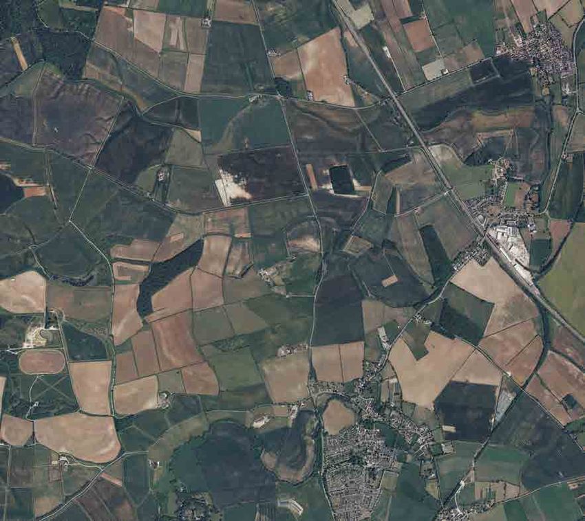
Mallard’s Pass Solar Farm
1 Introduction
Background to commission
1.1 BSG Ecology was commissioned by LDA design in March 2021 to conduct ecological surveys at an
area of land surrounding Essendine on the Lincolnshire-Rutland border, to inform a preliminary
environmental information report required for a future application for development consent for a solar
farm.
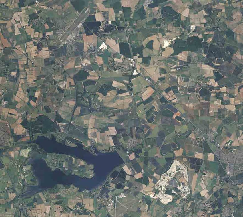
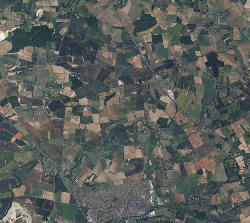
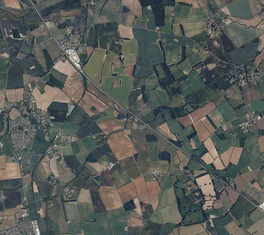
Site description
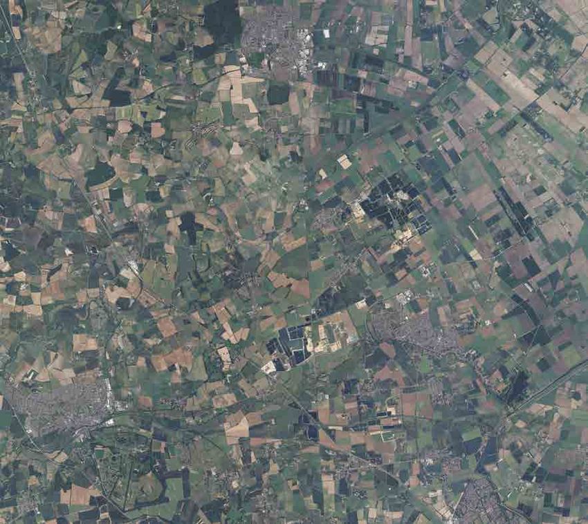
1.2 The “Site” comprises approximately 880 ha of predominantly arable agricultural land north of
Stamford, Rutland (see Figure 1 for the Site boundary). The Site is adjacent to the village of
Essendine and straddles the boundary between Rutland and Lincolnshire. Also included within the
Site are a range of small areas of woodland, hedgerows, field margins and other patches of
grassland, farm buildings, ditches, ponds and a section of the West Glen River.
1.3 The Site is surrounded by predominantly flat or gently undulating agricultural land of similar character.
The town of Stamford is approximately 1.1 km to the south west, and two relatively large areas of
woodland, Newell Wood and Braceborough Wood are directly adjacent to the north-west and north,
respectively. The East Coast main railway line bisects the Site in a north-west to south-east direction.
Description of project
1.4 The Site is being brought forward for a Nationally Significant Infrastructure Project (NSIP) for the
installation of solar photovoltaic (PV) generating Modules and associated infrastructure which would
allow for the generation and export of electricity at land at Mallard Pass, Essendine.
Scope of Study
1.5 This Ecological Baseline Report presents the methods and results of a desk study, extended Phase
1 habitat survey, badger survey, breeding bird survey and great crested newt survey conducted in
2021 by BSG Ecology. Winter bird surveys are also ongoing at the Site. This report presents the
baseline ecological condition of the Site and is intended to inform subsequent assessment of
ecological impacts of the Proposed Development in the Ecological Statement of an Environmental
Impact Assessment.
2 11/05/2022
Mallard’s Pass Solar Farm

2           Methods
            Desk study

2.1         A desk study was carried out to gather existing records and information on designated sites and
            protected or otherwise notable1 species within the local area.

2.2         Information on non-statutory designated sites, protected, notable and invasive species within a 2 km
            radius of the Site boundary was obtained from the Lincolnshire Environmental Records Centre (LRC)
            and from the Leicestershire and Rutland Environmental Records Centre (LRERC). Data were
            received on 04 May 2021. Due to a change in the Site boundary, additional data on Local Wildlife
            Sites within 2km of the additional area (Ryhall Road) were requested from LRERC on 7 January
            2022.

2.3         The Multi-Agency Geographic Information for the Countryside (MAGIC) database (Defra, 2021;
            accessed most recently 17 November 2021) and Natural England’s designated site information
            (Natural England, 2021) were also consulted to establish the ecological context of the Site and to
            search for information on internationally important designated sites up to 10 km from the Site and
            other statutory designated sites within 2 km. This was also searched for internationally important
            statutory sites designated for bats.

2.4         Mapping available on MAGIC was also used to identify ponds within 500 m of the main part of the
            Site and for locations of ancient woodland.

2.5         Additional information pertaining to species recorded along the Drift, an openly accessible lane
            adjacent to the western Site boundary, was supplied by Tom Tew of NatureSpace Partnership in an
            email dated 2 January 2022. This information has been considered where relevant below.

2.6         Detail of the legal and policy protection afforded to relevant protected and notable species and
            designated sites is provided in Annex 2.

            Field survey

            Extended Phase 1 habitat survey

2.7         The majority of the Phase 1 habitat survey was undertaken by Jamie Peacock BSc GradCIEEM,
            Ecologist at BSG Ecology, and Peter Newbold BSc MEnvSci MCIEEM CEcol, Principal Ecologist at
            BSG Ecology and Dr Philip Chapman Ecologist at BSG Ecology. All three are capable and
            experienced habitat surveyors and field botanists.

2.8         Due to the size of the Site it was surveyed in sections over three dates: 30 March, 31 March and 29
            April 2021. This survey involved a walkover with reference to the industry standard guidance (JNCC,
            2010), during which the habitats present were recorded and mapped, with notes made on the species
            present and any features of ecological interest. Photographs were taken to provide supporting
            evidence (see Section 7). Two fields in the north-western part of the Site were covered on a visit in
            December 2021 as these were subsequently added to the Site.

2.9         The Phase 1 habitat survey was “extended” to include an assessment of the potential of the survey
            area to support protected and other species of conservation importance. This included an
            assessment of habitat suitability for bats, hazel dormouse, reptiles and amphibians.

2.10        A preliminary ground-level roost assessment of the trees and buildings within the Site was carried
            out with reference to industry standard guidance (Collins, 2016). The surveyors searched for
            Potential Roost such as slipped roof tiles, woodwork rot holes and wall cavities (buildings) or knot
            holes, lightning scars and lifted bark (trees) which could provide roosting space for bats.

1 Notable species here include those of national or local conservation interest. Species of national conservation interest are Species of
Principal Importance (Section 41 of the NERC Act), those listed in Red Data Lists for England or the UK, red-listed species in Birds of
Conservation Concern list (Eaton et al., 2015), and species designated Nationally Scarce or Nationally Notable. Species of local
conservation interest are those for which Leicestershire and Rutland or Lincolnshire have Biodiversity Action Plans.

                                                                        3                                                   11/05/2022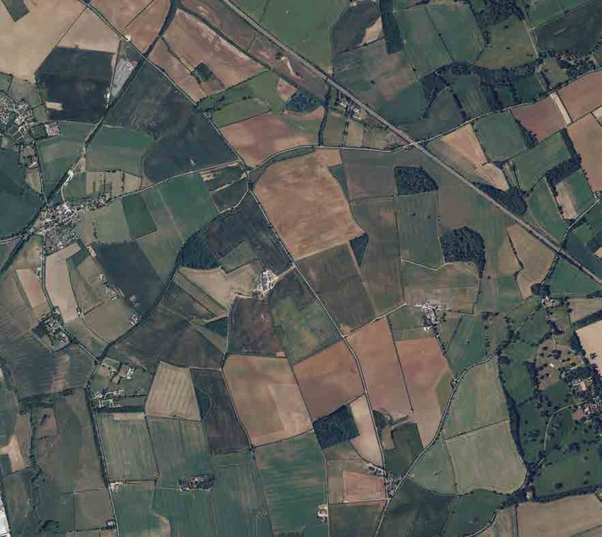
Mallard’s Pass Solar Farm

       Water vole and otter

2.11   To determine whether water vole Arvicola amphibius is present along the Wests Glen River along
       the northern boundary of the Site and in wet ditches onsite, a water vole survey was undertaken on
       09 July 2021 by Peter Newbold, with reference to industry standard guidance (Strachan et al. 2011).
       Peter is an experienced mammal surveyor and is capable of identifying all field signs of water vole
       confidently.

2.12   This guidance recommends two survey visits during the best period for determining presence, with
       one survey in spring-early summer and a second visit (if required, e.g. if presence is not confirmed
       during the first visit) between late summer and mid-autumn. Due to the confirmation of presence of
       water vole on the West Glen River during the early summer visit and the classification of the onsite
       ditches as unsuitable (see ‘Results’ section below), the second visit was not considered to be
       required.

2.13   During the survey visit, the surveyor slowly walked along the banks (both sides) and waded within
       the channel (where accessible and safe to do so). The surveys covered the 1.48 km course of the
       West Glen River where it crosses the Site south of the East Coast Mainline Railway line. The survey
       also covered all ditches on Site which held water at the time of survey. Evidence and potential
       evidence of water vole was noted, and the locations of field signs were marked on an annotated map.

2.14   Evidence of water vole can include droppings, latrines (used to mark territory boundaries or close to
       burrows), feeding signs (neat piles of vegetation close to the water’s edge with a 45o cut at the end),
       footprints and burrows (typically a series of holes along the water’s hedge, but occasionally up to 3
       m up the bankside).

2.15   Due to the suitability of the West Glen River, for otter Lutra lutra, this watercourse was also
       concurrently searched for evidence of this species during the water vole surveys. Evidence of otter
       can include droppings, footprints, holts, feeding remains (chewed fish debris), and characteristic
       muddy slides used to access the water.

       Badger

2.16   A survey for badger Meles meles was undertaken by Peter Newbold and Jamie Peacock in 2021
       during the extended Phase 1 habitat survey. Both surveyors have extensive experience of surveying
       for badger. This survey included searching suitable habitats within the Site for evidence of badgers
       (setts, paths, latrines, foraging holes). The survey covered all linear features and open areas. The
       inner parts of larger woodland parcels were not surveyed as these are all to be retained and no setts
       directly impacted on.

2.17   Any setts located were recorded with information on number of entrances, extent of apparent activity
       in the vicinity and the presence of paths or latrines noted. This information was then used to
       determine the likely nature of the setts and whether they are in current use.

2.18   The setts have been classified based on the following adapted definitions from Neal and Cheeseman
       (1996) and Harris et al. (1994):
       •   Main sett - Normally where cubs are raised and in continuous and regular use throughout the
           year. Typified by large spoil heaps/mounds and well-trodden paths. There can be many
           entrances to the sett (often with some of these disused), although a main sett can sometimes
           only have a single entrance. There may be a scratching tree or playing area near the sett and
           usually a sizable latrine nearby.
       •   Annexe sett - Intermediate-sized and may be used by breeding badgers. Normally close (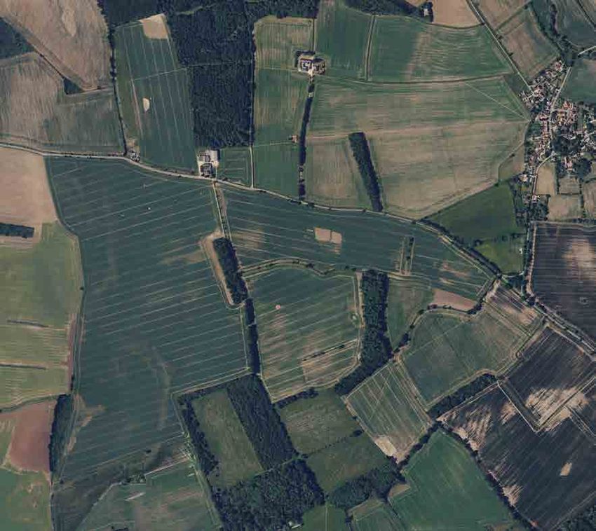
Mallard’s Pass Solar Farm

       •       Outlier sett - Small setts with one or two entrance holes which are used sporadically by badgers
               as a temporary refuge (Neal & Cheeseman, 1996). Spoil heaps are likely to be small and there
               may not be obvious paths connecting to other setts.

       Breeding bird surveys

2.19   To determine the value of the Site for breeding birds, four breeding bird surveys were undertaken in
       April, June and July 2021. Surveys were undertaken by Peter Newbold, assisted by Joe Bishop BSc
       qualCIEEM, Dr. Philip Chapman BA MSc PhD qualCIEEM (both Ecologists at BSG Ecology) and
       Stuart Elsom, an independent ornithological surveyor. All personnel are experienced ornithological
       surveyors and can identify all UK species likely to be encountered by sight and sound.

2.20   Due to the size of the Site and the need to focus survey effort on the morning peak activity period of
       most bird species, the Site was covered simultaneously by a pair of surveyors. Survey dates and
       weather conditions recorded during the surveys are summarised in Table 1. The weather conditions
       during all survey visits were suitable (i.e. no rain or strong winds and good visibility).

       Table 1: Dates, personnel and conditions of breeding bird survey visits

           Date                    Personnel                                    Conditions

           29/04/2021              Peter Newbold and Philip Chapman             7°C, light wind, partial cloud, dry

           11/06/2021              Peter Newbold and Stuart Eslom               16 °C, light wind, partial cloud, dry

           09/07/2021              Peter Newbold and Joe Bishop                 14 °C, light wind, cloudy, dry

           23/07/2021              Peter Newbold and Joe Bishop                 15 °C, light wind, overcast, dry

2.21   During each visit the Site was walked at a slow pace to enable all birds detected to be identified and
       located. Frequent stops were made to scan suitable habitats and to listen for singing and calling
       birds. All areas of suitable breeding habitat within the Site boundary and immediately adjacent areas
       were approached to within 50 m.

2.22   During the survey the location and activity of each bird detected (including those seen or heard) was
       recorded and mapped using standard two-letter British Trust for Ornithology (BTO) species codes
       combined with activity symbols.

2.23   Birds exhibiting breeding behaviour were assigned to one of two categories as part of the
       interpretation carried out after the surveys: likely breeding or confirmed breeding:
           •    Likely breeding: birds heard singing or alarm calling or simply present in suitable breeding
                habitat on one of the survey visits; a pair of birds present in suitable breeding habitat; a repeat
                observation of territorial behaviour (song or alarm calling) on two or more different visits in the
                same location; courtship behaviour or display in suitable breeding habitat; birds apparently
                visiting a nest site; or evidence of nest building (including excavation of a hole).
           •    Confirmed breeding: one or more adults undertaking a distraction display; the presence of a
                used nest or eggshells; the presence of recently fledged or downy young (that are clearly of
                local origin); apparently incubating adults or adults commuting to and from a nest hole; adult
                birds carrying faecal sacs or food for young; or a nest with eggs or young present.

       Wintering Birds

2.24   The Site has also been subject to wintering birds surveys to identify the levels of use of the Site by
       notable species of wintering birds, such as high numbers of farmland passerines, waders or wildfowl.
       Two visits per month were carried out between November 2021 to March 2022 and on each visit, an
       experienced ornithologist surveyed all onsite fields and adjoining fields, where possible, and
       recorded the presence of any waders, any wildfowl, and notable passerines if present in significant
       numbers (e.g. over 30 individuals of a SPI). Each visit was either split over two days or two surveyors

                                                            5                                              11/05/2022
Mallard’s Pass Solar Farm

       covering approximately half of the survey area each (as on 14 December 2021). All survey visits
       were carried out in suitable weather conditions (i.e. avoiding high winds, rain or mist which would
       limit visibility). The Survey Area included the entire Site and adjacent fields, which were viewed from
       within the Site or Public Rights of Way.

2.25   The surveys have been undertaken on the following dates:
        •   24 and 25 November 2021.
        •   29 and 30 November 2021
        •   6 and 7 December 2021.
        •   14 December 2021.
        •   10 and 11 January 2022.
        •   8 and 9 February 2022.
        •   22 and 23 February 2022.
        •   3 and 4 March 2022.
        •   21 and 22 March 2022

       Great crested newt

       HSI assessment

2.26   To determine the suitability of onsite and offsite ponds for great crested newt Triturus cristatus (GCN;
       see “Amphibians” under Results below) they were subject to a Habitat Suitability Index (HSI)
       assessment, with reference to industry standard guidance (Oldham, 2000; ARG UK, 2010). The HSI
       assessment was carried out by Peter Newbold and Jamie Peacock on 21 May 2021 during the Phase
       1 habitat survey visit. Both surveyors are experienced at carrying out HSI assessments.

2.27   The HSI assessment method involves allocating scores to features associated with a pond such as
       size, quality of surrounding habitat and presence of fish. These scores are then combined to calculate
       the overall HSI score for each pond as a number between 0 and 1, with 0 being the least suitable
       and 1 being the most suitable. The HSI score allows each pond to be placed in one of five pre-defined
       categories defining its suitability for great crested newt as follows: 0.80: excellent.

       eDNA survey

2.28   Following the HSI assessment and identification of suitable waterbodies on Site for GCN, an
       environmental DNA (eDNA) survey was conducted on 29 April 2021 by Peter Newbold (Natural
       England Licence 2015-18530-CLS-CLS) and Jamie Peacock (Natural England Licence 2016-20471-
       CLS-CLS) with reference to industry standard guidance (Biggs et al., 2014).

2.29   This survey involved collection of water samples from each suitable waterbody and subsequent
       analysis by an approved laboratory (Surescreen Scientifics Ltd). Online weather forecasts were
       monitored during the fortnight preceding the eDNA sample collection, which confirmed that the
       weather had been suitable for great crested newt survey throughout this period (i.e. overnight
       temperatures generally above 5°C). Following collection of the eDNA samples they were returned to
       the laboratory. The analysis was undertaken by Surescreen and the results returned on 06 May
       2021.

       Other protected species surveys

2.30   Surveys for foraging and commuting bats, roosting bats, hazel dormouse, reptiles, invertebrates and
       plants (detailed botanical survey) were not undertaken, despite some habitats on Site being suitable
       for these species (see “Results” below). The Proposed Development will retain all woody habitats
       (including scattered trees and hedgerows) with a buffer to include existing field margins, as well as

                                                         6                                           11/05/2022
Mallard’s Pass Solar Farm
trees, ponds, and ditches. Since the remaining habitats on Site (arable farmland) are of negligible
value to these species, further protected species surveys were not considered proportionate.
Limitations to methods of field surveys
2.31 A total of 24 ponds were identified within the Site or within 500 m of the Site. Of the offsite ponds 13
(see Figure 2) were not accessed for eDNA survey. Two of these ponds (Ponds 12 and 24) are
located over 250 m from the Site boundary, and if great crested newt is present and breeding in
these ponds, terrestrial newts are considered unlikely to be using the Site. The remaining 11 ponds
range from 50 to 240 m from the Site boundary, and if GCN are present and breeding within these
ponds, individual terrestrial-phase newts may be found within grassland (including field margins) and
hedgerows in the nearby areas of the Site. Additional surveys of these ponds (eDNA) will be carried
out in 2022 with additional surveys (population estimates) to be carried out if needed.
2.32 As part of the badger surveys, the inner parts of larger woodland parcels were not surveyed. This is
not likely to be a significant limitation as the woodlands are all to be retained and no setts were
present on the edges of the woodland, therefore no setts directly impacted on. Even if setts are
present within these woodlands, fragmentation will be avoided with measures intended to keep the
Proposed Development permeable by creating gaps accessible by badgers in security fencing.
2.33 No other limitations were identified for the field surveys.
7 11/05/2022Mallard’s Pass Solar Farm
3 Results and Evaluation
Designated sites
3.1 No internationally important designated sites for bats are present within 30 km of the Site. The
closest is Eversden and Wimpole Woods Special Areas of Conservation (SAC), located over 60 km
to the south. This is designated for its population of barbastelle bat Barbastella barbastellus.
3.2 Four international designated sites are present within 10km of the Site, the Rutland Water Special
Protection Area (SPA) and Ramsar Site, which are located approximately 4.8km to the south-west
of the Site, Baston Fen SAC is located 4.46 km north-east of the Site boundary, Grimethorpe SAC
is located 4.67 km north of the Site boundary and Barnack Hills and Holes SAC is located 6.8 km
south of the Site boundary.
3.3 The Rutland Water SPA is designated primarily for its wintering population of shoveler Anas clypeata,
teal Anas crecca, wigeon Anas penelope, gadwall Anas strepera, tufted duck Aythya fuligula,
goldeneye Bucephala clangula, mute swan Cygnus olor, coot Fulica atra, merganser Mergus
merganser and great crested grebe Podiceps cristatus. This site is also designated as an SPA for its
assemblage of water fowl including the species above.
3.4 It is also designated as a Ramsar site for its wintering population of gadwall and shoveler and the
overall assemblage of waterfowl.
3.5 Grimethorpe SAC and Barnack Hills and Holes SAC are designated for their calcareous grassland
communities and are also orchid rich priority sites. Grimethorpe is also designated for the presence
of early gentian.
3.6 Baston Fen SAC is designated for its population of spined loach fish. It is located on the Glen River,
a tributary of which is the West Glen River.
3.7 A total of eight national statutory designated sites are present within 2 km of the Site. All these are
Sites of Special Scientific Interest (SSSIs) (see Figure 1).
3.8 Ryhall Pasture and Little Warren Verges SSSI is directly adjacent to three parcels of land in the
north-west of the Site. This SSSI includes an area of one of the semi-natural unimproved limestone
grassland and features a characteristic calcareous plant community. This site also includes with
adjacent species-rich roadside verges which fall within Lincolnshire.
3.9 Newell Wood SSSI is 340 m north-west of the Site. This SSSI comprises an area of semi-natural
woodland on the site of former clay pits. The woodland is dominated by pedunculate oak Quercus
robur and silver birch Betula pendula with a predominantly acidic ground flora, although some open
areas with distinctly calcareous plant species are also present.
3.10 Great Casterton Road Banks SSSI is located 915m from the Site. This comprises a small area of
calcareous grassland with a mosaic of open grassland and scrub.
3.11 Tolethorpe Road Verges SSSI comprises the verges on both sides of Ryhall Road along the site
boundary north-east of Great Casterton. These verges support species-rich calcareous grassland.
3.12 Tickencote Marsh SSSI is located approximately 1 km west of the site boundary and Great Casterton.
This supports species rich grazing marsh.
3.13 Bloody Oaks Quarry SSSI is located approximately 430 m west of the site at the junction included in
the site boundary on the A1. This supports species-rich calcareous grassland.
3.14 East Wood, Great Casterton SSSI is located approximately 1.3 km north west of the site boundary.
It supports ash-oak-wych elm woodland with a rich flora typical of ancient woodland.
8 11/05/2022Mallard’s Pass Solar Farm
3.15 A total of 98 non-statutory sites designated as Local Wildlife Sites (LWS) are present within 2 km of
the Site. The majority of these are designated for habitats (predominantly hedgerows, grassland and
woodland) with many also featuring locally or nationally scarce species. These LWS are listed in
Table A in Annex 1 and shown in Figure 1.
3.16 Nine of these LWSs are located wholly or in part within the Site boundary. These are:
• Carlby/Essendine Verge LWS.
• Essendine Dismantled Railway Embankment LWS.
• Essendine, Hedgerow south side MacMillan Way LWS
• Ryhall/Essendine south-east of the Freewards (south side) LWS.
• Ryhall/Essendine Hedge south-east of the Freewards (south side) LWS.
• Essendine Verge south-east of The Freewards (north side) LWS.
• Ryhall RVNR: Crossroads to the Drift junction (west side) LWS.
• Ryhall Verge (B1176): from crossroads to Ryhall Farm Cott track (east side) LWS.
• Essendine, Hedgerow north side MacMillan Way LWS.
3.17 An additional 26 LWS are directly adjacent to the Site boundary or within 10 m (generally separated
by a minor road). Most of these sites are protected hedgerows of lengths of road verge.
3.18 The remaining sites are between 15 m and 2 km from the Site boundary.
Habitats
3.19 The habitats present within the Solar PV Site and the Mitigation and Enhancement Areas are shown
in Figure 3 and described in Table 2 below.
3.20 Some areas of woodland on Site, together with all the boundary and internal hedgerows, qualify as
Habitats of Principal Importance (HPI) 2. Depending on hydrological characteristics and aquatic
species present, the West Glen River and the onsite ponds have the potential to be HPI.
3.21 Table 2. Habitats present at the Site.
Habitat Description/notes
There are multiple parcels of woodland distributed across the Site, some of
which are semi-natural broadleaved woodland (see Photographs 1-2). These
woodlands are dominated by pedunculate oak Quercus robur and ash
Fraxinus excelsior, but silver birch Betula pendula, willow Salix sp., hybrid
black poplar Populus x euramericana and alder Alnus glutinosa are present.
Most woodland parcels feature a relatively dense understorey, consisting
predominantly of hazel Corylus avellana, holly Ilex aquifolium, elder
Sambucus nigra and hawthorn Crataegus monogyna.
Broadleaved
semi-natural Ground flora is relatively diverse, with species including bluebell
woodland Hyacinthoides non-scripta, ground ivy Glechoma hederacea, dog’s mercury
Mercurialis perennis, lords and ladies Arum maculatum, wood sorrel Oxalis
acetosella, ragged robin Silene flos-cuculi, spurge laurel Daphne laureola,
wood anemone Anemone nemorosa and foxglove Digitalis purpurea.
Some of these species are ancient woodland indicator species, however
MAGIC does not identify any of the woodlands as ancient semi-natural
woodland. This woodland meets the definition of the Lowland mixed
deciduous woodland HPI (Maddock, 2011).
2 As defined under Section 41 of the Natural Environment and Rural Communities Act 2006. See Annex 2
9 11/05/2022Mallard’s Pass Solar Farm
Most external boundaries and some internal boundaries of the Site feature
native hedgerows (Photographs 3-4).
Some species-rich sections (as shown in Figure 3) are present with over five
woody species per 30 m section. These include hawthorn, blackthorn Prunus
spinosa, field maple Acer campestre, holly, elder, hazel, cherry Prunus sp.,
bramble Rubus fruticosus, wych elm Ulmus glabra, field elm Ulmus minor
with occasional dog rose Rosa canina. The majority of hedgerows on Site are
species-poor, and formed by one to three woody species, usually blackthorn
and/or hawthorn.
Many hedgerows across the Site feature one or several standard trees,
including mature pedunculate oak Quercus robur, beech Fagus sylvatica,
ash, hybrid black poplar, and various willow species Salix spp. (Photograph
Hedgerows 4).
The hedgerow bases largely support common species such as lords and
ladies, dog’s mercury, common nettle Urtica dioica, cleavers Galium aparine,
ground-ivy and common hogweed Heracleum sphondylium, however the first
two species are indicative of older hedgerows and predominantly only present
in the species rich hedgerows.
Most hedgerows, particularly in the east of the Site, are intensively managed
by cutting and show structural indicators of poor condition (abundant
horizontal and vertical gaps), with some hedgerows defunct and/or left to grow
out into scrubby treelines.
All the hedgerows on Site are considered to meet the description of the
Hedgerows HPI (Maddock, 2011).
An analysis of aerial imagery and mapping revealed the presence of 24 ponds
on Site or within 500 m of it. There are nine ponds on the Site or on its
boundary, with an additional 13 ponds within 500 m of the Site boundary (see
Figure 2).
Of the nine ponds present within the Site or on its boundary, six held water
(including Pond 3 in Photograph 5 – see Figure 2). The majority of these
Ponds ponds are situated at the edge of pockets of woodland and are heavily
shaded, although most ponds had aquatic and marginal vegetation present.
These ponds are described in detail under “Amphibians” below. All the ponds
on Site holding water have potential to meet the description of the Ponds HPI
(Maddock, 2011) based on the presence of aquatic species and water quality
parameters. With the exception of the eDNA survey (see below) these was
not assessed in detail.
The West Glen River flows through the west of the Site (Photographs 6-7).
This watercourse features a natural river channel dominated by marginal
vegetation, predominantly common reed Phragmites australis and bulrush
Typha latifolia. Emergent/submerged plants were also present in patches, but
a detailed survey was not undertaken to identify these down to species level.
Flowing water The banks of the river comprise of a mosaic of species poor semi-improved
grassland, semi-improved neutral grassland (see below), scattered scrub and
tall ruderal.
The river has the potential to meet the description of the Rivers HPI (Maddock,
2011) based on the presence of aquatic species and water quality and
hydrological parameters. As a precaution this is considered to be an HPI,
The majority of the Site consists of arable farmland (Photographs 8-9). This
is largely in intensive agricultural management, with the majority of field
Arable farmland margins measuring less than 1 m in width, particularly in the west and east of
the Site. Many fields are very large (the largest being over 58 ha),. The fields
supported a very low diversity of arable weed species.
10 11/05/2022Mallard’s Pass Solar Farm
During the surveys, the fields were either bare having recently been ploughed,
supported cereal stubble or young crops.
The arable fields are of low intrinsic ecological value and are not HPIs. The
intense nature of the agricultural practice and very limited margins mean they
are not considered to be ecologically valuable.
Areas of improved grassland are present across the Site, predominantly
forming margins to arable fields. (All arable field margins are this habitat type
or poor semi-improved grassland as described below; only margins over 1 m
in width are mapped as grassland on Figure 1).
Improved Improved grassland areas are dominated by perennial rye grass Lolium
grassland perenne with very few herbs present (predominantly white clover Trifolium
repens and creeping buttercup Ranunculus repens). At the time of the survey,
these areas were unmanaged and had relatively long sward (averaging
approximately 25 cm).
This grassland does not meet the description of any HPIs.
Areas of species-poor semi-improved grassland are present across the Site
(Photograph 10), predominantly forming margins to arable fields (see above).
These support a slightly higher plant species diversity, and in addition to the
species described above, contain grasses such as cock’s-foot Dactylis
Poor semi- glomerata, false oat grass Arrhenatherum elatius and red fescue Festuca
improved rubra. Herbaceous species include greater plantain Plantago major,
grassland broadleaved dock Rumex obtusifolium, chickweed Stellaria media, dandelion
Taraxacum agg., groundsel Senecio vulgaris, spear thistle Cirsium vulgare,
yarrow Achillea millefolium, ragwort Jacobaea vulgaris, and common mouse-
ear Cerastium fontanum and creeping thistle Cirsium arvense.
This grassland does not meet the description of any HPIs.
Slightly more diverse grassland is present in the west of the Site, adjacent to
the river and in two small fields either side of the Essendine Dismantled
Railway Embankment LWS (Photograph 11). This is considered to be semi-
improved neutral grassland. In addition to the grassland species listed above,
additional grass species such as common bent Agrostis capillaris, crested
Semi-improved dog’s-tail Cynosurus cristatus and rough meadow grass Poa trivialis are also
neutral grassland present. Additional herbaceous species include ribwort plantain Plantago
lanceolata, meadow buttercup Ranunculus acris and red clover Trifolium
pratense.
Due to the relatively low species richness and absence of indicator species
for lowland meadows, this grassland does not meet the description of the
Lowland Meadows HPI (Maddock, 2011).
Many of the broadleaved woodland parcels on Site show clear evidence of
recent planting (tree guards, regular lines of young or semi-mature trees) or
Broadleaved have been visibly recently planted on historic aerial imagery (Photograph 12).
plantation The majority of plantation woodland is broadleaved, with a mixture of similar
woodland native species to the semi-natural woodland. Due to the recent age of the
plantations, the understorey layer is poorly developed or absent, and the
ground layer is species-poor. This woodland does not qualify as an HPI.
Coniferous Approximately 0.2 ha of woodland towards the east of the Site is dominated
plantation by planted non-native coniferous trees including spruce Picea sp. and fir
woodland Abies sp. This woodland does not qualify as an HPI.
A former railway embankment in the west of the Site (designated as the
Essendine Dismantled Railway Embankment LWS) features dense mixed
Dense scrub scrub of comparative high species richness (Photograph 13). Woody species
include hawthorn, blackthorn, field maple, holly, elder, hazel, cherry Prunus
sp., bramble, wych elm Ulmus glabra, and occasional dog rose Rosa canina
11 11/05/2022Mallard’s Pass Solar Farm
all present. The ground flora was diverse with bluebell, dog’s mercury, lords
and ladies, wood sorrel, and foxglove all present.
Other patches of dense scrub were also present across the western half of
the site, these were all species-poor and often dominated by a single species,
generally either bramble, hawthorn or blackthorn. The ground flora within
these patches was either non-existent or very sparse and lacking in diversity.
Small pockets of tall ruderal vegetation are present, particularly in the western
half of the Site. These are too small to map (and are not shown on Figure 3)
Tall ruderal
and often form transitional areas between other habitat types. Species noted
vegetation
included common nettle, broad-leaved dock and common hogweed. This
habitat does not meet the description of any HPIs.
A mixture of dry and wet field ditches are present across the Site (Photograph
14). These generally did not feature aquatic vegetation, with any vegetation
Ditches present reflecting the surrounding habitat (generally species-poor grassland
field margins as described above). This habitat does not meet the description
of any HPIs.
A variety of scattered mature trees are located across the Site. These are
dominated by pedunculate oak and ash, and often indicate the lines of former
Scattered trees hedgerows. In one location in the east of the Site two lines of planted oaks
form an avenue each side of a farm track (Photograph 18). Many of these
trees have suitability for roosting bats as discussed below.
Some access tracks and an area around farm buildings in the east of the Site
Bare ground are compacted gravel with little or no vegetation and are classified as bare
ground. This habitat does not meet the description of any HPIs.
Nine farm buildings are present in the Site. These are discussed in detail
Buildings
under “Bats” below”. This habitat does not meet the description of any HPIs.
Parts of the area around the buildings in the east of the Site and short sections
Hardstanding of metalled road within the Site boundary are classed as hardstanding. This
habitat does not meet the description of any HPIs.
3.22 The Site does not support any ancient woodland, however there are parcels of this outside the Site
on the north-eastern site boundary (replanted ancient woodland at Braceborough Little Wood) and
north-western site boundary (ancient woodland and replanted ancient woodland at Newell Wood).
Protected species
3.23 The relevant legislation and policy on protected and notable species is set out in Annex 2.
Bats
3.24 All bats and their roosts are a European Protected Species (see Annex 2). Seven species area also
SPIs and local BAPs exist for these species in Lincolnshire, Leicestershire and Rutland.
3.25 Combined, the records centres returned 205 records of at least eight bat species from within 2 km of
the Site. Of these, 96 were identified to species level. These comprised brown long-eared bat
Plecotus auritus (28 records), common pipistrelle Pipistrellus pipistrellus (19), soprano pipistrelle
Pipistrellus pygmaeus (17), Daubenton’s bat Myotis daubentonii (ten), noctule Nyctalus noctula
(nine), Natterer’s bat Myotis nattereri (five), Leisler’s bat Nyctalus leisleri (four), barbastelle (three)
and whiskered bat Myotis mystaciunus (one).
3.26 The remaining records comprised unknown bat species (79 records), unidentified Pipistrellus species
(18) and unidentified Myotis species (11).
3.27 The closest record of a bat to the Site was a roost of an unknown bat species recorded from
droppings 120 m west of Site boundary near Essendine Church in 2005. All bats are European
12 11/05/2022Mallard’s Pass Solar Farm
protected species (see Annex2) while soprano pipistrelle, Barbastelle and brown long-eared bat are
additionally Species of Principal Importance (SPI)3.
Roosting
3.28 The southern group of three buildings in the east of the Site are agricultural barns built around a steel
frame with corrugated asbestos cement and/or corrugated steel cladding. These barns were not
accessed internally during the Phase 1 habitat survey; however, no PRFs were visible externally and
given the structure of the buildings they are considered unlikely to present any roosting opportunities
internally. These buildings have Negligible suitability for roosting bats.
3.29 A total of 163 field and hedgerow trees across the Site were assessed as having at least Low
suitability for roosting bats, although due to the scale of the Site and the fact that all mature trees are
proposed for retention in the development, detailed identification of potential roost features and
grading of suitability was not carried out. Trees with bat suitability are shown in Figure 4. Additionally,
mature patches of woodland on Site are likely to contain further trees with roosting opportunities for
bats.
Foraging and commuting
3.30 The intensively-managed arable fields which make up the great majority of the Site are likely to be
of very low value for foraging bats.
3.31 The parcels of woodland (particularly areas of mature woodland with large trees) have suitability for
foraging, as do hedgerows, scrub and lines of trees, especially where mature trees and other features
such as ponds are present and the boundary features are reasonably continuous. Small pockets of
semi-improved neutral grassland also have moderate suitability for foraging, especially where these
are associated with hedgerows or other woody features.
3.32 Hedgerows and lines of trees (as well as linear scrub features such as the Essendine Dismantled
Railway Embankment LWS) may also provide important commuting routes for bats, especially where
they form continuous corridors across the site or between woodland patches, and/or have wide
grassland margins. The West Glen River represents a High Suitability feature for both foraging and
commuting bats.
3.33 Due to the likely retention in the proposed development of all buildings, mature trees, woodland,
scrub and hedgerows and the likely enhancements associated with conversion of intensively-
managed arable land to grazed grassland around the solar panels plus additional landscaping and
planting, further survey for bats was not considered proportionate.
Badger
3.34 Badger is protected under the Protection of Badgers Act 1992 (see Annex 2).
3.35 Combined, the records centres returned 98 records of badger Meles meles from within 2 km of the
Site. Seven records originated from the Site, five of which relate to sets within the Essendine
Dismantled Railway Embankment LWS in the centre of the Site.
3.36 The intensively-managed arable fields which make up the great majority of the Site are of low value
for foraging badgers. However, the woodland, hedgerows, scrub and other woody features have
suitability for foraging and sett-building this species, and patches of non-woody, semi-natural habitats
such as grassland field margins and tall ruderal vegetation provide additional suitable habitat.
3.37 A total of 18 badger setts were located across the Site (see Confidential Figure 7). The details are
given in Confidential Annex 4.
3 As defined under Section 41 of the Natural Environment and Rural Communities Act 2006. See Annex 2.
13 11/05/2022Mallard’s Pass Solar Farm
Hazel Dormouse
3.38 Hazel dormouse is a European Protected Species (see Annex 2) as well as an SPI and local BAP
species in Leicestershire and Rutland.
3.39 The records centres returned no records of hazel dormouse Muscardinus avellanus from within 2 km
of the Site. This species is rare but present in Rutland and Lincolnshire. The hedgerows and
woodland patches provide suitable habitat for this species, although the relatively poor connectivity
of hedgerows (particularly in the eastern part of the Site where hedgerows have frequent gaps) limit
the suitability of the Site at a landscape level. It is therefore possible that this species is present on
Site.
Water vole
3.40 Water voles and their burrows are fully protected under the Wildlife and Countryside Act 1981 (as
amended - see Annex 2) and are an SPI and a local BAP species in Lincolnshire and Leicestershire
and Rutland.
3.41 The records centres returned 12 records of water vole Arvicola amphibius from within 2 km of the
Site. The closest record of this species to the Site was approximately 40 m west of the Site boundary
in the West Glen River near Essendine and dates from 1996.
3.42 During the water vole survey visit, the field ditches on site were found to be unsuitable for water vole.
Most of those which held water during the extended Phase 1 habitat survey were dry at the time of
the water vole survey visit and all ditches are intensively managed, with only narrow margins of short
semi-improved grassland and an absence of suitable dense aquatic or marginal vegetation (such as
rushes, sedges or reeds) that could provide cover either for feeding water voles, or for water vole
burrows. The arable farmland and woodland that comprises the majority of the Site is not suitable for
water vole.
3.43 The West Glen River does feature extensive cover of aquatic and marginal plants and is suitable
habitat for water vole. During the survey visit, evidence of the presence of water voles was found
along a stretch of the West Glen River measuring approximately 180 m where it crosses the Site.
This comprised six burrows, five latrines and four feeding stations (see Figure 5).
Otters
3.44 Otter is a European Protected Species (see Annex 2) and a local BAP species in Lincolnshire and
Leicestershire and Rutland.
3.45 The records centres returned 20 records of otter. The closest record of an otter to the Site was an
observation approximately 15 m north of the Site boundary on the West Glen River west of Carlby in
2009.
3.46 The West Glen River has suitability for this species, with areas of dense cover for holt-building. No
evidence of otter was returned from the West Glen River during the otter and water vole survey visits;
however, this species may be present along this watercourse.
Other mammals
3.47 Combined, the records centres returned 82 records of three other protected and notable mammal
species from within 2 km of the Site. These comprise brown hare Lepus europaeus (41 records),
hedgehog Erinaceus europaeus (38), and harvest mouse Micromys minutus (three).
3.48 One record of brown hare from 1977 was returned within the Site, although this record was only
returned to 2 km precision and may or may not correspond to this species on Site. The next closest
record of a brown hare to the Site was 250 m south-west of the Site in 1977. The arable land
comprising the majority of the Site, as well as smaller parcels of grassland, are suitable habitat for
14 11/05/2022Mallard’s Pass Solar Farm
this species and it was recorded during all breeding bird survey visits with a peak count of 17
individuals on 09 July. Brown hare is an SPI and a local BAP species in Lincolnshire.
3.49 The closest record of a hedgehog to the Site was 30 m north, to the east of Braceborough Grange,
in 2015. The Site has some suitable habitat for hedgehog in the hedgerows, woodland, and grassland
therefore this species may be present on Site. Hedgehog is an SPI.
3.50 The closest record of a harvest mouse originates from 1.0 km west of the Site in 1977, and all three
records are over 40 years old. The intensive arable farmland which dominates the Site represents
sub-optimal habitat for this species, with the poor semi-improved grassland patches and field margins
providing habitat of a higher suitability. No evidence of harvest mouse was detected during the
extended Phase 1 habitat survey, although this species is hard to detect and may be present on Site.
Harvest mouse is an SPI.
3.51 No records of polecat Mustela putorius were returned by the LRC or LRERC but this species is
reportedly present on the western edge of the Site along the Drift (information supplied by Tom Tew).
This is an SPI.
Birds - breeding
3.52 All wild birds, their nests, eggs and young are protected under the Wildlife and Countryside Act 1981
(as amended; see Annex 2).
3.53 Combined, the records centres returned 1,775 records of birds from within 2 km of the Site,
comprising 80 species.
3.54 Of these, the Site has suitability for breeding for three species specially protected under schedule 1
of the Act: red kite Milvus milvus (116 records), kingfisher Alcedo atthis (66) and barn owl Tyto alba
(30).
3.55 The woodland, farm buildings and mature trees are suitable for barn owl; the closest records of this
species were onsite south-west and north-west of Essendine in 2001 and 2010 respectively. The
woodland and mature trees are suitable for red kite, although this species is gradually expanding its
range and is still scarce as a breeding species in Northamptonshire. The closest record of this
species was onsite south-west of Essendine in 2019. The West Glen River corridor is suitable for
kingfisher; the closest record of this species was 50 m east of the Site near Banthorpe Lodge in
2017.
3.56 In addition, the Site has suitability for 15 species listed as SPI: starling Sturnus vulgaris (189), lapwing
Vanellus vanellus (93), skylark Alauda arvensis (73), house sparrow Passer domesticus (68), linnet
Linaria cannabina (35), yellowhammer Emberiza citrinella (32), song thrush Turdus philomenos (27),
yellow wagtail Motacilla flava (21), reed bunting Emberiza schoeniclus (19), turtle dove Streptopelia
turtur (14), tree sparrow Passer montanus (12), bullfinch Pyrrhula pyrrhula (10), cuckoo Cuculus
canorus (10), corn bunting Emberiza calandra (nine) and grey partridge Perdix perdix (seven).
3.57 The arable farmland on Site is suitable for breeding by skylark, lapwing, yellow wagtail and grey
partridge, which are ground nesting species. Suitable habitat for the remaining SPI species listed
above is confined to the woodland, hedgerows and scrub.
3.58 Records of bullfinch, corn bunting, lapwing, linnet, skylark, turtle dove, yellow wagtail and
yellowhammer were returned from onsite, although the majority of returned records were to 1km of
2km precision so these may or may not correspond to actual observation from within the Site
boundary.
Breeding bird survey
3.59 A total of 48 bird species were recorded during the bird survey as either confirmed or likely breeding
on Site. These are listed in Table 9. The indicative central point of each territory or location of
individual bird records is shown in Figure 6.
15 11/05/2022Mallard’s Pass Solar Farm
Table 9: Summary results of breeding bird survey
Breeding Status
Common name Scientific name Total pairs
Confirmed Likely
Blackbird Turdus merula ✓ 32
Blackcap Sylvia atricapilla ✓ 21
Blue tit Cyanistes caeruleus ✓ ✓ 63
Carrion crow Corvus corone ✓ ✓ 11
Chaffinch Fringilla coelebs ✓ 28
Chiffchaff Phylloscopus collybita ✓ ✓ 42
Coal tit Periparus ater ✓ 11
Collared Dove Streptopelia decaocto ✓ 3
Dunnock Prunella modularis ✓ 20
Garden warbler Sylvia borin ✓ 1
Goldcrest Regulus regulus ✓ 4
Goldfinch Carduelis carduelis ✓ 15
Great spotted
woodpecker Dendrocopos major ✓ 1
Great tit Parus major ✓ 24
Greenfinch Chloris chloris ✓ 3
Green woodpecker Picus viridis ✓ 3
Heron Ardea cinerea ✓ 1
House sparrow Passer domesticus ✓ 4
Jackdaw Coloeus monedula ✓ ✓ 6
Jay Garrulus glandarius ✓ 1
Kestrel Falco tinnunculus ✓ ✓ 4
Lapwing Vanellus vanellus ✓ 1
Lesser whitethroat Curruca curruca ✓ 1
✓
Linnet Linaria cannabina 12
✓
Little Egret Egretta garzetta 1
✓
Long-tailed tit Aegithalos caudatus ✓ 2
✓
Magpie Pica pica ✓ 8
✓
Mistle thrush Turdus viscivorus 4
✓
Nuthatch Sitta europaea 3
✓
Pheasant Phasianus colchicus 10
✓
Pied wagtail Motacilla alba 1
✓
Raven Corvus corax 1
✓
Red kite Milvus milvus ✓ 3
✓
Red-legged partridge Alectoris rufa 2
✓
Reed bunting Emberiza schoeniclus 6
✓
Robin Erithacus rubecula 37
✓
Rook Corvus frugilegus 1
✓
Skylark Alauda arvensis ✓ 58
✓
Song thrush Turdus philomelos 11
✓
Starling Sturnus vulgaris 7
16 11/05/2022Mallard’s Pass Solar Farm
✓
Stock dove Columba oenas 3
✓
Treecreeper Certhia familiaris 1
✓
Whitethroat Curruca communis ✓ 36
✓
Willow warbler Phylloscopus trochilus 1
✓
Woodpigeon Columba palumbus ✓ 31
✓
Wren Troglodytes troglodytes 58
✓
Yellow wagtail Motacilla flava 2
✓
Yellowhammer Emberiza citrinella 35
3.60 In addition to the above, a further 12 bird species were recorded during the survey visits for which
no evidence of breeding was noted. This included individuals flying over the Site or species which
may breed locally but for which suitable nesting habitat either does not occur on Site, or where no
behaviour suggesting breeding was recorded. These species are summarised in Table 10 below
together with notes on use of the Site.
Table 10: Non-breeding bird species recorded during surveys.
Common name Species name Notes
Pellets in a barn immediately adjacent to the
Site boundary east of Ryhall, however this
Barn owl Tyto alba
appears to be a roost with no indication of
breeding.
Occasional flyovers. No suitable breeding
Black-headed gull Chroicocephalus ridibundus
habitat.
Occasional hunting or roosting birds in eastern
parts of the Site. Suitable breeding habitat
Buzzard Buteo buteo
(mature trees) but no breeding behaviour
noted.
Two flushed from the eastern part of the Site
close to the railway on the April visit. Suitable
Grey partridge Perdix perdix
habitat present and may breed but no breeding
behaviour noted.
Observed foraging close to the Site boundary
south of Essendine village on the early July
House martin Delichon urbicum
visit. Some suitable habitat present (old farm
buildings) but no breeding behaviour noted.
Three flushed from pond in east of Site on April
visit. Suitable breeding habitat present (river
Mallard Anas platyrhynchos
edges, ponds) and may breed but no breeding
behaviour observed.
One individual calling from West Glen River on
early July visit. Suitable breeding habitat
Moorhen Gallinula chloropus
present (river edges, ponds) and may breed
but no breeding behaviour observed.
One flyover during April visit. Small pockets of
Siskin Spinus spinus suitable habitat present (coniferous/mixed
woodland) but no breeding behaviour noted.
Observed in vicinity of farm buildings in east of
Spotted flycatcher Muscicapa striata Site on both July visit. Possibly breeds but no
breeding behaviour observed.
Many foraging flyovers during later visits. Some
Swallow Hirundo rustica suitable habitat present (old farm buildings) but
no breeding behaviour noted.
One flyover during second July visit. Some
Swift Apus apus suitable habitat present (old farm buildings) but
no breeding behaviour noted.
17 11/05/2022Mallard’s Pass Solar Farm
Male observed on April visit in east of Site. No
Wheatear Oenanthe oenanthe
suitable habitat and probably a migrant.
3.61 Of the 48 species of bird recorded as breeding within or adjacent to the Site, 15 appear on one or
more schedules or lists of species of conservation importance (see Table 11).
3.62 Table 11: Birds of conservation importance breeding on Site.
Species WCA Schedule 1 SPI Red List1 Amber List1
Dunnock
Greenfinch
House sparrow
Kestrel
Lapwing
Linnet
Mistle thrush
Moorhen
Red kite
Reed bunting
Skylark
Song thrush
Starling
Stock dove
Whitethroat
Willow warbler
Woodpigeon
Wren
Yellow wagtail
Yellowhammer
1
Species of high (red list) and medium (amber list) conservation concern included in Birds of Conservation Concern 4 (Eaton
et al., 2015)
3.63 The surveys have recorded several breeding bird species listed as SPIs, and species which are local
BAP species in Lincolnshire and Leicestershire and Rutland.
Birds-wintering
3.64 Of the 1775 birds of 80 species returned by the records centres, the arable farmland on Site has
suitability to support some wintering waterbirds. Due to the relatively dry, undulating topography of
the Site and lack of low-lying areas prone to flooding, suitability is likely to be confined to wader
species preferring open dry ground such as lapwing (93 records) and golden plover (no records).
One record of lapwing from 2019 was on Site south of Essendine. The Site is also suitable for loafing
gulls such as herring gull Larus argentatus, lesser black-backed gull Larus fuscus and black-headed
gull Chroicocephalus ridibundus, although no records were returned of these species.
3.65 The Site is not considered suitable supporting habitat for any of the species listed under the
designation of the Rutland Water SPA and Ramsar site (see ‘Designated Sites’ section above) all of
which require extensive areas of aquatic habitats not present on Site.
3.66 The Site supports a small number of larger fields, but these are largely in intensive arable use.
Therefore, there is potential for wintering species to include species such as lapwing and golden
18 11/05/2022You can also read