Malton Pickering Cycle Route Proposal - March 2017 Prepared for Ryedale District Council in Partnership with North Yorkshire County Council ...
←
→
Page content transcription
If your browser does not render page correctly, please read the page content below
Malton ‐ Pickering Cycle Route Proposal

                                                                                           March 2017

 Prepared for Ryedale District Council in Partnership
        with North Yorkshire County Council

Cover Photo: Malton Market Square © The Fitzwilliam Malton Estate Top of Market Place, Pickering © Sustrans
About Sustrans
Sustrans makes smarter travel choices possible, desirable and inevitable. We’re a leading
UK charity enabling people to travel by foot, bike or public transport for more of the
journeys we make every day. We work with families, communities, policy-makers and
partner organisations so that people are able to choose healthier, cleaner and cheaper
journeys, with better places and spaces to move through and live in.
It’s time we all began making smarter travel choices. Make your move and support Sustrans
today. www.sustrans.org.uk

Head Office
Sustrans
2 Cathedral Square
College Green
Bristol
BS1 5DD

© Sustrans
Registered Charity No. 326550 (England and Wales) SC039263 (Scotland)
VAT Registration No. 416740656

    Report Number                   T116-YH-RE-01
    Revision Number                 -
    Purpose of issue                Final
    Issue date                      08th March 2017
    Date printed
    Author                          Rupert Douglas / Chris Smithard
    Checked by                      Mike Babbitt / Mark Robinson

                                                          2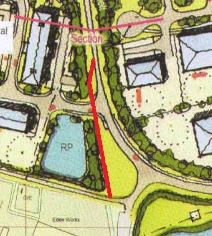
Contents

 1.     Introduction.................................................................................................................................... 4
        Detailed Proposals:......................................................................................................................... 6
            2. Malton to Eden Camp ............................................................................................................ 6
            3. Riggs Road ............................................................................................................................ 10
            4. Riggs Road to Kirby Misperton ............................................................................................. 11
            5. Kirby Misperton to Four Lane Ends...................................................................................... 12
            6. Four Lane Ends to Pickering ................................................................................................ 16
            7. Malton Rail Station and Malton ........................................................................................... 18
 8.     Phasing and Cost Estimates ......................................................................................................... 20
 9.     Signing .......................................................................................................................................... 22
 10. Cycle parking ................................................................................................................................ 24
 11. Funding ......................................................................................................................................... 25
 12. Usage and Benefits ....................................................................................................................... 28
 13. Future Maintenance..................................................................................................................... 30
 14.        Monitoring and Evaluation ...................................................................................................... 30
 15.        Local Consultation .................................................................................................................... 31
 16.        Onward Routes ......................................................................................................................... 33
 Pickering ‐ Dalby Forest ‐ Scarborough ................................................................................................ 33
 Pickering ‐ Kirkbymoorside ‐ Helmsley ................................................................................................. 33
 Malton – Castle Howard / Howardian Hills – Easingwold or York ....................................................... 33
 Kirkham – Stamford Bridge (and York)................................................................................................. 34
 Appendix A: Layout of proposed livestock market and industrial site ................................................ 35
 Appendix B: Showground cycle route to Haygate Lane....................................................................... 36
 Appendix C: Usage and Benefits of the National Cycle Network in 2013 ........................................... 37
 Appendix D: Drawings T116‐YH‐DR‐01 to 06……………………………………………………………………………………38

                                                                           3
1. Introduction
1.1. A safe and attractive cycle route linking Malton and Pickering has long been an aspiration of the
local communities. This obvious missing link was picked up by the Raising Cycling in Ryedale
group (now Ryedale Cycle Forum) with Ryedale District Council commissioning Sustrans, a leading
UK charity enabling people to travel by foot, bike or public transport for more of the journeys we
make, to come up with a proposal for developing a cycle route between the two market towns
that could become part of the National Cycle Network. All documents and consultations were
undertaken in partnership with North Yorkshire County Council.
How the new route extends the current National Cycle Network into Ryedale and North Yorkshire
1.2. Malton lies at the north‐western edge of the Yorkshire Wolds, while across the low‐lying and flat
Vale of Pickering is Pickering itself, a popular gateway to the North York Moors National Park.
There are ideas for onward routes from Pickering into the National Park and onwards towards
Scarborough and Whitby (discussed at the end of this report) that, if developed could make
Malton and Pickering an important hub for cycle access to the Yorkshire Wolds, moors and coast.
1.3. One of the principal reasons for developing the route is to help people make every day journeys
by bike. This may be to work, school, shops, the train station and other local amenities. An
increase in cycling can bring many benefits including health, financial, environmental and easing
congestion. A copy of the ‘Usage and Benefits of the National Cycle Network in 2013’ is included
in the appendix. Below are some of the realistic cycling journeys the proposed route
accommodates for.
South side of Norton to Showfield Lane Industrial Estate, Malton – 2.0 miles
Malton Train Station to Eden Camp ‐ 2.2 miles
Kirby Misperton and Flamingo Land to Pickering – 3.7 miles
4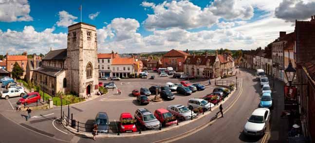
Malton Train Station to Kirby Misperton and Flamingo Land – 7.7 miles
Malton Train Station to Pickering – 11.4 miles
1.4. The route between Malton and Pickering identified in this report follows an alignment that
experienced cyclists could already use. For a few thousand pounds it could be signposted and
publicised as the cycle route between Malton and Pickering. However it would not be seen as an
attractive cycling route, especially for younger families and less confident cyclists due to poor
surfacing, unsuitable roads and hazardous junctions. This report makes recommendations on how
the route could be brought up to a standard suitable for these user groups and a route that could
become part of the National Cycle Network.
1.5. In some instances costs could be lowered by upgrading existing tracks to a lower standard, but
this would add to ongoing maintenance costs and from experience it is often easier to find capital
funding for these projects than it is to find maintenance money. We therefore recommend higher
initial costs so that the route shouldn’t need any major works for at least 20 years.
1.6. In terms of prioritising sections of the route it is worth bearing in mind two aspects. The first is
whether the scheme can be broken down into standalone phases which meet a desire for
journeys so that the cost can be spread throughout different years or funding streams.
Consideration should be given to sections that link residential areas to employment sites, town
centre, shops, schools, visitor attractions and the train station as these are likely to be the most
used sections.
1.7. It is also important that the most challenging aspects of the route are tackled properly and not
left to be upgraded at a later date. This will lead to a larger initial increase in cyclists using the
route and also make it easier to justify completing other phases as high usage warrants it. There
are numerous historic examples of the easier sections being delivered first leaving a dangerous
section on the ‘to do’ list and the result is a route that is underutilised and unable to justify
maintaining the capital expenditure already invested. In our opinion the most challenging aspects
on this project are Kirby Misperton Road and the level crossing between Malton and Norton
which have to be tackled to provide a safe, convenient and comfortable route for cyclists.
1.8. This route will help to bring benefits both to local people and tourists in Ryedale. It will provide an
enhanced opportunity for people to make every day journeys to work, school, shops, the train
station and other amenities as well as leisure trips.
5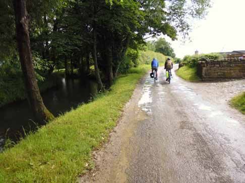
2. Detailed Proposals – Malton to Eden Camp
  2.1   Though there is obvious sense in starting a route at Malton Rail Station and connecting in
        to National Cycle Network 166, but there are numerous difficulties in reaching the centre
        of Malton from the south. The easiest possible (as described in section 7) option still
        includes difficult sections that would be challenging for novice cyclists and may attract
        criticism if signed. As such, options have been looked at that would create a route start or
        ‘trail head’ as close as possible to the centre of Malton, with easy cycle access to the quiet
        roads and bridleways to the north.
  2.2   An obvious location for a start point would be the Wentworth Street long stay car park
        with adjacent public toilets. Secure cycle parking and way‐finding information could be
        sited here, and it is only a short walk into the centre of Malton.
  2.3   The layout of car parking spaces would need to be examined to see if it they could be
        relined in such a way as to give a segregated cycle route from the toilet block through the
        car park and along Smithson Court up to Pasture Lane. From here the two routes
        described below can be easily reached.
  2.4   Via Rainbow Lane to Freehold Lane. This route is approximately 60% on existing roads.
        The route that has been looked at that could provide direct access from Malton’s Market
        Place (as well as the trailhead) to the north is using Spital Street and Princess Road with a
        straight‐over crossing of Newbiggin. A raised table at the crossing point and associated
        traffic calming is desirable to help keep traffic speeds low. This route would provide
        access from Malton centre to the housing and industry in the north‐east of the town but
        would be more marketable as a route starting within the Wentworth Street car park.
  2.5   The route out of Malton would then use Princess Road and Peasey Hills Road. Although
        the roads are 30mph it is likely, due to the environment and layout, that speeds are lower.
        Our main concern here is the hill; as you move away from the town centre and uphill
        cycling speeds are reduced therefore increasing the differential in speeds between motor
        vehicles and cycles. The junction between Princess Road, East Mount and Peasey Hills
        Road could be modified by simplifying the junction so there is only one intersection rather
        than the current three, with the main benefit being to reduce traffic speeds as vehicles
        negotiate the junction, especially for traffic coming away from the town centre and
        turning into Peasey Hills Road. This change would help to improve visibility for those
        approaching the junction from East Mount and preparing to turn right into Peasey Hill
        Road, and would also help to relieve the pinch point on Peasey Hills Road just after the
        junction.

                                                6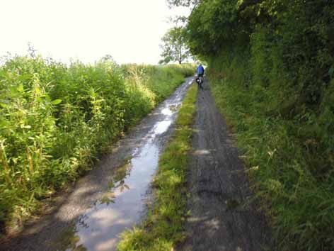
2.6   The junction between Peasey Hills Road, Pasture Lane and Rainbow Lane could be
      modified to make it easier for cyclists to use. The junction mouths are wide and it would
      be beneficial to both cyclists and pedestrians to have these tightened up to reduce traffic
      speeds into the two minor roads if this on‐road alternative route is adopted.

                 Junction between Peasey Hills Lane, Pasture Lane and Rainbow Lane.

2.7   Narrow Rainbow Lane already has a sealed surface to the other side of the A64 bridge.
      There are several speed bumps which should have bypasses round / sections cut out to
      allow cycles to pass without discomfort. Any development taking place that potentially
      increases access and motor vehicle traffic on Rainbow Lane should include measures that
      retain its safety and convenience for cyclists and other non‐motorised users.
2.8   Borough Mere Lane after the A64 bridge is currently a rough track and needs an all‐
      weather surface to make this an attractive and comfortable route for most types of
      cyclists. This would need to be built to take heavy farm vehicles and further discussions
      would be needed with the land owner and North Yorkshire County Council’s Public Rights
      Of Way Team to agree suitable measures to deter unauthorised vehicles from using this
      as a cut through (there is an existing barrier between Freehold Lane and Great Sike Road).

                                                 7
2.9 The North York Moors Joint Local Access Forum should also be involved in agreeing the
nature and extent of surface and other changes to this and other bridleway sections of the
proposed route, particularly with regard to its use by horses.
Looking north along Borough Mere Lane from the bridge over the A64
2.10 Via Outgang Lane. The route via Pasture Lane would provide a good connection through
the north east of Malton which passes areas of housing and employment. The route
alignment may not be entirely attractive to recreational cyclists however, in particular to
families or novices. Another route from the proposed start point in the Wentworth Street
car park would be available via Outgang Road if a crossing point over Pasture Lane and a
short shared‐use link was created on its north side. This would require some widening into
a private field and minor ramp works to enable a cycle link up the steep verge on Pasture
Lane near the Smithson Court junction. Minor carriageway narrowing may also be
required for a very short section of narrow footway opposite the junction with Wentworth
Street. This route would, however require a much longer section of bridleway to be
upgraded (Outgang Road and either Lowfield Road or Ryton Style Road).
2.11 In conjunction with the Broughton Road housing development, there are plans for a new
roundabout near to this location in the near future, which will remove the traffic lights.
Proposals will need to be reviewed once with these works are complete.
2.12 Upgrade the surface on Outgang and Ryton Style Road (1.8km) to a sealed surface.
Outgang Road leads out from Malton past the allotments and over the bypass.
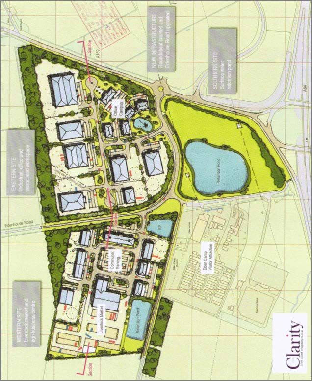
2.13 Both options would then use Freehold Lane allowing the route to run directly past Eden
Camp visitor attraction and through the planned relocated Livestock Market and industrial
estate. This new development could cause a problem depending on the levels and types
8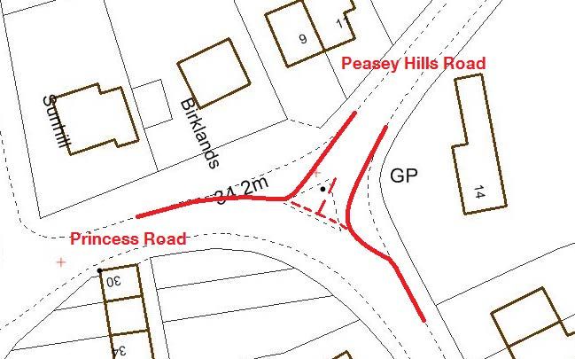
of traffic, although a short section of off road cycle route could be built to prevent cyclists
       and market traffic from needing to share the same road space (shown in the diagram
       below).

                The track past Eden Camp is typical of the potholed bridleways north of Malton

A feasible alignment of an off road route shown in red with a safe crossing over the new Livestock Market traffic.

                                                        9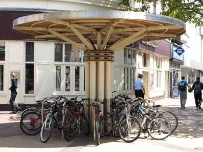
3. Detailed Proposals - Riggs Road

  3.1   To continue north toward Pickering the route proposes to use Borough Mere Lane and
        Great Sike Road (see photo below) although the latter is already maintained to a
        reasonable standard with tarmac strips and a grass centre.

                                        Great Sike Road

  3.2   Riggs Road is a quiet country roads with low traffic volumes and speeds. There is concern
        however that, with the development of a livestock market and industrial estate in the
        Eden Camp area, traffic volumes will rise.
  3.3   There are also a number of locations where the roads are narrow with poor visibility, for
        example at New York Cottage, where the road kinks sharply twice. Signs warning of the
        likely presence of cyclists and the cutting back of vegetation may help reduce the
        potential conflict between fast moving vehicles and cyclists which may be in the middle of
        the road. Other than addressing these issues, additional direction signing only would be
        needed to provide a cycle route here.

                                              10
4. Detailed Proposals – Riggs Road to Kirby
Misperton
4.1 Dicky Grounds Lane and Blansby Lane are both similar in character to Riggs Lane. It is
suitable for use by the majority of cyclists, although a pair or tight corners would benefit
from warning signs and / or “SLOW” markings.
4.2 Habton Road is wider than the other roads between Malton and Misperton, and traffic
seems to travel quickly along it. It is also a signed through route. At present the character
of the road is such that it could be signed as a cycle route, but the development of
fracking operations at the nearby KM8 well site would likely lead to an increase in traffic
volumes and HGV use, and use as a signed cycle route would then need to be reviewed.
4.3 An alternative has been identified that would provide a more suitable route for family
cycling and is more direct. This would use farm tracks leading north to Kirby Misperton
passing White Lily, North West Farm and Sandlands Farm. There is currently an access
road of reasonable quality but it is only part designated footpath and part has no Public
Right of Way designation at all. Signage at both entrances to the road also makes it clear
that cyclists are not welcome. Close work with landowners would be needed to make this
alternative a reality.
4.4 This alternative route would also require a section of new track to fill in a missing link
between two lengths of farm access track.
115. Detailed Proposals - Kirby Misperton to Four Lane
Ends
5.1 Habton Road enters the village of Kirby Misperton and joins Kirby Misperton Road at a
roundabout. Kirby Misperton Road is the main route into Flamingo Land Theme Park and,
as such can be very busy at certain times of day. It is also a very straight road and speeds
can be high. It is therefore an inappropriate road on which to sign a cycle route. A
number of alternatives have been examined.
5.2 The roundabout at Kirby Misperton would benefit from some minor improvements to
make this a less intimidating environment for cyclists. Tightening up the geometry of the
roundabout would provide these benefits and this could be done relatively easily by
increasing the deflections on the approaches and providing an overrun strip in the centre.
North Yorkshire Highways will have to be satisfied that the tightened alignment will safely
allow the passage of HGVs and buses.
5.3 Roundabout to Kirby Misperton Bridge Option A ‐ One option is to provide a verge path on
the north side of Kirby Misperton Road. The verge is wide for the most part but there are
sections where the hedgerow, and in one case a house, come very close to the
carriageway. Detailed survey work and discussions with adjacent landowners would be
needed to see if a continuous route could be achieved. This would need to involve some
track creation in the verge, some to the back of hedgerows and would involve some short
pinch points.
5.4 The possibility of taking the path behind the hedge and along the field edge before
emerging back into the highway verge, where it is wider has been discussed with
Flamingoland. They have acknowledged this in principle and left the door open for
further discussion and negotiation if funding materialises. This path would continue to
the bridge over Costa Beck.
The road out of Kirby Misperton is currently not suited to the route’s target cycle users. Preferably the road would be
avoided but if this cannot be achieved then suitable alterations to the carriageway should be made.
5.5 Roundabout to Kirby Misperton Bridge Option B ‐ Another more ambitious alternative is to
have the route turn eastwards opposite the village hall to follow a farm track, then a field
edge path leading to Kirby Misperton Bridge. Again this would involve close work with
and cooperation from local landowners, and of course a funding source for new path
creation.
125.6 Both options would take cyclists as far as Kirby Misperton Bridge, which crosses Costa
Beck. Here potential route turns north towards quiet roads to the south of Pickering. To
reach these however, any route would need to pass Lendales Farm. This can be reached
via a bridleway, however this requires use of more track adjacent to Kirby Misperton
Road. This would be difficult to achieve as a ditch runs adjacent to the road making the
verge narrow and not wide enough to provide a cycle track in. There is also a drop in
height into the adjacent field, making any field‐edge track difficult to access. This would
not be impossible however, although more negotiation would be required with the
landowner.
5.7 The bridleway track surface to Lendales Farm is good put would benefit from a tarmac
surface, although the farmer does maintain this track well.
The bridleway to Lendales Farm from Kirby Misperton Road
5.8 The current bridleway runs through the middle of Lendales Farm. Sustrans and NYCC
recently met with the farmer and discussed issues and options, the main concern being
encouraging more cyclists into a working farm yard. It is proposed that initially clearer
signing be installed requesting that cyclists Slow Down and the situation monitored. A
future option would be to divert the bridleway away from the farm yard should the need
arise. A bridleway gate adjacent to the main gate at the entrance to the farm yard would
improve ease of access and should be discussed further with the farmer.
13The current bridleway passes through the middle of a working farm yard.
5.9 To avoid having to run the route alongside Kirby Misperton Road more than is necessary
and to avoid signing a route through Lendales Farm yard we have devised a route running
alongside Costa Beck. Further discussion would be needed with the landowner but he has
indicated he is open to this option. A new bridge over the Beck (construction of a similar
bridge in Tickton cost approximately £45k in 2014) would be needed as well as a length of
track over the fields.
5.10 The road surface from Barker Stakes to Lendales Farm is in very poor condition and
requires resurfacing throughout. Cheaper patching work could be implemented, but it is
likely to require further work in a relatively short amount of time.
The road north from Lendales Farm is in need to refurbishment.
5.11 From Leas Farm down to Barker Stakes there are drainage issues and some potholes
which should preferably be addressed to reduce the dangers to cyclists. Pickering
Showground has also indicated there is a potential cycle route out onto Haygate Lane and
to join the Malton – Pickering route.
14The road past Leas Farm is an attractive cycling route especially as is passes the river.
5.12 Goslipgate and Leas Lane as far as Leas Farm would be fine in good weather but flooding
is an issue after wet weather.
Looking south from the old railway bridge down Gosipgate
156. Detailed Proposals – Four Lane Ends to Pickering
6.1 The route into Pickering uses quiet residential roads which have traffic calming to reduce
vehicle speeds.
6.2 The main junction in Pickering between Southgate, The Ropery, Hungate and Vivis Lane is
large, busy and not currently suited to the route’s target cyclists. To better accommodate
cyclists, the end of Train Lane should be opened up with a dropped kerb feature for
cyclists to use in the north bound direction from Vivis Lane only. An Advanced Stop Line
(ALS) for cyclists going in this direction would be beneficial.
6.3 For the southbound direction cyclists would need to use The Ropery which is busy and
congested. An ASL would improve the route, but it still could only be considered as
interim NCN at best.
6.4 Numerous alternative routes into the centre of Pickering have been examined. The best
alternative to the Vivis Lane junction would be to use improved paths linking to Willow
Court, across the A170 and through a lane around the side of the Co‐op leading into the
Market Place. This has issues with using an elderly people’s residence and crossing the
A170 however. Further work is needed to fully understand all the possibilities for access
into the centre of Pickering, but also how cyclists could cut through (or possibly bypass)
central Pickering to reach ongoing routes.
6.5 Potter Hill is a quieter road and offers a route into the centre of Pickering.
6.6 There is some cycle parking in Pickering but more parking should be spread throughout
the town.
16Cycle parking at the top of Market Place
Cycle parking at the bottom of Market Place
177. The Link to Malton Rail Station and Malton.
7.1 The sense in connecting Malton to the railway station and Norton is obvious. Ideally the
proposed route should start in Norton (across the River Derwent) where the current
National Cycle Network already passes through as part of the Yorkshire Wolds Cycle
Route. There are, however, a number of issues which are described below which mean
that a meaningful, signed cycle route is likely to be unachievable at this time.
7.2 Looking ahead, we are aware that a scheme to create a shared‐use cycle/footway
alongside the A64 between the Huttons Ambo road end and Musley Bank to the south
west of Malton is progressing through the Highways England (HE) ‘value management
process’. Last reports (March 2016) indicated that subject to funding for design and
construction becoming available, the scheme could go ahead in 2018/19. If developed,
the alignment of National Cycle Network 166 (Yorkshire Wolds Cycle Route) could then
change significantly between Huttons Ambo (utilising the small suspension bridge across
the River Derwent) and the centre of Malton.
7.3 The onward alignment to link back with the Yorkshire Wolds Cycle Route would most
likely still be through Norton to Scagglethorpe, and then Settrington.
7.4 Langton Road is already partly traffic calmed and connects into the current National Cycle
Network 166.
7.5 St Nicholas Street is a quiet residential road, although it does have a public car park half
way down.
7.6 The level crossing and Welham Road / Church Lane junction is one the most hazardous
parts of the route. Options have been examined to provide shared‐use facilities that
would enable easy cycling by novices, however, the complex junction layout means that
useful off‐carriageway facilities are unlikely to be achievable. North Yorkshire County
Council undertook a reprioritisation scheme in 2016, that simplified the junction and
make it easier for cyclists travelling along Welham Road.
7.7 Under the new rail franchises there are now proposals for enhanced rail services on the
Scarborough to York line, which would result in the level crossing being closed more
often. The long term vision for pedestrians and cyclists over the railway should be the
reintroduction of a bridge. There are several locations this could be located although the
ramp on the north side of the railway will probably be the difficult part to accommodate.
However, it could be accommodated by using the Network Rail yard close to the level
crossing.
Looking south across the level crossing
187.8 Secure cycle parking at the station should be on offer. As a first stage this could be 10
cycle lockers with the next step being a swipe card entry cycle storage area.
7.9 Railway Street does not appear too busy and speeds seem to be lower than the 30mph
limit, maybe partially due to the speed cushion already in place. Due to this, the road
seems an ideal candidate for making it officially 20mph.
7.10 We understand that there is discussion about making Railway Street one way and if that
does happen then a contraflow lane for cyclists should be included as part of the redesign.
From a walking and cycling perspective it would be beneficial if vehicles were restricted in
turning into Railway Street from the level crossing as there is conflict between these
vehicles and pedestrians currently trying to cross Railway Street. This is due to relatively
high turning speeds and regular encroachment of vehicles onto the pavement when trying
to make the turn.
7.11 There is then a staggered crossing of Yorkersgate. This right turn will be intimidating for
novice cyclists as they would need to make the manoeuvre across what is a busy road and
may find themselves waiting between two traffic flows. A number of options have been
looked at to improve this situation, including converting footways to shared‐use or
providing right‐turn pockets, but none have proved to be feasible.
7.12 The use of Saville Street is a key part of the route into the town centre. It is one‐way
however, in the northbound direction. Proposals to provide contraflow cycling have been
examined but options are restricted by parking and loading arrangements and the
available road width close to the junction with Yorkersgate. This means southbound
cyclists will need to use Market Place and Market Street to reach Yorkersgate and then
use over 200m of the busy Yorkersgate itself to reach Railway Street.
Looking down Saville Street from Market Place
198. Phasing and Costing
8.1 Depending on the levels of funding that become available, it may be necessary to provide
the route in sensible phases:
Phase 1 ‐ Malton to Eden Camp
Phase 2 ‐ Eden Camp to Kirby Misperton
Phase 3 ‐ Kirby Misperton to Pickering
8.2 Phase 1: Malton to Eden Camp. (Blue on dwg T116‐YH‐DR‐01) This represents an
opportunity to connect into the Eden Camp and possible future employment sites.
8.3 The scale of cost of this phase largely depend on the extent to which the tracks on which
is proposes to run are resurfaced. They can be cycled on in their current state, but this is
likely to lead to complaints from those expecting a higher quality from a new route. If
costs of this work, which is really maintenance, could be met from the North Yorkshire
Highways Maintenance budget, then the works to allow cycle access to it would be
minimal.
8.4 2.8km of track (designated bridleway) would be required to link Malton to Eden Camp and
this forms the bulk of the costs shown below. Not resurfacing or having it done from a
maintenance budget would remove most of the £312,400 estimated plus most of the
Project Management and Contingency costs. The degree of resurfacing could also be
lowered, for example to provide only tarmac strips for use by cyclists or by infilling the
worst of the potholes. This could greatly reduce these costs, but may reduce the
likelihood of some cyclists using the route.
8.5 The use of the alternative route (red on dwg T116‐YH‐DR‐01) would reduce the amount of
bridleway used to around 2km, which would reduce the upgrading costs by £88,000 +
management and contingency on‐costs. This alternative is also likely to greatly reduce the
users on the route however.
208.6 Phase 2: Eden Camp to Kirby Misperton. Again costs will depend on the degree of upgrade
which Borough Mere Lane and Great Sike Road are subject to. Once Riggs Road is joined,
costs reduce to signage only.
8.7 The alternative route suggested between White Lily and Sandlands Farm (red on dwg
T116‐YH‐DR‐03) would add an additional £270,000 of upgrading works (only if taken to
full tarmac construction) plus project management and contingency add‐ons. Fees for
dealing with landownership issues would also be required. These are estimated to be
around £10,000 per deal.
8.8 Phase 3: Kirby Misperton to Pickering. Almost all costs are related to the proposed track
along Kirby Misperton Road and the route through Lendales Farm. A considerable cost
may also need to be added to resolve any land owner negotiations adjacent to Kirby
Misperton Road. This is likely to be around £10,000 per deal.
8.9 The costs of phase 3 would increase significantly if the alternative route (red on dwg
T116‐YH‐DR‐04) was progressed. This would provide a far higher standard of route into
Pickering however.
8.10 Maintenance. The above costs do not include fees for ongoing maintenance. It is assumed
that the bridleways and roads will be continued to be maintained from the Public Right of
Way and Highway’s budgets. Any new sections of track are likely to need commuted
sums. The level of this will need determining when the final route alignment is chosen.
However, past routes developed by Sustrans have included 25 year maintenance
agreements that have commuted sums of around £130,000 per kilometre.
8.11 Monitoring. Figures do not include provision of automatic counters or the undertaking of
manual counts. The quantity of these will need determining as part of the bid
requirements. Automatic counters cost around £2000k each.
219. Signing
9.1 The proposed route needs to be sufficiently well signed so that it is easy to follow in both
directions from / to principal origins and destinations, and to contribute to its safety.
9.2 A balance must be struck between providing clear and reliable information, and avoiding
visual clutter (especially in any conservation areas) and unnecessary maintenance liability
that excessive signing can cause, so care is needed when considering their design and
placement.
9.3 Surface markings may provide a useful alternative to post mounted signs, and the use of
existing features such as lamp columns should be maximised to avoid clutter and minimise
costs.
9.4 Cyclists Dismount or End of Route signs are not appropriate and should not be necessary
on National Cycle Network routes.
9.5 Cycle specific route signing also raises awareness of cyclists amongst other road users and
helps promote the route as well.
© Sustrans
9.6 The National Cycle Network route number 167 is already allocated to the proposed new
route.
Signs for traffic‐free shared use paths:
This sign, with no white lines, tells you that it’s a shared‐use, unsegregated cycle and pedestrian route.
22To give more protection to pedestrians and to indicate that cyclists should give priority to pedestrians,
signs such as this can be used. These signs would not be permitted on a ‘highway’, but are perfectly
suitable on traffic‐free routes such as through parks.
Where use by horse‐riders also occurs (e.g. on bridleways) appropriate amendments are required.
9.7 Signage costs are included as a 3% of Works Cost in the following Cost Estimates.
2310. Cycle parking
10.1 Cycle parking is an essential element of a cycle network. It should cater for all destinations
and be sited close to building entrances where it can be observed by passers‐by and the
building occupier. The preferred type of public cycle parking is the Sheffield stand, in
conjunction with shelters where bikes are left for long periods. Care should be taken when
siting cycle parking to avoid obstructions to pedestrians including those with visual
impairments.
Examples of urban town centre cycle parking. © Sustrans
10.2 Malton and Pickering town centres could be locations where new / additional cycle
parking may be appropriate in relation to the proposed route.
10.3 Cycle parking costs have not been included on the cost estimates. However as an
indication a standard Sheffield Stand costs approximately £250 to source and install.
2411. Funding
Department for Transport
11.1 Currently we are not aware of any DfT funding that might help with the cost of the
proposed Malton ‐ Pickering cycle route.
11.2 Last year, the DfT issued its draft Cycling Delivery Plan and is calling for “expressions of
interest in working with government on partnership projects to increase levels of walking
and cycling”. One of the Plan’s themes is “to improve infrastructure and planning
arrangements for cycling and walking”.
11.3 Admittedly there are no clear offers of new infrastructure funding associated with this but
many local authorities are preparing or in some case have already responded.
11.4 North Yorkshire County Council is the highway authority for the Ryedale area and is
currently considering what form of partnership working it may wish to seek with the DfT.
11.5 Whilst not the highway authority, Harrogate Borough is preparing its own “expression of
interest” to the DfT, as is City of York Council (the highway authority for the York area).
11.6 Looking further ahead, a new Infrastructure Bill has become an Act of Parliament (The
Infrastructure Act) and so for the first time the Secretary of State for Transport will be
required by law to set out a strategy for cycling and walking infrastructure and
importantly the funding provided to meet it.
North Yorkshire County Council
11.7 The County Council will add the proposed Malton – Pickering route to its reserve list of
potential transport schemes once this report has been finalised.
11.8 Apart from some road safety schemes, the County Council doesn’t currently have any
funding for new transport infrastructure (cycling or other modes) and so will not at this
stage be seeking Committee approval for the route or undertaking any further assessment
and development work.
11.9 The County Council may have some Pinch Point funding aimed at removing bottlenecks on
the local highway network which are impeding growth which could be relevant to the
proposed route.
11.10 Should they become aware of any suitable funding opportunities they will refer to the
reserve schemes list.
11.11 If Ryedale District Council were for example to identify some possible funding for all or
part of the proposed then the County Council would look to see how it could help with
delivery.
11.12 The view has been expressed that “the most promising source of potential funding to
deliver the route would be for the District Council to seek S106 contributions from
potential developers”, and so the proposal is understood to be being raised internally so it
can be taken into account in their development control process.
25Ryedale District Council
11.13 The District Council are discussing the above mentioned Pinch Point funding with the
County Council.
11.14 The District Council will also continue to monitor other potential funding opportunities
relating to economic development and regeneration which may be appropriate for this
project, and progress funding applications as appropriate.
Developer contributions
11.15 Developer contributions are often referred to as Section 106 planning obligations. These
planning obligations provide a means of ensuring that developers contribute towards the
infrastructure and services needed to make proposed developments acceptable in land
use planning terms. Contributions may be made as financial payments or as direct works.
11.16 It is understood that the developers building houses on the Broughton Rd. and Pasture
Lane sites have and will be making S106 payments for use on sport and recreation
facilities in Ryedale and specifically the Malton area. These contribution and others that
the Council will be receiving should be considered for helping to fund the delivery of the
proposed route.
Local Enterprise Partnership (LEPs)
11.17 Infrastructure is one the key themes for the York, North Yorkshire & East Riding LEP, and
investment in some major road schemes has been secured. However, on its own the
proposed new route is unlikely to represent a sufficiently beneficial scheme in the current
circumstances, and may need to be packaged with other cycling infrastructure investment
proposals with an emphasis on growing the economy (including the visitor economy), and
good quality local jobs through improved access to be considered.
11.18 The LEP does have a section in its Strategic Economic Plan regarding Growing the Visitor
Economy of North Yorkshire’s Protected Landscapes one of which is the North York Moors
National Park with Pickering as a recognised southern gateway.
11.19 Sustrans is in discussion with the YNYER LEP regarding support it can provide through a
DfT funded scheme aimed at developing a robust economic and business case for future
investment in cycling / walking infrastructure in identified growth towns and along the
East Coast.
European Union
11.20 The new EU financial period has started and the European Cyclists’ Federation (ECF) has
set a goal of €6 billion being spent on cycling between 2014‐20. ECF has reviewed the
relevant funding documents and identified numerous opportunities to fund cycling
related measures in all but one 28 member states if successful projects are put forward.
11.21 ECF will be providing more detailed information about the programming documents
which set out funding priorities during 2015, but it will be worth checking with relevant
ERYC colleagues dealing with EU funding, or directly with the relevant managing authority,
to see if there’s any possible correlation.
11.22 Rural Development Programme for England funding will become available through the
LEADER North York Moors, Coast and Hills Local Action Group from April 2015. It is
thought funding will go to schemes that improve rural life and businesses, promote
26environmentally friendly ways of managing land, and sustain existing and create new
areas of woodlands, and so might offer some potential for contributing to costs.
11.23 EU rural development funding for tourism infrastructure (including cycling infrastructure)
may becoming available for public bodies and charities to bid for through the EAFRD
programme, and which we understand the YNYER LEP will be providing more information
about and some strategic direction. (Subject to changes following the EU Referendum
2016)
Town / Parish Council and local fundraising:
11.24 Small amounts of funding may be available on application to Town / Parish Councils that
the proposed new route relates to, and there may be support for local fundraising
activities by volunteers and community groups.
2712. Usage and Benefits
12.1 Cycling is a highly efficient mode of transportation and optimal for short to moderate
distances. Compared to motor vehicles, bicycles, being human powered vehicles, have
numerous benefits: regular cycling provides exercise and thus improves health and life
expectancy, it requires no fossil fuels but uses renewable energy and thus generates no
air pollution, it reduces traffic congestion and minimises noise pollution.
12.2 Source: http://www.trendy‐travel.eu/
12.3 During 2013, the number of trips on the National Cycle Network increased 7% to 748
million with 4.8 million people choosing to walk and cycle to work, school, the shops and
for leisure and pleasure.
12.4 This record usage generated more than £1 billion of economic benefit over the 12
months, with the biggest benefit being to health, valued at £803 million.
12.5 The Sustrans published report Millions of people on the move: Usage and benefits of the
National Cycle Network in 2013 is attached as Appendix C.
12.6 So, will a cycle route between Malton and Pickering be similarly well used and beneficial?
12.7 As mentioned in the Introduction, creating a safe, pleasant and easy way to cycle between
Malton and Pickering is something that is widely supported as it is such an obvious missing
link for those that would like to cycle in this part of North Yorkshire.
12.8 As well as linking these two growing market towns, the proposed route would provide
links between various employment sites and visitor attractions including:
Proposed business park, agri‐business park and Livestock Market adjacent Eden Camp
Pickering Exhibition and Leisure Village
Eden Camp Modern History Theme Museum
Flamingoland
Various other tourism accommodation providers
12.9 The route would become part of the National Cycle Network (NCN), linking with the
existing route into Norton from the Yorkshire Wolds Cycle Route (Route 166 of the NCN)
and providing a missing link between Malton/Norton and Pickering ‐ enabling the
Yorkshire Wolds Route to link up with the Moors to Sea Network which starts in Pickering
at the southern edge of the North York Moors National Park.
12.10 With all this potential connectivity it is not hard to imagine how well used the route would
become for a range of cycling trips and the benefits it would bring in supporting the
growth of the area’s economy through the provision of sustainable transport
opportunities, and by enhancing the attractiveness of the area for the tourism economy at
a time of cycling growth and building on the success of the 2014 Tour De France Grand
Depart and this year’s Tour de Yorkshire.
12.11 Single day trips (leisure cycling from home or holiday base) are 100 times more frequent
than multiple day trips (cycling holidays)1, and perhaps offer the greatest growth
potential, and are consistent with the increasing number of day visits undertaken by all
tourists.
2812.12 Leisure and tourist cycles do have different spending patterns with cycle tourists requiring
a wider range of services and normally spending significantly more per day. For example,
survey work on the
12.13 Peak District’s 8‐mile Manifold Trail in 2010 produced estimates of an average local spend
of £19 per head for day users, and £31 per head for overnight visitors.
12.14 The proposed route’s contribution to more active and healthier lifestyles for those living
on or close to it should also be recognised, especially in relation to any public health and
well‐being funding becoming available.
Value for money
12.15 The Department for Transport’s (DfT) recently published Value for Money Assessment for
Cycling Grants (August 2014) summarises the analysis and evidence included in the
economic cases of the successful bids for Cycle City Ambition Grant and the Cycling in
National Parks Grant funding totalling £94m of capital expenditure on cycling and walking
infrastructure.
12.16 This includes the final benefit cost ratios (BCRs), the main types of benefits behind both
cities and National Parks schemes as well as the assumptions used within the appraisal.
12.17 The combined BCR for the funding stream as a whole (both under Cycle City Ambition
12.18 Grant and Cycling in National Park Grant) is 5.5:1 which suggests that for every £1 of
public money spent, the funded schemes provide £5.50 worth of social benefit. The
analysis suggests that non‐monetised impacts are likely to be minor and overall positive.
The grants are therefore considered to deliver very high value for money.
12.19 The table below shows the overall split of benefits for funded Cycle City Ambition
schemes and the National Park schemes.
2912.20 The data from the evaluation of the earlier Cycling Demonstration Towns programme has
previously been used to estimate a 30 year BCR range for that programme of between 4.7
and 6.1. The appraisal evidence from the cycle grants summarised by the DfT confirms
this, with the overall BCR in the middle of that range. This provides further confirmation
that targeted investment into cycling can bring very strong returns to society.
13. Future Maintenance
13.1 Proper maintenance is essential if a cycle route is to remain attractive to users, and help
to promote cycling more generally.
13.2 A high standard of design for its construction, drainage and landscaping will mean less
maintenance liabilities in the future, and whole life cost needs to be considered. The
maintenance programme should reflect the greater priority now being given to cycling as
a mode of transport, and should be agreed with North Yorkshire County Council prior to
work commencing.
13.3 The County Council however has indicated more recently that with their highway and
PROW budgets likely to be further reduced, funding for maintenance should be included
wherever possible in capital route development schemes.
13.4 Having said that the County Council has secured £24m of government funding to maintain
the county’s rural roads, which is to be supplemented by an additional £8m from the
council’s reserves. This may allow an opportunity to improve on‐road cycle provision,
especially where rural roads form part of the NCN or other promoted routes.
13.5 Existing and potential new Sustrans Volunteers will be able to help with some aspects of
maintenance including checking signing, and collecting litter and cutting back vegetation
on traffic‐free sections.
14. Monitoring and Evaluation
14.1 Provision should also be made for monitoring usage of the route and evaluating its
impact.
14.2 Sustrans has pioneered the development of monitoring and evaluation techniques for
sustainable and active modes of transport, and now has over 15 years experience in the
design and delivery of practical and rigorous methods of measuring the effectiveness of a
wide range of walking as well as cycling interventions, both for its own projects and those
of a range of UK organisations.
14.3 The precise scope and nature of data capture, analysis of results and reporting of findings
for the Malton ‐ Pickering cycle route would need to be discussed and agreed with North
Yorkshire County Council, and any contribution they may be able to make to the work e.g.
carrying out face‐to‐face interview surveys taken into account.
14.4 Ideally cycle flows should be measured before the new route is completed as well as
afterwards.
14.5 Such work is likely to cost in the region of £11,000 + VAT, which includes installing two
automatic counters on traffic‐free sections of the route.
3015. Local Consultation
15.1 Discussions took place with representatives of North Yorkshire County Council’s Highways,
PROW and Transport & Development departments during the course of our work, as did a
discussion with a representative of Ryedale District Council’s Planning and Forward
Planning department.
15.2 Meetings were also held with Flamingoland and Lendales Farm, and information was
received from Pickering Showground regarding a proposed cycle track from the southern
end of the Showground through to Haygate Lane, which would link directly with the
proposed route along Ings Lane / Leases Lane).
15.3 In addition the draft final report was circulated to the following for comment:
Norton Town Council Kirkby Misperton Parish Council
Malton Town Council Marishes Parish Council
Habton Parish Council Pickering Town Council
15.4 Comments so far have been received from Kirkby Misperton Parish Council, Norton Town
Council, a number of Ryedale District Councillors, the North York Moors Local Access
Forum and members of the Raising Cycling in Ryedale group (now Ryedale Cycle Forum).
15.5 Some of the comments that were received related to specific route alignments and these
views have been taken into account in developing the final route options proposed in this
report. Examples of this include developing an alternative route into and out of Malton
Market Place (in place of the previously suggested contra‐flow on Saville Street) as well as
in clarifying the preferred route into Pickering.
15.6 Other comments received are summarised below, together with our response (where
appropriate):
Comment received Response
Great idea ‐ but some concerns regarding Detailed design stage may identify
high costs, funding required and therefore opportunities for some cost savings ‐
likelihood of implementing the route. but we are likely to have to split the
project into discreet phases in order
to stand the best chance of securing
funding to implement the scheme.
Supportive of the project but concern raised Ditto
regarding funding to deliver the project.
If it is to be done it all needs doing not bits Ditto
and bobs ‐ a lot of the existing route is not
very family friendly, from busy narrow roads
in towns, narrow country lanes and bumpy
muddy tracks. Even if you are cycling to
work you don't want to be getting wet etc
from muddy lanes.
This will be great from a recreational point Realistically, it is more likely that
of view – not sure how it would work for people would use only sections of the
getting to work between Pickering and route for getting to/from work, such
Malton/Norton. as:
Norton & Malton – through Malton
town centre, to Showfield Lane &
31Edenhouse Road (& possibly to Kirby
Misperton)
Pickering to Pickering Showground /
exhibition & leisure village and on to
Kirby Misperton
other villages on the route into the
two towns and to the above
employment sites
It would be good to see an alternative route An important element of the study is
go via Orchard Field (over County Bridge), up to link the town centres ‐ and so, for
Sheepfoot Hill, exist onto Old Maltongate Malton, a route that includes Malton
and our through Old Malton (avoiding the Market Place is important. However,
need for contra‐flow section on Saville this could be developed as an
Street). This would be more attractive for alternative route option ‐ potentially
leisure cyclists. as a permissive route for cyclists,
assuming that the landowner is
supportive.
Don't think contra‐flow section is a good An alternative route has been
idea. proposed which does not involve
contra‐flow.
The entire proposed route where this
involves public roads should be marked as a
cycle route.
Proposals in the draft report are very
sensible, practical and feasible.
As a bike user within Malton and Norton the
level crossing and link between the towns
needs improving ‐ as it does for those on
foot.
There are many people commuting to work
across the towns that could do so by foot or
bike but must be put off by the condition of
our roads and the road layout. Bike links to
our industrial estates (that are the far ends
of our towns) need improving.
Taking the Yorkshire Wolds route in to Low
Hutton and then on to Malton and Norton is
good. It opens up this route to locals ‐ makes
it safer and will bring cyclists to the centre of
our towns ‐ and business to the shops.
Welcome the initiative ‐ but strongly object Alternative surfacing arrangements
to the proposed sealed tarmac surfacing of can be considered at detailed design
existing bridleways. This would be to the stage.
detriment and danger to equestrians,
walkers and the true recreational cyclist.
Would, however, support widening routes
slightly to around a 1m wide strip of tarmac
provided to one side of the route (not
centrally).
3216. Onward Routes
Pickering ‐ Dalby Forest ‐ Scarborough
16.1 An existing signed route (part of the Moor to Sea Network) leads from Pickering to
Thornton‐le‐Dale and into Dalby Forest. The off‐road bridleway section from Ellerburn
(north of Thornton‐le‐Dale) to the forest boundary needs to be upgraded, and the North
York Moors National Park Authority and the Forestry Commission have a proposal for this
work costing approximately £78,200.
16.2 This upgrade would open up the potential for another new section of National Route
linking Pickering via Dalby Forest with Scarborough (and National Route 1 / the North Sea
Cycle Route & EuroVelo route 12), using more of the Moor to Sea Network wherever
possible.
16.3 Further consideration of the on and off‐road options is needed in conjunction with the
North York Moors National Park Authority, the Forestry Commission and North Yorkshire
County Council.
16.4 We understand that modelling is being undertaken for the A169 / A170 roundabout in
Pickering with a view to possible changes. Discussion is needed as to whether cyclists and
other NMUs can be properly accommodated in a new layout or whether an alternative
route would be better e.g. linking the town centre with Ruffa Lane.
Pickering – Ruswarp – Whitby
16.5 Numerous bridleways head north from Pickering into the Moors and onwards to Ruswarp.
Thorough surveying is needed to determine usability, and routes enabling access from the
Malton – Pickering route to these bridleways needs to be examined.
16.6 Creation of links from Pickering to the two above routes have the potential to create a
hugely important cycling hub in Pickering that would serve a high quality triangular route
of European significance. Further work to survey the full route and understand its
economic significance is recommended.
Pickering ‐ Kirkbymoorside ‐ Helmsley
16.7 Discussions are underway through the Ryedale Cycle Forum regarding the development of
a safe and attractive cycle route going west from Pickering to Kirbymoorside and Helmsley
market towns.
16.8 The use of at least parts of the disused railway that remain south of the busy A170 is
desirable and this and other aspects of a possible route requires more detailed
investigation with the help and support of interested parties including parish councils and
local businesses. A feasibility study with early project development will cost in the region
of £10‐15k.
16.9 Such a route a route will also improve access to the southern edge of the North York
Moors National Park.
Malton – Castle Howard / Howardian Hills – Easingwold or York
16.10 It would also be beneficial to establish a National Cycle Network (NCN) signed route from
Malton to both Castle Howard historic house and the Yorkshire Arboretum, and through
the Howardian Hills Area of Outstanding Natural Beauty to Easingwold (linking with
National Route 65) and to York.
33You can also read