Marinematters - Integrated Marine Observing System
←
→
Page content transcription
If your browser does not render page correctly, please read the page content below
marinematters
issue four May 2008
                                                                                                                      IMOS

IMOS News
GBROOS launched by                            Reef, Swains Reef and Heron Island, a       GBROOS has also upgraded the
Senator Kim Carr                              National Reference Station near Yongala     Townsville satellite receiving facility,
                                              Wreck, and a mooring at Heron Island        located at AIMS’ headquarters, to
One of the five IMOS Science Nodes,
                                              to develop methods to monitor CO2.          gather remotely sensed data on sea
GBROOS was officially launched
                                              The shelf-slope moorings involve one        surface temperature and ocean colour.
by Senator Kim Carr, the Minister
                                              in shallow water on the reef and one
for Innovation, Industry, Science
                                              at about 200m on the edge of the East
and Research on May 9th.
                                              Australian and Hiri western boundary
The Great Barrier Reef Ocean                  currents. The mooring array will monitor
Observing System, GBROOS, is a                impacts on the reef by change in
regional ocean observation network            the boundary currents. A full report
covering the eastern Coral Sea and            on the GBROOS moorings will be in
the Great Barrier Reef, and includes          the next issue of Marine Matters.
the world’s first large scale reef-based
                                              GBROOS also includes a coastal radar
Internet Protocol (IP) sensor-network.
                                              system, installed at Tannum Sands
The IP network, or “digital skin”             near Heron Island. With its ability to
of sensors will monitor the Great             track and describe current movements,
Barrier Reef (GBR), picking up real-          coastal radar has the potential to aid
time bio-physical measurements,               reef restoration and protection efforts.
enabling researchers to observe
                                              In addition, AIMS’ major research
any changes to the reef. Seven
                                              vessels, RV Cape Ferguson and
reef-based sensor networks will be
                                              RV Solander, are being fitted with
installed over the next 18 months.
                                              monitoring devices to measure               Senator Kim Carr, the Minister for
GBROOS have installed 10 moorings             water quality and ocean nutrient            Innovation, Industry, Science and
on the GBR-four pairs of shelf-slope          data throughout their voyages.              Research launching GBROOS. Photo
moorings at Lizard Island, Myrmidon                                                       courtesy of Tim Simmonds, AIMS

SOTS retrieve test PULSE mooring              crew of the Southern Surveyor for all
                                              their cooperation and hard work.
The development process continues for
one of the more technically challenging       It is believed most of the mooring
aspects of IMOS. On Sunday April 6            design is sound despite the extremely
2008 the PULSE mooring was recovered          challenging conditions. This winter tests
less the surface float, rubber element        will be performed on some new surface
and some chain. It was deployed in            float configurations so that we can have
January 2008 in ~3500m of water. Sadly,       more experience and understanding
two weeks before the recovery cruise the      before a fully instrumented mooring
mooring stopped transmitting its position.    is deployed this spring/summer.
The final engineering analysis is not
                                              The SOTS mooring activity was
complete but it is thought that the surface
                                              always going to push the boundaries
float flooded and then some of the
                                              of ocean observations. Deploying
plastic subsurface floats imploded. The
                                              cutting edge instrumentation in
mooring parted on a threaded rod that
                                              some of the roughest conditions in
held the plastic floats. As it was a test
                                              the world ocean is a considerable
mooring the only instruments lost were a
                                              challenge. A period of testing and          Retrieving the SOTS pulse
GPS transmitter and an accelerometer.
                                              development is to be expected.              mooring in the Southern Ocean
A special thanks to the master and

                                                                                                                 marinematters       1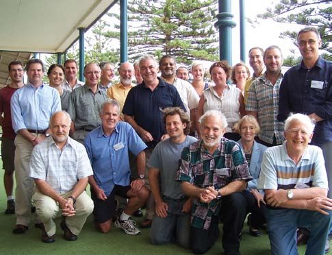
AATAMS survives                          Maria Island reference station is deployed

Cyclone Nicholas                         Drs Tim Lynch and Lindsay Pender, ably assisted by the deck crew of the
                                         RV Southern Surveyor, successfully deployed moored infrastructure for
In late 2007 and early 2008,             the National Reference Stations (NRS) on the 10 April 2008. Operating at
AATAMS (for more information about
                                         night, the sub surface component of the Maria Island NRS was placed
AATAMS see Marine Matters issue
                                         onto the seafloor at 42 35 .80S, 148 14.00E, which is the same location
3), in collaboration with CSIRO and
                                         where data has been collected from small boats since 1944.
AIMS, deployed nearly one hundred
acoustic receivers off Ningaloo Reef     Built by Danny McLaughlan and                and analysis after two months. This will
in Western Australia. The receivers      David Cherry from the Ocean Sensor           provide valuable information on the
were deployed as three curtains          Deployment Group (OSDG) at CMAR, the         rate of bio-fouling of the equipment,
from the coast to the 100 and 200 m      NRS mooring carried a sensor payload         the integrity of the data stream and
isobath off northern, southern and       of two Wetlabs Water Quality Monitors        the actual, as opposed to modelled,
mid Ningaloo Reef. These curtains        (WQM), one located near the bottom at        use of battery power. The next stage
detect all tagged fish migrating         90 metres and another in the euphotic        of the project is to deploy a surface
along the Ningaloo Reef coast. Three     zone at 20 metres. David Hughes, also        float to commence development of a
grid arrays of receivers were also       from OSDG, programmed the initial            telemetry stream from the WQMs. Team
deployed to investigate habitat use,     deployment of this new combination           members from the OSDG are currently
movements, and residence time of         sensor (conductivity, temperature,           finalising designs for a water proof
coral reef fishes, sharks, and rays.     pressure, salinity, oxygen, chlorophyll      telemetry canister which will become
                                         and turbidity) to test two different rates   the generic module for both future NRS
                                         of battery use.The mooring is set to         deployments and other programs.
                                         be recovered for data downloading

                                         eMII MEST workshops
                                         The eMarine Information Infrastructure       • Navigating around the MEST.;
                                         (eMII) Facility have run Metadata
                                                                                      • Searching the MEST;
                                         Entry and Search Tool (MEST)
                                         workshops in May, hosted at                  • Permissions and MEST behaviour;
                                         the Bureau of Meteorology and
                                                                                      • How to clone a “sample record” and
                                         the University of Tasmania.
                                                                                         amend the content to describe a
                                         The goal of the workshops was to                specific instance of an IMOS dataset;
                                         lead the data facilitators from each
                                                                                      • How to edit and delete data files;
                                         facility through the steps required to
Dr Charlie Huveneers, the AATAMS
                                         upload metadata and observational            • How to save and manage
Technical Officer, deploying an
acoustic receiver at Ningaloo Reef,      data to eMII, and to provide an                 permissions over a record;
WA. Photo courtesy of Frazer McGregor.   overview of user’s access to IMOS            • How to upload and download
                                         data over the internet using the MEST,          observational data files;
However, within days of the last         Presentations and hands-on experience
deployments, Cyclone Nicholas            at the workshop demonstrated:                • How to link related records.
travelled down the Ningaloo Reef
coast over the top of the curtains and
arrays. Luckily, AATAMS Technical
Officer Charlie Huveneers had the
opportunity to check on the majority     SST data to flow with new file servers
of the moorings and receivers after
                                         The Satellite Remote Sensing (SRS)           Meteorology. Work towards population
the cyclone had passed and all of
                                         Facility had two Sun X4500 40 terabyte       data arrays in Perth is underway and
the checked moorings were still
                                         file servers delivered in Melbourne          SRS should have MODIS data online
present at the deployed locations.
                                         and Canberra recently. Each system           in a few weeks. SRS will initially use
No damage could be seen.
                                         weighs 98 kilograms and has 48, one          the Canberra system to test AO-DAAC
This is great news for AATAMS            terabyte disk drives. It took four people    software components with some test
confirming that the mooring design is    to get the unit out of the box and           data before full deployment. SRS are
strong enough to withstand cyclonic      into the rack. Once the systems are          progressing with the software and the
winds. We are looking forward            configured, Sea Surface Temperature          installation of the OPeNDAP server
to recovering and downloading            (SST) data will start flowing to the         software which should follow quickly
data from the receivers in July.         Melbourne system from the Bureau of          once the systems are up and running.

2   marinematters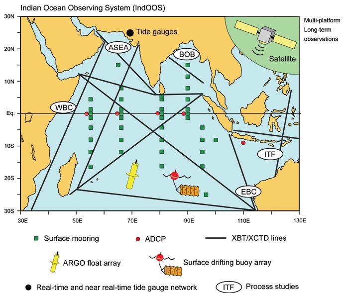
Annual Planning                                    Progress-highlight for each facility

Meeting                                            Bluewater and climate facilities          Coastal ecosystem facilities
                                                   Argo: The planned global coverage         FAIMMS: First test deployments are
The 2nd IMOS Annual Planning                       of 3000 floats was achieved and           now live and data is coming from these
Meeting was held on 18-20 February                 float-deployment in the IMOS              via a simplistic data management
at Glenelg, South Australia. There                 region is nearing completion              system; June 2008 sees the first major
were 34 participants including                                                               deployment at Heron and One-Tree
                                                   SOOP: First steps to change from
five Board members, node,                                                                    Islands with Rib Reef soon after;
                                                   a primarily physical oceanographic
facility and sub-facility leaders,                 network to a multidisciplinary network    AATAMS: Ningaloo acoustic
Operator contacts, IMOS Office                     to support research on the physical       screens installed in February and
and an invited speaker. The                        environment and ecosystems. Victoria      no lost instruments after tropical
invited speaker, Anne Fitzgerald                   state government is supporting            cyclone Nicholas went over.
from QUT Law Faculty, discussed                    instruments on the Bass Strait Ferries.
                                                                                             AUV: Completed deployments at
legal issues that arise in a free                  SOTS: A trial deployment of the           Jervis Bay, biodiversity assessment at
and open data environment. Nick                    biogeochemical mooring will               Ningaloo (supported by AIMS), drowned
D’Adamo presented an overview                      be subjected to engineering               reefs on GBR (Southern Surveyor)
of international ocean-observing                   analysis after recovery
                                                                                             Data management facilities
activities, particularly in the
                                                   Coastal currents and water
Intergovernmental Oceanographic                                                              SRS: High resolution (1-5km), real-
                                                   property facilities
Commission, as they relate to IMOS.                                                          time and re-processed SST maps
                                                   ANMN: 15 moorings in the                  are available in the IMOS region
The major part of the meeting                      water by June 2008
                                                                                             eMII: MEST is ready for IMOS data.
concerned reports on the current
                                                   ACORN: A radar system
status and plans out to June                                                                 In closing the meeting, Dr Trevor Powell,
                                                   operating off southern Qld and
2009 from the 11 facilities. It was                                                          the chair of the IMOS Advisory Board,
                                                   sites selected in WA and SA
encouraging to see how much                                                                  noted the progress, and how quickly it
progress has been achieved.                        ANFOG: 5 gliders delivered and            was achieved, given that subcontracts
                                                   full stable of 8 (5 Sea-gliders and 3     were completed much less than a
                                                   Slocums) expected by June 2008.           year ago. He noted that the emphasis
                                                                                             is changing now from the logistics of
                                                                                             getting started, to implementation and
                                                                                             engagement with the user community.
                                                                                             Dr John Gould, the international member
                                                                                             of the Advisory Board, commented that
                                                                                             IMOS is an ambitious and wide ranging
                                                                                             national effort, in many ways trail-
                                                                                             blazing for the international community.

                                                                                                Annual Business Plan
                                                                                                2008/09 to DIISR
                                                                                                Following on from the IMOS Annual
                                                                                                Planning Meeting in February, the
                                                                                                IMOS office with the Facility and
                                                                                                Sub-facility leaders, prepared their
                                                                                                plans for the 2008/09 financial
                                                                                                year. The Annual Business Plan
                                                                                                (ABP) was approved by the IMOS
                                                                                                Advisory Board and submitted to the
                                                                                                Department of Innovation, Industry,
                                                                                                Science and Research (DIISR) on
                                                                                                27th March 2008. We are currently
Annual Planning Meeting attendees (left to right): Standing: Dr Stefan Williams, Mr Craig       awaiting advice from DIISR that
Steinberg, Dr Moninya Roughan, Dr Nick D’Adamo, Prof Mal Heron, Prof Iain Suthers,              the ABP has been accepted.
Dr John Gould, Dr Peter Turner, Dr Peter Doherty, Prof Chari Pattiaratchi, Mr Simon
Allen, Dr Marian McGowen, Mrs Jo Neilson, Dr Susan Wijffels, Mr Scott Bainbridge,               If you would like a copy of the
Dr Rob Harcourt, Prof Craig Johnson. Sitting: Prof Richard Coleman, Mr Ken Ridgway,             2nd Annual Business Plan, please
Dr Eric Schulz, Prof Gary Meyers, Prof Jo Laybourn-Parry and Dr Trevor Powell.                  contact the IMOS office.

                                                                                                                    marinematters     3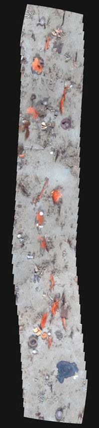
approach to infrastructure development
                                              be maintained. It has been more
corner
director’s

                                              effective for developing the marine
                                              observing system than the previous
                                              competitive grant schemes, and
                                              this is likely to be true for all aspects
                                              of environmental monitoring.
                                              Another point is that the marine
                                              observing system has to be largely a
                    Dr Gary Meyers            public service supported by public
                                              funding, like the weather service.
                                              This is because there are many
                                              activities and businesses in addition
Two ongoing major reviews
                                              to research that benefit from the same
initiated by the new Labour                   observations – e.g. fishing, tourism,
Government are highly relevant                search and rescue, shipping, port-
                                              management, offshore industries, etc
to IMOS – the Review of the
                                              – and the total investment is justified
National Innovation System                    by adding all of the relatively small
and the Review of the NCRIS                   benefits together. The onus then is
                                              placed back on the marine community
Roadmap. This newsletter is
                                              to develop the capability for innovative,
an opportunity to publically air              public services that will justify public
some of the ideas expressed                   funding. Of course, we have already
                                              been innovative: IMOS data is already
in the IMOS submissions.
                                              flowing into BLUElink (a hugely
                                              successful service jointly developed
Firstly, the national, strategic approach     by CSIRO, BoM and RAN during
to infrastructure-development, as             the past seven years, and running
implemented by NCRIS, was highly              operationally now at BoM). However,
effective for the marine community. We        much remains to be done to prove the
were ready for a national, community-         value of sustained marine observations
driven approach because many had              to all of the potential users. I suggested
worked hard for almost two decades to         in the submissions that we follow the
establish small parts of the observing        lead of Europe’s Global Monitoring
system, always knowing that more is           for Environment and Security, a new
required to support research on the           multinational organisation whose
role of the ocean in the climate system,      primary purpose is to develop highly
human (including climate) impacts on          innovative applications of earth
marine ecosystems and conservation            observations. This is not the place
of marine biodiversity. The strategy for      to describe GMES in detail, but if
the observing system was embodied             you Google it you’ll see that it is a
in Australia’s Oceans Policy (1998)           potentially useful strategic approach.
and the associated Marine Science
                                              Finally, there is a need to sustain
and Technology (MS&T) Plan (1999).
                                              IMOS beyond the current investment,
The documents clearly articulated
                                              to maintain the long-term monitoring
the strategic approach. After these
                                              capability required to support marine
efforts, many in the marine community
                                              and climate research and applications.
were ready to take advantage of
                                              The long term development needs to
NCRIS facilitated process, and ready
                                              be based on staged increments, where
to make the compromises required
                                              the observing system at each stage is
for a community plan. A long time
                                              re-assessed against priorities that are
has passed since the MS&T Plan was                                                         A sample mosaic from the Autonomous
                                              broadly accepted by the developers           Underwater Vehicle (AUV) taken
published. For the researchers who
                                              and the users. But re-assessment             at Ningaloo marine park, Western
contributed to writing it, it is worthwhile
                                              should not preclude a long term              Australia showing sponge beds in 80m
now to go back and have a read.
                                              commitment to investment in marine           of water. The AUV was maintaining an
As a community, we strongly                   observations by the Government.              altitude of 2m, giving a 1.5m swath,
recommend that the national, strategic                                                     and traveling at 0.5m/s. The mosaic is
                                                                                           composed of 40 images captured at
                                                                                           2Hz and represents a 10m transect.
4   marinematters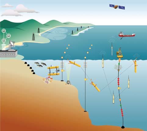
Facility Feature Article #4
                                                                                           By Wilbur Longbottom & Marian McGowen
Ships of Opportunity – Mr Ken Ridgeway

The measurement of ocean temperature has a long dependence on volunteer observing
ships, with original instrumentation consisting of a bucket and thermometer. Sampling
techniques have progressed with advances in technology in the latter half of the 20th
century, enabling the collection of data from participating merchant vessels and cruise
liners (Ships of Opportunity, SOOP). Until recently, researchers have collected only
sea temperature and physical data; however, IMOS is currently upgrading the SOOP
program in Australia to enable a broader, multidisciplinary suite of data collection.

A Brief history                             needed in the east central and west          Ocean, the shelf seas across northern
                                            Pacific, as well as in the middle of the     Australia, and the Great Barrier Reef.
One of the first oceanographic
                                            ocean. The XBT network was extended          A number of organisations have made
variables measured was sea surface
                                            across the Indian Ocean in the mid           significant co-investments into the
temperature (SST). In an effort to
                                            1980s with Gary Meyers’ move to              SOOP facility, including the Australian
understand the Gulf Stream, Benjamin
                                            CSIRO in Australia, where he helped          Climate Change Science Program,
Franklin measured SST over 200 years
                                            to establish a consistent data stream        Antarctic Climate and Ecosystems
ago using a simple mercury-in-glass
                                            from merchant ships around Australia.        CRC, Australian Government Antarctic
thermometer suspended over
                                            The data generated by these XBT              Division, Australian Institute of Marine
the side of his ship during
                                            lines is currently sent in near real-time    Science, Bureau of Meteorology,
the voyage between the
                                            to climate analysis centres around           CSIRO, Marine National Facility, Royal
US and Europe. Although
                                            the world where it is routinely used in      Australian Navy and Scripps Institute of
improvements to thermometers
                                            models for seasonal climate prediction.      Oceanography. Although the framework
subsequently increased
                                            This data set is invaluable for examining    of SOOP has been established by
precision, measurements
                                            climate variability and change in the        IMOS new participating agencies
were still constrained to
                                            ocean as some records now go back            can add observations tailored to their
individual water depths. With
                                            over 25 years. At least 44 publications      needs. For example, the Environment
the invention of the mechanical
                                            in refereed scientific journals have used    Protection Authority Victoria has
bathythermograph (a torpedo-
                                            the Australian XBT data, not to mention      recently funded the installation of an
like device about the size of a
                                      XBT   many more using the global SOOP data.        autonomous marine sensor package
water bottle, attached to a line
                                                                                         onto the ferry, Spirit of Tasmania 2, on
and thrown over the side of a ship) by
                                            Enhanced Measurements from                   its Bass Strait route. Through joining
Athelstan Spilhaus in 1937, it became
                                            Ships of Opportunity (SOOP)                  IMOS they have been incorporated
possible to make a continuous record
                                                                                         into the national SOOP network.
of temperature versus depth. The            Ken Ridgway, a researcher at CSIRO
development of thermistors, electronic      Marine and Atmospheric Research and          Enhanced SOOP is coordinated with
devices to measure temperature, led         the SOOP Facility Leader, is currently       the merchant ship programs in other
to the expendable bathythermograph          upgrading SOOP within IMOS. This             countries through the intergovernmental
(XBT) in the 1960’s, originally designed    evolution will lead to a multidisciplinary   Joint Committee on Oceanography
for use in submarine warfare.               set of integrated, repeat underway           and Marine Meteorology (http://www.
Oceanographer Ray Montgomery                observing systems on volunteer ships         jcommops.org). The international
recognised the potential for XBTs in        in Australian regional seas, linking         program provides global coverage of
ocean research and initiated what was       physical, chemical and biological            oceanic thermal structure. IMOS is one
to become the modern SOOP program,          oceanography. The observations               of the first to enhance the XBT ships
installing XBTs on the cruise liner that    will span spatial scales from eddies         with biogeochemical observations.
operated between Honolulu, Tahiti           to basin width, and timescales from          Enhanced SOOP also participates
and Samoa to monitor the equatorial         seasonal to decadal. The enhanced            in international research programs
current system of the Central Pacific.      SOOP facility will generate time-series      such as the Southwest Pacific Ocean
                                            data in areas that have only sparse,         Circulation and Climate Experiment
When researchers Jean-René Donguy
                                            discontinuous biological data in             (SPICE). SPICE aims to understand
and Gary Meyers began studying
                                            the past. Target regions include the         the role of the Southwest Pacific in the
the El Niño – Southern Oscillation
                                            boundary current systems off Eastern         transmission of decadal climate signal
phenomenon in the 1970’s, they
                                            and Western Australia, the Southern          to the equatorial and Tasman region.
realised that XBT transects were

                                                                                                               marinematters    5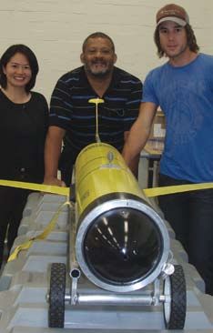
The SOOP program within IMOS                     enhanced this sub-facility to include                      transmitting data by GPS Tracking
         is divided into 4 sub-facilities                 an autonomous marine monitoring                            System (GTS) every 1-3 hours. The
                                                          system on the Spirit of Tasmania 2.                        data collected will be used to validate
         Multidisciplinary Underway Network
                                                          The sensors will record temperature,                       environmental satellite instruments and
         CSIRO Marine and Atmospheric                     salinity, chlorophyll-a and turbidity.                     contribute to the routine mapping of
         Research (CMAR) will operate the                                                                            SST. BoM (in partnership with AIMS
                                                          Sensors on Tropical Research Vessels
         network, using commercial shipping lines                                                                    and CMAR) will install a near real-
         to add biogeochemical observations to            The Australian Institute of Marine                         time thermosalinograph system on
         the existing XBT lines. This will improve        Science (AIMS) will increase its                           the Gladstone to Heron Island Ferry.
         coverage, enabling researchers to                monitoring of the Great Barrier Reef and
                                                                                                                     Research Vessels Real-
         monitor the transport of mass, heat and          the western Coral Sea. Research vessels
                                                                                                                     Time Air-Sea Fluxes
         freshwater in Australia’s major boundary         Cape Ferguson and Solander will be
         currents and their relation to ecosystems.       upgraded to include thermosalinograph                      SOOP will install sensors on RV
         Biogeochemical sensors will be added             and chlorophyll sensors, with the                          Southern Surveyor and RV Aurora
         to the National Marine Research Facility,        total suite of sensors able to record                      Australis to produce high quality, real-
         RV Southern Surveyor to monitor the              temperature, salinity, fluorescence,                       time measurements of air sea fluxes
         sensitivity of biogeochemical cycling to         light absorption and irradiance.                           (the transfer of heat and freshwater
         climate change, and to measure CO2               These research vessels will undertake                      between the atmosphere and the sea).
         uptake in critical areas. Continuous             repeated transects in the target areas                     Improved knowledge and mapping
         Plankton Recorder (CPR) devices,                 as well as individual cruise tracks.                       of air-sea fluxes is one of the great
         capable of recording species-level data                                                                     challenges of climate research. This
                                                          Sea Surface Temperature (SST)
         of phytoplankton and zooplankton, will                                                                      sub-facility will obtain data for study
                                                          Sensors for Australian Vessels
         be installed on two lines to establish links                                                                of the role of the ocean on climate
         between planktonic ecosystem structure           This sub-facility of SOOP, in collaboration                variability, carbon levels, ecosystems
         and large-scale physical variability. One        with the Bureau of Meteorology (BoM),                      and coastal environments.
         line will run down the core of the East          will improve validation of SST data
         Australia Current and the second across          gathered by satellite by equipping eight
         the Southern Ocean to Antarctica. The            to ten Australian Volunteer Observing
         State Government of Victoria recently            Ships with hull-mounted SST sensors

         SOOP Observation plan out to June 2009.
     0
                                                                                 Ships of Opportunity:
                                                                                       XBT (temperature)
10                                                                                     CO2
                                                                                       Plankton
                                                                                       Air Sea Fluxes
20
                                                                                      Temperature, Salinity,
                                                                                      Chlorophyll, Fluorescence,
                                                                                      Light absorbtion, Irradiance

30                                                                                    AVOF SST coverage

                                                                                                                     © Stevie Davenport, Australian Antarctic Division

40

50

60

70
     90        100    110     120    130    140     150     160     170    180

                                                                                                                                                   © Australian Antarctic Division
         The shipping routes that will provide the observational data
         streams for SOOP. Navy blue lines are XBT (temperature)
         transects; the red lines are CO2 transects to measure the CO2
         uptake in critical areas; green lines are plankton transects and                  The Continuous Plankton Recorder (CPR) is a device that
         will collect abundance and species data with CPR’s; aqua blue                     is trailed behind a vessel to record quantity and genera of
         lines are air sea flux transects that will measure the transfer of                plankton in the water in long transects. The microscopic
         heat and freshwater between the atmosphere and the ocean;                         plankton enters the device and is trapped on a silk that
         and pink lines represent the routes of the upgraded Research                      is continuously wound. The silk is then put under a
         vessels Cape Ferguson and Solander. The area covered                              microscope and the abundance of the different types of
         by the Australian Volunteer Observing Ships (AVOF) for                            plankton is measured. CPR surveys allow researchers to
         measuring Sea Surface Temperature (SST) is shaded yellow.                         observe changes in distribution, abundance and phenology.

         6   marinematters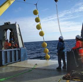
Cooperation with                              observers and providing high quality data
shipping companies                            for SOOP. The SOOP program, with their
                                              crew of volunteers on existing commercial
The strength of the SOOP facility lies
                                              shipping lines, provides a cost-effective
in the cooperative efforts of marine
                                              means of obtaining reliable and accurate
scientists and commercial shipping
                                              time-series data across the oceans.
companies to collect data of increasing
sophistication and breadth, thereby           The enhancements to SOOP, funded
increasing our knowledge of ocean             through IMOS, will provide long-
currents and climate, which ultimately        term ocean observations that are
returns benefits to both shipping             vital to understanding the influences
companies and the wider community.            responsible for changes and variability
The SOOP team has developed a                 in Australia’s climate system, and could
rapport with volunteer observers from         even help predict the effects of climate
the commercial shipping companies             events such as the El Niño – Southern       “The ships companies might benefit
ensuring they feel involved in the project.   Oscillation phenomenon. Increasing          in the long term from the improved
Marine scientists provide training on how     our understanding of the ocean              knowledge of ocean current and
to collect the data at sea, encourage         and climate is not only important for       climate, but for the most part
interest in what the data will be used for,   merchant shipping, fisheries, national      they undertake it as a community
                                              defense, and the public, but has the        service,” says Mr Ken Ridgway.
and provide feedback on the findings.
Conversely, the volunteers welcome the        potential to improve planning and
distraction of collecting data whilst at      management of significant sectors           For more information, please contact:
sea, and are usually very interested in the   of the Australian economy, such as          Mr Ken Ridgway
research being done, becoming excellent       agriculture, energy and resources.          Ken.Ridgway@csiro.au

                                                                                            Facility Feature Article #5

Ocean Gliders – Professor Chari Pattiaratchi                                                By Wilbur Longbottom & Marian McGowen

Oceanographers have traditionally used ships to observe the oceans, however, the high
cost of ship time restricts the size of the area covered and makes repeated surveys over a
particular area uneconomic. Underwater ocean gliders represent a technological revolution
for oceanography. Autonomous ocean gliders can be built relatively cheaply, are controlled
remotely and are reusable; allowing them to make repeated subsurface ocean observations
at a fraction of the cost of conventional methods. The Australian National Facility for
Ocean Gliders (ANFOG), with IMOS/NCRIS funding, will deploy a fleet of eight gliders
this year. The data retrieved from the glider fleet will contribute to the study of the major
boundary current systems surrounding Australia and their links to coastal ecosystems.

Realising a vision                            transmit via satellite their accumulated    unlike Argo floats that drift in the ocean
                                              data and receive instructions telling       currents, gliders have wings and a
Henry Stommel, a renowned physical
                                              them how to steer through the ocean”.       rudder to allow them to move horizontally
oceanographer, published a visionary
                                              Ocean gliders have undergone a              in a selected direction while profiling
article in the journal Oceanography
                                              steady development in the 20 years          across strong currents. Essentially this
in 1989, written from the perspective
                                              since Stommel’s article, making the         means that the gliders’ horizontal position
of an oceanographer reminiscing in
                                              transition from fantasy to reality.         is controllable, and allows researchers
2021. He described a world ocean
                                                                                          to decide where the glider goes. Global
observing system based on “a fleet of         Ocean gliders propel themselves by
                                                                                          low-power satellite communication is
small neutrally buoyant floats called         changing buoyancy, they alternately
                                                                                          a key enabling technology for gliders,
Slocums”. The floats would “migrate           reduce and expand their volume to dive
                                                                                          making it possible for them to be
vertically through the ocean changing         and climb through the ocean, in the
                                                                                          remotely controlled world-wide and for
ballast…steered horizontally by gliding       same way as Argo profiling floats (see
                                                                                          the transfer of near real-time data.
on wings…broaching the surface to             Marine Matters issue two). However,

                                                                                                                  marinematters    7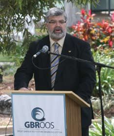
Ocean glider Fact File                 Slocum glider                Seaglider                 also use a Slocum glider to investigate
                                                                                              the challenging environment of the
                                                                                              continental shelf off Stockton Bight,
                                                                                              Jervis Bay and Eden. The Slocum glider
Type                                   Coastal                      Open ocean                will sample recurrent features during 3
                                                                                              week deployments, such as tracking the
Depth range                            5-200m                       Up to 1000m
                                                                                              maturation of phytoplankton after a cold
Maximum Range                          500km                        4600km                    core eddy brings nutrients into the photic
Speed                                  40cm/s                       25cm/s                    zone. The inshore monitoring will also
Deployment time                        30 days                      6 months                  track the effects of estuarine discharge
                                                                                              and southern extensions of the isotherms
                                                                                              off Eden. These Slocum deployments
ANFOG’s glider fleet                            cost and duration of their deployment
                                                                                              will complement zooplankton sampling
                                                will vastly improve the amount of data
The IMOS glider fleet will consist                                                            from the RV Southern Surveyor.
                                                oceanographers are able to collect. Also
of two types; Slocum gliders and
                                                gliders will collect data during periods
Seagliders. Slocum gliders (named
                                                of extreme weather conditions. “Usually
for Joshua Slocum the first solo global
                                                we go on a ship to obtain data – this is
circumnavigator) and manufactured by
                                                very expensive and limited to when the
Webb Research Corp are optimised
                                                weather is suitable and the availability
for shallow coastal waters (< 200m)
                                                of a ship – but gliders will collect data
where high manoeuvrability is needed.
                                                under any weather conditions at a
ANFOG will have three Slocum gliders
                                                fraction of the cost. Gliders will enable
to be deployed on the continental shelf.
                                                sustained ocean observations,” he says.
Seagliders, built at the University of
Washington, are designed to operate             Sustained ocean observations will allow
most efficiently in the open ocean up           researchers to document the natural
to 1000m water depth. ANFOG will                variability of the ocean, and better
use their five Seagliders to monitor            understand the effect of climate change
the boundary currents surrounding               on coastal ecosystems.The IMOS gliders
Australia. The Seagliders can be used           will focus particularly on the major
to conduct repeated glider surveys              boundary currents that run down the
                                                                                              SeaGlider (blue) samples EAC
across the boundary currents and                Australian coast, the Leeuwin in the west     and then warm core eddy.Slocum
continental shelves, which is valuable          and the East Australian Current (EAC).        glider (yellow) has a similar track
for gathering long-term environmental           The study of these currents is critical for   through a cold core eddy.
records of physical, chemical and               understanding the north-south transport
biological data not widely measured to          of freshwater, heat and biogeochemical        Bluewater and climate – Monitoring
date. Whilst the Slocum gliders, due to         properties. The currents exert a large        the Southward extension of
their low cost and operational flexibility,     influence on coastal ecosystems,              the East Australian Current
will be of great use in intensive coastal       shipping lanes and fisheries.
                                                                                              The Bluewater node will use a Seaglider
monitoring, both types of glider weigh
                                                                                              to complete glider tracks to monitor
only 50kg enabling them to be launched          IMOS Glider projects
                                                                                              the flow of the EAC off Tasmania. The
from small boats. They will have the
                                                Following a public Call for Proposals         glider transect will provide the first
same suite of sensors, able to record
                                                in 2007 for the IMOS infrastructure the       extended time-series of the absolute
temperature, salinity, dissolved oxygen,
                                                ocean gliders have been allocated to          transport of the EAC. Climate modelling
turbidity, dissolved organic matter and
                                                four projects which will be coordinated       and sparse historical data suggest that
chlorophyll against position and depth.
                                                by research teams at four of the              the EAC is spreading southward over
The key feature that sets ocean gliders         IMOS Science nodes; NSW-IMOS,                 decades and affecting the temperate
apart from other autonomous underwater          Bluewater, SAIMOS and WAIMOS.                 marine ecosystem. The Seaglider
vehicles is that they are slow. Slocum                                                        will begin monitoring this process in
                                                NSW-IMOS – Exploring hydrography
gliders cruise at a maximum speed of                                                          a systematic way. The data obtained
                                                and fluorescence in the EAC, its
only 40cm/s, whilst Seagliders cruise at                                                      from the Seaglider will compliment
                                                eddy field and in the Tasman Front
24cm/s. This slow speed and consequent                                                        other data streams from Argo, XBT
low drag permit long deployments                NSW-IMOS will deploy one Seaglider            transects, satellite altimetry and Sea
of up to 6 months. Professor Chari              for 6 month deployments in the Tasman         Surface Temperature, and further
Pattiaratchi, the leader of ANFOG, and          Sea, to obtain physical and biological        develop general ocean observing
the Coastal Oceanography Group at               properties in order to improve the            techniques and algorithms, assimilated
the University of Western Australia,            understanding of the dynamics and             into ocean models to provide a
notes that although the data collected          variability of the EAC, the Tasman Front,     detailed description of the EAC flow.
by the gliders will not be unique, the low      and eddies shed by the EAC. They will

8   marinematters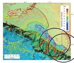
productive boundary currents off the       Future of oceanography
                                             west coasts of Africa and the Americas
                                                                                        Ocean gliders present new
                                             is nutrient depleted. Originating in
                                                                                        opportunities for studying the oceans
                                             the tropics, the Leeuwin current is a
                                                                                        surrounding Australia. With these
                                             shallow, narrow band of warm, low
                                                                                        glider projects, ANFOG will develop
                                             salinity water, which flows poleward
                                                                                        strategies and techniques to use
                                             from Exmouth to Cape Leeuwin and into
                                                                                        gliders in sustained ocean observing
                                             the Great Australian Bight. The Slocum
                                                                                        to best advantage. These projects will
                                             glider will complete circuits from Two
                                                                                        also build technical capability in the
                                             Rocks (north of Perth) to the edge of
                                                                                        IMOS nodes around the country, and
                                             the Leeuwin Current and then return
                                                                                        transfer skills needed in the operation
                                             through the axis of the Perth Canyon. A
                                                                                        of ocean gliders. Ocean observing
                                             Seaglider will be released off Dampier
                                                                                        will always present a challenge to
The February Sea Surface                     every 3 months and will traverse back
                                                                                        researchers, with the wide range of
temperature around Tasmania.The              and forth across the Leeuwin Current,
Seaglider track is shown in blue.                                                       time and space scales that need
                                             completing its deployment in Freemantle.
                                                                                        to be resolved. Whilst ships and
SAIMOS – Boundary and Shelf                                                             moorings will remain important for
Currents: exchange with the                                                             oceanography, Stommel’s vision of a
shelves of SA and Victoria                                                              network of ocean gliders will provide
                                                                                        the best way to obtain sustained spatial
SAIMOS will use a Seaglider to explore and                                              sampling of the sub-surface ocean.
map the deep boundary currents between
the Eyre Peninsula and the western
mouth of Bass Strait, at present largely
unknown, and identify hot spots for deep
ocean exchange with the shelf, between
SA and Tasmania. A Slocum glider will
also be used to investigate the shelf and
shelf break exchange and currents of
the SA upwelling zone and Bonney Coast
and western mouth of Bass Strait.

                                             Proposed Slocum glider track
                                             along Two Rocks transect returning
                                             through the Perth Canyon.

Upwelling off the Bonney Coast
during March 1995 as illustrated                                                        The ANFOG team, Mun Woo,
by SST. The red line denotes                                                            Chari Pattiaratchi and Ben
a possible Seaglider path.                                                              Hollings, with a Slocum glider.

WAIMOS – Deployment of ocean
gliders in Western Australia
as part of the WAIMOS
WAIMOS will use two Seagliders and
one Slocum glider to continue ongoing
research efforts to understand the role of
the Leeuwin current system in controlling
                                             Proposed Seaglider deployment
not only the marine life but also the                                                   For more information, please contact:
                                             off Western Australia. The glider
climate of south-western Australia. The                                                 Prof Chari Pattiaratchi
                                             will be released off Dampier and
Leeuwin current, in contrast to the highly   recovered at Freemantle.                   chari.pattiaratchi@uwa.edu.au

                                                                                                                marinematters   9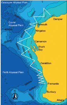
IMOS PhD Student Profile
Students using IMOS data for their PhD research
Paul Durack Project Title: Oceanic influence on the global
Quantitative Marine Science hydrological cycle: Quantifying the global salinity
(QMS) Program cycle - Ocean-atmosphere freshwater fluxes
CSIRO and University of Tasmania
Paul’s PhD project is focused on looking at Paul’s project is dependent on the new Argo
changes to observed ocean salinity through data array, in fact, without this great new data
time. The available historical data covers the resource, he’d be unable to look at global
period from 1874 to 2005, however around changes in the 4 key ocean basins due to
20% of more recent data is provided by Argo the sparseness of historical ocean data both
floats with good spatial coverage beginning in time and space. This new data resource
around 2002 from this platform. Change has enabled Paul and his colleagues to get a
in salinity is an indication of the global much better idea of what is happening in the
hydrological cycle, because ocean salinity global oceans, providing complete coverage
is a consequence of the difference between throughout the seasonal and annual cycle. At
rainfall and evaporation at the sea surface. last count 3110 active floats (and counting..)
As part of Paul’s PhD, he was invited
The rate of global climate change – which is a make up the array, with the original operational
to take part on the last voyage of the
very important scientific and political question target being 3000, so it’s at full capacity and
INSTANT program, during which he
- can be monitored by tracking salinity. giving oceanographers some incredible new
was involved in Argo deployment
insights to the workings of the global oceans..
Paul started his scientific life back last in Indonesia’s Banda Sea.
Along with historical data from ships and
century, completing his undergraduate
moorings back to the 1950’s, and the existing
studies in Western Australia, before heading
coverage of ocean surface and atmospheric
to Melbourne to work at the CSIRO labs
flux data, Argo is providing answers to
in Aspendale. He started his PhD in the
many ocean-related questions, including For more information:
CSIRO and UTas QMS program in 2006, and
the sustained monitoring of ocean salinity. Contact Paul Durack; paul.durack@csiro.au
is working under supervision from Susan
Wijffels (leader of the IMOS Argo Facility),
Nathan Bindoff, Helen Phillips and Richard
Coleman – quite the dynamic team!
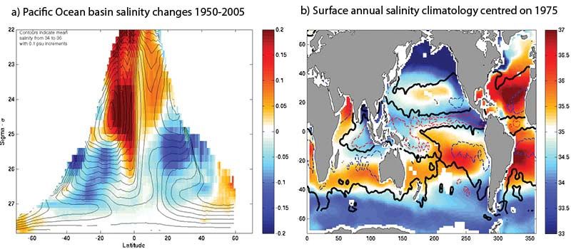
This figure expresses (a) integrated changes to the Pacific Ocean basin salinity
from 1950-2005 and (b) an annual surface ocean salinity climatology (right)
centred on 1975; generated from a collection of varied data products; including
over 330,000 Argo data profiles (Contours show regions of maximum evaporation
(blue) and precipitation (red) with the transition zone indicated in black).
10 marinemattersIndian Ocean Observing System (IndOOS)
The Indian Ocean is unique Recurrence of these monsoon rains is The World Climate Research Programme
among the three tropical ocean critical to agricultural production that (CLIVAR) www.clivar.org/organization/
provides life-sustaining support for half indian/IndOOS/timeseries.php and the
basins in that it’s western
the world’s population. However, the Intergovernmental Oceanographic
boundary current is blocked at annual cycle of the Indian Ocean is not commission are working to design and
25°N by the Asian land mass, sufficiently repeatable to avoid variations implement an integrated observing
and the Indonesian Throughflow of climate from year to year. The Indian system for the Indian Ocean, including
Ocean remotely influences the evolution a basin-wide mooring array, a 3°x3°
is an additional source of heat.
of El Niño and the Southern Oscillation array of Argo floats, a 5°x5° array
Seasonal heating of the land sets (ENSO), the North Atlantic Oscillation of surface drifters, an enhanced
the stage for dramatic monsoon (NAO), North American weather, XBT network as well as many other
wind reversals, strong ocean- Atlantic hurricane formation, and most measurements (e.g., process studies,
importantly for us, the seasonal climate tide gauges and satellites).
atmosphere interactions and
of Australia. Despite the importance of
intense seasonal rains over the Visit the above webpage to see
the Indian Ocean in the regional and
what has already been implemented
Indian subcontinent, Southeast global climate system though, it is the
in the basin-scale Indian Ocean
Asia, East Africa, and Australia. most poorly observed and least well
Observing System (IndOOS).
understood of the three tropical oceans.
marinematters 11For more information about
IMOS please visit the website
www.imos.org.au
General enquiries:
Integrated Marine Observing
System (IMOS)
University of Tasmania
Private Bag 110
Hobart, TAS, 7001
+61 (03) 6226 7505 T
+61 (03) 6226 2107 F
imos@imos.org.au
Director
Professor Gary Meyers
Gary.Meyers@imos.org.au
Executive Officer
Mrs Jo Neilson
Jo.Neilson@imos.org.au
Executive Assistant
Dr. Marian McGowen
Marian.McGowen@utas.edu.au
Technical Director
Mr Simon Allen
Simon.Allen@csiro.au
Diagram illustrating how the national IMOS program works. IMOS integrates
Facility Leaders:
several independent technologies and instruments, ranging from moored sensors
Argo Australia
and deep sea autonomous floats to acoustic tracking devices, radar imagery and
Dr Susan Wijffels
remote satellites, among others, into research infrastructure covering a vast swath
susan.wijffels@csiro.au
of Australia’s large coastal and deep water marine territory. IMOS will generate
Enhanced Measurements from critical data needed to support a diverse range of marine research projects.
Ships of Opportuniity (SOOP)
Mr Ken Ridgway
Ken.Ridgway@csiro.au Australian Coastal Ocean Node Leaders:
Radar Network (ACORN)
Southern Ocean Automated Time Blue water and climate
Prof Mal Heron
Series Observations (SOTS) Mr Ken Ridgway
mal.heron@jcu.edu.au
Dr Eric Schulz Ken.Ridgway@csiro.au
E.Schulz@bom.gov.au Australian Acoustic Tagging and
Great Barrier Reef Ocean
Dr Tom Trull Monitoring System (AATAMS)
Observing System (GBROOS)
Tom.Trull@utas.edu.au Dr Rob Harcourt
Dr Peter Doherty
rharcour@gse.mq.edu.au
Australian National Facility for p.doherty@aims.gov.au
Ocean Gliders (ANFOG) Facility for Automated Intelligent
New South Wales IMOS (NSW-IMOS)
Prof Charitha Pattiaratchi Monitoring of Marine Systems (FAIMMS)
Prof Iain Suthers
chari.pattiaratchi@uwa.edu.au Mr Scott Bainbridge
i.suthers@unsw.edu.au
s.bainbridge@aims.gov.au
Autonomous Underwater
Southern Australia IMOS (SAIMOS)
Vehicle Facility (AUV) eMarine Information Infrastructure (eMII)
Dr Laurent Seuront
Dr Stefan Williams Prof Craig Johnson
Laurent.Seuront@flinders.edu.au
stefanw@acfr.usyd.edu.au Craig.Johnson@utas.edu.au
Western Australia IMOS (WAIMOS)
Australian National Mooring Network Satellite Remote Sensing (SRS)
Prof Charitha Pattiaratchi
Mr Simon Allen Dr Peter Turner
chari.pattiaratchi@uwa.edu.au
Simon.Allen@csiro.au Peter.Turner@csiro.au
IMOS is an initiative of the Australian Government being conducted as part of the National Collaborative Research Infrastructure Strategy
www.ncris.dest.gov.au/capabilities/integrated_marine_observing_system.htm
This issue of marine matters has been compiled by Dr Marian McGowen.
12 marinemattersYou can also read