Multihazard Risk Assessment for Planning with Climate in the Dosso Region, Niger - Semantic Scholar
←
→
Page content transcription
If your browser does not render page correctly, please read the page content below
climate
Article
Multihazard Risk Assessment for Planning with
Climate in the Dosso Region, Niger
Maurizio Tiepolo 1, *       ID
                                 , Maurizio Bacci 1,2   ID
                                                             and Sarah Braccio 1
 1    Interuniversity Department of Regional and Urban Studies and Planning (DIST), Politecnico and University
      of Turin, Viale G. Mattioli 39, 10125 Torino, Italy; maurizio.bacci@polito.it or m.bacci@ibimet.cnr.it (M.B.);
      sarah.braccio@polito.it (S.B.)
 2    Ibimet CNR, Via G. Caproni 8, 50145 Florence, Italy
 *    Correspondence: maurizio.tiepolo@polito.it; Tel.: +39-011-090-7491

 Received: 13 July 2018; Accepted: 6 August 2018; Published: 8 August 2018

 Abstract: International aid for climate change adaptation in West Africa is increasing exponentially,
 but our understanding of hydroclimatic risks is not keeping pace with that increase. The aim
 of this article is to develop a multihazard risk assessment on a regional scale based on existing
 information that can be repeated over time and space and that will be useful during decision-making
 processes. This assessment was conducted in Dosso (Niger), the region most hit by flooding in the
 country, with the highest hydroclimatic risk in West Africa. The assessment characterizes the climate,
 identifies hazards, and analyzes multihazard risk over the 2011–2017 period for each of the region’s
 43 municipalities. Hazards and risk level are compared to the intervention areas and actions of
 6 municipal development plans and 12 adaptation and resilience projects. Over the past seven years,
 heavy precipitation and dry spells in the Dosso region have been more frequent than during the
 previous 30-year period. As many as 606 settlements have been repeatedly hit and 15 municipalities
 are classified as being at elevated-to-severe multihazard risk. The geographical distribution of the
 adaptation and resilience projects does not reflect the risk level. A third of the local development
 plans examined propose actions that are inconsistent with the main hydroclimatic threats.

 Keywords: risk analysis; drought; fluvial flood; pluvial flood; loss and damage; climate adaptation
 projects; local development plans; West Africa

1. Introduction
     The Sendai Framework for disaster risk reduction [1] and the Sustainable Development Goals [2]
recommend that more efforts should be made to carry out risk analysis with a holistic vision.
This should orient a new generation of plans and projects towards communities that are most at risk,
towards the main hydroclimatic threats, and should help monitoring, evaluation, communication [3],
and awareness-raising activities [4]. In this article, with the term “risk”, we mean “the combination of
the probability of an event and its negative consequence” [5]. In the Global South, the multihazard
approach is increasingly included in risk reduction plans [6] and in publications addressing risk
on a local [7–13] and regional [14–18] scale. Nevertheless, the cases in which this approach has
been used up to now reveal the difficulty of applying multihazard risk assessment methods and
techniques that have been fine-tuned for countries boasting all the information and local expertise
necessary [19–23] to areas that lack these characteristics. West Africa is a typical case. In this vast
region, widespread warming, an increase in both the intensity and frequency of extreme heat waves,
and heavy precipitation events [24–29] were combined with an increase in the number of hydroclimatic
disasters [30] during the 1990–2010 period. The impact was catastrophic, considering the region’s
high reliance on rain-fed agriculture [31] and transhumant pastoralism. In the six years that followed,

Climate 2018, 6, 67; doi:10.3390/cli6030067                                          www.mdpi.com/journal/climate
Climate 2018, 6, 67                                                                                                         2 of 29

international aid earmarked $7.3 billion for creating 715 climate change (CC) adaptation projects in West
Africa’s 17 countries [32]. These projects mainly operate on a local scale (districts and municipalities)
and function alongside those that each individual country is already implementing with its own
resources. Despite the fact that the terms “climate adaptation” and “resilience” constantly appear in
these projects, the definition and location of actions cannot yet take advantage of either climate analysis,
risk mapping [33], or disaster databases on a regional scale [34]. For example, subnational risk mapping
lacks detail [35–38] and is mainly limited to floods. Multihazard risk is rarely taken into consideration.
Risk is calculated using indicators that do not represent risk factors. The techniques involved are still
too complex to be used at a local level or reproduced over time and space [39–53] (Table 1).

                Table 1. Seventeen analyses on hydroclimatic risk in West Africa, 2005–2017 [39–53].

         Region            Country ISO      Area Km2      Determinants of Risk *      Hazard         Technique        Reference
  Dassari **                  BEN                                  HV              Flood/drought     Risk Index          [39]
  Dano **                     BFA                                  HV              Flood/drought     Risk Index          [39]
  Vea **                      GHA                                  HV              Flood/drought     Risk Index          [39]
  Adamaua state               NIG                -                  V                 Flood        Spatial analysis      [40]
  Mono river basin            TOG              406                HEVA                Flood          Risk Index          [41]
  Mbo                         NIG              700                 HV              Flood/erosion   Spatial analysis      [42]
  Sinfra department           CDI              1600                HV                2 Floods      Spatial analysis      [43]
  Abidjan district            CDI              2119                HV                 Flood        Spatial analysis      [44]
  Edu local government        NIG              2542                 E                 Flood        Spatial analysis      [45]
  Ouémé basin                 BEN                -                 H                  Flood              SPI             [46]
  Benin Niger basin           BEN              9118               HEV                 Flood        Spatial analysis      [47]
  Man area                    CDI             12,100               HV                 Flood        Spatial analysis      [48]
  Sota basin                  BEN             13,410               HV                 Flood         Multicriteria        [49]
  Niger-Benoué basin          NIG             13,702                E                 Flood        Spatial analysis      [50]
  5 districts                 GHA             14,600               HV              Flood/drought     Risk Index          [51]
  Oti river basin             BEN             58,670              HEVA                Flood          Risk Index          [52]
  Tillabéri                   NER             97,250              HEV                 Flood          Risk Index          [53]
      * V-Vulnerability; E-Exposure; HV-Hazard, Vulnerability; HEV-Hazard, Exposure, Vulnerability; HEVA–Hazard,
      Exposure, Vulnerability, Adaptation. ** The reference [39] identifies three study areas in three West African countries
      which have similar climates and are under varying forms of agricultural systems.

       The goal of this article is to propose a multihazard risk assessment on a regional scale that will
be useful during decision-making processes and that can be updated over time by personnel lacking
advanced skills.
       The achievement of this goal raises issues concerning (i) the characterization of hydroclimatic
threats at regional level, (ii) the representation of the risk level according to administrative jurisdictions,
(iii) the pertinence of risk reduction policies to climatic threats, and (iv) the setting up of the assessment
in such a way that it can be repeated.
       The assessment was carried out in the Dosso region (31,000 km2 , with a population of 2 million)
of Niger (Figure 1), the region most hit by flooding [53] in the West African country with the highest
hydroclimatic risk [54].
       The assessment considers pluvial flooding, fluvial flooding, and meteorological drought because
other climatic hazards affecting Dosso (such as heat waves) are not systematically recorded at a
municipal level. The three risks are then combined in a multihazard risk index (MHRI) with respect
to the consistency of the period of time observed, the occurrence probability (1981–2017), the weight
of risk determinants, the range of risk classes, the minimal unit of analysis (municipality), and the
indicator measure (quantitative) [55].
       The assessment is divided into four steps [56] (Figure 2).
       The first step involves the context. Extreme rainfall events increased during the 1950–2014
period [57] in Niger. The aim is to ascertain the recent trend in hydroclimatic hazards regarding each
individual municipality compared to the previous 30-year period. The information was provided by
the Directorate National for Meteorology (with the French acronym DMN) from a rainfall estimate
dataset taken from high-resolution satellites and from the River Niger Basin Authority (ABN). Next,
the aim is to identify risk criteria (equation, probability of occurrence, level) and, as a result, the risk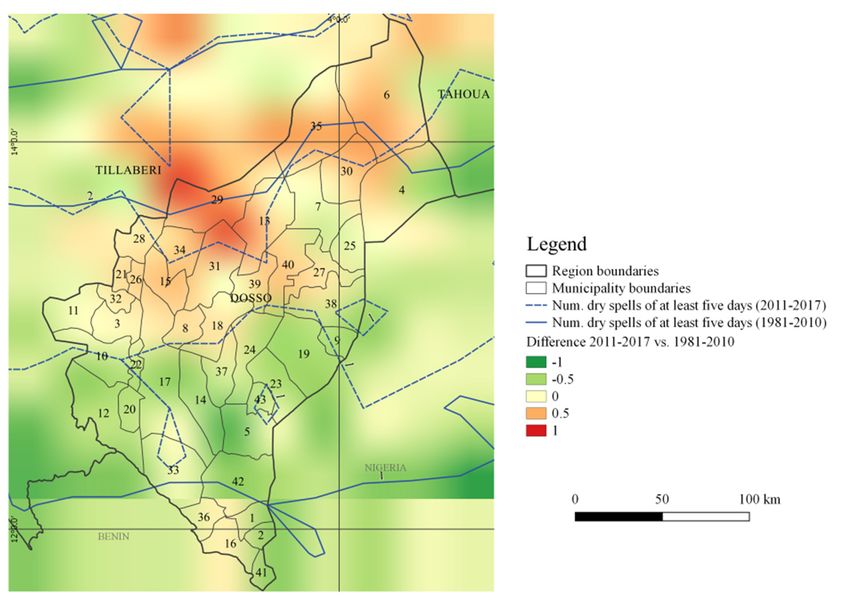
Climate 2018, 6, 67                                                                                   3 of 29

technique that should be used. The risk equation (R) chosen combines hazard (H), understood as the
“potential occurrence of a natural physical event that may cause loss of life, injury[,] or damage to
property” [58] and potential loss and damages (L&D): R = H * L&D. The decision to use this equation
instead of one that includes vulnerability and exposure [59,60] was dictated by the impossibility of
ascertaining accurately, for each municipality, the level of vulnerability and exposure. Digital elevation
models (DEM) with an absolute accuracy (the difference between a point on the model and the same
point on the ground) from 16–20 m (for SRTM and ASTER DEM) to 4 m (for 1:200,000 maps) and
the spatial resolution of barely 250–1000 m of the satellite images (MODIS) commonly used in risk
analysis in West Africa end up including settlements that are not prone to flooding. In view of these
considerations, this risk assessment uses L&D instead of vulnerability and exposure.
      The second step involves risk identification. This step also identifies the L&D datasets that should
be used in the assessment, which settlements have been hit by different hydroclimatic events and how
often over the past few years, the municipal development plans (MDPs), the adaptation and resilience
projects that are being applied in the region that will help exemplify the use of the assessment, as well
as the factors that turn floods and drought into disasters.
      The third step involves the analysis of risk. This starts by understanding which risk, determinant,
and indicator has a greater effect on the MHRI and then calculates the MHRI for each municipality in
the region, representing it on a map.
      The fourth step deals with the potential use of the assessment. This becomes clear when comparing
the map of the MHRI with the intervention areas of the 12 projects for climate adaptation and resilience
currently running in the region and with the adaptation actions envisaged by these projects and by
six MDPs.
      The most significant results of the assessment concern hazard characterization during the period
examined, the level of single and multihazard risk, the municipalities that are neglected by CC
adaptation and resilience projects, and the inconsistencies between categories of actions envisaged by
MDPs     and 6,prevailing
Climate 2018,   x FOR PEERthreats.
                           REVIEW                                                                    3 of 29

                         Figure
                         Figure 1.
                                1. The
                                   The 43
                                       43 municipalities
                                          municipalities of
                                                         of the
                                                            the Dosso
                                                                Dosso region, Niger.
                                                                      region, Niger.

      The assessment considers pluvial flooding, fluvial flooding, and meteorological drought because
other climatic hazards affecting Dosso (such as heat waves) are not systematically recorded at a
municipal level. The three risks are then combined in a multihazard risk index (MHRI) with respect
to the consistency of the period of time observed, the occurrence probability (1981–2017), the weight
of risk determinants, the range of risk classes, the minimal unit of analysis (municipality), and the
indicator measure (quantitative) [55].
      The assessment is divided into four steps [56] (Figure 2).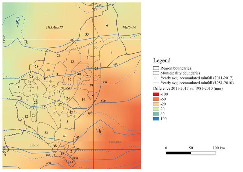
Climate 2018, 6, 67                                                                                        4 of 29
       Climate 2018, 6, x FOR PEER REVIEW                                                            4 of 29

                          Figure 2. A schematic overview of the multihazard risk assessment [56].
                      Figure 2. A schematic overview of the multihazard risk assessment [56].
            The third step involves the analysis of risk. This starts by understanding which risk,
2. Materials and Methods
     determinant, and indicator has a greater effect on the MHRI and then calculates the MHRI for each
       municipality in the region, representing it on a map.
2.1. Context
          The fourth step deals with the potential use of the assessment. This becomes clear when
     comparing the map of the MHRI with the intervention areas of the 12 projects for climate adaptation
2.1.1. Hazard Trends
     and resilience currently running in the region and with the adaptation actions envisaged by these
     projects
     The      and by
          context     six MDPs. precipitation and river height over a period of 37 years (1981–2017).
                   considered
The Climate Hazards groupresults
          The  most significant      of thePrecipitation
                                InfraRed     assessment concern  hazard characterization
                                                          with Stations                  duringestimates
                                                                          (CHIRPS) dataset      the perioddaily
     examined, the level of single and multihazard    risk, ◦the municipalities that are neglected by CC
rainfall on an almost global scale (50 S–50 N, 180 E–180 W), with a resolution of 0.25◦ [61].
                                           ◦       ◦                 ◦
     adaptation and resilience projects, and the inconsistencies between categories of actions envisaged
This allowed us to understand the recent (2011–2017) spatial distribution of annual rainfall and heavy
     by MDPs and prevailing threats.
rains (over 20 mm) compared to 1981–2010 climatology. Drought hazard is the probability of occurrence
of at least  two months
      2. Materials         during the farming season (June–September) of a Standardized Precipitation
                    and Methods
Index (SPI) that is equal to or less than −0.5 using the CHIRPS dataset for 2011–2017 with 1981–2010
      2.1. Contextperiod. The height of the River Niger was observed at the Malanville gauge (Benin),
as a reference
opposite the city of Gaya (Niger), using data from the ABN. These floods affect only five municipalities
      2.1.1. Hazard Trends
in the region and only the red ones are determined by local rainfalls conveyed into the river by the
Bosso dallolTheand
                context
                    the considered
                        right bankprecipitation
                                   tributaries, and
                                                suchriver height
                                                      as the     over
                                                             Sirba,   a period
                                                                    the        of 37
                                                                         Mekrou,     years
                                                                                   the     (1981–2017).
                                                                                       Alibou,  and theThe
                                                                                                        Sota.
       Climate Hazards group InfraRed Precipitation with Stations (CHIRPS) dataset estimates daily rainfall
2.1.2. on an Criteria
        Risk almost global scale (50° S–50° N, 180° E–180° W), with a resolution of 0.25° [61]. This allowed

     Risk analysis was carried out using an historical approach [62] (what has happened over the past
seven years) and the index technique. The MHRI was constructed using information regarding hazard
(H) and loss and damages (L&D): MHRI = H * L&D. This index is an alternative for all those cases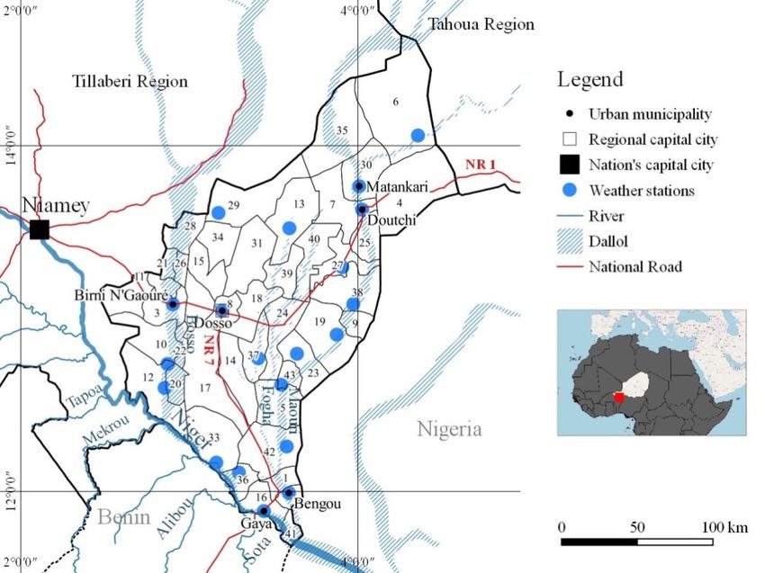
Climate 2018, 6, 67                                                                                5 of 29

in which the information available on vulnerability, exposure, and adaptive capacity is not precise
or irregular, but instead, there is reliable and regularly collected information on loss and damage.
It considers three risks to have a comparative view of the most frequent hydroclimatic threats in Niger
and to identify, among them, the most relevant one.
     The MHRI was divided up into five categories that are equally represented: severe (31.2–45.2),
high (17.2–31.1), elevated (3.1–17.1), low (0.01–3), and negligible (0).

2.2. Risk Identification

2.2.1. Dataset Identification
     The identification of L&D was done by comparing three global open-access datasets (Desinventar,
NatCatService, EM-DAT) and three national limited-access datasets (food security survey, flood L&D,
cereal deficit).

2.2.2. Exposed Settlements
     Settlements exposed to pluvial and fluvial flooding and drought were identified using the names
of the places listed in the two datasets chosen to appraise L&D following disasters that took place
during the 2011–2017 period. The names of the 1458 settlements extracted from the two datasets were
linked to those in the National Repository of Human Settlements [63], which lists the geographic
coordinates and the population of all Niger’s populated places. Once this was done, it proved possible
to produce exposure maps for each hazard. The municipal population was then used to compare the
severity of L&D with the demographic importance of the municipality within its region.

2.2.3. Plans and Projects
     The MDPs were made available by Dosso’s regional government. Each municipality has a plan.
The plans developed after 2011 are second-generation versions in that they contain a snapshot analysis
of the local climate and specific CC adaptation measures, as legally required by the Ministry of Spatial
Planning and Community Development. The projects were identified by carrying out an Internet
search using the keywords “risk reduction”, “adaptation”, “resilience”, “project”, and “program”
in English and French, followed by the names of the 18 main multi-bilateral donors operating in
Niger and checking the projects that emerged from this process against those known to Dosso’s
regional government.

2.2.4. The Factors that Cause Disasters
     A focus group in the Falmey, Guéchémé, Kiéché, Tessa, and Tougouna municipalities, considered
representative of the communities particularly hit by hydroclimatic disasters and at the same time
of each agroecological zone of the region, was set up in 2018. This provides an understanding of the
factors that turn hydroclimatic threats into disasters.

2.3. Risk Analysis
      The risk analysis highlights, first and foremost, the principal risk, determinant, and indicator.
It then goes on to calculate the MHRI as the sum of the pluvial flooding, fluvial flooding, and drought
risk indices and represents this on a map.
      The pluvial flood hazard used data from the DMN’s network of weather stations in order to
calculate more accurate rainfall figures. In this case, we identified the amount of daily precipitation
that could lead to flooding (critical rainfall) for each disaster recorded in the Dosso region. We sought
these figures in the days immediately preceding the disaster as recorded at the municipality’s weather
station or, in its absence, in that of adjacent municipalities located uphill from the municipality that
reported damage. The inverse of return period was calculated using the methodology proposed by
Gumbel [64] (Equations S1) considering the 1981–2017 period as a climatological reference.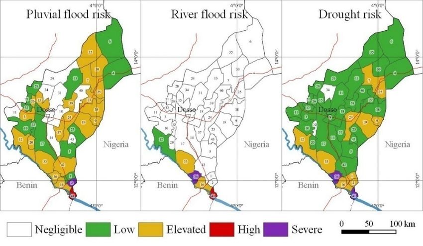
Climate 2018, 6, 67                                                                                6 of 29

     Drought hazard used the monthly SPI [65] for the months of the farming season in the region
(June–September) using the CHIRPS dataset. The SPI index characterizes the deviation from normal
rainfall; thus, the prolonged presence of negative figures identifies years when rain-fed crops could
have problems. CHIRPS images provided figures for monthly SPI for each grid point in the region
(Table S2). Each municipality could be associated with the grid point that fell within its bounds and
therefore characterized hazard on a municipal scale.
     River flood hazard was calculated from the height of the River Niger observed at the Malanville
gauge (Benin) on the date of each disastrous flood and then assessed the inverse of return period
within the 1981–2017 dataset of flood heights using the same procedure used for pluvial flooding.
     Flood L&D was measured using three indicators: the number of victims (L), the number of houses
destroyed, and the surface area of flooded fields (D). The information was recorded by the Ministry of
Humanitarian Action and Disaster Management (MAHGC) following 20 catastrophic floods that took
place in the Dosso region from 2011 to 2017.
     Drought L&D was measured by a proxy indicator using the “cereal deficit” annually estimated
by the Ministry of Agriculture and Livestock (MAE) for each settlement. For the purposes of this
assessment, the deficit of each municipality was quantified as the average proportion of people who
cannot be fed with locally produced cereals:

 Drought L&D year x = (P cannot be fed with the local production of year x × 100)/P settlement year 2012

     The total number of houses and the extent of fields in the Dosso region and its municipalities is
not known. As a result, the L&D for each municipality was linked to its population, and the resulting
figure was linked to the comparison between regional L&D and the region’s population:

Rmunicipality x = Hmunicipality x × (L&Dmunicipality x/Pmunicipality x)/(L&Dregion/Pregion)

where:
      H = probability of occurrence of a rainy day having caused L&D during the 2011–2017 period;
      L&D = loss and damages during the 2011–2017 period;
      P = population according to the 2012 national census [63].
      In other words, L&D is compared to the demographic weight of each municipality in the region.
The MHRI is obtained by summing up the individual risks calculated for each of the 43 municipalities
of the 2018,
Climate Dosso6, xregion (Figure
                  FOR PEER      3).
                           REVIEW                                                            7 of 29

                               Figure 3. Risk determinants and indicators.
                               Figure 3. Risk determinants and indicators.

2.4. The Potential Use of the Risk Index and Maps
2.4. The Potential Use of the Risk Index and Maps
      The potential applications of the multihazard risk assessment became clear when comparing the
      The potential applications of the multihazard risk assessment became clear when comparing the
principal risk, determinant, and indicator with the categories of actions, the budget, and the number
principal risk, determinant, and indicator with the categories of actions, the budget, and the number
of plans [66–71] and projects [72–83] that are underway in the region. Information regarding actions
was sourced from the intermediate and final evaluation reports of individual projects. The actions
were grouped according to the categories defined by Biagini et al. [84] to make the analysis of
consistency easier.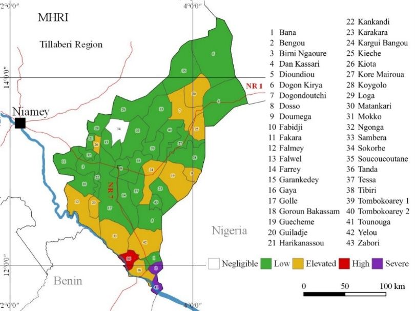
Climate 2018, 6, 67                                                                                            7 of 29

of plans [66–71] and projects [72–83] that are underway in the region. Information regarding actions
was sourced from the intermediate and final evaluation reports of individual projects. The actions
were grouped according to the categories defined by Biagini et al. [84] to make the analysis of
consistency easier.

2.5. Uncertainties
     The greatest uncertainties concerned basic information (the geographical density of weather
stations, the location and population of settlements that were hit by flooding and drought, and the
level of cereal deficit). Municipalities lacking a weather station with a dataset of at least 30 years
were attributed the rainfall measurement of the weather station closest to them and located uphill.
The settlements with an unspecified level of deficit were given the average deficit level of the
municipality to which they belong. The method remains valid despite such guesswork. For the
purposes of this assessment, it was enough to consider that the level of risk for the municipalities
lacking information might be underestimated or overestimated.

3. Results

3.1. Context

Hazard Trends
     During the 2011–2017 period, there was a reduction in rainfall of 20–40 mm/year throughout
the region compared to the 1981–2010 period (Figure 4). Nevertheless, in the municipalities of
BirniN’Gaoure, Dan Kassari, Dogon Kirya, Loga, Matankari, N’Gonga, and Soucoucoutane (3, 4, 6,
29, 30, 32, and 35 at Figure 5), despite the reduction in annual accumulated rainfall, the number of
extremely   heavy
 Climate 2018,        precipitation
               6, x FOR PEER REVIEW days (>20 mm) increased.                                   8 of 29

        Figure4. 4.The
      Figure        The  difference
                       difference    in average
                                  in average    accumulated
                                             accumulated      rainfall
                                                         rainfall      during
                                                                  during      2011–2017
                                                                         2011–2017       and 1981–2010
                                                                                    and 1981–2010        (rainfall
                                                                                                  (rainfall data
        datathe
      from   from    the Climate
                 Climate   HazardsHazards  group InfraRed
                                     group InfraRed        Precipitation
                                                    Precipitation        with Stations
                                                                  with Stations        (CHIRPS)
                                                                                (CHIRPS)         dataset).
                                                                                          dataset).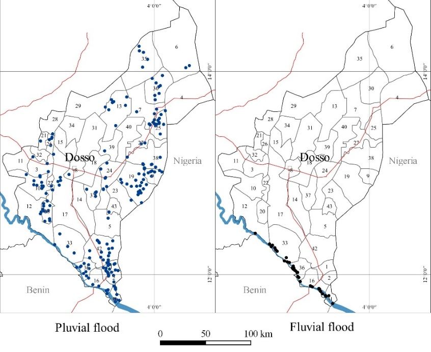
Figure 4. The difference in average accumulated rainfall during 2011–2017 and 1981–2010 (rainfall
Climate 2018, 6, 67                                                                                     8 of 29
            data from the Climate Hazards group InfraRed Precipitation with Stations (CHIRPS) dataset).

           Figure
      Figure 5. The5.difference
                      The difference
                                in theinaverage
                                          the average number
                                                 number       of rainy
                                                        of rainy       days over
                                                                 days with  with 20
                                                                                 over
                                                                                    mm20in
                                                                                         mmthein2011–2017
                                                                                                  the 2011–2017
                                                                                                           and and
           1981–2010   periods  (rainfall data from
      1981–2010 periods (rainfall data from CHIRPS).CHIRPS).

           The increase in the frequency of extremely heavy precipitation days increases the probability of
      The increase in the frequency of extremely heavy precipitation days increases the probability of
      creating conditions that can lead to pluvial flooding.
creating conditions that can lead to pluvial flooding.
           The distribution of the number of dry days and the number of spells with at least five dry days
      The distribution of the number of dry days and the number of spells with at least five dry days
      during the growing season differs from one part of the region to another, with figures that rise as
during the growing season differs from one part of the region to another, with figures that rise as high
      high as +2 days in the longest stretch of drought and +1 dry spell of at least five days during the
as +2 days in the longest stretch of drought and +1 dry spell of at least five days during the growing
      growing season (Figure 6).
season (Figure 6).
      The northern and western parts of the region particularly suffer from more extreme conditions of
drought. Over the past seven years, the municipalities of Birni N’Gaoure (3 at Figure 6), Dosso (8),
Fakara (11), Falmey (12), Garankedey (15), Golle (17), Gorou Bakassam (18), Harikanassou (21), Kiota
(26), Koygolo (28), Ngonga (32), Sokorbe (34), Soucoucoutane (35), and Tessa (37) have recorded many
prolonged droughts. The municipalities of Dogon Kiria, Falwel, Kore Mairoua, Loga, Matankari,
Mokko, Sakadamna, and Tombokoarey I only recorded a larger number of dry spells of at least 5 days
during the growing season. This unequal distribution of rainfall increases the risk that the harvest of
rain-fed crops will be lost.
      The River Niger’s annual cycle features two floods. One flood takes place during the wet season,
fed by local precipitation and known as a “red flood” due to the color of the sediment carried by the
water. The other flood takes place during the dry season and is called a “Guinean flood” because it
is caused by precipitation in the part of Guinea that this great river crosses. Red floods are usually
slightly higher than Guinean floods. Over the past six years, red floods have considerably exceeded
Guinean floods and have reached particularly high levels compared to the previous 31 years (Figure 7).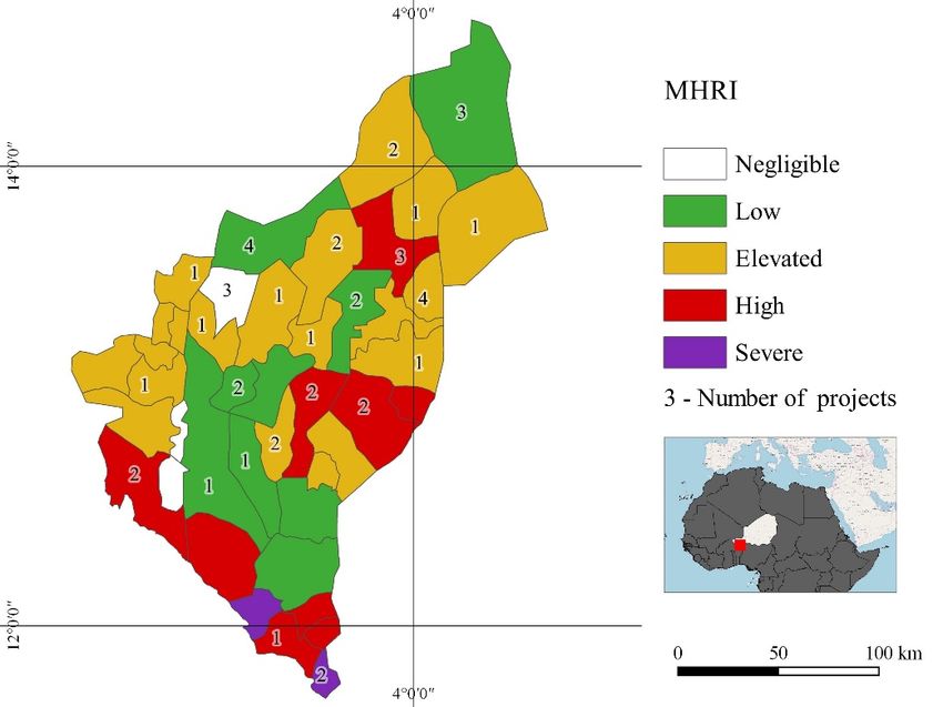
Climate 2018, 6, 67                                                                                      9 of 29
 Climate 2018, 6, x FOR PEER REVIEW                                                                      9 of 29

                                                       (a)

                                                       (b)
      Figure 6. The difference in the maximum number of consecutive dry days between 2011–2017 and
     Figure 6. The difference in the maximum number of consecutive dry days between 2011–2017 and
      1981–2010 (a); the difference in the number of spells of at least five dry days between 2011–2017 and
     1981–2010 (a); the difference in the number of spells of at least five dry days between 2011–2017 and
      1981–2010 (b) (rainfall data from CHIRPS).
     1981–2010 (b) (rainfall data from CHIRPS).

       The northern and western parts of the region particularly suffer from more extreme conditions
 of drought. Over the past seven years, the municipalities of Birni N’Gaoure (3 at Figure 6), Dosso (8),
 Fakara (11), Falmey (12), Garankedey (15), Golle (17), Gorou Bakassam (18), Harikanassou (21), Kiota
 (26), Koygolo (28), Ngonga (32), Sokorbe (34), Soucoucoutane (35), and Tessa (37) have recorded
 many prolonged droughts. The municipalities of Dogon Kiria, Falwel, Kore Mairoua, Loga,
 Matankari, Mokko, Sakadamna, and Tombokoarey I only recorded a larger number of dry spells of
 at least 5 days during the growing season. This unequal distribution of rainfall increases the risk that
 the harvest of rain-fed crops will be lost.
The River Niger’s annual cycle features two floods. One flood takes place during the wet season,
fed by local precipitation and known as a “red flood” due to the color of the sediment carried by the
water. The other flood takes place during the dry season and is called a “Guinean flood” because it
is caused by precipitation in the part of Guinea that this great river crosses. Red floods are usually
slightly
Climate higher
2018, 6, 67 than Guinean floods. Over the past six years, red floods have considerably exceeded
10 of 29
Guinean floods and have reached particularly high levels compared to the previous 31 years (Figure 7).
Figure 7. Peaks of the River Niger at Malanville (Benin) during local (red) and Guinean (white) floods,
Figure 7. Peaks of the River Niger at Malanville (Benin) during local (red) and Guinean (white)
1980–2017.
floods, 1980–2017.
3.2. Risk Identification
3.2. Risk Identification
3.2.1. Dataset
3.2.1. Dataset Identification
Identification
As far
As far as
as risk
risk identification
identification is is concerned,
concerned,six sixdatasets
datasetson onL&DL&Dwere werecompared.
compared.Desinventar,
Desinventar, a
aproduct
product of the project
of the sponsored
project sponsored by UNISDR
by UNISDR [85], is[85],
an open-access worldwide
is an open-access database database
worldwide on disasters. on
In the Dosso region, Desinventar covers the 1988–2013 period and,
disasters. In the Dosso region, Desinventar covers the 1988–2013 period and, therefore, only therefore, only part of the part
periodof
considered
the here (2011–2017),
period considered during which
here (2011–2017), eight
during floods
which andfloods
eight one drought
and onewere recorded.
drought EM-DAT
were recorded.
[30], produced
EM-DAT by Louvain
[30], produced CatholicCatholic
by Louvain University, recorded
University, 12 events
recorded on a national
12 events scalescale
on a national during the
during
2011–2017 period. NatCatService [86], produced by Munich RE, recorded
the 2011–2017 period. NatCatService [86], produced by Munich RE, recorded five hydroclimatic events five hydroclimatic events
in Niger
in Niger from
from 2011
2011 to to 2017.
2017.The TheJoint
JointSurvey
Survey ononVulnerability
Vulnerability to to
Food
FoodInsecurity
Insecurity [87], compiled
[87], compiled by
the the
by Coordination
Coordination Unit Unit of ofthetheEarly
EarlyWarning
WarningSystemSystem (CC/SAP)
(CC/SAP)on on aa national scale, contains
national scale, contains
information on the victims and causes of flooding. In the Dosso region,
information on the victims and causes of flooding. In the Dosso region, the survey is conducted the survey is conducted
through interviews
through interviews with with households.
households. It It does
does not
not produce
produce electronic
electronic data on aa municipal
data on municipal scalescale and
and
does not cover the region’s seven urban areas. The Flood dataset [88,89]
does not cover the region’s seven urban areas. The Flood dataset [88,89] was compiled from 1998 to was compiled from 1998 to
2011 by the CC/SAP on a national scale in conjunction with the National
2011 by the CC/SAP on a national scale in conjunction with the National Device for the Prevention Device for the Prevention
and Management
and Management of of Food
Food Crises,
Crises, which
which operates
operates on on the
the ground
ground with
with the
the Community
Community Early Early Warning
Warning
System and Emergency Response (SCAP-RU) and the Observatories
System and Emergency Response (SCAP-RU) and the Observatories for Vulnerability Monitoring for Vulnerability Monitoring
(OSV). From
(OSV). From 20122012 to to 2015,
2015, this
this task
task was
was handed
handed over
over toto the
the Humanitarian
Humanitarian Coordination
Coordination Unit Unit and
and
subsequently to
subsequently to the
the MAHGC.
MAHGC. The The dataset
dataset records
records flooded
flooded settlements,
settlements, their
their geographic
geographic coordinates,
coordinates,
the date flooding took place (20 events from 2011 to 2017),
the date flooding took place (20 events from 2011 to 2017), the duration of the the duration of the event,
event, and
and thethe loss
loss
(victims) and
(victims) and damage
damage (houses,
(houses, fields,
fields, livestock,
livestock, infrastructure).
infrastructure). The The List
List of Deficit Settlements
of Deficit Settlements is is
drafted every year by the MAE [90] and estimates crop yields in sample
drafted every year by the MAE [90] and estimates crop yields in sample villages chosen at random. villages chosen at random.
Deficit is
Deficit is worked
worked out out byby comparing
comparing estimated
estimated production
production with with the
the requirement
requirement of of local
local inhabitants
inhabitants
using aa standard
using standard per per capita
capita consumption
consumption figure of 231
figure of 231 kg
kg of
of cereal
cereal per
per year.
year. The
The list
list states
states the
the level
level
of deficit caused by drought (a late start and an early end to the growing
of deficit caused by drought (a late start and an early end to the growing season, dry spells) per season, dry spells) per
settlement. From 2011 to 2017, drought took place every year. For
settlement. From 2011 to 2017, drought took place every year. For assessment purposes, we chose assessment purposes, we chose
MAHGC and
MAHGC and MAE
MAE datasets
datasets duedue to to their
their greater detail, more
greater detail, more up-to-date
up-to-date information,
information, and and the
the fact
fact that
that
they are updated on an annual
they are updated on an annual basis. basis.
3.2.2. Exposed Settlements
Pluvial flooding hits 6% of the region’s settlements (24 settlements are repeatedly flooded) and
17% of the population. By population, here, we mean the entire population of the affected settlements,
not the population actually damaged. This is because, especially in the smaller settlements, it is theClimate 2018, 6, x FOR PEER REVIEW 11 of 29
3.2.2. Exposed Settlements
ClimatePluvial flooding
2018, 6, 67 hits 6% of the region’s settlements (24 settlements are repeatedly flooded) and
11 of 29
17% of the population. By population, here, we mean the entire population of the affected settlements,
not the population actually damaged. This is because, especially in the smaller settlements, it is the
entire
entire population
population that
that is
is involved
involved inin mutual
mutual aid
aid after
after the
the disaster
disaster and
and suffers
suffers from
from the
the inconvenience
inconvenience
caused by the temporary interruption of infrastructure operation. Almost
caused by the temporary interruption of infrastructure operation. Almost all of these all of these settlements
settlements are
are located in the dallols (old river beds with a shallow water table) that are prone to
located in the dallols (old river beds with a shallow water table) that are prone to runoff when extremerunoff when
extreme rainsWhen
rains occur. occur.the
When theNiger
River River bursts
Niger bursts its banks,
its banks, it affects
it affects 1% of1%the
of region’s
the region’s settlements
settlements (36
(36
settlements, of which 15 are repeatedly flooded) and 2% of the region’s population (Figure 8). 8).
settlements, of which 15 are repeatedly flooded) and 2% of the region’s population (Figure
Figure 8.
Figure 8. Settlements of the Dosso region affected more than one year (dots) by pluvial flooding (left)
and
and fluvial
fluvial flooding
flooding (right)
(right) from
from2011
2011to
to2017.
2017.
Drought affects
Drought affects 24%
24% of of settlements
settlements andand 48%
48% ofof the
the population
population (548
(548 settlements
settlements are
are hit
hit twice
twice or
or
more, particularly
more, particularly in
in the
the central
central part
part of
of the
the region)
region)(Figure
(Figure9).
9).
It is more common for the same settlements to be
It is more common for the same settlements to be repeatedly affected repeatedly affected byby drought
drought (48%(48% of
of
settlements) and fluvial flooding (42% of settlements) as opposed to pluvial flooding
settlements) and fluvial flooding (42% of settlements) as opposed to pluvial flooding (only 8%). (only 8%). Two
percent
Two of settlements
percent are hit
of settlements arebyhitdrought
by droughtand and
pluvial floods
pluvial in 31
floods in municipalities,
31 municipalities,particularly the
particularly
Guéchémé, Bana, and Fabidji municipalities (19, 1, and 10 at Figure 8, Tables
the Guéchémé, Bana, and Fabidji municipalities (19, 1, and 10 at Figure 8, Table 2 and Table S3). 2 and S3). Thirty-eight
settlements are
Thirty-eight hit by pluvial
settlements are hitfloods and drought
by pluvial floods andin the same year.
drought in theAll urban
same settlements
year. All urbanare affected.
settlements
Twenty-nine percent of settlements located in a buffer zone of 500 m from
are affected. Twenty-nine percent of settlements located in a buffer zone of 500 m from the banksthe banks of the River
of
Niger and 20% of those found in the dallols have been flooded over the past seven
the River Niger and 20% of those found in the dallols have been flooded over the past seven years. years.Climate 2018, 6, 67 12 of 29
Climate 2018, 6, x FOR PEER REVIEW 12 of 29
Figure 9. Settlements of the Dosso region affected more than one year (dots) by drought from 2011 to
Figure 9. Settlements of the Dosso region affected more than one year (dots) by drought from 2011
2017.
to 2017.
Table 2. Human settlements in the Dosso region flooded and affected by agricultural drought from
2. Human
Table2011 to 2017. settlements in the Dosso region flooded and affected by agricultural drought from
2011 to 2017.
Settlements Pluvial Flood Fluvial Flood Drought Multihazard
Number 277 36 1135 121
Settlements Pluvial Flood Fluvial Flood Drought Multihazard
% of regional settlements 6 1 24 2
Number
Population number 277 345,859 36 32,167 1135
987,842 121
235,826
% of regional
% of regional population 6 17 1 2 2448 12 2
settlements
Population number 345,859 32,167 987,842 235,826
3.2.3. Plans and Projects
% of regional
17 2 48 12
population
Six MDPs, representing municipalities at severe, high, and elevated risk, and the 12 adaptation
and resilience projects currently underway or recently completed in the region of Dosso by the state
3.2.3.and international
Plans and Projectsaid organizations were identified. The categories of actions, their budgets, and the
municipalities benefiting from these projects were compared to the risk, the determinant, and the key
Six MDPs,
indicator as representing municipalities
well as to the MHRI in order toat severe, high,
demonstrate the and elevated
potential use ofrisk, andassessment.
the risk the 12 adaptation
and resilience projects currently underway or recently completed in the region of Dosso by the state
3.2.4. Factors that
and international aid Contribute
organizationsto Causing Disasters The categories of actions, their budgets, and the
were identified.
municipalities
Thanksbenefiting from these
to focus groups projects
organized were
in five compared
settlements to the to
selected risk, the determinant,
represent and the key
each agroecological
indicator
zone as well
of the as to the
region, thefactors
MHRIthatin order to demonstrate
turn flooding theinto
and drought potential
a disasteruse of the
were risk assessment.
ascertained (Table 3).
In the case of pluvial flooding, a critical factor is the absence of protection for receptors, while in
3.2.4.the
Factors
case ofthat Contribute
fluvial flooding, to
it isCausing Disasters
the absence of an early warning system. In the case of drought, critical
factors include the lack of a rain gauge, which would allow farmers to choose to sow rain-fed crops
Thanks to focus groups organized in five settlements selected to represent each agroecological
when enough rain has fallen, the use of drought-resistant cultivars that ripen before the rainy season
zone of the region, the factors that turn flooding and drought into a disaster were ascertained (Table 3).
comes to an early end, and insufficient soil and water conservation that help in managing soil
In the case of pluvial flooding, a critical factor is the absence of protection for receptors, while in
moisture.
the case of fluvial flooding, it is the absence of an early warning system. In the case of drought, critical
factors include the lack of a rain gauge, which would allow farmers to choose to sow rain-fed crops
when enough rain has fallen, the use of drought-resistant cultivars that ripen before the rainy season
comes to an early end, and insufficient soil and water conservation that help in managing soil moisture.Climate 2018, 6, 67 13 of 29
Table 3. Factors contributing to disastrous floods and drought as ascertained in Falmey, Guéchemé,
Kiéché, Tessa, and Tounouga municipalities in July 2018.
Climate 2018, 6, x FOR PEER REVIEW 13 of 29
Hazard Impact Disaster Factors
Table 3. Factors contributing to disastrous floods and drought as ascertained in Falmey, Guéchemé,
Lack of elevated threshold at house
Pluvial
Kiéché,flood Houses
Tessa, and Tounouga collapse
municipalities in July 2018. entrance
Hazard Impact Lack of corrugated ironFactors
Disaster roof
Pluvial flood Houses collapse Lack
Lackof
ofelevated
plaster threshold at house entrance
Reduced access to water Lack
Unraised basement iron
of corrugated roofand fountains
of wells
Lack of plaster
Environmental pollution Unraised latrines
Reduced access to water Unraised basement of wells and fountains
Fluvial flood Loss of livestock, agricultural tools Lack of early warning
Environmental pollution Unraised latrines
Fluvial and
Fluvial flood pluvial flood Houses collapseagricultural tools Lack
Loss of livestock, Lackof
ofearly
unraised basement
warning
Fluvial and pluvial flood Houses collapse Lack
Lackofofunraised basement
rain gauge
Drought Crop loss Lackof
Lack ofrain
drought-resistant
gauge cultivars
Drought Crop loss Lack of water and soil conservation
Lack of drought-resistant cultivars
Lack of water and soil conservation
3.3. Risk Analysis
3.3. Risk Analysis
The Principal Risk, Determinant, and Indicator
The Principal Risk, Determinant, and Indicator
One of the first aspects that should be taken into account when analyzing multihazard risk
is which One of the
risk, first aspects
determinant (Hthat shouldand,
or L&D), be taken into
of the account
latter, when
which analyzing
indicator multihazard
(victims, houses, risk is
fields,
which
crop risk,counts
failure) determinant (H or L&D),
more when and, ofthe
determining the MHRI.
latter, which indicatorallows
This analysis (victims, houses,
us to verifyfields,
whethercropthe
failure)
actions counts more
developed whenand
by plans determining the MHRI.
projects address Thisdeterminant,
the risk, analysis allowsanduskey to indicator.
verify whether the
actions developed by plans and projects address the risk, determinant, and key indicator.
The risk of pluvial flooding influences the MHRI the most (Figure 10a). The recurrence period of
pluvialThe risk ofvaries
flooding pluvial flooding
from influences
0.08 to the MHRI figure
1. The maximum the most (Figure a10a).
indicates The recurrence
disastrous period
event that could
of pluvial flooding varies from 0.08 to 1. The maximum figure indicates a disastrous event that could
reoccur on an annual basis, as in Dosso, Falmey, and Gourou Bankassam. In 10 municipalities, there
reoccur on an annual basis, as in Dosso, Falmey, and Gourou Bankassam. In 10 municipalities, there
were no critical events in the period from 1981 to 2017. The recurrence period of fluvial flooding
were no critical events in the period from 1981 to 2017. The recurrence period of fluvial flooding
varies from 0.3 to 0.6 (Tounouga), while meteorological drought varies from 0.5 (8 municipalities)
varies from 0.3 to 0.6 (Tounouga), while meteorological drought varies from 0.5 (8 municipalities) to
to 0.83 (14 municipalities). L&D due to pluvial flooding is higher in the municipalities of Bengou,
0.83 (14 municipalities). L&D due to pluvial flooding is higher in the municipalities of Bengou, Bana,
Bana, and Tounouga, while L&D due to fluvial flooding is higher in Tanda, Tounouga, and Gaya,
and Tounouga, while L&D due to fluvial flooding is higher in Tanda, Tounouga, and Gaya, and
and vulnerability
vulnerability to drought
to drought is higher
is higher in Doumega
in Doumega and and
Bana.Bana. The level
The level of riskofisrisk is determined
determined by L&D byand
L&D
and hardly ever by its hazard (Figure
hardly ever by its hazard (Figure 10b). 10b).
TheThe decisive
decisiveindicator
indicatorisisflooded
flooded fields,
fields, which
which in in the
the case
caseof
offluvial
fluvialflooding
floodingare areparticularly
particularly
widespread
widespread (Figure
(Figure 10).
10).
(a)
Figure 10. Cont.Climate 2018, 6, 67 14 of 29
Climate 2018, 6, x FOR PEER REVIEW 14 of 29
(b)
Figure
Figure 10.10.
TheThe importance
importance of of
thethe single
single components
components ofof risk
risk inin
thethe Dosso
Dosso region
region according
according toto threat,
threat,
2011–2017 (a) and the range of indicators of pluvial flooding, fluvial flooding, and drought risk (b)(b)
2011–2017 (a) and the range of indicators of pluvial flooding, fluvial flooding, and drought risk
using
using data
data from
from Table
Table 4. 4.
Table
Table 4. 4. Multihazardrisk
Multihazard risklevel
levelatatthe
themunicipal
municipal scale
scale in
in the
the Dosso
Dosso region,
region, 2011–2017
2011–2017(H-Hazard,
(H-Hazard,D-
Loss &
D-Loss & Damage,
Damage, R-Risk).
R-Risk).
Pluvialflood Fluvialflood Drought Multihazard
MunicipalityPluvialflood Fluvialflood Drought Multihazard
Municipality H D R H D R H D R R
1 Bana H D R
0.1 22.8 0.91 H D R H D
0.8 2.4 2.0 R 2.9 R
1 Bana 2 Bengou 0.1 22.81 0.91
45.2 45.17 0.8
0.8 02.4 0 2.0 45.2 2.9
2 Bengou3 Birni N’Gaoure 1 45.21 45.17
1.4 1.41 0.8
0.8 0.40 0.3 0 1.7 45.2
3 Birni N’Gaoure 1 1.4 1.41 0.8 0.4 0.3 1.7
4 Dan Kassari 1
4 Dan Kassari 0.6
1 0.64
0.6 0.64 0.8 1.1
0.8 1.1
0.9 0.9 1.6 1.6
5
5 Dioudiou Dioudiou 1 1.0 1 1.0 0.97
0.97 0.5 0.2
0.5 0.2 0.1 0.1 1.1 1.1
6 Dogon 6Kiria
Dogon Kiria0.99 00.99 0.03
0 0.03 0.7 0.8
0.7 0.8 0.5 0.5 0.6 0.6
7 Dogondoutchi
7 Dogondoutchi 1 3.4 1 3.37
3.4 3.37 0.5 0.7
0.5 0.7 0.4 0.4 3.8 3.8
8 Dosso 1 0 0 0.7 0.2 0.1
8 Dosso 1 0 0 0.7 0.2 0.1 0.1 0.1
9 Doumega 1 4.1 4.05 0.5 9.2 4.6 8.6
10 Fabidji9 Doumega 0.1 4.8 1 0.48
4.1 4.05 0.5 9.2
0.7 1.9 4.6 1.3 8.6 1.7
11 Fakara10 Fabidji 0.02 00.1 4.80 0.48 0.7 1.9
0.8 1.7 1.3 1.4 1.7 1.4
12 Falmey11 Fakara 1 2.1
0.02 2.14
0 0.3
0 2.7 0.9 0.8 0.3 1.4 0.2
0.8 1.7 1.4 3.3
13 Falwel12 Falmey 1 0.8 1 0.78
2.1 2.14 0.3 2.7 0.9 0.7 1.6
0.8 0.3 0.2 1.0 3.3 1.8
14 Farrey 1 0 0 0.7 0.5 0.3 0.3
13
15 Garankedey
Falwel 0.93 1.1
1 0.8 0.78
1.04
0.7 1.6
0.7 1.7
1.0 1.1 1.8 2.2
16 Gaya 14 Farrey 1 3.0 1 3.030 0
0.3 18.4 6.1 0.7 0.5
0.8 0.1 0.3 0.1 0.3 9.2
17 Golle 15 Garankedey1 0.93 0.14
0.1 1.1 1.04 0.7 1.7
0.7 0.4 1.1 0.2 2.2 0.4
18 GoroubanKassam
16 Gaya 1 0 1 0
3.0 3.03 0.3 18.4 6.1 0.7 0.9 0.1 0.6
0.8 0.1 9.2 0.6
19 Guéchémé 1 5.1 5.07 0.5 1.3 0.6 5.7
17 Golle 1 0.1 0.14 0.7 0.4 0.2 0.4
20 Guilladjé 1 9.0 8.98 0.7 0.4 0.3 9.3
18 GoroubanKassam
21 Harikanassou 1 0 1 0
0.02 0 0.7 0.9
0.8 1.9 0.6 1.5 0.6 1.6
19 Guéchémé 0.33
22 Kankandi 1.2 1 0.41
5.1 5.07 0.5 1.3
0.0 0.3 0.6 0 5.7 0.4
23 KaraKara
20 Guilladjé 1 0.8 1 0.83
9.0 8.98 0.7 1.7
0.7 0.4 0.3 1.2 9.3 2.0
24 KarguiBangou
21 Harikanassou 1 6.8 1 6.840 0.02 0.7 0.9
0.8 1.9 1.5 0.6 1.6 7.5
25 Kieché 1 2.8 2.8 0.8 0.7 0.5 3.4
26 Kiota 22 Kankandi 1 0.33
1.6 1,59 0.41
1.2 0.0 0.3
0.8 1.7 0 1.4 0.4 3.0
23 KaraKara 1
27 Kore Mairoua 1.4 1 1.43
0.8 0.83 0.7 1.7
0.7 1.6 1.2 1.0 2.0 2.2
24 KarguiBangou
28 Koygolo 1 0.5 1 0.48
6.8 6.84 0.7 0.9
0.5 1.0 0.6 0.5 7.5 2.5
25 Kieché 1 2.8 2.8 0.8 0.7 0.5 3.4
26 Kiota 1 1.6 1,59 0.8 1.7 1.4 3.0
27 Kore Mairoua 1 1.4 1.43 0.7 1.6 1.0 2.2
28 Koygolo 1 0.5 0.48 0.5 1.0 0.5 2.5
29 Loga 1 0 0 0.5 1.0 0.5 0.5
30 Matankari 1 3.0 2.98 0.5 0.8 0.4 3.4Climate 2018, 6, 67 15 of 29
Table 4. Cont.
Climate 2018, Pluvialflood
6, x FOR PEER REVIEW Fluvialflood Drought Multihazard
15 of 29
Municipality
H D R H D R H D R R
29 Loga31 Mokko 1 10 00 0 0.80.5 1.4 1.01.2 0.5 1.2 0.5
32 N’Gonga
30 Matankari 1 0.9
3.0 1.02.98 0.92 0.80.5 0.4 0.80.3 0.4 1.2 3.4
31 Mokko
33 Sambera 1 10 1.60 1.55 0.5 7.8 3.8 0.50.8 0.10 1.40.1 1.2 5.4 1.2
32 N’Gonga 0.9 1.0
34 Sokorbé 1 00.92 0 0.70.8 0 0.40 0.3
0 1.2
33 Sambera 1 1.6 1.55 0.5 7.8 3.8 0.5 0.10 0.1 5.4
35 Soucoucoutane1
34 Sokorbé 10 1.30 1.33 0.70.7 0.9 00.6 0 2.0 0
36 Tanda
35 Soucoucoutane 1 1
1.3 5.0
1.33 4.97 0.3 69.3 22.9 0.70.7 0.2 0.90.1 0.6 28.0 2.0
36 Tanda
37 Tessa 1 5.0
1 4.97 1.960.3
2.0 69.3 22.9 0.70.7 1.1 0.20.8 0.1 2.7 28.0
37 Tessa
38 Tibiri 1 2.0
1 1.96
1.0 1.01 0.70.7 0.7 1.10.5 0.8 1.5 2.7
38 Tibiri 1 1.0 1.01 0.7 0.7 0.5 1.5
39 TomboKoarey
39 TomboKoarey I 1
I 1
1.0
1.0
1.03
1.03 0.70.7 1.5 1.51.0 1.0
2.1 2.1
40 TK 40 TK II-Sakadamna
II-Sakadamna 0.1 0.1
0 00 0 0.70.7 0.7 0.70.5 0.5 0.5 0.5
41 Tounouga
41 Tounouga 1 1 21.5
21.5 21.5121.510.7 0.7 20.4
20.4 13.7
13.7 0.80.8 0.5 0.50.5 0.5 35.6 35.6
42 Yelou
42 Yelou 1 4.4
1 4.36 4.36
4.4 0.80.8 0.5 0.50.5 0.5 4.8 4.8
43 Zabori 1 0 0 0.7 1.3 0.9 0.9
43 Zabori 1 0 0 0.7 1.3 0.9 0.9
3.4. From
3.4. From Single
Single to
to Multihazard
Multihazard Risk
Risk Levels
Levels
Risk (R)
Risk (R) is
is worked
worked out out by
by summing
summing the the probability
probability of of occurrence
occurrence of of aa hydroclimatic
hydroclimatic event
event (H)
(H)
and the L&D caused from 2011 to 2017:
and the L&D caused from 2011 to 2017: R = H * L&D. R = H * L&D.
When ititcomes
When comes to individual
to individualhazards (pluvial(pluvial
hazards flooding,flooding,
fluvial flooding,
fluvialdrought),
flooding,thedrought),
municipalities
the
with a risk level
municipalities withhigher
a riskthan
level1higher
demonstrate a risk that isa higher
than 1 demonstrate than
risk that their demographic
is higher weight in
than their demographic
the region.
weight Pluvial
in the region.risk affectsrisk
Pluvial 37 municipalities: severe in Bengou
affects 37 municipalities: severe in(2 Bengou
at Figure(210), high in10),
at Figure Tounouga
high in
Tounouga (41 at Figure 10), and elevated in municipalities crossed by the dallols, particularly(20),
(41 at Figure 10), and elevated in municipalities crossed by the dallols, particularly in Guilladje in
KarguiBangou
Guilladje (29), and Guechémé
(20), KarguiBangou (19).Guechémé
(29), and Fluvial flood
(19).risk affects
Fluvial five risk
flood municipalities
affects fiveand is severe in
municipalities
Tanda
and is (36) andinhigh
severe Tandain Tounouga
(36) and high(41). in
Drought
Tounouga risk is present
(41). Droughtin 41risk
municipalities
is present in but41with a low level
municipalities
andwith
but reaches a peak
a low levelinand
Doumega
reaches(9aatpeak
Figure 11).
in Doumega (9 at Figure 11).
Figure
Figure 11.
11. Pluvial
Pluvial flood
flood (left),
(left), fluvial
fluvial flood
flood (center),
(center), and
and drought
drought (right)
(right) risk
risk levels
levels from
from 2011
2011 to
to 2017
2017
in the Dosso region using data from Table
in the Dosso region using data from Table 4. 4.
The MHRI is obtained by summing the pluvial flood, fluvial flood, and drought risk indices. In
The MHRI is obtained by summing the pluvial flood, fluvial flood, and drought risk indices.
this case, a risk level higher than 3 indicates that the municipality concerned has a risk that is higher
In this case, a risk level higher than 3 indicates that the municipality concerned has a risk that is
than its demographic weight in the region. The level of risk is severe in the municipalities of Bengou
higher than its demographic weight in the region. The level of risk is severe in the municipalities of
(dallol) and Tounouga (River Niger), high at Tanda (River Niger), and elevated in another 12
Bengou (dallol) and Tounouga (River Niger), high at Tanda (River Niger), and elevated in another
municipalities, particularly in the dallols (Guilladje, Doumega, KarguiBangou) and along the river
(Gaya). The risk is low in 27 municipalities and negligible or absent in one of them (Figure 12, Table 4).Climate 2018, 6, 67 16 of 29
12 municipalities, particularly in the dallols (Guilladje, Doumega, KarguiBangou) and along the river
(Gaya). The risk is low in 27 municipalities and negligible or absent in one of them (Figure 12, Table
Climate 2018, 6, x FOR PEER REVIEW
4).
16 of 29
Figure 12. Multihazard risk at the municipal scale in the Dosso region, 2011–2017 using data from
Figure 12. Multihazard risk at the municipal scale in the Dosso region, 2011–2017 using data from
Table 4.
Table 4.
3.5. The Potential Use of Risk Assessment: Planning with Climate
3.5. The Potential Use of Risk Assessment: Planning with Climate
The potential use of risk assessment becomes clear when comparing the principal risk,
The potential use of risk assessment becomes clear when comparing the principal risk,
determinant, and indicator and the MHRI to the actions developed by plans and projects, their budget
determinant, and indicator and the MHRI to the actions developed by plans and projects, their
for action implementation, and the number of municipalities where they are implemented.
budget for action implementation, and the number of municipalities where they are implemented.
3.5.1. The
3.5.1. The Consistency
Consistency between
between Actions
Actions and
and the
the Principal
Principal Risk,
Risk, Determinant,
Determinant, and and Indicator
Indicator
Fluvial flooding,
Fluvial flooding, L&D,
L&D, and
and flooded
flooded fields
fields are
are the
the risk,
risk, the
the determinant,
determinant, and and the
the indicator,
indicator,
respectively, that influence the MHRI the most. Unfortunately, neither the MDPs
respectively, that influence the MHRI the most. Unfortunately, neither the MDPs nor the adaptation nor the adaptation
andresilience
and resilience projects
projects envisage
envisage antiflooding
antiflooding actionsactions
aimed at aimed at L&D
reducing reducing
or theL&D
use ofor the use of
embankments
embankments to protect fields
to protect fields from flooding. from flooding.
In Tounouga,
In Tounouga, whichwhich has
has been
been hit
hit several
several times
times byby fluvial
fluvial and
and pluvial
pluvial flooding,
flooding, actions
actions focus
focus on
on
reducingthe
reducing theimpact
impactofof drought.
drought. In Tanda,
In Tanda, which
which has been
has been hit several
hit several times
times by by flooding,
fluvial fluvial flooding,
actions
actions focus on reducing runoff and drought. In contrast, in Doumega,
focus on reducing runoff and drought. In contrast, in Doumega, hit by drought and pluvialhit by drought and pluvial
flooding,
flooding,
actions areactions are well and
well planned planned
focusandon focus
wateron water
and soiland soil conservation
conservation (WSC) and(WSC) and gardens.
gardens. The
The same
same is true for Dogondoutchi, Falmey, and Guéchémé, hit by pluvial flooding, where the main
is true for Dogondoutchi, Falmey, and Guéchémé, hit by pluvial flooding, where the main actions
actions consist in reducing runoff, planting trees, reinforcing the banks of creeks, and improving
consist in reducing runoff, planting trees, reinforcing the banks of creeks, and improving storm water
storm water drainage. Nevertheless, not one single municipality has planned either awareness
drainage. Nevertheless, not one single municipality has planned either awareness campaigns or the
campaigns or the monitoring of rainfall at a local level.
monitoring of rainfall at a local level.
3.5.2. The
3.5.2. The Consistency
Consistency between
between the
the Budget
Budget for
for Actions
Actions and
and the
the MHRI
MHRI Level
Level
Many large-scale
Many large-scale actions
actions should
should bebe put
put in
in place
place ifif we
we hope
hope to
to reduce
reduce risk.
risk. Unfortunately,
Unfortunately, the
the
quotaof
quota of the
the total
total budget
budget of of the
the six
six MDPs
MDPs set
set aside
aside for
for CC
CC adaptation
adaptation actions
actions is
is inversely
inversely proportional
proportional
to the MHRI level: very low in municipalities at severe risk (0.5–1.3%) and high in
to the MHRI level: very low in municipalities at severe risk (0.5–1.3%) and high in those considered those considered
to
to be at elevated risk (8.4–22.6%)
be at elevated risk (8.4–22.6%) (Table 5). (Table 5).Climate 2018, 6, 67 17 of 29
Table 5. The budget for pro-climate actions scheduled by six MDPs (figures expressed in thousands
of USD).
Municipality
Tounouga Tanda Douméga Guéchémé Dogondoutchi Falmey
Hazard * PF PF DF F F F
MHRI 36 28 9 6 4 3
Actions:
Training 1
OSV-SCAPRU 29 1
WSC 58 550 545 507
Treeplanting 75 81 8 4
Stoves 18
Culverts 64
Creeks 190
Drainage 28
Weir 319
Latrines 49
Seeds 4
Gardens 86 120 214 23
Imputbank 11 28 26 8
Cerealbank 11 47 73 19
* D-drought, F-Fluvial flood, P-Pluvial flood.
3.5.3. The Consistency between the Number of Projects and the MHRI Level
A third potential use of the MHRI involves verifying how consistent the number of projects and
the MHRI level are in each municipality. Twenty-three municipalities benefit from risk reduction,
adaptation, and resilience actions put in place by 12 projects. The appraisal, midterm, and final
evaluation reports of risk reduction, adaptation, and resilience projects allow us to identify which
municipalities boast actions that have been completed or are envisaged for the future and to compare
their distribution with the multihazard risk index (Table 6). If we group municipal projects according
to their risk classes, we notice that their geographical distribution does not reflect the MHRI level: we
find 1 project per municipality considered to be at severe risk, no projects in municipalities at high risk,
0.9 projects per municipality at elevated risk, 0.8 for those at low risk, and 3 projects in municipalities
at negligible risk (Figure 13, Table 6).You can also read