NWS Wilmington, Ohio February 2019 Regional Climate Summary Regional Climate Summary
←
→
Page content transcription
If your browser does not render page correctly, please read the page content below

NWS Wilmington, Ohio
               February 2019
         Regional Climate Summary

         Regional Climate Summary

   The month of February once again featured ample rainfall and
extended periods of above normal temperatures across the region.
    The weather pattern served several heavy rain events, which
  caused multiple episodes of both areal and river flooding across
parts of the area. Despite the lack of extended cold air, there were
several events which provided accumulating snow, particularly for
 northern segments of the region. However, the month will largely
          be remembered for how wet and warm it was.

                                1
Temperatures
            Although the month of January ended on quite a cold note, it didn’t
last long once the calendar flipped to February. In fact, much above normal
temperatures filtered into the Ohio Valley for most of the first week of the
month, with numerous days with highs in the 50s and even 60s. A cold front
ushered in a brief spell of chillier more seasonable air for several days before
temperatures again soared above normal for another extended stretch
through the middle of the month.
            Past the middle of the month, there were several days with near
normal temperatures before another unseasonably warm weather pattern
evolved from the 21st through the 24th. Temperatures quickly fell during the
day on the 24th as a strong cold front moved through, with very windy
conditions during the day. Even with this being said, temperatures dipped back
to near normal for just a couple of days, with the month ending on a bit of a
colder note as a light wintry mix moved through the region.
            Despite the generally warmer-than-normal temperatures
throughout the month, only a few daily records were reached or broken. At
Dayton, the low temperature only fell to 40˚F on the 6th, tying the record for
the date originally set in 1938. At Columbus, the high of 62˚F on the 7th and the
low of 43˚F broke the old daily records of 61˚F last set in 1925 and 42˚F set in
1991, respectively.

                                                   Departure From Maximum         Minimum
             Avg Temp   Avg High    Avg Low Temp
   Site                                               Normal      Temperature    Temperature
                (°F)    Temp (°F)        (°F)
                                                        (°F)         (°F)           (°F)

Cincinnati
              38.2˚F     47.2˚F        29.3˚F         + 3.7˚F     66˚F (02/07)   14˚F (02/09)
  (CVG)
Columbus
              34.8˚F     43.4˚F        26.3˚F         + 2.0˚F     62˚F (02/07)   9˚F (02/02)
  (CMH)
 Dayton                                                                             12˚F
              34.8˚F     42.9˚F        26.6˚F         + 3.8˚F     61˚F (02/07)
   (DAY)                                                                           (Mult.)

                                           2                                           2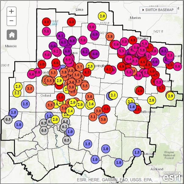
Temperatures (Continued)

     Temp Graph / Graphic #1

     Temp Graph / Graphic #2

               3               3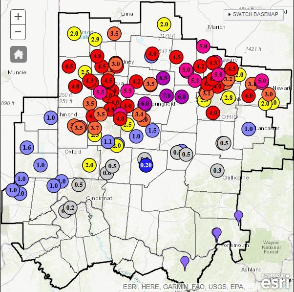
Precipitation
             February was yet another wet month in a recent string of wet months
across the region. Several heavy precipitation events impacted the region – the first
of which stretched from the 6th into the 7th. In fact, severe weather moved through
parts of the area late on the 7th, spawning a weak tornado in Clark County, Ohio.
Widespread rainfall of 2 to 4 inches occurred throughout the region during the 2-
day period – particularly near and south of the Ohio River.
             After only a few dry days, another widespread heavy rain event
impacted the Ohio Valley from the 11th into the 12th, with another round of 2 to 3
inches across parts of the local area. This brought monthly rainfall totals to near 6
inches in parts of the area through only the first 12 days of the month.
             Luckily, following the event from the 11th into the 12th, a somewhat
colder and drier pattern evolved for most of the next week before another heavy
precipitation system moved through on the 20th. A mix of precipitation occurred
with this system from snow, sleet, freezing rain, and rain. Rain moved across the
region on the 23rd in advance of a cold front that moved through during the morning
hours of the 24th. The precipitation ended as some snow flurries and light snow
showers.
             Despite the multiple heavy rain events throughout the first ¾ of the
month, February ended on a slightly drier note, with most of the area receiving only
about 0.5” in the final full week. However, multiple daily precipitation records were
set, and the month ended up being the 4th wettest February at Cincinnati, 6th wettest
at Columbus, and 2nd wettest February on record at Dayton.

                        Total      Departure     Max Daily        Total
                                                                           Max Daily Snowfall
       Site         Precipitation From Normal   Precipitation   Snowfall
                                                                               (in./date)
                        (in.)         (in.)      (in./date)       (in.)

 Cincinnati (CVG)      7.23”       + 4.42”      1.48” 02/20       1.6”     0.5”      02/10

 Columbus (CMH)        5.49”       + 3.24”      1.22” 02/20      11.6”     4.2”      02/01

  Dayton (DAY)         6.15”       + 3.91”      1.91” 02/07       9.4”     4.9”      02/20

                                             4                                           4
Precipitation (Continued)

February Precipitation Departure From Normal

                    Columbus
          Dayton

       Cincinnati

                       5                       5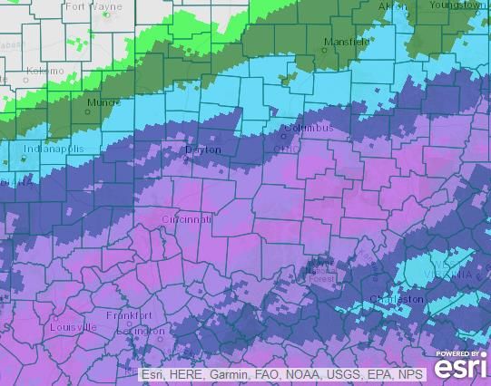
Severe Weather
A tornado was confirmed in Clark County Ohio on February 7th
as a line of storms progressed west-to-east across the region.
The tornado occurred coincident with strong wind fields and
was on the ground for only several minutes. The tornado
occurred from 317-323pm with estimated wind speeds of 80 to
85 mph. The tornado was rated an EF-0. The tornado was on
the ground for 7.5 miles and had a width of 150 yards. Select
damage photos from the NWS storm survey are shown below.

                              6                            6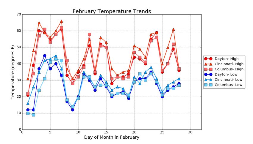
Winter Weather
          A winter storm began to move into the area on
January 31st with a majority of the snow occurring during the
overnight hours on February 1st. Less snow occurred near and
south of the Ohio River with higher amounts near the I-70
corridor.
          A wintry mix of precipitation occurred on February
20th with a mix of snow, sleet, freezing rain, and rain. Several
inches of snow occurred along the I-70 corridor while further
south more of a mix of precipitation occurred, and then
primarily rain near and south of the Ohio River. Once again,
locations near and north of I-70 received considerably more
snow that points further south.
        Jan 31st – Feb 1st                    Feb 20th

                               7                              7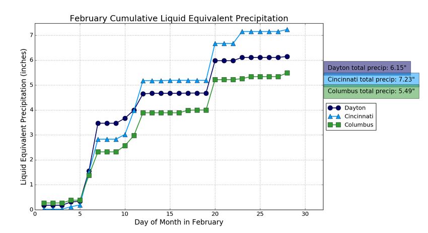
March Outlook
The latest outlook from the Climate Prediction Center (CPC) indicated increased
likelihood of below normal temperatures and above normal precipitation across
parts of the area. However, the Ohio Valley sits right on the edge of the strongest
signals in both categories.

                                                                  Normal         Normal
                        Normal      Normal
   Site      Normal Avg                               Site      Precipitation   Snowfall
                        High (°F)   Low (°F)
              Temp (°F)                                             (in.)         (in.)

Cincinnati                                         Cincinnati
               43.6°F     53.2°F     34.0 °F                       3.96”          3.0”
  (CVG)                                              (CVG)
Columbus                                           Columbus
               41.9°F     51.1°F    32.7°F                         3.02”          4.2”
  (CMH)                                              (CMH)
 Dayton                                             Dayton
               40.4°F     49.6 °F   31.2°F                         3.34 ”         3.4”
   (DAY)                                              (DAY)

 Upcoming Temperature Outlook                       Upcoming Precipitation Outlook

                                               8                                         8
March-May Outlook

The latest outlook from the Climate Prediction
Center (CPC) from March through May, which covers
meteorological spring, indicated increased likelihood
for above normal temperatures across much of the
region. There is a signal for wetter-than-normal
conditions across much of the southern U.S., which
could ultimately spell a slightly wetter-than-normal
spring for parts of the Ohio Valley as well.

     Three-Month (MAM)           Three-Month (MAM)
        Temp. Outlook              Precip. Outlook

                         9                           9
You can also read