PROJECT INDIGO - DOCUMENT, DISSEMINATE & ANALYSE A GRAFFITI-SCAPE
←
→
Page content transcription
If your browser does not render page correctly, please read the page content below
The International Archives of the Photogrammetry, Remote Sensing and Spatial Information Sciences, Volume XLVI-2/W1-2022
  9th Intl. Workshop 3D-ARCH “3D Virtual Reconstruction and Visualization of Complex Architectures”, 2–4 March 2022, Mantua, Italy

 PROJECT INDIGO – DOCUMENT, DISSEMINATE & ANALYSE A GRAFFITI-SCAPE

 Geert Verhoeven1, Benjamin Wild2, Jona Schlegel1, Martin Wieser3, Norbert Pfeifer2, Stefan Wogrin4, Lothar Eysn5, Massimiliano
    Carloni6, Bernhard Koschiček-Krombholz6, Adolfo Molada Tebar7, Johannes Otepka-Schremmer2, Camillo Ressl2, Martina
                                              Trognitz6, Alexander Watzinger6
        1 Ludwig Boltzmann Gesellschaft - LBI ArchPro (Austria), geert@projectindigo.eu / jona.schlegel@archpro.lbg.ac.at
    2TU Vienna - Geo Department (Austria), benjamin.wild / norbert.pfeifer / johannes.otepka / camillo.ressl @geo.tuwien.ac.at
                                         3 Independent researcher, wieser_martin@gmx.at
                                         4 SprayCity (Austria), stefan.wogrin@spraycity.at
              5 City of Vienna, Municipal Department 41 - Surveying and Mapping (Austria), lothar.eysn@wien.gv.at
  6 Austrian Centre for Digital Humanities and Cultural Heritage (Austria), massimiliano.carloni / bernhard.koschicek-krombholz /

                                        martina.trognitz / alexander.watzinger @oeaw.ac.at
7 Polytechnic Univ. of Valencia - Dep. of Cartographic Engineering, Geodesy, and Photogrammetry (Spain), admote@doctor.upv.es

                                                              Commission II

KEY WORDS: graffiti, heritage science, image-based modelling, laser scanning, photography, street art, structure from motion

ABSTRACT:

Graffiti is a short-lived form of heritage balancing between tangible and intangible, offensive and pleasant. Graffiti makes people
laugh, wonder, angry, think. These conflicting traits are all present along Vienna's Donaukanal (Eng. Danube Canal), a recreational
hotspot – located in the city's heart – famous for its endless display of graffiti. The graffiti-focused heritage science project INDIGO
aims to build the basis to systematically document, monitor, and analyse circa 13 km of Donaukanal graffiti in the next decade. The
first part of this paper details INDIGO's goals and overarching methodological framework, simultaneously placing it into the broader
landscape of graffiti research. The second part of the text concentrates on INDIGO's graffiti documentation activities. Given the
project's aim to create a spatially, spectrally, and temporally accurate record of all possible mark-makings attached in (il)legal ways to
the public urban surfaces of the Donaukanal, it seems appropriate to provide insights on the photographic plus image-based modelling
activities that form the foundation of INDIGO's graffiti recording strategy. The text ends with some envisioned strategies to streamline
image acquisition and process the anticipated hundreds of thousands of images.

                     1. INTRODUCTION                                    from colourful murals, anarchistic symbols on bridge pillars to
                                                                        bike stand writings (Figure 1).
Graffiti and street art are multifaceted, 'self-authorised' (Blanché,
2015) forms of personal expression that exploit the public space
using a visual intervention. Graffiti and street art have found their
detractors and admirers, their collectors and destroyers, and even
their superstar artists. In the past three decades, there has been a
considerable expansion of the techniques in which those
'graffitists' express themselves in the public sphere: from graffiti
writing to murals, cut-outs, stencils and stickers (Monschein-
Oberreither, 2019).

This ever-evolving nature and constant need to reinvent itself are
characteristic of graffiti and street art (Lewisohn, 2009; Kimvall,
2014), but they also explain the lack of scholarly agreement on
the scope of these terms. This paper considers 'graffiti' to be the
umbrella term for all mark-making practices, including                  Figure 1. The large variation in graffiti at the Donaukanal.
engravings, paintings, sprayings, stickers, and other personal
expressions attached to public (urban) surfaces in legal or illegal     Every day, new graffiti appear along the Donaukanal. However,
ways. This definition allows us to state that graffiti have been        a graffito's mere creation automatically implies the (complete or
created for millennia (Lovata and Olton, 2015).                         partial) destruction of one or more existing graffiti beneath.
                                                                        Although graffiti are subject to similar post-depositional
Despite its long history, the phenomenon remains fascinating and        processes found on archaeological sites and in landscape
debateable because it continually fluctuates between tangible and       formation, one does usually not 'excavate' a graffiti-scape. Pre-
intangible heritage, between vandalism and art, between                 existing graffiti simply become a lost and forgotten part of the
graphical and textual, between legal and illegal, between               Anthropocene's global stratification (Edgeworth et al., 2014).
subversive and humorous, between pleasingly acceptable and
socio-political criticism. These contradicting features are also        That is why in the summer of 2020, the idea arose to monitor,
present along the Donaukanal (Eng. Danube Canal) in the city            digitally safeguard, and analyse a large part of this unique,
centre of Vienna (Austria). The public surfaces surrounding this        complex, ever-changing, and socially fascinating cultural
central waterway have constituted a graffiti hotspot since the          heritage that flanks Vienna's central waterway. More than a year
early 1980s (Ringhofer and Wogrin, 2018), with works ranging

                                                 This contribution has been peer-reviewed.
                https://doi.org/10.5194/isprs-archives-XLVI-2-W1-2022-513-2022 | © Author(s) 2022. CC BY 4.0 License.                  513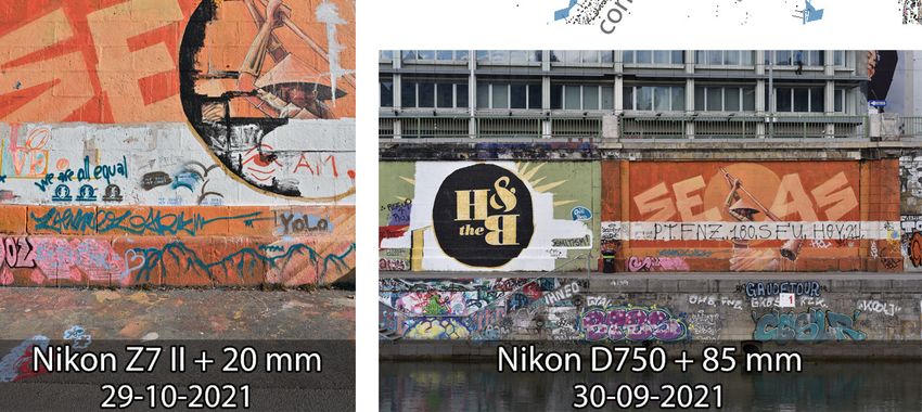
The International Archives of the Photogrammetry, Remote Sensing and Spatial Information Sciences, Volume XLVI-2/W1-2022
  9th Intl. Workshop 3D-ARCH “3D Virtual Reconstruction and Visualization of Complex Architectures”, 2–4 March 2022, Mantua, Italy

later, this concept culminated in the international and                INDIGO thus aims to mirror the real public urban space in the
interdisciplinary academic project INDIGO: IN-ventory and DI-          virtual public space of the internet to digitally preserve and
sseminate G-raffiti along the d-O-naukanal.                            investigate an urban graffiti-scape in time and space. Since this
                                                                       exploration leverages numerous graffiti recordings that digitally
This paper first presents INDIGO's research questions and              encode the stratified graffiti-scape, INDIGO can be considered
objectives, simultaneously discussing how they fit within the          an unconventional archaeological or heritage science project
broader framework of graffiti and archaeological research.             dealing with the contemporary past, much like the 20-year old
Afterwards, the five primary research pillars of INDIGO are            'Graffiti Archaeology' project (Curtis and Rodenbeck, 2004).
summarised. In doing so, the text also outlines the challenges plus
expected results that characterise them. Thereafter, the paper
focuses more on the documentation part of the project by
detailing some of the photographic and image-based modelling
research that takes place in pillars one and two. More specifically,
the first steps towards generating a base 3D model of the whole
research zone are covered, along with some strategies that the
INDIGO team currently explores to acquire and process the
anticipated hundreds of thousands of graffiti photographs.

    2. INDIGO VS EXISTING GRAFFITI RESEARCH

Project INDIGO was launched in September 2021. Funded by the
Heritage Science Austria programme of the Austrian Academy
of Sciences (ÖAW), this two-year project aims to build the basis
to systematically document, monitor, disseminate, and analyse a
large part of the graffiti-scape along Vienna's Donaukanal in the
next decade. INDIGO focuses on nearly 13 km of continuous              Figure 2. The INDIGO research zone in the centre of Vienna.
graffiti-covered urban surfaces between the Friedensbrücke and
Verbindungsbahnbrücke (Figure 2): 5.3 km on the left and 7.6           However, using the words '(contemporary) graffiti' and
km on the right bank. Circa 2/3 of these surfaces are formed by        'archaeology' in one sentence is not something that goes
walls, staircases, bridge pillars and ramps surrounding the            undebated. Already two decades ago, the 'Graffiti Archaeology'
Donaukanal. However, 4.4 km of this graffiti-scape are found just      project (http://grafarc.org) raised many questions regarding the
above the water level on the concrete embankments that contain         definition of archaeology and the discipline's exact subject matter
much of the channel. Strikingly, graffiti are only legal over a        (Patel, 2007). INDIGO takes the stance that archaeology is an
combined stretch of less than 300 m (see Figure 2). In this diverse    academic discipline trying to understand (our complex
research zone, INDIGO operates with three central aims:                relationships with) the material remains of the stratified past,
                                                                       whether that past was centuries (i.e. the remote or ancient past)
1) Documenting the geometrical (i.e. shape and dimensions),            or days (i.e. the contemporary or recent past) ago. And graffiti
   spectral (i.e. colour), geographical (i.e. location), temporal      research aptly illustrates that view because there is a considerable
   (i.e. time of creation and lifespan) and contentual (i.e. subject   overlap between the research aims and methods for prehistoric
   matter and meaning) aspects of this graffiti-scape along            rock art, Roman artefact inscriptions, medieval church carvings
   Vienna's Donaukanal to digitally preserve and monitor this          and present-day mark-making activities like spraying or pasting
   volatile and peculiar cultural heritage.                            stickers (as discussed by Frederick and Clarke (2014)). This
2) Disseminating this distinctive graffiti-scape through the           notion should also transpire in the next section, which describes
   creation of a spatial database and open access online platform      INDIGO's approaches to contemporary graffiti as social practice
   that facilitates interactive, multi-temporal querying and           and cultural artefacts.
   visualisation of all graffiti records.
3) Analysing the (meta)data stored in the spatial database to                      3. ENVISIONED METHODOLOGY
   disclose new socio-political-cultural research questions and
   graffiti-specific insights.                                         INDIGO wants to ensure the digital survival of a large part of
                                                                       Vienna's graffiti-scape and disclose new socio-political-cultural
Usually, anthropologists, sociologists, and art historians cover       insights. To accomplish those aims, INDIGO is structured around
graffiti research. Since these fields place the creator above their    five research pillars: 1) acquisition, 2) processing, 3)
work (Blanché, 2015), proper documentation and monitoring of           management, 4) dissemination and 5) analysis. All of them are
ever-changing graffiti never got the attention some scholars           explained below. The remainder of the paper will then focus on
demanded (Masilamani, 2008). Although online archives like             aspects contained within research pillars 1 and 2.
Global Street Art (http://globalstreetart.com), Urban Layers
(https://www.urbanlayers.city),          Graffiti       Archaeology    1) Acquisition: To provide clean and relevant data for the
(http://grafarc.org) and Art Crimes (https://www.graffiti.org)            spatial database and online platform, i) three-dimensional
exist, they feature partial and biased graffiti records with              (3D) surface geometry of the Donaukanal, ii) photographs of
incomplete, unstandardised metadata (de la Iglesia, 2015). On the         the graffiti, and iii) auxiliary data must be acquired. The 3D
other hand, more comprehensive archives such as INGRID                    surface is vital to remove the geometrical image
(https://www.uni-paderborn.de/forschungsprojekte/ingrid) and              deformations; it is also the backbone onto which the graffiti
SprayCity (https://spraycity.at) lack photographic colour                 images will be mapped for display in the online platform. A
accuracy, extensive metadata querying, 3D visualisation and – in          challenge lies in the acquisition of accurate and complete 3D
the case of INGRID – free access. In other words: INDIGO will             geometry of the canal's banks. Although INDIGO can use
create the first long-term, accurate, exhaustive, open access and         laser scans collected in a mobile mapping campaign part of
interactive archive of graffiti in a vast stretch of urban space.         Vienna's Wien gibt Raum initiative (Eysn, 2020), extra

                                                 This contribution has been peer-reviewed.
                https://doi.org/10.5194/isprs-archives-XLVI-2-W1-2022-513-2022 | © Author(s) 2022. CC BY 4.0 License.                  514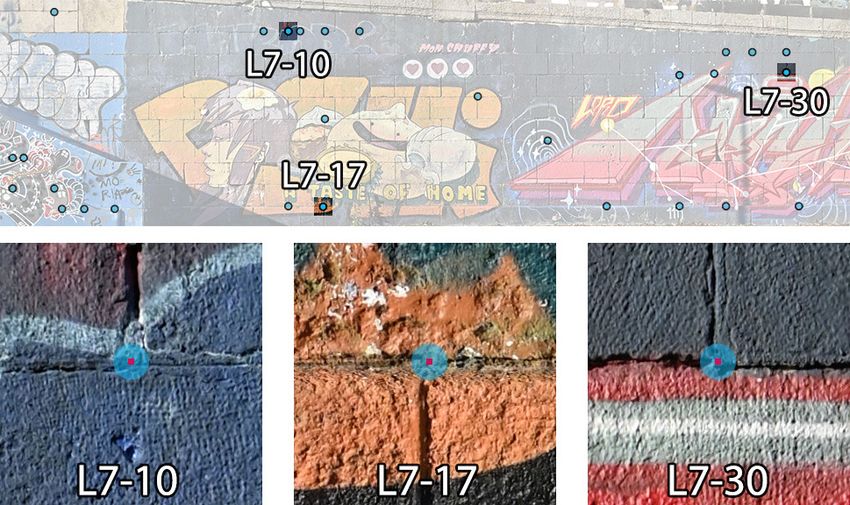
The International Archives of the Photogrammetry, Remote Sensing and Spatial Information Sciences, Volume XLVI-2/W1-2022
  9th Intl. Workshop 3D-ARCH “3D Virtual Reconstruction and Visualization of Complex Architectures”, 2–4 March 2022, Mantua, Italy

    image-based modelling might be needed to avoid potential            4) Dissemination: INDIGO envisions an open-access online
    data gaps that are common in mobile mapping data due to                platform that offers interactive visualisation and exploration
    object occlusions. However, the real challenges relate to              of the data. Textured 3D views should enable visitors to look
    INDIGO's photo acquisition. Colour-accurate photographs                at present-day graffiti in their geographically-correct urban
    should be obtained shortly after the finalisation of each              setting or scroll through time and visually experience the
    graffito. INDIGO solves this last issue via engagement with            works' timespan. A section to browse through detailed
    graffitists and photo tours on an approximate three-day basis.         graffiti orthophotographs plus functions to download and
    A bi-annual photography campaign of the entire research                extensively query (meta)data must also be present.
    zone will allow change detection algorithms to pick up                 Creating such a platform with a slick user experience is a
    graffiti that went unnoticed. However, reliable change                 challenge (e.g. a pleasing layout, smooth data streaming,
    detection, smooth transitions between overlapping images,              robust database integration), but could lead to an augmented
    and graffiti pigment identification all need colour-accurate           reality app in a post-project future. Although articles and
    photographs. Even if hard to achieve outdoors (Verhoeven,              conference talks accomplish international outreach, they do
    2016), INDIGO expects to do better than anyone has                     not instigate the graffitists' essential engagement. The latter
    accomplished so far. Since colour is a function of incoming            is currently conceived via graffiti workshops by SprayCity
    radiation, the latter is measured for every photographed               and regular Instagram posts – Instagram being a vital
    graffito with a spectrometer. Finally, relevant auxiliary data         communication channel for graffitists (MacDowall, 2019).
    must be collected: graffito metadata (like creation date or            In the near future, QR codes tagged along the Donaukanal
    date of first observation, creator, graffiti type) or the videos       could further improve graffiti reporting and increase
    and pictures that graffitists record during spraying. The              awareness, both necessary to extend the foundations laid by
    challenge here lies in collecting all the necessary metadata           INDIGO into the next decade (e.g. via citizen science).
    for every graffito. Many creators prefer anonymity, so the             Finally, INDIGO plans two international symposia: one
    online platform should feature anonymous login for metadata            covering the technical aspects of recording, storing, and
    entry.                                                                 disseminating graffiti, while a second symposium focuses on
                                                                           graffiti's socio-political and cultural impact. Via these
2) Processing: the 3D surface geometry of the Donaukanal, the              symposia, specialists in art history, philosophy, cultural
   graffiti photographs and the auxiliary data must go through             studies, law, urbanism, psychology, and communication will
   one or more processing steps before being inventoried in the            see the potential of this massive open-access archive, thereby
   spatial database. As a start, all datasets receive the necessary        ensuring INDIGO's transdisciplinary sustainability. Both
   metadata (e.g. IPTC tags for the imagery). The photographs              symposia proceedings might also become foundational
   will go through a strict routine to create 16-bit colour-               publications on graffiti research.
   accurate TIFFs (Molada-Tebar et al., 2018). The challenge
   here is to create a robust and repeatable workflow that              5) Analysis: Most of the scholarly literature on graffiti is
   maximises throughput. Afterwards, an orthorectification                 exclusively descriptive, often devoid of essential metadata
   process removes the geometric distortion of the images. To              (e.g. Wacławek, 2011; Reinecke, 2012). This led some
   that end, the 3D point cloud is meshed into a continuous                scholars to blame graffiti research for its overall lack of
   surface. Here, the tricky task awaits of keeping the 3D model           academic rigour (de la Iglesia, 2015). Given the exhaustive
   up to date; some parts of the Donaukanal have a rather                  and spatially + temporally + spectrally impartial inventory of
   dynamic character with temporary structures that come and               graffiti data and metadata, INDIGO's open access archive
   go. INDIGO needs a bespoke tool that can load just the                  will open new analytical pathways for graffiti research that
   necessary mesh segments to create orthophotographs and                  support novel socio-political-cultural research questions. For
   mesh textures. The bespoke software solution should also                instance, Vienna counts several legal spraying surfaces,
   support the change detection operation required by the bi-              jointly labelled Wienerwand (http://www.wienerwand.at).
   annual photographic campaign described in pillar 1, making              Along the Donaukanal, there are approximately 300 m of
   its development challenging. Finally, finding and                       Wienerwand. One may wonder if those who spray in legal
   documenting new graffiti is useless if the resulting data are           graffiti zones have the same profile as those who do not.
   not searchable. Therefore, INDIGO expects this tool (or set             These walls could also offer insight into 'crossing', a
   of tools) to support image segmentation and annotation (e.g.            phenomenon where a major graffito gets scrawled over,
   new graffiti, old graffiti, no graffiti zones) and the attribution      usually by 'tags'.
   of metadata through a spatial database link.                            Analyses like these also directly tie into existing graffiti
                                                                           definitions and classifications. Some scholars and graffiti
3) Management: Collecting and processing data without a solid              creators voice that legally permitted graffiti do not deserve
   data management system is irresponsible. This pillar aims to            the label 'graffiti'. Even though such terminological
   create a spatial database to manage and query all (meta)data.           distinctions do not guide INDIGO's recording, the project
   Besides a robust integration with the online platform (see              must strive for terminological clarity to populate the database
   pillar 4), this database should support spatio-temporal queries         with unambiguous metadata. Creating a graffiti and street art
   and adhere to the CIDOC Conceptual Reference Model                      thesaurus in the first project months will accomplish this.
   (https://www.cidoc-crm.org). At the same time, data entry               Being a finite set of terms (i.e. a controlled vocabulary) with
   should be customisable and painless. Due to the existing                hierarchical relations (Pomerantz, 2015), this thesaurus will
   Vienna-based OpenAtlas software (https://openatlas.eu) and              make INDIGO's graffiti classification explicit and serve as a
   targeted programming, INDIGO expects its database and                   reference for the broader academic graffiti community.
   underlying data model to be exemplary for the Digital
   Humanities at large. Other aspects of this pillar concern            The remaining part of the paper will first focus on the creation of
   managing and hosting the graffiti thesaurus (see pillar 5). To       the 3D geometric backbone, after which it explores different
   tackle the long-term preservation challenges of the project's        strategies to acquire and process new graffiti records.
   digital data, INDIGO has partnered with the CoreTrustSeal-
   certified ARCHE repository (Trognitz and Ďurčo, 2018).

                                                 This contribution has been peer-reviewed.
                https://doi.org/10.5194/isprs-archives-XLVI-2-W1-2022-513-2022 | © Author(s) 2022. CC BY 4.0 License.                  515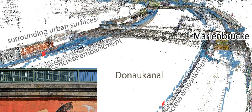
The International Archives of the Photogrammetry, Remote Sensing and Spatial Information Sciences, Volume XLVI-2/W1-2022
  9th Intl. Workshop 3D-ARCH “3D Virtual Reconstruction and Visualization of Complex Architectures”, 2–4 March 2022, Mantua, Italy

              4. 3D GEOMETRIC BACKBONE

INDIGO needs a complete and gap-free 3D surface mesh
(triangle or quad-based) of the Donaukanal onto which all graffiti
photographs can be mapped. Even though this digital surface
might mainly be generated from the mobile laser scanning data
provided by the city of Vienna in 2022, a total photographic
coverage would 1) provide the necessary image data to fill
potential gaps in the laser-scanned 3D point cloud, and
simultaneously 2) constitute a complete record of the graffiti-
scape at a particular moment in time. Since this record would
effectively establish a starting point for tracking change in the
graffiti-scape, all sprayed surfaces (indicated in indigo in Figure
2) were photographed in October 2021 (see Table 1).

The idea was to utilise only one camera model in the project.
Even though the INDIGO cameras did not arrive at the end of
September 2021, the water level in the Donaukanal was low,
which presented a unique opportunity to photograph all graffiti
just above (and in some places below) the usual water level. That
is why this 'total coverage' image acquisition campaign took              Figure 3. The location of all photographs acquired around the
place at the beginning and end of October 2021 using different            Marienbrücke (Marien Bridge) is indicated in semi-transparent
camera setups (see Table 1). Both campaigns only contained                blue. The location of the depicted Nikon Z7 II and Nikon D750
consecutive days to minimise potential graffiti-scape changes             photographs is shown via a red rectangle. The scene's structure is
while acquiring photos (although change was inevitable between            represented by a cleaned cloud of 3D tie points.
both campaigns – see the photographs in Figures 3 and 4). The
following subsection describes this image acquisition in detail.          In total, 26.7k photographs were acquired during both
                                                                          photography campaigns, covering 14 km of graffiti, graffiti-less
4.1 Image acquisition                                                     and unstudied surfaces (Table 2). For instance: graffiti surfaces
                                                                          around the U6 station Spittelau were photographed but the
The first image acquisition mainly targeted the 4.4 km of                 INDIGO team decided later to remove them from the research
reinforced concrete embankment (see Figure 3) that channels a             zone as they are separated from the central zone by 300 m of
large portion of the Donaukanal in the INDIGO research zone               graffiti-less surfaces. Since it was planned to orient all photos
(the channel's bed is only hardened with boulders in the other            with a Structure from Motion (SfM) approach, the image
parts; see Figure 4 on the left). Photographing these concrete            acquisition had to be executed according to specific rules. SfM
walls took place from the opposite bank using an 85 mm lens on            pipelines with camera self-calibration are prone to drift in the
a Nikon D750 24-megapixel full-frame reflex camera. With an               estimated exterior camera orientations or might yield inaccurate
average distance of 51 m between the embankment walls and the             interior orientations, certainly when the photographs do not
D750's detector pitch p of circa 6.0 µm, the mean Ground                  feature a large enough image overlap, or the image collection
Sampling Distance or GSD on these concrete surfaces is 3.6 mm             lacks variation in camera roll angle and fails to include inter- plus
(with all GSD values in the [2.9, 4.8] mm interval, corresponding         intra image scale changes.
to a minimum and maximum embankment separation of 42 m
and 68 m, respectively). This is four times larger than the average       From a practical point of view, this means one should acquire
GSD obtained when photographing the embankment's                          photographs with a camera-lens combination that features a fixed
surrounding urban surfaces (all possible walls, staircases, bridge        focal length and principal distance (i.e. not zooming and not
pillars, and ramps) with the 20 mm lens on the 45-megapixel full-         refocusing). Moreover, the image set must include portrait and
frame mirrorless Nikon Z7 II (see Table 1).                               landscape images (rotated both clock- and anti-clockwise)
                                                                          collected with the optical axis perpendicular as well as inclined
                                              Mean Acquisition    Image
   Date        Camera            Lens
                                              GSD     time        count   to the scene; ideally, the latter is three-dimensional and covers
                                                                          the whole image sensor (Luhmann et al., 2016). Finally, any lens
30/09/2021   Nikon D750       Nikon AF-S             3 h 45 min   2065
               (24.2 MP     NIKKOR 85mm
                                              3.6                         or in-camera vibration reduction should be disabled. More photos
01/10/2021                                    mm     3 h 20 min   2544    are always beneficial because high observational redundancy
             p = 5.95 µm)   1:1.8 G @ f/5.6
26/10/2021                                              7h        6042
                                                                          averages better the interior orientation instability effects that can
27/10/2021   Nikon Z 7II    Nikon NIKKOR Z           7 h 45 min   6591
                                                                          characterise off-the-shelf imaging systems (Fraser, 2013).
                                              0.9
               (45.4 MP       20mm f/1.8 S
28/10/2021                                    mm     3 h 40 min   2856
             p = 4.33 µm)        @ f/5.6                                  INDIGO's total coverage survey applied all recommendations
29/10/2021                                              7h        6608
                                                                          mentioned above. Every day, the focusing ring was immobilised
                                              Total 32 h 30 min   26706   with cellophane tape at a focus distance of circa 4 m (for the Z7
Table 1. Total photographic coverage acquisition parameters.              II) and 50 m (for the D750). The cameras captured 14-bit lossless
                                                                          compressed RAW photos next to in-camera generated JPEGs,
Although INDIGO aims for a GSD of roughly 1 mm in all graffiti            with f/5.6 dialled in for all exposures. This aperture provided
photos, this larger GSD on the embankments is not considered              sufficient depth of field: [23 m, ∞) for the D750 and [1.5 m, ∞)
problematic because most of their graffiti are quite weathered            for the Z7 II given a 30 µm circle of confusion threshold; f/5.6
(see the Nikon D750 image in Figure 3). In addition, one would            also effectuated a very high and uniform lens resolving power.
need to fit the Nikon D750 with a lens of minimally 300 mm (or            However, even adherence to this image acquisition protocol does
220 mm for the Nikon Z7 II), but acquiring images along many              not prevent drift in camera poses (and the resulting network
kilometers with such long-focus lenses is not straightforward.            deformations) when imaging long, elongated scenes (Barazzetti,

                                                 This contribution has been peer-reviewed.
                https://doi.org/10.5194/isprs-archives-XLVI-2-W1-2022-513-2022 | © Author(s) 2022. CC BY 4.0 License.                     516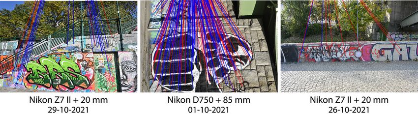
The International Archives of the Photogrammetry, Remote Sensing and Spatial Information Sciences, Volume XLVI-2/W1-2022
  9th Intl. Workshop 3D-ARCH “3D Virtual Reconstruction and Visualization of Complex Architectures”, 2–4 March 2022, Mantua, Italy

2017). The nature and the length of the urban surfaces under                    Usually, the GSD difference between these photos is slightly
study make it hard to avoid a particularly drift-prone image                    higher (a factor five to ten difference for the 85 mm images and
sequence when photographing the banks of the Donaukanal.                        an eight- to fifteen-fold GSD increase for the 20 mm images since
Although scholars proposed extended structural image features                   they are more distant to the opposite bank than the 85 mm
to reduce this endemic SfM issue with long-spanning artificial                  images). Although fewer tie points were found within the set of
structures (Holynski et al., 2020), INDIGO relies on a loop-                    identical focal length images, the central and right examples of
closed multi-camera network and a dense network of control data                 Figure 4 indicate that some ties could still be established.
(see 4.2) to achieve accurate exterior camera orientations.
                                                                                4.2 External photo control acquisition
     Distance type (applicable to the INDIGO project)             Length (km)
              Stretch of Donaukanal researched                                  The image network must be constrained with external photo
                                                                      3.3
           (measured in the centre of the waterway)                             control data to further reduce accumulated drift effects in the
  Buildings-staircases-ramps-bridges with graffiti [left bank]        3.2
                                                                                estimated camera orientations and express the SfM result in a
  Buildings-staircases-ramps-bridges with graffiti [right bank]       5.3       real-world coordinate reference system. The main idea was to
    Buildings-staircases-ramps-bridges with graffiti [total]          8.5       collect the 3D coordinates of numerous Graffiti-scape Points
          Concrete channel embankment [left bank]                     2.1
                                                                                (GPs): object/scene points that are well-identifiable in many
          Concrete channel embankment [right bank]                    2.3       photos (even when potentially sprayed over) and whose long-
            Concrete channel embankment [total]                       4.4       term positional stability can be assumed (see Figure 5). These
                                                                                GPs are collected in 21 clusters: L1 to L9 for the left bank and
         All studied surfaces with graffiti [left bank]              5.3
         All studied surfaces with graffiti [right bank]             7.6
                                                                                R1 to R12 for the right bank of the Donaukanal. L0 denotes the
            All studied surfaces with graffiti [total]               12.9       GPs cluster at a dedicated test area (i.e. where INDIGO methods
                                                                                are tested; see Figure 2); L5 remained unused as it covered an
       Legal graffiti surfaces (Wienerwand) [left bank]               0.2
       Legal graffiti surfaces (Wienerwand) [right bank]              0.1
                                                                                area that the team decided later to exclude from the research zone.
         Legal graffiti surfaces (Wienerwand) [total]                 0.3
         Graffiti-less surfaces photographed [left bank]              0.4
  Graffiti-less & unstudied surfaces photographed [right bank]        0.5
       Graffiti-less surfaces photographed [across banks]             0.2
    Graffiti-less & unstudied surfaces photographed [total]           1.1
  All graffiti, graffiti-less & unstudied surfaces photographed      14.0
Table 2. Some INDIGO-relevant distances.

Loop-closure in the camera network was something specifically
sought after. At three locations, the channel was bridged with
photographs: twice with the 85 mm and once with the 20 mm
configuration. The latter was only possible after photographing
about 400 m of graffiti-less surfaces: trees, benches, and grass
patches (Table 2). However, obtaining loop closure in the 20 mm
image set outweighed the awkwardness of photographing people                    Figure 5. Three typical GPs out of the thirty that constitute
relaxing on benches and staring into the camera. Although                       cluster L7 on the left Donaukanal bank.
INDIGO masks all people appearing on images, everybody was
asked to cover their face or look away if they felt uncomfortable.              During a terrestrial surveying campaign lasting several days, the
                                                                                3D coordinates of many image-identifiable GPs were acquired
                                                                                using free stationing with a Leica Viva TS16 total station and a
                                                                                Leica GPR121 circular prism. The TS16 was freely positioned on
                                                                                twenty locations within the INDIGO research zone (Figure 2).
                                                                                Distances and bearings were measured to at least four and on
                                                                                average to twelve visible Control Network Points (CNPs) from
                                                                                each TS16 location. These points are part of an extensive network
                                                                                of control points established by the City of Vienna during a city-
                                                                                wide terrestrial surveying campaign. They are mainly associated
                                                                                with artificial objects and structures such as drainage covers,
                                                                                edges of walls, or bridge pillars; the coordinates of these CNPs
                                                                                are expressed in the MGI/Austria GK East coordinate reference
                                                                                system (EPSG 31256) and freely available (CC BY 4.0 license)
                                                                                at https://www.wien.gv.at/ma41datenviewer/public/start.aspx.
Figure 4. Metashape established valid image matches (blue
lines) between photographs acquired from opposite sides of the                  Even though the availability and visibility of surrounding CNPs
Donaukanal. Red lines represent rejected tie points.                            largely determined the location of the 21 GP clusters, it was the
                                                                                intention to have approximately equal intervals between them. At
Because the GSD of the 85 mm images is about four to six times                  spots with more massive structures (usually bridges), a GP cluster
bigger than the GSD of the 20 mm images for the same graffiti,                  was established on both sides of the Donaukanal. In between
tie points were anticipated between both image sets despite                     those pairs of clusters, additional clusters alternate between the
possible changes in the graffiti-scape (the left part of Figure 4               left and the right bank (see Figure 2). An orthophoto or textured
confirms this). In addition, many images were acquired in a                     3D model was generated from each location to select and indicate
panorama-like fashion just before and after the bridges to                      the GPs before surveying them (Figure 5). Each cluster counts
establish tie points among the 20 mm photos (as well as the 85                  between 17 and 37 GPs for a total of 593 GPs (see Table 3).
mm ones) acquired on the opposite sides of the Donaukanal.

                                                   This contribution has been peer-reviewed.
                  https://doi.org/10.5194/isprs-archives-XLVI-2-W1-2022-513-2022 | © Author(s) 2022. CC BY 4.0 License.                        517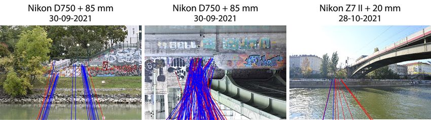
The International Archives of the Photogrammetry, Remote Sensing and Spatial Information Sciences, Volume XLVI-2/W1-2022
  9th Intl. Workshop 3D-ARCH “3D Virtual Reconstruction and Visualization of Complex Architectures”, 2–4 March 2022, Mantua, Italy

4.3 Data processing                                                  to avoid glue residue on the lens. The same protocol was intended
                                                                     for days three and four, but the outer part of the lens got slightly
As stated above, the total station was freely positioned at each     covered by graffiti paint spray on day three and needed to be
cluster to control the visibility of CNPs and GPs. The EPSG          cleaned. Five different interior orientations were thus computed
31256 x and y coordinates of the TS16's centre were calculated       with similar recovered principal distances for each lens: 85.155
using a 2D Helmert transformation followed by a trigonometric        mm and 85.184 mm | 20.412 mm, 20.410 mm, and 20.402 mm.
determination of height to determine the z-coordinate. The
parameters of the Helmert transformation were calculated from        Metashape failed to estimate camera poses for only four photos,
the CNP coordinates, which are known in both the target and the      which is a success given the spectral and spatial invariance of the
source system (a local coordinate system with the total station's    entire scene. The graffiti-scape clearly changed during the four
centre as origin). Because more than two CNPs were available         weeks between the photo campaigns (e.g. Figure 3 and the left
for each cluster, the transformation parameters were determined      side of Figure 4). The image set is also characterised by
by minimising the sum of the squares of the residuals. Residuals     significant illumination changes (sun-lit vs shadowed areas, and
over 4 cm were considered outliers, and these CNPs were              shifting shadows due to moving foliage) and alterations in scene
removed. Table 3 indicates that the average standard deviation of    geometry. Besides the people that are unavoidably photographed
the residuals at all clusters equals 8 mm in planimetry and 12 mm    (occasionally even graffitists at work), new but often temporary
for the z-coordinates. Based on the total station's known position   constructions frequently appear along the channel; ships are also
and the reflectorless measured distances and bearings to the GPs,    passing by, in turn moving the docked vessels. Finally, dust bins,
their 3D coordinates were determined in EPSG 31256. All above-       bikes, e-scooters, and fishermen come and go. This spatial
mentioned geodetic calculations were conducted in IDC EDV's          variability and a minimum of masking notwithstanding,
Geosi Verm v. 21 (https://idc-edv.at/geosi/geosi-verm).              Metashape dealt very well with these unstable tie points.

                                Number of   Measured   GPs used      After visually examining the cloud of 14.5 M 3D tie points for
  Cluster   σxy [mm] σz [mm]    CNPs used     GPs      as GCPs       possible artefacts and ensuring that every camera was
    L0          9        5          9         37          28         approximately in its correct position, the GPs were indicated.
    L1          8       11         10         17          17         This occurred on a cluster-by-cluster basis to identify potential
    L2         13        8          7         30          27         problematic GPs. For every cluster, the respective GPs were
    L3         12       25          5         22          20         indicated in as many D750 and Z7 II photographs as possible.
    L4          8       12          8         30          21         Only a minority of GPs had to be omitted because they could not
    L5         N/A      N/A        N/A        N/A         N/A
                                                                     be accurately indicated in the photos. A few GPs also featured
    L6         10       15          5         23          23
    L7          8       14          7         30          30         larger than average residuals (≥3 cm in object space). As these
    L8          7       10          8         27          26         GPs either represented edges or were located at the border of a
    L9*         3        7         10         23          21         cluster (creating a narrow angle between the laser beam and the
    R1          8        8          4         36          30         surface), their higher residuals are likely due to less accurate GP
    R2         10       13          6         26          23         coordinates resulting from the reflectorless measurements.
    R3          5       15          7         37          29
    R4          7       24          5         30          30
    R5         12        7          4         26          26
                                                                     545 from the 593 GPs were kept (Table 3) after examining each
    R6          8        6          7         26          26         cluster. Combining the precision numbers of Table 3 with an
    R7          4        9          8         32          32         assumed additional uncertainty of ±5 mm to indicate the GPs in
    R8          9       14          5         27          27         the images yields a total precision of about 1.5 cm. This number
    R9          6       22          6         29          29         was used in Metashape to weigh these 545 external observations,
    R10         5       14          7         27          27         so they could function as GCPs (Graffiti-scape Control Points)
    R11        12        6          4         31          30
                                                                     and constrain a final self-calibrating bundle adjustment. This
    R12*        3        7         10         27          23
                                                                     operation mitigated any drift in the recovered camera locations,
 Minimum        3        5          4         17          17         and georeferenced the network of 26.7k photographs. Table 4
 Maximum       13       25         10         37          32
                                                                     presents some accuracy metrics computed from the SfM output.
  Mean          8       12          7         28          26
  Total        N/A      N/A        N/A        593         545
                                                                                    Georeferencing accuracy metric         Value
Table 3. Cluster-specific metrics: the first two columns provide
                                                                                                 RMSEx                     1.1 cm
precision metrics for the derived TS16 centres, computed using
                                                                                                 RMSEy                     1.1 cm
the number of CNPs in column three. The last two columns give                      RMSExy (total planimetric accuracy)     1.6 cm
the number of measured GPs and used GCPs (Graffiti-scape                                         RMSEz                     0.8 cm
Control Points are GPs that constrain the bundle adjustment).                     RMSExyz (total 3D positional accuracy)   1.8 cm
*Observed from the same total station position.                      Table 4. Accuracy metrics for the oriented image network.

All photographs were oriented in Agisoft Metashape Professional      4.4 Future challenges
1.7.5 using a maximum of 25k interest points and 3k tie points
per image. Since most SfM-based image-based modelling                The entire total coverage survey fulfils two aims: 1) it documents
packages establish camera calibration groups solely based on the     the status quo to establish a starting point from which new graffiti
lens' focal length and not its focusing distance, manual             get recorded, and 2) allows to extract 3D surface geometry that
intervention was needed to establish two camera groups for the       can complement the mobile mapping data of the Donaukanal
85 mm photographs and three groups of 20 mm images. For each         from the City of Vienna. It is still unclear how the integration of
group, Metashape computes a set of interior orientation values.      both data sources will occur. The mobile laser scanning data
The 20 mm images were not divided into four groups (i.e. one for     might be filtered and fused with a dense point cloud extracted
every day) because the focusing ring was kept immobile with          from (some of) the photographs; this 3D point cloud can then be
cellophane tape for the first two days (keeping the principal        meshed. Or, the base 3D mesh is extracted from the photos and
distance invariant). At the end of day two, the tape was removed     enhanced with the mobile mapping data. In any case, the

                                                This contribution has been peer-reviewed.
               https://doi.org/10.5194/isprs-archives-XLVI-2-W1-2022-513-2022 | © Author(s) 2022. CC BY 4.0 License.                 518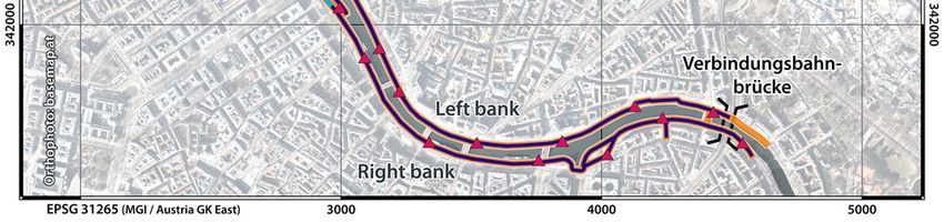
The International Archives of the Photogrammetry, Remote Sensing and Spatial Information Sciences, Volume XLVI-2/W1-2022
  9th Intl. Workshop 3D-ARCH “3D Virtual Reconstruction and Visualization of Complex Architectures”, 2–4 March 2022, Mantua, Italy

generation of one or more clean, error- and gap-free 3D surface         number of new graffiti that weekly appear along the Donaukanal
meshes of the entire research zone will be a time-intensive             and the non-planarity of most surfaces, INDIGO needs a more
operation, not only due to the extent of the research zone, but also    automated solution that ideally generates true orthophotos.
due to its geometrical and spectral invariance.
                                                                        Orthorectification can overcome the issue of surface undulation.
As mentioned in section 4.3, new constructions are often built          This process leverages an object's 3D surface geometry to correct
along the Donaukanal. These surfaces get usually marked with            for relief displacement besides displacements caused by camera
graffiti within a few days after completion, which raises the           tilt, thus creating planimetrically correct true orthophotographs.
question of whether (and when) INDIGO should make a new 3D              In addition, orthorectification applies to any urban surface as long
base model. This is relevant since graffiti on these new urban          as its 3D geometry is sufficiently known. Then again, creating
surfaces can otherwise not be adequately mapped. However,               orthophotos requires knowledge of the camera's in- and exterior
every of these new 3D base models takes time to generate.               orientation parameters, either obtained by extra hardware or via
Finally, these 3D meshes should enable (ortho)rectification and         a separate processing step. The text discusses both options next.
smooth online streaming as textured surfaces. INDIGO explores
ways to decimate and retopologise huge meshes to that end.              5.2 Orthorectification with direct georeferencing

 5. RECORDING AND PROCESSING NEW GRAFFITI                               Approximating the interior and exterior orientations becomes
                                                                        possible by equipping the camera with a Real-Time Kinematic
One of INDIGO's biggest challenges is turning the expected              GNSS receiver paired with an IMU (Inertial Measurement Unit).
100,000s of graffiti photos into absolutely georeferenced, colour-      As in the previous solution, one image per graffito could suffice
accurate, (ortho)rectified photographs and seamless textures for        if the interior camera orientation was predetermined. More
the Donaukanal's 3D model(s), all segmented per graffito and            photos would only be required to ensure a 1 mm GSD for a
accompanied with the correct metadata. Each step comes with             sizeable graffito (because the GSD might become too large when
technical and logistical challenges, and the last part of this paper    encompassing the whole graffito by the camera's field of view).
will shed some light on the three main (ortho)rectification and
georeferencing strategies INDIGO is exploring.                          Compared to planar rectification, this workflow offers a high
                                                                        degree of automation while software requirements can be kept
5.1 Manual (planar) rectification                                       low. However, the dependency on the measurement accuracy of
                                                                        the GNSS/IMU sensors and their cost are a substantial drawback.
A photograph of a planar object is a projective transformation.         INDIGO has tested high-end hardware such as RedCatch's 3D
This photo is perspective distortionless if photographed with a         ImageVector (https://www.redcatch.at/3dimagevector). Still, the
perfect central projection system (i.e. the pinhole model) whose        photo georeferencing accuracy obtainable with such solutions
optical axis is perpendicular to the object. Tilting the optical axis   will often be lower than from a planar rectification. Furthermore,
in any direction induces perspective distortions and a variable         direct georeferencing likely fails at scenes where no exterior
image scale. (Planar) rectification projectively transforms this        orientation parameters can be derived due to obstruction of the
tilted photo to a plane to remove the scale differences.                GNSS signals (e.g. beneath bridges). Finally, suppose a 3D
                                                                        surface model has only been determined once. In that case, it
To determine the eight parameters that characterise the projective      most likely does not incorporate the latest geometric
transformation, one indicates a minimum of four points in the           arrangements of the graffiti surfaces (e.g. newly built staircases).
photograph and object space. However, the assumptions made for
rectified images do not entirely hold for photographs acquired          5.3 Orthorectification with incremental SfM
along the Donaukanal. First, lens distortions are always present.
Although they can be modelled to undistort the photo before             A second, potentially more accurate approach to orthorectify
rectification (Figure 6), this requires extra effort. Second, some      photos in a largely automated way involves the application of
Donaukanal surfaces might visually appear flat. Still, they are         incremental bundle block adjustments. An incremental SfM
slightly curved or feature other deviations from planarity, causing     approach could utilise the oriented photos of INDIGO's total
displacements and scale variations in a rectified image. Even           coverage network to establish the absolute exterior orientation of
though spline algorithms or piecewise affine warpings could             the newly added images. Their interior orientation is concurrently
substitute the projective transformation when surface undulations       estimated by the camera self-calibration part of the SfM pipeline.
are moderate, they cannot eliminate all image displacements.            The camera should also be equipped with a moderately accurate
                                                                        GNSS receiver, ideally complemented by an IMU, to make this
                                                                        approach work reliably and efficiently. This exterior orientation
                                                                        data would help constrain the object space when looking for 3D
                                                                        geometry, older photos, or tie point subsets necessary for the
                                                                        orthorectification and texturing phases. However, this strategy
                                                                        requires the photographer to operate in a particular way. Each
                                                                        graffito must be photographed from several sides, including
                                                                        invariant parts of the surrounding urban fabric. In addition, this
Figure 6. A graffito photo (left) and the error distribution of its     approach's achievability also depends on how INDIGO manages
planarly rectified variants with and without lens distortion (right).   the temporality of tie points. When a new graffito covers another
                                                                        one, tie points originating from the covered graffito should
Although all these methods have the advantage of working with           become invalid. Although this method is still surrounded by
a single photograph and being straightforward to implement in           many open questions and necessitates more specialised software
Python or MATLAB, they also share the disadvantage of being             than the earlier approaches, Figure 7 illustrates its feasibility.
time intensive. Typically, one manually identifies corresponding
points in the image and on the object. A planar rectification of        Instead of an incremental SfM, one could imagine a workflow
one INDIGO photo took, on average, 15 minutes. Given the large          that relies on a local SfM of which the resulting 3D tie points get

                                                 This contribution has been peer-reviewed.
                https://doi.org/10.5194/isprs-archives-XLVI-2-W1-2022-513-2022 | © Author(s) 2022. CC BY 4.0 License.                   519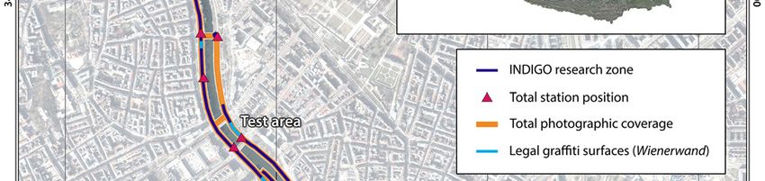
The International Archives of the Photogrammetry, Remote Sensing and Spatial Information Sciences, Volume XLVI-2/W1-2022
9th Intl. Workshop 3D-ARCH “3D Virtual Reconstruction and Visualization of Complex Architectures”, 2–4 March 2022, Mantua, Italy
correctly located and oriented using RTK-GNSS data or via Eysn, L., 2020. City of Vienna's activity in large scale Mobile
Iterative Closest Point. Like the other methods, also this approach Mapping and related image based Artificial Intelligence. In:
presents shortcomings and technical hurdles. However, the final Proceedings CHNT 25. Stadtarchäologie, Vienna.
photo georeferencing process will not only depend on technical
feasibility; integrating the colour-correction, photo segmentation, Fraser, C.S., 2013. Automatic Camera Calibration in Close
and data management pipelines is equally essential. Finally, the Range Photogrammetry. Photogrammetric Engineering &
INDIGO team should not lose sight of its aim to create tools and Remote Sensing 79 (4), 381–388.
workflows useful for the broader heritage documentation field.
Being true to this goal is where the big academic challenge lies. Frederick, U., Clarke, A., 2014. Signs of the times:
Archaeological approaches to historical and contemporary
graffiti. Australian Archaeology 78 (1), 54-57.
Holynski, A. et al. 2020. Reducing Drift in Structure From
Motion Using Extended Features. Proc. of the 2020 International
Conference on 3D Vision (3DV). IEEE, Piscataway, 51-60.
Kimvall, J., 2014. The G-Word. Virtuosity and Violation,
Negotiating and Transforming Graffiti. Dokument Press, Årsta.
Lewisohn, C., 2009. Street art. The graffiti revolution. Tate
Publishing, London.
Lovata, T.R., Olton, E. (Eds.), 2015. Understanding graffiti.
Routledge, Abingdon, New York.
Luhmann, T., Fraser, C.S., Maas, H.-G., 2016. Sensor modelling
and camera calibration for close-range photogrammetry. ISPRS
Journal of Photogrammetry and Remote Sensing 115, 37–46.
MacDowall, L., 2019. Instafame. Graffiti and street art in the
Figure 7. The upper rendering depicts the exterior orientation of Instagram era. Intellect, Bristol.
three photo series; the images below present the 3D texture
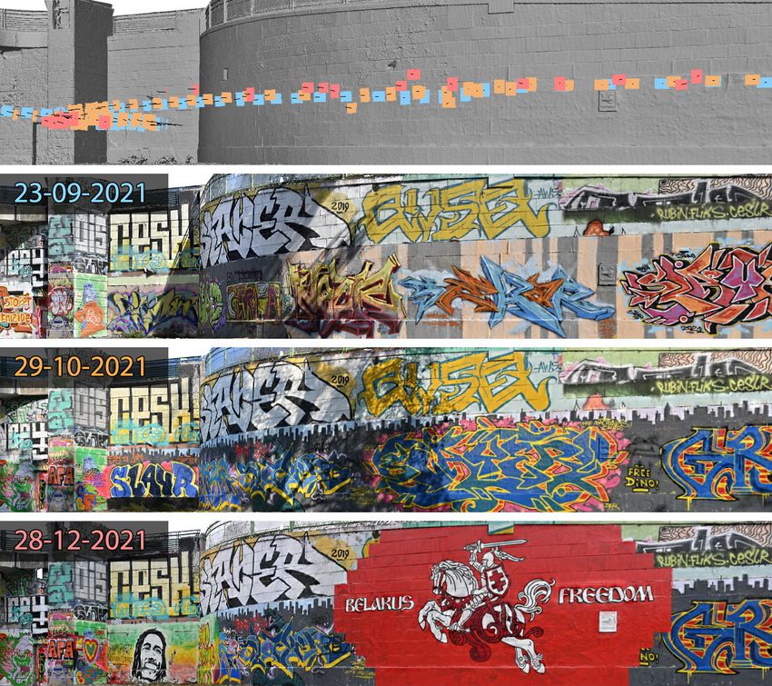
generated from them. Starting from the oriented total coverage Masilamani, R., 2008. Documenting Illegal Art: Collaborative
photos (in orange), Metashape's incremental SfM managed to Software, Online Environments and New York City's 1970s and
orient older September test images (blue) and younger December 1980s Graffiti Art Movement. Art Documentation: Journal of the
photos (pink) despite significant changes in the graffiti-scape. Art Libraries Society of North America 27 (2), 4-14.
6. CONCLUSIONS Molada-Tebar, A., Lerma, J.L., Marqués-Mateu, Á., 2018.
Camera characterization for improving color archaeological
INDIGO wants to ensure the digital survival of a large part of documentation. Color Research & Application 43, 47-57.
Vienna's graffiti-scape via local community engagement and
scientific documentation through time. This paper presented the Monschein-Oberreither, K., 2019. Das politische Graffiti im
project's goals and five-pillar methodology, followed by the road urbanen Raum. Spurensuche im Geographie- und
towards a complete 3D geometric backbone and some thoughts Wirtschaftskundeunterricht. Diploma thesis, Vienna.
on georeferencing vast amounts of new graffiti photos.
Patel, S.S., 2007. Writing on the Wall. The Graffiti Archaeology
ACKNOWLEDGEMENTS Project challenges the definition of archaeology. Archaeology 60.
INDIGO is funded by the Heritage Science Austria programme Pomerantz, J., 2015. Metadata. The MIT Press, Cambridge.
of the Austrian Academy of Sciences (ÖAW).
Reinecke, J., 2012. Street-Art. Eine Subkultur zwischen Kunst
REFERENCES und Kommerz, Second edition. Transcript Verlag, Bielefeld.
Barazzetti, L., 2017. Network design in close-range Ringhofer, A., Wogrin, S., 2018. Die Kunst der Straße – Graffiti
photogrammetry with short baseline images. ISPRS Ann. in Wien. Wiener 428, 46-53.
Photogramm. Remote Sens. Spatial Inf. Sci., 17-23.
Trognitz, M., Ďurčo, M., 2018. One Schema to Rule them All.
Blanché, U., 2015. Street Art and related terms. Street Art & The Inner Workings of the Digital Archive ARCHE.
Urban Creativity Journal 1 (1), 32-39. Mitteilungen der Vereinigung Österreichischer
Bibliothekarinnen und Bibliothekare 71 (1), 217-231.
Curtis, C., Rodenbeck, E., 2004. Graffiti archaeology.
Proceedings of SIGGRAPH 2004. ACM SIGGRAPH, 1. Verhoeven, G., 2016. Basics of photography for cultural heritage
imaging. In: 3D Recording, Documentation and Management of
de la Iglesia, M., 2015. Towards the Scholarly Documentation of Cultural Heritage. Whittles Publishing, Caithness, 127-251.
Street Art. Street Art & Urban Creativity Journal 1, 40-49.
Wacławek, A., 2011. Graffiti and street art. Thames & Hudson,
Edgeworth, M., et al. 2014. Archaeology of the Anthropocene. London.
Journal of Contemporary Archaeology 1 (1), 73-132.
This contribution has been peer-reviewed.
https://doi.org/10.5194/isprs-archives-XLVI-2-W1-2022-513-2022 | © Author(s) 2022. CC BY 4.0 License. 520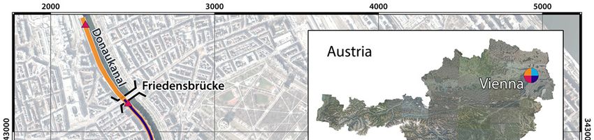
You can also read