Rapid collaborative knowledge building via Twitter after significant geohazard events
←
→
Page content transcription
If your browser does not render page correctly, please read the page content below
Research article
Geosci. Commun., 3, 129–146, 2020
https://doi.org/10.5194/gc-3-129-2020
© Author(s) 2020. This work is distributed under
the Creative Commons Attribution 4.0 License.

Rapid collaborative knowledge building via Twitter after
significant geohazard events
Robin Lacassin1 , Maud Devès1,2 , Stephen P. Hicks3 , Jean-Paul Ampuero4 , Remy Bossu5,6 , Lucile Bruhat7 , Daryono8 ,
Desianto F. Wibisono9 , Laure Fallou5 , Eric J. Fielding10 , Alice-Agnes Gabriel11 , Jamie Gurney12 , Janine Krippner13 ,
Anthony Lomax14 , Muh. Ma’rufin Sudibyo15 , Astyka Pamumpuni16 , Jason R. Patton17 , Helen Robinson18 ,
Mark Tingay19 , and Sotiris Valkaniotis20
1 Université  de Paris, Institut de physique du globe de Paris, CNRS, 75005 Paris, France
2 Université  de Paris, Institut Humanités Sciences Sociétés, Centre de Recherche
Psychanalyse Médecine et Société, CNRS, Paris, France
3 Department of Earth Science and Engineering, Imperial College London, London, UK
4 Université Côte d’Azur, IRD, CNRS, Observatoire de la Côte d’Azur, Géoazur, France
5 European-Mediterranean Seismological Centre, CEA, 91297 Arpajon Cedex, France
6 CEA Centre DAM Ile de France, 91297 Arpajon, France
7 Laboratoire de Géologie, UMR 8538, Ecole normale supérieure, PSL University, CNRS, Paris, France
8 Earthquake and Tsunami Mitigation Division, Indonesian Agency for Meteorology Climatology and Geophysics,

Kemayoran, DKI Jakarta 10610, Indonesia
9 independent researcher: Semarang, Central Java, Indonesia
10 Jet Propulsion Laboratory, California Institute of Technology, Pasadena, California, USA
11 Department of Earth and Environmental Sciences, Ludwig-Maximilians-Universität München, Munich, Germany
12 independent researcher: United Kingdom Earthquake Bulletin, UK
13 Global Volcanism Program, National Museum of Natural History, Smithsonian Institution, Washington DC, USA
14 ALomax Scientific, Mouans-Sartoux, France
15 Local Disaster Management Office (BPBD), Kebumen, Central Java, Indonesia
16 Institut Teknologi Bandung, Jawa Barat 40132, Indonesia
17 Department of Geology, Humboldt State University, California, USA
18 Powerful Earth, UK
19 Australian School of Petroleum, University of Adelaide, Frome Street 5005, Adelaide, Australia
20 Koronidos 9, 42131 Trikala, Greece

Correspondence: Robin Lacassin (lacassin@ipgp.fr)

Received: 22 October 2019 – Discussion started: 28 October 2019
Revised: 30 March 2020 – Accepted: 1 April 2020 – Published: 15 May 2020

Abstract. Twitter is an established social media platform         commented on by geoscientists on Twitter: the Palu Mw 7.5
valued by scholars as an open way to disseminate scientific       earthquake and related tsunami in Indonesia and the long-
information and to publicly discuss research results. Scien-      duration Mayotte island seismovolcanic crisis in the Indian
tific discussions on Twitter are viewed by the media, who can     Ocean. We built our study on a content and contextual anal-
then pass on information to the wider public. Social media is     ysis of selected Twitter threads about the geophysical char-
used widely by geoscientists, but there is little documenta-      acteristics of these events. From the analysis of these two
tion currently available regarding the benefits or limitations    examples, we show that Twitter promotes a very rapid build-
of this for the scientist or the public. Here, we use the exam-   ing of knowledge in the minutes to hours and days following
ple of two 2018 earthquake-related events that were widely        an event via an efficient exchange of information and active

Published by Copernicus Publications on behalf of the European Geosciences Union.
130                                                      R. Lacassin et al.: Rapid collaborative knowledge building via Twitter

discussion between the scientists themselves and the public.       west Sulawesi, Indonesia (Bao et al., 2019; Socquet et al.,
We discuss the advantages and potential pitfalls of this rela-     2019), and the protracted 2018–2019 Mayotte island seis-
tively novel way of making scientific information accessible       movolcanic crisis in the Indian Ocean (Cesca et al., 2020;
to scholarly peers and lay people. We argue that scientific dis-   Lemoine et al., 2019; Feuillet et al., 2020). We analyse the
cussion on Twitter breaks down the traditional “ivory tower”       timelines of Twitter threads from these events to show that
of academia, contributes to the growing trend towards open         a virtual team of scholars sharing complementary data, ob-
science, and may help people to understand how science is          servations, and analyses, and engaging in subsequent discus-
developed and, in turn, to better understand the risks related     sions, may lead to a very rapid co-building of knowledge in
to natural/environmental hazards.                                  just 1 to a few days. This process, which crosses laboratory
                                                                   walls (Britton et al., 2019), has the advantage of being trans-
                                                                   parent to the public and to the media. It makes science acces-
1   Introduction                                                   sible to nonacademics or citizen scientists, who can follow
                                                                   and participate in the discussion. Our findings follow grow-
In the aftermath of a potentially destructive natural event,       ing trends towards open science and also potentially provide
such as a powerful earthquake, tsunami, volcanic eruption, or      the opportunity for a new type of collaborative scientific ap-
major landslide, it is crucial to rapidly determine its key geo-   proach within dynamic and remotely working “global virtual
physical and geological characteristics. With such evidence-       teams” (Zakaria et al., 2004).
based understanding, the geoscientific community can cred-
ibly explain the phenomenon to the media and stakeholders.
Geoscientists can also disseminate the information to peo-         2   Studied events and methodology
ple directly affected by the disaster and engage in discussion
with them (e.g. Stewart et al., 2018). A rapid understand-         For around a decade now, scientists studying natural haz-
ing is also crucial to evaluate the risk of cascading events       ards have been using information extracted from social me-
(e.g. triggered earthquakes), such as the 2016 earthquakes in      dia, websites, or app earthquake reporting to automatically
central Italy (Chiaraluce et al., 2017; Patton, 2016), and to      detect and locate hazardous events, such as flooding (e.g.
direct further scientific action. Decades ago, this understand-    Jongman et al., 2015). Social media posts can also be used
ing was achieved at a much slower pace and within closed re-       to locate earthquakes within tens of seconds of their occur-
search teams by a progressive acquisition of geophysical data      rence (Bossu et al., 2008, 2018; Earle et al., 2010; Steed et
via time-consuming field surveys. This process often took          al., 2019). Here, rather than relying on a quantitative sur-
months to reach a good understanding of the event’s char-          vey based on large-scale keywords or hashtags statistics or
acteristics. Thanks to worldwide geophysical instrument net-       utilizing website traffic analysis combined with geolocaliza-
works (e.g. global and regional seismic networks) and satel-       tion, we built our study on the contextual analysis of quali-
lites (e.g. optical or radar imagery), as well as open data, re-   tative content of selected Twitter conversational threads. We
searchers now generally have enough information to get a           do this to shed light on actual interactions that people have
satisfactory first-order description of the geophysical event      on Twitter during these events, emphasizing the type of in-
and an estimation of its potential consequences within days        formation shared via this social media rather than focussing
(e.g. Hayes et al., 2011). Scholarly interactions via social me-   solely on overarching issues. Examples of recent geologi-
dia, sometimes involving citizen expertise and observations,       cal events that have received extensive Twitter commentary
may transform both the timeliness and the way our geophys-         are the April 2015 Gorkha earthquake in Nepal (see anal-
ical understanding is built and shared (Hicks, 2019; Williams      ysis of Twitter response by Lomax et al., 2015), the Mex-
and Krippner, 2019).                                               ico earthquakes of September 2017, the Mt. Agung eruption
   Twitter stands as a very efficient and simple tool to pub-      of 2017 (Indonesia), the tsunami induced by volcanic col-
licly disseminate scientific information and rapidly engage        lapse at Anak Krakatau (Indonesia) in December 2018, the
in discussion about the cause and implications of geological       July–August 2019 Stromboli eruptions and pyroclastic flows
events (Landwehr et al., 2016; Lee, 2019; Takahashi et al.,        (Italy), the July 2019 Ridgecrest earthquake sequence (Cal-
2015). While Twitter is not the most popular social media          ifornia, USA), and the protracted Lusi mud volcano erup-
platform, compared with platforms such as Facebook (Fal-           tion (Indonesia) that started in 2006. We chose to analyse
lou and Bossu, 2019; Williams and Krippner, 2019), it is val-      two 2018 events that illustrate complementary aspects of
ued by scholars as an interactive and open way to discuss          knowledge building via social media.
research-related issues and to comment on research results in         On 28 September 2018, an magnitude Mw 7.5 earthquake
a concise way (Shiffman, 2017; Van Noorden, 2014). Twitter         occurred in the north-west of Sulawesi island, Indonesia. The
is also widely used by journalists, who can pass on informa-       earthquake ruptured the Palu-Koro Fault system, a north–
tion to the wider public (Engesser and Humprecht, 2015).           south left-lateral fault zone with a relatively rapid average
   Here we use the examples of the 28 September 2018               slip rate of about 4 cm yr−1 (Socquet et al., 2006), which
Mw 7.5 Palu earthquake and the related tsunami in north-           was previously identified as being a high seismic hazard

Geosci. Commun., 3, 129–146, 2020                                                       https://doi.org/10.5194/gc-3-129-2020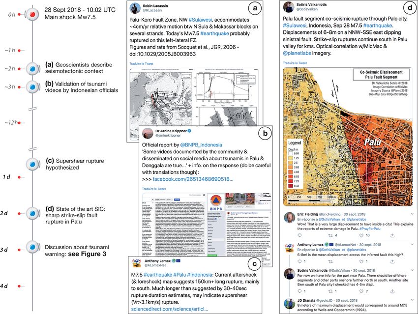
R. Lacassin et al.: Rapid collaborative knowledge building via Twitter                                                         131

zone (Pusat Studi Gempa Nasional – National Center for             fer to this long thread (as for Palu, a PDF print of the full
Earthquake Studies, 2017; Watkinson and Hall, 2017). This          thread is also available from the Figshare data repository:
earthquake triggered a tsunami with run-ups reaching 6–8 m         https://doi.org/10.6084/m9.figshare.11830824.v1). Our pur-
high on the Palu Bay coast (Carvajal et al., 2019; Ulrich          pose is not to carry out the same timeline analysis as for
et al., 2019) as well as widespread liquefaction and surface       the Palu earthquake but to use the “Mayotte 11 Novem-
spreading inland (Valkaniotis et al., 2018; Watkinson and          ber 2018 rumble event” example to outline the efficient
Hall, 2019). To show how key geophysical information was           knowledge-building dialogue between scientists trying to in-
rapidly disseminated and discussed via Twitter, we compiled        terpret a mysterious event and dealing with the uncertainties
informative tweets that were posted about the event’s char-        surrounding it. To illustrate the time evolution of ideas dur-
acteristics and processes. This list of tweets should not be       ing this active dialogue, we generated two word clouds from
considered exhaustive, as it is strongly dependent on who          the selected tweets. We also use the Mayotte case to outline
we follow on Twitter and what is retweeted. We use it to           the role of citizen scientists at the start of the discussion, to
illustrate how this way of spreading information enhances          discuss some pitfalls inherent to using an informal platform
the dissemination and discussion of scientific results. From       like Twitter, and to explore the opportunity to spread infor-
this compilation, we built a timeline of the rapid progress        mation toward more traditional print, broadcast, and online
of the understanding of the earthquake rupture and of its ef-      media.
fects. The timeline (Table A1), which covers the 5 d follow-          The evolution of the two threads was quite different. For
ing the event, is graphically shown in Fig. 1 (see also Ta-        Palu, the scenario was quite well defined and occurred at a
ble S1 in the Supplement, which contains web links to se-          rapid pace over a short amount of time: an earthquake fol-
lected relevant individual tweets). A Twitter “moment” (La-        lowed by a tsunami, with the scientists’ focus being on the
cassin, 2019) gives online access to the full content of the       key observations to explain what happened. For Mayotte, we
tweets including images, maps, and videos (a PDF print of          knew very little at first apart from an initially innocuous seis-
the full thread is also available from the Figshare data repos-    mic swarm followed by the detection of a long-period seis-
itory: https://doi.org/10.6084/m9.figshare.11830809.v1). Ta-       mic signal. There was no accurate location for the signal and
ble S2 provides complementary web links to the Twitter             no idea about what the signal was. This resulted in the Twit-
feeds of several geoscientists who actively participated in the    ter exchanges and the overall thread on Mayotte being more
online data dissemination and discussion in the few days fol-      chaotic and open than the more linear Palu thread. There
lowing the event, giving access to secondary, more detailed        were also very different societal impacts. The Mayotte earth-
discussions.                                                       quakes caused uncertainty, unrest, and stress, but there was
   In contrast to the Palu case, the case of Mayotte, in the       no important damage and no injuries or fatalities. In contrast,
Comoros archipelago between East Africa and Madagascar,            devastation and death were immediately seen in Palu.
represented emergent scholarly interaction over a much more           Most authors of this paper contributed to the Twitter ex-
protracted time period, without direct damage caused by the        changes discussed. Such an “embedded” view has the merit
unrest and lacking initial responses from official government      of providing an in-depth understanding of the geophysical
agencies. The island had been experiencing a long-standing         observations and of the full context of the online exchanges
seismic swarm of volcanic–tectonic origin since May 2018           at the time of the event. To provide an external and more crit-
(Patton, 2018; Lemoine et al., 2019; Feuillet et al., 2020),       ical view, the paper also includes some authors (MD and LF)
but it was not purported to have any significant seismic or        who were not involved in these specific Twitter discussions.
volcanic hazard prior to this crisis. The seismic swarm is still
active more than 18 months later and has recently been linked
                                                                   3     Results: knowledge building and sharing via
to a migration of magma within the lithosphere and the erup-
                                                                         Twitter
tion of an undersea volcano (Cesca et al., 2020; Feuillet et
al., 2020). We do not analyse the full (18 months) Twitter         3.1    The case of the 2018 Palu earthquake
activity related to the Mayotte seismic swarm but instead
focus on a particular long-period seismic event that hap-          Our compilation of the Twitter exchanges following the Palu
pened on 11 November 2018. This event triggered a surge            earthquake and tsunami reveals how we can rapidly gain a
in scholarly Twitter discussions in the following days. The        first-order understanding of event characteristics within a few
surge resulted in a complex and long (> 200 tweets) Twitter        hours to 1 day and a more complete one in less than a week.
thread with many branches opening secondary discussions,           After the initial tweets issued by responding agencies (e.g.
more like a wild bush than a well-structured tree. To sim-         the USGS in the USA and the BMKG in Indonesia), most of
plify this thread, our first aim was to select and regroup the     the exchanges we quote involved academic researchers from
most relevant and informative tweets linked to these discus-       different countries and institutions (see Tables 1, S1) with
sions. We organized these selected tweets into three succes-       specialities encompassing seismology, earthquake geology,
sive Twitter moments that are accessible online (Lacassin,         tectonic geodesy, remote sensing, natural hazards, and sci-
2018a, b, c), and we invite the reader to consult and re-          ence communication. We will not investigate the sociology

https://doi.org/10.5194/gc-3-129-2020                                                     Geosci. Commun., 3, 129–146, 2020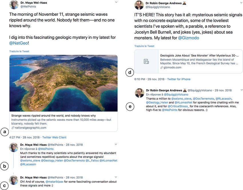
132                                                         R. Lacassin et al.: Rapid collaborative knowledge building via Twitter

Figure 1. Timeline of information posted on Twitter in the hours and days following the Palu earthquake and tsunami of 28 September 2018.
The timeline illustrates the acquisition and dissemination of observations regarding geophysical events and the progress of knowledge build-
ing via Twitter. See Table A1 for detailed information on the timing; Table S1 in the Supplement provides links to relevant tweets and
Twitter accounts; Figs. 2 and 3 display examples of tweets posted by geoscientists. Red dots correspond to information posted by responding
agencies, and blue dots correspond to observations and discussions posted by researchers from different countries and institutions.

of the people involved in the Twitter discussions in more de-                 Minahasa Peninsula on the north-east shore of Palu Bay
tail, because it is outside the scope of the present study, but               (from earthquake location and moment tensor solutions
future work should address this critical subject.                             provided by monitoring agencies, published papers on
   The timeline built from the Twitter feeds (Figs. 1, 2, Ta-                 the seismotectonic context, and regional fault mapping;
ble A1) shows that the geoscience community already knew                      this information was shared via Twitter in the 2 h fol-
the following about 1 day after the earthquake:                               lowing the event – see Fig. 2a);

  i. the earthquake happened on the Palu-Koro Fault sys-                  ii. the rupture entered Palu Bay, but the geometry of its
     tem, with a sharply localized strike-slip rupture directly               prolongation offshore toward the Minahasa Peninsula
     beneath Palu City, and the epicentre was located in the                  was uncertain (from early post-earthquake satellite im-

Geosci. Commun., 3, 129–146, 2020                                                              https://doi.org/10.5194/gc-3-129-2020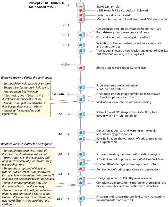
R. Lacassin et al.: Rapid collaborative knowledge building via Twitter                                                                    133

Figure 2. Screenshots of tweets chosen to illustrate how researchers shared and explained observations regarding the Palu earthquake and
tsunami of 28 September 2018. A simplified timeline (from Fig. 1) is shown on the left for reference. (a) Within 2 h geoscientists described
the seismotectonic context of the earthquake. (b) Geoscientists shared and translated the official validation of viral videos about the tsunami
in Palu. (c) Researchers hypothesized supershear rupture. (d) Geoscientists shared satellite image correlation results showing a sharp rupture
with a 5 m left-lateral offset across Palu town, and other researchers started to discuss these results. Refer to Fig. 3 for tweets about the
tsunami warning.

     agery and preliminary image correlation using pre- and                 v. there was dramatic surface spreading and liquefaction
     post-event data);                                                         in and south-east of Palu City (from photos and videos
                                                                               shared by locals).

 iii. the aftershock zone extended ∼ 150 km in the north–                    The exchanges and discussions continued via Twitter, and
      south direction, and the mainshock hypocentre was lo-               by 5 d after the earthquake the geoscientific community had
      cated near the northern tip of this zone (from operational          assembled a fairly accurate description of the event and its
      earthquake locations provided by monitoring agencies);              effects. The acquired common and credible knowledge was
                                                                          as follows:

 iv. a tsunami with run-ups of several metres hit the shores                 i. the earthquake ruptured two strands of the Palu-Koro
     of Palu Bay but was not recorded out of the bay (from                      Fault system for a total length of ∼ 150 km (from the af-
     reports and videos shared via social media by local peo-                   tershock distribution provided by monitoring agencies,
     ple and the tide gauge records that were available in the                  radar and optical image analysis results, and early earth-
     hours following the event – see Fig. 2b);                                  quake source models);

https://doi.org/10.5194/gc-3-129-2020                                                             Geosci. Commun., 3, 129–146, 2020
134 R. Lacassin et al.: Rapid collaborative knowledge building via Twitter
ii. the strand south of Palu Bay had a sharp and extremely the discussion, providing, for example, tide gauge records
localized surface rupture with sinistral offsets of ∼ and field observations of fault surface rupture and offsets.
5 m (from satellite imagery and state-of-the-art pre-and This created the opportunity to develop new international
post-event image correlation, which was later confirmed collaborations. Further highlighting the use of social media,
by field observations posted on Twitter by Indonesian an analysis of the tsunami source by Carvajal et al. (2019)
researchers ∼ 15 d after the event – see Fig. 2d); used videos posted on social media platforms such as Twitter
and YouTube.
iii. the rupture started on an inland fault east of Palu Bay The spread of information via Twitter was not restricted
and then crossed Palu City from north to south (from to a small group of geoscience scholars. Journalists used and
satellite and InSAR imagery as well as early earthquake quoted these Twitter discussions in their articles (e.g. An-
source models); drews, 2018a; Wei-Haas, 2018a), using the thread to iden-
iv. the earthquake rupture propagated unilaterally south- tify academic experts to interview for their articles. How-
ward, likely at a supershear speed (faster than S waves), ever, some journalists were not interested in the full range of
which was a fairly unique observation for earthquakes geophysical observations and focussed instead on a “failed
(from early earthquake source duration and rupture tsunami alert” (Fountain, 2018; Wright, 2018). Based on an
length estimates, with the latter based first on the distri- Associated Press (AP) dispatch, on 1 October 2018, quoting
bution of early aftershocks and then on satellite images some scientists (Wright, 2018), there were inaccurate reports
– see Fig. 2c); from international media outlets about a “failed” tsunami
warning. According to these reports, a network of tide gauges
v. massive liquefaction and lateral spreading occurred in and buoys would have been able to issue an early tsunami
several sectors of Palu City (from aerial video footage warning after the earthquake, thereby saving lives. The me-
shared by local government agencies, satellite imagery, dia were quick to blame the Indonesian authorities, saying
and photos and videos shared by locals on social me- that such a warning would have been impossible because the
dia); Indonesian buoy network was not well maintained. However,
geoscientists realized that there was not enough time to issue
vi. tsunami waves hit the Palu Bay coast only a few minutes
any warning given the very short distance between the earth-
after the earthquake (from tide gauge records and videos
quake source and the areas exposed to the tsunami in the very
shared on social media).
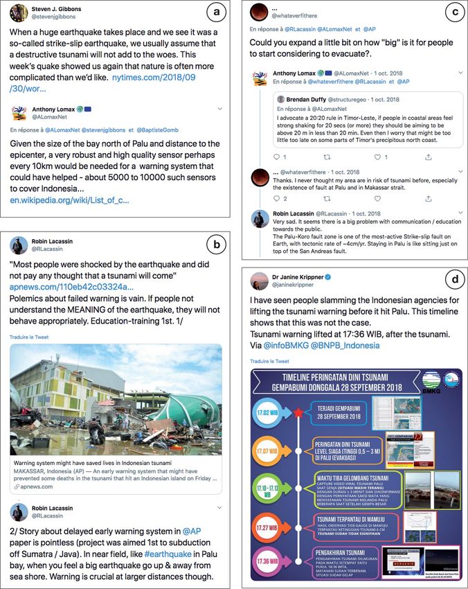
narrow Palu Bay (Fig. 3). As stated by Carjaval et al. (2019),
Ensuing Twitter exchanges during the next weeks focussed “the most remarkable features of the tsunamis that devastated
on the surface rupture description in the field by Indonesian Palu were the very short, nearly instantaneous arrival times”.
scientists, the bathymetry of Palu Bay, the possible fault ge- The first tsunami waves indeed hit the coast between 1 and
ometry across it, and hypotheses about the tsunami source. 2 min after the earthquake. After the evidence-based expla-
These hypotheses explored whether the tsunami was due to nation given by scholars on Twitter (Fig. 3), the process of
the seismic rupture itself, due to underwater landslides and fact-checking by some journalists took only a few hours af-
coastal collapse, or due to a combination of the two. ter the publication of the AP dispatch (e.g. Morin, 2018).
In this process of common knowledge building, geosci- As described above, the case of the Palu earthquake and
entists used a diverse range of data types that were openly tsunami provides an excellent example of how scholarly dis-
shared and discussed on Twitter: published papers and maps cussions on Twitter can provide initial and rapid scientific re-
about the seismotectonic context, teleseismic data, local seis- sults, whilst also reinforcing local official authorities on the
mic waveforms, high-resolution optical satellite images, syn- ground and helping to guide journalistic outputs.
thetic aperture radar (SAR) satellite data analysis, tide gauge
records, and field observations from both science groups and 3.2 The Mayotte 11 November 2018 rumble event
local residents. Data sharing and social interaction via Twit-
ter appeared to be an effective way of getting prompt and On 11 November 2018, more than 6 months after the start of
diverse feedback from fellow researchers on early scientific an earthquake swarm between Madagascar and the Comoros
ideas. The satellite image correlation results, available on archipelago in the Indian Ocean, a peculiar seismic signal
Twitter 1–2 d after the earthquake, were then rapidly shared radiated from the region of Mayotte. The signal was recorded
as a more formal report via the open repository zenodo.org worldwide by seismic networks, but it was not detected by
(Valkaniotis et al., 2018). Some ideas and initial hypotheses their automatic event identification algorithms because of its
about a supershear rupture and the offshore fault geometry odd spectral characteristics. It was an unusually long, low-
in Palu Bay, both discussed on Twitter, provided impetus for frequency, highly monochromatic signal, like a low-pitched
accelerated development of in-depth scientific papers (Bao et hum that travelled as seismic waves across the Earth.
al., 2019; Ulrich et al., 2019). Indonesian geoscientists, ab- As noted by journalist Maya Wei Haas in her National Ge-
sent from the earlier scholarly exchanges on Twitter (only of- ographic article “only one person noticed the odd signal on
ficial agencies were providing advice), progressively joined the U.S. Geological Survey’s real-time seismogram displays.
Geosci. Commun., 3, 129–146, 2020 https://doi.org/10.5194/gc-3-129-2020R. Lacassin et al.: Rapid collaborative knowledge building via Twitter 135 Figure 3. Screenshots of selected tweets about the tsunami warning in the case of Palu. (a, b) Geoscientists quote media articles regarding a possible “failed” tsunami warning and explain that such a warning was extremely difficult in the case of the Palu earthquake (see text for more details). (c) An example of geoscientists engaging in discussion with local people. (d) A geoscientist reports that Indonesian agencies issued an alert in due time and cancelled it only after the tsunami hit Palu. https://doi.org/10.5194/gc-3-129-2020 Geosci. Commun., 3, 129–146, 2020
136 R. Lacassin et al.: Rapid collaborative knowledge building via Twitter
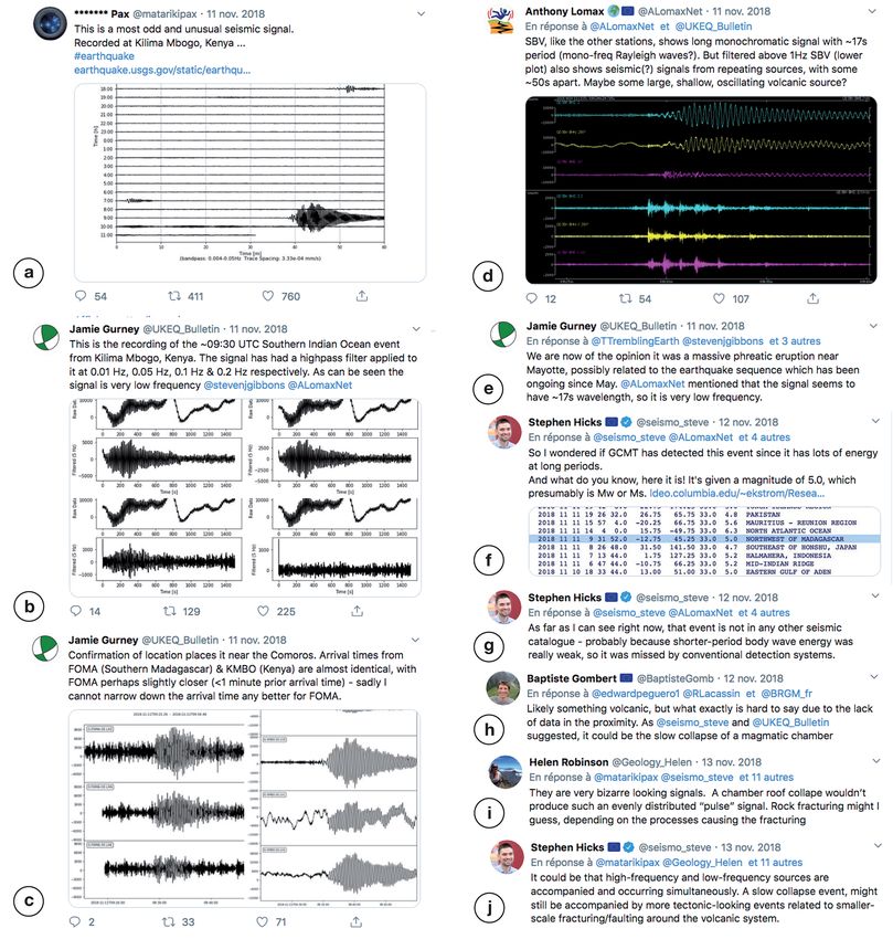
An earthquake enthusiast [. . . ] saw the curious zigzags and surveys on the Mayotte earthquake swarm (Nathalie Feuillet,
posted images of them to Twitter” (Wei-Haas, 2018b). This personal communication to RL, 2018).
image (Fig. 4a) was then retweeted by a citizen earthquake The full interactive process on Twitter was the subject of
researcher, Jamie Gurney, who initiated an active discussion two long articles in National Geographic (Wei-Haas, 2018b)
between academic researchers (Fig. 4), with some interac- and Gizmodo (Andrews, 2018b), with journalists gathering
tions from the media and the public. Analysis of openly ac- information and contacting researchers via Twitter before in-
cessible seismic waveform data from around the world by terviewing them via email or phone (Fig. 6). These articles
seismologists then confirmed the signal originated in the were then used as primary sources by other media and stim-
Mayotte region (e.g. Hicks, 2018a). ulated stand-alone reports by more traditional news organi-
The Twitter discussion involved a group of seismologists zations (e.g. Sample, 2018).
but also specialists in earthquake geology, volcanology, tec- The long thread about the Mayotte 11 November seis-
tonics, geodesy, geomechanics, hazards, and science com- mic event reveals the efficiency of knowledge building via
munication. Their exchanges eventually co-built a rapid ap- scholarly online interactions, but it also outlines some pit-
praisal of the 11 November signal and of its broader geophys- falls that are inherent in the informal aspect of exchanges via
ical and geological context. The nature of the researchers’ Twitter. While after the Palu earthquake and tsunami geosci-
interactions are exemplified by the three successive Twit- entists were posting solid observations (i.e. “knowns”), for
ter moments (Lacassin, 2018a, b, c) that regroup our com- Mayotte they were trying to understand a peculiar event with
pilation of tweets (see Fig. 4 for a choice of tweets illus- large uncertainties, thereby opening many secondary discus-
trating the early discussion between researchers). A simple sions about “unknowns”. The resulting “bushy” nature of the
content analysis of the selected tweet threads, illustrated by thread makes it difficult to follow and comprehend in real
the two successive word clouds in Fig. 5, shows how the ex- time, and summarizing it a posteriori is challenging. More-
changes started with questions about the odd seismic signal over, some of these secondary discussions were casual or
itself (using words such as signal, event(s), wave(s), seismic, humorous and were at risk of being seen as insensitive and
and frequency) and its geographic origin (using words such taken out of context by the general public. We infer that sci-
as Mayotte and location) (Fig. 5a) and then moved to a dis- entific Twitter exchanges dealing with uncertainties and un-
cussion more focussed on the event’s geophysical source (us- knowns, as for Mayotte, are more prone to such pitfalls than
ing words such as source, signal, CMT, CLVD, and deforma- those sharing knowns.
tion) and data processing (using words such as data, model,
InSAR, and inversion) (Fig. 5b). While many things remain
4 Discussion: advantages and pitfalls of Twitter for
to be understood about the geophysical processes at work
knowledge exchange and co-building
offshore of Mayotte, the preliminary waveform modelling
shared via Twitter (Hicks, 2018b) and the related discussion 4.1 Argument 1: very rapid co-building of knowledge
resulted in the consensus hypothesis that the 11 November
seismic signal was due to a deflation event in a large and deep The two case studies described above support previous work
magmatic chamber combined with resonance and amplifica- showing that Twitter allows the rapid building of knowledge
tion of the seismic waves. This early hypothesis discussed on (e.g. Choo et al., 2015; Hicks, 2019). In the case of the 2018
Twitter was subsequently supported by later in-depth analy- Mw 7.5 Palu earthquake, it took only 5 d to obtain a de-
ses (Lemoine et al., 2019; Cesca et al., 2020; Feuillet et al., tailed description of the events and only a few days for the
2020). 11 November 2018 seismovolcanic event in Mayotte. It takes
The Twitter interactions on Mayotte drew the attention of several months to years for scientific teams to gather relevant
the global geoscience community. Before the 11 November information, analyse it, and publish it in an academic jour-
event, the long-standing earthquake swarm near Mayotte had nal after a long review–revision process. Thus, using Twitter
been largely ignored; the swarm had only been studied by makes information and basic explanations accessible to the
only a few researchers, mainly French, because Mayotte is scientific community and to the public more quickly. Com-
a French territory. As noted by Lemoine et al. (2019) , the municating such ideas to the public may have a high im-
11 November event “awakened the interest of the seismolog- pact in places where operational infrastructure and associ-
ical community and the media”. We understand that the rapid ated communication are limited. Moreover, Twitter provides
“explosion” of the informal Twitter discussions that we re- direct and early scientific information for researchers, with-
port played a pivotal role in this awakening and helped hasten out any geographical and institutional barriers, acting as a
needed research in the region (Hicks, 2019). A few days after “science news feed” that can be used to plan further in-depth
the 11 November event, at a meeting between the French geo- research.
science community and stakeholders (funding agencies and However, the knowledge built via Twitter is not exactly
ministry representatives), the Twitter exchanges were used to comparable to the knowledge built by a longer-term, classi-
demonstrate the urgency with respect to funding research and cal academic approach. Even if a long practice of research
allows scientists to estimate the quality of a data set or of a
Geosci. Commun., 3, 129–146, 2020 https://doi.org/10.5194/gc-3-129-2020R. Lacassin et al.: Rapid collaborative knowledge building via Twitter 137 Figure 4. Screenshots illustrating early Twitter exchanges about the very long-period seismic signal near Mayotte on 11 November 2018. The selected screenshots show that Twitter discussion was initiated by citizen scientists (a–c) and then progressively involved academic researchers (d–f). Those researchers then started an active discussion about the seismic signal and its possible origin (e–j). methodology almost immediately (if not intuitively), it does be believed and on what ground? The fact that the author of not substitute peer review as a process to check the validity a tweet comes from a recognized expert institution increases of a result and “establish” knowledge. Therefore, a question his/her credibility. Nevertheless, this is not enough to ensure arises regarding the credibility and legitimacy of the knowl- the scientific quality of his/her tweet – and the reverse is also edge built rapidly and without peer review via Twitter: can it true. As shown in the Mayotte example, nonpractising re- https://doi.org/10.5194/gc-3-129-2020 Geosci. Commun., 3, 129–146, 2020
138                                                          R. Lacassin et al.: Rapid collaborative knowledge building via Twitter

                                                                       Twitter discussions. By widening stakeholder interactions,
                                                                       such open discussions may also help to enhance the schol-
                                                                       arly value of open data sets.
                                                                          A risk to sharing “breaking science” information on Twit-
                                                                       ter and social media is that this same information can en-
                                                                       able publications by the global community before the lo-
                                                                       cal scientists who provided the initial information. There are
                                                                       vulnerabilities for those field teams who are committing re-
                                                                       sources as part of a response initiative and are required to,
                                                                       or feel a duty to, provide timely public information about
                                                                       an event. Elements of such a scenario unfolded following
                                                                       the 2016 Kaikōura earthquake in New Zealand, when tweets,
                                                                       blog posts, and media releases by the responding agencies
                                                                       were an important information source for an early publica-
                                                                       tion by researchers without collaboration with the responding
                                                                       agency scientists. This publication (Shi et al., 2017) predated
                                                                       publications of field observations and analysis by teams on
                                                                       the ground by several months. This example raises questions
                                                                       about the ownership of scientific knowledge that is shared
                                                                       in the public domain and suggests that some scientists may
                                                                       choose to completely restrict, or be more selective about,
                                                                       publicly posting their scientific analysis into the public do-
                                                                       main.

                                                                       4.2   Argument 2: science beyond the laboratory

                                                                       Twitter allows us to step outside the laboratory in many
                                                                       ways. First, it opens the door to professional networking and
Figure 5. Word clouds illustrating the evolution of topics discussed   new academic collaborations between scientists from differ-
on Twitter after the Mayotte 11 November 2018 very long-period         ent disciplines, institutions, or even countries. In the case of
(VLP) seismic event. The top word cloud (a) illustrates the first      the Palu earthquake, most of the early exchanges involved
60 tweets of the selected Twitter moment with most frequent words      non-Indonesian academic researchers; Indonesian geoscien-
regarding the VLP signal (signal, event(s), wave(s), seismic, and      tists then joined the discussion and provided data that could
frequency) and its geographic origin (Mayotte and location). The
                                                                       only be acquired locally (e.g. field observations about the
bottom word cloud (b), which corresponds to the subsequent 60
                                                                       earthquake rupture or liquefaction-induced landslides). This
tweets, shows a discussion more focussed on the geophysical source
of the VLP event (source, signal, CMT, CLVD, and deformation)          led them to engage in a discussion with other members of
and data processing (data, model, InSAR, and inversion).               the international scientific community and paved the way for
                                                                       new collaborations, such as the sharing of tsunami source
                                                                       models for operational hazard analyses. In the short term,
                                                                       however, it might be difficult for local scientists to get in-
searchers and “hobby scientists” can develop a good scien-             volved in social media if they are busy with the management
tific understanding and can legitimately discuss these topics          of the crisis and/or collecting the first information from the
(Fig. 4). Thus, the following question arises: how can we en-          field. Furthermore, scientists from local monitoring organiza-
sure that the most qualified comments receive the most atten-          tions or universities may have strict social media usage and
tion?                                                                  communication policies.
    Rapid dissemination of early scientific analysis products             Twitter also opens the door to exchanges with the global
(for example, using up-to-date remote sensing data) to sci-            public. The scientific value of contributions from nonaca-
entists working in the field is another aspect of using social         demics varies between examples, but there are always some
media platforms. This use of social media is similar to the            external inputs that help to clarify or reframe the scientific
modern trends of using preprint servers for early sharing of           questions and the way to explain them to the public. Nonaca-
scientific results. Twitter interaction is now also forming the        demics can launch important discussions. In the case of May-
basis of collaborations, leading to the development of ideas           otte, it was a citizen scientist who drew attention to a strange
and the subsequent co-writing of papers within diverse, mul-           seismic signal (Fig. 4a), and it was the subsequent “explo-
tidisciplinary teams, e.g. Hicks et al. (2019) and Ulrich et           sion” of informal Twitter discussions that woke the scientists
al. (2019) included co-authorships that were instigated from           and the authorities up (Lemoine et al., 2019; Hicks, 2019).

Geosci. Commun., 3, 129–146, 2020                                                           https://doi.org/10.5194/gc-3-129-2020
R. Lacassin et al.: Rapid collaborative knowledge building via Twitter 139
Figure 6. Screenshots of tweets by journalists Maya Wei-Haas and Robin George Andrews. After promoting their media article on the
Mayotte 11 November 2018 event (a, d), the journalists acknowledged academic researchers who were first identified and contacted via
Twitter and then interviewed via email or phone (b, c, e).
Among Twitter users, journalists “listening in” are particu- 4.3 Argument 3: opening the scientific process to the
larly important as they can pass on some of the scientific public
content of the discussions in an understandable way. The
challenge for them is to have access to information that is The process of knowledge building on Twitter is open and
as fresh as it is credible. From this point of view, Twitter is public, which may help to improve the general public’s and
an important resource because it can serve as a pool of po- the media’s understanding of how scientific research works.
tential experts to give in-depth comment (Fig. 6). Conversely, The examples described above show that the process of
perhaps this trend reduces the diversity in these pools, with knowledge co-construction is not linear. Some discussion
public comment favouring scientists on Twitter rather than threads might look like well-structured “trees” (e.g. the Palu
those who avoid Twitter and/or use other social media plat- earthquake) but others resemble “wild bushes” with many
forms. Moreover, how much checking does a journalist do to secondary branches of discussions opening up over time (e.g.
assess a tweeter’s scientific credibility? the Mayotte seismovolcanic crisis). Scientists are seen by
the public to use a wide variety of data and following in-
direct, unchronological, and unstructured thought paths be-
fore reaching a conclusion. As a window to the scientific pro-
cess, Twitter also helps to clarify that scientific work is orga-
nized into disciplines and subdisciplines and that the knowl-
https://doi.org/10.5194/gc-3-129-2020 Geosci. Commun., 3, 129–146, 2020140 R. Lacassin et al.: Rapid collaborative knowledge building via Twitter
edge and know-how of these groups may be difficult to ar- 5 Concluding remarks
ticulate, but they are all necessary to build a global view of
a subject. Scientists themselves are familiar with these as- Using examples of Twitter discussions following two very
pects of their work but non-scientists may not be, largely be- different geophysical events, we have shown that open sci-
cause scientific knowledge is often presented retrospectively entific discussion and hypothesis building on social media
as having been constructed in a cumulative and chronologi- can promote and enhance many key aspects of modern sci-
cal manner. Epistemologists have long denounced this mis- ence, including the development of ideas for future project
conception (e.g. Kuhn, 1996). Thus, Twitter can contribute funding, early dissemination and discussion of preliminary
to making the “messy part of science” more tangible and vis- results forming the basis of peer-reviewed publications, net-
ible. Early information on Twitter can also provide excellent working for developing international collaborations, demon-
teachable material for educators. strating the impact of research, and public dissemination of
One limitation is that the thread has to be “visible” on research and results. Twitter can be seen as a modern method
Twitter, using a proper hashtag for instance. Also, if the pub- of crowdsourcing scientific ideas; however, this can raise
lic is not aware of the sphere and the discussion is not ”vis- moral issues over the proper acknowledgement of how these
ible” to them, they will not see it even though it is public. ideas were progressively developed. In these concluding re-
Moreover, some schools of thought, especially those from marks, we combine the results from the present study with
a public safety standpoint, may argue that scientists should our own experience on social media to identify some interest-
concentrate on disseminating the certainty of known, well- ing questions and implications for modern scientific methods
established facts and interpretation about a hazardous event, and communication.
rather than on communicating uncertainties and cutting-edge Our analysis has shown that Twitter discussions do not
research (e.g. Jones, 2020). It is our view that scientists must represent a significant change over the common methods
reach a careful balance between knowledge building and be- adopted in traditional scientific research. For example, sci-
ing sensitive to a damaging geohazard event very soon after entific discussions on Twitter may be compared to traditional
it has happened. in-lab scholar discussions at coffee time and encounters at
scientific conferences that are a usual way of exchanging in-
4.4 Argument 4: helping people to understand hazards formation and new ideas. Twitter democratizes such schol-
and risk mitigation arly interactions by expanding their interdisciplinarity and
geographic coverage, leading to more diverse scientific in-
Improving people’s understanding of natural phenomena can puts. Many of these differences result from an increase in
help to improve risk mitigation, at least indirectly. For ex- open data, a willingness to openly share ideas, and the glob-
ample, in the case of the Palu earthquake, the international alization of science. Moreover, in the examples described in
media insisted that a ”failed” tsunami warning was responsi- this paper, the group of scientists involved in the discussions
ble for the associated fatalities, but scientists quickly realized had not previously worked together. They formed a group
and explained that there was not enough time to issue an ef- with a diverse range of backgrounds and with different ex-
ficient alert because of the proximity of the earthquake (see pertise, questioning previous tweets, thereby providing an ef-
above). In fact, the Indonesian agency in charge (BMKG) fective and rapid analogue to traditional peer review.
issued an alert a few minutes after the event and then can- Nevertheless, there are key differences compared with
celled it ∼ 30 min later (Fig. 3d, Table A1); in the meantime, the traditional scientific method that we should be wary of.
the tsunami hit the Palu Bay coasts (Krippner, 2018). Later Whilst we have demonstrated that the use of Twitter for sci-
the same day, BMKG issued a press release to explain their entific knowledge building and dissemination can be a ful-
alert management process. This contradictory information is filling experience, the immediate tangible benefits for sci-
likely to open a debate that will improve the general public’s entists that may be needed for, e.g. career progression, may
understanding of what to expect (or not) from early-warning not be obvious. For example, research managers less accus-
systems. More generally, by bringing facts and evidence- tomed to science on social media may find such efforts to
based arguments into the public debate, the scientific com- be a distraction from traditional research work. The current
munity can contribute to the quality of people’s information academic system rewards scientists mostly based on peer-
and, in the long-term, help people to prepare. Twitter discus- reviewed publications, so how can scientists be rewarded
sions are opportunities to prevent confusion and misunder- for such public dissemination and preliminary groundwork?
standing by reinforcing and disseminating information and Also, what happens if research papers are published that use
advice given by local government agencies (Bartel and Bo- the scientific ideas developed on Twitter without appropriate
hon, 2019). credit? How can credit be given to the incremental develop-
ment of scientific ideas from Twitter?
Based on our experience, as science on Twitter is con-
ducted fully in the public domain, we should be wary of
comments being taken out of context and the potential of
Geosci. Commun., 3, 129–146, 2020 https://doi.org/10.5194/gc-3-129-2020R. Lacassin et al.: Rapid collaborative knowledge building via Twitter 141
posts to “go viral”. As a Twitter user gains followers, their Together with the growing popularity of open science and
responsibility and the risk of such issues dramatically in- preprint archives, discussing science on Twitter can impor-
creases, and as the number of comments/replies from follow- tantly fill in the traditional “radio silence” from science be-
ers grow, so does the time required to reply responsibly. In tween a newsworthy/impactful event and the publication of
such cases, should this public-facing approach be left to so- related scientific papers that follows months to years later.
cial media and public relations experts? Alternatively, should Our study has specifically focussed on potentially hazardous
media and communication training become a standard for geological events, but our experiences reported here can as-
scientists working in fields with public-facing aspects? sist the usage of social media for many other fields of re-
Aside from occasional conspiracy theorists and charlatan search.
earthquake/volcanic eruption predictors, we have found from
our experience of Twitter that communicating about natural
geohazards can be less affected than other topics by the well-
recognized disadvantages of the platform - such as trolling
and personal abuse. However, challenges still remain for the
scientific discussion and dissemination of more controversial
subjects, such as human-induced seismicity, petroleum sci-
ence, or climate change. Does exposing the “messy part of
science” (see above) help to increase public trust in scien-
tific evidence? For example, it might be possible for some
people to clearly see the uncertainty in some scientific ar-
guments and to “prey” on them for political gain. Overall,
opening up the scientific processes and involving the general
public as stakeholders should help to improve trust in ex-
perts. Future development of “best” practices for scientists
involved in such subjects will be needed. However, offer-
ing communication training is only one step toward support-
ing scientists in the effective conveyance of their work. Cur-
rent issues like climate change show us that scientists need
to be openly communicating and building trusting relation-
ships with global communities, but, at the same time, the re-
sponse from a minor group of other scientists can be hostile
and damaging. We need to specifically acknowledge and re-
ward scientists for these crucial efforts and keep working to
change the culture to support science communicators.
https://doi.org/10.5194/gc-3-129-2020 Geosci. Commun., 3, 129–146, 2020142 R. Lacassin et al.: Rapid collaborative knowledge building via Twitter
Appendix A
Table A1. Timetable of main events and preliminary geophysical information posted on Twitter about the Palu earthquake and tsunami of
28 September 2018 (Table S1 provides links to the relevant tweets).
Important event, information, or result Tweeted by (@nnn Time posted Day posted
refers to the Twitter account) (hh:mm UTC) (UTC)
Foreshock Mw 6.1 (USGS location and time) 07:00 28 Sep 2018
Main shock Mw 7.5 (USGS location and time) 10:02 28 Sep 2018
BMKG first tsunami alert @infoBMKG 10:07 28 Sep 2018
BMKG tweet mainshock @infoBMKG 10:09 28 Sep 2018
Preliminary first motion mechanism: strike-slip @ALomaxNet 10:16 28 Sep 2018
USGS tweet mainshock @USGSBigQuakes 10:20 28 Sep 2018
BMKG cancel tsunami alert @infoBMKG 10:36 28 Sep 2018
Strike-slip moment tensor e.g. @geoscope_IPGP 10:47 28 Sep 2018
Seismotectonic context: strike-slip rupture on Palu- Several 12:00 28 Sep 2018
Koro Fault, a major fault system with a ∼ 4 cm yr−1
long-term rate (comparable to the San Andreas Fault)
First viral videos of tsunami in Palu Several 12:00 28 Sep 2018
(unverified and not validated at this time)
Confirmation of the tsunami and the official validation e.g. @AP quoting Indonesian agency; 13:00 28 Sep 2018
of viral videos @janinekrippner; @Sutopo_PN
Seimotectonic map showing past seismicity @CPPGeophysics 15:20 28 Sep 2018
Tide gauges: very weak signal out of Palu Bay – not e.g. @RLacassin 15:37 28 Sep 2018
working at Pantaloan in the bay itself
BMKG press release about tsunami alert and why they @infoBMKG 00:40 29 Sep 2018
ended it
Synthetic poster of seismotectonic context and seismic- @patton_cascadia 01:07 29 Sep 2018
ity
Supershear rupture hypothesized (will be confirmed @ALomaxNet; @DocTerremoto
later)
Planet Labs imagery suggests rupture right in Palu town @SotisValkan 13:40 29 Sep 2018
First rough Planet Labs satellite image correlation (SIC) @SotisValkan 14:04 29 Sep 2018
reveals fault rupture in Palu (results will go viral)
Videos of dramatic surface spreading/liquefaction (will e.g. @janinekrippner; @pat- 15:33 29 Sep 2018
become viral) as will the ensuing discussion ton_cascadia
About 1 d after earthquake, we already know
the following: Earthquake on the Palu-Koro Fault system with sharply
localized strike-slip rupture in Palu town itself; the rupture
enters the bay north of Palu (but it is uncertain how it prolongates
offshore and northward); the aftershock zone extends for ∼ 150 km
in the north–south direction, and the mainshock is near its northern tip.
Tsunami with run-up of several metres in Palu Bay
(not out of the bay) with dramatic surface spreading
and liquefaction in and south-east of Palu town
State-of-the-art SIC: localized strike-slip rupture in Palu @SotisValkan 09:52 30 Sep 2018
with ∼ 5 m of coseismic slip (will go viral)
Geosci. Commun., 3, 129–146, 2020 https://doi.org/10.5194/gc-3-129-2020R. Lacassin et al.: Rapid collaborative knowledge building via Twitter 143
Table A1. Continued.
Updated SIC map of rupture in Palu and displacement @SotisValkan 16:10 30 Sep 2018
profile
Discussion in the international media and social net- Several 06:00 1 Oct 2018
works about a “failed” tsunami warning
Geoscientists explain that a tsunami warning was very Several 09:00 1 Oct 2018
difficult in the case of the Palu earthquake
Satellite imagery: surface spreading/liquefaction (con- e.g. @davepetley; @StefLhermite 12:24 1 Oct 2018
firmed by video footage) and the tsunami impact
Map of coseismic displacement now for 20 km south of @SotisValkan 17:44 1 Oct 2018
Palu (from Planet Labs SIC)
Surface spreading measured with SIC @SotisValkan 10:09 2 Oct 2018
Wider SIC map from Sentinel-2 imagery: rupture ex- @SotisValkan 16:45 2 Oct 2018
tends >50 km south of Palu
SIC with Landsat images: confirms sharp rupture ex- @TTremblingEarth 18:11 2 Oct 2018
tending 65–85 km south of Palu
First InSAR interferogram (from ALOS-2 satellite) @planet_mech 19:21 2 Oct 2018
covering whole rupture
Aerial video footage of massive surface spreading and @Sutopo_PN 21:16 2 Oct 2018
destruction south-east of Palu
Tide gauge record in Pantaloan now available; @marufins; @ALomaxNet; @RLa- 12:45 3 Oct 2018
tsunami’s first arrival was only a few minutes after cassin
earthquake – ∼ 2 m height
Complete SIC map (Sentinel-2 imagery): rupture step- @SotisValkan 15:57 3 Oct 2018
ping onshore east of Palu Bay; implies complex connec-
tion across the bay; epicentre at the northern tip of the
rupture.
Validated InSAR interferogram and along-track dis- @GSI_chiriin 09:53 5 Oct 2018
placement map, covering whole rupture (from ALOS-2
satellite)
Known and unknown 8 d after earthquake: The earthquake ruptured two strands of the Palu-Koro Fault system
for a total length of ∼ 150 km: one strand south of Palu bay,
with extremely sharp localized surface rupture and sinistral
offsets of ∼ 5 m. It crosses Palu town and enters the bay to
the north. However, the rupture does not continue straight
northward – it steps eastward to continue inland.
Earthquake rupture started to the north at the hypocentre and
propagated southward, likely at a supershear rate. Massive
surface spreading is documented from satellite imagery.
Tsunami waves hit Palu Bay coast few minutes after the
earthquake. Polemics about a “failed” tsunami warning is in vain.
First results of surface rupture field survey by Indone- @pamumpuni 20:42 13 Oct 2018
sian geologists
https://doi.org/10.5194/gc-3-129-2020 Geosci. Commun., 3, 129–146, 2020144 R. Lacassin et al.: Rapid collaborative knowledge building via Twitter
Data availability. PDF prints of the full threads Bao, H., Ampuero, J.-P., Meng, L., Fielding, E. J., Liang, C.,
of selected tweets are available from the Figshare Milliner, C. W. D., Feng, T., and Huang, H.: Early and persistent
data repository for the Palu earthquake and tsunami supershear rupture of the 2018 magnitude 7.5 Palu earthquake,
(https://doi.org/10.6084/m9.figshare.11830809.v1, Sup- Nat. Geosci., 12, 200–205, https://doi.org/10.1038/s41561-018-
plement 1) and for the Mayotte VLP seismic event 0297-z, 2019.
(https://doi.org/10.6084/m9.figshare.11830824.v1, Supplement 2). Bartel, B. and Bohon, W.: The Hazards of Hazard Communication:
Importance, Rewards, and Challenges of Science in the Public
Sphere: A white paper summary of presentations from session
Supplement. Table S1 lists the main geophysical events and in- PA23B at the 2018 Fall Meeting of the 485 American Geophys-
formation shared via Twitter after the Palu event, with links to rel- ical Union, available at: https://www.iris.edu/hq/files/ (last ac-
evant tweets. Table S2 provides web links to the Twitter feeds of cess: 8 May 2020), 2019.
geoscientists who participated in the online data dissemination and Bossu, R., Mazet-Roux, G., Douet, V., Rives, S., Marin, S., and
discussion after the Palu event. The supplement related to this ar- Aupetit, M.: Internet Users as Seismic Sensors for Improved
ticle is available online at: https://doi.org/10.5194/gc-3-129-2020- Earthquake Response, Eos, Transactions American Geophysi-
supplement. cal Union, 89, 225–226, https://doi.org/10.1029/2008eo250001,
2008.
Bossu, R., Roussel, F., Fallou, L., Landès, M., Steed, R.,
Author contributions. This paper follows exchanges on Twitter Mazet-Roux, G., Dupont, A., Frobert, L., and Petersen,
after the Palu and/or Mayotte events in which most of the authors L.: LastQuake: From rapid information to global seis-
participated. JG and DFW, as citizen scientists, alerted the scien- mic risk reduction, Int. J. Disast. Risk Re., 28, 32–42,
tific community to the Mayotte 11 November event and translated https://doi.org/10.1016/j.ijdrr.2018.02.024, 2018.
Indonesian geohazard information in English respectively. RL con- Britton, B., Jackson, C., and Wade, J.: The reward and risk of
ceived the study and compiled and analysed the data. All authors social media for academics, Nat. Rev. Chem., 3, 459–461,
commented on the results. RL, MD, and SPH wrote the paper with https://doi.org/10.1038/s41570-019-0121-3, 2019.
input from all co-authors. Carvajal, M., Araya-Cornejo, C., Sepúlveda, I., Melnick, D., and
Haase, J. S.: Nearly Instantaneous Tsunamis Following the
Mw 7.5 2018 Palu Earthquake, Geophys. Res. Lett., 46, 5117–
5126, https://doi.org/10.1029/2019GL082578, 2019.
Competing interests. The authors declare that they have no con-
Cesca, S., Letort, J., Razafindrakoto, H. N. T., Heimann, S., Ri-
flict of interest.
valta, E., Isken, M. P., Nikkhoo, M., Passarelli, L., Petersen, G.
M., Cotton, F., and Dahm, T.: Drainage of a deep magma reser-
voir near Mayotte inferred from seismicity and deformation, Nat.
Acknowledgements. This paper is a collaborative study follow- Geosci., 13, 87–93, https://doi.org/10.1038/s41561-019-0505-5,
ing Twitter discussions between co-authors. It is dedicated to the 2020.
late Sutopo Purwo Nugroho, former chief spokesperson of the In- Chiaraluce, L., Di Stefano, R., Tinti, E., Scognamiglio, L.,
donesia disaster mitigation agency (BNPB), for his open communi- Michele, M., Casarotti, E., Cattaneo, M., De Gori, P.,
cation toward the public, in particular via Twitter. Robin Lacassin’s Chiarabba, C., Monachesi, G., Lombardi, A., Valoroso, L.,
position is funded by CNRS (Centre National de la Recherche Sci- Latorre, D., and Marzorati, S.: The 2016 Central Italy Seis-
entifique, France). Part of this research was performed at the Jet mic Sequence: A First Look at the Mainshocks, After-
Propulsion Laboratory, California Institute of Technology under shocks, and Source Models, Seismol. Res. Lett., 88, 757–771,
contract with the National Aeronautics and Space Administration. https://doi.org/10.1785/0220160221, 2017.
We thank Christopher Jackson and Beth Bartel for their detailed Choo, E. K., Ranney, M. L., Chan, T. M., Trueger, N. S.,
and helpful reviews. This study contributes to the IdEx Université Walsh, A. E., Tegtmeyer, K., McNamara, S. O., Choi, R.
de Paris ANR-18-IDEX-0001. This is IPGP contribution no. 4140. Y., and Carroll, C. L.: Twitter as a tool for communi-
cation and knowledge exchange in academic medicine: A
guide for skeptics and novices, Med. Teachnol., 37, 411–416,
Review statement. This paper was edited by Mathew Stiller- https://doi.org/10.3109/0142159X.2014.993371, 2015.
Reeve and reviewed by Christopher Jackson and Beth Bartel. Earle, P., Guy, M., Buckmaster, R., Ostrum, C., Horvath, S.,
and Vaughan, A.: OMG Earthquake! Can Twitter Improve
Earthquake Response?, Seismol. Res. Lett., 81, 246–251,
References https://doi.org/10.1785/gssrl.81.2.246, 2010.
Engesser, S. and Humprecht, E.: Frequency or Skillful-
Andrews, R. G.: Indonesian Tsunami: What Happened, How To ness: How professional news media use Twitter in
Survive One, And How To Help, Forbes, 1 October, available at: five Western countries, Journalism Stud., 16, 513–529,
https://www.forbes.com/sites/robinandrews/ (last access: 5 July https://doi.org/10.1080/1461670X.2014.939849, 2015.
2019), 2018a. Fallou, L. and Bossu, R.: Taking into account the cultural con-
Andrews, R. G.: Geologists Joke About “Sea Monster” After Mys- text to improve scientific communication – Lessons learned
terious 30-Minute Rumble Emanates from Waters Near Mada- from earthquakes in Mayotte, EGU Seismology, available at:
gascar, Gizmodo, available at: https://gizmodo.com/ (last access:
5 July 2019), 2018b.
Geosci. Commun., 3, 129–146, 2020 https://doi.org/10.5194/gc-3-129-2020You can also read