Recommendations for Aquatic Organism Passage at Maryland Road-Stream Crossings - June 2021
←
→
Page content transcription
If your browser does not render page correctly, please read the page content below
Recommendations for Aquatic Organism Passage
                   at Maryland Road-Stream Crossings

                                                        June 2021
                                                 MARCH 2021
Jeff Gring | [SCHOOL]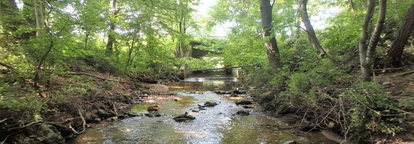
ACKNOWLEDGEMENTS
This guidance document and associated recommendations were developed by Coastal Resources, Inc. in
collaboration with a stakeholder group consisting of members of the Chesapeake Bay Program’s Fish
Passage Work Group and members from other state agencies, federal agencies, and conservation groups.
Participating members of the stakeholder group and their affiliations are as follows: Julie Devers (USFWS),
Mary Andrews (NOAA), Ray Li (USFWS), Sandy Davis (USFWS), Seth Moessinger (Trout Unlimited),
Katherine Stahl (USFWS), Meghan Fullam (ACOE), Nora Bucke (MDOT SHA), Steve Minkkinen (USFWS),
Leah Franzluebbers (USFWS), Greg Golden (MD DNR), Jim Thompson (MD DNR), Serena McClain
(American Rivers), Dana Havlik (MDOT SHA), Andy Kosicki (MDOT SHA), Tim Rosen (Shore Rivers), Cathy
Bozek (USFWS), Mark Secrist (USFWS), Sarah Widman (MD DNR), Rich Mason (USFWS), Gwen Gibson (MD
DNR), Jesus Morales (USFWS) and Julianna Greenberg (Chesapeake Bay Program). Julie Devers
represented the Fish Passage Work Group as the project lead. Initial drafts of this guidance document
were also reviewed by members of the MDOT SHA-MDE Hydraulics Panel. The following members of the
Hydraulics Panel provided valuable recommendations, some of which were incorporated into the current
document: Art Parola, Eric Brown, Wilbert Thomas, Drew Atland, Ward Oberholtzer, and Kaye Brubaker.
In addition to their participation in the review of this document, the Hydraulics Panel and representatives
from MDE and MDOT SHA have been working to address aquatic organism passage (AOP) design issues.
The results of their AOP studies will be published in research reports and will inform future revisions of
the MDOT SHA Hydrology and Hydraulics Design Manuals by both the Office of Structures and Office of
Highway Development.

The text and figures throughout this document are unique, however, the concept of this document and
its general layout follow the 2nd edition of the “Massachusetts Stream Crossings Handbook”, published in
2012 by the Massachusetts Division of Ecological Restoration and biodrawversity LLC
(www.biodrawversity.com). Writing and design for this document was completed by Jeff Gring of Coastal
Resource, Inc. Unless otherwise noted, all photos in this document were taken by the author. Additional
figures and diagrams were created by Jenny Saville and Samantha Moxey of Coastal Resources, Inc. and
cannot be reproduced without permission. On the cover page, the bottomless culvert photo was provided
by the USFWS (unknown photographer) and the brook trout photo was taken by Ryan Hagerty (USFWS).

This project has been funded wholly or in part by the United States Environmental Protection Agency
under assistance agreement CB96341401 to the Chesapeake Bay Trust. The contents of this document do
not necessarily reflect the views and policies of the Environmental Protection Agency, nor does the EPA
endorse trade names or recommend the use of commercial products mentioned in this document.
1    Recommendations for Aquatic Organism Passage at Maryland Road-Stream Crossings

    BACKGROUND AND PURPOSE
    Members and associates of the Chesapeake Bay          manual and cannot be used as a standalone
    Program’s Fish Passage Workgroup, from state and      reference to successfully replace or install a
    federal agencies and non-profit organizations,        culvert. The crossing recommendations presented
    began meeting during the spring of 2018 with the      are intended to be used in conjunction with sound
    intent to increase the number of fish-friendly        engineering and design practices in accordance
    culverts in Maryland. Many agencies and               with all state and federal regulations. Additional
    organizations throughout the United States, and       project and site considerations should occur early
    particularly in the northeast, have increased their   in the planning and design process, including
    efforts to remove instream barriers to ensure that    owner agency design objectives, considerations,
    fish can migrate upstream and downstream in           and constraints. Potential objectives and
    rivers and streams to access habitat important        constraints include permit requirements, working
    during various life stages. This group first          within the roadway right-of-way, an analysis of
    inventoried what Maryland and other states were       design alternatives, capital and life-cycle costs,
    doing to ensure that road-stream crossings allow      risk-based decision making (e.g., public safety,
    for fish passage. They next invited a speaker to      environmental, etc.), use of sound science and
    inform the group about how Massachusetts is           engineering approaches, and constructability.
    approaching aquatic connectivity at road-stream
                                                          The main goal of this document is to present
    crossings. The “Massachusetts Stream Crossings
                                                          Maryland stream crossing recommendations to
    Handbook” and related stream crossing standards
                                                          promote stream continuity, aquatic organism
    have served as the basis for stream crossing
                                                          passage, and in some cases, terrestrial wildlife
    recommendations and guidelines used by several
                                                          passage. Local conservation groups, city and
    other states throughout the eastern United States.
                                                          county engineers, highway departments, resource
    Subsequently, the group met with individuals from
                                                          agencies, and the general public can use this
    agencies in Maryland that review permits for road-
                                                          document to help promote stream continuity
    stream crossings (i.e., bridges and culverts) to
                                                          throughout Maryland.
    discuss their review and permitting process.
    Following this meeting, the group determined that     These recommendations were developed based
    there was a need for communication tools,             on a literature review of over 90 sources and
    including      a    document      that    provides    coordination and review by a stakeholder group
    recommendations for aquatic organism passage at       consisting of members of the Chesapeake Bay
    road-stream crossings in Maryland.                    Program’s Fish Passage Work Group and members
                                                          from other state agencies, federal agencies, and
    This document is meant to inform local
                                                          conservation groups. The Additional Resources
    conservation groups, city and county engineers,
                                                          section at the end of this document provides
    highway departments, resource agencies, and the
                                                          resources to aid in the implementation of the
    general public on the importance of stream
                                                          recommendations provided in this document.
    continuity to the health of Maryland streams. This
                                                          Finally, the Definitions section at the end of this
    document also provides recommendations for
                                                          document defines the italicized terms used
    crossing structures to improve or maintain aquatic
                                                          throughout the document.
    organism passage along non-tidal waterways. This
    document is not a technical handbook or design

                                                                                                 June 2021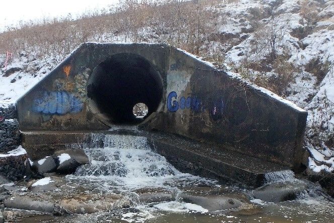
2    Recommendations for Aquatic Organism Passage at Maryland Road-Stream Crossings

    INTRODUCTION
    Maryland contains over 10,000 miles of freshwater     Passage Workgroup has committed to opening an
    streams and rivers, with the majority draining to     additional 1,000 miles of stream and subsequently
    the Chesapeake Bay. Maryland’s waterways are          132 miles every two years for these target species
    exceptional for their beauty, ecological              by 2025.
    importance, and recreational value. The diverse
                                                          When not properly designed, crossings can impede
    stream and habitat types found throughout the
                                                          movement of migratory fish species, fragment
    state support a unique and broad range of aquatic
                                                          populations of resident aquatic organisms, and
    fauna, such as fish, salamanders, turtles and
                                                          degrade water quality and aquatic habitat quality
    freshwater mussels. Similar to much of the United
                                                          through the alterations of flow and sediment
    States, land use changes have historically impacted
                                                          transport. However, stream continuity, or the
    aquatic habitats in Maryland, from indirect effects
                                                          uninterupted connection of a river network, is not
    on water quality associated with watershed
                                                          always the primary consideration when designing
    development to aquatic migration barriers
                                                          road-stream crossings. Other project objectives,
    associated with roadways.
                                                          such as providing safe transport for the public,
    Fragmentation of aquatic habitats by dams,            providing flood conveyance, and adhering to
    culverts, and other infrastructure is a primary       financial constraints may be prioritized over
    threat to aquatic species throughout the United       aquatic organism passage.
    States. The need to improve aquatic connectivity
                                                          The removal of aquatic barriers located along free-
    in the Chesapeake Bay watershed has been the
                                                          flowing waterways can have numerous ecological
    focus of government agencies and other
                                                          benefits, including increasing biodiversity,
    environmental groups for decades. From 1989 to
                                                          improving floodplain and riparian function, and re-
    2013, the Chesapeake Bay Program’s Fish Passage
                                                          establishing migratory routes and habitat access
    Workgroup has implemented dam removal and
                                                          for aquatic organisms. In addition, properly
    fish passage projects that have opened over 2,500
                                                          designed crossings and design approaches can
    miles of stream for river herring, American shad,
                                                          benefit aquatic organisms and reduce road
    hickory shad, American eel, and/or brook trout
                                                          maintenance costs caused by high water and
    within the Chesapeake Bay watershed. The Fish
                                                          subsequent erosion.

                                                                                                 June 2021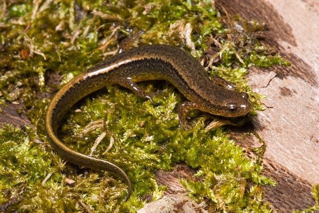
3    Recommendations for Aquatic Organism Passage at Maryland Road-Stream Crossings

    IMPORTANCE OF STREAM CONTINUITY FOR AQUATIC COMMUNITIES
    Access to spawning areas: Stream continuity is
    important for reproduction of migratory and
    resident fish species, alike. Both resident and
    diadromous fish species migrate to access
    spawning areas. Spawning runs range from short
    distances for resident species to hundreds of miles
    for some diadromous species. Stream continuity is
    crucial for anadromous and semi-anadromous fish
    species, which include striped bass, hickory shad,
    American shad, blueback herring and alewife
    (collectively known as river herring), white perch,
                                                            School of alewife during spawning run in Deer Creek,
    and yellow perch in the state of Maryland.              Maryland (Photo credit: Ryan Hagerty, USFWS)

    Access to coldwater habitats: Many aquatic
    species in Maryland, such as brook trout, rely on
    coldwater habitats as thermal refugia during warm
    summer months. These coldwater habitats include
    groundwater-fed, headwater streams that
    maintain cooler temperatures during the summer,
    as well as deeper pool habitats found along cool
    and coldwater streams. These thermal refugia are
    crucial for the survival and maintenance of
    coldwater aquatic communities – organisms that
    are excluded from coldwater habitats during             Brook trout, the only trout species native to Maryland,
                                                            have been deemed a “species of greatest conservation
    summer months due to movement barriers are
                                                            need” by MDNR. Brook trout are sensitive to poor water
    more susceptible to heat stress and mortality.          quality conditions and require access to coldwater habitats
                                                            for survival. (Photo credit: Ryan Hagerty, USFWS)

    Access to forage: Varied stream habitats have
    different prey communities and feeding
    opportunities depending on the location and time
    of year. For example, large predators, such as
    striped bass, will often travel to exploit schools of
    baitfish during certain seasons or time of day.
    Macroinvertebrate communities also vary along
    the stream network, presenting different feeding
    opportunities depending on location. When road
    crossings restrict movement, the fragmentation of
    streams can impede access to feeding areas and
                                                            Macroinvertebrate communities vary along stream
    impact fish communities.                                networks, providing different feeding opportunities for fish

                                                                                                           June 2021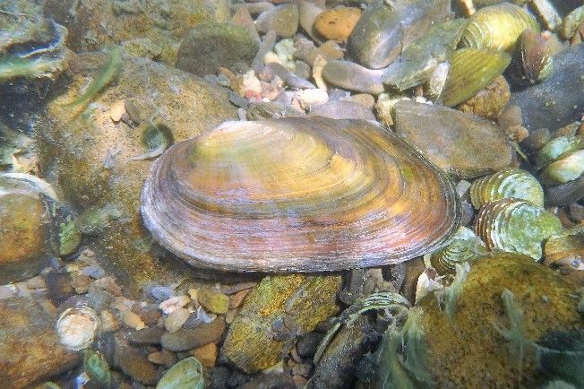
4    Recommendations for Aquatic Organism Passage at Maryland Road-Stream Crossings

    Natural dispersal: In addition to fish, other
    aquatic, semi-aquatic, and even terrestrial species
    rely on stream corridors for natural dispersal and
    re-colonization after disturbances (e.g., droughts,
    water quality contamination). Aquatic and semi-
    aquatic salamanders, frogs, and turtles utilize
    streams and streambanks for daily and seasonal
    movement. A barrier at a road-stream crossing
    may force these species to navigate over land and
    across roadways, exposing them to predators and
    roadway mortality. Unlike reptiles and
                                                           Adult northern two-lined salamanders are often found
    amphibians, which move freely on their own,            along stream margins, using streams and stream banks to
    freshwater mussel dispersal requires host fish         travel. (Photo credit: Kevin Stohlgren, Coastal Resources,
    species for dispersal. Mussels reproduce by            Inc.)
    releasing larvae, or glochidia, into the water. The    ryland (Photo credit: Ryan Hagerty, USFWS)
    glochidia attach to the fins or gills of host fish
    species and later release from the fish to colonize
    new stream reaches. Therefore, if a stream
    crossing blocks fish movement, then it also blocks
    upstream dispersal of freshwater mussels.

    Maintaining habitat: Culverts can create channel
    instability that degrades habitat, making
    conditions uninhabitable by native plants and
    animals. Undersized culverts can lead to upstream      Wood turtles utilize both aquatic and terrestrial habitats.
    and downstream bank erosion, resulting in wider        During mating season, stream blockages can be hazardous
    stream channels and increased fine sediment            to wood turtles by forcing them to navigate across
                                                           roadways. (Photo credit: Kevin Stohlgren, Coastal
    deposition that affect the quality of stream and
                                                           Resources, Inc.)
    riparian habitats.

    Genetic diversity: Populations require movement
    of individuals and habitat connectivity to maintain
    genetic diversity. Habitat fragmentation can result
    in unfavorable gene flow due to isolation and
    inbreeding within smaller groups of individuals.
    Road-stream blockages can isolate populations,
    which can lead to whole populations being
    eliminated, reduced, or genetically damaged.
    Maintaining genetic diversity is critical because it
                                                           Freshwater mussels require host fish species for
    allows populations to adapt to changing                distribution of their larvae throughout stream networks.
    environments.                                          Host species for this Eastern elliptio include American eel,
                                                           yellow perch, brook trout, and mottled sculpin.
                                                           ryland (Photo credit: Ryan Hagerty, USFWS)

                                                                                                          June 2021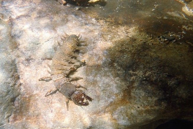
5 Recommendations for Aquatic Organism Passage at Maryland Road-Stream Crossings
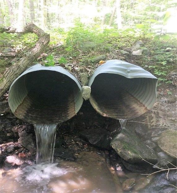
COMMON CULVERT PROBLEMS
Some causes of barriers to fish and other aquatic Open-bottomed structures and culverts
organisms can be traced back to the incorrect embedded below the streambed can allow for
sizing or installation of the structure. Site substrate and flows comparable to the
characteristics, such as downstream channel surrounding stream. Careful consideration should
degradation, steep channel slopes, sediment load, be given to the vertical and horizontal alignment of
and overall channel stability can also influence the crossing structure, relative to upstream and
whether a culvert becomes a barrier to aquatic downstream conditions.
organisms. Identifying and understanding
characteristics of poor stream crossings is critical
for evaluating whether a certain crossing should be
fixed or replaced and informs recommendations
for proper stream crossing design.
Undersized culverts can constrict channel flow
relative to the natural upstream and downstream
flow conditions, especially during flood events.
This can lead to sediment deposition, ponding,
flooding, clogging, and erosion. If undersized
crossings are left unchecked, they can result in
failed structures and damage to roadways or other
infrastructure. Undersized culverts create high
velocity through the structure during high flow
events. This high velocity can result in downstream Perched Culvert
scouring and sometimes perching. Resulting scour
pools downstream of undersized culverts can pose
an ongoing maintenance issue that needs to be
corrected with rip rap or other scour protection to
protect the structure. The scouring can create a
drop in water level below the outlet of the culvert
that results in a barrier to fish passage. Perched
culvert conditions can also result from long-term
bed degradation downstream of the culvert, or
steeper channel and structure slopes.
Structure installation, or placement, determines
the horizontal and vertical angle of the crossing
structure, relative to the stream channel. Shallow
crossings can result from structures that have been Shallow Crossing
installed too high, resulting in water depths that
are insufficient for aquatic organism passage.
Shallow crossing can also result from steep
channel and structure slopes or sediment
deposition in or upstream of the culvert.
June 2021
6   Recommendations for Aquatic Organism Passage at Maryland Road-Stream Crossings

    CONSEQUENCES OF POORLY DESIGNED STREAM CROSSINGS

            Vertical Barrier                      Low Flow                     Unnatural Bed Substrate

    Perched crossings can create an    Shallow crossings can be a           Smooth and uniform surfaces of
    impassable vertical barrier when   problem for fish and other           concrete and metal culverts
    an organism cannot overcome        organisms when water depths          provide no hiding and resting
    the difference in water surface    are insufficient for navigation      areas for aquatic organisms and
    elevation from within the          through the crossing structure.      are not ideal for organisms that
    structure to downstream during     Aquatic      organisms    need       travel along the streambed.
    typical flow conditions. Water     sufficient water depths to           Natural substrate, including
    depth below the outlet can also    navigate a structure under           rocks and finer sediments,
    dictate whether the vertical       typical flow conditions.             should      match       substrate
    barrier is passable for certain                                         characteristics      of       the
    species by providing a jumping                                          surrounding stream.
    pool.

          High Flow Velocity                       Clogging                     Scour and Bank Erosion

    When channel flows are             Undersized       crossings    and    Undersized       or    improperly
    constricted at a crossing, water   crossings consisting of multiple     aligned crossings can result in
    velocity can be substantially      cells can be prone to clogging by    bed scour and bank erosion due
    higher within the structure and    woody debris, leaves, trash, and     to high water velocities.
    out the outlet, compared to the    other      materials       carried   Excessive scour can create a
    surrounding stream. During         downstream. Debris jams at the       large scour pool and perched
    flood events, water velocities     upstream end of crossings can        outlet. Scour can also cause
    within undersized crossing         inhibit organism passage and         undermining of a culvert’s wing
    structures      can      prevent   can often lead to costly             walls and outlet apron resulting
    successful passage by fish and     maintenance to avoid flooding        in structural failure.
    other aquatic organisms.           or structure failure.

                                                                                                  June 2021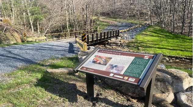
7    Recommendations for Aquatic Organism Passage at Maryland Road-Stream Crossings

    STREAM CROSSING RECOMMENDATIONS
    Below is a set of recommendations based on the       are meant to be used as minimum requirements
    geomorphic simulation design approach for road-      for maintaining stream continuity. Although
    stream crossings. Using a geomorphic simulation      descriptions of hydrologic site analysis are not
    approach allows for natural system processes         included here, due diligent site design to meet
    including flood resilience and aquatic organism      minimum cross-sectional area requirements
    passage. The recommendations below can assist        should be used. To complete a geomorphic
    designers in selecting stream crossing structures    assessment of the stream, existing conditions (e.g.,
    and placement that retain stream continuity and      bankfull width, gradient, water velocity, depth,
    protect stream health, as well as reduce             and substrate) upstream and downstream of the
    maintenance costs associated with erosion and        crossing should be measured. A section of the
    structural damage. This design approach allows       stream that is unimpacted by the crossing can be
    conditions within crossing structures to be          selected to represent characteristics that can be
    comparable to upstream and downstream                simulated within the crossing.
    conditions, with an emphasis on continuity of flow
                                                         Each section below includes an Objective as well as
    and substrate through the crossing and avoiding
                                                         two sets of recommendations: General or
    constriction of the channel and streambanks. Our
                                                         Preferred.     The     goal    of    the     general
    goal is to present recommendations for road-
                                                         recommendations is to provide overall stream
    stream crossings in Maryland that can be
                                                         continuity and passage for aquatic organisms and
    considered during the design process.
                                                         semi-aquatic and smaller terrestrial organisms.
    These recommendations were developed for             The preferred recommendations should be
    permanent road-stream crossings located along        considered for crossings where the stream
    non-tidal streams. They are intended for new and     corridor functions as a significant landscape-level
    replacement crossing structures, not repairs to      corridor and for crossings where terrestrial wildlife
    existing structures. Recommendations should be       passage is of particular concern. Preferred
    used to the maximum extent practicable given         recommendations include some numerical
    existing site and project constraints and are        descriptions intended solely as guidelines to clarify
    intended to provide conceptual guidance for          recommendations. The definitions section should
    passage of aquatic organisms and terrestrial         be referenced for further understanding of
    organisms under typical flow conditions. These       terminology used in the below recommendations.
    recommendations are not all-encompassing and

                            Characteristics of a Well-Designed Crossing

                                                                                                 June 2021
8    Recommendations for Aquatic Organism Passage at Maryland Road-Stream Crossings

    MARYLAND STREAM CROSSING RECOMMENDATIONS
    Note: see Design Considerations on pages 9, 10, and 11.

    1. Crossing Type                                             4. Location, Alignment, and Placement
    Objective: A single structure that allows the stream to      Objective: A structure that avoids unwanted
    pass through a single opening.                               aggradation and degradation inside or outside of the
    General: Spanning structures are recommended                 crossing due to unnatural slope or incorrect alignment.
    (bridges, bottomless arches, 3-sided box culverts, and       General: Culverts should be aligned with the natural
    other open-bottom culverts). One round, elliptical, or       stream channel and skew should be minimized.
    box culvert can be used where its dimensions can meet        Preferred: Culverts should be aligned with the natural
    the other recommendations (2-6) in this document. Use        stream channel and skew should be minimized, not
    of multiple culverts should be avoided. If the use of        exceeding 30 degrees. The gradient should not exceed
    multiple culverts is required, ensure that all flow passes   3% for buried/sunken culverts. If the gradient exceeds
    through one culvert during most flow conditions and          3%, a bottomless culvert or bridge should be used.
    other culverts are used only in high flow conditions.        When possible, crossing structures should be located at
    Preferred: Use a bridge.                                     a pool feature.

    2. Crossing Dimensions                                       5. Water Velocity and Depth
    Objective: A structure that spans the channel and banks      Objective: Maintain water velocity and depth, similar to
    to allow aquatic organism passage and dry passage for        conditions in the rest of the stream.
    most terrestrial species over a short distance.              General and Preferred: Water velocity and depth within
    General: The structure should be wide enough to              the crossing structure should match those observed at
    encompass a natural, stable channel and banks to allow       locations upstream or downstream, not impacted by
    not only aquatic, but also semi-aquatic and terrestrial      the crossing. Low flow conditions should not result in
    organism passage. To reduce length of passage for            reduced aquatic organism passage within the culvert,
    aquatic organisms, crossing length should be                 compared to upstream and downstream conditions.
    minimized, with the use of headwalls if necessary.
    Preferred: A structure that is wide enough to span a         6. Substrate
    natural, stable channel and banks (a minimum structure       Objective: Natural substrate through the road-stream
    width of 1.2 times the channel width) plus additional        crossing to provide habitat for aquatic and terrestrial
    headroom to provide semi-aquatic and terrestrial             species, similar to conditions upstream and
    wildlife passage. To achieve headroom for terrestrial        downstream of the crossing.
    species, the structure should have an openness ratio         General and Preferred: Substrate should be placed
    above the streambed, of 0.82 - 1.64 feet (0.25 - 0.5         within the structure, including both fine and coarse
    meters). Minimize crossing length with the use of            substrate, and should match the natural substrate
    headwalls if necessary.                                      composition found upstream or downstream in an area
                                                                 not impacted by the crossing. Bank and other key bed
    3. Embedment                                                 structural elements and characteristics should be
    Objective: Natural stream bottom through a crossing          resilient to high-flow events. If recommendations 1-5 of
    and stable footers for bottomless structures.                this document are used, natural aggradation and
    General: Per Maryland state regulations, culvert             degradation of substrate should not result in excessive
    bottoms should be embedded below the streambed a             scour within the crossing. Channel manipulation
    minimum of 1 foot. Footers of bottomless structures          upstream and downstream of the structure (e.g.,
    should be placed at a depth and width to avoid               stream restoration, stabilization, etc.) may be needed to
    destabilization through scour.                               fill scour holes and reduce aggradation caused by
    Preferred: If a bridge is not feasible due to project        previous road-stream crossing structures. Scour
    constraints, culvert bottoms and footers for bottomless      protection should not result in reduced aquatic
    structures should extend below the vertical adjustment       organism passage.
    potential.

                                                                                                            June 2021
9 Recommendations for Aquatic Organism Passage at Maryland Road-Stream Crossings
DESIGN CONSIDERATIONS
The primary purpose of the recommendations Aquatic Organisms at Road-Stream Crossings”,
presented in this document is to prevent barrier included under Additional Resources.
effects of road-stream crossings on fish and other
Structure Width: A structure width of 1.2 times the
aquatic organisms. With that in mind, these
channel width is intended to be the minimum
recommendations were developed to promote
recommended width for maintaining channel and
designing crossings that are nearly “invisible” to
bank stability during frequent storm events (e.g.,
aquatic organisms by maintaining stream
about 1.5-year storms); however, this should be
continuity. These recommendations may not be
verified based on site characteristics. The
sufficient for all project needs, including
minimum structure width may be inadequate for
addressing drainage or flooding issues. Project and
maintaining bank and other key bed elements
site constraints must also be considered during the
within the crossing structure during higher flows
design and permitting of new and replacement
associated with infrequent storm events. Wider
stream crossings. For example, effects of
structures or the use of multiple culverts to convey
downstream flooding resulting from increasing the
flood waters may be necessary to avoid excessive
size of a culvert needs to be considered.
flow constriction and washout of bed materials
These stream crossing recommendations are not during high flow events. Channel width should be
prescriptive, and the use of these determined from a minimum of three
recommendations does not replace the need for measurements. For new crossings, channel width
sound engineering and design practices completed should be measured at the proposed crossing
by qualified professionals. The design approach for location, as well as upstream and downstream of
a road-stream crossing should be dictated by the proposed location. For replacement crossings,
project objectives and site/project constraints. channel width should be determined along straight
Common design approaches for providing aquatic sections of the stream, outside the influence of the
organism passage, such as geomorphic simulation, existing crossing or other structures. Determining
hydraulic simulation, and hydraulic design, all channel width and the appropriate structure size
require an understanding of project needs, stream can be particularly difficult in degraded or urban
geomorphology, and hydrology. The streams. The minimum structure width of 1.2
recommendations presented here are most times the channel width is typically recommended
consistent with the geomorphic simulation, or under the assumption that bankfull width is used
“Stream Simulation”, design approach. Crossings as the channel width (e.g., “Massachusetts Stream
designed with this approach have a continuous Crossings Handbook”). A calculated bankfull width
bed that approximates the natural streambed up using regional curve data can be used to verify field
to bankfull flows. The “Stream Simulation” calculations (See Additional Resources).
approach avoids constriction of the channel and Alternative channel width measurements can also
banks and creates a stream channel with a diverse be used to determine structure width, such as
streambed throughout the crossing, reflective of active channel width; however, different
conditions along the adjacent stream. For multipliers, such as 1.5 times the active channel
additional details, please refer to the U.S. Forest width are typically used (e.g., National Marine
Service publication “Stream Simulation: An Fisheries Service “Guidelines for Salmonid Passage
Ecological Approach to Providing Passage for at Stream Crossings”) to meet the objectives of this
recommendation.
June 202110 Recommendations for Aquatic Organism Passage at Maryland Road-Stream Crossings
Openness: There is limited information on how fish channel and bed characteristics through natural
and wildlife utilize culverts in response to different bed load transport. In order to ensure bed stability
openness ratios; however, confinement is at higher flows, it may be necessary to use larger
generally thought to lead to avoidance. Studies on substrate within the structure than is found
structure usage and avoidance by large mammals upstream or downstream, depending on site
have found that minimum openness ratios for characteristics.
passage range from about 1.5 feet to over 3 feet.
Predicted channel evolution upstream and
The goal of the minimum openness ratio
downstream of the crossing should also be
recommendation of 0.82 feet is to maintain an
considered, as well as the potential for upstream
openness ratio that is sufficient for fish and small
bed degradation resulting from the use of an
riverine wildlife species. Structures that meet this
embedded structure.
openness ratio are also more likely than traditional
culverts to pass flow and debris that could
otherwise obstruct water passage. The intent of Common Stream Crossing
the maximum openness ratio of 1.64 feet is to
Measurements
provide additional connectivity along the stream
corridor for terrestrial species. This ratio, with a
structure clearance of at least 6 feet, has been
used by other states to provide some passage for
larger mammals.
Embedment and Substrate: The minimum
embedment recommendations may not be Stream width
sufficient for all culverts. Ideally, culvert bottoms
and footers should be placed below the elevation
of the vertical adjustment potential and should
account for long-term bed degradation. Stream
conditions may dictate the need for greater
embedment, such as in higher gradient streams or
less-stable systems. Scour protection measures
can also be considered, depending on the
magnitude of predicted vertical adjustment
potential and long-term bed degradation;
however, protection measures should not result in Crossing width and cross-sectional area
reduced aquatic organism passage. Substrate
within the structure should be similar to the
characteristics of the substrate in the natural
stream channel upstream and downstream of the
crossing. Design considerations should be made to
ensure that substrate within the structure meets
the desired characteristics after a period of
adjustment following construction. Substrate
characteristics should be designed for resiliency, to
resist the complete loss of bed material during
Crossing length
large storms events and to maintain appropriate
June 202111 Recommendations for Aquatic Organism Passage at Maryland Road-Stream Crossings
Location, Alignment, and Placement: Structure Regulations: The stream crossing
design should consider the channel type and recommendations presented in this document are
longitudinal profile of the stream. The longitudinal not regulations. These recommendations are
profile should provide enough information to intended to be used in conjunction with local,
determine the vertical alignment of the stream state, and/or federal regulations, including those
through the crossing (e.g., concave, convex, found in Code of Maryland (COMAR) Sec.
uninform slope, etc.) and the survey should ideally 26.17.04.06. Bridges and Culverts, Maryland State
extend 20-30 times the bankfull width on both the Programmatic General Permit (SPGP), and
upstream and downstream ends of the crossing. Regional Conditions to the 2020 Nationwide
Structure location and alignment should include Permits (NWP) for the State of Maryland. Under
considerations outside of the footprint of the COMAR Sec. 26.17.04.06, culverts “shall have at
structure in order to account for the stream’s least one cell placed at least 1 foot below the invert
existing geomorphology and predicted channel of the stream” and “protective measures may not
evolution upstream and downstream of the prevent the passage of fish.” Under the SPGP-5,
channel. In some situations, channel manipulation activities within Waters of the U.S. “must not block
upstream and downstream of the crossing (e.g., or impeded the movements of anadromous or
stream restoration, stabilization, etc.) may be resident fish species.” The SPGP and NWP
required to maintain stability of the structure and guidelines also require depressing culvert bottoms
channel. On some occasions, a crossing may need and considering the use of bridges or bottomless
to maintain a slope different than the natural crossing structures. See Additional Resources for
stream channel. For example, an existing structure resources on state and federal regulations.
may be acting as a grade control due to an incised
downstream channel. This needs to be considered
early in the planning and design process for
replacement structures to determine the best
design alternatives for maintaining aquatic
organism passage.
Example of a longitudinal profile, showing basic measurements often used by engineers in stream-crossing design. An
example of vertical adjustment potential (VAP) is also depicted, showing the range of potential vertical streambed
adjustment.
June 202112 Recommendations for Aquatic Organism Passage at Maryland Road-Stream Crossings
ADDITIONAL CONSIDERATIONS
Although not specifically addressed by Undersized crossings are more vulnerable to
recommendations in this document, future overtopping and can be more susceptible to failure
changes to the watershed, such as planned during high flow events. Future planning that
development, and changes in storm frequency and considers this overlap between ecological and
intensity associated with climate change should be transportation goals by promoting flood resiliency
considered when determining structure size and and stream continuity can benefit the
alignment, to the extent feasible. Engineers communities utilizing both the road and the
typically use historic data to predict the stream. Additional details on the financial benefits
magnitude, seasonality, and duration of low flows of maintaining aquatic continuity through flood-
critical to aquatic organism passage, and to resilient crossings are provided in the following
characterize storm event patterns in order to section.
design resilient crossings based on the probability
of similar storm events occurring in the future. Past
practice has assumed that the magnitudes and
temporal patterns of future flows will match those
that occurred in the past. However, observations
show that these patterns are changing, and models
predict that they will continue to change within the
design life of structures. Instead of relying solely on
historical data, climate models and assessments
should be considered during the design process to
Flooded roadway along MD 450 due to undersized and
account for predicted changes in hydroclimate,
clogged culverts (Photo credit: Capital Gazette)
including alterations in seasonal precipitation, the
duration of dry periods, and the timing and
distribution of precipitation events. See Additional
Resources for climate change resources.
Crossing structures designed and installed in other
states that followed similar recommendations
presented in this document have been found to
safely pass large volumes of water, sediment, and
debris stirred up by high flows, while maintaining
safe travel for the public. This is important with
respect to climate change, because predicted
changes in storm frequency and intensity will likely
result in more frequent large-flow events. Because
common causes of movement barriers for aquatic
organisms can often be traced back to undersized
structures (e.g., perched outlets, scour pools, and Undersized culverts can become a barrier to aquatic
debris jams), goals for aquatic organism passage organism movement long before they become an
issue for public safety and infrastructure. (Photo
and infrastructure resiliency can often align by
credit: Seth Moessinger, Trout Unlimited)
maintaining or restoring stream continuity.
June 202113 Recommendations for Aquatic Organism Passage at Maryland Road-Stream Crossings
FINANCIAL BENEFITS OF MAINTAINING STREAM CONTINUITY
Financial considerations in the planning and design spans the banks and is capable of passing higher
process should account for long-term benefits and flows can be lower over its lifetime than an
not solely the short-term costs of replacing or undersized crossing structure. Stream simulation
installing a structure. This includes considering the designs that span the bankfull channel can have
economic, societal, and natural resources costs of little or no annual maintenance costs and are
a potential crossing failure, including effects on resilient to flooding, whereas hydraulic designs
adjacent infrastructure and private property. In that constrict the stream channel can require
addition, delay costs and risks to public health and frequent maintenance for debris removal and can
safety from the disruption of commerce and travel pose a greater risk of failure during large floods.
due to a failed structure and collapsed roadway Further, bottomless or properly embedded
should be considered, despite the difficulty in structures that span the channel can be protected
quantifying such costs. from bedload abrasion by the constructed stream
channel bed and margins. Galvanized steel culverts
During storm events, crossing structures may fail
installed using stream simulation design methods
when flows exceed the hydraulic capacity of the
can have an expected service life of 50 to 75 years,
structure and/or sediment and debris clog the
compared to 25 to 50 years for a traditional
structure, which can result in severe and costly
galvanized steel culvert installed with hydraulic
impacts to human safety, property, and
design methods. Following large storm events,
infrastructure. The likelihood of a culvert failing
adjustments to streambed construction can
during a flood event can be reduced through
sometimes be necessary for structures designed
appropriate sizing and configuration, especially
using stream simulation methods; therefore,
when those culverts are replaced with a bridge or
maintenance costs are not always negligible and
appropriately designed culvert. Emergency
case studies in Maryland are needed to assess the
structure replacement costs following an
performance structures designed using “Stream
unexpected structure failure are generally higher
Simulation” methods.
than planned replacement costs.
Additional information on financial benefits and
Utilizing a design approach that provides better
economic analyses of improved road-stream
ecological connectivity and flood resiliency over
crossings can be found in the References section.
traditional hydraulic design practices focused on
flood capacity can appear less economical due to
higher upfront installation costs. For example, data
from culvert replacements in the northwestern
United States indicates that increasing the width of
a crossing structure by 50 percent can result in an
increase in installation costs by 20 to 33 percent.
These replacement costs also depend on stream
size, as the cost of removing barriers at culverts
typically increases with stream size.
When maintenance, replacement, and longevity
are considered in overall cost, however, the Collapsed roadway in Ellicott City, MD due to flooding
average annual cost of a stream crossing that (Photo credit: Katherine Frey, The Washington Post)
June 202114 Recommendations for Aquatic Organism Passage at Maryland Road-Stream Crossings
CASE STUDY: WOLFDEN RUN CULVERT REPLACEMENT
Wolfden Run is a tributary to the Potomac River, Trout Unlimited served as the project manager and
located in Garrett County, Maryland. The received funding from the USFWS’s National Fish
surrounding land was acquired by the Maryland Passage Program and National Fish Habitat
Department of Natural Resources (DNR) and has Partnership through the Eastern Brook Trout Joint
been incorporated into the Maryland State Park Venture.
system. The road-stream crossing at Wolfden Run
The project removed the barrier for migrating fish,
was prioritized by Trout Unlimited because the
reconnecting brook trout to 2.8 miles of
stream is inhabited by brook trout. Due to the
headwater habitat and provided a stable span
presence of multiple culverts and poor condition of
bridge sufficient for conveying emergency vehicles
the crossing, fish passage was severely limited. In
into the park. The bridge will improve recreational
addition, the existing road did not meet standards
opportunities within Wolfden Run State Park,
required for emergency vehicles to access the now
allowing visitors to have better access for fishing,
state-owned property. Maryland DNR, Trout
bird watching, hiking, and other outdoor
Unlimited, and USFWS partnered to replace the
recreational activities.
road-stream crossing with a goal of providing fish
passage and stream continuity. Maryland DNR
completed the survey and design work for the
project with guidance from USFWS.
Original multiple pipe culvert (Photo credit: Seth Replacement span bridge (Photo credit: Seth Moessinger,
Moessinger, Trout Unlimited) Trout Unlimited)
Location: Kitzmiller, MD
Project Partners: Maryland DNR, Trout
Unlimited, USFWS, Eastern Brook Trout
Joint Venture, National Fish and
Wildlife Foundation
Project Cost: $156,000
Replacement span bridge and educational plaque (Photo Estimated 2021 Cost: $161,602
credit: Seth Moessinger, Trout Unlimited)
June 202115 Recommendations for Aquatic Organism Passage at Maryland Road-Stream Crossings
CASE STUDY: BOBBS CREEK AQUATIC ORGANISM PASSAGE PROJECT
Bobbs Creek is a high quality coldwater tributary to two 48 in. x 26 ft. corrugated metal pipes and
Tionesta Creek, located in the Allegheny National crossing 116/2 was comprised of three 48 in. x 34
Forest (ANF) in Forest County, Pennsylvania. Trout ft. corrugated metal pipes.
streams within the ANF are considered a priority
In the summer of 2011, both crossings were
for brook trout conservations due to existing brook
replaced with bottomless galvanized steel box
trout populations and its proximity to the western
culverts, set on concrete footers and filled with
extent of the current range for eastern brook
natural gravel substrate. The new structures span
trout.
the bankfull width of the streams, restoring
Within the ANF, US Forest Service (USFS) Road 116 aquatic organism passage to 3.8 miles of habitat.
parallels Bobbs Creek for over a mile and a half, Additional project goals included re-establishing
crossing two unnamed tributaries. These two natural stream processes and habitat conditions;
crossings (hereafter crossings 116/1 and 116/2) improving recreational fisheries; reducing flooding
were acting as fish barriers, becoming choked with potential of USFS road 116; and reducing sediment
debris and creating conditions that were delivery downstream to Bobbs Creek. With an
impassable for brook trout during much of the expected lifespan of at least 50 years for the
year. In addition, these crossings also had a high replacement culverts, this project is expected to
potential for failure, safety concerns, and the have long-term benefits to the watershed, as well
potential to deliver large sediment loads to Bobbs as providing improved flood resilience for USFS
Creek. Both crossings were comprised of multiple Road 116 at these crossings.
pipe culverts – crossing 116/1 was comprised of
Original triple pipe culvert at USFS Road 116/2 (Photo Replacement bottomless culvert at USFS Road 116/2
credit: Brent Pence, USFS) (Photo credit: unknown, USFS)
Location: Forest County, PA
Project Partners: USFWS, Eastern
Brook Trout Joint Venture, and
Allegheny National Forest (USFS)
Project Cost: $93,000 per crossing
Estimated 2021 Cost: $110,029
Replacement bottomless culvert at USFS Road 116/2
June 202116 Recommendations for Aquatic Organism Passage at Maryland Road-Stream Crossings
CASE STUDY: FISH KILL CREEK CULVERT REPLACEMENT
Working with the USFWS, the Town of Newfield Douglas Road was replaced by a bottomless
(New York) replaced a failing culvert along Douglas aluminum box culvert, designed by Contech
Road, located at the Fish Kill Creek crossing. Engineering Solutions. During installation, the old
Because of an overlap between conservation culvert was removed and concrete foundations
priorities and the need to repair the failing culvert, were formed and poured. The streambed below
technical and funding support was available to the the culvert was armored with coarse stone and
Town of Newfield. During the planning process, then backfilled after the culvert was set in place.
the Town of Newfield considered replacing the The replacement culvert was 16 ft. and 4 in. wide,
structure with a bridge; however, that option with a rise of 5 ft. and 11 in and a total length of 49
would have required Tompkins County to take ft. and 9 in. The minimum culvert width
ownership and maintenance of the structure requirement for New York (1.25 times the width of
which would have resulted in project delays. Due the stream channel bed) could not be attained due
to safety concerns with the existing culvert rusting to site constraints; however, the larger structure
and joints becoming separated, a bottomless width improved existing conditions by more
culvert option was selected to avoid delays and closely reflecting the upstream ordinary high water
funding issues. width. In addition, the open bottom allowed for
natural substrate to fill in, improving aquatic
In 2016, the original 10 ft. diameter steel pipe that
organism passage.
was conveying Fish Kill Creek underneath of
Original steel pipe culvert at Douglas Road (Photo Replacement bottomless culvert at Douglas Road
credit: unknown, T.G. Miller, P.C.) (Photo credit: Betsy Trometer, USFWS)
Location: Newfield, NY
Project Partners: USFWS, Town of
Newfield
Project Cost: $129,620
Estimated 2021 Cost: $143,622
Replacement bottomless culvert at Douglas Road
June 202117 Recommendations for Aquatic Organism Passage at Maryland Road-Stream Crossings
CASE STUDY: RUTLAND ROAD FISH PASSAGE PROJECT
The North River flows into the tidal South River and The structure replacement also involved stabilizing
eventually out to the Chesapeake Bay. Historically, the North River streambed approximately 350 feet
the North and South Rivers supported spawning between Rutland Road and a large, open-water
runs for a variety of migratory fish species, wetland complex upstream. This project presented
including yellow perch. The lower extent of the non-traditional design constraints, as the open-
North River parallels MD Route 450, or Defense water wetland complex upstream had to be
Highway. The North River flows under Rutland maintained. To overcome this constraint, weir wall
Road, near its intersection with MD Route 450. structures were utilized upstream of the bridge
and rock ramps were utilized downstream of the
The pre-existing structure located at the Rutland
bridge to maintain the open-water habitat and
Road crossing was a triple-cell culvert consisting of
aquatic organism passage.
48 in. corrugated metal pipes. This triple-cell
culvert was failing structurally, contributing to The project successfully removed the physical
flooding of Rutland Road and MD Route 450, and barrier to migrating fish that was created by the
was acting as a blockage to migrating fish. In 2018, old triple-cell culvert, providing access to
the Anne Arundel County Bureau of Watershed approximately six miles of upstream habitat for
Protection and Restoration (BWPR) replaced the yellow perch and other species. Preliminary
failing culverts with a pre-stressed concrete slab reports also indicate that the project may have
bridge that spans the channel. helped with roadway flooding issues, as MD Route
450 remained open during most heavy rain events
following the completion of the project.
Original triple pipe culvert at Rutland Road Replacement slab bridge at Rutland Road
Location: Davidsonville, MD
Project Partners: Anne Arundel
County BWPR; County Engineers
Association of Maryland
Project Cost: $1,850,000
Estimated 2021 Cost: $1,960,600
Weir wall structures installed upstream of roadway
June 202118 Recommendations for Aquatic Organism Passage at Maryland Road-Stream Crossings
PRIORITIZING EFFORTS FOR TARGET SPECIES
Although stream continuity benefits aquatic
communities as whole, the Chesapeake Bay
Program’s Fish Passage Workgroup has worked to
develop criteria for prioritizing fish passage
projects in the Chesapeake Bay region. Specific
target fish species for conservation efforts in
Maryland include diadromous species (American
eel, alewife, blueback herring, American shad,
and hickory shad), brook trout, and rare, American eel (Photo credit: Kevin Stohlgren,
threatened, and endangered species. Through Coastal Resources, Inc.)
collaborative efforts, the Fish Passage Workgroup
The North Atlantic Aquatic Connectivity
and The Nature Conservancy (TNC) developed the
Collaborative (NAACC) also has valuable resources
Chesapeake Fish Passage Prioritization Tool
for documenting and assessing the severity of
(https://maps.freshwaternetwork.org/chesapeak
blockages at road-stream crossing as well as
e/), which uses GIS data to rank potential barrier
prioritizing conservation efforts. The NAACC
removal projects throughout the Chesapeake Bay
houses an online database
watershed. This online tool houses GIS data and
(https://naacc.org/naacc_search_crossing.cfm)
metrics on hundreds of documented fish
where road-stream crossing assessment data are
blockages in the region and rankings can be
stored. The distribution of available road-stream
customized to meet different needs. Potential fish
crossing assessment data in Maryland is based on
passage projects with the following
U.S. Fish and Wildlife Service’s priority species
characteristics were deemed high priorities for
including anadromous fish, brook trout, federally
removal by the Fish Passage Workgroup: barrier
listed species, and at-risk species. The NAACC
to migratory fish; benefits to multiple species;
website also houses additional information about
largest habitat gains; high quality habitat; barrier
road-stream crossings such as prioritizations and
to brook trout.
protocols for assessing road-stream crossings.
Other states have developed prioritization models
to rate aquatic connectedness and inform stream-
crossing design practices. For example, the
University of Massachusetts developed Critical
Linkages to assess connectivity and restoration
potential for barrier removal projects. The
University of Massachusetts also developed the
Conservation Assessment and Prioritization
System (CAPS) to assess the ecological integrity for
various ecological communities, including streams.
Resource information for Critical Linkages, CAPS,
the Chesapeake Fish Passage Prioritization Tool,
Chesapeake Fish Passage Prioritization Tool (Obtained from and the NAACC database can be found in the
https://maps.freshwaternetwork.org/chesapeake) Additional Resources section.
June 202119 Recommendations for Aquatic Organism Passage at Maryland Road-Stream Crossings
DEFINITIONS
Active channel width: The width between the ordinary high water lines of the channel measured
perpendicular to streamflow. The active channel width is typically narrower than the bankfull width.
Ordinary high water lines are typically determined by changes in bank vegetation; changes in sediment
size and/or color; water lines on the bank, trees, or leaves; or the point where debris accumulation begins.
Anadromous: Fish born in freshwater that spend most of their lives in saltwater and return to freshwater
to reproduce, or spawn.
Bankfull width: The width of the water surface elevation at bankfull discharge, measured perpendicular
to streamflow.
Diadromous: Fish that spend part of their life cycle in freshwater and part of their life cycle in saltwater.
Embedded: Also referred to as sunken, countersunk, or depressed, with respect to culverts. Embedded
culverts are placed with their bottom below the streambed elevation to allow for natural substrate along
the bottom.
Geomorphic simulation: Design approach that attempts to maintain or recreate natural stream reach
geomorphic elements through the crossing, including slope, channel width, substrate, and bedform.
Hydraulic design: Design approach that utilizes natural or artificial flow control structures to create
hydraulic conditions (e.g., water depth and velocity) that meet the swimming abilities of target fish species
during specific periods of fish movement or migration.
Hydraulic simulation: Design approach that attempts to closely match streamflow characteristics in the
crossing structure to that of the natural stream. Common techniques include embedding culvert
structures, avoiding most channel constriction, and using natural and coarse sediment in the structure.
This approach assumes that providing hydraulic diversity that is similar to that found in the natural stream
will allow for aquatic organism passage.
Long-term bed degradation: The vertical change in the channel profile other than that caused by local or
contraction scour.
Longitudinal profile: A longitudinal profile is a surveyed profile along the deepest portion of the stream
channel. This plot of elevation over distance along the channel is used to characterize the stream slope
and depths of various channel features.
Openness ratio: Defined as the cross-sectional area of a structure’s opening divided by the crossing
length, when measured in consistent units (e.g., feet, meters, etc.). The embedded portion of a culvert is
not included in the cross-sectional area for determining openness.
Perching: The tendency to develop a scour hole at the outfall of a culvert due to erosion of the stream
channel.
Semi-anadromous: Fish that occupy intermediate life history characteristics between resident and
anadromous fish. They feed in brackish waters at the mouths of rivers and estuaries and reproduce in
freshwater without fully migrating to saltwater habitats.
June 202120 Recommendations for Aquatic Organism Passage at Maryland Road-Stream Crossings
Stream continuity: The uninterrupted connection of a river network where the natural physical
characteristics of the stream have not been significantly altered and few or no barriers exist that would
hinder or block movement up and downstream through the system by aquatic organisms.
Thermal refugia: A place that serves as shelter from adverse temperatures.
Vertical adjustment potential: The range of elevations over which the streambed might vary over the life
of a structure. A longitudinal profile is necessary to determine the vertical adjustment potential of the
streambed.
June 2021You can also read