Release Guide ERDAS IMAGINE 2022 - Hexagon AB
←
→
Page content transcription
If your browser does not render page correctly, please read the page content below
Release Guide

Release Guide
ERDAS IMAGINE 2022

Version 16.7.0

21 October 2021
ERDAS IMAGINE 2022

Contents
About This Release ................................................................................................................... 5

ERDAS IMAGINE Product Tiers ............................................................................................... 5

New Platforms ........................................................................................................................... 6
   Windows 11 Support ................................................................................................................ 6
   Licensing ................................................................................................................................. 6

New Technology........................................................................................................................ 7
   Image Chain as the Default Raster Display Mode ................................................................... 7
   Windows Scaling Support ........................................................................................................ 9
   Automated GCP Creation and Image Coregistration in Spatial Modeler Photogrammetry
   Workflows .............................................................................................................................. 13
   New Spatial Modeler Operators ............................................................................................. 15
      Add Control Points to Block ................................................................................................ 15
      Attribute Statistics............................................................................................................... 15
      Calculate Flow Concentration............................................................................................. 15
      Calculate Processing Quantity ........................................................................................... 16
      Classify Features................................................................................................................ 16
      Convolve Fuzzy Classifications .......................................................................................... 16
      Define Control Points ......................................................................................................... 17
      Define Block Parameters For Mixed Sensor Model ............................................................ 17
      Define Continuity Model Parameters .................................................................................. 18
      Define Focal Parameters .................................................................................................... 18
      Generate Control Points Based On Reference ................................................................... 18
      Generate Deep Learning Training Chips ............................................................................ 19
      Generate Stereo Pairs ........................................................................................................ 19
      Generate Topology Features.............................................................................................. 19
      Get Dictionary Names ........................................................................................................ 20
      Get Iterator Execution Method Resources .......................................................................... 20
      Interpolate Using Kriging .................................................................................................... 20
      Read Digital Camera Parameters From ORIMA File .......................................................... 21
      Read Frame Camera Parameters From ORIMA File .......................................................... 21
      Read Image Parameters For Mixed Sensor Model ............................................................. 21

21 October 2021                                                                                                                               2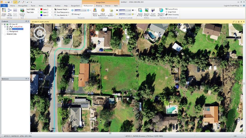
ERDAS IMAGINE 2022

 Updated Spatial Modeler Operators ...................................................................................... 22
    Associate Georeference ..................................................................................................... 22
    Cell Area/Cell X/Cell Y/Orthorectify .................................................................................... 22
    Compute Transform ........................................................................................................... 22
    Convert .............................................................................................................................. 23
    Convert to Features............................................................................................................ 23
    Convert to Raster ............................................................................................................... 25
    Create SGM Point Cloud .................................................................................................... 26
    Custom Matrix Input ........................................................................................................... 27
    Define Adjustment Options For Orbital Pushbroom Model ................................................. 28
    Define Image Parameters For Rational Function Model ..................................................... 28
    Define Mosaic Input Options .............................................................................................. 29
    Define Point Match Options ................................................................................................ 29
    Dictionary Item ................................................................................................................... 30
    GeoPackage, File Geodatabase, and CSV support in Features Input and Features Output
    ........................................................................................................................................... 30
    Get JPEG 2000 Options ..................................................................................................... 31
 Spatial Model Editor Interface Improvements ........................................................................ 31
    Reorganized Spatial Modeler Ribbon Tab .......................................................................... 31
    Search a Model For An Operator ....................................................................................... 31
    The Mouse Cursor Reflects if a GUI is Available ................................................................ 32
    Open Non-spatial Model/Operator Outputs in a Dialog ...................................................... 32
    Connect Two Widely Separated Operator Ports ................................................................. 32
    Align Operators Functions .................................................................................................. 33
    Save As to Python script .................................................................................................... 36
    Center Dialogs on Same Screen as Spatial Model Editor................................................... 36
 Format Support ...................................................................................................................... 37
    Landsat 4, 5, 7, and 8 from USGS ..................................................................................... 37
    JPEG 2000 NoData Mask .................................................................................................. 37
    DIMAP v2 ........................................................................................................................... 37
    SRTM HGT ........................................................................................................................ 37
    Esri File Geodatabase ........................................................................................................ 37
    SIDD 1.1............................................................................................................................. 37
    NITF ................................................................................................................................... 37

21 October 2021                                                                                                                                 3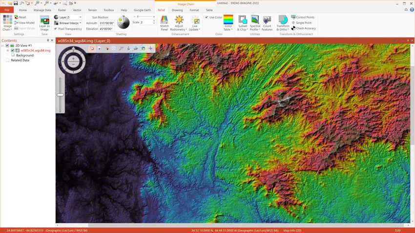
ERDAS IMAGINE 2022

      Features from S3 Bucket .................................................................................................... 37
   General ERDAS IMAGINE..................................................................................................... 38
      SIPS v2.4.16 ...................................................................................................................... 38
      Inquire Box Improvements ................................................................................................. 38
      Filename Case Retention ................................................................................................... 38
      File Chooser Improvements ............................................................................................... 39
      GPU Acceleration ............................................................................................................... 40
      Projected Coordinate Systems (PCS) ................................................................................ 40
      MosaicPro .......................................................................................................................... 40
   SAR Functionality .................................................................................................................. 41
      Beta 0 ................................................................................................................................. 41
      Sigma 0 .............................................................................................................................. 41
      E-Z Coherence Change ..................................................................................................... 41
      Sentinel-1 GRD .................................................................................................................. 41
      Sentinel-1 Image Formation ............................................................................................... 41
      Capella ............................................................................................................................... 41
      ICEYE ................................................................................................................................ 41
      COSMO SkyMed Second Generation (CSG) ..................................................................... 41

System Requirements ............................................................................................................ 42
   ERDAS IMAGINE .................................................................................................................. 42
   ERDAS IMAGINE System Requirements Notes .................................................................... 43

Issues Resolved – ERDAS IMAGINE 2022 ............................................................................ 44
   IMAGINE Essentials .............................................................................................................. 44
   IMAGINE Advantage ............................................................................................................. 45
   IMAGINE Objective................................................................................................................ 46
   IMAGINE Photogrammetry .................................................................................................... 47
   IMAGINE Professional ........................................................................................................... 48
   Spatial Modeler ...................................................................................................................... 49
   ERDAS ER Mapper ............................................................................................................... 50

Contact Us ............................................................................................................................... 51

About Hexagon........................................................................................................................ 51

21 October 2021                                                                                                                                4
ERDAS IMAGINE 2022

About This Release
This document describes enhancements in ERDAS IMAGINE 2022 (v16.7.0), including IMAGINE
Photogrammetry (formerly LPS Core) and ERDAS ER Mapper.

ERDAS IMAGINE 2022 includes both enhancements and fixes. For information on fixes that were made to
ERDAS IMAGINE, see the Issues Resolved section.

This document is only an overview and does not provide all the details about the product's capabilities. See
the product description, the online help and other documents provided with ERDAS IMAGINE for more
information.

ERDAS IMAGINE 2022 is not available as a 32-bit version. Consequently, only two separate installers are
provided: ERDAS IMAGINE 2022 64-bit and ERDAS ER Mapper 2022.

ERDAS IMAGINE Product Tiers
ERDAS IMAGINE performs advanced remote sensing analysis and spatial modelling to create added
information. You can also visualize results in 2D, 3D, or video and on cartographic-quality map compositions.
The core of the ERDAS IMAGINE product suite is scalable to your geospatial data. Optional modules (add-
ons) provide specialized functions to enhance productivity.

IMAGINE Essentials is the entry-level image processing product for map creation and simple feature collection
tools. IMAGINE Essentials enables serial batch processing.

IMAGINE Advantage enables advanced spectral processing, image registration, mosaicking and image
analysis, and change detection capabilities. IMAGINE Advantage allows you to process parallel batches for
faster output.

IMAGINE Professional includes a production toolset for spatial modeling and advanced spectral,
hyperspectral, and radar processing.

IMAGINE Photogrammetry maximizes productivity with state-of-the-art photogrammetric satellite and aerial
image processing algorithms.

21 October 2021                                                                                                 5
ERDAS IMAGINE 2022

New Platforms
Windows 11 Support
At the time of producing the final release candidate for ERDAS IMAGINE 2022, Microsoft Windows 11 had not
been officially released to the public. However, ERDAS IMAGINE 2022 was tested using pre-release versions
(21H2 Build 22000.65, 22458.1000 and 22471.1000) via the Windows Insider Program, and all issues found
were addressed. It is therefore expected that ERDAS IMAGINE 2022 will work with the release version of
Windows 11. An official announcement will be made regarding the support status of Windows 11 once the
release version has been fully tested.

Licensing
ERDAS IMAGINE 2022 installers no longer attempt to automatically install geospatial licensing tools as part of
the installer. If you wish to use geospatial licensing tools — for example, to set up a floating/concurrent license
server — you must download Geospatial Licensing 2022 separately.

We strongly recommend upgrading to the newest version of Geospatial Licensing 2022. If you are unsure of
your current version, refer to the Microsoft Windows Add or Remove Programs utility.

You can find the appropriate download in the Downloads section of the Hexagon Geospatial website.

21 October 2021                                                                                                  6
ERDAS IMAGINE 2022

New Technology
Image Chain as the Default Raster Display Mode
Image Chains are standardized models for displaying imagery via a series of linked processing steps (the
chain) whose parameters are set initially by information derived from the specific file being displayed, but
which can be adjusted by the user.

For example, a single band athematic image that is identified as being elevation data may display in a very
different fashion than one identified as panchromatic data in the visible spectrum wavelength. The former
would display using a sun-angle shaded relief rendering, while the latter would display with a more traditional
DN to screen brightness stretch. Similarly, a WorldView-2 image might trigger the selection of a different set of
statistical stretch and filter parameters than those used for a Pleiades image. This provides for data-specific
default display styling.

For several releases now, Image Chains have been provided as an alternative to the traditional Raster mode
of displaying imagery. With the release of ERDAS IMAGINE 2022, the Image Chain has been switched to be
the default behavior. Consequently, if a raster file is dragged into a 2D View or is selected using the File
Chooser without changing any settings in the dialog, the data will default to being displayed via the appropriate
Image Chain.

Some users may still prefer to use the older Raster mode of rendering by default, and this can be switched
through the Preference Editor (or via an option on the File Chooser that sets the Preference directly). In the
Preference Editor, select the Viewing category and then the Viewer sub-category. Change the Default Raster
Rendering Engine preference from Image Chain to Legacy and save the change if you wish to use the old
mode.

The Image Chain provides many advantages for image display. Image Chains were originally introduced for,
and perhaps most benefit, users with access to data in NITF format and other defense formats where the rich

21 October 2021                                                                                                  7
ERDAS IMAGINE 2022

set of image metadata triggers various rules on how any given image should display by default. These are
facilitated by dedicated Image Chains called SIPS (the Softcopy Image Processing Standard).

However, commercial customers can also benefit greatly from standard Image Chains. The primary benefit is
the ease of switching between Image Chains. Using the legacy raster render, if you opened an image as Grey
Scale, but then decide you really wanted to open it as Pseudo Color, you would have had to remove the image
from the View and start again. This used to happen all the time with products such as an NDVI, which are
generally produced as athematic data and so defaulted to Grey Scale display, but then the user wanted to try
to apply a color ramp to the data and would have to redisplay as Pseudo Color. With Image Chains, you
simply go to the Image Chain pull-down and select the Image Chain you wish to swap to. If your athematic
NDVI defaulted to the Panchromatic chain, you could easily switch to Pseudocolor instead in order to style
using a color ramp.

Other benefits include a more comprehensive Relief display for elevation data:

The Image Chain parameters used to style an image for display are automatically saved to the user’s
$HOME\.imagine1670\ImageChainParams directory as .icp files. This file is then automatically used next time
the file is opened as an Image Chain.

However, the styling can be easily reset to the default Image Chain parameters for a specific image file. Select
the tab specific to the currently used Image Chain (e.g., Relief) and in the Settings group, press the Reset
button.

21 October 2021                                                                                               8
ERDAS IMAGINE 2022

Windows Scaling Support
4K monitors (usually referred to as ultra-high definition or 4K UHD), and even higher resolution devices, are
now commonplace and are usually used in conjunction with the Windows Scaling option to increase the size of
the user interface for human readability. ERDAS IMAGINE 2022’s user interface has been significantly
overhauled to natively support the Windows Scaling value. This enables increasing the relative size of the user
interface while at the same time maintaining full resolution use in areas such as the 2D View, thereby
providing full use of your hardware investment.

For example, if using the prior ERDAS IMAGINE 2020 version on a 4K UHD monitor (3840 columns x 2160
rows), at a Windows Scaling of 200%, not only would the user interface elements be twice as large, but the 2D
View canvas would also be treated as being a lower DPI. So if the 2D View occupied 3000 x 2000 pixels of the
screen, Windows would treat it as consisting of only 1500 x 1000 pixels. Consequently, an image displayed at
a 1:1 screen-pixel-to-image-pixel ratio would display only 1500 x 1000 pixels from the image file (i.e.,
effectively, one image pixel is actually being represented by four UHD screen pixels, thereby defeating the
object of having a high-definition device).

ERDAS IMAGINE 2022 is capable of scaling the user interface elements to make them legible while also
maintaining the full UHD resolution of the 2D View. To use the example above again, if Windows Scaling is set
to 200% and the 2D View occupied 3000 x 2000 pixels of the screen, an image displayed at a 1:1 screen-
pixel-to-image-pixel ratio would display 3000 x 2000 pixels from the image file (i.e., one image pixel is truly
being represented by one UHD screen pixel). You can see more of your data at once and will have crisper
detail while zooming in and out.

Similarly, text elements, feature lines, etc., will be represented in sharper, crisper detail.

The following screenshots demonstrate the difference in spatial extent displayed on the same 4K UHD monitor
set to 200% Windows Scaling and a Hexagon Content Program image displayed at 1:1 resolution, between
ERDAS IMAGINE 2020 Update 3 and ERDAS IMAGINE 2022.

21 October 2021                                                                                              9
ERDAS IMAGINE 2022

ERDAS IMAGINE 2020 Update 3:

ERDAS IMAGINE 2022:

21 October 2021                                10
ERDAS IMAGINE 2022

The difference in definition (especially evident in the user interface elements) can perhaps be more easily
seen if we zoom in on these screenshots to show just the top left corners of the displays.

ERDAS IMAGINE 2020 Update 3 (top left corner of display), showing pixelation effects:

21 October 2021                                                                                               11
ERDAS IMAGINE 2022

ERDAS IMAGINE 2022 (top left corner of display), showing crisper detail:

Part of the Windows Scaling Support effort also required an update to the Styles used by the Ribbon interface.
Consequently, the default style for ERDAS IMAGINE 2022 will look different from prior versions and can be
controlled via the Preference Editor.

21 October 2021                                                                                            12
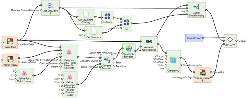
ERDAS IMAGINE 2022

Automated GCP Creation and Image Coregistration in Spatial Modeler Photogrammetry
Workflows
The IMAGINE Autosync product (now a part of IMAGINE Expansion Pack) is a set of tools for performing
automated image-to-image coregistration. The general premise is to have a highly spatially accurate reference
image that you want other imagery to line up with. To facilitate this, control points are automatically generated
matching features from the input imagery to the reference. These are then used to compute a geometric
model to transform the input imagery to the same spatial accuracy as the reference. The model can be as
simple as an affine, or as complex as an orbital pushbroom satellite sensor model for orthorectification.

In ERDAS IMAGINE 2022 we have added new operators to Spatial Modeler (as well as updating existing
ones) to replicate this capability in spatial models, which can be used to further automate the coregistration
process.

For example, here are two QuickBird images (courtesy of DigitalGlobe) that do not align closely using their
basic geometry when they are overlaid and the Swipe tool is activated:

21 October 2021                                                                                                  13
ERDAS IMAGINE 2022

The following Spatial Model was constructed to take the data, treat one image as the reference, and generate
ground control points automatically to tie the other image to the reference. Those GCPs are then used to
update the Rational Functions (RPCs) and can be used either to produce an ortho-rectified output file or to
very quickly create a proxy header for the original image to more accurately position it.

The result is two images that overlay and Swipe much more accurately. It’s actually almost impossible to see
the difference between the two images expect where an airplane has been moved between the two dates the
images were captured:

21 October 2021                                                                                           14
ERDAS IMAGINE 2022

New Spatial Modeler Operators
Note that many of these new operators require additional licensing in order to run as part of a spatial model
execution. This is generally noted in the Help for each operator.

Add Control Points to Block

The Add Control Points to Block operator adds control points to a block. The added control points could be
used in Run Bundle Adjustment where the block is used as input.

Attribute Statistics

This operator computes basic statistics for a numeric attribute of the input features.

Calculate Flow Concentration

Note: This operator requires IMAGINE Advantage, IMAGINE Professional, GeoMedia Advantage, or
GeoMedia Professional licenses in order to run.

Calculate Flow Concentration operator is part of a collection of operators for hydrological analysis. It predicts
stream paths, with runoff being assumed to flow downhill from pixel to pixel. It is assumed that all runoff drains
as overland flow and that none of it is absorbed or evaporated. Runoff is usually considered water from rain,
snow-melt, and other sources.

Calculate Flow Concentration operates on a raster of continuous surface elevation data, such as a Digital
Elevation Model (DEM). The DEMRaster controls the downhill path through each pixel. The downhill direction
is the steepest slope out of the pixel (i.e, the greatest downhill elevation change leading out of the pixel into
the eight adjacent pixels). If two or more adjacent pixels have the same lowest value, then the flow is divided
evenly among them. If none of the adjacent pixels is lower, then flow stops. Each pixel of the
FlowConcentrationRaster represents the amount of runoff passing through a pixel.

21 October 2021                                                                                                 15
ERDAS IMAGINE 2022

Calculate Processing Quantity

The quantity computed by Calculate Processing Quantity is useful for constructing high-performance spatial
models. Given an input, the operator uses the supplied maximum available resources, typically obtained from
the Get Iterator Execution Method Resources operator, to compute a quantity that allows the input to be
processed in a number of iterations that matches those resources.

The computed quantity is intended to be used with a data-dividing operator appropriate for the input type.
Thus, the units of the quantity are dependent on the input type. For example, if the input is IMAGINE.Raster,
the computed quantity is intended to be used as the SizeLimit input to the Create Dice Boundaries operator
and, thus, the units are bytes.

Classify Features

This operator classifies features by applying multiple attribute-based filters that assign them to corresponding
classes.

Convolve Fuzzy Classifications

The Convolve Fuzzy Classifications operator computes a single-band classification using a convolution-based
algorithm and fuzzy inputs. This operator supports GPU acceleration.

Tools such as ERDAS IMAGINE's Supervised Classification dialog can produce fuzzy classifications. A
traditional classification is one where a single band thematic classification is produced (with an optional
corresponding distance image) where each pixel is coded as the most likely (shortest distance) class value at
that location. The optional distance file can be used to threshold low-confidence (large distance) locations to a
background or NoData assignment. But there is only ever a single possible class per pixel. Conversely, a
fuzzy classification extends this concept by producing n thematic bands of classified values where the second
band represents the second most likely class at the pixel location, the third band represents the third most
likely class at the pixel location, etc. Similarly, the distance image contains n continuous bands, where the
second band represents the distance of the class value assigned in the second thematic class image, etc.
These additional bands of classification and distance are generally intended for further analysis and
processing to produce a final single-band classification.

21 October 2021                                                                                               16
ERDAS IMAGINE 2022

The Fuzzy Convolution operation creates a single-band classification by calculating the total weighted inverse
distance of all the classes in a window of pixels and assigning the center pixel the class with the largest total
inverse distance summed over the entire set of fuzzy classification bands. This has the effect of creating a
context-based classification to reduce the speckle, or "salt and pepper," in the classification.

Original classes with a very small distance value remain unchanged, while classes with higher distance values
may change to a neighboring value if there are a sufficient number of neighboring pixels with class values and
small corresponding distance values.

Define Control Points

This operator defines a dictionary of control points based on input features that represent ground points,
image names, and image points. A control point is a point with known or unknown ground coordinates and one
or more associated image locations. A ground control point (GCP) is a control point with known ground
coordinates.

Control Points can subsequently be used for purposes such as solving a geometric model and orthorectifying
an image.

Define Block Parameters For Mixed Sensor Model

This defines the dictionary needed to create a Mixed Sensor block. No user input is necessary; the operator is
simply creating the required dictionary.

The Mixed Sensor uses the existing 3D geometric model associated with each given image. In order to be
used in a Mixed Sensor block, the interior and exterior orientation of an image must be resolved. Images
falling into this category include calibrated images, oriented images, SOCET SET support files with known 3D
geometric models, or any images with a 3D geometric model automatically recognized by ERDAS IMAGINE.
Images in a Mixed Sensor block could be used for photogrammetric operations such as ortho rectification and
mosaicking.

21 October 2021                                                                                                17
ERDAS IMAGINE 2022

Define Continuity Model Parameters

This operator defines the parameters of a continuity model to be used by the Interpolate Using
Kriging operator.

Define Focal Parameters

Many focal operations (such as Convolve Fuzzy Classifications) can be constrained to apply only at target
pixel locations with specific classes (DN values) or to consider only certain classes (DN values) in the moving
window centered on the target pixel. To facilitate defining such constraints, the Define Focal Parameters
operator can be used to create a dictionary of the desired parameters. As such, the Define Focal Parameters
operator does not apply any processing itself, other than to create the dictionary of focal parameters.

Generate Control Points Based On Reference

Note: This operator requires IMAGINE Expansion Pack licenses in order to run.

This operator generates control points by automatically identifying common locations between an image and
reference imagery.

21 October 2021                                                                                              18
ERDAS IMAGINE 2022

Generate Deep Learning Training Chips

This operator creates training chips suitable for use in Deep Learning-based operators. The training chips are
created from a raster stream containing the pixels for the samples and a feature stream describing the
locations and class names of the training samples in the raster stream. The geometries in FeaturesIn must be
area geometries whose bounding box will be used for subsetting the raster to generate the training chips. The
exact bounding box will vary based on LearningType.

The areas denoted by the geometries should be relatively small (e.g., 256 X 256 pixels) and approximately
square to be most useful to the deep learning algorithm. If the sample areas are large, they should be broken
up into smaller pieces. For example, to indicate a river area, several small patches containing the river should
be used rather than a single geometry covering the entire river.

Generate Stereo Pairs

The Generate Stereo Pairs operator generates a list of images from a block or list of oriented rasters that form
stereo pairs. Stereo pairs can be used in other operators for tasks such as deriving a point cloud.

Generate Topology Features

The Generate Topology Features operator generates new features representing the topological base elements
(faces, edges, and nodes) derived from all input area, line, point, and vector features.

21 October 2021                                                                                               19
ERDAS IMAGINE 2022

Get Dictionary Names

An IMAGINE.Dictionary consists of pairs of data: unique names (representing keys) and the corresponding
values for those names. The Get Dictionary Names operator takes in a dictionary and produces a list of all the
unique names present in that dictionary.

For example, if you wished to know the names of all the attribute fields present in a thematic raster, you could
use the Get Dictionary Names operator to generate the list in this manner:

Get Iterator Execution Method Resources

The resources value determined by Get Iterator Execution Method Resources may be useful for constructing
high-performance spatial models when used in conjunction with Calculate Processing Quantity.

Interpolate Using Kriging

Note: This operator requires IMAGINE Advantage, IMAGINE Professional, GeoMedia Advantage, or
GeoMedia Professional licenses in order to run.

21 October 2021                                                                                               20
ERDAS IMAGINE 2022

This operator takes a raster of sparse data and uses an ordinary kriging operation to estimate the unknown
data values.

Read Digital Camera Parameters From ORIMA File

Reads digital camera parameters needed to set up a digital camera from an ORIMA camera file.

Read Frame Camera Parameters From ORIMA File

Reads frame camera parameters needed to set up a frame camera from an ORIMA camera file.

Read Image Parameters For Mixed Sensor Model

Reads the existing geometric model associated with a given image file and returns a dictionary containing the
image name. The model associated with the image must support the ground-to-image 3D transformation: for
example, a DIMAP image with associated RPCs.

21 October 2021                                                                                              21
ERDAS IMAGINE 2022

Updated Spatial Modeler Operators

Associate Georeference

The Associate Georeference operator has been enhanced to support features as input. The operator
associates georeferencing information with a raster or features, replacing all or in part any information that had
previously been associated.

Cell Area/Cell X/Cell Y/Orthorectify

The Units port on these four operators has been updated with a dialog that provides a picklist of the
acceptable values rather than relying on the user knowing what the values might be and manually typing them
into the Properties panel.

Compute Transform

This operator takes control points and their measurements in an image and creates a transform from the
image coordinate system to the control point coordinate system.

It has been enhanced with a new RSMEThreshold port. If the RMSE error computed for the output transform
exceeds the RMSEThreshold, the operator execution will fail.

It has also been enhanced to support Rational Function and Orbital Pushbroom as TransformTypes for
performing orthorectification.

21 October 2021                                                                                                22
ERDAS IMAGINE 2022

Convert

The DataType port on this operator has been updated with a dialog that provides a picklist of the acceptable
values rather than relying on the user knowing what the values might be and manually typing them into the
Properties panel.

Convert to Features

The Convert to Features operator has been enhanced to allow a raster input to be converted to point features
(one point per pixel), maintaining DN values and attributes from the raster as additional attribute fields in the
features.

This type of conversion is useful in many scenarios, but one of the most common is creating training data for
the machine learning operators in Spatial Modeler. The machine learning operators in Spatial Modeler largely
work only with attribute information (any geometries are not themselves used — it's simply a large table of

21 October 2021                                                                                                23
ERDAS IMAGINE 2022

numbers to find patterns in) and needs lots of data from which to learn. If you want to train based on attributes
derived from an image, you really want a point per pixel for "known training." But generally, when you are
trying to train a classifier, you have polygonal training data. You know which field boundaries contain which
arable crops, which segments contain water, etc. Like this:

Every pixel that falls within, say, a "forest" polygon represents numerical information (the per-band DN values)
that can be used to train a machine learning classifier on what characteristics are representative of "forest."
But the polygon is only a single feature in the features database, so if you attempted to use the above forest
polygons (area geometries) to train a Random Forest classifier, you'd only have 5 or so entries in the features
from which to learn. You would have to use attributes that were the mean and SD (or other statistical
measures) of all the pixel values that fell in each of the five forest polygons.

Converting the image pixels that fall within the polygon directly to attributed point features provides a very
efficient means of generating the necessary training data.

21 October 2021                                                                                                  24
ERDAS IMAGINE 2022

Convert to Raster

The Convert to Raster has been re-implemented (and the old version deprecated) to provide greater and more
predictable control over which pixels will be included.

This includes a new InclusionRule port allowing the pixel inclusion rule for area geometries to be swapped
between the old (and still default) “Vertex or half pixel edge” rule and a new “Center of cell” rule.

    •   Vertex or half pixel edge – a pixel is included if it contains a vertex or if at least half of one of the
        pixel's four edges lies within or on the boundary of the area geometry.

21 October 2021                                                                                                     25
ERDAS IMAGINE 2022 • Center of cell – a pixel is included if its center falls within or on the boundary of the area geometry. Any pixels that are not included in the geometry are set to NoData. Create SGM Point Cloud Note: This operator requires an IMAGINE DSM Extractor license in order to run. The Create SGM Point Cloud operator extracts a dense point cloud from a pair of stereo images using Semi- Global Matching (SGM). The input images must have associated 3D model information and be in the same CRS. The operator has been enhanced by adding a new SurfaceType port. The port can be used to specify whether to generate a sharp or smooth surface. 21 October 2021 26
ERDAS IMAGINE 2022

Smooth surfaces are generally open landscapes that are characterized by gradual changes in the terrain with
few or no human-made structures, while sharp surfaces are those that have significant human-made
structures built on them (such as urban areas).

Custom Matrix Input

The Custom Matrix Input operator’s Matrix Source dialog has been updated to have options similar to those
provided by the Raster tab > Supervised menu > Fuzzy Convolution dialog to assist in defining cell values for
distance weighted kernels.

21 October 2021                                                                                            27
ERDAS IMAGINE 2022

Define Adjustment Options For Orbital Pushbroom Model

This operator assembles the options that can be used to affect the results of the bundle adjustment process
when run on orbital pushbroom model blocks.

The operator has been enhanced by adding a new PolynomialOrders port. The polynomial orders are used for
the six exterior orientation parameters in the adjustment model. These should be specified in the order X, Y, Z,
Omega, Phi, Kappa and will override any image-specific orders that have been specified.

Define Image Parameters For Rational Function Model

The CoefficientOrder port has been updated to enable the RPC coefficients to be defined in ether the form
native to ERDAS IMAGINE or that used by the RPC00B definition.

21 October 2021                                                                                               28
ERDAS IMAGINE 2022

Define Mosaic Input Options

The Define Mosaic Input Options operator defines input options used with the Mosaic Images operator.

Two new ports, VertexThreshold and Tolerance, have been added to it.

When the active area of an image is computed using the Edges method, the computed active area polygon
will have as many vertices as necessary to accurately describe the active area boundaries. A possible
drawback of the Edges method is that the computed active areas can be complex with a large number of
vertices, which impacts the performance of the mosaicking process. In most cases, such accuracy is
unnecessary, and the active area polygon can be simplified to have fewer vertices safely. The simplification is
controlled using the newly added ports.

Define Point Match Options

This operator defines the point match options to be used with point generating operators such as Generate Tie
Points and Generate Control Points Based On Reference.

The operator has been enhanced by adding several new ports for specifying options. These new ports can be
used for point generation with Generate Control Points Based On Reference operator.

21 October 2021                                                                                              29
ERDAS IMAGINE 2022

Dictionary Item
The Dictionary Item operator’s Select Dictionary Items dialog has been updated with a Search field to make it
far easier to find the specific Key/Value parameter you are looking for.

GeoPackage, File Geodatabase, and CSV support in Features Input and Features Output

The GeoPackage and File Geodatabase formats are now supported for input and output of Features data in
Spatial Modeler.

CSV support has also been improved to support WKT geometry definitions.

21 October 2021                                                                                            30
ERDAS IMAGINE 2022

Get JPEG 2000 Options

A new IncludeMaskChannel port enables definition of whether or not to include a mask channel (representing
NoData locations) in the output image file if it is written to the JPEG 2000 (JP2) format.

Spatial Model Editor Interface Improvements
The Spatial Model Editor has been enhanced with various new features to assist in the creation, editing, and
update of complex Spatial Models. These include the following:

Reorganized Spatial Modeler Ribbon Tab
The Spatial Modeler Ribbon tab has been reorganized to better accommodate the newly added buttons, which
support the following features. The Find and Align tools have been added to the Editing group. The various
options for showing and hiding elements of the graph have been moved a Show pulldown, and a new Library
group that provides a list of links to useful references has been added.

Search a Model For An Operator

A Navigation panel is now provided to assist in searching and finding specific operators within a Spatial Model
and driving to their locations. This is particularly useful when building and testing very large and complex
models.

21 October 2021                                                                                             31
ERDAS IMAGINE 2022

The Mouse Cursor Reflects if a GUI is Available

The mouse pointer will now change from the regular pointer to a hand icon if moved over a Port or Operator
that can be double-clicked to invoke a dialog.

Open Non-spatial Model/Operator Outputs in a Dialog
For example, in the Spatial Model shown above for the Get Dictionary Names operator, we had this model:

The user can now right-click on the output Names port (which by default just shows ), select View
Data.., and see the attribute field names for the input raster:

This is useful for quickly checking that your Spatial Model is producing the expected information on a specific
output port.

Connect Two Widely Separated Operator Ports
When building large, complex models, you often find yourself adding a new operator on the right side of the
model, which requires inputs from several other operators. Some of them might be close, by but others might
be all the way back on the left side of the model. Connecting such widely separated operators can be a
cumbersome task, usually involving moving the new operator back and forth.

21 October 2021                                                                                              32
ERDAS IMAGINE 2022

With Spatial Modeler 2022, right-click menus on ports provide two new options: Connect From and Connect
To. This enables the person constructing the complex model to right click on an input port of that new operator
on the right of the model and pick Connect To, and then scroll over to the left of the model, right click on the
appropriate output port and select Connect From, and the two widely separated operators will be connected.

Align Operators Functions
To assist in organizing your spatial models, a new set of alignment tools have been provided.

21 October 2021                                                                                              33
ERDAS IMAGINE 2022

These enable you go quickly reorganize selected operators from something that looks like this:

21 October 2021                                                                                  34
ERDAS IMAGINE 2022

To this, using Align Horizontal Left and then Distribute Vertically:

21 October 2021                                                                        35
ERDAS IMAGINE 2022

Save As to Python script
As well as being able to use Python scripts within a Spatial Model (for example, via the Python Script
operator), you have also been able to use Spatial Model operator within Python Scripts. This latter capability
has been made easier with the ability to directly save a Spatial Model to a Python script, which can be used
as-is or modified with other Python capabilities.

Center Dialogs on Same Screen as Spatial Model Editor
ERDAS IMAGINE and Spatial Model Editor have always supported being opened on any configured display
screen. However, some dialogs that were invoked (such as a Run dialog) would appear on the primary display
even if called from a secondary display, causing some confusion. Spatial Model Editor has been updated in an
effort to ensure that all dialogs appear on the same display as they were called from.

21 October 2021                                                                                              36
ERDAS IMAGINE 2022

Format Support

Landsat 4, 5, 7, and 8 from USGS
The USGS has begun producing Collection 2 data for the Landsat program via the EarthExplorer service.
Unlike older products (which are also still available for download), which were delivered as .tar.gz files, the
Collection 2 data is delivered as .tar files, with several other formatting changes.

Consequently, the Landsat 4, 5, 7 and 8 from USGS importer dialog has been overhauled to accommodate
the new Collection 2 data, as well as several other changes in the types of data made available for download
from EarthExplorer. The changes should also make the importer Landsat 9 ready, but of course there is not
yet any data available against which to verify this.

JPEG 2000 NoData Mask
ERDAS IMAGINE has previously always included a NoData mask (also sometimes referred to as an alpha
channel) when creating JPEG 2000 (JP2) format files. However, some customers expressed concerns over
the inclusion of the NoData mask (because apparently some other geospatial softwares cannot interpret the
format correctly), and so an option has been added to specify to not add the NoData mask.

This option is available in the JPEG 2000 Exporter dialog, as well as there being a Preference to control the
behavior when writing directly to JP2. The Spatial Modeler’s Get JPEG 2000 Options operator has also been
enhanced with a port to allow control of the mask creation on output.

DIMAP v2
DIMAP v2 formatted satellite imagery (such as Pleiades and SPOT 7) should now open and display more
efficiently.

SRTM HGT
SRTM HGT elevation data is now readable in Spatial Modeler, as well as being displayable via the Image
Chain rendering engine in 2D Views.

Esri File Geodatabase
Esri File Geodatabase (*.fgd) vector features are now readable in Spatial Modeler, as well as being
displayable in 2D Views.

SIDD 1.1
The SIX SICD/SIDD libraries, as well as the SIDD schema files, have been updated to add support for SIDD
1.1

NITF
SECURA TRE is now decoded.

Reading and displaying JPEG 2000 encoded NITF imagery that has more than three bands (such as 8-band
WorldView-2) has been parallelized for greater efficiency.

Features from S3 Bucket
Previously, support had been added for raster data available in S3 buckets. This has now been extended to
include vector features such as shapefiles.

21 October 2021                                                                                                   37
ERDAS IMAGINE 2022

General ERDAS IMAGINE

SIPS v2.4.16
We have updated the installer to use the Unclassified SIPS v2.4.16 XML file to control default Image Chain
display parameters.

You can acquire extended versions of SIPS via the IMAGINE Defense Productivity Module (DPM) or by
replacing the appropriate XML file.

Inquire Box Improvements
The Inquire Box now more accurately visually depicts the “file rectangle” encompassed by the box on
geometrically calibrated or rotated imagery. This means that when performing operations such as a Subset or
Chip, the box better represents the area that you will see in the output.

Filename Case Retention
Previously, ERDAS IMAGINE and Spatial Model have always converted any filenames entered for new output
files into all lowercase (even though the software could recognize and ingest filenames that used mixed case).
This has been corrected to retain the case you specify.

For example, if you specify you want an output file called “AluminiumOreLocations.img” you will now get a file
called “AluminiumOreLocations.img.”

21 October 2021                                                                                              38
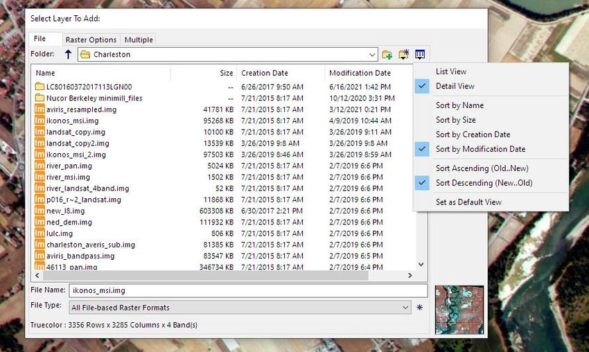
ERDAS IMAGINE 2022

File Chooser Improvements
The File Chooser has been improved in several different ways. It now remembers settings for size, it provides
more and easier to understand actions for the current folder, it introduces a Detail view to provide more
information about the files in the current view, and it provides access to the recently visited folders in the folder
pulldown menu.

The last size of the dialog is remembered (by automatic recording to a User Preference) and recalled
whenever the dialog is opened. If you prefer a larger view, just stretch the dialog once, and it will come back
the same size the next time the dialog is opened.

In addition to setting the current folder as the Default Input or Default Output folder, the path to the current
folder can be copied to the copy/paste buffer for use in other places, and the current folder can be opened in
the Windows File Explorer.

The Folder pulldown list has several improvements. It provides two new shortcuts to the Desktop and to the
Downloads folder, as these are commonly the location of newly received data. It also provides the list of
recently visited folders so that going to a previous folder is now a simple two-click operation.

A Detail view has been added that shows the name, size, creation date, and modification date of files (sizes
are not available for folders). The view can be sorted by any of these fields in ascending or descending order.
There is a new button that displays the menu from which these settings are made. The view mode is saved
(for the current session) for each of the folders visited and will be used whenever that folder is viewed again
from within the current session. The view settings can be saved and will become the default view.

21 October 2021                                                                                                   39
ERDAS IMAGINE 2022

GPU Acceleration
Several operators in Spatial Modeler have been reimplemented to use GPU acceleration (usually CUDA-
based) to increase the efficiency and reliability of execution.

For example, the Compute GLCM Texture operator has been reimplemented in CUDA rather than OpenCL,
leading to more reliable usage of available memory for accelerated processing.

The Enhance Contrast Using CLAHE operator has been re-implemented to use GPU acceleration. Tests have
shown the new operator to be more than 15 times faster than the prior version.

The following Focal operators have also been refactored:

   •   Focal Min

   •   Focal Max

   •   Focal Mean

   •   Focal Standard Deviation

   •   Focal Majority

   •   Focal Minority

The Fuzzy Convolution tool was also refactored, but little difference was seen between the GPU and CPU
implementations. However, the new CPU implementation proved to be more than three times faster than the
old implementation.

Projected Coordinate Systems (PCS)
The following PCS have been added or enhanced:

   •   EPSG codes for Portuguese islands (EPSG 5013, 5014, 5015, and 5016) have been added.

   •   GEOID18 has been added.

   •   Puerto Rico Vertical Datum of 2002 (PRVD02) has been added.

   •   Virgin Islands Vertical Datum of 2009 (VIVD09) has been added.

   •   ITRF2014, the new realization of the International Terrestrial Reference System, is now supported.

MosaicPro
Active areas computed using the Edges method can now be cropped.

21 October 2021                                                                                             40
ERDAS IMAGINE 2022

SAR Functionality
Radar imagery continues to be a growing and important source of geospatial information and remains an area
of development for Hexagon. In ERDAS IMAGINE 2022, we have added the following capabilities:

Beta 0
The Beta 0 radiometric conversion is now supported for most common commercial radar sensors.

Sigma 0
The Sigma 0 radiometric conversion is now supported for most common commercial radar sensors.

E-Z Coherence Change
The E-Z Coherence Change tool now allows selection of which products to generate (ILU, Coherence Texture,
or Multi Temporal Coherence) rather than generating them all, allowing more efficient processing for just the
information of interest.

Sentinel-1 GRD
Previously, Sentinel-1 GRD products used the relatively inaccurate georeferencing information embedded in
the TIFF file. The software has been enhanced to create a SAR sensor model using the header information for
more accurate georeferencing.

Sentinel-1 Image Formation
An improved algorithm for assembling bursts into a single continuous image has been implemented.

Capella
The Capella SAR sensor model has been updated to use the header information provided by the most
recently acquired example imagery. Positional accuracy is improved to +/- 1 pixel in most cases.

The Capella format reader now supports the GEC product in JSON format and data in the SICD format.

The Coregister Radar Images tool now works with Capella GEO data.

Capella SLC files will now open as Magnitude and Phase components and can be used for interferometric
processing.

ICEYE
ICEYE SLC files (in HDF5 format) will now open as Magnitude and Phase components and can be used for
interferometric processing.

COSMO SkyMed Second Generation (CSG)
CSG imagery can be read and displayed.

21 October 2021                                                                                           41
ERDAS IMAGINE 2022

System Requirements
ERDAS IMAGINE
                                64-bit: Intel 64 (EM64T), AMD 64, or equivalent (four or more logical processors are strongly
 Computer/ Processor
                                recommended)
 Memory (RAM)                   16 GB or more strongly recommended

                                  •    6 GB for software
 Disk Space                       •    7 GB for example data
                                  •    Data storage requirements vary by mapping project1

                                  •    Windows 10 Pro (64-bit)
                                  •    Windows 10 Enterprise (64-bit)
 Operating Systems    2, 3, 4
                                  •    Windows Server 2019 (64-bit)
                                  •    Windows Server 2022 (64-bit)
                                  •    Windows 11 Enterprise (64-bit) (Windows Insider Program pre-release version)

                                  •    OpenGL 2.1 or higher (this typically comes with supported graphics cards 5)
                                  •    Java Runtime 1.7.0.80 or higher — IMAGINE Objective requires JRE and can utilize any
                                       installed and configured JRE of version 1.7.0.80 or higher. Microsoft Visual C++ 2010 x64
                                       Redistributable is also required.
                                  •    Python 3.7.x (Python is optionally usable with Spatial Modeler)
 Software                         •    Microsoft DirectX® 9c or higher
                                  •    .NET Framework 4.7.2 or higher
                                  •    OpenCL 1.2 with a device that supports double precision (cl_khr_fp64) if wanting to GPU
                                       accelerate NNDiffuse and other Operators
                                  •    An NVIDIA card with CUDA capabilities is recommended for use with Deep Learning and other
                                       Operators

                                  •    NVIDIA® Quadro® P6000, P5000, P4000, P2000
 Recommended                      •    NVIDIA® Quadro® M6000, M5000, M4000, M2000
 Graphics Cards for
 Stereo Display6                  •    NVIDIA® Quadro® K5200, K5000, K4200, K4000, K2200, K600, K420
                                  •    NVIDIA Quadro RTX4000

                                  •    120 Hz (or above) LCD Monitors with NVIDIA 3D Vision™ Kit, or
 Recommended Stereo
                                  •    3D PluraView system from Schneider Digital7
 Display Monitors
                                  •    Vision Engineering CONTOUR 3D stereoscopic GIS display

 Recommended Stereo               •    NVIDIA 3D Vision™ Kit
 Glasses and Emitter kits         •    3DTV Universal Emitter

                                All software installations require:
                                  •    One Windows-compatible mouse with scroll wheel or equivalent input device
                                  •    Printing requires Windows-supported hardcopy devices8
                                Software security (Hexagon Geospatial Licensing 2022) requires one of the following:
                                  •    Ethernet card, or
 Peripherals
                                  •    One USB port for hardware key
                                Advanced data collection requires one of the following hand controllers:9
                                  •    TopoMouse™ or TopoMouse USB™
                                  •    Immersion 3D Mouse
                                  •    MOUSE-TRAK

21 October 2021                                                                                                                    42
You can also read