Round and Round Australia (1989 to 2001): 11,761 Beaches - Allen Press
←
→
Page content transcription
If your browser does not render page correctly, please read the page content below
Short

        Round and Round Australia (1989 to 2001): 11,761 Beaches

                                        Andrew D. Short*

      Coastal Studies Unit, School of Geosciences, University of Sydney, NSW, Australia

                                          INTRODUCTION
  Between 1988 and 2004, I had the task of investigating and documenting all the beaches around the
Australian mainland and 30 of its major islands, in all a total of 11,761 beach systems. The project
started as the New South Wales, then Australian Beach Safety and Management Program
(ABSAMP), in collaboration with Surf Life Saving Australia (SLSA), Australia’s peak coastal water
safety authority. SLSA was interested in hazards to swimmers and surfers on these beaches, while I
was also interested in their geology, geomorphology and morphodynamics, as well as their
associated barrier systems. The project was undertaken using four approaches: in-house, on land, in
the air and on the sea. In-house, I had a complete set of black and white aerial photographs (pre-
Google Earth) of the entire coast (courtesy of Professor J.K. [Jack] Davies), a complete set of the
largest scale topographic and geological maps and all available literature. On land, my family and I
visited all beaches that were accessible by road and reasonably accessible by 4WD vehicle. In the air,
I photographed every beach from a series of small planes, with either the window open and/or a door
off, and the longest flight sequence lasting 12 days and covering half the coast. At sea, I undertook a
series of trips in small boats that covered much of the southeast, east and all of the northern coast.
The following describes a few of the more interesting events that occurred during this time.

1989 Wipeout on the Narooma Bar
  Around the Australian coast there are many sections which are essentially undeveloped and have
no vehicle access, so if you want to investigate the coast you need a boat. With this in mind, between
1989 and 2001, I undertook eight trips in small boats that eventually covered 13,700 km, almost half
of the 30,000 km long mainland Australian coast. The boat trips started in the state of Victoria
(Figure 1) and after successfully investigating the Great Ocean Road coast, either side of Cape
Otway (Figure 2), and the Wilson’s Promontory coast, in December 1989, I set out from Mallacoota
on the eastern Victorian Bass Strait coast on a 700 km trip up the southern New South Wales (NSW)
coast. The boat was a 4 m long inflatable steered by Andrew May from Surf Life Saving NSW, with
me sitting in front of the steering wheel (Figure 3).

  The objective was to land on and inspect beaches (Short, 1993, 2007) that were inaccessible or
difficult to access from the land. This included taking ground photos, collecting sand samples and
gradients and noting the overall beach and surf zone morphology. As there was usually a good surf
running when we approached each beach, I would slide overboard and swim/surf ashore and then
back out to the boat. We had a good run up along the uninhabited Nadgee Nature Reserve coast and
stopped at Eden, NSW the first night, where we were met by our backup, Chris Hogan, who towed
the boat trailer and arranged accommodation. As we had no ship-to-shore communication, we had to
hope we made it to each rendezvous point each day, which on some trips was not always the case.
The second day while landing at Tura Head beach, I slid overboard only to see the boat turn tightly
and head straight for me! I quickly did a duck dive and my heel was just clipped by the propeller,
cutting my rubber boot and just slicing my heel, but not reaching the bone. That night I got it stitched
up at our next stop at Tathra. The following day we ended up entering the infamous Narooma bar,

DOI: 10.2112/JCR-SI101-041.1
*Corresponding author: andrew.short@sydney.edu.au
©
  Coastal Education and Research Foundation, Inc. 2020

                                                    216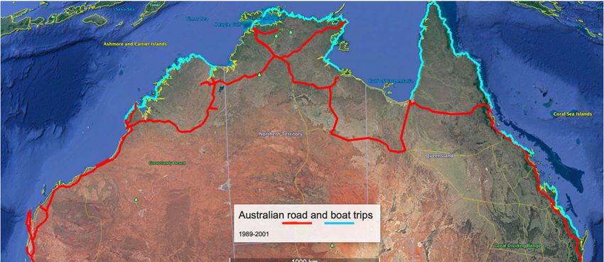
Journal of Coastal Research, Special Issue No. 101, 2020
site of many wrecked boats and drownings in its narrow 50 m wide entrance between two high rock
training walls (jetties). [Of note, do a Google search for ‘Narooma bar boat accidents’ ‒ and while
writing this piece another two fisherman drowned when their boat overturned on the Bar.] There was
a good north swell running and breaking on the entrance bar, but we made it in, only to be asked at
the wharf if we were SCUBA divers and if so could we go back out and look for a small fishing boat
that had overturned and sunk on the bar (fortunately with no fatalities) earlier in the day. Not having
SCUBA gear, we were unable to assist.
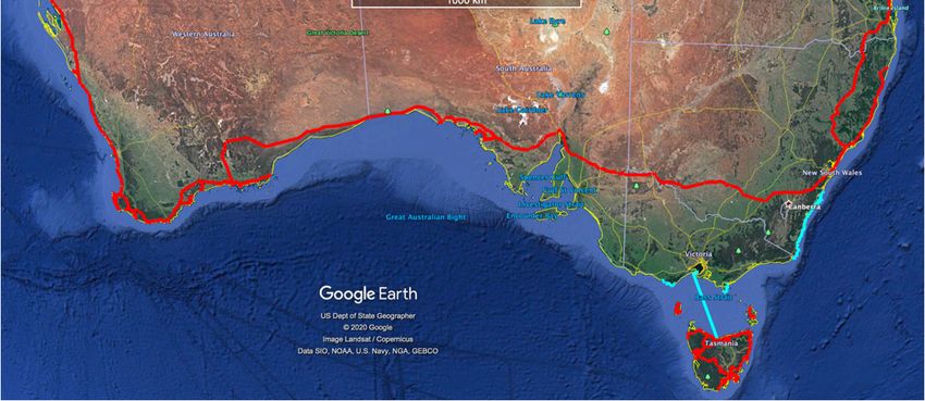
Figure 1. Google Earth images of Australia showing the 1991 land based (red) and most of the sea based (blue) field
trips. (Source: Google Earth.)
Next morning the swell had cleaned up, but still had some sizable sets, so Andrew and I drove our
vehicle to the end of the training wall and looked at the bar for a while checking it for lulls between
sets. I told Andrew the plan was to motor to the inside of the entrance and wait for a set to pass then
gun-it out in the ensuing lull. All sounded fine. We got in the boat, motored to the entrance and
without a blink Andrew just kept going seaward as a large wave approached, peaking as a 3 m+ A-
frame, across the bar. We headed straight into and up the near vertical face with the wave then
breaking over the boat, which I thought was going to flip. The breaking wave washed me overboard
while Andrew held onto the steering wheel and somehow he and the boat landed on the other side.
217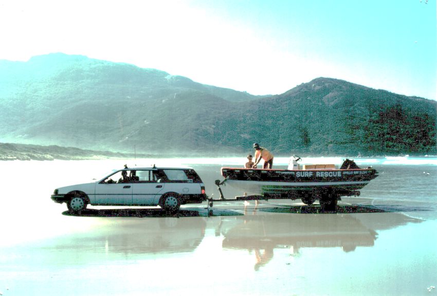
Short

He looked back to see my head bobbing in the foam, covered in blood and assumed the worst. As I
was washed off, the wave had stripped away my Ray Ban sunglasses, in the process skinning my
nose, which was the source of the blood. The wave was followed by the expected lull and after
climbing back on the boat we continued our trip with a few more minor mishaps, but no more blood.
I never asked Andrew to pilot another boat.

Figure 2. Launching the surf rescue boat used on the Victorian coastal trips at Tidal River (Wilsons Promontory) prior to
rounding and landing on South Point the southern tip of the continent. (Photo: A.D. Short.)

  a                                                  b

Figure 3. (a) Andrew May and Andy Short starting off at Mallacoota. (b) Crossing the Mallacoota bar at the start of their
700 km run up the southern NSW coast. (Photos: C. Hogan.)

1991 Check the Surf
  The most memorable land trip was with my family in 1991, when we set off in a 100 Series
Landcruiser towing a 23 ft caravan, containing my wife Julia and our three young children (Figure
4). The trip lasted 5 months, covered 30,000 km and involved inspecting several hundred beaches in
Western Australia, the Northern Territory and Queensland. One of the more memorable incidents
was when we drove out in a convoy of four cars to Nhulunbuy (Gove), a remote bauxite mining town
in the Northern Territory, across the large aboriginal-controlled Arnhem Land, where permits are

                                                          218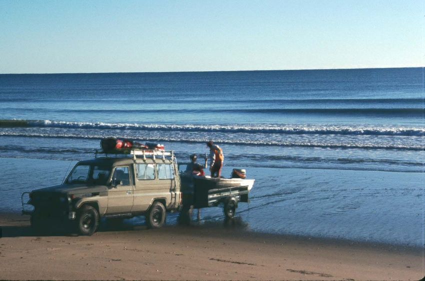
Journal of Coastal Research, Special Issue No. 101, 2020

required to enter and cross. From the highway to Gove is a 700 km drive on dirt and sandy tracks,
which usually takes three days. However, our trip coincided with the Northern Territory (NT) Surf
Lifesaving Championships, and the head of Surf Life Saving NT was also the NT Minister for
Roads, Fred Finch MP. Well, Fred had the Arnhem track graded in anticipation of the convoy of surf
club vehicles heading from Darwin to Gove, including his. As a result, the three-day trip became a
non-stop 11-hour drive.

  As there are no tourist facilities at Gove, we camped on the lawn at the Gove Surf Lifesaving Club.
The next day was the start of the championships and we went down to the adjacent beach with our
children to let them have a swim. They were allowed to represent the Darwin Surf Lifesaving Club
(one of the two NT surf clubs) as at home they were members of our local North Narrabeen surf
club. They raced into the low surf and murky water having a great time. It was then we realised that
while there were dozens of people and children on the beach, no one else was in the water apart from
our kids and two lifesavers, wearing full lycra suits towing a net though the surf and another
scanning the surf from a shark tower. On making inquiries we were told the net was to see if there
were any deadly marine stingers (jellyfish) in the water, while the lookout was checking, not for
sharks, but for crocodiles. With that we decided to call the kids in until the all clear was given. It was
then that we were informed the only fatality at the beach had occurred the year before when a wild
buffalo gored a person near where we were camped!

  a                                                           b

Figure 4. (a) The Toyota 100 Series, caravan and Short family about to head off. (b) Field assistants Ben, Bonnie and Pip
Short at mangrove-lined Karumba beach, southern Gulf of Carpentaria. (Photos: A.D. Short.)

By Tinny to Cooktown
  The more remote beaches on the east Queensland coast between Burrum Heads and Cooktown,
3000 km to the north, were investigated using small two aluminium boats, called tinny’s in Australia.
The first trip in mid-1990 (Figure 5a) had ongoing motor problems and the boat part ended in
Caldwell after which we travelled by road to Cooktown. The second in mid-1994, despite a leaky
boat (Figure 5b) made it all the way to Cooktown by sea.

                     1998-2001 NORTHERN AUSTRALIAN FIELD WORK
   The tropical north coast of Australia is 11,900 km long, remote and largely undeveloped and
uninhabited apart from scattered aboriginal communities, very large pastoral stations and a few
seasonal fishing camps. There are few roads reaching the coast so the best way to work the coast and
its 3500 beaches was again by small boat. The northern boat trips (three in total) were funded in part
by the Australian Research Council and the (Australian) Defence Science and Technology
Organisation (DSTO) and supported by SLSA.

                                                          219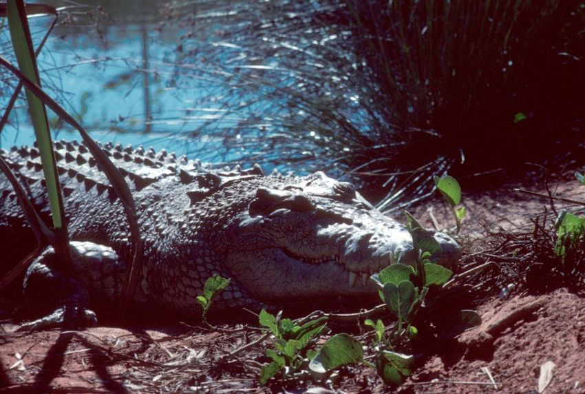
Short

  a                                                            b

Figure 5. In 1990, two small boats were used to traverse the Queensland coast from Burrum Heads 3000 km north to
Cooktown. Shown here is: (a) The first trip launching at Moore Park beach; and (b) Another beach landing in a leaking
boat on Pancake Point. (Photos: A.D. Short.)

  In addition to assessing the beach systems, I needed to conduct inshore bathymetric surveys and
bottom sampling for the DSTO and I convinced the University of Sydney to fund a custom-made
8 m aluminium monohull with a half cabin powered initially by two 125 HP outboards, which were
replaced after the second trip with an inboard diesel jet engine (Figure 6). We first had to tow the
boat from Sydney to the start of each field winter trip: in 1998, 2400 km north to Cairns, Qld; in
1999, 3300 km northwest to Borroloola, which involved a return trip via Uluru (Figure 6b); and in
2001, a 10-day 4600 km drive northwest to Wyndham, WA.

  a                                     b                                     c

Figure 6. (a) The CSU 3 (truck and tinny) being launched at Mule Creek, NT at the start of the 1999 trip. (b) Enroute
home via Uluru at the end of the 1999 trip. (c) At Silica Beach on Hidden Island in the west Kimberley of Western
Australia during the 2001 trip, a rare pure white silica beach on an otherwise carbonate-dominated coast. (Photos: A.D.
Short.)

  The crew was myself and School of Geography, University of Sydney Technician, Graham Lloyd,
whose job was to drive and maintain the boat while I went ashore on the beaches. Because of
crocodiles, we lived, cooked and slept on the boat. Graham rarely left the boat during each trip, but
depending on wave conditions, tide stage and beach morphology, I daily walked, waded (Figure 6c)
or swam/surfed ashore to access the beaches just wearing speedos and booties and carrying a
waterproof notebook and a camera protected in a plastic bag. The trick was to check for crocodiles,
or as the locals would say ‘any logs that move’ (Figure 7), before landing. However, I think they
were smarter than us, because I would often land on an empty beach to find fresh crocodile tracks
(Figure 8a). Just in case, I also had a dive knife strapped to my leg. I also had a foothold inserted in
the starboard side of the boat so when I swam out to be picked up I could grab a rope, put my foot in
the hold and lift myself onto the boat while Graham manoeuvred in the shallow water/surf. Mud flats
were taboo as you would sink to your knees, or deeper, and slowly struggle to reach the beach,
hoping all the while that no hungry crocodiles were watching.

                                                         220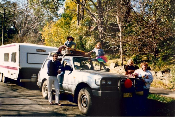
Journal of Coastal Research, Special Issue No. 101, 2020

  a                                                b

Figure 7. (a) It pays to check and take heed of the crocodile warning signs when working on the northern Australian
coast. (Photo: J.M. Short). (b) A nice sized saltwater crocodile having a nap. (Photo: A.D. Short.)

  One time on the eastern Cape York Peninsula, not finding a suitable mainland site to overnight, we
motored 10 km offshore to moor in lee of Night Island for the night. As it was a coral reef island
with a stand of mangroves, we were also going to have a snorkel around when we got there. Then
just as we manoeuvred to anchor in lee of the curving sand cay, a 3 m crocodile, which had been
sunning itself on the cay slid down the beach into the crystal-clear water and swam slowly under our
boat. Needless to say, snorkelling was put on hold.

 a                                                               b

Figure 8. (a) Saltwater crocodiles inhabit all of northern Australia and they, or their fresh foot and swerving tail prints,
are commonly seen on sandy beaches where they like to sunbake. (b) One of the supposedly hibernating crocodiles
checks out the boat on the northern Kimberley coast. They make beach work all that more interesting. (Photos: A.D.
Short.)

  In all the three trips, I landed on 500 beaches collecting sand samples, taking photos and noting a
range of morphological attributes. They were all uninhabited apart from the crocodile tracks and
numerous turtle nests. When the crocodiles got too nosey as I waited for the pickup, I would throw
rocks at them to keep them away, which seemed to work. I also encountered numerous (generally)
small sharks, but being a surfer, I was used to being in their domain and didn't consider them a
problem. Actually, the biggest issue was stingrays, which lie camouflaged in the sand just offshore of
many of the beaches. Here the trick is to shuffle though the sand and disturb them, rather than walk
and tread on one and suffer a barbed tail strike. While I saw many darting out of the sand around me

                                                           221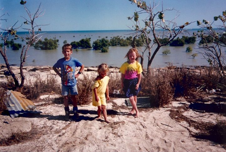
Short

I managed to stay clear of them, or them of me. Northern Australia has actually six S’s awaiting
those who venture into the water: sea snakes, stonefish, stingers, stingrays, sharks and of course
salties (i.e. saltwater crocodiles).

  The biggest issue in planning such trips was obtaining fuel as on the entire northern coast the only
dock side fuel was in Darwin. I had to arrange, usually by fax, for drums of fuel to be delivered to
mother ships or left at aboriginal communities and on the Kimberley coast at water-based pearl
farms, the latter being the best as they also freely opened their canteen to whatever we wanted, and in
the end sent no invoice for fuel (thanks Paspaleys!). In an era of pre-internet and pre-satellite phones,
this worked reasonably well, though at some communities it took a while to find out who was in
charge and where they had stored our fuel drums. Once in the Gulf of Carpentaria, we took on too
much fuel (i.e. spare fuel in 200 litre drums) and started to take on water. We made a beeline for a
nearby island and ran aground before we sunk and managed to sort things out. The most interesting
part was visiting the various communities and outposts, meeting the people who ran the place and a
few of the locals, hearing about life in these remote, predominately aboriginal areas, and getting
refuelled. I always found the people in these remote areas amongst the best I have ever met.

  On the 1998 trip around Cape York Peninsula (Cairns to Karumba, QLD), we would usually
anchor for the night inside a river mouth to get out of the swell. Most of the rivers were uninhabited,
but were generally the domain of a local fisherman and his crew, who would work out of a makeshift
winter camp and jealously guard their river. As our boat looked a bit official, usually not long after
we anchored we would get a visit from the owner to find out who were and what were we doing in
his river. Most looked like they had steamed out of the wild west with boats to match. However,
once I explained the purpose of our trip their attitude changed immediately and they never left us
without a gift of fish or live mud crabs. The latter they would just throw on our deck, which we then
had to catch and cook in an undersized pot.

  Our 1999 trip started in late July at a remote tidal creek at the end of a rutted track 60 km north of
the small predominately aboriginal community of Borroloola. We launched the boat at Mule Creek
(Figure 6a), then I drove the truck and trailer overnight 1000 km to Darwin, picked up a new Engel
fridge, followed by a flight back to the Macarthur River mine, then a pre-arranged lift out to the
creek mouth arriving back the following evening. Graham and I were finally ready to depart the
following morning. We were anchored in the creek on a falling tide (tide range 3 m), gradually
bottoming out in the shallow creek. Before we turned in however we noticed our small tinny which
had been tied to the stern had disappeared. Fortunately, using a torch we spied it 200 m upstream
against the shore.

   Knowing that if we waited till morning the next tide could take it seaward, we decide we had to get
it immediately. The issue was not the muddy creek floor, nor the 150 m of dense mangroves lining
the adjacent bank, it was the thought of crocodiles. Still we had to go, so with dive knives strapped to
our legs (we never took a gun) and torches in hand, on the count of three we both leap overboard and
started a slow muddy wade to the shore, followed by a muddy grope through the dense and dark
tangle of Rhizophora trunk roots with flashes of torch light lighting the way, all the while hoping
none reflected in a pair of blue crocodile eyes, until we finally reached the salt flats. From there it
was an easy and much relieved walk around the back of the mangroves to the cleared section of
shore where the tinny was stranded, and then a quick paddle back to the boat.

 Before the June 2001 Kimberley, WA trip, which covered 4300 km of coast from Wyndham to
Broome, I drove our truck and trailer 1000 km cross-country from Wyndham to Broome and left it
with Malcolm Douglas, a famous crocodile expert and documentary maker, who also ran a crocodile

                                                  222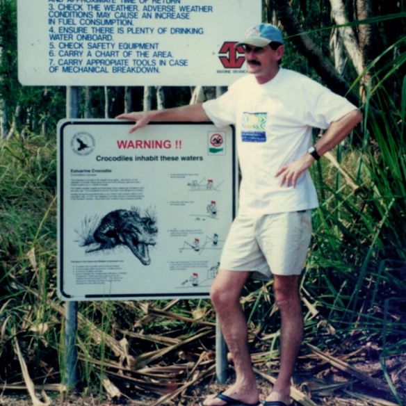
Journal of Coastal Research, Special Issue No. 101, 2020

farm in Broome (Short, 2020b). I naturally asked him about crocs and Malcolm, a big man with a big
booming voice, said, ‘This time of year (winter) there won’t be any, they will be hibernating.’ As it
turned out I saw lots of crocs and fresh croc tracks, so when we finally got back to Broome, after an
encounter with a mini-cyclone on the home leg, I asked Malcolm, ‘What about all these crocs I
saw?’ (Figure 8b). He replied, ‘How big were they?’ and I said, ‘Up to 2 m.’ He laughed and said,
‘They were tiddlers. I meant the big crocs are hibernating, the little ones are always about.’ ‘Thanks
Malcolm!’ Note: saltwater crocodiles grow up to 5 m and all are extremely dangerous, eating a few
people each year.

  After each trip, it was then the long drive back to Sydney (Figure 1) with my wife, Julia, flying up
to help me drive the rig back, while Graham flew home. The truck, a diesel twin-cab 4WD
Mitsubishi Canter (Figure 6a) never faulted, nor did the very sturdy triple-axle boat trailer. Some of
the results of all this work were published as a series of books on the beaches of each state/region
(Short, 1996, 2000, 2001, 2005, 2006a,b, 2007), followed by books covering the entire coast (Short,
2020a; Short and Woodroffe, 2009), and some journal publications (Short, 2006c, 2010, 2011). All
11,000 plus beach descriptions and images are at the core of a popular Beachsafe app produced by
Surf Life Saving Australia. Through all the air, land and sea trips and a total of more than 12 months
spent in the field, we never had any serious incidents, adventures or injuries.

 As Amundsen said, ‘Adventure is just bad planning.’

                                   LITERATURE CITED
Short, A.D., 1996. Beaches of the Victorian Coast and Port Phillip Bay. Sydney, NSW: Sydney
  University Press, Sydney, 298p.

Short, A.D., 2000. Beaches of the Queensland Coast: Cooktown to Coolangatta. Sydney, NSW:
  Sydney University Press, Sydney, 360p.

Short, A.D., 2001. Beaches of the South Australian Coast and Kangaroo Island. Sydney, NSW:
  Sydney University Press, Sydney, 346p.

Short, A.D., 2005. Beaches of the Western Australian Coast: Eucla to Roebuck Bay. Sydney, NSW:
  Sydney University Press, Sydney, 433p.

Short, A.D., 2006a. Beaches of the Tasmanian Coast and Islands. Sydney, NSW: Sydney University
  Press, Sydney, 353p.

Short, A.D., 2006b. Beaches of the Northern Australia Coast: The Kimberley, Northern Territory
  and Cape York. Sydney, NSW: Sydney University Press, Sydney, 463p.

Short, A.D., 2006c. Australian beach systems – Nature and distribution. Journal of Coastal
  Research, 22(1), 11-27.

Short, A.D., 2007. Beaches of the New South Wales Coast, 2nd edition. Sydney, NSW: Sydney
  University Press, Sydney, 398p.

Short, A.D., 2010. Sediment transport around Australia – Sources, mechanisms, rates and barrier
  forms. Journal of Coastal Research, 26(2), 395-402.

                                                   223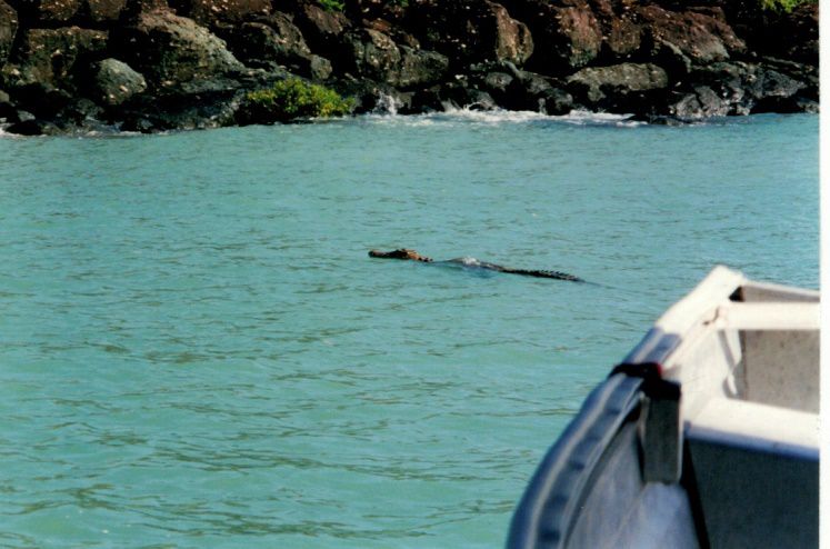
Short

Short, A.D., 2011. Kimberley beach and barrier systems: An overview. Journal of the Royal Society
  of Western Australia, 94, 19-30.

Short, A.D., 2020a. Australian Coastal Systems: Beaches, Barriers and Sediment Compartments.
  Coastal Research Library, Vol. 32, Switzerland: Springer, 1241p.

Short, A.D., 2020b. 10 days to the beach: The 1980 Broome field experiments. Journal of
  Coastal Research, Special Issue No. 101, pp. 142-145.

Short, A.D. and Woodroffe, C.D., 2009. The Coast of Australia. Melbourne: Cambridge University
  Press, 288p.

                                              224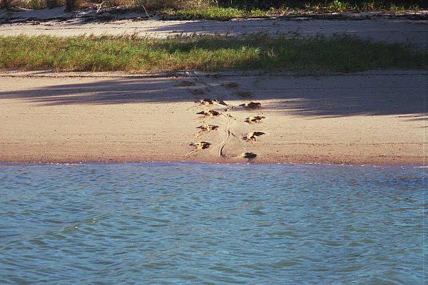
You can also read