Route Weather Resilience and Climate Change Adaptation Plans - Anglia
←
→
Page content transcription
If your browser does not render page correctly, please read the page content below
Route Weather Resilience
and Climate Change
Adaptation Plans
Anglia
Anglia Route: WRCCA plan

Contents
Director Route Asset Management statement                                                            2   .

Executive summary                                                                                    3

Introduction                                                                                         4

Anglia Route WRCCA strategy                                                                          7

Anglia Route vulnerability assessment                                                                8

Anglia Route impact assessment                                                                  15

Anglia Route WRCCA actions                                                                      26

Management and review                                                                           29

Purpose of this document
This document sets out a Weather Resilience and Climate Change Adaptation (WRCCA) plan
for Anglia Route supported by an evaluation of the resilience of rail infrastructure to historical
weather events and an awareness of potential impacts from regional climate change
projections. The resilience of rolling stock operating within the Route is not specifically
assessed.
The approach taken is consistent across all Network Rail’s Routes, and describes our current
planned mitigations, how we intend to develop the plans further, and how we are improving the
embedment of WRCCA across the business to deliver a railway fit for the future.

Network Rail                                                                                                 1
Anglia Route: WRCCA plan

Director Route Asset Management statement
                                                   The railway network has been significantly affected by severe weather conditions including
                                                   wind, snow, rainfall, lightning, heat and cold. Climate change projections suggest we will be
                                                   entering a period with increasing average and maximum daily temperatures, drier summers,
                                                   wetter winters, sea level rises and increased storminess. Increased storminess and winter
                                                   rainfall will increase the risk of flooding, earthslip and coastal storm surges, heat causes soil
                                                   desiccation and track buckling, high winds result in debris falling on to the track, and snow and
                                                   cold weather result in frozen points and blocked routes.
                                                   Anglia Route is committed to respond to the future climatic changes by increasing the
                                                   resilience of the assets during such adverse weather conditions with specific challenges
                                                   presented by the region’s geology, topography, coastal boundary and asset portfolio.
                                                   Anglia has already secured significant investment to improve the infrastructure assets in the
                                                   next five-year control period and further funding will need to be sought to improve the resilience
                                                   of the assets to future climate changes. This investment will ensure the safe operational use of
                                                   the railway and minimise train delays at a time of growing demand for rail travel in Anglia.
                                                   More effective management will also be achieved by continuing to engage with a variety
                                                   of stakeholders including flood groups, the Environment Agency and lineside neighbours.

                                                   Eliane Algaard
                                                   Director of Anglia Route Asset Management
                                                   September 2014

Flash flooding and washout at Brundall June 2014

Network Rail                                                                                                                                       2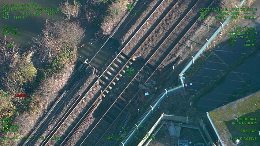
Anglia Route: WRCCA plan
Executive summary
Weather events can cause significant disruption to the operation of train services and damage Anglia Route is committed to supporting the delivery of improved weather and climate change
to rail infrastructure. A move to a warmer climate and a variance in the pattern of precipitation resilience through Route-specific objectives, including:
across the year, generally projected by the UK Climate Change Projections (UKCP09), could
increase the understanding of weather and climate change impacts on the Anglia Route,
result in changes in the frequency and intensity of extreme weather events and seasonal
having already completed a 2013 resilience study and the current WRCCA plan analysis
patterns. A detailed understanding of the vulnerability of rail assets to weather events, and
improve the knowledge of weather impacts through identification of root causes and trends
potential impacts from climate change, are therefore needed to maintain a resilient railway.
to support the identification of cost effective resilience measures
Anglia Route has developed a Weather Resilience and Climate Change Adaptation (WRCCA) predict the impacts of weather and use weather forecasting and asset monitoring to manage
plan based on assessments of weather-related vulnerabilities, identification of root causes of locations vulnerable to adverse weather
historical performance impacts and an understanding of potential future impacts from regional review data from a recent Anglia aerial topographical survey in relation to earthslip, flood and
climate change projections. coastal surge risks
install Remote Condition Monitoring (RCM) on selected assets
Using this information, Anglia Route has determined whether previous investments have
support initiatives and demonstration projects aiming to deliver network-wide resilience
mitigated weather impact risks, if actions planned during Control Period 5 (2014 to 2019) are
improvements
addressing these vulnerabilities, and where additional actions could further enhance weather
establish a sustainable lineside environment which minimises performance and safety risk
and climate change resilience.
and maintenance intervention by removal of problem vegetation and dangerous trees utilising
An analysis of Schedule 8 performance costs (the compensation payments to train and freight aerial and infrared photography captured by the RINM project
operators for network disruption) during the period 2006/07-2013/14, Figure 1, clearly shows develop and manage a Route WRCCA Plan to inform current and future Control Period
wind, adhesion and snow-related events have had the most significant impact on the Route. investment plans and workbanks
specify weather resilience and climate change adaptation in Route Requirements Documents
for renewals and new works
£10
work with lineside neighbours to establish an environment beyond the boundary that does
Millions
£9 Adhesion not negatively affect safety of the line or performance including the management of trees and
surface water run-off
£8 Cold engage with key regional stakeholders including flood risk groups and the
£7 Flood Environment Agency.
£6 Lightning Anglia Route has identified actions planned in CP5 that will increase weather and climate
change resilience including:
£5 Snow
increase forecasting capability in order to predict flooding and earthwork failures at
£4 Wind
high-risk locations;
£3 Earthslip renewals at critical earthworks, drainage and bridge scour sites
Heat engage with the Environment Agency and Local Authorities to reduce flood risk
£2 roll out strategic programmes of Remote Condition Monitoring
£1 Fog engage with the wider industry, including train operating companies to minimise delay
impacts;
£0 enhance lineside vegetation and third-party tree removal
Anglia
Anglia Route will deliver the WRCCA plan in a timely, cost efficient and safe manner.
Figure 1 Anglia Route weather attributed Schedule 8 costs 2006/07-2013/14
Network Rail 3
Anglia Route: WRCCA plan

Introduction
Weather events can be a cause of significant disruption to the railway network. Recent              In terms of the proportion of delay minutes, weather and seasonal events on average caused
prolonged periods of rainfall and extreme storm events demonstrated much of the network is          12% of all delays experienced during this eight-year period.
resilient. However asset failures such as the Dawlish sea wall, Cambrian sea defences, Botley
                                                                                                    Following the recent increase in the rate of Schedule 8 compensation payments (by around
landslip, and the widespread tree falls following the St. Jude storm, reveal the vulnerability of
                                                                                                    62%), the equivalent payments in future years would be over £80m per annum.
the rail network and the severe impact these weaknesses in resilience have on train services
and our resources. Recent examples of vulnerability in Anglia Route include the Lowestoft and       These levels of performance cost, consequential costs of repairing the rail infrastructure,
Haddiscoe washouts in December 2013, the Brantham Hall Cutting failure in March 2014, the           and wider socio-economic impacts in the UK, justify Network Rail’s enhanced investments to
uprooted trees at Purfleet in November 2013 and accelerated slope movements at Wrabness             increase weather resilience. The interdependencies within transport and infrastructure systems
in February 2014.                                                                                   similarly justifies Network Rails’ efforts to improve collaborative understanding of the wider
                                                                                                    impacts of weather-related events and our role in supporting regional and national resilience.
The impact of weather on the rail network is monitored using performance data. Schedule 8
costs; the compensation payments to train and freight operators for network disruption, are         Historical temperature records indicate that a significant relatively recent shift in climate has
used as a proxy for weather impacts due to greater granularity of root cause reporting.             occurred. The Hadley Centre Central England Temperature (HadCET) dataset is the longest
Weather-related costs can also be captured within Schedule 4 payments; compensation to              instrumented record of temperature in the world, Figure 3, and clearly shows a rising trend in
                                                                                                                                      1
train and freight operators for Network Rail’s possession of the network, and capital               temperature over the past century .
expenditure required to reinstate the asset.
Over the past eight years (2006/07 to 2013/14) the average annual Schedule 8 cost attributed
to weather for the whole network was over £50m. The data clearly includes the impacts on
train performance from the severe weather events during 2007, 2012 and 2013 from rainfall,
and 2009 and 2010 from snowfall, Figure 2.

            £100
 Millions

             £90
                                                                                     Fog
             £80
             £70                                                                     Heat
             £60                                                                     Earthslip
             £50                                                                     Wind
             £40
                                                                                     Snow
             £30
             £20                                                                     Lightning
             £10                                                                     Flood
              £0                                                                     Cold
                   2006   2007   2008   2009   2010    2011     2012    2013
                    -07    -08    -09    -10    -11     -12      -13     -14         Adhesion       Figure 3 Mean Central England temperature record

                                                                                                    1
                                                                                                     Parker, D.E., T.P. Legg, and C.K. Folland. 1992. A new daily Central England Temperature Series, 1772-1991. Int. J.
Figure 2 Whole network weather attributed Schedule 8 delay costs, 2006/07 to 2013/14                Clim., Vol 12, pp 317-342

Network Rail                                                                                                                                                                                                               4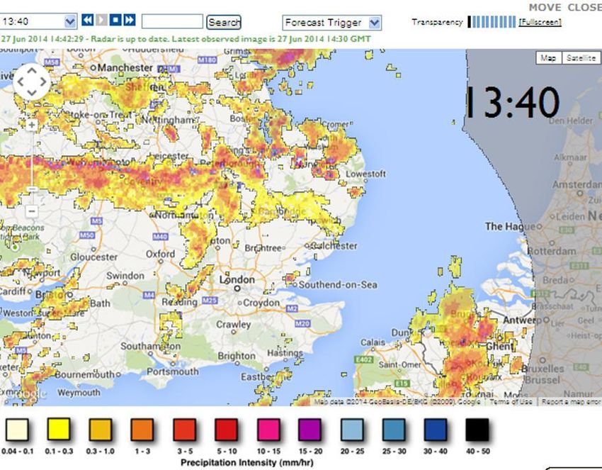
Anglia Route: WRCCA plan

Future climate change projections for the UK have been developed by the Met Office Hadley        Climate change projections include inherent uncertainties, associated with natural climate
Centre, UK Climate Projections 2009 (UKCP09). UKCP09 provides probabilistic sets of              variability, climate modelling and future emissions, and these uncertainties increase with
projections based on low, medium or high greenhouse gas emission scenarios, for climate          downscaling to local levels. However, the projections can be used by Network Rail to provide
periods of 30 years to the end of this century. For Network Rail, as a safety critical focused   a direction of where the UK climate is heading, and this Route Weather Resilience and Climate
organisation and major UK infrastructure manager, the high emissions scenario is an              Change plan uses the projections to support the prioritisation of weather resilience actions.
appropriate benchmark on which to base evaluations and decisions.
UKCP09 projects an overall shift towards warmer climates with drier summers and wetter
winters, Figure 4 and Figure 5, with regional variations.

Figure 4 Change in summer mean maximum temperature (left 2020s, middle 2050s, right              Figure 5 Change in winter mean precipitation (left 2020s, middle 2050s, right 2080s)
2080s) (© UK Climate Projections, 2009)                                                          (© UK Climate Projections, 2009)
                                                                                                 To ensure weather resilience and climate change adaptation is approached consistently across
                                                                                                 Network Rail, an iterative framework provides key management stages: set strategy, assess
                                                                                                 vulnerability and impact, identify actions, and review, Figure 6. This framework has been
                                                                                                 applied to develop the Anglia Route WRCCA plan.

Network Rail                                                                                                                                                                                 5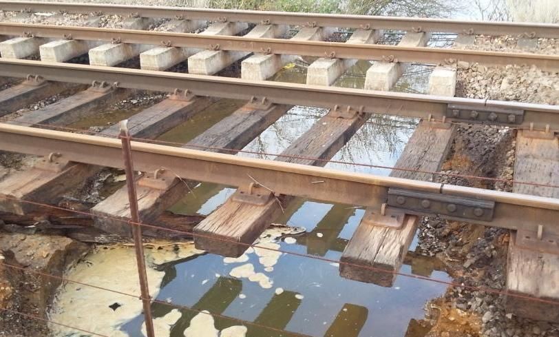
Anglia Route: WRCCA plan
Strategy
and policy
Adaptation Management Vulnerability
actions and review assessment
Impact
assessment
Figure 6 Weather resilience and climate change adaptation framework
Network Rail weather resilience and climate change adaptation actions will include a range
of measures appropriate to the strength of evidence and level of risk:
soft – changes to processes, standards and specifications, increasing knowledge and
skill base
hard – engineered solutions to increase resilience; e.g. raising of sea walls and increasing
drainage capacity
‘do nothing/minimum’ – the option to ‘do nothing’ or ‘do minimum’ should be evaluated
‘no regrets’ – measures that increase the resilience of the assets to current and
future impacts
precautionary – investment into adaptation measures today in anticipation of risk in the future
managed adaptive – a staged approach incorporating uncertainties in future risk and current
investment funds, allowing assets to be retrofitted cost-effectively in the future.
The following sections provide findings from the Anglia Route vulnerability and impact
assessments, and details of the actions, both completed and planned for Control Period 5
(CP5), that will increase weather and climate change resilience.
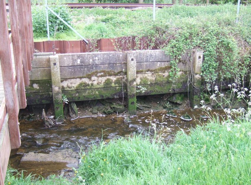
Track flooding at Surlingham
Network Rail 6
Anglia Route: WRCCA plan
Anglia Route WRCCA strategy
The Network Rail Sustainable Development Strategy outlines corporate weather resilience work with lineside neighbours to establish an environment beyond the boundary that does
and climate change adaptation objectives, and commits the business to: not negatively affect safety of the line or performance including the management of trees
and surface water run-off
understand our current weather resilience, and seek to optimise resilience and enhance
engage with key regional stakeholders including flood risk groups, Environment Agency
adaptation capability
and Statutory Undertakers
develop a thorough understanding of the potential impacts of climate change in terms
undertake quantitative studies to understand the tidal and fluvial flood risk to infrastructure
of infrastructure performance, safety risks and costs
at sites where flood risk is known
embed climate change adaptation within our asset policies and investment decisions
undertake works on a risk basis to improve track and track support assets in areas
communicate the role that the rail network plays in supporting weather and climate
where heat speeds have been imposed historically or where they are predicted to occur
resilience across Great Britain, and support efforts to increase national resilience.
in the future.
These objectives will support the long-term management of a weather resilient railway develop a longer-term WRCCA plan to include heat resilience of swing bridges, additional
and are fundamental steps towards achieving Network Rail’s sustainable development drainage capacity resulting from increased storm intensities and increased run-off from
vision of a railway fit for the future. adjacent catchments, burst water mains and highway approaches to level crossings
review Route weather preparedness plans and procedures in relation to climate change
Anglia Route strategy
projections
Anglia Route is committed to supporting the delivery of this strategy through Route-specific
install Remote Condition Monitoring (RCM) on selected assets
weather resilience and climate change adaptation objectives:
combine RCM data with Met Office, Hydrocast and Environment Agency ‘broader’ data
increase the understanding of weather and climate change impacts on the Anglia Route, and intelligence
having already completed the 2013 Willis study and current WRCCA plan analysis into use triggers and action levels to apply operational restrictions based on asset condition
weather impacts and local weather observations.
improve the knowledge of weather impacts through identification of root causes and trends
Through these objectives, Network Rail’s corporate commitments are applied in the context
to support the identification of cost effective resilience measures
of Anglia Route, supported by the opportunities to deal locally with challenges of a changing
predict the impacts of weather and use weather forecasting and asset monitoring to
regional climate. Meeting these objectives will contribute to the long-term resilience and
manage locations vulnerable to adverse weather
sustainability of Anglia Route and the whole railway network.
review topographical data from recent Anglia aerial Light Detection and Ranging (LiDAR)
survey from the Rail Infrastructure Network Model (RINM) project in relation to earthslip,
flood and coastal surge risks
develop and manage a Route WRCCA Plan to inform current and future Control Period
investment plans and workbanks
prepare additional site specific weather-related schemes identified following the St Jude’s
Storm high winds event of 27 and 28 October 2013, the storm surge event on 5 and 6
December 2013 and the prolonged rainfall experienced in January and February 2014
specify weather resilience and climate change adaptation in Route Requirements
Documents for renewals and new works
support initiatives and demonstration projects aiming to deliver network-wide resilience
improvements
establish a sustainable lineside environment which minimises performance and safety risk
and maintenance intervention by removal of problem vegetation and dangerous trees
utilising aerial and infrared photography captured by the RINM project
Network Rail 7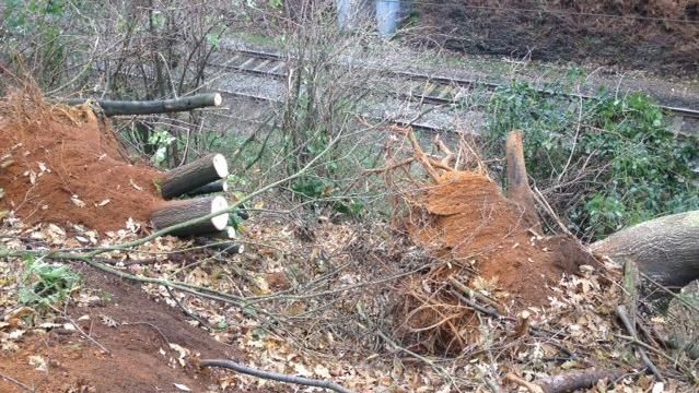
Anglia Route: WRCCA plan
Anglia Route vulnerability assessment
This section provides the details of the general vulnerability of the rail network in Great Britain
and Anglia Route’s specific vulnerabilities to weather impacts, and regional climate change
projections.
Network-wide weather vulnerability
The challenge for Network Rail is to manage a complex and extensive portfolio of assets, with
variations in geographic location, age, deterioration rates and vulnerability to weather impacts.
Continual analysis of the vulnerability of rail assets to weather, and identification of trends and
characteristics of weather-triggered failures, improves our knowledge of the resilience of the
rail network. An understanding of current weather impacts is an essential platform to implement
cost-effective investments to adapt the network to future changes in climate.
The whole rail network is sensitive and exposed in some way to many primary climate drivers
and secondary impacts, including:
temperature
rainfall
wind gusts Figure 7 Example of asset failure and weather analysis
flooding
landslips Managing operational response to weather vulnerability
soil moisture Network Rail manages risks from weather-related impacts through a range of asset
sea level rise management tools, operational response standards and alert systems. Higher risk assets
coastal erosion. are prioritised for investment within asset policies and proactively managed through
risk-based maintenance.
Network Rail has moved from subjective and expert review-based knowledge of weather
and climate change risks to more detailed internal analysis of asset failure and weather data Defining ‘normal’, ‘adverse’ and ‘extreme’ weather conditions is fundamental to ensuring
to understand thresholds at which failure rates significantly change. Figure 7provides an effective coordination across the rail industry. Network Rail and the National Task Force
illustrative example of the analysis identifying assets with higher sensitivity to weather impacts. (a senior rail cross-industry representative group) are currently reviewing weather thresholds
The horizontal lines are thresholds where there is ‘no significant’ (green), ‘significant’ (amber) and definitions to improve the Extreme Weather Action Team (EWAT) process which manages
or ‘very significant’ change in incident rates (red). This deeper dive analysis is critical to train services during extreme weather alerts.
understanding the resilience of operational assets today and potentially in future climates. Control rooms monitor and respond to real-time weather alerts through a range of action plans.
From this analysis it has been established that high temperatures have wider impacts across Operational response to the risks posed by weather events includes: temporary speed
assets, earthworks are the predominant asset sensitive to rainfall and overhead line equipment restrictions (TSRs), deployment of staff to monitor the asset at risk, proactive management
(OLE) to wind gusts. of the asset; i.e. use of ice maiden trains to remove ice from OLE or protection of assets from
flood water, and in some cases where the risk dictates, full closure of the line. Increasing the
Rail asset and weather impact relationships are complex, as demonstrated in the case of OLE resilience of the infrastructure reduces the need for operational response however the range of
where many wind-related failures are a result of vegetation incursion and not direct wind gusts weather events experienced today, potential changes in the future, and the prohibitive scale of
as the primary impact. Therefore any analysis of rail assets and weather vulnerability requires investments required to mitigate all weather risks, means that operational response will always
deeper understanding of root causes to identify cost effective resilience actions. be a critical process for Routes to manage safety risks.
Network Rail 8Anglia Route: WRCCA plan
Network Rail seeks continuous improvement of weather-based decision support tools, Longer-term flood risk management of rail assets is provided through geographic information
including flood, temperature, wind speed and rainfall alerts. A trial aiming to significantly system (GIS) decision support tools including flood datasets, such as Network Rail’s Washout
improve real-time weather forecasting has installed approximately 100 weather stations on the and Earthflow Risk Mapping tool (WERM). Transformative asset information programmes are
Scotland rail network. The pilot study is currently being evaluated to support a potential wider currently aiming to improve weather-related hazard mapping in decision support tools.
roll-out of this level of weather service and so existing radar feeds will continue to be used for
real time weather monitoring in Anglia, Figure 8. Improving our network wide resilience
A Weather Resilience and Climate Change (WRCC) programme is at the centre of Network
Rail’s delivery plans. Its importance is underlined by the fact that it is one of the Company’s top
15 business change projects. The programme was first identified in April 2013, but its priority
and profile were heightened as a result of the extreme weather that was experienced between
October 2013 and March 2014. The programme board and stakeholders include
representatives from across the rail industry.
The WRCC programme is founded on a bow tie risk assessment, Figure 9, of weather-related
disruption – this risk assessment methodology is used widely across Network Rail. The bow tie
assessment provides a detailed understanding of the adequacy of the controls that are in place
to reduce the causes of disruption and consequences and highlights those controls that may
need to be enhanced.
Figure 8 Anglia Route real-time weather monitor
For the management of operational flooding risk, Network Rail receives alerts through our
Flood Warning Database based on warnings issued by the Environment Agency and the risk
is translated to rail assets. In locations where no national flood warnings are available, Network Figure 9 Bow tie risk assessment
Rail can arrange to receive alerts from bespoke river level monitoring equipment.
Network Rail 9Anglia Route: WRCCA plan
The programme consists of six sub-programmes and their 23 constituent projects; these are The WRCC programme is currently supporting the delivery of:
described in Figure 10 below. Although the bulk of the outcomes that are currently defined
an enhanced vegetation management project: £10m of accelerated funding to address high-
expect to be delivered within the next 18 months, the programme is expected to extend
risk trees and mitigate the impact of both extreme winds and adhesion issues
throughout CP5.
points enhancements: installation of up to 7,000 points heat insulation and covers in support
It is important to emphasise the national-level programme supplements the work Routes of Key Route Strategy
are completing under their CP5 business plans. forensic investigation of earthworks failures in 2012/13 and 2013/14: The 261 failures that
occurred during this two-year period have been investigated with deep dive analysis being
WWRCC Sub-Programmes undertaken on 89 of them
earthworks remote condition monitoring pilot: involving 250 high-risk sites across four Routes
(Scotland, LNE, Wessex and Western) starting in December 2014
Infrastructure Cross-industry Earthworks improved drainage management: mobile works tools and drainage competency
1 2 3
Resilience Resilience Integrity
improvements by December 2014
1. Year 1 Enhanced vegetation 8. Property portfolio 12. Improved Earthworks agreed weather thresholds and definitions
management strategy 9. Fleet Knowledge
2. Sustainable vegetation 10. Timetabling-flexibility and 13. Improved Drainage an enhanced Extreme Weather Action Team process: This will be reviewed and the
strategy contingency planning Knowledge and Management improved processes implemented into the first Route by end November 2014
3. Identifying Highest Risk 11. Providing advice and 14. Improved Earthworks
aerial surveys of infrastructure using the Light Detecting and Ranging (LIDAR) technique; this
assets Enhanced resilience communicating with Monitoring
to effects of: customers 15. Improved Earthworks will be complete by December 2014
4. Flooding Management enhanced weather forecast service which will be in use from April 2015
5. Costal surge
6. Snow, Ice and extreme
temperatures Route weather vulnerability
7. High winds
Anglia Route’s vulnerability to weather impacts and climate change is generally related to the
geology and topography of the region with region-specific features including the coastal fringes
National Weather Climate Change Information
4
Event Response
5
Adaptation
6
Exploitation
and swing bridges on the Norfolk Broads.
16. Weather Definitions and 20. Route Climate Change 22. Delivering supplementary The southern parts of Anglia which are approximately south of a line from London to Ipswich
Thresholds Adaptation Plans information are built on London Clay or using London Clay derived fill. These are moisture sensitive
17. Weather Event Response 21. Tomorrow’s Railway & 23. Delivering Weather Resilience
18. Weather Information and Climate Change Adaptation Intelligence materials, prone both to conventional failure when saturated in winter but also to desiccation
Decision Support systems project failure where track quality is very difficult to maintain in dry summer and autumn conditions.
19. Strategic resource
management
This affects several lines but is most pronounced on the FSS2 between West Horndon and
Lower Dunton in Essex. The fenland peats in the Ely area and other local peat bogs are also
Figure 10 The constituent components of Network Rail’s WRCC programme notable shrinkage and swelling problem areas. Significant works are therefore required to
improve resilience of such London Clay and peat-related assets.
Glacial sands and Glacial Till derived sand fills in the central and northern parts of the Anglia
Route are vulnerable to washouts due to concentrations of water from surface run-off or
intense storms. Cutting slopes where perched water tables exists in sands overlying clays will
also be more vulnerable to earthslips with increased groundwater levels
Low-lying areas on poorly draining soils such as the Fens and the Norfolk Broads are
vulnerable to flooding with embankment settlements and rising groundwater levels making
drainage outfalling more difficult. Low-lying coastal and estuary areas such as Lowestoft, the
Stour estuary and the Alluvial flats adjacent to the River Thames are also vulnerable to sea
level rises, scour and storm surge events. The low-lying exposed areas and shallow
earthworks also make the assets more vulnerable to wind damage, particularly OLE assets.
Network Rail 10Anglia Route: WRCCA plan
Figure 11 Storm surge washout at Oulton Broad Figure 13 Tree-related issues
The Anglia Route commitment to better understanding of weather and climate change impacts
on network operations and key assets is shown by the March 2013 Natural Hazards Resilience
Study undertaken by risk and insurance advisors Willis Limited. This study used insurance
market recognised quantitative models to assess the impact that natural hazard events could
have on assets in terms of property damage and anticipated downtime impact. The key output
from this study was a database ranking individual asset vulnerability to each of the perils
modelled. The study concluded that windstorms produced the highest modelled damage in
Anglia although the study was limited to considering only flood, wind and coastal surge perils.
The Willis study also undertook a weather extremes and climate variations analysis that noted
little variation in temperature or wind speed extremes across Anglia but a more marked future
pattern of increased rainfall in the northern and western parts of Anglia.
Figure 12 Earthslip at Acton Wells embankment
Network Rail 11Anglia Route: WRCCA plan
Future climate change vulnerability Mean daily maximum temperature change
The relationship between weather events and climate is complex; therefore it is The mean daily maximum temperature in the East of England, Figure 15, is projected to
understandable that climate change projections do not forecast future weather events. increase throughout the year, with greater increases expected in the summer months through
However, Network Rail can use the climate projections to understand potential risks and the century. Average maximum daily temperature in July is expected to increase by 2.9°C,
make informed strategic decisions to increase future weather resilience. reaching 24°C by the 2050s, and by 4.7°C, reaching 25.8°C by the 2080s. Average maximum
daily temperature in January is expected to increase by 2.2°C, reaching 8.4°C by the 2050s,
The UK Climate Change Projections (UKCP09) provides regional climate change projections
and by 3.2°C, reaching 9.4°C by the 2080s.
across 13 administrative regions in Great Britain, Figure 14. The East of England projections
provide Anglia Route with indications of future climate change. 6
5
2080s
Temperature Change (°C)
4 2070s
2060s
3
2050s
2 2040s
2030s
1
2020s
0
Jan Feb Mar Apr May Jun Jul Aug Sep Oct Nov Dec
Figure 15 East of England, mean max temperature change (50th percentile)
Figure 14 UKCP09 administrative regions
The following derived charts from UKCP09 data show the projected changes in temperature
and precipitation for the high emissions scenario, 50th percentile (10th and 90th percentile data
has been obtained). The projected changes are shown for future climate periods up to the
2080s (2070-2099) and are relative to the baseline climate of 1970s (1961-1990).
Network Rail 12Anglia Route: WRCCA plan
Mean daily minimum temperature change Mean daily precipitation
The mean daily minimum temperature in the East of England is also projected to increase The mean daily precipitation in the East of England is projected to significantly increase in
throughout the year, Figure 16. Average minimum daily temperatures in July are projected to winter months and decrease in summer months, Figure 17. The greatest increase is expected
increase by 2.7°C, reaching 14.5°C by 2050s, and by 4.4°C reaching 16.2°C by the 2080s. to occur in February, projected to be 22 per cent, reaching 1.6mm per day by the 2050s, and
Average minimum daily temperature in January is projected to increase by 2.9°C, reaching 37 per cent, reaching 1.8mm per day by the 2080s. The greatest decrease in precipitation is
3.9°C by 2050s, and by 4.2°C, reaching 5.2°C by 2080s. likely to occur in August. Mean daily precipitation is projected to decrease by 18 per cent by
the 2050s, reducing to 1.3mm per day, and by 29 per cent, reducing to 1.1mm per day by
5 the 2080s.
4.5
40
4 2080s
Temperature Change (°C)
3.5 30
2070s
Daily Precipitation Change (%)
2080s
3 20
2060s 2070s
2.5
2050s 10 2060s
2
2040s 0 2050s
1.5
2030s Jan Feb Mar Apr May Jun Jul Aug Sep Oct Nov Dec
1 -10 2040s
0.5 2020s 2030s
-20
0 2020s
Jan Feb Mar Apr May Jun Jul Aug Sep Oct Nov Dec -30
Figure 16 East of England, mean min temperature change (50th percentile) -40
Figure 17 East of England, mean daily precipitation change (50th percentile)
Network Rail 13Anglia Route: WRCCA plan Sea level rise Sea level rise for the Anglia Route coastal and estuarine assets can be represented by the projections for Suffolk, near Lowestoft. For the high emissions scenario, the projections for the 50th percentile for 2050 is 0.268m and 0.581m by the end of century (the rise is unlikely to be higher than 0.411m and 0.904m respectively), Figure 18. Figure 18 UKCP09 sea level rise projections for Lowestoft area The understanding of the vulnerability of Anglia Route rail assets to current weather and potential risks from future climate change is an important stage in developing WRCCA actions. Network Rail 14
Anglia Route: WRCCA plan
Anglia Route impact assessment
This section provides the findings from the Anglia Route weather impact assessment, including on the Route. The risk of lightning strikes is also likely to be affected by increased storminess.
annual performance impacts and identification of higher impact locations on the Route. With the low-lying topography of Anglia, increased winter rainfall, storminess and sea level rise,
the risks of flooding and storm surges will increase.
Performance impacts
A combination of the assessment of historical weather impacts on the Anglia Route and
The impact of weather on the rail network can be monitored within rail performance data.
regional climate change vulnerability from UKCP09 can be used to prioritise resilience actions.
Schedule 8 costs, the compensation payments to train and freight operators for network
disruption, are used as a proxy for weather impacts due to greater granularity of root cause Table 1Prioritisation of weather-related impacts on Anglia Route
reporting. Weather-related impact Schedule 8 costs1 Projected future impacts Prioritisation
Schedule 8 costs for the past eight financial years for Anglia have been analysed, Figure 19, to Wind £1.08m Wind changes difficult to project however High
provide an assessment of weather impacts. generally projected to increase
Adhesion £0.44m Complex relationship between adhesion Medium
‘flooding’ costs include delays due to a range of fluvial, pluvial, groundwater and tidal flooding issues and future climate change.
of assets.
Snow £0.44m 2.9°C increase in January mean daily Medium
‘earthslip’ delays have been included due to internal analysis indicating primary triggers
minimum temperature2
of earthworks failures are weather-related.
Lightning £0.33m Storm changes difficult to project Medium
‘heat’ and ‘wind’ include direct impacts on assets and impacts on delay due to speed
however generally projected to increase
restrictions implemented as part of Network Rail’s operational response during weather
events. Cold £0.21m 2.9°C increase in January mean daily Low
minimum temperature2
Earthslip £0.13m 22 per cent increase in February mean High
£10
daily precipitation1
Millions
£9 Adhesion Heat £0.11m 2.9°C increase in July mean daily Medium
£8 Cold maximum temperature2
£7 Flood Flooding £0.04m 22 per cent increase in February mean High
£6 Lightning daily precipitation2
£5 Snow Sea level rise £0.02m 0.27m increase in sea level rise3 Medium
£4 Wind
Fog £6k Complex relationship, however research Low
£3 Earthslip suggests fog events will decrease
£2 Heat
1 Annual average 2006/07 to 2013/14,
£1 Fog 2 UKCP09 projection, 2050s High emissions scenario, 50th percentile, against 1970s baseline
3 UKCP09 projection, 2050s High emissions scenario, 50th percentile, against 1990 baseline
£0
Anglia It is also worth noting the Schedule 8 cost per delay minute in CP5 will be on average
Figure 19 Anglia Route weather attributed Schedule 8 costs 2006/07-2013/14 60 per cent higher, further reinforcing the importance of effective WRCCA actions.
The analysis shows that wind has been the most significant weather impact for the Route,
with total Schedule 8 costs over £8m during the period 2006/07-2013/14.
Climate modelling cannot provide strong projections for future changes to wind speeds, though
increased storminess is generally projected and may increase the risk of wind-related incidents
Network Rail 15Anglia Route: WRCCA plan
Identification of higher risk locations As average temperatures increase the season available to undertake advance maintenance
A geographic information system (GIS) based decision support tool, METEX, has been will reduce as the season where critical rail temperature (CRT) is possible will lengthen. The
developed to analyse gridded observed weather data and rail data, including the past eight number of days where the CRTs are exceeded will increase which will require a corresponding
years of delays attributed to weather. increase in speed restrictions to manage the safety risk of a track buckle to be imposed on a
greater number of days per year over a longer summer season, and potentially for longer
Over recent years our network has experienced some of the most extreme weather on record
periods on those days when the CRT is reached. This increase will have to be mitigated by
and weaknesses in existing assets will be captured in performance impacts. Climate change is
concentrating advance track works that disturb the track formation into an ever smaller window
projected to impact the UK with more intense and frequent extreme weather events, so taking
during the winter. This will be a significant challenge for maintenance depots, who are unlikely
actions on our current weaknesses, and proactively managing future risks are important steps
to have access to any additional maintenance shifts in winter. This maintenance cannot be
to increasing our future resilience.
squeezed into an ever shorter season without radical efficiency improvements or changes in
Higher-risk locations have been identified by assessing METEX outputs for high-frequency/ methodology or a larger workforce with more access to the track in the winter period. The
high-cost sites across the whole Route, and detailed assessment of key sections of the rail Anglia CRT site register will continue to be the subject of an ongoing review including the
network. These locations have been assessed to determine: processes when CRT is exceeded.
validity of the delay attribution to a weather impact It is possible that track standards for rail stress management may be modified as the climate
root cause of the delay warms to increase track maintainability. One mitigation would be to reduce sleeper spacing
resilience actions that have been undertaken but this would require a significant capital investment. Heavier sleepers also reduce the risk
resilience actions that are currently planned and areas with light sleepers (e.g. softwood) will need to be replaced with concrete sleepers.
identification and prioritisation of additional resilience actions. Other options to increase permissible rail stress include re-profiling areas with inadequate
ballast shoulders and/or lateral resistance sleeper end support to prevent the rail slewing in
In addition, Routes have identified potential future risks and resilience actions based on climate
towards the inside of curves in winter and to prevent slewing off the outside of curves in
change projections and Route knowledge.
summer. More radical options may be to convert to a slab track system in high-risk areas or the
development of engineering solutions to mitigate the increased lateral forces due to the thermal
Heat impact assessment
expansion and contraction of the running rails. Additionally ballast gluing can be explored in
Based on 2006/07 to 2013/14 data, heat-related events account for total 3,960 delay minutes
high-risk areas.
per year on average, costing £0.109m per year in Schedule 8 costs. This is 3.7 per cent of
weather-related delay minutes. The common complication with most options to increase the track’s resilience to stresses
induced by temperature variation is a need for a more robust track support system including
Track asset
more space on bridge decks and embankments for a more substantial formation. High-risk
The impact of high temperature is often a problem in the management of the track asset
areas include areas where there are multiple track deficiencies (wet beds, inadequate ballast
although on some sites the overhead line (OLE) performance is affected before the track.
shoulder) or specific assets vulnerable to heat, including Switches and Crossings (S&C),
Track maintenance teams put significant resource into managing the track asset in a way that
notably switch diamonds. Anglia’s historical track maintenance practices have resulted in a
limits the number and length of heat speeds required to manage safety which are largely
higher track alignment than was originally designed to be accommodated leading to ballast
successful resulting in the current impact being relatively small. Capital investment in the track
loading to many underline bridge parapets and spandrels and to ballast retention problems on
asset is also partly targeted to remove assets that perform poorly in high temperatures
numerous embankments as track raising reduces the crest width. The problem could be
including removing the remaining jointed track and works programmed to minimise heat-related
managed by track lowering or significant engineering to increase the width of embankments
formation disturbance to minimise the risk of a heat-related speed restriction. Jointed rail will
and to retain ballast in an engineered way on underline bridges although track lowering would
remain in sidings, depots, passing loops and freight only lines with low usage or low speed
be prohibitively expensive. Over-ballasting in cuttings is less difficult to manage but has
limits until it is life expired.
resulted in drainage becoming more difficult to maintain as cess ditches are filled and catchpits
are buried.
Network Rail 16Anglia Route: WRCCA plan
There are two potential non-structural heat mitigations for track. The first is to use Remote Staff workplaces must also be modified or replaced to deal with increasing temperatures. Staff,
Condition Monitoring (RCM) to detect either rail temperature or rail stress at regular intervals particularly those undertaking safety critical roles such as signallers and electrical control room
and this data allows automated speed restrictions to be applied only where rail temperature staff share their work space with large electrical and electronic installations so must be
or stress is actually causing a risk to safety. This would remove the need to apply the current provided with sufficient ventilation and air conditioning to maintain a safe working environment.
blanket controls which use a very conservative estimate of rail temperature based on a formula
Electrical equipment housed in both location cabinets and buildings will also overheat if
and a temperature forecast. This may also reduce or remove the need to place special
ventilation or air conditioning is insufficient. This may be a greater problem if tree cover, which
restrictions in place following engineering works. The second mitigation is to paint the rails.
currently shades many such installations, is removed. Accelerated programmes for cabinet and
Good results have been achieved by hand painting short lengths of rail in areas of high risk
building ventilation therefore need to be considered.
of significant rates of thermal expansion in direct sunlight, this work is currently carried out
by hand and with little control of application methodology or paint specification. There is scope
Soil desiccation
to mechanise this process and to closely control specification which could lead to much more
Hotter summers are also expected to be drier which poses a risk for embankments constructed
effective rail temperature, reduced need to reapply the coating, and the potential to treat the
of moisture sensitive clays or founded on clay soils which shrink as they dry and expand when
entire network. The use of shading systems can also be explored.
they are wetted, Figure 20. These desiccation effects also impact on peat foundation soils,
Track is more likely to be affected by heat speeds if it is in direct sunlight. Works to significantly notably the problems experienced on the Fens and at Thrandeston bog. Embankments and
reduce the amount of tree cover to mitigate against the risk of increasing wind, to reduce foundation soils of these types dominate on several lines within Anglia Route most notably the
adhesion problems and to reduce soil desiccation risks may significantly increase the EMP peats north of Ely and the FSS2 London Clay east of West Horndon. In future drier
proportion of the track asset that is unshaded. The benefits of de-vegetation are expected summers, these embankments will shrink more, resulting in significant track quality problems
to outweigh those of reduced shading although such de-vegetation may need to be and increased need for re-ballasting and tamping. The interventions required to repair the
complemented by further track resilience such as rail painting or the use of sunscreens in high- damage to the track caused by embankment shrinkage require speed restrictions to be
risk areas such as areas of low ballast depth. imposed until they have consolidated, particularly in hot conditions, thus increasing the time it
impacts on the track quality performance.
Vegetation
Shorter periods of temperature close to freezing will increase the active growing season for
many plant species and when combined with wetter winters will lead to more vigorous growth
in the spring. Vegetation management will become more expensive as a result. Plant species
may generally migrate north, this will result in existing plants, such as some broad leaved trees
becoming stressed by drier summers and becoming dangerous, these species will have to be
removed from the network where they pose a risk, this is likely to be a significant problem with
adjacent third-party trees over which network rail has less control. New species which are likely
to be more vigorous than those they displace will require new management practices.
During drier summers the frequency and severity of lineside fires can be expected to increase,
this can largely be mitigated by managing the lineside environment to be largely free of
combustible materials, this will require a change in management practice as we currently leave
most cut vegetation on the lineside either as cut material or as chipped material, both burn well
when dry.
Buildings
As passenger densities and temperatures increase, passenger comfort must be monitored and
alterations made to buildings to improve ventilation and cooling as required including
reinvigoration of the solar powered air vent (SPAV) programme. Passengers may also become
more agitated when overheated and in these conditions accidents are more likely.
Figure 20 Desiccation/shrinkage risk
Network Rail 17Anglia Route: WRCCA plan
Ongoing re-ballasting interventions to manage soil desiccation induced poor track geometry Frozen points are a key issue in cold weather and therefore an accelerated programme of
issues will generally raise the track and so reduce the crest width which will eventually require points heater installations of those points without heaters would help to reduce the short-term
the introduction of cess support and may also require additional works to manage the risks. Similarly ensuring the thermal insulation of any points heaters not included in the CP4
associated reduced OLE clearances. programme should also be revisited. The Liverpool Street canopy area points are also still
vulnerable to ice issues as a result of snow and ice falling off trains with procedures being
Structures reviewed to identify how resources can be effectively deployed in the Liverpool Street throat
The thermal expansion of structures in hotter summers will also need to be managed, notably area to manage this risk.
for the swing bridges which risk being unable to open if sufficient heat expansion occurs. This
The risk of significant delays due to cold and snow may reduce with increasing climate change
will require a review of how heat resilience can be improved
temperatures and moderate investments in better procedures and relatively short-term
Replacement of the remaining fixed tension OLE wire systems will also be required to achieve investments such as more de-icing train capacity may provide more cost effective actions.
o o
the currently required temperature tolerance range of -15 C to +35 C. A programme is under
Snow is infrequent in much of Anglia Route and the very significant delay minutes are due
way to achieve this by 2018, notably for the section of fixed tension OLE between London and
to the wide spread nature of this problem when it does occur and the remote locations on the
Chelmsford. The majority of the known heat sites have already had interventions although the
Anglia network. In particular snow will stop trains from running if it prevents contact with the
future heat-related workstreams include the following:
DC conductor rails typically found in the London area. Although the number of cold and snow
more frequent de-vegetation fall events is likely to fall in future years, and the season where there is a snow risk is likely to
more regular tamping shorten, it is possible that snowfall may increase in intensity and in the short term is likely to
increased use of cess support remain a significant cause of weather-related delay.
review of current adverse weather plans and Critical Rail Temperature database
The majority of the known sites have already had interventions although future cold and snow-
shoulder ballast/plate support/lightweight sleepers/rail painting for CRT stress
related workstreams include the following:
accelerated cabinet ventilation programme
development of a building ventilation programme accelerated programme of points heater installations
review of heat resilience of swing bridges (e.g. sprinkler systems, replacement bridges) review of current weather procedures and forecasting
remote monitoring of rail temperature review need for increased MPV capacity for snow clearance
painting rails white in critical locations (review and extend database of sites) assess benefits of heating for 3rd rail (review Kent experience)
o o
removal of fixed tension OLE to achieve temperature range -15 C to +35 C. review of drainage on structures affected by icicles
check de-icing train has sufficient availability
Cold and snow impact assessment ensure CP4 thermal insulation of points heating completed
Based on 2006/7 to 2013/14 data, cold-related delays totalled 6,253 minutes per year on staff deployment strategy for points at Liverpool Street throat area (for ice falling off trains).
average, costing £0.211m per year in Schedule 8 costs. This is 5.9 per cent of weather-related
delay minutes. Snow-related delays totalled 15,154 minutes per year on average, costing
£0.437m per year in Schedule 8 costs. This is 14.3 per cent of weather-related delay minutes.
Cold weather without snow is largely managed as the management of snow.
The primary mitigation for snow and cold is good forecasting allowing robust emergency
timetables to be implemented and the targeted use of MPVs to de-ice key routes. An increased
robustness in these capabilities could improve preparation for well-forecasted cold weather and
speed up recovery following ice or snow fall.
Icicles from bridges shorting the OLE wires and iced DC conductor rails in the London area
cause the greatest disturbance to service. Further work is therefore warranted at reviewing the
drainage provisions for bridges affected by icicles and in assessing the benefits of heating the
DC conductor rails with the latter building on experience gained in Kent.
Network Rail 18Anglia Route: WRCCA plan
Flooding and sea level rise impact assessment
Based on 2006/07 to 2013/14 data, inland and coastal flooding-related delays totalled 3,939
minutes per year on average, costing £0.064m per year in Schedule 8 costs, of which
approximately one third is coastal storm surge-related and two thirds are surface water run-off
issues. This represents 3.7 per cent of weather-related delay minutes in Anglia.
Flooding
The climate is forecast to become warmer and wetter in the winter with an increasing number
of storms of increasing ferocity which will be a challenge to manage. Drainage assets
throughout the Route require investment and geotechnical assets are sensitive to intense
storms and the impacts of very heavy rainfall. Numerous landslips occurred nationally in the
winter of 2012/2013 and also the very wet winter of 2013/2014 although the Anglian region
was much less severely affected than further south and west. Speed restrictions were,
however, imposed at some locations in Anglia at these times in order to mitigate against the
risk of flooding damaging bridges or washing out the track at locations where the flood risk was
high, notably during the Lowestoft to Haddiscoe storm surge washouts in 2007 and 2013.
Many other areas are also prone to surface flooding including the previously noted recent flash
flood at Surlingham and sites such as these would benefit from having remote monitoring
cameras to provide instant assessments of flood risks.
Figure 22 Scour damage at Melton
Parts of the Anglia infrastructure are built along the margins of floodplains and other flat poorly
drained areas such as the Norfolk Broads, the Fens and the northern bank of the Thames
Estuary. Modern flood risk assessments were not carried out when the railways were built, and
floodplains have generally accreted in the intervening 100 plus years. Increasing urbanisation
and changing farming practices have also increased run-off rates. These problems all combine
to increase the vulnerability of the network to flooding, and this will worsen as winter storms
intensify. Third-party run-off is a particular problem at highway level crossing sites and there is
a need to manage these in partnership with local authority highway departments with reviews
of the capacity of the system, floodpaths and the benefits of locally raising signalling cabinets.
A programme of bridge scour protection has been undertaken in Anglia in CP4 with five of the
most critical scour sites mitigated in CP4 and a further two already programmed for CP5 which
will significantly reduce the risk of bridge failure due to scour or surcharging local to the bridge
footings. A further 13 at-risk structures will be remediated in CP5.
Figure 21 Storm surge damage at Oulton Broad
Network Rail 19Anglia Route: WRCCA plan
Increasingly frequent and intense storms will overwhelm the existing track drainage networks
Sites where flooding and storm surge interventions have been undertaken in CP4 include:
which have suffered from under investment in previous decades. This will lead to increasingly
frequent traffic disruption and accelerated degradation of assets that depend on good Highbury and Islington to Dalston sewer
drainage, particularly geotechnical assets and the track formation. The current drainage asset Fordley Hall drainage
currently requires interventions in parts of the route and a robust long-term maintenance Woodgrange Drive Southend
regime to be implemented and funded. In the coming decades the drainage assets should be Lindsay Close BrentWood
assessed and where capacity is insufficient for predicted climatic conditions improvements Gunnersbury Junction
should be implemented. In future years it is likely that some locations, particularly in the coastal
In CP5, planned interventions include sites located at:
floodplain will no longer function as effective gravity drainage systems unless significantly
greater system storage is constructed and if this is not practical pumped drainage will become Wrabness (Phase 1)
increasingly necessary. Bishops Stortford flooding
West Horndon to Dunton
Sea level rise
Over time ground levels in areas discharging into tidal rivers, coastal marsh and the floodplain
Sea level increase will not have a day-to-day impact in the short to medium term but in the
of lowland river systems have increased as successive floods or tides have deposited silt. The
longer term the impact will increase. Minor coastal storms will have an ever-greater impact
rail infrastructure is a fixed point in this rising landscape and the maintenance of culverts, and
and over time the proportion of the tidal cycle that coastal gravity drainage systems are able
associated approach ditches, which discharge on to neighbouring land, needs to manage
to discharge over will reduce. In the short term this will result in more tide locking and flooding
these changes. The impact of these changes is difficult to quantify but the height of the railway
only if rain falls over the high tide period, however in the longer term there is a risk available
above the floodplain will reduce with time increasing the chance of track flooding and
drainage capacity will be utilised to discharge ‘normal’ flows leaving no capacity to deal with
infrastructure damage which is exacerbated by particular difficulties in maintaining drainage
storm water. When combined with the increased storminess and more intense rainfall the
features. A secondary important impact is that with reducing drainage effectiveness
number of occasions when the capacity of surface water drainage systems in the coastal zone
embankments will sit in water for increasing periods of time or are permanently wet at the toe
is exceeded will increase with possible mitigations comprising managing the water through the
which significantly reduces the stability of the earthworks.
high tide period by increasing the system storage, or pumping at high tide. Coastal Estuarine
and River Defence management plans (CERD) will be developed during CP5 to aid the Remote monitoring has a role to play in managing climate change drainage risks. The benefits
management of the sea level and storm surge risks of camera systems at known flood risk sites are clear but other remote systems to automate
manually operated pumps and as alerts for trash screens prone to blockages should also
be considered.
Figure 23 December 2013 storm surge flood risk maps used by Anglia Route
Network Rail 20You can also read