RV Tangaroa Summary Voyages 2017/18 - Strategic Science Investment Fund 1 July 2017 to 30 June 2018 - NIWA
←
→
Page content transcription
If your browser does not render page correctly, please read the page content below
RV Tangaroa Summary Voyages 2017/18
1 July 2017 to 30 June 2018

Strategic Science Investment Fund
Voyages Completed 1 July 2017 to 30 June 2018

                                                                                                     TR Group (180
Client                                             Project                             Voyage Lead       Days)
GNS Science TAN1705      Hikurangi Seafloor Geodesy (HOBITSS IV)                     Laura Wallace        5
NIWA TAN1707             Kaikoura Earthquake impact on deep-sea ecosystems 1         Alan Orpin           17
NIWA TAN1708             Kaikoura Earthquake impact on deep-sea ecosystems 2         Ash Rowden           15
                         OBS deployment and ReCovery in support of two funded
                         USA Seismic Reflection Surveys, offshore East Coast North
GNS Science TAN1710      Island. ORCSS 1                                             Stuart Henrys        31
Southern University of                                                               Ash
Denmark/NIWA                                                                         Rowden/Ronnie
TAN1711                  Kermadec Trench Voyage Collaboration                        Glud                 6
                         OBS deployment and ReCovery in support of two funded
                         USA Seismic Reflection Surveys, offshore East Coast North
GNS Science TAN1712      Island. ORCSS 2                                             Stuart Henrys        8

NIWA/Auckland
University TAN1802       Antarctica Voyage                                           David Bowden         45
                         OBS deployment and ReCovery in support of two funded
                         USA Seismic Reflection Surveys, offshore East Coast North
GNS Science TAN1803      Island. ORCSS 3                                             Stuart Henrys        9

NIWA TAN1804             Campbell Plateau. Recovery of moorings.                     Phil Sutton          14
NIWA TAN1805             Resilience of deep-sea benthic fauna to disturbance         Malcolm Clark        30
Total VSD’s                                                                                              180
Remaining TRG Days
2017/18                                                                                                   0

                                                                                                                     2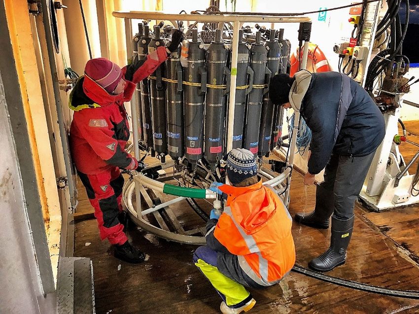
Summary of Voyages – 2017/18

TAN1707 and TAN1708: Kaikōura earthquake impact on deep-sea ecosystems
Date: 11–27 July (TAN1707); 3–17 September 2017 (TAN1708)
Lead Organisation: NIWA
Funding: NIWA SSIF
Voyage Leader: Arne Pallentin (TAN1707), Alan Orpin (TAN1708)

BACKGROUND

Major earthquakes (Mw 7.0-7.9) occur in New Zealand every ~2.5 years (23 in the last 56 years) and their
impact can be profound. While the direct and indirect human and societal impact of major earthquakes on
land is readily apparent and quantifiable, the impacts resulting from earthquake effects in the oceans are not
well understood. The 14 November 2016 Mw 7.8 Kaikōura Earthquake provided the opportunity to study the
consequence of earthquake effects for deep-sea ecosystems in the Kaikōura Canyon region.

Sediment cores collected from Kaikōura Canyon, Hikurangi Channel, and channel-overbank regions at four
days (voyage TAN1613), ten weeks (TAN1701), and 8 months (TAN1705) after the Kaikōura Earthquake, show
normally graded turbidites, consistent with a recent sediment density flow that traversed much, if not all, of
the Hikurangi Channel (Mountjoy et al., in press 2018). A comparison of seafloor photographs taken at sites
in the canyon in 2006 with those taken during TAN1701 suggest fresh deposition of sediment and the death
of large infauna at up to 1000 m water depth (Figure 1). Subsequent reconnaissance multibeam bathymetry
surveys in January and April 2017 (IKA1701 and TAN1703) determined that the parts of the upper and mid-
canyon seafloor had been eroded by tens of metres, suggesting massive sediment loss down-canyon to the
deep ocean.

Figure1. A comparison of seafloor images taken at the same site in Kaikōura Canyon in 2006 and 2017. Note the holes
and other surface features indicative of large animals living beneath the seafloor (known as bioturbatory features or
Lebensspuren) seen in 2006, and their absence in 2017.

                                                                                                                   3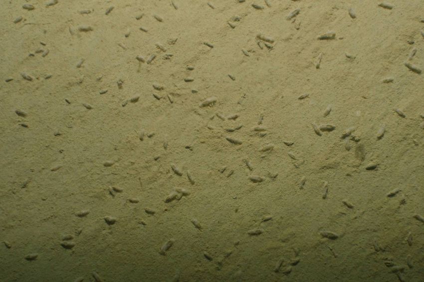
ALIGNMENT WITH OTHER RESEARCH
The multibeam mapping, benthic sampling aligned with recent MPI government funding to support research
following the Kaikōura Earthquake (proposal submitted to MBIE Endeavour Fund in 2017). The Kaikoura
surveys were complementary to ecosystem connectivity research within the canyon-focused component of
the Sustainable Seas NSC programme. The geomorphic and geological impact of the Kaikōura Earthquake on
the canyon and southern Hikurangi margin is of significant interest to a current 5-year (since 2016) MBIE
Endeavour research programme: ‘Diagnosing peril posed by the Hikurangi subduction zone: New Zealand’s
largest plate boundary fault’.
RESULTS OF SCIENCE OPERATIONS
TAN1707 completed a new multibeam survey of the Kaikōura Canyon, the Conway Trough and part of the
adjacent Hikurangi Trough. Despite weather down time of c 36 hrs and challenging oceanographic conditions,
resulting in 31 SVP casts, a total EM302 MBES coverage of 5,900 km2 was achieved. This result is nearly 100%
of the planned coverage including contingency areas, and more than could be expected at this time of year.
Data were cleaned and processed for tide, sound velocity, navigation, and motion corrections. Additionally,
all calibration tests planned were successfully conducted.
For TAN1708, these newly acquired high-resolution bathymetric data were compared to pre-earthquake
multibeam data from the canyon to determine the changes in seafloor morphology and habitat subsequent
to the Kaikōura Earthquake. This analysis identified areas where submarine landslides have likely occurred,
new areas of slope instability, and areas of landslide-deposited material. The canyon-flushing event was
sufficient to erode 10’s of metres of canyon floor and reconfigure gravel waves. These data guided targeted
sampling of the seafloor during multicorer and grab sampling to determine the distribution and character of
the deposited sediment, including turbidites.
Underway water sampling occurred throughout TAN1708 for isotopic baseline for the base of the foodweb
in the Kaikōura Canyon area using stable isotopes of carbon (C) and nitrogen (N), terrestrial organic
compound constituents into the region using compound-specific stable isotopes, and Chlorophyll a.
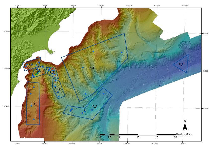
Field sampling followed hierarchical target areas (P1–P9) to sample the seafloor that had been scoured or
buried as a result of mudflows, with the highest priority given to transects with extensive pre-earthquake
data composed of DTIS video, multicores and grabs (Figure 2). The four highest priority sites also had data
collected during TAN1701, which captured benthic information ten weeks after the quake. TAN1708 found
signs of recovery in the Kaikōura Canyon seabed, 10 months after powerful submarine mudflows triggered
by the November 2016 earthquake wiped out organisms living in the seabed. There was evidence that
juveniles of animals that once dominated the head of the canyon have now begun colonising the seafloor
faster than we originally thought, with high densities of small organisms such as urchins and sea cucumbers
(Figure 3) in some areas of the canyon, as well as large numbers of rattail fishes swimming immediately above
the seabed. In the upper canyon there was evidence of eroded old muddy seafloor with fresh deposits of
soupy mud on top. In the lower canyon were gravel waves, comprising well-rounded greywacke pebbles.
These were reshaped by powerful sediment-laden flows triggered by the earthquake. Conway Trough, which
branches south off the main canyon, shows no observable impact. Among the participants in the voyage were
4
students from the universities of Waikato, Auckland and Otago, and a whale observer from Whale Watch
Kaikōura.

Figure 2: New multibeam bathymetry from TAN1707 and sample areas from TAN1708.

TAN1708 achieved 147 station records: 6 gravity core deployments, 24 DTIS deployments, 24 van Veen grab
deployments, 90 multicore deployments, 1 sound-velocity profile and 1 acoustic mooring recovery (for
another project).

                                                                                                      5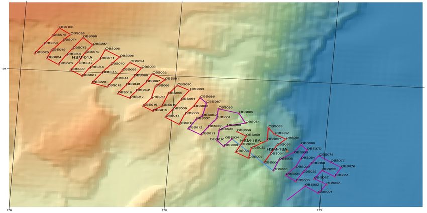
Figure 3: DTIS photographs of the seabed in Kaikoura Canyon showing (left) a dense cluster of juvenile sea cucumbers -
indicating that recovery of the deep-sea ecosystem is beginning to take place, and (right) a dense bed of tubed
foraminifera and a rattail fish – the survey in January (TAN1701) showed a barren seafloor (Figure 1).

Results of all the Kaikoura surveys indicate that an earthquake triggered a canyon sediment-flushing event
larger than the annual mud discharge for all of New Zealand’s rivers (Figure 4; Science Advances; Mountjoy
et al., 2018). This NIWA-led paper suggests earthquake-induced canyon flushing events are the single biggest
mechanism for the transport of terrigenous material from continental margins to the deep ocean, and one
of the key drivers for the morphological development of canyons on active margins. The work brought
together inputs across current MBIE strategic and Endeavour funded projects.

                                                                                                                    6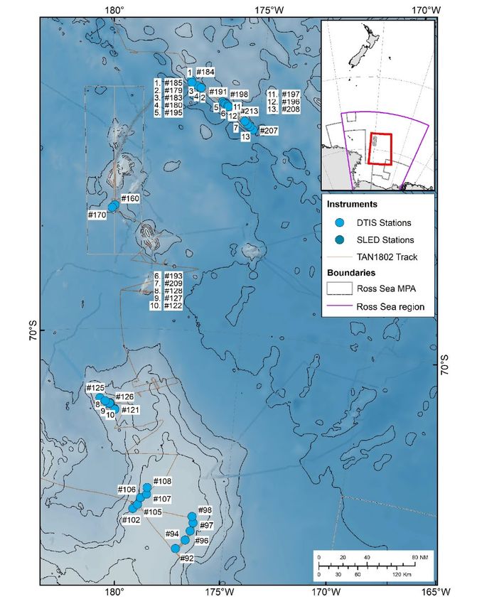
Figure 4: Evidence for catastrophic sediment flushing in Kaikoura Canyon from post-earthquake changes in bathymetry
and seafloor observations recorded during TAN1708.

PERMITING CONSIDERATIONS

As the majority of TAN1708 sampling occurred within the 12 NM Territorial Sea, the Hikurangi Marine
Reserve, and the EEZ, the voyage required permits from Environment Canterbury (ECAN), the Department of
Conservation (DOC) and the Environmental Protection Authority (EPA). Some relevant points are outlined
below:

    1. ECAN provided a Non-Enforcement Confirmation Letter (CRC180961) and stated: “While
       Environment Canterbury is not in a position to waive the requirement for resource consent, it does
       have discretion as to how to use its enforcement powers under the RMA. Our priorities lie with
       dealing with activities with more serious adverse effects first. Based on the information provided,
       Environment Canterbury would consider the potential effects of the proposed activity to be trivial.”
    2. DOC permit required notification and feedback from local iwi (Te Korowai o Te Tai o Marokura and
       Mahanui kurataiao, which has iwi representation) and Rununga (e.g. Takahanga).
    3. The area within about 2 nautical miles of Kaikōura Peninsula, as charted on NZ6212, required the
       permission of the Harbourmaster for entry by any vessel in excess of 40m LOA. ECAN granted
       permission for the RV Tangaroa to enter and remain within the area as required (Jim Dilley 17 July
       2017).

MEDIA COVERAGE AND OUTREACH

A crew from Electric Pictures Australia filming joined TAN1708 for the first three days. Interviews with the
science crew and deck shots will be used for an upcoming series exploring the forces that shape the dynamic
seafloor for National Geographic.

A media release upon the return of TAN1708 led to stories published in the NZ Herald (“Kaikoura's seabed
species bouncing back after quake”, 19 Sept 2017) and Stuff (“Kaikoura deep sea ecosystem earthquake
recovery showing hopeful signs”, 20 Sept 2017).

Rowden, A.A. (2017). Impact of the Kaikōura Earthquake on deep-sea ecosystems: feedback/korero on
      TAN1708. Te Korowai o Te Tai o Marokura meeting, Kaikōura, 16th October, 2017
Nodder, S.D., Orpin, A., Howarth, J., Mountjoy, J., Barnes, P, Rowden A., Leduc,D., Bowden, D. (2017).
      Organic carbon transfer to the deep ocean by a co-seismic turbidity current event during the
      Kaikōura Earthquake. In: Baker, J. and Rowe, M. (eds). Abstracts, Geosciences 2017, Auckland,
      Geoscience Society of New Zealand Miscellaneous Publication 134A. p. 80.
Orpin, A., Howarth, J., Nodder, S., Wallace, L. (2017). Co-seismic turbidites triggered by the Kaikōura
      earthquake. In: Baker, J. and Rowe, M. (eds). Abstracts, Geosciences 2017, Auckland, Geoscience
      Society of New Zealand Miscellaneous Publication 134A. p. 83.
Mountjoy, J.J, Howarth, J.D, Orpin, A.R., Barnes, P.M., Bowden, D.A., Rowden, A.A., Schimel, C. G., Holden,
      C., Horgan, H.J. Nodder, S.D., Patton, J.R., Lamarche, G., Gerstenberger, M., Micallef, A., Pallentin, A.,
      Kane, T. (in press 2018). Earthquakes drive large-scale submarine canyon development and sediment
      supply to deep-ocean basins. Science Advances.
                                                                                                                 7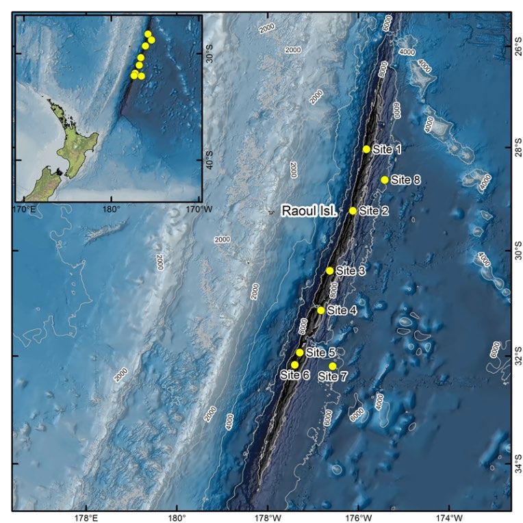
TAN1710: Ocean bottom seismograph deployment and ReCovery in support of Seismic Surveys, offshore
East Coast North Island – ORCSS1
Date: 24th October to 19th November 2017
Lead Organisation: GNS Science
Funding: GNS Science SSIF/JAMSTEC/NSF
Voyage Leader: Dan Barker

TAN1710 deployed and recovered ocean bottom seismographs (OBSs) in support of the wide-angle
reflection/refraction active source seismology component of the multi-disciplinary, international, multi-
institutional SHIRE experiment. The goals of this research are to investigate controls on processes that govern
both slip behaviour and long-term deformation at the Hikurangi margin, where a transition in slip behaviour
occurs from predominantly stick-slip in the south to a seismic creep in the north, and where a wide range of
subduction-related processes and characteristics vary along-strike. Marine and land-based active-source
seismic data from this project will show the crustal structure of the incoming plate (Hikurangi Plateau) and
overriding plate, and the subduction thrust character from the trench to the mantle wedge corner.

TAN1710 was part of a two-ship experiment coordinated with the US seismic research vessel Marcus G
Langseth to investigate the Hikurangi subduction system. In addition to acquiring multichannel seismic data,
RV Langseth provided the seismic source for wide-angle data recorded by an onshore seismograph array
across Raukumara Peninsula and offshore OBS instruments deployed from RV Tangaroa on TAN1710.

TAN1710 deployed and recovered a total of 114 OBS from the Japanese Agency for Marine-Earth Science and
Technology (JAMSTEC). These deployments were along four long regional profiles, tightly coordinated with
the RV Langseth’s seismic acquisition program. The first transect was part of an onshore-offshore experiment
from the Bay of Plenty, straddling the Raukumara Peninsula (where land seismographs were deployed) and
extending east from the Gisborne region. This was one component of an experiment designed to image the
northern Hikurangi subduction system down dip from the incoming subducting Hikurangi Plateau to deep
beneath Raukumara Peninsula. It is a northern counterpart to the SAHKE and NIGHT experiments, which
were conducted across the southern and central North Island (Henrys et al., 2013; Henrys et al., 2006);
together it is hoped these experiments can address the different seismic locking behaviour on the subduction
thrust observed at the Hikurangi margin. The second of the TAN1710 profiles runs along strike at the inner
Hikurangi margin and will also address potential north-south changes in the seismic properties of the
subduction thrust and overlying accretionary material. The remaining profiles will for the first time
characterise the along strike seismic structure of the incoming, subducting Hikurangi Plateau and provide an
eastward extension of the aforementioned SAHKE profile across the plateau.

In addition to the primary goals of acquiring active source seismic data, the OBSs serendipitously captured
several earthquakes and data can be extracted to complement other recordings of these events. We were
particularly fortunate that OBSs were deployed in the Bay of Plenty during the M4.7 and M4.8 White Island
events, 31/10/17 and 1/11/17 respectively, and their associated earthquake swarm activity. Preliminary
analysis of the data showed that the close proximity of these OBSs to the source region has resulted in the
capture of a rich record of this seismicity.

TAN1710 was a highly successful voyage. Careful planning and instrument preparation, good weather, and
skilful work by the RV Tangaroa crew combined to give us a 100% success rate – ahead of schedule – for the
full 114 deployments and recoveries. Compilation of final active source data files and their analysis will take
some time, however preliminary QC of specific OBS records indicates that the data are of high quality. Media
coverage and outreach included EastcoastLAB, Stuff, Radio NZ and TVNZ One News:
                                                                                                             8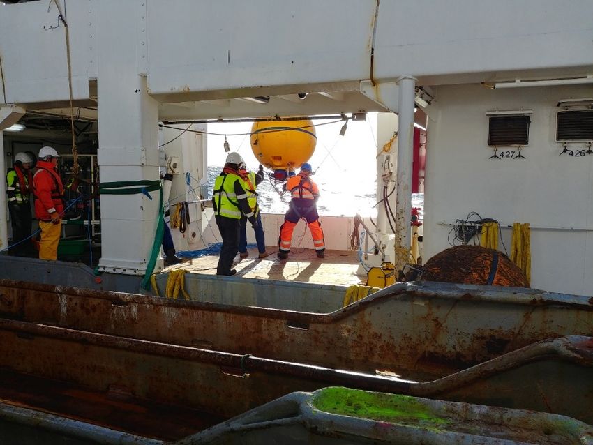
http://www.eastcoastlab.org.nz/news/multinational-probe-of-hikurangi-subduction-zone-gets-underway/
https://www.stuff.co.nz/science/97916235/
https://www.radionz.co.nz/news/national/341824/scientists-on-quake-fact-finding-mission
https://www.tvnz.co.nz/one-news/new-zealand/team-international-scientists-studying-active-zone-off-north-islands-east-coast-
capable-triggering-megathrust-quake
Other outreach and engagement was conducted prior to and during the voyage with various stakeholders
including Iwi and commercial offshore fishing enterprises.

Henrys, S., Wech, A., Sutherland, R., Stern, T., Savage, M., Sato, H., Mochizuki, K., Iwasaki, T., Okaya, D., Seward, A., Tozer, B.,
          Townend, J., Kurashimo, E., Iidaka, T., and Ishiyama, T., 2013, SAHKE geophysical transect reveals crustal and subduction
          zone structure at the southern Hikurangi margin, New Zealand: Geochemistry, Geophysics, Geosystems, v. 14, no. 7, p.
          2063-2083.
Henrys, S. A., Reyners, M. E., Pecher, I. A., Bannister, S. C., Nishimura, Y., and Maslen, G., 2006, Kinking of the subducting slab by
          escalator normal faulting beneath the North Island of New Zealand: Geology, v. 34, no. 9, p. 777-780, doi:
          710.1130/G22594.22591.

   Figure 1. Map showing deployment locations for                    Figure 2. OBS deployment.
         114 OBS along four regional profiles.

                                           Figure 3. Preliminary OBS shot gather.
                                                                                                                                         9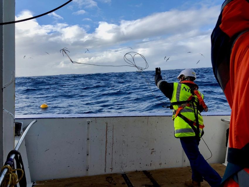
TAN1712: Ocean bottom seismograph deployment and ReCovery in support of Seismic Surveys, offshore
East Coast North Island – ORCSS 2
Date: 16th to 21st December 2017
Lead Organisation: GNS Science
Funding: GNS Science SSIF/NSF/NERC/JAMSTEC
Voyage Leader: Richard Kellett

TAN1712 was the second of three ORCSS voyages. On this leg, ocean bottom seismographs (OBSs) were
deployed in support of multi-disciplinary, international, multi-institutional 3-dimensional seismic experiment
(NZ3D). The goals of this research are to investigate controls on processes that govern both slip behaviour
and long-term deformation at the Hikurangi margin. Marine and land-based active-source seismic data from
this project will show the crustal structure of the incoming plate (Hikurangi Plateau) and overriding plate,
and the subduction thrust character from the trench to the mantle wedge corner. The track for the voyage is
shown in Figure 1.

TAN1712 deployed a total of 100 OBS from the Japanese Agency for Marine-Earth Science and Technology
(JAMSTEC). Figure 2 shows the deployment of an OBS from the RV Tangaroa cut-away. These deployments
were spaced approximately every 2 km on an irregular rectangular grid 6 km x 48 km perpendicular to the
Gisborne coast, forming four parallel lines of 25 OBS (Figure 3). In this location, the subduction thrust slips
predominantly in well-documented transient slow slip events (SSEs) rather than large stick-slip earthquakes.
From 6 January until 9 February 2018, the RV Langseth will acquire a 3D seismic reflection data set over the
top of the seafloor OBS array. The energy from the RV Langseth seismic source will be recorded by the OBS
and an array of seismometers onshore. The irregular grid is designed to avoid artefacts in subsequent 3-
dimentional image processing of the data. This dataset will give NZ scientists and the global geophysical
community the first high-resolution images and seismic attributes of a transient-slip plate boundary
megathrust. The Gisborne area is important as a comparison to predominantly locked subduction thrusts of
Nankai, Tohoku, Cascadia, and Costa Rica. The northern Hikurangi margin, targeted here, is the only
subduction zone in the world where well-documented SSEs occur at 5-10 km depth (vs. typical 25- 50 km
depths) i.e. shallow enough for detailed seismic imaging and seismic attribute measurements. Following the
RV Langseth survey, 25 of the OBS will record earthquakes and other natural seismic signals. The instruments
will be recovered on the ORCSS 3 voyage from 28 March to 8 April 2018.

In addition to the OBS deployments, we achieved our secondary goal of collecting a set of 20 water samples
for Hawkes Bay Regional Council (HBRC). Samples were collected within the 12-mile boundary of the NZ
territorial waters. The sample interval is approximately five nautical miles (Figure 1). At each sample location
three 1-L bottles were filled from the underway water sampling outlet. Analysis of nutrient (e.g. nitrogen and
phosphorus species) concentration and dispersal through Hawke Bay will be investigated back in the
laboratory.

TAN1712 was a highly successful voyage. Careful planning and instrument preparation, good weather, and
skilful work by the RV Tangaroa crew resulted in the deployment of 100 instruments in 36 hours. The
activities on the RV Tangaroa were coordinated with the concurrent IODP JOIDES Resolution expedition 372.
The entire voyage was completed two days ahead of schedule. Voyage photos and stories were posted to
the GNS Science Facebook and Instagram pages, and our voyage was also highlighted by the JOIDES
resolution team on their social media and blogs:

                                                                                                             10
https://www.facebook.com/gnsscience/posts/10159633087310004
https://www.facebook.com/gnsscience/photos/a.10159019729375004.1073741829.10150115509595004/
10159633067955004/?type=3&theater
https://www.facebook.com/gnsscience/posts/10159628563945004
https://www.facebook.com/gnsscience/posts/10159624110235004
Figure 1. Map showing track of the voyage and underway Figure 2. OBS deployment with RV Tangaroa
water sampling stations. cut-away A-frame.
Figure 3. Location map of 100 OBS deployed during the voyage. Area shown corresponds to the inset box
labelled in Figure 1.
11TAN1711: Kermadec Trench
Date: 24 November – 14 December 2017
Lead Organisation: University of Southern Denmark
Funding: European Research Council and NIWA SSIF
Voyage Leaders: Ronnie Glud (USD) and Ashley Rowden (NIWA)
The HADES‐ERC project aims to provide the first detailed, combined analysis of benthic diagenesis and
microbial ecology of some of the deepest oceanic trenches on Earth. We argue that deep trenches, some of
the most remote, extreme, and rarely explored habitats on Earth, are hotspots of deposition and
mineralization of organic material. By comparing trenches from contrasting oceanic settings the project
provides a completely novel general analysis of hadal biogeochemistry and the role of deep trenches in the
oceans, as well as fundamental new insights into the composition and functioning of microbial communities
at extreme pressure.
This voyage was the first of the series of expeditions exploring selected trenches of the Pacific Ocean. The
research on this voyage is primarily funded by a 5-year European Research Council Advanced Grant, with
additional support from various national research programmes (including from NIWA). Overall the HADES-
ERC project will investigate carbon and nutrient cycling by microbial communities in trenches exposed to
different rates of organic carbon supply. To overcome potential difficulties in recovering samples to the
research vessel unaffected by pressure changes, investigations were primarily conducted by autonomous
lander systems.
However, beside this focus of the HADES-ERC project, the upcoming voyages enable important,
complementary and more general investigations on life in the trenches. For the Kermadec Trench voyage this
included the distribution and importance of benthic meiofauna and macrofauna in trench systems, aging of
dissolved organic carbon in trench water, and surveys of the seafloor variability in the trench.
The scientific team covered a range of complementary disciplines. Even though data, samples and ideas will
be shared across sub-teams, the scientific personnel were divided into 7 interlinked sub-projects (see below).
Observations of whales provided an additional opportunistic voyage objective.
Six nominal sites along the central axis of the Kermadec Trench and two abyssal references sites were
selected prior to the voyage (Figure 1). The trench sites were chosen to cover the maximum range of
anticipated carbon deposition rates along the trench axis. Estimates were derived from different modelling
approaches using a range of parameter settings. The two reference sites simply represent a northern and a
southern site covering any potential latitude gradient in ocean productivity. However, early on it was decided
to exclude the northern reference site (Site 8) and give priority to investigations along the trench axis.
12Figure 1: Bathymetric map showing study
sites in the Kermadec Trench. Inset shows
the study area relative to New Zealand.
The following equipment were deployed at the study sites: i) different lander systems (e.g. Figure 2), ii) a
6000 m-rated CTD bottle rosette, iii) a Hadal–rated bottle rosette, and iv) multi-corer and box-corer. In
addition, the deployment of a new lander system under development at NIWA was planned for hadal testing,
if time allowed (unfortunately it did not).
Figure 2: The basic structure and deployment
configuration of the P-lander (right) & the S-Lander (left)
Sub-projects 1 and 2 are closely linked. However, sub-project 1 primarily focused on i) in situ microprofiling,
ii) basic solid phase and porewater analyses on recovered sediment. Sub-project 2 mainly focused on i)
microbial/viral analysis in recovered sediment cores, and ii) test of in situ fixation procedures of water
samples.
Sub-project 3 focused on the distribution of natural radionuclides in the water column and sediments to
investigate deposition and mixing of particulate material. This work will be complemented with detailed sand
13grain analyses, basic geological characterization and a range of geochemical analyses of stable isotopes and
biomarkers. Sub-project 4 focused on characterizing and quantifying the communities of foraminifera of
recovered sediment cores. Sub-project 5 conducted investigations on the sources and the age of dissolved
inorganic carbon in mesopelagic, abyssal and hadal waters, as well as pelagic sampling for metagenomics.
Sub-project 6 investigated, characterized and quantified benthic communities of meiofauna (nematodes in
particular) and macrofauna, and also quantify pollen and stored samples of eDNA. This sub-project aimed to
further characterize scavenging amphipod communities along the trench axis. Sub-project 7 aimed to
observe long-term natural macrofauna abundance and activity at the abyssal plain (Site 7), and the habitat
heterogeneity and sediment characteristics of the seafloor (Figure 3). Limited analysis of samples and data
was possible during the voyage, and the results of the research are largely dependent upon laboratory
analysis yet to occur.
Figure 3: Photograph of the seafloor
(taken with the Short-term Camera
Lander) at the deepest location in
the Kermadec Trench (9996 m,
Scholl Deep, Site 4)
In total, there were 18 marine mammal sightings, with 11 being Common Dolphin (Delphinus delphis)
sightings. Furthermore, at least 22 species of seabirds were identified.
Attempting wire-based sampling operations at the seabed >9000 m is a challenge, and indeed few vessels in
the world are currently equipped with sufficient wire to attempt such operations. During this voyage, success
was achieved with the multi-corer and box-corer, demonstrating RV Tangaroa’s capability to sample the full
depth extent of New Zealand’s EEZ (10,000 m) useing wire-operated scientific devices.
The voyage attracted some media attention, although perhaps not as much as it should have given the
relatively unique nature of the study in New Zealand waters. Media releases were prepared for distribution
before and after the voyage. A small number of articles appeared in the New Zealand press, and ONE News
presented a short segment on the voyage after filming took place on the RV Tangaroa after its return.
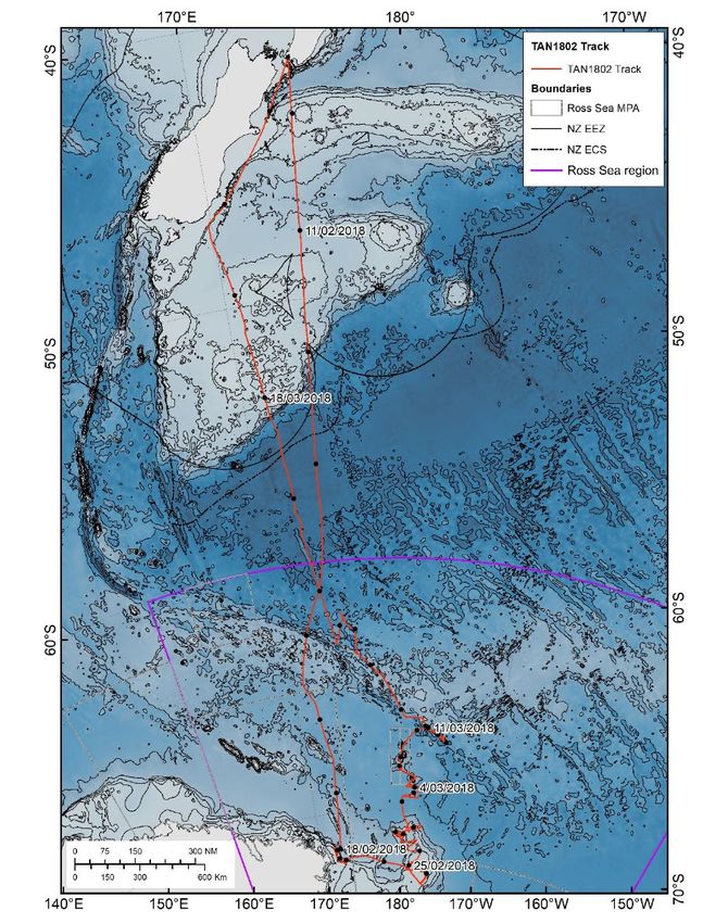
14TAN1802: Ross Sea Environment and Ecosystem Voyage 2018
Location: Ross Sea
Dates: 7 February to 21 March 2018
Lead organisation: NIWA
Funding: MBIE; MBIE Endeavour; Deep South National Science Challenge; NIWA SSIF, and University of
Auckland
Voyage Leader: David Bowden (NIWA)
The Ross Sea Environment and Ecosystem Voyage 2018 (TAN1802), took place from 9 February to 21 March
2018, departing from and returning to Wellington, New Zealand. Science objectives for the voyage were
aligned with the Ross Sea Region Marine Protected Area Research and Monitoring Plan, under New Zealand’s
Antarctic and Southern Ocean science directions and priorities 2010-2020. Funding for vessel time came from
the New Zealand Ministry for Business Innovation and Employment (MBIE), with science funding from: MBIE
Endeavour Fund project Ross Sea Research and Monitoring Programme – is the world’s largest MPA effective?
(Ross-RAMP); New Zealand’s Deep South National Science Challenge; NIWA Strategic Science Investment
Funds; and the University of Auckland. The Ross-RAMP project was the largest single funder of the research,
supporting six of ten research objectives selected initially via the Tangaroa Antarctic Reference Group’s
Expression of Interest (EOI) process.
In addition to the core research objectives of the voyage, requests from the New Zealand Meteorological
Service to deploy surface-drifting weather buoys as part of the international Global Drifter Program, and from
MetOcean Solutions Ltd and the New Zealand Government to deploy wave-monitoring drifters, were
incorporated into the voyage plan.
The voyage was very successful, largely following its planned route (Figure 1) and achieving all objectives in
part and most in full, including: (1) establishing a long-term experiment to monitor outflow of Antarctic
Bottom Water at the continental shelf-break in the Cape Adare region (Figure 2, left); (2) surveys of seabed
habitats and fauna at previously un-surveyed sites on Iselin Bank, Scott C seamount, and locations on the
Pacific-Antarctic ridge (Figure 2, right); (3) characterisation of marine microbial community structure and
function across the region; (4) characterisation of zooplankton community structure; (5) surveys of
mesopelagic fish and krill distributions; (6) research into interactions between marine aerosols and cloud
formation; (7) documenting marine mammal distributions, including biopsy sampling of humpback whales,
and (8) deploying a total of 31 instrumented drifter buoys.
Seven instrumented moorings were deployed during the voyage as components of these research objectives:
three carrying oceanographic instruments to monitor water-column properties as part of the Ross Outflow
experiment; three with passive acoustic instruments to record whale vocalisations, and one with an upward-
looking active echosounder to record mesopelagic fauna, including silverfish and krill. All moorings will
remain in situ, recording data, for at least 11 months, with recovery planned for early 2019, when Tangaroa
is scheduled to return to the area.
Results from the voyage will enhance understanding of fundamental oceanographic, atmospheric, and
ecological processes in the Ross Sea region, inform decision-making in relation to the objectives of the Ross
15Sea MPA, and expand our knowledge of seabed habitats and faunal distributions in the region. A full Voyage
Report is available from NIWA (https://www.niwa.co.nz/our-services/vessels/voyage-reports-and-data) and
a voyage summary has been submitted as a paper to CCAMLR.
Figure 1. TAN1802 voyage track, showing daily noon positions and Sunday dates.
16Figure 2. Left: Hydrographic transects and instrumented mooring locations in the Ross Outflow Experiment.
Numbers are sequential station numbers. An active acoustic mooring (#77) was deployed as part of the mesopelagic
fauna objective of the voyage. Right: Seabed survey sites occupied (note, some station numbers are detailed in
offset lists). DTIS: Deep Towed Imaging System, SLED: epibenthic sled. Multibeam echosounder surveys were
completed encompassing all sites
17TAN1803: Ocean bottom seismograph deployment and ReCovery in support of Seismic Surveys, offshore
East Coast North Island – ORCSS3
Date: 28 March to 6 April 2018
Lead Organisation: GNS Science
Funding: GNS Science SSIF/JAMSTEC/NSF
Voyage Leader: Dan Bassett
TAN1803 recovered ocean bottom seismographs (OBSs) in support of the 3D wide-angle reflection/refraction
component of the international NZ3D experiment. The work was coordinated with the US academic seismic
research vessel RV Marcus Langseth and the US IODP academic drilling vessel RV JOIDES Resolution. The goals
of this research are to investigate controls on processes that govern both slip behaviour and long-term
deformation at the Hikurangi margin at a focused region offshore Gisborne. A wide range of subduction-
related processes occur beneath the Gisborne region, including slow-slip earthquakes, tremor, and micro-
seismicity, where seamounts are subducting beneath the margin. Using the RV Langseth, the NZ3D survey
collected high-resolution seismic reflection data over this region; this survey was complemented by Japanese
Agency for Marine-Earth Science and Technology (JAMSTEC) OBSs, which also recorded the Langseth sound
sources. The data collected is combined to create 3D image of the subduction zone down to a depth of
approximately 15km below the surface.
TAN1803 was the last of three RV Tangaroa voyages tightly coordinated around two companion voyages by
the RV Langseth. TAN1710 and MGL1708 collected a regional dataset of seismic reflection and wide-angle
seismic refraction data along the Hikurangi margin. TAN1712 then deployed 100 OBSs in a tight array offshore
Gisborne, prior to MGL1801 collecting 3D seismic over this region. The goal of TAN1803 was to recover these
100 OBSs.
TAN1803 recovered a total of 97 OBS of the 100 that were deployed. The deployment was in a rectangular
area of 6 km by 48 km centred on the IODP Leg 372/375 Hikurangi Margin drill holes. Our voyage began by
first making a delivery of “O-rings” to the academic drilling vessel RV JOIDES Resolution. These O-rings were
crucial for the successful installation of borehole observatories. We then proceeded to recover 13 OBSs
located within 2NM of borehole site HSM18A (Figure 1). These were collected first, so we could maintain a
safe operating distance from the JOIDES Resolution when she returned to this site several days later. We
then transited up to the northwest of our array, and proceeded to collect OBSs snaking down the array from
NW-SE (Figure 1).
During our recovery operations we encountered three sites where no acoustic response was received from
the OBS. These were OBS # 100, 91 and 45. At each location, we spent approximately three hours on station
attempting to acoustically release the OBS from three positions located N, SW and SE from the deployment
site. After each attempt, we waited for a time equal to the expected instrument rise time before attempting
the next release command. Unfortunately, these attempts were all unsuccessful, so we proceeded with the
recovery of the remaining OBSs on the seafloor. At the successful conclusion of our recovery operations, we
returned to sites 100, 91 and 45 where we made additional efforts to recover the instruments but these too
were unsuccessful so after exhausting all possible recovery options we returned to port.
TAN1803 was a highly successful voyage. Careful planning and instrument preparation, good weather, and
skilful work by the RV Tangaroa officers and crew combined to give us a 97% success rate – ahead of schedule.
Over the course of the full SHIRE/NZD experiments encompassing TAN1710, TAN1712 and TAN1803 this
success rate was 98.6%. Compilation of final active source data files and their analysis will take some time,
however preliminary QC of specific OBS records indicates that the data are of high quality. Outreach and
18engagement was conducted prior to and during the voyage with various stakeholders, including commercial
offshore fishing enterprises.
Figure 1 – OBS recovery locations and IODP borehole sites. X’s indicate unrecovered OBSs.
Figure 2 – Launch off the Joides Resolution on its way to collect O’Rings from RV Tangaroa
19TAN1805 - Resilience Of deep-sea Benthos to the Effects of Sedimentation (ROBES)
Area: Chatham Rise
Period: 9 May – 7 June 2018
Lead organization: NIWA
Funding: MBIE Endeavour
Voyage leader: Malcolm Clark
Background
This voyage was the first of three surveys designed to determine the effects of sedimentation, and the
resilience and potential recovery of impacted benthic communities. This survey was designed to subject an
area of seabed to disturbance creating a sediment plume. The resultant suspended sediment load was then
tracked and monitored, by pre and post-disturbance sampling program to determine the effects on faunal
community structure at an increasing distance from the impact. A repeat of the survey (post-disturbance
survey) is planned for 2019 and 2020, to determine the longer-term resilience and recovery dynamics of
disturbed communities.
The survey
The survey was centred on the mid-Chatham Rise, east of a licence area held by Chatham Rock Phosphate,
and several nautical miles north of the northern boundary of the Mid-Chatham Benthic Protection Area. It
was an area of relatively uniform slope, with no topographic features, but patches of coral communities
(dominated by Goniocorella dumosa) on exposed rock and cobble substrate.
The location of the survey (left) and an example of a coral-dominated community in the area (right)
The location of the monitoring sites (coded “Mon” in the figure below) was considerably different from the
theoretical plan, as the patchiness of the biology did not allow an axis monitoring approach as planned.
Instead, the design was driven by a more circular gradient, with varying distances to the monitoring sites
across a number of directions from the disturbance site.
20Detail of the survey area, showing the cluster of monitoring stations around the main disturbance area (yellow polygon) and the
control site to the northwest.
The physical disturbance was conducted with a specially designed “benthic disturber” which was used in
similar disturbance experiments in the 1990s by US, UK, Japanese and Indian research programmes,
investigating effects on manganese nodule communities on the abyssal plains, in the central Pacific and
Indian oceans. It was refurbished and specifically modified for use off Tangaroa.
Baseline data were collected on bathymetry, topography, water column characteristics, sediment
composition, and faunal community structure and abundance prior to disturbance, and then up to twice
post-disturbance at some sites. Current flow was assessed using the vessels ADCP, NIWA’s underwater glider,
and a moored ADCP. Water column data were collected from a CTD-rosette, multibeam echo-sounder
(backscatter), and multi-frequency fisheries acoustics sounders. Several sounder transect surveys were run
to map the area of disturbance, pre and post-disturbance, and a CTD grid was completed immediately after
disturbance events to sample the plume. Three new benthic landers were deployed downstream of the
disturbance site with an array of sensors, including sediment traps. Detailed sediment sampling with the
multicorer (supporting onboard respiration experiments as well as sediment profile data), and extensive DTIS
towed camera stations were completed. Live deep-sea sponges were also collected for sedimentation
experiments back at the laboratory. Three mooring arrays were re-deployed at the end of the survey for a
21further 12 months to monitor current and sediment dynamics. In total over 250 gear deployments were
carried out.
The Benthic Disturber failed to produce as extensive a sediment plume as hoped, as the fluidising system
didn’t penetrate and stir up the heavier sandy component of sediments in the area. The fine sediments in
the upper few cm of the substrate appeared to disperse rapidly in the relatively fast bottom current
conditions. Nevertheless, the complex interaction of multiple gear types and disciplines planned for the
survey worked well overall, and the survey has collected a large amount of oceanographic, sedimentological,
and biological data that will support a wide variety of analyses in coming months.
22TAN1804: Campbell Plateau 2018
Area: Campbell Plateau
Date: 12-24 April 2018
Lead Organisation: NIWA
Funding: NIWA SSIF
Voyage Leader: Phil Sutton
BACKGROUND
Campbell Plateau is an oceanographically-interesting area which separates the Subantarctic flowing around the
southern flank of the plateau from the Subtropical Front to the north. Previous analyses have indicated that sea
surface height on the plateau behaves anomalously in that it is not driven by density (thermal) changes, but by
convergence and divergence of mass on the plateau. That is, water either ‘piles up’ or ‘drains off’ the plateau on
intra-annual timescales. Furthermore, the plateau is an area where Subantarctic Mode Water is formed as a
result of winter mixed layers extending almost to the seafloor. This water then subducts into the surrounding
ocean, effectively sequestering heat and CO2 for hundreds of years. Three moorings were deployed on the
plateau in 2017 to collect year-round data to determine the dynamics responsible for this behaviour.
Two CTD transects were planned, repeating earlier work to provide measurements of change. The first was
across the Southland Current east of Otago, the second was underneath a satellite altimeter track across the
Subantarctic Front southeast of Campbell Plateau.
Stations.
SCIENCE OPERATIONS
TAN1804 was unfortunately impacted by bad weather, with a storm delaying departure from Wellington
and further bad weather (high winds and rough seas) interrupting work. Despite the weather, the critical
23mooring recoveries were achieved with 100% success rate (all of the gear was recovered). Unfortunately,
time lost due to weather meant that not all of the planned CTDs were conducted.
i) Mooring recoveries
Grappling for the first mooring.
The three moorings were recovered as weather allowed. All of the gear was successfully
recovered and all of the instruments recorded data. No analysis has been carried out to date.
Recovering a moored long-range ADCP
ii) CTD/Water sampling
CTD dataset CTD3228 consisted of 25 stations, named u8961 to u8985. There were no
multi-cast stations, corresponding to repeat deployments of the CTD for either
24scientific or instrumental reasons. There were no stations where data acquisition was
interrupted due to instrumental issues.
CTD station information:
Stn no. lat lon date time depth
u8961 -46.305 170.146 13-Apr-2018 23:32 56
u8962 -46.452 170.295 14-Apr-2018 01:04 146
u8963 -46.538 170.385 14-Apr-2018 02:09 608
u8964 -46.659 170.503 14-Apr-2018 07:06 789
u8965 -46.775 170.627 14-Apr-2018 08:53 1001
u8966 -46.974 170.800 14-Apr-2018 11:20 1154
u8967 -47.149 170.981 14-Apr-2018 13:46 1240
u8968 -47.415 171.226 14-Apr-2018 17:25 1327
u8969 -47.710 171.534 14-Apr-2018 20:54 1356
u8970 -49.252 166.963 16-Apr-2018 05:53 567
u8971 -49.296 166.786 16-Apr-2018 10:16 601
u8972 -49.599 166.799 16-Apr-2018 18:27 460
u8973 -49.770 166.784 16-Apr-2018 20:10 139
u8974 -50.988 168.501 18-Apr-2018 07:37 624
u8975 -51.415 172.207 19-Apr-2018 05:52 523
u8976 -50.691 171.993 19-Apr-2018 13:23 497
u8977 -51.087 172.495 20-Apr-2018 03:39 535
u8978 -51.439 172.944 20-Apr-2018 07:28 538
u8979 -51.701 173.279 20-Apr-2018 10:18 573
u8980 -52.002 173.665 20-Apr-2018 13:10 825
u8981 -52.305 174.063 20-Apr-2018 16:33 1272
u8982 -52.520 174.352 20-Apr-2018 19:41 3258
u8983 -52.649 174.524 20-Apr-2018 23:07 3719
u8984 -52.770 174.713 21-Apr-2018 02:55 4295
u8985 -53.028 175.071 21-Apr-2018 07:57 4786
25Drawing water samples from the CTD Niskin bottles.
Water sampling for chemistry
Water samples were collected on the voyage for chemical analysis. Thirty-four (34) samples were
collected for carbonate analyses as part of an ongoing project to understand the carbon
(carbonate) concentrations in the oceans around New Zealand.
Seventy-one (71) samples were also collected for nutrient (nitrate, phosphate and silicate) and
barium analyses for a collaborator Rob Sherrell (Rutgers University, USA). The nutrient and
barium analyses, along with the hydrographic parameters, will help to understand the
environmental conditions.
iii) Multibeam and sub-bottom profiling.
Multibeam mapping and sub-bottom profiles were opportunistically collected during the voyage
as there are few multibeam bathymetry data for the Campbell Plateau.
The multibeam data and backscatter data show that the plateau is predominantly flat, but with
occasional features such as scours.
In general, the Topas produced a range of different types and styles of data. Across the shallow
areas around Stewart Island and Auckland Island there was little penetration of the sub-bottom
profile signal, suggesting that these regions are covered by coarse shell hash. However, there
were some large channels evident east of Auckland Island. Just off the shelf east of Stewart Island
there were some interesting white features in the Topas signal which will be further investigated.
Across the centre of the plateau, east of Auckland Island, the Topas signal penetrated to almost
200 m, displaying continuous layers with occasional unconformities. These sub-bottom profile
data will be used by Ben Cathie (VUW) for his MSc student to attempt to understand the Cenozoic
evolution of the Campbell Plateau in conjunction with the limited sediment surface samples and
core data from this region.
26Sub-bottom profile line east of Stewart Island shows white blobs (possibly carbonate reefs)
overlying sediment layers.
2728
You can also read