SECURE AVIATION DATA INFORMATION SERVICE (SADIS) USER GUIDE
←
→
Page content transcription
If your browser does not render page correctly, please read the page content below

SECURE AVIATION DATA
    INFORMATION SERVICE (SADIS)
           USER GUIDE
 Part 1 – General and Administrative
                 To be read in conjunction with Part 2 - Technical

                           Sixth Edition — June 2016

                        Endorsed by METP WG MOG/15

Prepared by the ICAO Meteorological Panel Meteorological Operations Working Group
                                   (WG MOG)

          INTERNATIONAL CIVIL AVIATION ORGANIZATION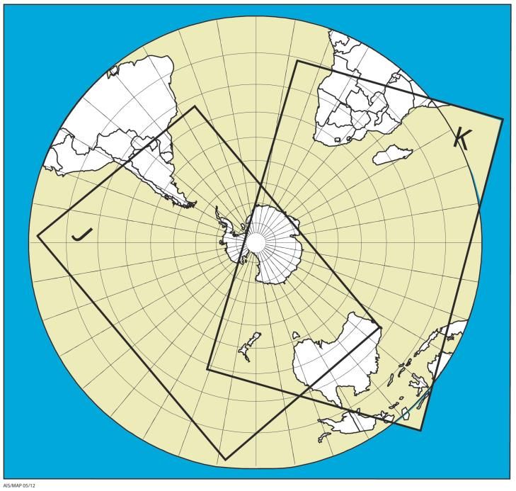
RECORD OF AMENDMENTS AND CORRIGENDA

                   AMENDMENTS                                       CORRIGENDA
No.     Date                Pages affected             No.   Date          Pages affected
1      7/7/2016             Original issue
2.0   12/1/2017    SUG Annex 1 description (2.7.5;
                                Annex 1)
                   Update of webpage links (3.2.1)
                   Removal of temporary references
                        to new flight levels (now
                     introduced) (Annex 4-3, 4-3)
                    Reference to 1 hour delay each
                    year by each WAFC to WAFC
                      SIGWX data issued during
                   WAFC Backup events (Annex 4-
                      5; 4-7). Editorial corrections

                       Addition of Space Weather
                    forecasts and minor adjustment
2.1   24/04/2018              to formatting.
                     Updated web links, 2.7.5 and
                     2.7.6 description. Reference
                    added to workstation evaluation
                   guide. New area of responsibility
                   map. Layout of App E. Annex 1
                     wording to reference OPMET
                    catalogue. Annex 5 updated to
                      space weather section, and
                       inclusion of low level area
2.2   11/04/2019               forecasts.
                       Addition of IWXXM format
                     OPMET data sets, and higher
                     resolution WAFS hazard data
2.3   05/11/2020                  sets.
                       Appendices to the SUG
2.4   20/04 2021    restructured and consolidated.
TABLE OF CONTENTS
Page
Glossary ............................................................................................................................................. iii
Chapter 1. Introduction to the Secure Aviation Data Information Service (SADIS)
1.1 Background .......................................................................................................................... 1
1.2 A brief description of the service .......................................................................................... 2
1.3 Management of SADIS ........................................................................................................ 2
1.4 Authorized access to SADIS ................................................................................................ 3
1.5 SADIS cost allocation and recovery ..................................................................................... 3
Chapter 2. Products and data available on SADIS
2.1 Overview of products and data available on SADIS ............................................................ 4
2.2 Digital grid point (GRIB) data ............................................................................................... 4
2.3 Digital SIGWX in the BUFR code form ................................................................................ 6
2.4 Digitally coded charts .......................................................................................................... 6
2.5 OPMET information in alphanumeric format ........................................................................ 8
2.6 OPMET information in IWXXM format ………………………………………………………….. 8
2.7 Administrative messages ..................................................................................................... 9
2.8 Schedule of availability ........................................................................................................ 9
2.9 The evolution of products and data on SADIS ..................................................................... 9
Chapter 3. Recommended basic requirements for data processing systems
3.1 General requirements .......................................................................................................... 10
3.2 Sources of information regarding potential suppliers of equipment to
process/display products and data made available on the SADIS ...................................... 10
Chapter 4. User support
4.1 Technical support by the SADIS Provider ........................................................................... 11
4.2 24-hour helpline/faults desk ................................................................................................. 11
4.3 General contact facilities during office hours ....................................................................... 11
4.4 System development contact facilities ................................................................................ 11
4.5 Assistance for implementation ............................................................................................. 12
4.6 SADIS backup procedures .................................................................................................. 12
(i)APPENDICES
Appendix A —Authorisation to use SADIS .......................................................................................... A-1
Appendix B — Data available on SADIS ............................................................................................. B-1
Appendix C —Data processing systems ............................................................................................. C-1
(ii)GLOSSARY
ABBREVIATIONS AND TERMS
AFS Aeronautical fixed service
AFTN Aeronautical fixed telecommunication network
AIREP Air-report
ANP Air navigation plan
ATC Air traffic control
BCC Bulletin compiling centre
BUFR Binary universal form for the representation of meteorological data
CB Cumulonimbus cloud
EANPG European Air Navigation Planning Group
FIR Flight information region
FL Flight level
FTP File transfer protocol
GAMET Area forecast for low-level flights
GRIB2 Gridded binary code (WMO) — Edition 2
GZIP A file format used for file compression and decompression
IFR Instrument flight rules
IP Internet Protocol
IWXXM ICAO Meteorological Information Exchange Model
LDC Least developed countries
METAR Aerodrome routine meteorological report
METP Meteorological Panel (ICAO)
MHz Megahertz
NATS National Air Traffic Services
OPMET Operational meteorological (information)
PNG Portable network graphics
SADIS Secure Aviation Data Information Service (formerly, until 1 August 2016, Satellite
Distribution System for Information Relating to Air Navigation)
SADISOPSG SADIS Operations Group (disbanded 2015, but reference retained for historical
context)
SADIS Provider United Kingdom Met Office
SADIS Provider State United Kingdom, represented by the Head of the Meteorological Authority, United
Kingdom Civil Aviation Authority
SARPs Standards and Recommended Practices
SCRAG SADIS Cost Recovery Administrative Group
-iii-SIGMET Information concerning en-route weather phenomena which may affect the safety
of aircraft operations
SIGWX Significant weather (charts, forecasts)
SPECI Aerodrome special meteorological report
SUG SADIS User Guide
SVC Switched virtual circuit
SWH High-level SIGWX
SWM Medium-level SIGWX
TAC Traditional Alphanumeric code format
TAF Aerodrome forecast
TCAC Tropical cyclone advisory centre
TCP Transmission control protocol
UPS Uninterruptable power supply
UTC Co-ordinated Universal Time
VAAC Volcanic ash advisory centre
WAFC World Area Forecast Centre (London and Washington)
WAFS World area forecast system
WAFSOPSG WAFS Operations Group (disbanded 2015, but retained for historical context)
WIFS WAFS internet file service
WG-MOG Meteorological Operations Group (reporting to METP)
WG-MIE Meteorological Information Exchange (reporting to METP)
WG-MISD Meteorological Information and Service Development (reporting to METP)
WG-MRI Meteorological Requirements and Integration (reporting to METP)
WMO World Meteorological Organization
WIFS Provider United States National Weather Service Aviation Weather Center
WIFS Provider State United States, represented by the Head of the Meteorological Authority,
United States Federal Aviation Administration
-iv-DOCUMENTS
Doc 7910 Location Indicators
Doc 9082 Statements by the Council to Contracting States on Charges for Airports and Air
Navigation Services
Doc 9855 Guidelines on the Use of the Public Internet for Aeronautical Applications
Air Navigation Plans
Doc 7754 Air Navigation Plan — European Region
Doc 7474 Air Navigation Plan — Africa-Indian Ocean Region
Doc 8733 Air Navigation Plan — Caribbean and South American Regions
Doc 8755 Air Navigation Plan — North Atlantic, North American and Pacific Regions
Doc 9634 Air Navigation Plan — North Atlantic Region
Doc 9673 Air Navigation Plan — Asia and Pacific Regions
Doc 9708 Air Navigation Plan — Middle East Region
Documents available from ICAO Regional Offices
AFI MET Bulletin Exchange (AMBEX) Handbook (available from the ICAO WACAF and ESAF Offices)
Regional OPMET Bulletin Exchange (ROBEX) Handbook (available from the ICAO APAC Office
EUR OPMET Data Management Handbook (available from the ICAO EUR/NAT Office)
-v-Chapter 1
INTRODUCTION TO THE SECURE AVIATION DATA INFORMATION
SERVICE (SADIS)
1.1 BACKGROUND
1.1.1 The purpose of this SADIS User Guide is to give an overview of the system and provide helpful
information to potential users. It is intended to complement the technical manuals which will accompany the
individual SADIS workstation and software provided by 3rd parties. The SADIS User Guide is made available
on the ICAO METP website.
1.1.2 Additional system information is available from the Met Office SADIS website at URL:
https://www.metoffice.gov.uk/services/transport/aviation/regulated/sadis/index
1.1.3 The objective of the world area forecast system (WAFS) is to supply meteorological authorities
and other users with global meteorological en-route forecasts in digital form. This objective is to be achieved
through a comprehensive, integrated worldwide, and, as far as is practicable, uniform system and in a cost-
effective manner, taking full advantage of evolving technologies (Annex 3 — Meteorological Service for
International Air Navigation1, 3.1 refers). The meteorological information to be provided comprises forecasts
of global:
a) upper wind;
b) upper-air temperature;
c) upper-air humidity;
d) geopotential altitude of flight levels;
e) direction, speed and flight level of maximum wind;
f) flight level and temperature of tropopause;
g) horizontal extent and flight levels of base and top of cumulonimbus clouds;
h) icing;
i) turbulence; and
j) significant weather phenomena.
1 “Annex 3” will be used to refer to ICAO Annex 3 — Meteorological Service for International Air Navigation, as opposed to
Annex 3 of the SADIS User Guide which will be referred to as “SUG Annex 3”.
-1-Chapter 1 SADIS User Guide
1.1.4 To facilitate computerized processing, the system provides the products under a) to i) in
standardized digital format using gridded binary (WMO GRIB Edition 2 (GRIB2)) codes (WMO FM 92-IX
Ext. GRIB refers). Product j) is made available in the binary universal form for the representation of
meteorological data (BUFR) code (WMO FM 94-XII Ext. BUFR refers), and as “charts” in the portable
network graphics (PNG) format (as a backup to the BUFR format). Note, Edition 3 of BUFR is used by the
WAFCs. There are no plans to migrate to more recent editions of BUFR code forms and users should bear
this in mind.
1.1.5 The foregoing products are made available globally by the two World Area Forecast Centres
(WAFCs), London and Washington, via the Secure Aviation Data Information Service (SADIS) FTP and the
WAFS Internet File Service (WIFS) systems, respectively. Note that the United Kingdom is both the SADIS
Provider State and the WAFC London Provider State. Similarly, the United States is the WIFS Provider
State and the WAFC Washington Provider State. Both SADIS and WIFS use the public Internet as a method
of making data available, as described in Annex 3, and host data from both WAFC London and WAFC
Washington. WAFS products consist of aeronautical meteorological information of an operational nature.
There is, therefore, an obligation for ICAO to ensure that all ICAO States have access to WAFS products via
SADIS or WIFS.
1.2 A BRIEF DESCRIPTION OF THE SERVICE
1.2.1 SADIS FTP is an operational system dedicated primarily to aeronautical meteorological
information in line with ICAO worldwide provisions. WAFS forecasts and OPMET information are made
available via the public Internet.
1.2.2 SADIS FTP makes use of digital certificates and digital signatures to allow users to prove
categorically that data downloaded from the SADIS Provider's servers did indeed come from the SADIS
Provider, and has not been corrupted or tampered with in any way. This approach is consistent with the
guidance provided in Doc 9855 — Guidelines on the Use of the Public Internet for Aeronautical Applications.
1.3 MANAGEMENT OF SADIS
1.3.1 As the SADIS is a multi-regional service provided by one State to serve multiple ICAO States, it
is necessary to enable the user States to have an influence over the content and schedule of SADIS; and
the medium and long-term management of the service to ensure that their requirements and those of the
end-users are adequately met. Consequently, the ICAO Meteorological Panel (METP) – through its
constituent Working Groups, oversees the SADIS to ensure that the information provided meets their
requirements, and will act on behalf of users to address complaints and any difficulties which have not been
resolved through normal day-to-day operational oversight by the SADIS Provider. It also integrates new
requirements on the system and identifies operational adjustments to the service. The composition and
terms of reference of the METP, and constituent Working Groups, are available from the METP website
https://www.icao.int/airnavigation/METP/Pages/Public-Documents.aspx
1.3.2 The United Kingdom, as the SADIS Provider State, has been invited by ICAO to implement the
SADIS in accordance with ICAO specifications for the system. Contractual agreements exist between the
United Kingdom Met Office and commercial service providers for the operation and maintenance of the
SADIS. As a consequence, the SADIS Provider manages the day-to-day operational control of the system in
direct contact with the commercial service providers. The SADIS Provider ensures that the data required by
all users are delivered via SADIS in accordance with ICAO provisions.
-2-SADIS User Guide Chapter 1
1.4 AUTHORIZED ACCESS TO SADIS
1.4.1 It is incumbent upon user States to arrange for authorized access to SADIS in order to obtain
OPMET information and WAFS forecasts, and to arrange for their national distribution, in line with the
provisions of Annex 3, Chapter 2, 2.1. In order for authorities in individual States to retain control over the
national distribution, it is necessary to identify those users who are authorized to receive the SADIS directly.
Appendix A provides information on the SADIS area of responsibility, in essence, the ICAO EUR, MID, AFI
and western and central APAC regions.
1.4.2 Authorized access to the SADIS by an end user is subject to the direction in the appropriate
ICAO Regional Air Navigation Plan and will only be granted after authorization by the ICAO State
concerned. The authorization will be based upon advice from the meteorological authority of the State
concerned as defined in Annex 3, Chapter 1, and Chapter 2, 2.1.4, and will be communicated to ICAO and
also to the United Kingdom Met Office (as the SADIS Provider) by the authorizing State itself. Guidelines to
assist States in authorizing access to SADIS are reproduced in Appendix A.
1.4.3 In order for a user to determine from which distribution service (SADIS or WIFS) they should
obtain their data, the process is described in detail in Appendix A. In order to differentiate between
operational use and backup use of SADIS (or WIFS), SADISOPSG Decision 17/18 defined thresholds of use
to apply. The thresholds are provided in Appendix A.
1.5 SADIS COST ALLOCATION AND RECOVERY
A mechanism for the recovery of the costs incurred by the SADIS Provider State has been developed. The
SADIS cost allocation and recovery scheme is based on mandatory participation by the SADIS user States
and is administered by the ICAO SADIS Cost Recovery Administrative Group (SCRAG). States included in
the United Nations list of Least Developed Countries (LDCs) are exempt from the cost recovery scheme.
The participating States will contribute towards the scheme in proportion to the number of Available Tonne
Kilometers (ATKs) performed in scheduled services (international and domestic) in the preceding calendar
year by air carriers based in the territory of the State and recover these contributions from the airspace
users through en-route charges. A copy of the agreement for sharing of costs for SADIS is available at:
http://www.icao.int/sustainability/Joint-Financing/Pages/SCRAG-Reports.aspx, specifically and the linked
agreement in the first paragraph of this webpage.
-3-Chapter 2
PRODUCTS AND DATA AVAILABLE ON SADIS
2.1 OVERVIEW OF PRODUCTS AND DATA AVAILABLE ON SADIS
2.1.1 The information made available on the SADIS comprises WAFS forecasts as defined in Annex 3
— Meteorological Service for International Air Navigation, Chapter 3 and Appendix 2, in digital format using
the WMO GRIB2 and BUFR code forms, as well as OPMET information in alphanumeric format.
2.1.2 The set of information available on SADIS is as follows:
a) WAFS upper-air forecasts in WMO GRIB Edition 2 code form (GRIB2);
b) WAFS significant weather (SIGWX) forecasts in WMO BUFR code form bulletins and PNG chart
format;
c) volcanic ash advisory information and (where available) tropical cyclone advisory information in
graphical format (PNG chart); and
d) OPMET information in IWXXM and alphanumeric format.
2.2 DIGITAL GRID POINT (GRIB) DATA
2.2.1 WAFCs London and Washington products consist of forecasts of global:
a) upper wind;
b) upper-air temperature;
c) upper-air humidity;
d) direction, speed and flight level of maximum wind;
e) flight level and temperature of tropopause;
f) geopotential altitude of flight levels;
g) horizontal extent and flight levels of base and top of cumulonimbus clouds;
h) icing potential1;
i) icing severity
j) clear-air turbulence potential1; and
k) turbulence severity.
1 Clear-air turbulence potential and icing potential will be discontinued in November 2022
-4-SADIS User Guide Chapter 2
2.2.2 Each WAFC provides a backup for the other so that if a failure occurs at one centre, routine
products can be generated using the data from the other centre. The data are generated on an agreed grid
and coded in a binary format using the GRIB2 code form (WMO FM 92-IX Ext. GRIB Edition 2) for efficient
distribution. Users intending to use the data must therefore have a data processing system able to read the
binary code, decode the information and manipulate the data for the user's specific purpose. To produce
charts, visualization software is required.
2.2.3 The required levels for the different gridded parameters are shown in the table below:
Parameter Resolution Available for the following flight levels:
(degrees)
Wind (u and v components), 1.25 050 (850 hPa), 080 (750hPa), 100 (700 hPa),
temperature, and geopotential 140 (600 hPa), 180 (500 hPa), 210 (450hPa),
altitude 240 (400 hPa), 270 (350 hPa), 300 (300 hPa),
320 (275 hPa), 340 (250 hPa), 360 (225 hPa),
390 (200 hPa), 410 (175 hPa), 450 (150 hPa),
480 (125hPa) and 530 (100 hPa)
Humidity 1.25 050 (850 hPa), 080 (750hPa) 100 (700 hPa),
140 (600 hPa) and 180 (500 hPa)
Icing potential1 1.25 provided for 100hPa layers centred on
(mean and maximum) 60 (800 hPa), 100 (700 hPa), 140 (600 hPa),
180 (500 hPa), 240 (400 hPa) and 300 (300 hPa)
Icing severity2 0.25 provided for 100hPa layers centred on
60 (800 hPa), 100 (700 hPa), 140 (600 hPa),
180 (500 hPa), 240 (400 hPa) and 300 (300 hPa)
Clear-air turbulence potential1 1.25 provided for 50hPa layers centred on
(mean and maximum) 240 (400 hPa), 270 (350 hPa), 300 (300 hPa),
340 (250 hPa), 390 (200 hPa) and 450 (150 hPa)
Turbulence severity2 0.25 provided for 50hPa layers centred on
100 (700 hPa), 140 (600 hPa), 180 (500 hPa), 240 (400
hPa), 270 (350 hPa), 300 (300 hPa), 340 (250 hPa), 390
(200 hPa) and 450 (150 hPa)
Tropopause temperature, 1.25 These are not provided for specific levels
Tropopause height,
, maximum wind and height of
maximum wind
CB horizontal extent, CB base, 1.25 and These are not provided for specific levels
and CB top 0.25
2.2.4 The WAFS GRIB2 digital grid point data are based on a grid defined as a latitude/longitude
regular grid, with data provided in either 1.25° x 1.25° resolution or 0.25° x 0.25°. Each individual GRIB2
bulletin covers the whole globe. To enable efficient distribution of the data, each GRIB2 bulletin is provided
in compressed form using the JPEG2000 standard. Advice on decompression and decoding software is
available from WAFC London to enable the information to be interpolated and presented on a regular
latitude/longitude grid.
2 Introduced 5 November 2020
-5-Chapter 2 SADIS User Guide
2.2.5 The GRIB2 data set covers forecasts valid for 06, 09, 12, 15,18, 21, 24, 27, 30, 33 and 36 hours
after the time of the synoptic data on which they are based, and contain at each grid point data on all the
parameters listed under 2.2.1 above. These forecast data sets are published on the SADIS every 6 hours
based on the 0000, 0600, 1200 and 1800 UTC synoptic data with transmission (including harmonized
cumulonimbus cloud, icing and turbulence data) normally completed by 0435, 1035, 1635 and 2235 UTC,
respectively.
2.2.6 The WAFS gridded global forecasts have a number of applications for users, e.g. to calculate
specific leg winds for detailed flight planning, or to create charts of selected map areas or routes using
visualization software. The visualization software of the workstations should permit the flexible use of the
data to the benefit of the user.
A tabulated representation of the WAFS gridded upper-air forecasts made available on SADIS is provided in
Appendix B section 1 of this document.
2.3 DIGITAL SIGWX IN THE BUFR CODE FORM
2.3.1 The SADIS makes available forecasts of global SIGWX for high levels (i.e. between FL 250 and
FL 630) issued by WAFCs London and Washington. Furthermore, SIGWX forecasts for medium levels (i.e.
between FL 100 and FL 4503) are issued by the WAFCs for limited areas. Each centre provides a backup for
the other so that if a production failure or communications outage occurs at one centre, routine products can
be prepared and disseminated using the data from the other centre.
2.3.2 The SIGWX data is coded in a binary format using the BUFR code form (WMO FM 94-XII Ext.
BUFR) for efficient distribution. Users intending to use the data must therefore have a data processing
system able to read the binary code, decode the information and manipulate the data for the user's specific
purpose. To produce charts, visualization software is required.
2.3.3 The user of WAFS forecasts can freely select the area of coverage using BUFR visualisation
tools; however, as a minimum, it is recommended that a set of fixed areas of coverage as shown in
Figures A8-1, A8-2 and A8-3 of Annex 3 (and reproduced Appendix B section 2 of this document.) can be
readily produced using the decoding software and can be issued when required by users.
2.3.4 The WAFS SIGWX forecasts in the BUFR code form are presented as a series of bulletins. Each
bulletin contains a single parameter (except the bulletin used for in-cloud medium-level icing and
turbulence), as a continuous bit stream made of a sequence of bytes (1 byte = 8 bits) within a
communications envelope, as follows:
3 FL100 to FL450 exceeds the ICAO Annex 3 requirement, stated as FL100 to FL250.
-6-SADIS User Guide Chapter 2
SIGWX for high levels
a) ISOL EMBD CB, OCNL EMBD CB, OCNL CB and FRQ CB;
b) clear-air turbulence;
c) flight level of tropopause;
d) tropical cyclones, sandstorms, volcanic eruptions and the release of radioactive material into the
atmosphere; and
e) jet-streams.
SIGWX for medium levels
a) ISOL EMBD CB, OCNL EMBD CB, OCNL CB and FRQ CB;
b) clear-air turbulence;
c) in-cloud turbulence and icing from non-CB cloud;
d) flight level of tropopause;
e) tropical cyclones, sandstorms, volcanic eruptions and the release of radioactive material into the
atmosphere; and
f) jet-streams.
Note1.— Amendment 74 to Annex 3 removed the requirement for surface fronts and convergence zones
on WAFS SIGWX forecasts. To minimize downstream impacts for users by withdrawing the related BUFR
bulletins, the two WAFCs have continued to transmit high-level SIGWX (SWH) frontal system bulletins
(JUFE00 EGRR/KKCI), but they are empty (i.e. they contain no data).
Note2.— Medium level SIGWX will be discontinued in November 2023 and replaced with a single
SIGWX forecast that covers FL100 to FL600. At the same time, SIGWX production in IWXXM format will
commence, with BUFR format due for retirement in November 2025.
2.3.5 The BUFR data sets (high- and medium-level) cover forecasts valid for 0000, 0600, 1200 and
1800 UTC. This amounts to approximately 2 Mbytes of data per day. These forecast data are available on
SADIS every 6 hours based on the 0000, 0600, 1200 and 1800 UTC synoptic data. Transmission of high-
level and medium-level BUFR data sets is at 0700, 1300, 1900 and 0100 UTC, respectively (i.e. 17 hours
ahead of validity). When operating in backup mode, the high-level and medium-level BUFR data set will be
made available as early as possible but no later than 15 hours ahead of validity (i.e. 0900, 1500, 2100 and
0300 UTC for forecasts based on 0000, 0600, 1200 and 1800 UTC respectively).
2.3.6 The BUFR data is used to create charts of selected map areas or routes. Workstations should
have visualization software which permits the conversion of BUFR bulletins into chart form. Software
vendors should also make sure to include in their visualization software a feature which will depict the
boundaries of the WAFS medium-level BUFR-coded SIGWX forecasts when reproduced in the chart form.
A tabulated representation of the WAFS SIGWX forecasts made available on SADIS in BUFR format is
provided in Appendix B section 3 of this document.
-7-Chapter 2 SADIS User Guide
2.4 DIGITALLY CODED CHARTS
Digitally coded WAFS SIGWX charts in PNG format are available on SADIS every 6 hours as a backup to
the BUFR-coded SIGWX forecasts. They are transmitted at the same time as the SIGWX BUFR data
(including a delay of up to 2 hours in the event of a backup event). Volcanic ash advisory information and
(where available) tropical cyclone advisory information in graphical format (PNG image format) are available
on SADIS when issued by a volcanic ash advisory centre or tropical cyclone advisory centre, respectively.
A tabulated representation of the WAFS SIGWX forecasts made available on SADIS in PNG format is
provided in Appendix B section 3 of this document.
Note.— Provision of WAFS SIGWX charts in PNG format will cease in November 2028, so please use
the digital alternatives.
2.5 OPMET INFORMATION IN ALPHANUMERIC FORMAT
2.5.1 OPMET information in alphanumeric format includes METAR, SPECI, TAF, SIGMET and
AIRMET information, GAMET area forecasts, volcanic ash advisories, tropical cyclone advisories, space
weather advisories, and special AIREP.
2.5.2 Aeronautical meteorological information is exchanged on the aeronautical fixed
telecommunication network (AFTN) or ATS Message Handling System (AMHS) described in Annex 10 —
Aeronautical Telecommunications, Volume II — Communication Procedures including those with PANS
status..
2.5.3 When METAR, SPECI or TAF are intended for distribution in bulletin form, a WMO abbreviated
heading is added in the first line of the text of the message to facilitate the compilation of the various
METAR, SPECI and TAF messages into the appropriate bulletins. The WMO abbreviated heading is
described in detail in document WMO-No. 386 — Manual on the Global Telecommunication System, and is
explained briefly in Appendix B section 4 of this document.
2.6 OPMET INFORMATION IN IWXXM FORMAT
2.6.1 OPMET information in ICAO Meteorological Information Exchange Model (IWXXM) includes
METAR, SPECI, TAF, SIGMET, AIRMET, volcanic ash advisories, tropical cyclone and in 2021 space
weather advisories.
2.6.2 IWXXM OPMET is exchanged internationally via AMHS, and is described in detail in ICAO Doc
10003 – Manual on the ICAO Meteorological Information Exchange Model.
-8-SADIS User Guide Chapter 2
2.7 ADMINISTRATIVE MESSAGES
Information available on SADIS includes administrative messages disseminated in an alphanumeric format.
2.8 SCHEDULE OF AVAILABILITY
2.8.1 The information made available via the SADIS will be disseminated as soon as it becomes
available. Therefore, the system will not operate to an absolute timetable. However, there will be a general
schedule for the availability of the various products to ensure that the information is received when it is
needed, and, in the case of forecasts, before the commencement of the period of validity.
2.8.2 Digital grid point data are available on SADIS four times per day, derived from the global model
forecast runs based on 0000, 0600, 1200 and 1800 UTC synoptic data with transmission to be completed by
0420, 1020, 1620 and 2220 UTC, respectively for wind, temperature, geopotential height, humidity,
maximum wind, height of maximum wind, tropopause temperature, and height of Tropopause. Data for
harmonized cumulonimbus cloud, icing and turbulence is normally made available by 0435, 1035, 1635 and
2235 UTC respectively.
2.8.3 OPMET information in alphanumeric and IWXXM format will be made available as soon as the
messages are received.
2.8.4 SIGMET and AIRMET information, space weather, volcanic ash and tropical cyclone advisories,
and special AIREP are distributed without delay.
2.8.5 The “SADIS OPMET Catalogue” gives a more detailed listing of the TAC format data normally
available on SADIS. The catalogue is available on https://www.icao.int/airnavigation/METP/Pages/Public-
Documents.aspx (in the MOG-SADIS/WIFS Reference Documents section). The content of the catalogue
is created comparing data from ROC London, SADIS, ICAO DOC 7910 and the eANP List of Aerodromes.
2.9 THE EVOLUTION OF PRODUCTS AND DATA ON SADIS
2.9.1 It is expected that the list of products available on SADIS will evolve with time to respond to new
requirements of States and end users. This evolution of product availability is currently managed by the
Working Groups tasked by the Meteorological Panel (METP) to oversee SADIS.
2.9.2 November 2020 saw the introduction of new 0.25 degree horizontal resolution turbulence, icing
and cumulonimbus data sets onto SADIS, and also the provision of IWXXM format OPMET data sets.
-9-Chapter 3
RECOMMENDED BASIC REQUIREMENTS
FOR DATA PROCESSING SYSTEMS
3.1 GENERAL REQUIREMENTS
3.1.1 The data stored on the system should be made available to a user by visual reference on a
screen display, and printed for permanent reference, e.g. as flight documentation, as necessary. All products
either displayed or printed should include a clear reference to the date and time of access and the validity
times of the data. Systems should be programmed to avoid data from a previous day being incorrectly used.
It should be noted that there is an obligation for States to retain flight documentation for at least 30 days in
case of an enquiry (Annex 3, 9.3.4). This storage requirement should be considered by users when making
their choice of end-user system.
3.1.2 A number of the display packages enable users to manipulate the information presented to the
workstation in BUFR format. This may be a useful feature for users who wish to use their workstation for the
production of national products. However, it is important that users appreciate that any modification to the
meteorological content of information available on SADIS invalidates that information as being a de facto
WAFS forecast. In such a case, the forecast becomes a national product. It is imperative that such a change
be clearly reflected in the legend that would be assigned to the forecast.
3.2 SOURCES OF INFORMATION REGARDING POTENTIAL SUPPLIERS
OF EQUIPMENT TO PROCESS/DISPLAY PRODUCTS
AND DATA MADE AVAILABLE ON THE SADIS
3.2.1 The names of suppliers and their websites are available from URL:
https://www.metoffice.gov.uk/services/transport/aviation/regulated/sadis/software/suppliers
Note.— The inclusion of an individual supplier in these lists does not imply that their system has been
evaluated or approved by ICAO or the SADIS Provider.
Additional advice is provided in Appendix C to users considering purchasing a data processing system.
-10-Chapter 4
USER SUPPORT
4.1 TECHNICAL SUPPORT BY THE SADIS PROVIDER
End users of the SADIS are encouraged to contact the SADIS Provider in the event of problems. The SADIS
Provider staff will assist where possible to resolve problems experienced by users if the fault lies within the
SADIS. It may of course be the case that the fault is with the user's own SADIS equipment or internet
connection. Under such circumstances, the supplier of the original hardware/software or the user's Internet
service provider should be contacted.
4.2 24-HOUR HELPLINE/FAULTS DESK
Tel.: +44 (0) 330 135 4444
E-mail: servicedesk@metoffice.gov.uk
4.3 GENERAL CONTACT FACILITIES DURING OFFICE HOURS (UK time)
The SADIS Manager
International Services, WAFC London,
Met Office, Fitzroy Road
Exeter, Devon
United Kingdom EX l 3PB
E-mail: SADISmanager@metoffice.gov.uk
4.4 SYSTEM DEVELOPMENT CONTACT FACILITIES
4.4.1 Sample data for each of the products available via SADIS can be provided by the SADIS
Provider if required. Prior to the introduction of any new data sets they will be made available on a ftp server
for individual system development and trials. This data may be on the SADIS server (and will be clearly
marked as test data) or one of the SADIS provider’s other public facing ftp servers.
4.4.2 WAFC London can also provide advice and guidance on GRIB, IWXXM and BUFR code form
data and applications.
-11-Chapter 4 SADIS User Guide
4.6 ASSISTANCE FOR IMPLEMENTATION
4.6.1 Seminars and workshops on the implementation of the WAFS and SADIS may be organized
periodically in close coordination between ICAO, WMO and WAFC London when significant changes to the
WAFS data sets or SADIS systems take place. The SADIS User Guide (Parts 1 and 2) forms part of the
material to accompany these events.
4.6.2 Technical assistance may be obtained in various forms. It is recommended that requests for
technical assistance from ICAO be included in the framework of existing ICAO technical co-operation
projects.
4.6.3 Information is available concerning the GRIB2 code and decompression, and about the way in
which features encoded in BUFR should be displayedfrom
https://www.icao.int/airnavigation/METP/Pages/Public-Documents.aspx (within the MOG-WAFS Reference
Document section). Guidelines for representing WAFS SIGWX data in BUFR available from the same link.
4.6.4 In 2019 the SADIS Workstation Evaluation Guide was published to enable users to check that
their software or workstation is functioning to the required standard, and if deficiencies are detected to report
the issue to the software provider. The guide was updated in April 2021 and can be downloaded from
https://www.icao.int/airnavigation/METP/Pages/Public-Documents.aspx .
4.7 SADIS BACKUP PROCEDURES
4.7.1 In the unlikely event of a failure of the Secure SADIS FTP service, the WIFS can be used as an
operationally available backup. Authorized SADIS users can be granted access to the WIFS by the WIFS
Provider State in order to enable access to the OPMET information and WAFS forecasts using the WIFS
over the public Internet. Authorized SADIS users wishing to access the WIFS as a backup to SADIS, but
who do not yet have account access, should contact the WIFS Provider via
https://www.aviationweather.gov/wifs/ to initiate an account. The WIFS Provider monitors WIFS to ensure
that authorized SADIS users only make use of the service during times of backup contingency.
-12-Appendix A
AUTHORISATION TO USE SADIS
1. SADIS Area of Responsibility
1.1. States may wish to meet their obligation under Article 28 of the Convention on International Civil
Aviation regarding the supply to users of meteorological information for the provision of meteorological
service for international air navigation by using SADIS.
1.2. In particular, Section 2.1 of ICAO Annex 3, Appendix 2 notes:
2.1.1 Aerodrome meteorological offices shall use forecasts issued by the
WAFCs in the preparation of flight documentation, whenever these forecasts
cover the intended flight path in respect of time, altitude and geographical
extent, unless otherwise agreed between the meteorological authority and
the operator concerned.
2.1.2 In order to ensure uniformity and standardization of flight
documentation, the WAFS GRIB and BUFR data received shall be decoded
into standard WAFS charts in accordance with relevant provisions in this
Annex, and the meteorological content and identification of the originator of
the WAFS forecasts shall not be amended.
1.3. As described in the Regional Air Navigation Plans, SADIS provides WAFS and OPMET data to the
Africa, Europe, and Middle East ICAO Regions; and to west and central parts of the ICAO Asia and Pacific
Region. WIFS (administered by the USA) is provided to the Americas; and to east and central parts of the
ICAO Asia and Pacific Region. The map below shows the different areas of responsibility.
A-11.4. For those States required by the ICAO Regional Air Navigation Plans to use SADIS as their
primary source from which to obtain WAFS forecasts, the following procedure applies:
a) SADIS accounts will be provided (following normal authorization processes) on request to the
SADIS Provider State; and,
b) participation in the SADIS cost recovery scheme will be required (except for LDCs as defined
by United Nations).
1.5. For those States located in the shared region, if SADIS is chosen to be the primary operational
supplier of WAFS forecasts, or if a there is a requirement to obtain data from both WIFS and SADIS then
then the procedures shown in 1.4 will apply.
1.6. For those States required by the ICAO Regional Air Navigation Plans to use WIFS as their primary
source from which to obtain WAFS forecasts, the following procedure applies:
a) WIFS accounts will be provided (following normal authorization processes) on request to the
WIFS Provider State; and
b) SADIS accounts will be provided to authorized WIFS users by the SADIS Provider State for
backup purposes on condition that:
2. Backup accounts
2.1. WIFS accounts will be provided to authorized SADIS users by the WIFS Provider State for backup
purposes on condition that:
- a SADIS account has been authorized and provided;
- there are no outstanding balances in respect of the SADIS cost recovery scheme; and
- use is restricted to backup purposes and periodic testing.
2.2. SADIS accounts will be provided to authorized WIFS users by the SADIS Provider State for
backup purposes on condition that:
- a WIFS account has been authorized and provided; and
- use is restricted to backup purposes and periodic testing
2.3. SADISOPSG Decision 17/18 defined the policy to be applied with regard to determining
“operational use”. The policy is necessary to prevent those users who have been granted access to SADIS
or WIFS as a backup to their normal service misusing the backup account by continuously accessing the
backup service. The policy allows users to implement regular testing (up to one day in seven), but denies
continuous 24/7 access to the service. The following criteria were endorsed by the SADISOPSG with regard
to determining whether SADIS and/or WIFS are being used for operational purposes by States/users:
a) when a SADIS or WIFS backup account has been provided the State/user should not access
the contingent WIFS service more frequently than one day in every seven;
Note: This will allow users to test the backup account on a schedule of at least once every week. As
long as the “no more than one day in seven” criteria is not exceeded, the specific days/times
States/users wish to test their accounts is at the State/user's discretion, and they may do so less
frequently (monthly, for example) if they so wish.
A-2b) in the extremely unlikely event of the SADIS or WIFS services failing, temporary unlimited
access will be permitted to the contingent service until full resumption of service.
Note: Backup accounts will be maintained in a “live” status in order that immediate access is
available in the event of a genuine need to access the alternative Provider's service for backup
purposes.
2.4. The SADIS and WIFS Providers will monitor their services to determine access behaviour.
2.5. It remains the sole responsibility of the State/user to determine if they require a backup account
from the alternative Provider, and if so, to arrange for that account.
3. State level Authorisation of SADIS use
3.1. It is the prerogative of each State to determine the distribution of the OPMET information and
WAFS forecasts to users, in the State concerned, as well as means, links and information flow to be used
for this purpose. In view of this, it is for each State to determine the users in the State concerned to be
provided with the authorized access to the SADIS.
3.2. Where the meteorological service for international air navigation is provided by or through
arrangements made by the meteorological authority in compliance with Annex 3 — Meteorological Service
for International Air Navigation, 2.1.4, the meteorological authorities, WAFCs, and aerodrome and other
meteorological offices should fully enjoy the benefits of the SADIS FTP to receive OPMET information and
WAFS forecasts. Furthermore, it is at the discretion of each State to determine, on advice from its
meteorological authority, whether any of the following users will be provided with authorized access to the
SADIS FTP: operators; air traffic services units; search and rescue services units; aeronautical information
services units; VAACs; and other aeronautical users.
3.3. Each State will notify ICAO and, for the purpose of efficiency, also the SADIS Provider, regarding the
users in that State it has authorized to access the SADIS.
3.4. Recovery by States of associated costs through charges on international civil aviation should be
based on the principles contained in Article 15 of the Convention and the Statements by the Council to
Contracting States on Charges for Airports and Air Navigation Services (Doc 9082).
A-3Appendix B
DATA AVAILABLE ON SADIS
1. World Area Forecast System (WAFS) Gridded data
1.1. WAFS upper-air temperature, wind, geopotential height, humidity, Tropopause, icing, turbulence,
extent of cumulonimbus, flight level of cumulonimbus base and flight level of cumulonimbus top are made
available in GRIB2 code form.
1.2. WAFC London WAFS forecasts in GRIB2 format use the WMO AHL T1T2A1A2ii identifiers below
(CCCC = EGRR). WAFC Washington WAFS forecasts (CCCC = KWBC) are also made available on SADIS
FTP.
GRIB2 Bulletins on SADIS FTP.
Bulletins will contain a global field of data for each element;
(1.25-degree resolution)
YUX(C-M)(85/75/70/60/50/45/40/35/30/27/25/23/20/18/15/13/10) U-component of the wind
YVX(C-M)(85/75/70/60/50/45/40/35/30/27/25/23/20/18/15/13/10) V-component of the wind
YTX(C-M)(85/75/70/60/50/45/40/35/30/27/25/23/20/18/15/13/10) Temperature
YRX(C-M)(85/75/70/60/50) Relative humidity
YHX(C-M)(97) Flight level of tropopause
YTX(C-M)(97) Temperature of tropopause
YUX(C-M)(96) U-component of the max wind
YVX(C-M)(96) V-component of the max wind
YHX(C-M)(96) Flight level of the max wind
YHX(C-M)(85/75/70/60/50/45/40/35/30/27/25/23/20/18/15/13/10) Geopotential altitude of flight levels
YLX(C-M)(40/35/30/25/20/15) Mean turbulence potential (CAT)
YLX(C-M)(41/36/31/26/21/16) Max turbulence potential (CAT)
YIX(C-M)(80/70/60/50/40/30) Mean icing potential
YIX(C-M)(81/71/61/51/41/31) Max icing potential
YBX(C-M)(01) Horizontal extent of CB
YHX(C-M)(02) ICAO height at CB base
YHX(C-M)(03) ICAO height at CB top
B-2(0.25-degree resolution)
YLY(C-M)(70/60/50/40/35/30/25/20/15) Turbulence severity
YIY(C-M)(80/70/60/50/40/30) Icing severity
YBY(C-M)(01) Horizontal extent of CB
YHY(C-M)(02) ICAO height at CB base
YHY(C-M)(03) ICAO height at CB top
1.3. The availability times for the wind/temperature/tropopause/geopotential height/relative humidity data
sets are:
0330-0420 UTC for data based on 0000 UTC
0930-1020 UTC for data based on 0600 UTC
1530-1620 UTC for data based on 1200 UTC
2130-2220 UTC for data based on 1800 UTC
1.4. The availability times for the cumulonimbus cloud, icing and turbulence data sets are:
0415-0450 UTC for data based on 0000 UTC
1015-1050 UTC for data based on 0600 UTC
1615-1650 UTC for data based on 1200 UTC
2215-2250 UTC for data based on 1800 UTC
1.5. The total number of bulletins issued by each WAFC per data set is shown in the table below:
Number of bulletins Size of a complete EGRR
model run
1.25 degree wind (U&V), temperature, humidity,
geopotential height, tropopause height, 858 22MB
tropopause temperature, maximum wind (U&V),
and maximum wind height
1.25 degree icing, turbulence and cumulonimbus 297 6MB
0.25 degree icing, turbulence and cumulonimbus 198 23MB
Note — Very rarely, if corruption to the originally issued files is identified, corrections (not amendments) to
the above forecasts will be identified by appending of the appropriate correction indicator (CCA, CCB etc) to
the WMO AHL.
B-32. SIGWX forecasts in the BUFR code form
2.1. Global BUFR-encoded SWH forecasts are produced by WAFC London and WAFC Washington.
WMO HEADER WMO HEADER
SWH or
BUFR FEATURES COMMON NAME used by WAFC used by WAFC
SWM
London Washington
Jet-streams JETS JUWE96_EGRR JUWE96_KKCI
Clear Air Turbulence CAT JUCE00_EGRR JUCE00_KKCI
(CAT)
SWH Embedded CLOUD JUBE99_EGRR JUBE99_KKCI
Cumulonimbus
Tropopause height TROP JUTE97_EGRR JUTE97_KKCI
Frontal Systems FRONTS JUFE00_EGRR JUFE00_KKCI
SWH Tropical Cyclone, V_T_S or JUVE00_EGRR JUVE00_KKCI
and Sandstorms & Other_Parameters
SWM Volcanoes
SWM Tropopause M-TROP JUOE00_EGRR JUOE00_KKCI
height
SWM jet-streams M-JETS JUTE00_EGRR JUTE00_KKCI
SWM fronts M-FRONTS JUJE00_EGRR JUJE00_KKCI
SWM
SWM cloud, in-cloud M-CLOUD JUNE00_EGRR JUNE00_KKCI
icing and turbulence
SWM Clear Air M-CAT JUME00_EGRR JUME00_KKCI
Turbulence (C.A.T.)
The above table can be related to the folder structure within Secure SADIS FTP, thus:
H_CAT Clear Air Turbulence (SWH)
H_EMBEDDED_CB Embedded cumulonimbus cloud (SWH)
H_FRONTS Frontal systems (SWH)5
H_JETS Jetstream information (SWH)
H_TROP Tropopause information (SWM)
M_CAT Clear Air Turbulence (SWM)
M_CLOUD Embedded cumulonimbus cloud (SWM)
M_FRONTS Frontal systems (SWM)5
M_JETS Jetstream information (SWM)
M_TROP Tropopause information (SWM)
OTHER_PARAMETERS Volcano, Tropical Cyclone, Radioactive release
(SWM and SWH)
2.2. In both the EGRR and KKCI folders, the SWH datasets are global in nature. However, the SWM
datasets are different, with the EGRR subfolder containing data for SWM areas EURO, MEA and ASIA
SOUTH whilst the KKCI subfolder contains data for the single SWM area NAT.
5 The need to depict fronts was removed from SIGWX charts in accordance with Amendment 74 to ICAO Annex 3 (2007). However, the essentially
empty bulletins are provided by default for legacy compatibility reasons.
B-42.3. The following availability times for SWH and SWM BUFR SIGWX files currently applies:
• SWH and SWM BUFR SIGWX data based on 0000 UTC model run –
T+24 issued at 0700 UTC (No later than 0900 UTC when operating in backup mode)
• SWH and SWM BUFR SIGWX data based on 0600 UTC model run –
T+24 issued at 1300 UTC (No later than 1500 UTC when operating in backup mode)
• SWH and SWM BUFR SIGWX data based on 1200 UTC model run –
T+24 issued at 1900 UTC (No later than 2100 UTC when operating in backup mode)
• SWH and SWM BUFR SIGWX data based on 1800 UTC model run –
T+24 issued at 0100 UTC (No later than 0300 UTC when operating in backup mode)
Note. ― As indicated above, under conditions of the pre-planned quarterly WAFS SIGWX backup tests,
SIGWX forecasts will be issued to the normal schedule excepting that, each WAFC will purposefully delay
the issuance of such data by one hour for one such test each year (WG-MOG/3 Decision 1). Under
conditions of real WAFS backup events, issuance of the SIGWX forecasts may be up to two hours later than
the normal issuance time (i.e. under real backup conditions SIGWX forecasts will be issued no later than
0900, 1500, 2100 and 0300 UTC).
3. SIGWX forecasts in the PNG (Portable Network Graphics) chart form
3.1. These charts are provided as a back-up to the BUFR- coded products
3.2. High Level SIGWX Forecasts (SWH):
Number of ICAO
Chart
Directory Containing PNG file issues per equivalent
projection
day name
AREA_A PGEE05_KKCI_hhmm 4 AMERICAS Mercator
AREA_B PGSE05_EGRR_hhmm 4 EURSAM Mercator
AREA_B1 PGIE05_KKCI_hhmm 4 AREA B1 Mercator
AREA_C PGRE05_EGRR_hhmm 4 EURAFI Mercator
AREA_D PGZE05_EGRR_hhmm 4 ASIA Mercator
AREA_E PGGE05_EGRR_hhmm 4 INDOC Mercator
AREA_F PGGE05_KKCI_hhmm 4 S PACIFIC Mercator
AREA_G PGCE05_EGRR_hhmm 4 MID Polar
Stereographic
AREA_H PGAE05_EGRR_hhmm and Both 4 NAT Polar
PGAE05_KKCI_hhmm Stereographic
AREA_I PGBE05_KKCI_hhmm 4 N PACIFIC Polar
Stereographic
AREA_J PGJE05_KKCI_hhmm 4 S POLAR Polar
Stereographic
AREA_K PGKE05_EGRR_hhmm 4 SIO Polar
Stereographic
AREA_M PGDE29_KKCI_hhmm 4 N PACIFIC Mercator
B-53.3. Medium Level SIGWX forecasts (SWM):
Number of
ICAO equivalent Chart
Directory Containing PNG file issues per
name projection
day
AREA_ASIA_SOUTH PGZE14_EGRR_hhmm 4 ASIA SOUTH Mercator
AREA_EURO PGDE14_EGRR_hhmm 4 EURO Polar
Stereographic
AREA_MID PGCE14_EGRR_hhmm 4 MID (or MEA) Mercator
AREA_NAT PGNE14_KKCI_hhmm 4 NAT Polar
Stereographic
3.4. Currently, the following issue times for SWH and SWM PNG SIGWX applies:
• SWH and SWM PNG SIGWX charts based on 0000 UTC model run –
T+24 issued at 0700 UTC (No later than 0900 UTC when operating in backup mode)
• SWH and SWM PNG SIGWX charts based on 0600 UTC model run –
T+24 issued at 1300 UTC (No later than 1500 UTC when operating in backup mode)
• SWH and SWM PNG SIGWX charts based on 1200 UTC model run –
T+24 issued at 1900 UTC (No later than 2100 UTC when operating in backup mode)
• SWH and SWM PNG SIGWX charts based on 1800 UTC model run –
T+24 issued at 0100 UTC (No later than 0300 UTC when operating in backup mode)
Note.― As indicated, under conditions of the pre-planned quarterly WAFS SIGWX backup tests, SIGWX
forecasts will be issued to the normal schedule excepting that, each WAFC will purposefully delay the
issuance of such data by one hour for one such test each year (WG-MOG/3 Decision 1). Under conditions
of real WAFS backup events, issuance of the SIGWX forecasts may be up to two hours later than the
normal issuance time (i.e. under real backup conditions SIGWX forecasts will be issued no later than 0900,
1500, 2100 and 0300 UTC).
3.5. List of WAFS SIGWX PNG charts, including common name, ICAO area, flight levels, and WMO
AHL:
Area of coverage
Regional Areas code (ANP) Flight levels WMO AHL (T1T2A1A2ii CCCC)
AMERICAS A FL250-FL630 PGEE05 KKCI
EURSAM B FL250-FL630 PGSE05 EGRR
AMERICAS-AFI B1 FL250-FL630 PGIE05 KKCI
EURAFI C FL250-FL630 PGRE05 EGRR
EURASIA D FL250-FL630 PGZE05 EGRR
INDOC E FL250-FL630 PGGE05 EGRR
PACIFIC (North Pacific) F FL250-FL630 PGGE05 KKCI
B-6Area of coverage
Regional Areas code (ANP) Flight levels WMO AHL (T1T2A1A2ii CCCC)
MID (SWH) G FL250-FL630 PGCE05 EGRR
NAT (SWH) H FL250-FL630 PGAE05 EGRR
NAT (SWH) H FL250-FL630 PGAE05 KKCI
PACIFIC (North Pacific) I FL250-FL630 PGBE05 KKCI
SOUTH POLAR J FL250-FL630 PGJE05 KKCI
SIO K FL250-FL630 PGKE05 EGRR
NORTH PACIFIC M FL250-FL630 PGDE29 KKCI
NAT (SWM) NAT FL100-FL450 PGNE14 KKCI
EURO EURO FL100-FL450 PGDE14 EGRR
MID (SWM) MEA FL100-FL450 PGCE14 EGRR
ASIA SOUTH ASIA SOUTH FL100-FL450 PGZE14 EGRR
Note 1 ― NAT (SWH) and NAT (SWM) cover different geographical areas; MID (SWH) and MID (SWM)
cover different geographical areas.
Note 2 – Corrections (not amendments) to the above forecasts will be identified by appending of the
appropriate correction indicator (CCA, CCB etc) to the WMO AHL.
3.6. The fixed area of coverage of the WAFS forecasts in chart form is shown in the following diagrams:
B-7Example WAFS Charts in PNG format are provided below:
ICAO REGION A — AMERICAS (PGEE05 KKCI) ICAO REGION C — EURAFI (PGRE05 EGRR)
B-8ICAO REGION B — EURSAM (PGSE05 EGRR).
ICAO REGION B1 AMERICAS AFI (PGIE05 KKCI)
B-94. OPMET information
4.1. Whilst SADIS is only mandated to contain OPMET information for aerodromes listed in the AOP
tables of the regional Air Navigation Plans (eANP), many other aerodromes are routinely used as flight
destinations and therefore their data is also included on SADIS if it is made available on international
bulletins.
4.2. OPMET data sets are compiled from data sent to ROC London, and are published on SADIS using
their WMO abbreviated heading. OPMET messages in TAC format are stripped of their AFTN envelope
before they are made available on SADIS FTP. OPMET messages in IWXXM format are published as
individual bulletins.
TTAAii CCCC YYGGgg (BBB) where:
TT = data designator, e.g. SA for METAR, FC and FT for TAF and WS for SIGMET
AA = geographical designator, e.g. GH for Ghana, HU for Hungary 1
ii = number used to differentiate bulletins with the same types of data from the same
geographical area
CCCC = International four-letter location indicator for station originating or compiling the
bulletin (ICAO Doc 7910 — Location Indicators)
YY = the day of the month
GGgg = time in hours and minutes for the time of observation in the case of METARs,
and in the case of TAFs the full hour preceding the transmission time
BBB = optional group to indicate whether the message is an amendment, a correction or
a delayed message (WMO GTS Manual, A-11.4)
EXAMPLE6
FTEA31 HKNA 080400 CCA
FT TAF with validity more than 12 hours
EA East Africa
31 TAF Bulletin No.31
HKNA message originated by Nairobi
08 transmitted on the 8th day of the month
0400 full hour preceding the transmission was 0400 UTC
CCA first correction of this TAF
6 See Annex 10, Volume II, Chapter 4 for teletypewriter operating procedures.
B-104.3. The following types of data are published on SADIS:
WMO data type
designator (TT)
TAC Format
FA GAMET
FC TAF (less than 12 hours)
FK Tropical Cyclone Advisory
FN Space Weather Advisory
FT TAF (up to 30 hours)
FV Volcanic Ash Advisory
NO Administrative messages
SA METAR
SP SPECI
UA Special AIREP
WA AIRMET
WC SIGMET for Tropical Cyclone
WS SIGMET
WV SIGMET for Volcanic Ash
IWXXM Format
LA METAR
LC TAF (less than 12 hours)
LK Tropical Cyclone Advisory
LN Space Weather Advisories
LP SPECI
LS SIGMET
LT TAF (up to 30 hours)
LU Volcanic Ash Advisory
LV SIGMET for volcanic ash
LW AIRMET
LY SIGMET for Tropical Cyclone
4.4. Further information on IWXXM format data can be found in ICAO Doc 10003 – Manual on the
Digital Exchange of Aeronautical Meteorological Information
4.5. The “SADIS OPMET Catalogue” gives a more detailed listing of the TAC format data normally
available on SADIS. The catalogue is available on https://www.icao.int/airnavigation/METP/Pages/Public-
Documents.aspx (in the MOG-SADIS/WIFS Reference Documents section). The content of the catalogue
is created comparing data from ROC London, SADIS, ICAO DOC 7910 and the eANP List of Aerodromes.
4.6. The SADIS OPMET Catalogue details the exact data usually available on SADIS. A quick
summary is provided below:
B-11WMO headers
(T1T2A1A2ii CCCC)
METAR SA//// //// All METARs and SPECIs routed
SP//// //// internationally
TAF FC//// //// All TAFS routed internationally
FT//// ////
SIGMET WS//// //// All SIGMETs other than for tropical cyclones
and volcanic ash
WC//// //// All tropical cyclone SIGMETs
WV//// //// All volcanic ash SIGMETs
AIRMET WA//// //// All AIRMET bulletins that are routed to the
SADIS gateway.
GAMET FA//// //// All AIRMET bulletins that are routed to the
SADIS gateway.
Special AIREP UA//6/ //// All Special AIREP other than for volcanic ash
UA//7/ //// Volcanic Ash Special AIREP
Volcanic Ash Advisory FVAK(21-25) PAWU Anchorage VAAC
(VAA) FVAG(01-05) SABM Buenos Aires VAAC
FVAU(01-10) ADRM Darwin VAAC
FVXX(01-03,05) EGRR London VAAC
FVCN(01-04) CWAO Montreal VAAC
FVFE01 RJTD Tokyo VAAC
FVXX(01-05) LFPW Toulouse VAAC
FVXX(20-27) KNES Washington VAAC
FVPS(01-05) NZKL Wellington VAAC
Tropical Cyclone FKAU(01-06) ADRM TCAC Darwin
Advisory (TCA) FKIN(20-21) VIDP TCAC New Delhi
FKIO20 FMEE TCAC La Réunion
FKNT(21-25) KNHC TCAC Miami
FKPZ(21-25) KNHC TCAC Miami
FKPA(21-25 PHFO TCAC Honolulu
FKPQ(30-33) RJTD TCAC Tokyo
FKPS 01 NFFN TCAC Nadi
Space Weather FNXX(01-04) KWNP SWX Washington, United States
Advisory FNXX(01-04) EFKL PECASUS Consortium (Austria, Belgium,
Cyprus, Finland, Germany, Italy, Poland,
Netherlands and the United Kingdom)
FNXX(01-04) LFPW and ACFJ Consortium (Australia, Canada, France
FNXX(01-04) YMMC and Japan)
NOXX39 CCCC Will be used for SADIS administrative
messages
Where “/” represents any character at the appropriate position (wildcard routing).
Note1: A new space weather centre comprising of the Peoples Republic of China and the Russian
Federation is expected to commence in 2021. It will use FNXX(01-04) ZBBB and UUAG.
Note 2: In the event that the PECASUS consortium bulletins have to be sent by the United Kingdom due to
back up procedures being implemented the headers FNXX(01-04) EGRR will be used
B-12You can also read