Shaping the future since 1880 - Hughes Developments Limited Faringdon South East and South West Rolleston - EPA NZ
←
→
Page content transcription
If your browser does not render page correctly, please read the page content below
Hughes Developments Limited

          Faringdon South East and South West

                       Rolleston

Shaping      the      future          since     1880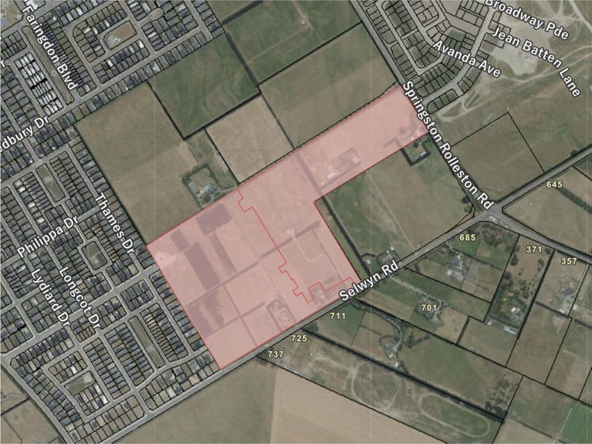
Hughes Developments Limited/ Faringdon South East and South West/ 20184

Table of Contents
1.   A description of the proposed activity (clause 9(1)(a)) ........................................................................ 1
     1.1      Overview .................................................................................................................................. 1
     1.2      Subdivision ............................................................................................................................... 4
     1.3      Supporting Activities ................................................................................................................ 7
     1.4      Overall Design Approach ....................................................................................................... 11
     1.5      Landscaping ........................................................................................................................... 14
     1.6      Traffic ..................................................................................................................................... 14
     1.7      Infrastructure ......................................................................................................................... 15
     1.8      Geotechnical .......................................................................................................................... 21
     1.9      Conclusion.............................................................................................................................. 21
2.   A description and map of the site at which the activity is to occur (clause 9(1)(b)) .......................... 22
     2.1      South East .............................................................................................................................. 22
     2.2      South West............................................................................................................................. 23
3.   Confirmation that the consent application complies with clause 3(1) (clause 9(1)(c)) ..................... 23
4.   Owner and occupier information (clause 9(1)(d)) .............................................................................. 23
     4.1      South East .............................................................................................................................. 24
     4.2      South West............................................................................................................................. 24
5.   A description of any other activities that are part of the proposal to which the application relates
     (clause 9(1)(e)) .................................................................................................................................... 24
     5.1      Stormwater discharges and construction related earthworks .............................................. 24
     5.2      National Environmental Standard for Assessing and Managing Contaminants in Soil to
     Protect Human Health ........................................................................................................................ 25
6.   A description of any other resource consents, notices of requirement for designations, or
     alterations to designations Clause 9(1)(f)........................................................................................... 25
7.   An assessment of the activity against Clause 9(1)(g) ......................................................................... 25
     7.1      Part 2 of the RMA .................................................................................................................. 25
     7.2      The purpose of the Act .......................................................................................................... 27
     7.3      The matters set out in section 19 of the Act ......................................................................... 28
8.   An assessment of the activity against relevant planning documents - Clause 9(1)(h), 9(2) and (3) .. 31
     8.1      National Policy Statement Urban Development 2020 (NPS-UD)........................................... 31
     8.2      National Policy Statement for Freshwater Management 2020 (NPS-FM)............................. 35
     8.3      National Environmental Standard for Freshwater Regulations 2020 (NPS-F) ....................... 35
     8.4      National Environmental Standard for Assessing and Managing Contamination in Soil to
     Protect Human Health 2011 (NES-CS) ................................................................................................ 36
     8.5      Canterbury Regional Policy Statement 2013 (CRPS) ............................................................. 37
     8.6      Canterbury Land and Water Regional Plan (CLWRP) ............................................................. 41
     8.7      Canterbury Air Regional Plan (CARP) ..................................................................................... 41
     8.8      Selwyn District Plan ............................................................................................................... 41
     8.9      Selwyn District Plan Objective and Policy Assessment .......................................................... 53
     8.10 Proposed Selwyn District Plan ............................................................................................... 56
     8.11 District Plan and Proposed Plan Objectives and Policies Assessment Conclusion ................ 58
     8.12 Iwi Management Plan ............................................................................................................ 59

                                                                                                                                                          i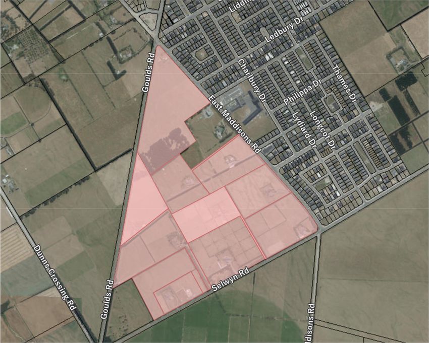
Hughes Developments Limited/ Faringdon South East and South West/ 20184

      8.13 Conclusion.............................................................................................................................. 62
9.    Information about any Treaty settlements that apply in the project area, including…(clause 9(1)(i))
       ............................................................................................................................................................ 63
      9.1          The identification of the relevant provisions in those Treaty Settlements. .......................... 63
      9.2          A summary of any redress provided by those settlements that affects natural and physical
      resources relevant to the project or the project area. ....................................................................... 63
10.   The conditions that the applicant proposes for the resource consent (clause 9(1)(j)) ...................... 63
11.   An assessment of the activity’s effects on the environment (clause 9(4)) ........................................ 63
      11.1 An assessment of the actual or potential effects on the environment (clause 10(1)(a)) ...... 63
      11.2 If the activity includes the use of hazardous installations, an assessment of any risks to the
      environment that are likely to arise (clause 10(1)(b)) ........................................................................ 72
      11.3 If the activity includes the discharge of any contaminant, a description of the nature of the
      discharge and the sensitivity of the receiving environment to adverse effects and any possible
      alternative methods of discharge, including discharge into any other receiving environment (clause
      10(1)(c)) .............................................................................................................................................. 72
      11.4 A description of the mitigation measures (including safeguards and contingency plans
      where relevant) to be undertaken to help prevent or reduce the actual or potential effect of the
      activity (clause 10(1)(d)). .................................................................................................................... 72
      11.5 Identification of persons who may be affected by the activity and any response to the views
      of any persons consulted, including the views of iwi or hapū that have been consulted in relation to
      the proposal. If iwi or hapū elect not to respond when consulted on the proposal, any reasons that
      they have specified for that decision (clauses 10(1)(e) and (f)). ........................................................ 73
      11.6 If the scale and significance of the activity’s effects are such that monitoring is required, a
      description of how the effects will be monitored and by whom, if the activity is approved (clause
      10(1)(g)). ............................................................................................................................................. 74
      11.7 An assessment of any effects of the activity on the exercise of a protected customary right
      (clause 10(1)(h)). ................................................................................................................................. 74
      11.8 An assessment of additional effects and matters (clause 11) ............................................... 74
      11.9 Overall conclusion regarding effects ..................................................................................... 76
12.   Cultural Impact Assessment (clause 9(5)) .......................................................................................... 76
13.   A consent application must also include (clause 9(6)) ....................................................................... 76
      13.1 Permitted activity description (clause 9(6)(a) ....................................................................... 76
      13.2 Marine and Coastal Area (Takutai Moana) Act 2011 Assessment (clause 9(6)(b)) ............... 78
      13.3 All additional information required by the relevant project order ....................................... 78
      13.4 Information required in applications for subdivision (clause 12(1) and (2)) ......................... 78

Appendices
A.    Subdivision Plans
B.    Selwyn District Council Conditions
C.    Erosion and Sediment Control Plans
D.    Traffic Assessment
E.    Urban Design Assessment
F.    Landscaping Plans
G.    Infrastructure Reports
H.    Stormwater Assessment
I.    Geotechnical Reports

                                                                                                                                                                  ii
Hughes Developments Limited/ Faringdon South East and South West/ 20184

J.   Record of Titles
K.   Owner / Occupier List and Letter
L.   Comprehensive Residential Development Plans
M.   Regional Applications
N.   Contamination Reports
O.   Economics Assessment
P.   Cultural Values Report and Correspondence with Mahaanui Kurataiao
Q.   Movement Network Plan
R.   Emissions Report
S.   Referral Application

                                                                                                                  iii
Hughes Developments Limited/ Faringdon South East and South West/ 20184
1. A description of the proposed activity (clause 9(1)(a))
1.1 Overview
Hughes Development Limited (HDL) applies for resource consent to subdivide and develop two sites in
Rolleston, Selwyn for housing, namely:
Faringdon South East, which is proposed to accommodate 289 residential lots, a Neighbourhood
Centre, and associated infrastructure and amenities; and
Faringdon South West, which will accommodate 681 residential lots, a Neighbourhood Centre, and
associated infrastructure and amenities.
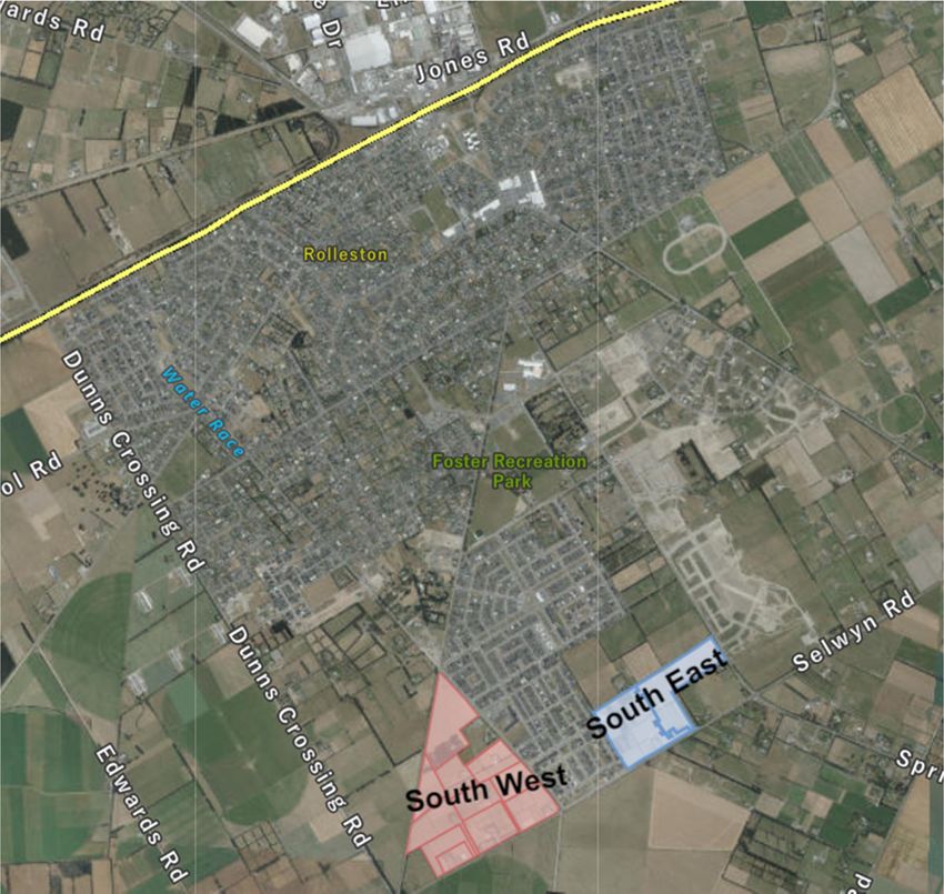
Faringdon South East and South West are located at the south western end of Rolleston. The two sites are an
extension of the existing Faringdon development, part of which (Faringdon South) was consented under the
Housing Accords and Special Housing Areas Act 2013 (HAASHA) in 2015.
Figure 1: Location of Faringdon South East and South West in context of Rolleston. Source: Canterbury Maps
The South East development area is located on the corner of Springston Rolleston Road and Selwyn Road,
Rolleston (shown in pink on Figure 2 below). It has a total land area of approximately 24.9783 hectares.
1Hughes Developments Limited/ Faringdon South East and South West/ 20184
Figure 2: South East site and surrounding environment. Source: Canterbury Maps
The South West site encompasses all except two properties within the triangular area defined by East
Maddisons Road, Goulds Road and Selwyn Road in Rolleston, as shown on Figure 3 below.
Figure 3: South West site and surrounding environment. Source: Canterbury Maps
The development will be a continuation of the well-established Faringdon residential neighbourhood which
was first developed in Rolleston in 2013. Both the South East and South West sites (together, the Project) were
approved as a referred project by the Minister for the Environment under the Covid-19 Recovery (Fast-track
Consenting) Act 2020.
In addition to contributing a significant increase in housing supply, the Project will deliver a well-functioning
urban environment characterised by a mix of residential densities and typologies, high quality landscaping and
2Hughes Developments Limited/ Faringdon South East and South West/ 20184
a network of transport links (including shared cycle and pedestrian footpaths) which connect the new areas of
housing to recreation reserves, the existing Faringdon communities and the Rolleston town centre.
The South East development includes a large centrally located recreation reserve which is a continuation of the
existing Faringdon reserve network. Generous reserve areas have been incorporated into the design of
Northmoor Boulevard to provide a spacious and quality spine to the development. The Boulevard treatment
also creates a prominent gateway entrance to the site from Springston Rolleston Road which is further defined
by the Neighbourhood Centre (commercial) and the comprehensive residential development located either
side of the Boulevard entrance (refer Subdivision Plans attached as Appendix A).
The South West development includes a continuation of the Boulevard treatment established in the South East
development. As with South East, the South West development includes a Neighbourhood Centre
(commercial) occupying a prominent site at the entrance to the development (refer Subdivision Plans at
Appendix A). A series of medium density lots served by rear lane access overlook the neighbourhood centre.
The sites are set back and separated from the Boulevard by a generous landscaped area within the road
reserve.
HDL has worked closely with the Selwyn District Council (Council or SDC) to ensure all infrastructure design
accords with its water, wastewater and stormwater network requirements. The upgrade of Springston
Rolleston Road, East Maddisons Road, Goulds Road and Selwyn Road carriageways and berms to urban
standards (including the removal of power poles and undergrounding of power lines) provides a consistent
level of treatment to these arterial and collector routes. Land from the South East site has previously been set
aside for a future upgrade of the Springston Rolleston Road – Selwyn Road intersection, which will be
undertaken by Council. Within the South West the re-alignment of East Maddisons Road will occur as part of a
Council Long Term Plan to upgrade the Goulds Road, East Maddisons Road (and Shillingford Boulevard)
intersection.
Although the Project area is currently zoned Rural Inner Plains zone in the operative Selwyn District Plan
(District Plan), as described in the Referred Project Application both sites have been identified as suitable
areas for the accommodation of additional – and much needed – residential capacity in the Selwyn district
(and particularly in Rolleston). Proposed changes to the relevant Resource Management Act 1991 (RMA)
documents are currently underway to reflect that classification. These changes are discussed in further
detail in Section 8 of this application.
In recognition of the urgent need for housing in this area however (as evidenced in part by 4,500
registrations of interest in the South West development), non-complying resource consents are being
sought under the existing zoning and in advance of those proposed zoning changes to accelerate the
delivery of residential development capacity and the provision of employment resulting from delivery of
this Project.
Adopting the same approach used under the HAASHA, those resource consents will, by way of conditions,
enable the Project to proceed in accordance with the commensurate Living Z and Business zone standards
in the District Plan. In addition to the conditions, alignment of the Project with those standards will be
secured through consent notices to be placed on each of the created lots. A copy of the proposed
conditions and consent notices are attached as Appendix B.
In that context, this application therefore seeks resource consents for the two main components of the Project:
Subdivision of both South East and South West to create lots for residential development.
Supporting activities which will facilitate the development, including earthworks, construction of the
dwellings, the comprehensive residential development, and the neighbourhood centres, and
infrastructure.
3Hughes Developments Limited/ Faringdon South East and South West/ 20184
These components are described in further detail in Sections 1.2 and 1.3.
Consents are required for these components due to various non-compliances with the operative District Plan.
An assessment of these activities against the relevant rules, objectives and policies of the District Plan is set out
in Section 8 of this application.
Consents are also required under the Canterbury Land and Water Regional Plan (CLWRP) to authorise the
proposed discharge of construction and operational phase stormwater, and earthworks. These activities and an
assessment of them against the relevant provisions of the CLWRP are also set out in Section 8 and Appendix M.
Finally, consents are sought under the National Environment Standard for Assessing and Managing
Contaminants in Soil for the Protection of Human Health (NES – CS) for the change of land use. The
assessment of this activity is also set out in Section 8.
1.2 Subdivision
1.2.1 South East
As set out in the proposed plan of subdivision (Appendix A) the subdivision of the South East site will
create:
289 residential allotments (including 10 lots comprising a comprehensive residential development)
that will enable delivery of a variety of low and medium density housing options;
Two lots to support the development of a Neighbourhood Centre;
Seven roads (which will vest in the Council);
Four reserves (which will vest in the Council);
Three point strips; and
Five utility (kiosk) lots.
Consistent with development in other parts of the District (and in accordance with the existing Faringdon
development), the subdivision has been designed, and is proposed to be consented in accordance with, the
relevant Living Z standards in the District Plan.
The proposed residential lots range in size from 319m2 to 2,851m2, inclusive of the Neighbourhood Centre. In
seeking to provide a range of housing options, proximity to the internal reserve network, the primary
movement networks and the Neighbourhood Centre have been the key drivers in dictating the location of the
medium density lots. The low density lots have been located around the periphery of the site as a means of
treating the rural-urban interface as well as mirroring the density of adjoining properties.
A breakdown of the lot densities and lot sizes is supplied in the table below:
Density No. of Lots Average Lot Size
2
Low 136 669.3m
2
Medium (Small Lot) 137 473.4m
2
Medium (Comprehensive) 10 354.00m
2
Neighbourhood Centre 2 2425.5m
As can be seen on Appendix A, the internal road layout is dominated by Northmoor Boulevard which
extends east-west across the site and provides linkage to the boulevard network within the existing
Faringdon development as well as to Lady Isaac Drive within adjoining Acland Park. Provision for a future
connection to Faringdon Boulevard to the north has been made and a second connection to Faringdon
South (Hurley Drive) will be provided in the second stage of the development (described further below).
4Hughes Developments Limited/ Faringdon South East and South West/ 20184
Net Density
Our Space 2018-2048: Greater Christchurch Settlement Pattern Update Whakahāngai O Te Hōrapa
Nohoanga was produced by the Greater Christchurch Partnership. The focus of the Update is how best to
accommodate housing and business land use needs in a way that integrates with transport and other
infrastructure provision, building greater community resilience, and contributing to a sustainable future for
Greater Christchurch that meets the needs and aspirations of our existing communities and future
generations.
One of the key growth issues to be addressed within Greater Christchurch is the distribution of housing
density. Previously within the Canterbury Regional Policy Statement (CRPS), net density within the Selwyn
District was set at a minimum of 10 households per hectare. In order to address short and medium term
capacity requirements the density requirement for new urban housing in Selwyn, Our Space has
recommended net density should be upwardly adjusted to achieve a minimum net density of 12
households per hectare. Given the direction provided by Our Space, HDL has designed the Project to
achieve a minimum of 12 households per hectare.
Net Density – Faringdon South East
For the purposes of calculating net density, the subject site has a gross area of 24.9783ha. A total of
1.4055ha of area allocated to stormwater treatment and the neighbourhood centre has been excluded
from the gross site area to leave a net area of 23.5847ha.
The development yields a total of 289 (residential) lots, which includes existing dwellings being retained on
large lots (Lots 82, 102 & 271). Based on the total yield and the net site area the development has a net
density of 12 households per hectare.
Staging
The subdivision of the South East is to be undertaken in seven stages. The bulk of the development will
occur within Stages 2-5.
The lots to be provided in Stages 1, 6 and 7 are slightly irregular in shape and scale in accordance with the
following:
Stage 1 consists of lots that have direct frontage to Selwyn Road. Due the undergrounding of
overhead power lines and road upgrade works currently being undertaken along Selwyn Road,
these lots will be serviced with lateral connections before the commencement of construction on
the overall site. Given that these lots will be serviced ahead of all other lots, they have been
retained within a smaller stage to allow titles to issue.
Stage 6 consists of three lots. Within this area is a community garden which currently serves the
wider Faringdon Community. The garden is being retained within this stage until such time as a
replacement garden is established elsewhere.
Stage 7 consists entirely of a comprehensive residential development which will yield 10 lots
ranging in size from 319m2 to 462m2.
1.2.2 South West
There are two overarching stages to the subdivision of the South West development. The initial subdivision
stage for the South West follows a similar path to the South East, and consists of a consolidation and
reconfiguration of the existing title structure to create 12 development lots ranging in size from 1,652m2 to
14.2319ha. It is noted that the creation of commensurate development blocks within the South East has
already been completed (under RC205769 and RC205770).
5Hughes Developments Limited/ Faringdon South East and South West/ 20184
Those 12 South West development blocks will then be further subdivided and developed across nine stages
to create residential lots ready for development. Consent is sought to authorise both the initial subdivision
stage, and the subsequent nine stages. This approach creates options for different funding models to be
employed throughout the development and aligns the staging of the development with pending
settlements of properties that are not yet within the applicant’s ownership.
As set out below, the further subdivision of Stages 1-9 will ultimately create:
681 residential allotments.
1 Neighbourhood Centre lot.
17 roads (to vest in Council).
7 reserves (to vest in Council).
Development Lot Future Stage Size (Ha) Number of Lots
Lot 2000 Stage 1 2.6320 36
Lot 2001 Stage 2 14.2319 175
Lot 2002 & Lot 226 Stage 3 1.3138 11
Lot 2003 Stage 4 8.7640 106
Lot 2004 Stage 5 5.4810 75
Lot 2005 Stage 6 6.3259 71
Lot 2006 Stage 7 3.4465 41
Lot 2007 Stage 8 9.5259 126
Lot 2008 Stage 9 2.2558 32
Lot 2009 Stage 1 0.3063 6
Lot 2010 Stage 1 0.1652 3
As with the South East, the subdivision of the development lots (created by the initial stage) has been
designed, and is proposed to be consented in accordance with, the relevant Living Z standards in the
District Plan.
The proposed lots range in size from 400m2 to 5,723m2 (inclusive of the Neighbourhood Centre). A similar
approach to that proposed for the South East subdivision has been adopted to the location of lots, with the low
density lots located around the periphery of the site where there is rural land adjacent to the development
area and medium density development located along main transport routes, in close proximity to the
Neighbourhood Centre and the reserve network. A breakdown of the lot densities and lot sizes is supplied in
the table below:
Density No. of Lots Average Lot Size
2
Low 298 669.3m
2
Medium (Small Lot) 383 487.95m
2
Neighbourhood Centre 1 5723m
Subdivision plans (including development lots, staging and further subdivision) are attached as Appendix A.
Net Density – Faringdon South West
For the purposes of calculating net density, the South West development has a gross area of 54.4441ha. A
total of 1.0038ha has been allocated for stormwater treatment and for the Neighbourhood Centre. As a
result, the net site area of South West is 53.4403ha.
6Hughes Developments Limited/ Faringdon South East and South West/ 20184
The South West development yields 681 lots including existing dwellings that are being retained on larger
lots. Based on the yield and net site area, the South West development has a net density of 12.74
households per hectare.
1.3 Supporting Activities
As set out in further detail below, alongside the subdivision of the sites, consents are sought for the
following activities:
Earthworks
Transport activities including right of ways, vehicle crossings, intersection separations.
The establishment of dwelling units on all residential lots (including the comprehensive medium
density residential development to be delivered in Stage 7 of South East), subject to the applicable
District Plan Living Z standards.
The establishment of two Neighbourhood Centres, subject to the applicable District Plan Business 1
standards.
The progression of construction of the dwellings after a section 223 certification has been obtained but
prior to the issue of a section 224c certification. This is necessary due to the existing District Plan
provisions that require dwellings to be located on their own, separately saleable allotment, and due to
the Plan’s density requirement of 1 dwelling per 4ha in the Rural Inner Plains zone.
1.3.1 Earthworks
Construction of the residential development within the South East area (24.9783ha) will require earthworks
of approximately 70,000m3. The South West project area has a project area of 54.4441ha and will require
earthworks of approximately 130,000m3.
During the earthworks phase of construction all topsoil on site will be retained and replaced on the land
immediately following bulk earthworks. All disturbed topsoil will be sown with Council specification grass
seed mixes. A balance of cut and fill will be maintained on site and removal of material from site will be
kept to a minimum. All bulk filling will be compacted in accordance with NZS 4431:1989. All fill testing will
be carried out by an independent laboratory.
Following construction additional earthworks will be carried out to level and finish sites and to ensure that
all future house sites will drain towards the street at a minimum grade of 1/500. Subject to design the
house sites will be elevated above the street to facilitate drainage. The minimum elevation from the street
boundary to the building site will be 100mm and may be as high as 500mm.
Environment Canterbury’s Erosion and Sediment Control Guidelines will be followed during periods of
earthworks and dust nuisance will be kept to a minimum as per council standards. Further earthworks
detail and Erosion and Sediment Control Plans are contained in Appendix C. These requirements are
proposed as part of the suite of conditions contained in Appendix B.
1.3.2 Transport activities: right of way
The use of Right of Ways (ROWs) within the Project has been driven by a number of factors including:
Minimising the extent of roading within the development by creating greater block depth;
Irregular shaped areas created by existing (adjoining) site boundaries and the retention of existing
dwellings; and
The intention of limiting direct vehicle access to the Boulevard entrance (east) and in the vicinity of key
intersections such as East Maddisons Road – Selwyn Road and East Maddisons Road – Goulds Road.
7Hughes Developments Limited/ Faringdon South East and South West/ 20184
The District Plan provides that a ROW may only service 6 properties. The following ROWs do not comply
with all of the applicable standards under the District Plan, and therefore consent is required. A full assessment
against the relevant standards is set out in Section 8, but in summary:
South West
Lots 145-152 and Lots 153-165 will be served by ROWs that act as rear lanes, providing access to the
rear of these lots, the majority of which are medium density residential lots. Both ROWs exceed the
maximum number of lots (6) able to be served by a shared access. In addition, the ROWs are of a
length that requires a turning head and passing bays. These will not provided.
The ROW serving Lots 331 and 332 is proposed to be 4.50m which is below the legal width of 5.00m
provided in the Plan. The carriageway width will be a minimum of 3.00m. A turning area and a passing
bay are not required.
The right of way serving Lots 448 to 451 has increased in legal width from the 5.00m minimum width
to 6.50m as the ROW is over 50m in length. The carriageway width will be a minimum of
5.0m. Although a turning area and a passing bay are required, these are not provided.
The right of way serving Lots 428 to 430 and Lots 468 to 471 are required to provide a turning area and
a passing bay is required. These are not provided.
The right of way serving Lots 616 to 619 has increased in legal width from 5.00m to 6.50m as the ROW
is over 50m in length. The carriageway width will be a minimum of 5.0m. Although a turning area and
a passing bay are required, these are not provided.
Right of way serving Lots 624 to 629 has a legal width of 6.50m and a carriageway width of 5.0m. A
turning area and a passing bay are required. Although no provision for a passing bay has been made, a
turning head will be provided.
Right of way serving Lots 677 to 681 is accessed from East Maddisons Road. Legal width is required to
be at least 5m wide as the ROW is less than 50m in length. Carriageway width will be a minimum of
4.50m. A turning area is not required. A passing bay is required and is not provided for within the ROW.
South East
The right of way (ROW) serving the Stage 7 comprehensive residential development in South East
has a total length of 68.85m and serves 10 properties. Although the number of properties served
by the ROW exceeds the number (6 properties) permitted under the District Plan, the ROW
construction and characteristics mitigates any adverse effects arising from the additional properties
taking access. In particular, the ROW has a legal width of 7.0m and a formed carriageway width of
between 4.75m and 6.5m. The ROW includes parking bays and will be extensively landscaped. By
adopting shared access to the comprehensive site, access from Northmoor Boulevard and Springston
Rolleston Road can be limited. Additionally, the use of shared access to serve the comprehensive
development removes car-centric features from a prominent location which allows for a higher
standard of landscape treatment of the street scene.
1.3.3 Transport activities: vehicle crossings
South East
Vehicle crossings are typically located on the southern boundaries to make use of the natural sunlight for
both outdoor and indoor living areas.
The vehicle crossings proposed as part of the South East development follow this philosophy. However as a
result, the following lots do not comply with the relevant location standards in the District Plan as they are
will be located within the setback from an intersection or within 7m of a shared access or greater than 1m
but less than 7m from another vehicle crossing:
8Hughes Developments Limited/ Faringdon South East and South West/ 20184
Lots 1, 2, 3, 4, 5, 15, 16, 14, 18, 21, 22, 25, 31, 35, 43, 44, 49, 50, 59, 71, 91, 95, 98, 107, 108, 128,
129, 148, 149, 150, 151, 165, 166, 167, 168, 177, 183, 182, 195, 199, 211, 221, 222, 223, 224, 225,
226, 227, 228, 229, 230, 231, 246, 260, 266, 267, 268, 269, 270, 271 (existing), 272, 273, 274.
A full assessment of these crossings against these standards is set out in Section 8.
South West
For similar reasons as the South East subdivision, the following lots do not comply with the standards relating
to the minimum distances between vehicle crossings and intersections and/or the separation of vehicle
crossing from a shared accessway:
Lots 5, 6, 7, 8, 13, 14, 15, 16, 27, 28, 29, 30, 43, 44, 45, 46, 47, 50, 62, 115, 138, 139, 143, 144, 163,
164, 168, 169, 189, 216, 219, 221, 222, 257, 258, 259, 260, 274, 287, 297, 301, 302, 318, 364, 365,
387, 388, 403, 402, 420, 421, 442, 441, 445, 464, 465, 466, 473, 491, 494, 495, 496, 497, 505, 531,
532, 533, 534, 548, 578, 623, 644, 651, 652, 661, 662, 663, 664, 667, 668, 671, 673, 674.
A full assessment of these crossings against these standards is set out in Section 8.
1.3.4 Transport activities: intersections
There are a number of instances where the required minimum intersection spacing in the District Plan is
not achieved within the South East and South West developments. There are two instances in South East
where there is a spacing shortfall of 5m. Within the South West there are nine instances where there is a
spacing shortfall. The shortfall ranges from 3m to 40m.
A full summary of each instance and an assessment of the shortfall are included in the Integrated Traffic
Assessment which is contained in Appendix D.
1.3.5 Dwellings
Due to the underlying Rural zoning of the sites, land use consent is necessary to enable the establishment
of dwellings on the South West and South East allotments. As noted, it is proposed to manage the
establishment of dwellings on all the allotments through the imposition of a suite of design conditions
derived from the Living Z standards within the Township Section and Appendix 13 of the District Plan.
The conditions for each of the different densities are based on the following:
Low Density Lots Living Z rules
Medium Density Lots Living Z Medium Small Lot rules
Compliance with the land use consent will be required through a Consent Notice on the title of the individual
allotments created. The Consent Notice will identify that future building activity needs to be in accordance
with the Living Z standards and will inform purchasers of what District Plan standards apply when designing
their dwellings. A copy of the proposed conditions and Consent Notices is attached as Appendix B.
Due to the underlying Rural Inner Plains zoning of the Project area, any residential development on individual
lots that do not fully comply with Living Z rules (as required by the consent notices and conditions) will require
additional resource consent for any non-compliance and any such application will be assessed as a non-
complying activity. This approach was successfully used under the HAASHA to accelerate the delivery of
housing ahead of anticipated changes to the planning documents and is well understood by both the applicant
and the Council.
9Hughes Developments Limited/ Faringdon South East and South West/ 20184
1.3.6 South East Small Lot Medium Density (Comprehensive) Development
Stage 7 of the South East development will enable the establishment of a comprehensive residential
development, comprising 10 dwelling units proposed to be located on lots ranging in size from 319m2 to
462m2.
The units are to be accessed off a shared ROW and are subject to an extensive landscaping plan which
encompasses the private-public interface, shared space within the ROW and private internal landscaping within
each lot. A full set of dwelling designs and landscaping plans are provided as Appendix F.
The underlying Rural zone also makes it necessary to apply for land use consent to enable the establishment of
this development. The conditions proposed to apply to this consent similarly derive from the applicable Living Z
standards within the Township Section 4 of the District Plan.
1.3.7 Neighbourhood Centres
Neighbourhood centres are proposed for Lots 275 and 276 with South East and Lot 226 within South West. As
part of delivering a well-functioning urban environment, these centres are intended to support and
compliment the residential development within South West and South East.
Again, due to the underlying Rural zoning, land use consent is necessary to enable the establishment of these
centres. Similar to the dwellings, it is proposed to manage the establishment of these centres via the
imposition of a suite of design conditions derived from the Business 1 Zone rules within the Township Section
of the District Plan secured by Consent Notices. This follows the same approach taken for other
Neighbourhood Centres within the Living Z zone under the District Plan. Rule 13.1 specifically requires these
sites to have a consent notice on the title to advise future owners that the Business 1 zone rules apply. It is
proposed that the same consent notice requirement be included for the future development of Lots 275 and
276 and Lot 226.
This approach has been effectively used previously for the Acland Park Special Housing Area and in respect of a
recently established Neighbourhood Centre within the Falcons Landing residential development that forms
part of ODP Area 11. As such, it is well understood by Council.
Draft conditions and consents notices are provided in Appendix B.
1.3.8 Advancing construction/residential density
Finally, land use consent is sought to commence the construction of show homes and residential dwellings
after s223 certification has been obtained but prior to the issue of s224c certification.
Consent is required on two fronts. Firstly, due to the District Plan requirement for density of 1 dwelling per
4ha, the construction of more than 6 dwellings (24.9783 ha / 4ha) within Faringdon South East and 13
dwellings (54.4441ha / 4ha) within Faringdon South West would trigger the need for a resource consent.
Secondly, the District Plan requirement for each dwelling to be located on a separately saleable allotment
precludes the construction of dwellings until such time as titles have issued.
The ability to construct prior to the issue of title has several advantages. Subject to consents being granted,
the lots that are proposed for South East are pre-sold indicating a significant demand for homes. Allowing
housing construction to commence prior to title allows the building process to be undertaken over a wider
timeframe than if building was restricted until the issue of title. This is particularly significant from the
perspective of building consent processing and resourcing, the availability of building supplies and
10Hughes Developments Limited/ Faringdon South East and South West/ 20184
resourcing and reducing the intensity of residential construction activity within the development site.
Further accelerating the delivery of these homes is also more in keeping with the purpose of the Act.
Construction of infrastructure within the development will be sufficiently advanced so as to adequately
service the dwellings which seek to commence construction early. A condition of consent will require that a
building location certificate is obtained for any dwelling seeking to be constructed prior to s224c
certification. Including a building location certificate, within a Building Consent application will be a
prerequisite for any application lodged prior to the issue of s224c. The building location certificate will
assist to allay concerns relating to the siting of the building and any possible boundary infringements.
1.4 Overall Design Approach
In terms of urban design, the Project represents a further development of the Faringdon residential
development established nearly a decade ago by HDL.
Key design aspects that are readily identifiable within Faringdon such as the spatial treatment of the
boulevard network and a high standard of structural and soft landscaping treatment of the private-public
interface have been retained, whilst also seeking to give the South East and South West development an
identity of its own. An Urban Design assessment has been prepared for the development (Appendix E)
which sets this out in further detail.
In creating an identity for South East and South West, the design rationale has been informed by a desire to
give credence to the following:
Promoting place-making and identity
Prioritising walking and cycling
Internal and external connectivity
Lifestyle choice and wellbeing
Ngāi Tahu subdivision and development guidelines
Promoting Place-making, Community and Neighbourhood Identity
The inclusion of the neighbourhood centres and central reserves supports the intention to promote social
interaction and create a community focal point. The neighbourhood centres are located on the corners of
Northmoor Boulevard and Springston Rolleston Road and East Maddisons Road. These roads are primary
collectors which connect the sites directly to the centre of Rolleston. The neighbourhood centres are
therefore ideally located to take advantage of high visibility and greater passing traffic volumes as well as
function as a gateway to the development areas.
The reserves are centrally embedded amidst the residential activity, away from the busier roads which
carry through traffic. The location of the reserves is consistent with the existing Faringdon reserve network
and ensures all residents within the development area can easily access public open space on foot. The
reserves are appropriately sized to enable and encourage a variety of active and passive recreational
activities.
Prioritising walking and cycling
Like the wider Rolleston area, Faringdon is flat and ideal for active transport modes. Providing dedicated
walking and cycling infrastructure that is safe and has high amenity encourages the adoption of walking and
cycling for both recreation, neighbourhood trips and trips further afield. Higher rates of walking and cycling
have multiple benefits for both the local community and the general environment by improving physical
and mental health, improving amenity and safety of movement corridors and reducing vehicle emissions
and energy use.
11Hughes Developments Limited/ Faringdon South East and South West/ 20184
The layout facilitates high levels of walking and cycling through the provision of:
direct routes along desire lines to key destinations;
safe routes which do not conflict with vehicles and enjoy passive surveillance from adjacent activities;
visually interesting streetscapes with passive surveillance.
As outlined in the Urban Design Report (Appendix E) the development promotes active transport modes
through the adoption of a grid pattern layout and connections to both adjacent neighbourhoods and the
town centre. Shared paths (pedestrians and cyclists) are provided on primary roads to link the main
collector routes and enable commuter or longer distance cyclists easy access to the wider area. In addition,
a shared path connects the local open spaces and clusters of medium density housing together, and in turn
provides easy access out to surrounding primary roads.
Lifestyle choice and wellbeing
A range of section sizes and housing typologies provides future residents with choice and promotes a mixed
community demographic, along with a range of price points, including more affordable options. Medium
density housing (including a comprehensive residential development) is co-located with open spaces or the
neighbourhood centre to provide those residents with additional opportunity for outlook, active and
passive recreation as well as some spatial relief.
Movement and Connectivity
The layout establishes a grid-based movement network and block sizes which maximizes choice of routes
and reduces travel distances. Primary movement corridors connect the development area to the adjacent
Faringdon South, and development to the north. Northmoor Boulevard is a primary connector between
Springston Rolleston Road and East Maddisons Road, providing higher order connection beyond the site,
distributing traffic and ensuring efficiency of movement and reducing travel times.
The alignment of Northmoor Boulevard as it crosses the South East development area includes some
horizontal deflection and variation in the depth of the block to the north. This is due to two factors, namely
the desire to retain an existing dwelling located within the direct alignment as well as the need to align with
the intersection of Northmoor Boulevard and Lady Isaac Drive to the east. This results in a curve in the road
alignment which adds interest to this development and potentially slows traffic.
Future connectivity is also anticipated and provided for through the provision of two intersections with
Northmoor Boulevard, along with stub roads extending to the northern boundary of the development area.
These will allow for the continuation of Faringdon Boulevard and Hungerford Drive once the intervening
rural land is zoned and developed.
Northmoor Boulevard extends into the South West development area from the Faringdon South residential
development. The alignment of the Boulevard curves upwards to the north to achieve a perpendicular
intersection with Goulds Road. The curvature in the road provides further interest to the Boulevard route
as it traverses the South West area. The curvature also highlights the large central reserve which is located
close to the point where the boulevard starts to deviate from its alignment. The reserve acts as a gateway
feature at the western-end of the boulevard similar to the gateway feature provided by the neighbourhood
centre at the eastern entrance to the site.
Block Layout
Adopting blocks which have a predominantly north –south orientation is a sound urban design technique to
maximize solar access for dwellings and minimize the number of north facing sections (where private
12Hughes Developments Limited/ Faringdon South East and South West/ 20184
outdoor space is shaded if located at the rear). This principle however, has to be balanced with other
necessary responses, including the need to minimize road intersections on collector roads and make
efficient use of the land resource and lot geometry. The subdivision design adopts north-south blocks
where practical, while including east-west blocks in the southern portion primarily to limit the number of
intersections to Selwyn Road.
Density Distribution
It is common and best practice urban design to locate ‘density around amenity’. In this instance it directs
the location of medium density housing around neighbourhood reserves, along with a small pocket of
higher density opposite the Neighbourhood Centre.
The benefits of this practice include:
the public open space compensates for smaller rear yards and reduced recreation opportunity on
adjacent more compact housing typologies/sections;
there are higher numbers of dwellings surrounding open spaces which promotes their active use,
making better use of the land resource and more easily justifying investment and maintenance costs;
higher numbers of dwellings around reserves increases levels of active and passive surveillance of the
reserve, increasing real and perceived public safety;
dwellings located closer together (and potentially higher) improves the spatial definition of the
reserves, better defining their edges and helping to provide shelter for users and vegetation;
neighbourhood parks provide additional opportunity for on-street parking to support adjacent medium
density housing which can have less parking provision on the streets due to both the typical width of
these streets and the proximity of driveway crossings etc.
Whilst ‘density around amenity’ is a strong determination of the location of medium/higher density
residential typologies, it is not the only justification for the identification of medium density housing in
attractive residential neighbourhoods. Other drivers for the inclusion of medium density clusters include
the better use of the land resource, wayfinding/legibility and visual interest in the streetscape. Adopting
this approach also enables the Regional Policy Statement’s minimum net density of 12 hh/ha to be
achieved.
The development also contains areas of medium density that are not directly adjoining or in very close
proximity to public open spaces. As an example, pockets of medium density are located along both
Faringdon Boulevard and Northmoor Boulevard where they have the dual benefit of making good use of
deep blocks, as well as adding variety, prominence and interest to long Boulevard roads which are key
connectors. The width and landscape treatment of these Boulevard roads spatially compliments medium
density housing in a similar way to recreation reserves.
Ngāi Tahu subdivision and development guidelines
The design of the development has also been shaped by the Ngāi Tahu subdivision and development
guidelines. This is demonstrated in detailed in Section 8 of this report and includes:
The Project Area does not contain any sites of significance;
Appropriate erosion and sediment control methods will be in place during construction;
The discharge of stormwater is to ground and will not be from contaminated sites;
Accidental discovery protocol conditions are proposed in Appendix B;
The development has been carefully designed to enable dwellings to be positioned on site to
provide passive solar gain, particularly for outdoor and indoor living areas;
Landscaping of reserves will include some native vegetation.
13Hughes Developments Limited/ Faringdon South East and South West/ 20184
1.5 Landscaping
A complete set of landscaping plans for South East and South West is provided as Appendix F.
1.5.1 South East
The development will continue to use successful landscape elements from the current Faringdon network to
ensure it is cohesive with all previous stages.
New recreational networks through the development such as cycle and running trails along Northmoor
Boulevard will provide the community with more outdoor amenities offering a healthier lifestyle for people
living in the development and surrounding Faringdon stages. A range of new high-quality shared spaces will
also enable the community to come together and socialise within the reserves, potential bus stop and
community garden. These shared spaces will offer passive and active recreation opportunities for a wide range
of ages. Providing these high-quality shared spaces is important for encouraging a sense of ownership and
pride amongst the development’s residents. Fencing styles, planting and variations in site levels will balance
the need for privacy with the requirement for surveillance over shared spaces to create a safe environment.
Much of the development has been designed with many of the existing materials and plant species found in
previous Faringdon stages. This continuation of the hard and soft material palette from the wider Faringdon
network will create consistency and way finding within Faringdon. Small variations within the material and
planting palette will however offer legibility amongst this development.
1.5.2 South West
The South West development will introduce complementary but new landscape elements to the Faringdon
development palette. A distinct character will be created through various new reserve spaces, laneways, right
of ways and streetscapes. Planting, pedestrian nodes and fitness equipment will act as key wayfinding
elements throughout the development adding variety and interest to the development. In particular, a number
of new recreational networks through the development will provide the community with more outdoor
amenities such as fitness equipment, running trails and balance-park, which offer a healthier lifestyle and sense
of fun for people living in the development and surrounding Faringdon communities.
A variety of new opportunities within the landscape realm are proposed for this development with many
points of difference.
South West has been designed with a new range of modern materials which provides a fresh new identity
within the wider Faringdon network. Materials such as brick, bag-washed concrete, perforated steel and
recycled timbers will help to create a development with shared spaces that feel like an extension of the
resident’s homes.
Planting within the development will continue to use key plant species which thrive in the Rolleston
environment whilst also introducing new plant species like Sedum and Copper Beech trees which will add
subtle points of difference to previous Faringdon developments and enhance the identity of South West.
1.6 Traffic
A full Integrated Transport Assessment (ITA) is provided as Appendix D.
14Hughes Developments Limited/ Faringdon South East and South West/ 20184
1.6.1 South East and South West
Utilising the Council’s microsimulation model for the Rolleston area, the ITA shows that traffic generation from
South East and South West remain relatively modest even with development of all existing ODP areas factored
into the model. As the transportation model includes the future land uses in the area, and assigns the likely
traffic generation of these onto the surrounding road network, it reflects the most likely scenario for
development in the Rolleston area, and as such is considered to be robust.
The South East and South West development areas represent an extension to the urban area of Rolleston, and
as a result, are proximate to existing employment and community facilities. Given this a rate of 8 vehicle
movements per day per residence was considered appropriate.
The microsimulation model has also been used to determine trip distribution, which on average shows:
Towards State Highway 1 east: 9%
Selwyn Road east: 11%
Springston-Rolleston Road: 8%
State Highway 1 west: 1%
North of State Highway 1: 3%
Rolleston town centre: 9%
Other locations outside Rolleston (unspecified): 18%
Internal movements: 41%
Using the trip distribution and traffic generation data, the effects on nearby intersections has been assessed.
The assessment concludes that the extent of traffic increase through the Selwyn Road/Goulds Road
intersection will be very low and that while the increase in queues and delays is greatest at the Selwyn Road /
Springston-Rolleston Road intersection, but the levels of service remain good for a weekday peak hour.
While not in the control of the applicant, it is also expected that the Council may take the opportunity taken to
reduce the speed limits of Goulds Road and Selwyn Road, and potentially also Springston-Rolleston Road as a
result of the increased urbanisation. In each case, it would be appropriate for the current 80km/h speed limit
to be lowered to 60km/h, to be consistent with East Maddisons Road and the existing section of Selwyn Road
adjacent to Faringdon South.
1.7 Infrastructure
1.7.1 South East
The subject site and surrounding area falls towards the south at an approximate grade of 1 in 250. The land
was historically comprised of a number of lifestyle blocks of varying sizes. Accordingly, clearance of fence-lines,
shelterbelts and site improvements ranging from sheds of varying descriptions through to old dwellings that
are not being retained is required prior to the commencement of construction. It is also proposed to retain
three existing dwellings within the development area; these will be placed within new lots and supplied with all
necessary services during the development works.
Davie Lovell-Smith Ltd (DLS) has held several meetings with Strategic Planners and Infrastructure Engineers at
the Council, primarily Murray England with specific regard to servicing the proposal for water supply and
sewer, and Andrew Mazey regarding upgrading of the surrounding road network. It is HDL’s intention to
construct infrastructure that will meet the demands of this Project and also complement the long-term
requirements of the remaining undeveloped land located between the southern extent of Rolleston’s urban
boundary and the Projected Infrastructure Boundary in Map A of the CRPS.
The new infrastructure will be integrated into the existing networks and all efforts will be made to ensure that
the installations are complementary to the current assets. Infrastructure will also be provided for the future
15You can also read