STAFF REPORT - eServices of Prince William County, Virginia
←
→
Page content transcription
If your browser does not render page correctly, please read the page content below
Planning Office
Rebecca Horner, AICP, CZA
Acting Director of Planning
STAFF REPORT
PC Meeting Date: November 3, 2021
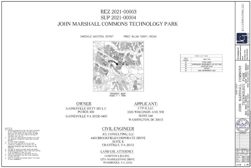
Agenda Title: Rezoning #REZ2021-00003, John Marshall Commons Tech Park
Special Use Permit #SUP2021-00004, John Marshall Commons Tech Park
District Impact: Gainesville Magisterial District
Requested Action: Recommend Approval of Rezoning #REZ2021-00003, John Marshall
Commons Tech Park, subject to proffers dated October 21, 2021, and
Special Use Permit #SUP2021-00004, John Marshall Commons Tech Park,
subject to conditions dated September 8, 2021
Department: Planning Office
Case Planner: Scott F. Meyer
EXECUTIVE SUMMARY
This is a request to rezone ±22.72 acres from B-1, General Business, and M-2, Light Industrial, to
O(M), Office Mid-Rise, for the purpose of developing a data center campus. There is a concurrent
special use permit request to allow for data center uses outside of the Data Center Opportunity
Zone Overlay District. The subject property is located to the south of Interstate 66, at the
northwestern intersection of Catharpin Road and John Marshall Highway (Route 55).
It is the recommendation of staff that the Planning Commission recommend approval of Rezoning,
#REZ2021-00003, John Marshall Commons Tech Park, subject to the proffers dated October 21,
2021, and Special Use Permit #SUP2021-00004, John Marshall Commons Tech Park, subject to the
conditions dated September 8, 2021.
5 County Complex Court, Suite 210, Prince William, Virginia 22192 • 703-792-7615 • fax 703-792-4401 | www.pwcva.gov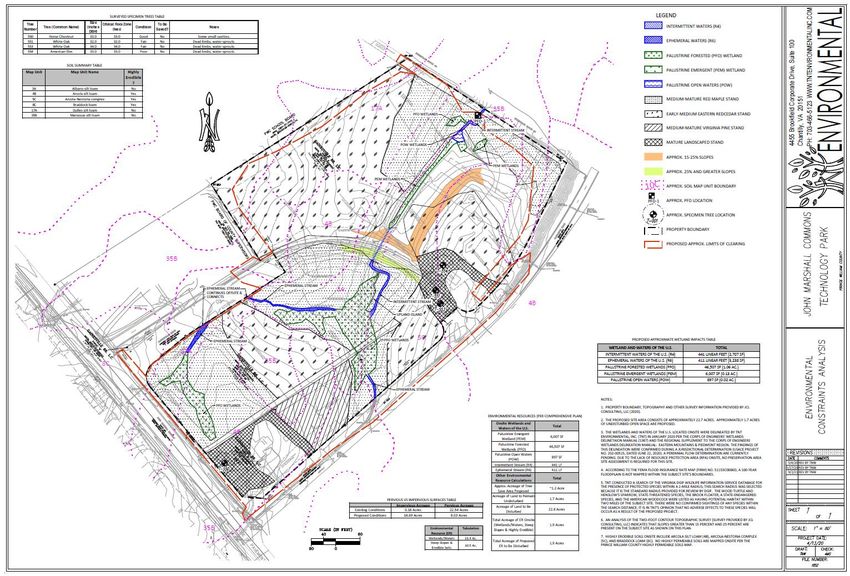
Rezoning #REZ2021-00003, John Marshall Commons Tech Park
Special Use Permit #SUP2021-00004, John Marshall Commons Tech Park
November 3, 2021
Page 2
BACKGROUND
A. Request: To rezone ±22.72 acres from B-1, General Business, and M-2, Light
Industrial, to O(M), Office Mid-Rise, for the purpose of developing a data center
campus with related uses. Concurrent with the rezoning request, there is also a
concurrent special use permit request to allow for data center uses outside of the
Data Center Opportunity Zone Overlay District.
Prior Approval Proposed
Use/Feature
(#REZ1987-0051) (#REZ2021-00003)
B-1, General Business
Zoning District O(M), Office Mid-Rise
M-2, Light Industrial
Commercial, Light Data Center with related
Use(s)
Industrial/Flex Office uses; Office Mid-Rise
Use/Feature/Parameter Allowed in O(M) Proposed
Minimum Open Space 20% 35%
Maximum Floor Area
0.65 Up to 0.65
Ratio
Maximum Building
70 feet Up to 70 feet *
Height
Approval Mechanism
Not in Data Center Overlay Special Use Permit
(Data Centers)
* The maximum building height does not include parapets and mechanical areas that are
otherwise allowed by the Zoning Ordinance to extend above 70 feet. No height
modification is being requested.
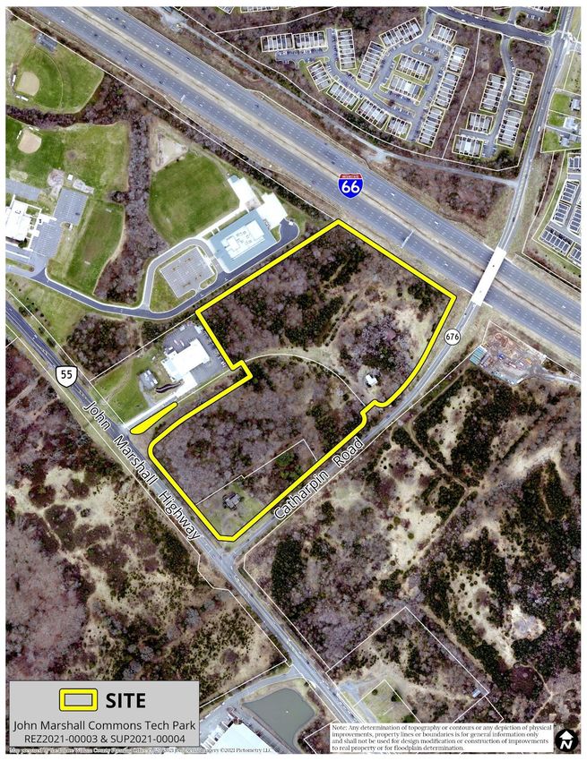
B. Site Location: The subject ±22.72-acre property is located to the south of Interstate
66, at the northwestern intersection of Catharpin Road and John Marshall Highway
(Route 55), and is identified on County maps as GPINs 7397-36-8980, 7397-46-4050,
7397-46-4281, and 7397-47-7731.
C. Comprehensive Plan: The subject site is designated CEC, Community Employment
Center, in the Comprehensive Plan, and is located within the I-66 / Route 29 Sector
Plan special planning area.
D. Zoning: The site is currently zoned B-1, General Business, and M-2, Light Industrial,
and is partially located within the Airport Safety Overlay District.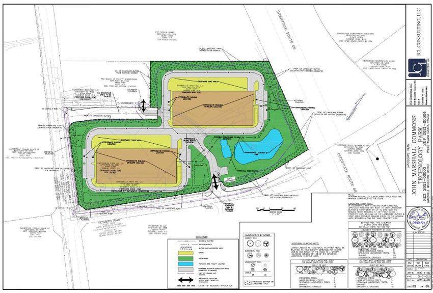
Rezoning #REZ2021-00003, John Marshall Commons Tech Park
Special Use Permit #SUP2021-00004, John Marshall Commons Tech Park
November 3, 2021
Page 3
E. Surrounding Land Uses: The site is adjacent to a mix of residential, institutional,
commercial, and industrial land uses. Surrounding uses include the following:
Interstate 66 to the north; single-family attached dwellings to the north on opposite
side of Interstate 66; vacant/undeveloped land to the east; the recently approved
Village Place technology park site to the south and southwest; and Tyler Elementary
School, Pace West School, and Prince William County Fire & Rescue Station #4 to the
west. Village Place Homeowners Association and Gainesville Business Park (a heavy
industrial use) are also nearby.
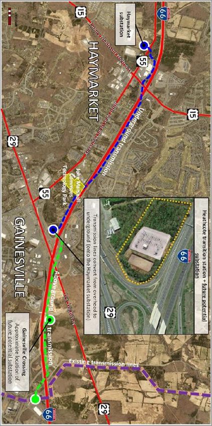
The following vicinity map exhibit has been provided by the Applicant:
F. Background and Context: The rezoning will replace the original proffered conditions
adopted as a part of the project known as John Marshall Commons (#REZ1987-0051).
The existing land entitlement permitted commercial, office, and light industrial uses.
The site is currently split-zoned as B-1, General Business, and M-2, Light Industrial.
As proposed, the O(M), Office Mid-Rise, zoning district will allow for development of
a data center campus and potential other O(M) uses. In addition to the rezoning
request, a special use permit is requested to allow data center uses, since the subject
property is not located within the Data Center Opportunity Zone Overlay District.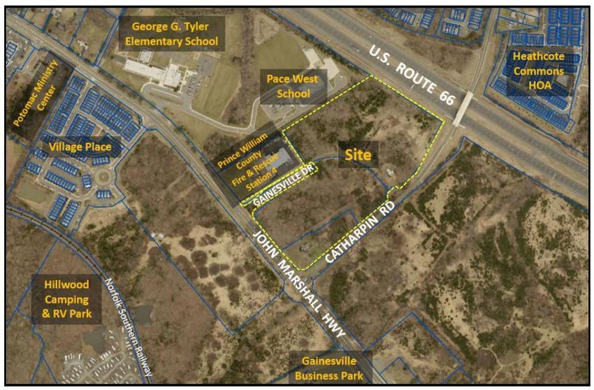
Rezoning #REZ2021-00003, John Marshall Commons Tech Park
                                    Special Use Permit #SUP2021-00004, John Marshall Commons Tech Park
                                                                                       November 3, 2021
                                                                                                Page 4

STAFF RECOMMENDATION

Staff recommends approval of Rezoning #REZ2021-00003, John Marshall Commons Tech Park,
subject to the proffers dated October 21, 2021, and Special Use Permit #SUP2021-00004, John
Marshall Commons Tech Park, subject to the conditions dated September 8, 2021, for the following
reasons:

       •   The proposed data center campus with related uses further the employment goals
           central to the CEC, Community Employment Center, use designation.

       •   The concurrent rezoning and special use permit proposals enable the delivery of a data
           center campus, which is a targeted industry use.

       •   As proffered, the project will have a specific layout, data center design features,
           landscaping enhancements/buffering, access improvements, and other use parameters
           to mitigate the impacts.

While staff recommends approval overall, staff continues to recommend that the Applicant increase
buffering and setbacks adjacent to Pace West School.

Comprehensive Plan Consistency Analysis

Long-Range Land Use: The site is designated CEC, Community Employment Center. It is also located
within the I-66/Route 29 Sector Plan special planning area. The purpose of the CEC designation is to
provide for areas of low- to mid-rise offices, research and development, lodging, and mixed-use
projects planned and developed in a comprehensive, coordinated manner. The O(M), Office Mid-
Rise, zoning district is intended to facilitate the development of a data center campus, as proffered,
and directly implements the CEC use designation. Data centers further employment goals central to
the CEC designation.

Level of Service (LOS): If the application is approved, the LOS impacts for this proposed rezoning
would be mitigated by the proffered monetary contributions, as follows:

            Water Quality            $75 per acre            ±22.72 acres           $1,704.00

            Fire & Rescue        $0.61 per square foot      Maximum 0.65          $392,409.38
                                  (SF) of building area      FAR = Up to
                                                            643,294.08 SF

               TOTAL $                                                            $394,113.38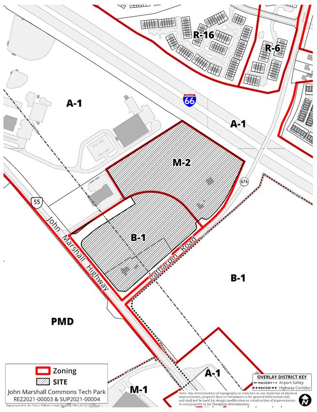
Rezoning #REZ2021-00003, John Marshall Commons Tech Park
                                     Special Use Permit #SUP2021-00004, John Marshall Commons Tech Park
                                                                                        November 3, 2021
                                                                                                 Page 5

Strategic Plan

Resilient Economy: The proposed rezoning is favorably aligned with the County’s Resilient Economy
objective to continue efforts to preserve and expand the commercial tax revenue base. The
rezoning from B-1 and M-2 to O(M) will continue to result in an increased assessed tax value and
commercial tax base, and more direct implementation of the CEC, Community Employment Center,
land use designation.

Transportation & Mobility: The proposed rezoning is favorably aligned with the County’s
Transportation & Mobility objective to improve multi-modal options by increasing sidewalk/trail
connectivity and proffering bike racks.

Community Input

Notice of the applications has been transmitted to property owners within 500 feet of the subject
site. As of the date of this staff report, the Planning Office received five (5) emails in opposition and
one (1) email in support of the project. The Planning Office also received several phone calls from
concerned citizens in the general vicinity. In summary, concerns have been expressed about
combined impacts of future data centers outside of the Overlay and expanded development within
the area.

Other Jurisdiction Comments

The site is located approximately 0.6 miles southeast of the Town of Haymarket. Each submission
has been forwarded to the Town of Haymarket for review and comment. In summary, the Town’s
comments are as follows:

    •   Significant concern for the visual impact of additional power lines to support the data center
        complex (complexes) along the Route 55 corridor leading into the Town of Haymarket.

    •   Property value concern for the residential properties that may be affected by additional
        power lines.

    •   Significant concern for the health and safety of the Town residents, schools and surrounding
        communities and the long-term impact the larger power substations, above ground and
        below ground lines will cause.

    •   Significant concern regarding the route of the additional power lines, specifically through the
        historic overlay.

    •   Interested in receiving more information on the proposed power load, proposed water
        consumption, need for additional power lines, and a proposed route for the additional lines.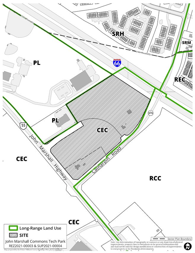
Rezoning #REZ2021-00003, John Marshall Commons Tech Park
                                   Special Use Permit #SUP2021-00004, John Marshall Commons Tech Park
                                                                                      November 3, 2021
                                                                                               Page 6

Legal Issues

If the requests are approved, the site could be developed as proffered and conditioned, for data
center uses. In the event that the request is denied, the property would be subject to the existing
proffers, as per #REZ1987-0051. Legal issues resulting from the Planning Commission’s action are
appropriately addressed by the County Attorney’s Office.

Timing

The Planning Commission has until February 1, 2022, which is 90 days from the first public hearing
date, to take action on the rezoning and special use permit proposals. A recommendation to
approve or deny the requests would meet the 90-day requirement.

STAFF CONTACT INFORMATION

Scott F. Meyer | (703) 792-6876
smeyer@pwcgov.org

ATTACHMENTS

Area Maps
Staff Analysis
Proffer Statement
SUP Conditions
Generalized Development & Special Use Permit Plan
Environmental Constraints Analysis (ECA) Exhibit
Building Elevations
Power Availability Summary Document/Exhibit (by Applicant)
Correspondence from Virginia Energy
Historical Commission Resolutions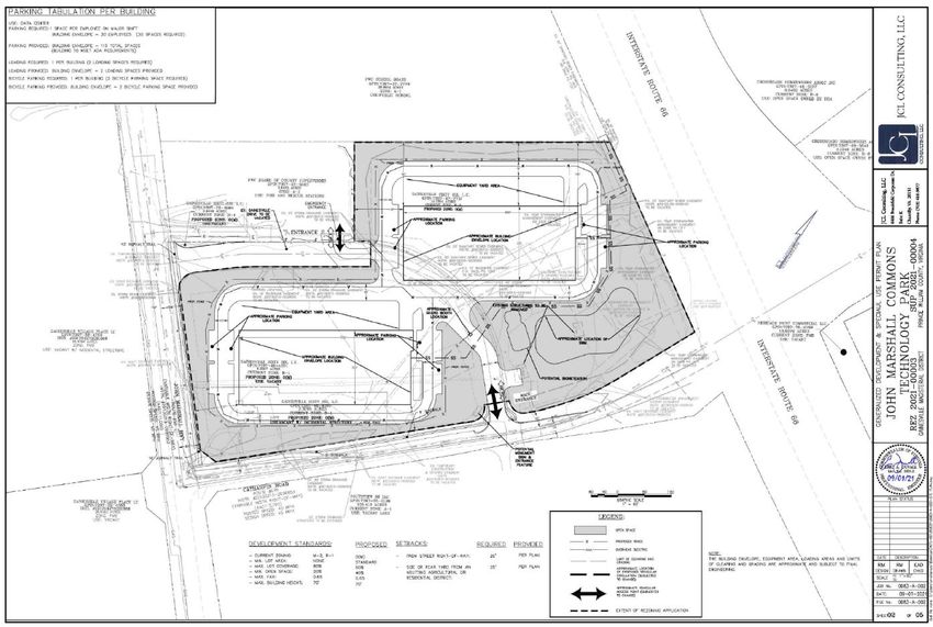
Vicinity Map

#REZ2021-00003 & #SUP2021-00004 | Page 7
Aerial Map

#REZ2021-00003 & #SUP2021-00004 | Page 8
Long Range Land Use Map

#REZ2021-00003 & #SUP2021-00004 | Page 9
Zoning Map

#REZ2021-00003 & #SUP2021-00004 | Page 10
Staff Analysis

                 Part I. Summary of Comprehensive Plan Consistency

Staff Recommendation: APPROVAL

This summary analysis is based on the relevant Comprehensive Plan action strategies, goals, and
policies. A complete analysis is provided in Part II of this report.

              Comprehensive Plan Sections                        Plan Consistency
                  Long-Range Land Use                                   Yes
                   Community Design                                     Yes
                   Cultural Resources                                   Yes
                 Economic Development                                   Yes
                      Environment                                       Yes
                    Fire and Rescue                                     Yes
                         Police                                         Yes
                     Potable Water                                      Yes
                     Sanitary Sewer                                     Yes
                     Transportation                                     Yes

                  Part II. Comprehensive Plan Consistency Analysis

The following table summarizes the area characteristics:

  Direction              Land Use              Long-Range Land Use               Zoning
                                                 Map Designation

  North         Interstate 66; High density           CEC; SRH                A-1; R-6; R-16
                suburban residential (across
                I-66)
  South         Vacant/undeveloped land;                   CEC                    PMD
                Recently approved Village
                Place technology park site
  East          Vacant/undeveloped land;                   RCC                   A-1; B-1
                Pending I-66 and Route 29
                Technology Park

  West          Pace West School; Prince                   PL                       A-1
                William County Fire &
                Rescue Station #4

                                                      #REZ2021-00003 & #SUP2021-00004| Page 11
Staff Analysis
Long-Range Land Use Plan Analysis
Through wise land use planning, the County ensures that landowners are provided a reasonable use
of their land while the County is able to judiciously use its resources to provide the services for
residents and employers’ needs. The Long-Range Land Use Plan sets out policies and action
strategies that further the County’s goal of concentrating on population, jobs, and infrastructure
within vibrant, walkable, mixed-use centers serviced by transit. In addition to delineating land uses
on the Long-Range Land Use Map, the Plan includes smart growth principles that promote a
countywide pattern of land use that encourages fiscally sound development and achieves a high-
quality living environment; promotes distinct centers of commerce and centers of community;
complements and respects our cultural and natural resources, and preserves historic landscapes
and site-specific cultural resources; provides adequate recreational, park, open space and trail
amenities that contribute to a high quality of life for county residents; and revitalizes, protects, and
preserves existing neighborhoods.
This is a request to rezone ±22.72 acres from B-1, General Business, and M-2, Light Industrial, to
O(M), Office Mid-Rise, for the purpose of developing a data center campus. There is a concurrent
special use permit request to allow for data center uses outside of the Data Center Opportunity
Zone Overlay District.
The subject property is located within the Development Area of the County and is classified CEC,
Community Employment Center, in the Comprehensive Plan. It is also in the I-66/Route 29 Sector
Plan special planning area; however, there are no specific action strategies within the I-66/Route 29
Sector Plan, Long-Range Land Use Plan, specific to the subject site. The following table summarizes
the uses and densities intended within the CEC use designation: :
Long-Range Land Use Intended Uses and Densities
Map Designation
Community The purpose of the Community Employment Center classification is to
Employment Center provide for areas of low- to mid-rise offices (including government
(CEC) offices, particularly those for Prince William County agencies),
research and development, lodging, and mixed-use projects planned
and developed in a comprehensive, coordinated manner. CEC
projects shall be located at or near the intersection of principal
arterials and major collector roads, or at commuter rail stations.
Residential uses shall be considered secondary uses and shall
represent no greater than 25 percent of the total CEC gross floor area
of the project. Drive- in/drive-through uses are discouraged. Single-
family attached or multifamily housing including elderly housing is
permitted, at a density of 6-12 units per gross acre, less the ER
designated portion of a property. Development in CEC projects shall
occur according to an infrastructure implementation plan submitted
at the time of rezoning. The intent of this plan is to ensure that critical
infrastructure for office, employment, and lodging uses is developed
#REZ2021-00003 & #SUP2021-00004| Page 12Staff Analysis
adequately for each phase of the project. Development shall also
occur according to a phasing plan that must ensure that office,
employment, and lodging uses are always the primary uses within the
area rezoned. Office development in CEC areas is encouraged to be
in accordance with the Illustrative Guidelines for Office Development,
provided as a supplement to the Community Design Plan chapter of
the Comprehensive Plan and available from the Planning Office. A
minimum office building height of 3-5 stories is preferred.
Proposal’s Strengths
• Zoning & Long-Range Land Use Compatibility: The property is currently zoned B-1, General
Business, and M-2, Light Industrial, and is designated CEC, Community Employment Center.
The proposal to rezone the property to O(M), Office Mid-Rise, will directly implement the CEC
use designation in the Comprehensive Plan. The O(M) zoning district is intended to
implement the regional employment center, regional recreation center, office, flexible use
employment center, and community employment center land use classifications of the
Comprehensive Plan. The purpose of this zoning district is to also promote employment
opportunities and to enhance the tax base of the County. The proposed O(M) zoning district
more closely implements the CEC use designation than the existing B-1/M-2 zoning, and
particularly the M-2 zoning. Data centers outside of the Data Center Opportunity Zone
Overlay District are allowed by special use permit (SUP) in the O(M) district, and an SUP has
been submitted to accompany the Applicant’s request.
• Targeted Industry: The subject application proposes data center uses. Data centers are
identified as a targeted industry group by the Board of County Supervisors. Staff notes that
the site is not located within the Data Center Opportunity Zone Overlay District, which
identifies office and industrial zoning districts in the County in which data centers are
allowed by-right. At its closest point, the Data Center Opportunity Zone Overlay District is
approximately one mile southeast of the site, on the south side of I-66. Data centers are a
permissible use outside of the overlay, subject to SUP approval.
• Retention of Non-Residential Uses: The CEC land use designation recommends that office,
employment, and lodging uses are always the primary uses. The entirety of the rezoning
area is proposed for nonresidential uses (data centers with associated offices), which are a
type of employment uses that contribute to enhancing the tax base of the County.
Proposal’s Weaknesses
• Issues with CEC Consistency: The Community Employment Center (CEC) land use
designation envisions office development with high quality architecture and building heights
ranging from three to five stories in order to maximize visibility and exposure at high profile
locations, in this instance along I-66. Data center development is not specifically a primary
recommended use within an area designated CEC, although it is a permitted use within the
O(M), Office Mid-Rise, zoning district, subject to the approval of a SUP. Data center uses
#REZ2021-00003 & #SUP2021-00004| Page 13Staff Analysis
within an area designated CEC may be considered, provided the expectations that would
otherwise be anticipated with office development, specifically high-quality architecture and
compatibility with adjoining land uses, are maintained. As noted subsequently in this report,
use compatibility and appropriate buffering remain outstanding issues.
On balance, this application is found to be consistent with the relevant components of the Long-
Range Land Use Plan.
Community Design Plan Analysis
An attractive, well-designed County will attract quality development, instill civic pride, improve the
visual character of the community and create a strong, positive image of Prince William County. The
Community Design Plan sets out policies and action strategies that further the County’s goals of
providing quality development and a quality living environment for residents, businesses and
visitors, and creating livable and attractive communities. The Plan includes recommendations
relating to building design, site layout, circulation, signage, access to transit, landscaping and
streetscaping, community open spaces, natural and cultural amenities, stormwater management,
and the preservation of environmental features.
When implemented in accordance with its intent to conveniently link businesses and residences by
coordinating employment centers with residential areas, the O(M) zoning district is an
implementation tool for the CEC designation. However, due to the nature of the use, the proposal
includes transitional setbacks, landscape buffers, berms, screening walls, architectural
enhancements, and enhanced sign features – which were prioritized by staff to limit adverse
impacts of the scale of the use on the surrounding area over design techniques that would facilitate
connectivity and continuity of development with adjoining land uses. There is also a concurrent SUP
request for data center uses.
Proposal’s Strengths
• Building Setback Thresholds: As proffered, the minimum principal building setback from
John Marshall Highway and Interstate 66 shall be 135 feet. The minimum principal building
setback from Catharpin Road shall be 75 feet. The minimum principal building setback from
the adjacent the public school property shall be 110 feet. Buildings, fences and structures
necessary for security measures, and other ancillary structures supportive of the operations
of the data center, shall be located in accordance with the minimum requirements of the
Zoning Ordinance or as proffered.
• Overall Site Coverage Commitment: As proffered, the maximum site coverage shall be 65%,
instead of the standard allowable requirement of 80%.
• Building Finishes: As proffered, the building design shall be in substantial conformance with
the Building Elevations titled, “John Marshall Commons Technology Park” prepared by
Penney Design Group and dated June 25, 2020. The Applicant shall submit the architectural
elevations to the Planning Director for review and approval for consistency with the
#REZ2021-00003 & #SUP2021-00004| Page 14Staff Analysis
architecture proposed herein a minimum of two weeks prior to the request for issuance of
the building permits for such buildings.
• Data Center Design: As proffered, principal building façades facing or visible from John
Marshall Highway and Catharpin Road shall incorporate consistent design, materials, and
details and shall avoid the use of undifferentiated surfaces by including at least two of the
following design elements. The proposed building elevations generally reflect elements of
these below standards.
o change in building height;
o building step-backs or recesses;
o fenestration;
o change in building material, pattern, texture, color; or
o use of accent materials.
• Screening of Mechanical Equipment: As proffered, ground level and roof top mechanical
equipment shall be screened from John Marshall Highway and adjacent properties.
Mechanical equipment not screened (blocked) from view as a result of its location relative to
the principal building, other structures, and/or existing vegetation or landscape buffering,
shall be screened by a visually solid fence, screen wall or panel, parapet wall, or other
visually solid screen that shall be constructed of materials compatible with those used in the
exterior construction of the principal building.
• Buffers & Landscaping: As proffered:
1. John Marshall Highway. A 30-foot buffer shall be provided along the abutting right-of-
way as shown on the GDP.
2. Catharpin Road. A 30-foot buffer shall be provided along the abutting right-of-way, as
shown on the GDP, containing a combination of natural topography and preservation of
existing vegetation having sufficient density, depth, and height, supplemented with new
plantings if deemed necessary during the final site plan review/approval process.
3. Interstate 66. A 50-foot buffer shall be provided along the abutting right-of-way as
shown on the GDP, containing a combination of natural topography and preservation of
existing vegetation having sufficient density, depth, and height, supplemented with new
plantings if deemed necessary during the final site plan review/approval process, to
provide separation and screening equivalent to Buffer Type C, as per the DCSM.
4. All plantings located within landscape areas and buffers shall consist of drought tolerant
species appropriate for the climate and location proposed and shall predominately
consist of native species in accordance with the DCSM. Where possible, existing
vegetation in landscape areas and buffers shall be preserved and incorporated into the
design and supplemented by additional plantings, as per the DCSM.
#REZ2021-00003 & #SUP2021-00004| Page 15Staff Analysis
• Fencing: As proffered, security fencing of the style and type recommended in Zoning
Ordinance section 32-509.02.4.(D), or an equivalent style and type, shall be provided where
such fencing would be visible from public or private street frontages. Chain-link fencing,
with or without slatted inserts, and/or barbed wire or other similar visible deterrence devices
shall not be permitted where visible from public or private streets.
• Orientation & Screening of Service Areas: As proffered:
1. Refuse Storage Area. Refuse collection areas, loading and service areas shall be oriented
away from John Marshall Highway and Catharpin Road, unless substantially screened
from view by landscaping and/or a screening wall or fence.
2. Electrical Gear. Electrical switch gear, electrical metering equipment, and similar
appurtenant uses, if any, shall be screened from adjacent major roads and the adjacent
public properties as follows:
o Ten-foot-tall opaque fencing facing residentially zoned/planned properties. The
Planning Director may allow for alternative compliance with this requirement,
provided the Applicant demonstrates that the need for such fencing is reduced
due to the height of the equipment being screened, placement of such
equipment relative to buildings and adjacent properties, and through
landscaping and/or other methods to reduce visibility.
o All other buffering and landscaping requirements of the DCSM shall still apply.
• Monument Sign: As proffered, a single freestanding monument style sign shall be permitted
along the Catharpin Road frontage of the site. The maximum freestanding sign height shall
be 10 feet, and the sign shall be set back a minimum of 10 feet from the public right-of-way.
Landscaping shall be provided at the base of the sign and the sign shall have a stone face.
• Exterior Lighting: As proffered, all exterior lighting fixtures shall be “energy-saving” and shall
include “focused sharp cut-off” designs that direct light downward and into the interior of
the property and away from adjacent roads and/or properties. Exterior fixtures shall be fully
shielded to prevent glare from projecting onto the adjacent residential properties.
o Freestanding Parking Lot Lights – maximum height of 20 feet, and shall be shown on
final site plans.
o Building Mounted Lighting – maximum of 30 feet in height, and shall be shown on
final site plans.
• Sound Pressure Levels: As proffered, the Applicant shall not exceed the maximum
permissible sound pressure levels as described in the Section 14-4 of the Prince William
County Code. Such levels shall be measured at the Property boundary. Security personnel,
who will be on-duty continuously, shall be responsible to communicate any sound pressure
questions or concerns to the appropriate managerial authority at the data center.
#REZ2021-00003 & #SUP2021-00004| Page 16Staff Analysis
Proposal’s Weaknesses
• Scale of Data Center Buildings: The Comprehensive Plan recommends that infill
development within established neighborhood be provided at a density, mass, height, and
intensity that conforms with those neighborhoods. The property is located proximate to
established residential neighborhoods on the north and southwest as well as a public fire
station and elementary school, immediately adjacent to the west. Staff was concerned that
due to the grading that may be required for the use, the height of the buildings may appear
higher from the roadway due to the potential finished floor elevations, which may allow the
buildings to be visible from these neighborhoods and public uses. To address the increased
building mass and mitigate any potential visual impacts, staff requested that the Applicant
step down the buildings or propose a smaller building footprint and height adjacent to
residential properties. The Applicant indicated that this was not possible, and instead
focused on revising architectural finishes to improve the appearance of the massing. While
staff can support these revisions and believes they are an improvement, the overall scale
should be considered in the context of the surrounding residential/public uses, and
appropriate mitigation, including enhanced buffers, should be considered.
• Buffering Along School & Fire Station: Over the course of the review, staff has requested
that there be increased and transitional buffering between the subject property as it abuts
the school facility and fire station uses along the northwestern/western property lines. As
currently proposed, there is a 50-foot buffer being proposed along the Pace West school site
and the eastern portion of Fire & Rescue Station #4. Although staff has requested that there
be increased buffering width at these locations, the Applicant has not provided this. Rather,
increased tree preservation within the buffer widths is being proposed to varying
extents. Along the southwestern boundary, abutting the fire station along the south portion
of Gainesville Drive, a previous 30-foot buffer has been reduced to 15 feet. Given the size
and scale of the proposed data center development, additional buffering should be
provided.
On the adjacent Village Place Technology Park project, a variable width buffer between 80-
120 feet in width was proposed to mitigate impacts of data centers on adjacent residential
uses. Additional buffer widths should be provided on the subject site adjacent to Pace West
School to screen any views of service yards and help provide a more appropriate transition
from the school to the data center buildings.
• Needed Clarification on Perimeter Landscape Buffers/Strips: As currently proposed, the
proffers indicate that the perimeter landscaping will be planted to 30-foot and 50-foot buffer
standards, while the current GDP/SUP Plan indicates “strip” and “buffer”. The nomenclature
should be rechecked. There is some ambiguity of the proffer language with regards to
planting density and how it is indicated on the GDP/SUP Plan. Also, regarding the other
buffers, there are profiles within the plans, and there are proffers that reference the DCSM.
There should be more clarifying language in the proffers that cross-references the profiles to
the proffers. This should be clarified and revised by the Applicant in order to fully resolve
this issue.
#REZ2021-00003 & #SUP2021-00004| Page 17Staff Analysis
On balance, this application is found to be consistent with the relevant components of the
Community Design Plan.
Cultural Resources Plan Analysis
Prince William County promotes the identification, evaluation, and protection of cultural resource
sites throughout the County, as well as the tourism opportunities these sites present. The Cultural
Resources Plan recommends identifying, preserving, and protecting Prince William County’s
significant historical, archaeological, architectural, and other cultural resources – including those
significant to the County’s minority communities – for the benefit of all of the County’s citizens and
visitors. To facilitate the identification and protection of known significant properties that have
cultural resource values worthy of preservation, the land use classification County Registered
Historic Site (CRHS) is used in the Comprehensive Plan. The Plan includes areas of potentially
significant known but ill-defined or suspected pre-historic sites, Civil War sites, historic viewsheds,
landscapes or areas of potential impact to important historic sites, and encourages the
identification, preservation, protection, and maintenance of all cemeteries and/or gravesites located
within the County.
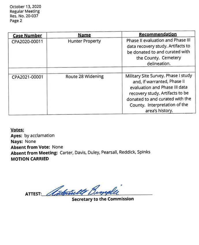
The Historical Commission initially reviewed the application package at its September 8, 2020
meeting, and recommended a Phase I study, if warranted, and Phase II evaluation and Phase III data
recovery study, as applicable. Any artifacts are to be donated to and curated with the County. At
subsequent meetings on October 13, 2020, and November 10, 2020, the item was tabled. On
December 8, 2020, the Historical Commission recommended that the Applicant revise the Phase I
report, in accord with County Archaeologist comments. Most recently, the Commission reviewed
the latest submission at its August 10, 2021 meeting, and restated for the Applicant to revise the
Phase I study (as requested previously) and submit a revised Phase I for review as soon as possible.
On September 23, 2020, the County Archaeologist submitted comments finding substantial
problems with the Phase I cultural resources study submitted with application package and did not
approve the report. The complete comments are provided in the case file, but in summary,
clarification on land ownership and a justification for the fieldwork methodology were requested. In
response to this, the Applicant recently submitted a letter with additional land ownership and
historical information and a justification of the field methodology. Based upon this additional
information, the County Archaeologist concurs with the recommendation that no further work is
needed.
At this time, the Applicant has proffered artifacts to be gifted/donated to the County, installation of
one historical marker on the property, and an updated archaeological survey to be submitted prior
to final site plan submission.
Proposal’s Strengths
• Donation of Artifacts: As proffered, artifacts collected during the Phase I Archaeological
Study shall be gifted to the County. Ownership of all records submitted to the County for
curation shall be transferred to the County with a letter of gift.
#REZ2021-00003 & #SUP2021-00004| Page 18Staff Analysis
• Historical Marker: As proffered, the Applicant shall install one (1) Historical Marker on the
property, which provides a description of the property's history. The content and design
specifications on the marker shall be prepared in consultation with the County Archaeologist
and the Historical Commission prior to final site plan approval. The location of the marker
shall be shown on the approved site plan. The historical marker shall be installed prior to
bond release.
Proposal’s Weaknesses
• None identified.
On balance, this application is found to be consistent with the relevant components of the Cultural
Resources Plan.
Economic Development
The Comprehensive Plan states the intent, goals, policies, and action strategies supporting the
Economic Development Plan for the County. The I-66/Route 29 Sector Plan incorporates the
Economic Development Plan’s intent, goals, policies, and action strategies and states additional
action strategies which apply specifically to the I-66/ Route 29 Sector Plan area.
The sector plan area has the benefit of being strategically located with direct Interstate and regional
highway routes and rail lines connecting Gainesville and Prince William County to the north, south,
east, and west. There are direct connections available to Washington, DC and the northeast
corridor, as well as to southeast metropolises via Interstate 81. Economic growth should be
promoted based on this accessibility. It should, however, also encourage desirable commercial
investment that is compatible with and supportive of a quality residential environment within the
sector plan area and nearby portions of the County and the region.
Proposal’s Strengths
• Nonresidential Development: The application proposes nonresidential development that
will increase the County’s nonresidential tax base.
• Targeted Industry: The applications would allow for the implementation of data center uses,
which are a target industry, on the subject site.
Proposal’s Weaknesses
• None identified.
On balance, this application is found to be consistent with the relevant components of the
Economic Development Plan.
#REZ2021-00003 & #SUP2021-00004| Page 19Staff Analysis
Environment Plan Analysis
Prince William County has a diverse natural environment, extending from sea level to mountain
crest. Sound environmental protection strategies will allow the natural environment to co-exist with
a vibrant, growing economy. The Environment Plan sets out policies and action strategies that
further the County’s goal of preserving, protecting and enhancing significant environmental
resources and features. The Plan includes recommendations relating to the incorporation of
environmentally sensitive development techniques, improvement of air quality, identification of
problematic soil issues, preservation of native vegetation, enhancement of surface and groundwater
quality, limitations on impervious surfaces, and the protection of significant viewsheds.
The subject site includes two old homesites with extensive forests and wetlands. There are four (4)
specimen trees, of which none are proposed to be saved.
IMPERVIOUS / PERVIOUS: 14.69 acres / 8.03 acres
RARE, THREATENED, AND ENDANGERED SPECIES: Wood turtle, Henslow Sparrow, Brook Floater and
American woodcock potential habitat. It is the consultant’s opinion that there will be no adverse
effect on these species.
SOILS:
No. Soils name Slope Erodibility
3A Albano silt loam 0-4% Slight
4B Arcola silt loam 2-7% Severe
5C Arcola-Nestoria complex 7-15% Severe
8C Braddock loam 7-15% Severe
17A Dulles silt loam 0-4% Slight
35B Manassas silt 2-7% Moderate
There is a large wetland complex onsite, of which the majority will be eliminated. Wetland impacts
will be 2,707 square feet (SF) of intermittent waters, 3,238 SF of ephemeral waters, 1.06 acres of
palustrine forested wetlands, 0.13 acres of palustrine emergent wetlands, and 0.02 acres of open
water. Some of the wetland areas were artificially created due to regrading and construction
associated with a water line extension to serve the adjacent fire station. In response to this, the
Applicant has revised the limits of clearing on the GDP/SUP Plan to preserve greater areas of forest
cover and to show additional tree preservation. With the latest submission, the proffers have been
revised to clarify the intent of tree preservation. Additional planting areas have also been added
throughout the site, which will be planted as tree canopy coverage.
Water Quality
As per standard practice, the Applicant has proffered to make a monetary contribution to the Board
of County Supervisors in the amount of $75.00 per acre for water quality monitoring, drainage
improvements, and/or stream restoration projects. Said contribution shall be made prior to and as
a condition of site plan approval with the amount to be based on the site area acreage.
#REZ2021-00003 & #SUP2021-00004| Page 20Staff Analysis
Proposal’s Strengths
• Low Impact Development (LID): As proffered, the Applicant shall provide a minimum of one
(1) Low-Impact Development (LID) Best Management Practice to treat stormwater from the
property. Such LID practice may include, but shall not be limited to, water quality swales,
bioretention facilities/rain gardens, sheet flow to vegetated buffers, or any alternative LID
practice proposed by the applicant and deemed to be acceptable to the Watershed
Management Branch.
• Tree Preservation Plan: As proffered, the Applicant shall provide a Tree Preservation Plan
(TPP) for the minimum setback areas, buffers, and undisturbed areas as shown on the
GDP/SUP Plan. The TPP shall be done in accordance with Plant Selection Guide, Section III of
the DCSM.
• Defined Limits of Clearing & Grading: As proffered, the Applicant shall develop the site in
substantial conformance with the limits of clearing and grading as shown on the GDP/SUP
Plan, subject to county review and approval, and to the extent practicable, preservation of
existing mature vegetation that is consistent with the locations of landscaped buffers and
open spaces shown on the GDP/SUP Plan and on the final site plans.
• Wetland Preservation and Mitigation: As proffered, areas identified as wetlands outside of
the limits of clearing and grading requiring preservation shall be preserved as indicated on
the GDP/SUP Plan or such impacts shall be mitigated in accordance with State and Federal
requirements.
Proposal’s Weaknesses
• Removal of All Specimen Trees: The Environment chapter of the Comprehensive Plan
recommends the preservation of natural vegetation – especially existing and mature trees,
including specimen trees. Four (4) specimen trees are located within the project area.
Currently, all are proposed to be removed. Of the specimen trees, three (3) of the four (4)
are located in the vicinity of the proposed access off of Catharpin Road where preservation
may not be practical. However, greater efforts should be made to save the Horse Chestnut
tree (33.0 DBH size), which is located at southwestern corner of the property and along John
Marshall Highway (Route 55).
On balance, this application is found to be consistent with the relevant components of the
Environment Plan.
Fire and Rescue Plan Analysis
Quality fire and rescue services provide a measure of security and safety that both residents and
businesses have come to expect from the County. The Fire and Rescue Plan sets out policies and
action strategies that further the County’s goal of protecting lives, property, and the environment
through timely, professional, humanitarian services essential to the health, safety, and well-being of
the community. The Plan includes recommendations relating to siting criteria, appropriate levels of
#REZ2021-00003 & #SUP2021-00004| Page 21Staff Analysis
service, and land use compatibility for fire and rescue facilities. The Plan also includes
recommendations to supplement response time and reduce risk of injury or death to County
residents, establishment of educational programs, such as cardio-pulmonary resuscitation (CPR)
training, automatic external defibrillators (AED), and encourage installation of additional fire
protection systems – such as sprinklers, smoke detectors, and other architectural modifications.
Fire/Rescue Station #4 (Gainesville) is the first due fire/rescue resource. This first due fire station is
located to the southwest and adjacent to/abuts the subject site along John Marshall Highway (Route
55). In FY 2021, Fire/Rescue Station #4 responded to 4,092 incidents, with a workload capacity of
4,000 incidents per year.
The Capital Improvement Program (CIP) includes Station 22 (Groveton Station), which recently
opened. This new facility location will affect the total response for Station #4, but the full effect has
yet to be determined.
FY2021-2026 Capital Improvement Program (CIP) – Planned Public Facilities
Groveton Station (#22) is a new Fire and Rescue station located at 7500 Century Park Drive in the
west end of the County. The 21,000 square foot station houses a pumper, rescue unit, collapse unit,
and an Advanced Life Support (ALS) ambulance. Career staffing will be provided for a 24- hour
pumper unit, 24-hour rescue unit, and a 24-hour medic unit. The building includes sleeping
quarters, a kitchen and dayroom, physical fitness room, training room, storage for heavy tactical
rescue equipment, and offices. The station includes four apparatus bays, an area for personal
protective equipment, and an exterior training tower. This station opened in January 2021.
Systemwide response times are expected to improve and ease the burden on existing nearby
stations.
Proposal’s Strengths
• Monetary Contribution: As proffered, the Applicant shall submit a monetary contribution of
$0.61 per square foot of gross floor area of principal building area to the Board of County
Supervisors to be used for fire and rescue purposes, prior to the issuance of the occupancy
permit issuance for each building.
• Outside of 4.0-Minute Travel Time: The site is located within the recommended 4.0-minute
travel time for fire suppression and basic life support.
• Inside of 8.0-Minute Travel Time: The site is located within the 8.0-minute travel time for
advanced life support services.
• Spill Prevention and Containment: As proffered, the Applicant shall comply with all
applicable State and Federal regulations regarding spill prevention and control requirements
for the proposed uses (e.g., Code of Federal Regulation (CFR) Chapter 40, Part 112 – Oil
Pollution Prevention and Response; and Commonwealth of Virginia Regulation 9 VAC 25-91-
130, et seq., Pollution Prevention Requirements). During the review of final site plans, the
Applicant shall provide the Fire Marshal’s Office with a copy of the protocols specific to the
property for review/comment and thereafter coordinate with local officials, as appropriate.
#REZ2021-00003 & #SUP2021-00004| Page 22Staff Analysis
Proposal’s Weaknesses
• Station Workload: Fiscal Year 2021 figures indicate that Fire and Rescue Station #4 is
currently operating somewhat over capacity. Staff notes that there is a new station, Station
22 (Groveton Station), which is now open and operational. This new facility location will
affect the total response for Station #4, but the full effect has yet to be determined.
On balance, this application is found to be consistent with the relevant components of the Fire and
Rescue Plan.
Police Plan Analysis
Residents and businesses expect a high level of police service for their community. This service
increases the sense of safety and protects community investments. The Police Plan is designed to
promote Prince William County’s public safety strategic goal to continue to be a safe community,
reduce criminal activity, and prevent personal injury and loss of life and property, as well as to
ensure effective and timely responses throughout the County. This Plan encourages funding and
locating future police facilities to maximize public accessibility and police visibility as well as to
permit effective, timely response to citizen needs and concerns. The Plan recommends educational
initiatives, such as Neighborhood and Business Watch, and Crime Prevention through
Environmental Design (CPTED), which encourages new development to be designed in a way that
enhances crime prevention. The Plan also encourages effective and reliable public safety
communications linking emergency responders in the field with the Public Safety Communications
Center.
At this time, the Police Department does not believe this application will create significant impact on
calls for service. The Applicant should coordinate with the Police Department as the site develops,
and apply the various Crime Prevention Through Environmental Design (CPTED) principles, which
can be found at the following: https://www.pwcva.gov/assets/documents/police/002035.pdf
Details on the type(s) of onsite security measures should also be considered, in addition to access
control, surveillance cameras, alarm systems, access/guard gates, fencing, and onsite lighting.
Proposal’s Strengths
• Secured Campus: As proposed by the Applicant, a future data facility would be designed as
a secure campus with associated security measures.
• Minimal Impacts to Levels of Service: The Police Department does not believe this
application will create significant impact on calls for service.
• Graffiti Removal: As proffered, the Applicant agrees to remove any graffiti from the
Property. Graffiti shall be deemed any inscription or marking on walls, buildings or
structures not permitted by the sign regulations in Section 32-250.21 et seq. of the Zoning
Ordinance. Any graffiti is to be reported to the Police Department before removal.
#REZ2021-00003 & #SUP2021-00004| Page 23Staff Analysis
Proposal’s Weaknesses
• None identified.
On balance, this application is found to be consistent with the relevant components of the Police
Plan.
Potable Water Plan Analysis
A safe, dependable drinking water source is a reasonable expectation of County residents and
businesses. The Potable Water Plan sets out policies and action strategies that further the County’s
goal of providing an economically and environmentally sound drinking water system. The Plan
includes recommendations relating to system expansion, required connections to public water in
the development area, and the use of private wells or public water in the Rural Area.
The subject property is within the Development Area of the County and is thereby required to utilize
public water to develop. Public water is available onsite from an existing 18-inch water main routed
through the property. The developer will be required to provide onsite looping for increased
redundancy and water quality.
Depending on the final configuration of any proposed onsite water mains, additional water main
extensions may be required by the Service Authority to provide adequate fire protection or satisfy
water quality requirements. The Applicant shall plan, design, and construct all on-site and off-site
water utility improvements necessary to develop the subject property and the above-listed
requirements in accordance with all applicable Service Authority, and County and State
requirements, standards, and regulations.
Proposal’s Strengths
• Water Connection & Service: As proffered, the Applicant shall plan, design, and construct all
onsite and offsite water utility improvements necessary to develop the subject property.
Proposal’s Weaknesses
• None identified.
On balance, this application is found to be consistent with the relevant components of the Potable
Water Plan.
Sanitary Sewer Plan Analysis
Appropriate wastewater and sanitary facilities provide needed public health and environmental
protections. The Sanitary Sewer Plan sets out policies and action strategies that further the County’s
goal of providing an economically and environmentally sound sanitary and stormwater sewer
system. The Plan includes recommendations relating to system expansion, required connections to
#REZ2021-00003 & #SUP2021-00004| Page 24Staff Analysis
public sewer in the development area, and the use of either private or public sewer systems in
locations classified as Semi-Rural Residential (SRR), as well as the Rural Area.
The subject property is within the Development Area of the County and is thereby required to utilize
public sewer to develop. Public sewer is available from an existing 8-inch gravity sewer main located
on the adjacent parcel near the northwest corner of the property. Depending on the projected peak
wastewater flows of the proposed development, the developer may be required to provide a sewer
study to determine if there is adequate capacity in the existing collection system.
The Applicant shall plan, design, and construct all on-site and off-site sanitary sewer utility
improvements necessary to develop the property and satisfy all requirements in accordance with all
applicable Service Authority, County, and State requirements, standards, and regulations.
Proposal’s Strengths
• Sewer Connection & Service: As proffered, the Applicant shall be responsible for all onsite
and offsite improvements required to provide the sewer service demand generated by the
development.
Proposal’s Weaknesses
• None identified.
On balance, this application is found to be consistent with the relevant components of the Sanitary
Sewer Plan.
Transportation Plan Analysis
Prince William County promotes the safe and efficient movement of goods and people throughout
the County and surrounding jurisdictions by providing a multi-modal approach to traffic circulation.
The Transportation Plan establishes policies and action strategies that further the County’s goal of
creating and sustaining an environmentally friendly, multi-modal transportation system that meets
the demands for intra- and inter-county trips, is integrated with existing and planned development,
and provides a network of safe, efficient, and accessible modes of travel. The Plan includes
recommendations addressing safety, minimizing conflicts with environmental and cultural
resources, maximizing cost effectiveness, increasing accessibility of all travel modes, minimizing
projected trip demand, and providing sufficient network capacity. Projects should include strategies
that result in a level of service (LOS) of “D” or better on all roadway corridors and intersections,
reduce traffic demand through transportation demand management strategies, dedicate planned
rights-of-way, provide and/or fund transit infrastructure, pedestrian and bicycle pathways, and
improved and coordinated access to transit facilities.
The following summary table provides the latest Virginia Department of Transportation (VDOT)
annual average daily traffic counts and Prince William County Travel Demand model levels of service
(LOS) information in the vicinity of the site.
#REZ2021-00003 & #SUP2021-00004| Page 25Staff Analysis
Roadway Name Number of 2019 VDOT Annual Travel Demand
Lanes Average Daily Count Model 2015 Daily
LOS
John Marshall Highway (Route 55) 2 11,000 VPD D
Catharpin Road (Route 676) 2 5,200 VPD D
The Comprehensive Plan calls for John Marshall Highway (Route 55) adjacent to the site to be a four-
lane facility under the Minor Arterial (MA-1) standard within 128 feet of right-of-way. The Applicant
must provide 64 feet from centerline along John Marshall Highway, plus all necessary construction
and utility related easements in keeping with the planned widening of John Marshall Highway. On
the latest submission, the Applicant shows the required 64 feet of right-of-way on John Marshall
Highway on Sheets 2 and 3 of the GDP/SUP Plan, and has proffered that the property will be
developed in substantial conformance with the GDP/SUP Plan.
Access to the site is planned at two (2) entrance points:
1. The access on Catharpin Road will be the primary entrance to the property, with right-turn
and left-turn lanes.
2. The secondary entrance will connect to Gainesville Drive or to the access driveway to the fire
department on the abutting property. The secondary entrance will be used primarily for
emergency access purposes.
The Applicant has provided a sidewalk along the Catharpin Road frontage and shows a 10-foot
asphalt trail along John Marshall Highway on the GDP/SUP Plan. The appropriate right of way will be
provided to ensure that both the sidewalk and trail along Catharpin Road and John Marshall
Highway are located fully inside VDOT right-of-way.
A Traffic Impact Study (TIS) by Gorove/Slade Associates, Inc. was submitted with the application. The
TIS included this proposal and the adjacent Village Place development. Site development is targeted
for 2023. The Applicant proposes to develop approximately 517,000 square feet of data center use
for the site. The property will be accessed from a new entrance on Catharpin Road and from
Gainesville Drive as an emergency entrance.
The site is anticipated to generate 62 new AM peak hour trips, 51 new PM peak hour trips, and 512
new trips during an entire weekday, based on current ITE Trip Generation rates. With the proposed
roadway improvements, all approaches and lane groups at the John Marshall Highway/Catharpin
Road intersection are anticipated to operate similar to or better than future without development
conditions. Data centers typically generate less vehicle trips when compared to many by-right uses.
So, although there are 62 and 51 new AM/PM trips, respectively, the overall impact of the proposed
data center campus is less than if the property were to develop pursuant to its existing land
entitlement.
Based on the capacity and queuing analyses, the proposed development will not have a detrimental
impact on the surrounding transportation roadway network, assuming the recommended
improvements are constructed.
#REZ2021-00003 & #SUP2021-00004| Page 26Staff Analysis
Proposal’s Strengths
• Entrance Improvements: The Applicant will construct entrance improvements including
sidewalks/shared use paths and lane widening across the frontage of the Property, as
depicted on the MZP.
• Site Access: The road improvements across the site frontage will include the following:
1. The entrance on Catharpin Road will be the primary entrance to the property.
a. Right-Turn Lane. The Applicant will construct a right turn bay of 100 feet with a 100-
foot-long taper at the entrance from Catharpin Road. Pavement markings will be
provided to VDOT standards.
b. Left-Turn Lane. The Applicant will construct a left-turn bay of 100 feet with a 100-
foot taper at the entrance from Catharpin Road. Pavement markings will be
provided to VDOT standards.
2. Entrance 2. The secondary entrance will connect to Gainesville Drive or to the access
driveway to the fire department on the abutting property. The secondary entrance will
be used primarily for emergency access purposes.
• Right-of-Way for Catharpin Road Improvements: Right-of-way dedication will be provided
consistent with the Major Collector (MC-2) typical cross section within Area 1 identified on
the Road Improvement sheet of the GDP and the MC-1 typical cross section within Area 2
identified on the Road Improvement sheet of the GDP.
• Provision for Bicycle Racks and Storage Lockers: The Applicant will provide a minimum of
one (1) bicycle storage locker for each building, which shall be built to the standards
published in the Essentials of Bike Parking by the Association of Pedestrian and Bicycle
Professionals.
• Traffic Management Around Town of Haymarket: The Applicant will require site construction
traffic to approach and depart from the Property using routes from I-66 and Route 29 to
avoid the Town of Haymarket. This traffic bypass plan will be coordinated with the County
Department of Transportation and VDOT, and will be monitored by the site point of contact.
Proposal’s Weaknesses
• None identified.
On balance, this application is found to be consistent with the relevant components of the
Transportation Plan.
#REZ2021-00003 & #SUP2021-00004| Page 27You can also read