The Distribution of the George, Knysna & Tsitsikamma Forests: Historical and Current - By Ryno Joubert (Educator and independent researcher) ...
←
→
Page content transcription
If your browser does not render page correctly, please read the page content below
The Distribution of the George, Knysna &
Tsitsikamma Forests: Historical and Current

                   By Ryno Joubert
         (Educator and independent researcher)
           Email: rynojoubert2@gmail.com
                        (2021)

                        Page 1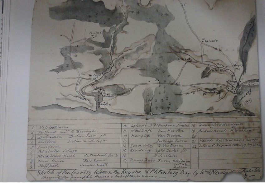
Contents

I. Introduction                                                             3
II. Description of the forest                                               3
     1. Forest types                                                        3
        1.1. Southern Cape Afrotemperate Forest (high and low forest)       4
        1.2. Western Cape Milkwood Forest (low forest)                      4
III. Historical distribution of southern Cape forests                       4
IV. Factors limiting forest occurrence and distribution                     4
     1. Environmental factors                                               4
     2. Human factors                                                       5
        2.1. Before the arrival of European settlers                        5
        2.2. Since the arrival of Europeans to the area during the 1700’s   5
           2.2.1. Forest exploitation and clearing                          5
           2.2.2. Grazing                                                   6
           2.2.3. Fire (man-made)                                           7
           2.2.4. Plantation forestry                                       7
V. Source of misperceptions about the distribution of forests               8
VI. The truth (reality) about the forests                                   9
     1. Historical proof                                                    9
        1.1. Early traveler descriptions                                    9
           1.1.1. Area around George                                        9
           1.1.2. Area around Plettenberg Bay                               10
           1.1.3. George, Knysna and Tsitsikamma areas                      10
           1.1.4. Tsitsikamma area                                          11
        1.2. Historical maps, sketches and paintings                        11
     2. Scientific proof                                                    12
        2.1. Fynbos islands                                                 12
        2.2. Forests                                                        12
           2.2.1 The work of John Frederick Vicars Phillips                 12
           2.2.2 The work of Coert J. Geldenhuys                            13
VII. Attempted establishment of forest in grassland (fynbos) areas          16
VIII. Current status and harvesting of the forests                          16
     1. Current status                                                      16
     2. Harvesting                                                          17
IX. The Implications of enduring popular beliefs and how to rectify them    17
X. Conclusion                                                               18
XI. Acknowledgements                                                        19
XII. Bibliography                                                           19

XIII. Appendices:
    A. Opinions from experts and local people                               21
    B. Map: Garden route vegetation                                         30
    C. Map: Distribution of the forests (1985)                              31
    D. Map: De Poort (1845)                                                 32
    E. Map: Harkerville drawing extract (circa 1910)                        33
    F. Map: Extract of Knysna Forest Lots (circa 1860) (a)                  34
    G. Map: Extract of Knysna Forest Lots (circa 1860) (b)                  35
    H. Map: Karatara (1874)                                                 36
    I. Map: Knysna (circa 1850)                                             37
    J. Painting: Knysna area (1778)                                         38
    K. Photo: Millwood (circa 1870)                                         40
    L. Map: Fisanthoek Forest (1885)                                        41

                                           Page 2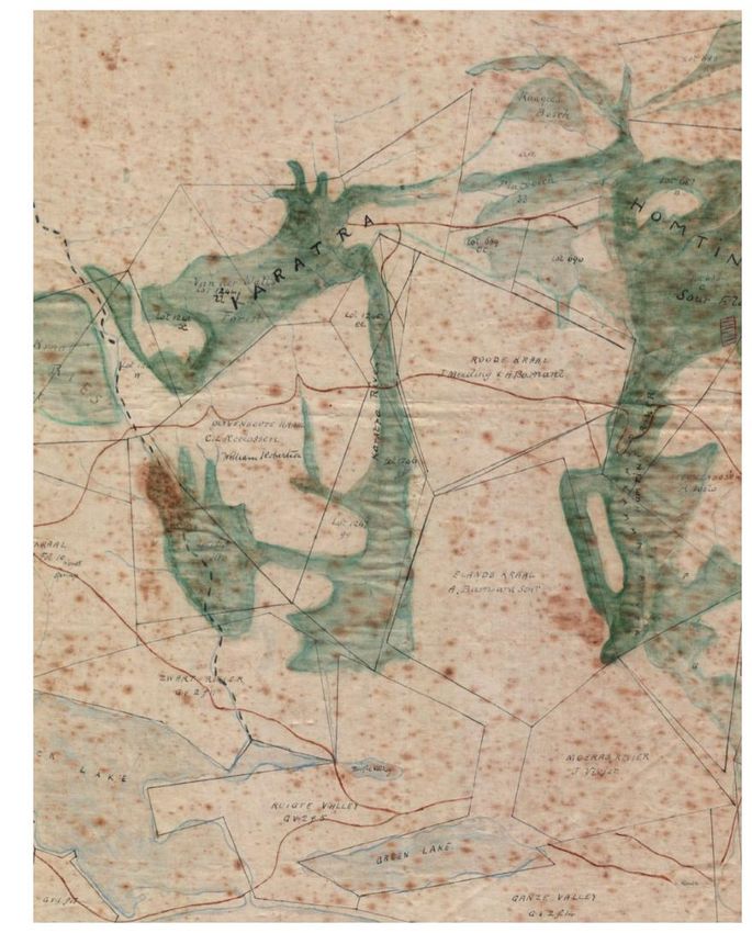
I. Introduction

According to studies, forests are found in areas that receive annual rainfall ranging between 525 mm
and 1220 mm. If you look at the George, Knysna and Tsitsikamma (southern Cape) forests, it can be
noted that there is no relationship between rainfall and the distribution of forests in the area. This
suggests, to some people, that humans changed the area through over-exploitation. It has been
suggested that much of the forested area from the Cape Peninsula to Port Elizabeth has been cleared
since 1652 (arrival of European settlers), and that destruction by humans is the reason for the
fragmented nature of the forests today. Many people also believe that if an area’s climate is ideal for
forest growth (>500 mm annual rainfall), the whole area (coastal plateau and sea-facing mountain
slopes) will be covered in forest, and that areas where human activities are currently taking place
(agriculture, plantations etc.) were covered with forests originally.
The purpose of this article is to prove that the above statements believed by most people are false,
and that the distribution of the southern Cape forests has not changed much since the arrival of
settlers.

Note: The information in this paper is only based on the southern Cape forests. The forests on the
east coast (KZN) were over-exploited drastically, and their distribution is not necessary the same
today as it was originally.

                              II. Description of the forest:

The Knysna forest is the largest forest complex in Southern Africa, and is found in the Southern
Cape and covers an area of about 60,500 ha. The forest includes high (>20 m) and scrub (3 m) forest,
and is found in fragmented patches on the seaward side of the coastal mountains (Geldenhuys,
1991). The largest forests can be found on the foothills of mountains, coastal platform, river valleys
and coastal scarp. The Goudveld-Diepwalle-Harkerville forest is the largest single, continuous forest
in southern Africa and covers all landscape zones except dunes (Geldenhuys, 1991). In contrast, the
largest number of forests is found in the mountains but only cover a small area. It’s the only forest in
southern Africa that has been used for timber almost continuously since its discovery by settlers in
the 1750’s (Geldenhuys, 1991). This ecoregion represents the southernmost patches of Afromontane
forest in Africa. The predominant geology is quartzite, shale, schist, conglomerate and dune sand.
The soils of these forests are generally acidic and nutrient-poor. Much of the Knysna forest occurs
on gentle to moderate slopes, ranging from 5 m to 1,220 m above sea level with a mean of 240 m.
Rain falls throughout the year in the region, with the most rain in early and late summer. Annual
rainfall ranges from 525 mm to 1220 mm (Knysnawoodworkers, 2001).

Today most of the forests in the area are in formally protected areas like national parks and nature
reserves, and tight control now ensures that only small amounts of timber are harvested for the
furniture industry. Some larger forests are in the hands of private owners, such as Geo Parkes &
Sons and PG Bison (formerly Thesen & Co.), who utilise the forests under very strict regulations.

1. Forest types:

Two national forest types occur in the Garden Route; the Southern Cape Afrotemperate Forest
and Western Cape Milkwood Forest.

                                               Page 3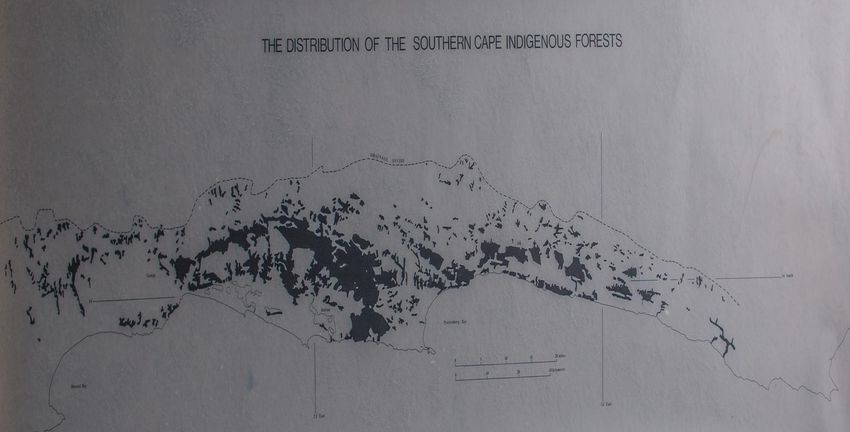
1.1. Southern Cape Afrotemperate Forest (high and low forest)
This forest type occurs from sea level to altitudes of 1000 m or more, and displays great variation
in forest structure, species composition and species density due to the variations in topography,
soils, microclimate and other factors. The forests occur in three distinct zones with distinct stand
structure and species composition:

- The mountain forests (mostly wet forests) are typical Afromontane forest.
- Dry forests or scrub forests occur on the coastal scarp or on the steep slopes of the river
  valleys. These forests are species-rich and include many species of Indian Ocean Coastal Belt
  forests.
- The plateau forests are typically moist and medium-moist forests and include mainly species of
   Afromontane affinity (GRNP: State of Knowledge, 2014).

1.2. Western Cape Milkwood Forest (low forest)

Western Cape Milkwood Forest occurs as small patches at altitudes between 20 m and 340 m
along the southern coast between Nature’s Valley and the Cape Peninsula. In the Garden Route,
patches occur inter alia at Nature’s Valley, Keurbooms, Knysna, Goukamma and Groenvlei
Forests in the Goukamma Nature Reserve, Sedgefield and Wilderness section of the Garden
Route National Park. The forests are generally low, species-poor and often dominated by only
one or a few canopy tree species with stunted or large stems and spreading crowns, usually
Sideroxylon inerme and/or Celtis africana and/or Apodytes dimidiata. The under storey may be
open, but is often a shrub layer with a diverse range of species (GRNP: State of Knowledge,
2014).

         III. Historical Distribution of the southern Cape forests

Palaeontological evidence suggests that forests, woodland, grassland and fynbos have occurred in
mosaics over the past 10 000 - 20 000 years (forests expanded during wetter periods, and shrank
during drier periods). Nevertheless, fynbos, grassland, woodland and savanna have been more
prominent the last couple of thousand years due to a drier climate as they are better adapted to arid
conditions and fire. “Fire plays a major role in determining the pattern of forest occurrence”
(Stehle, 2007).

During the past 400 years written evidence from accounts of Europeans describing the country,
portrays a situation not much different from the situation found today. This is further explained by
historical proof and scientific proof later in the article. This does not mean that there hasn’t been
forest destruction by humans. It is just that the scale at which this took place is much smaller than is
generally believed.

          IV. Factors limiting forest occurrence and distribution

1. Environmental factors
The potential of an area to sustain forest growth is determined by rainfall, temperature and geology,
but the actual occurrence and distribution patterns of forest in the area is determined by fire.
(See scientific proof for a more in-depth explanation)

                                               Page 4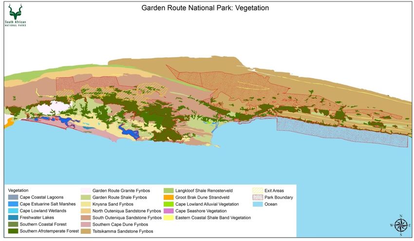
2. Human factors

2.1. Before the arrival of European settlers

The area was inhabited by Khoikhoi and San, who lived off the land for thousands of years before
the arrival of Europeans. The extinct San (Bushmen) were semi-nomadic hunter-gatherers. They
occasionally visited the forests, but did not dwell in or exploit the forests. Groups of San hunters
occasionally smoked animals out of the forests during hunts, and this could have been the cause of
some forest fires in the past (although fynbos was burned most of the time in order to drive animals
to where they could kill them as forests don’t burn easily). The Khoi people were pastoralists and
frequently burned the veld to obtain grazing for their cattle.
The Nguni people, who still utilise the under-storey of forests more to the east (Transkei), are not
known to have occupied the southern Cape forests.
They (Nguni) traditionally practised shifting cultivation as part of their culture for a very long time.
The impact of this shifting cultivation was small enough to allow for forests to recover. The Nguni
utilised and still utilise the under-storey of the forests for traditional purposes: Hut-poles, fence poles
and kraalwood. Although the degradation isn’t visible when looking at the forests superficially, the
future generation of trees in the under-storey, needed to fill gaps when the canopy trees die or are
removed, are slowly depleted and when the canopy trees eventually become senile and die, there is
no replacement for them, and this has serious consequences. This form of degradation is therefore
more damaging (Stehle, 2007).

2.2. Since the arrival of Europeans to the area during the 1700’s

2.2.1. Forest exploitation and clearing

The Dutch knew about the Overberg forests by 1688 and the “Outeniqualand” (George and Knysna)
forests by 1710. European settlement started in the middle 1700’s when pioneer colonists moved into
the “Outeniqualand” to farm, fish and cut timber. The Dutch East India Company (DEIC) extended
its control over the forests in the 1770’s and 1780’s by establishing woodcutter posts at George and
Plettenberg Bay (Joubert, 2021).
The settlers exploited timber from the forest because they needed bulky timber for building
purposes, carts and wagons, and later railway sleepers and mining struts. Portions of forest, bush and
shrubland were cleared for crops and grazing. “The clearing of forest would have been incidental
and probably ate into the margins, by excessive cutting (not clearing) and then fires from adjacent
fynbos may have burnt into some forests on the margins. But normally indigenous forest does not
burn easily. Especially not in the olden days when the climate was colder and moister. Dry hot
bergwinds in winter months did occur, and that could have here and there eaten slightly into the
forest. The bush and shrubland would have been largely fynbos, which grows very high in this area.
It is very difficult with manual labour to convert indigenous forest into farmland, and this is very
unlikely to have occurred because there were enough open fynbos areas to farm, mainly for grazing.
Cultivation was on a small scale more in the form of gardens to grow sweet potato maize and other
crops for subsistence use” (T. Stehle, personal comm., 5 April 2016).

The first attempts (policy) aimed to protect the forests were initiated in the 1780s, but the first
adequate (scientific) system of conservation had only been introduced by 1882. This led to the
single-tree selection system of Laughton (Joubert, 2021).

By 1874 the George forests west of Touw River were mostly worked out and damaged by fire
(Joubert, 2021). “...It is true that forests had been worked out, that is, depleted of timber trees,
especially the larger ones, but that did not mean they were destroyed. Such forests, if given a chance,
would have recovered over time. Maybe smaller portions of low scrub forest that had been worked
out, were subsequently damaged/destroyed by wildfires, but the latter, due to the damp and cool
climate of this area, occurred at a very low frequency. Only in recent years, say the last twenty to

                                                 Page 5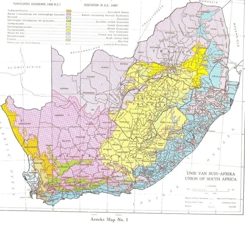
thirty years, due to climate change, did the frequency of wildfires in this area increase” (T. Stehle,
personal comm., 5 April 2016).

Exploitation damage in the forest in the eastern Tsitsikamma (from Blueliliesbush eastward) was
common before 1856, but even by 1872 the western Tsitsikamma between the Soutrivier and the
Storms River was relatively unoccupied (Joubert, 2021). Exploitation by the Europeans on the whole
did less permanent damage to the forests because they intervened mainly in the forest canopy, which
more closely resembles the natural dynamics. The reason is that the larger canopy forming trees, by
allowing sunlight to penetrate lower into the forest, enable sub-canopy opportunist recruits to fill the
gaps formed by their removal. As long as the forest soil is not destroyed, the forest will recover if
allowed (Stehle, 2007).

Sections of forests were sold from 1846 to 1856, and again from the 1860’s until the 1870’s. The
government sold portions of the forests (some were worked-out) as Forest Lots to private owners
who used the land for farming (“mealie gardens”) and/or woodcutting purposes (Joubert, 2021).
Some of the larger private forests in Knysna today were obtained during these sales (Geo Parkes &
Sons etc.).
Clearing of forest still continues today, but only on a small scale for strategic purposes, e.g. the
building of roads and dams, where there are no alternatives. A private company cleared about 140ha
of forest (part of the Diepwalle-Fisanthoek complex) between 1958 and 1966 for conversion to
plantations. Small portions of forest (218ha) were cleared for the building of roads, agriculture and
dams during 1970 to 1980 in the southern Cape (Geldenhuys, 1991).

The Knysna forests have persisted in a moderately to densely populated rural environment, and,
according to Scriba (1984), most of the George forests on the relatively dry coastal foreland had
been cleared of forest by humans in recent historical times. However, Prof. Geldenhuys does not
fully agree with Scriba’s statement, he states that the area of George was never covered in forest:
“I think that even places like George were not covered in forest - there are valleys covered in forest
which expand because of the wattle and pine…(exotic trees promote forest growth)” (C.
Geldenhuys, personal comm., 3 February 2016).

Important: Suggestions that all open areas adjacent to forest were forest previously, and were cleared
during recent historical times must be viewed with caution. “Clearing and conversion to agriculture
land of large areas of forest with modern equipment and methods is a formidable task today. During
the 18th and 19th centuries only relatively small areas of forest would have been cleared on the
margins of forests to enlarge existing openings. Clearing for agriculture was confined to the
foothills and coastal platforms and would not explain the intense fragmentation of the mountain
forests” (Geldenhuys, 1991).

Generally, direct human impact on natural forests has been rather to degrade than to wipe out forest.
However, forest degradation has made the forest more vulnerable to fire, as a secondary agent of
destruction.

2.2.2. Grazing

The pattern of forest and open country around Plettenberg Bay existed before the exploitation of the
forests began (Geldenhuys, 1991). A mosaic of grassland (fynbos), shrub, and forest, similar to the
present, is pictured in the writings of survivors of the wreck of the ship San Gonzales during June
1630 and early travellers (Geldenhuys, 1991).
Pastoralists with herds of sheep and cattle inhabited the area around Plettenberg Bay for a very long
time, and they used the open fields in the area of the Bay to graze their cattle and sheep.
Forest regulations issued in 1856 entitled each holder of a timber license to take 16 oxen to the
forests and to graze them for ten days adjacent government or other lands under servitude of grazing
(Geldenhuys, 1991; Joubert, 2021). “This was on tracts of fynbos occurring inside the boundaries of

                                               Page 6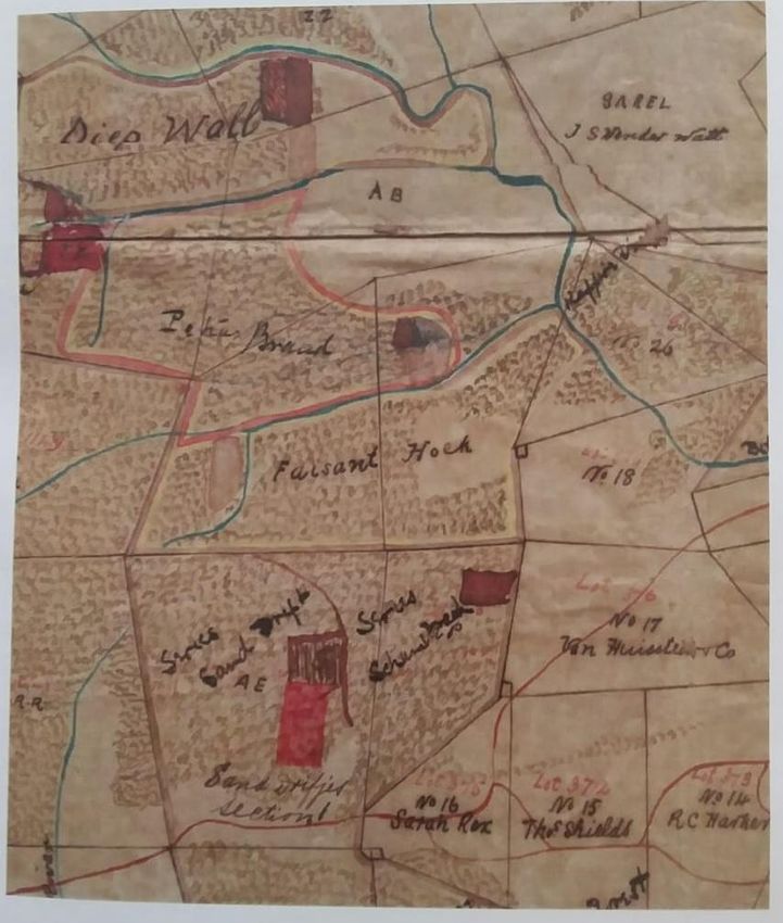
Crown Forests (i.e. Crown or State land), which was burnt periodically to obtain some palatable
grazing for trek oxen. These later became commonages associated with woodcutter allotments,
where the trek oxen could be depastured on communal land” (T.Stehle, personal comm., 5 April
2016).
Plenty of buffalo and elephant were still present by 1875, and both these animals occurred in herds
and favoured more open vegetation such as woodland, shrubland, and grassland. They used the
forests for shelter, and will also, at times, feed in the forest (Geldenhuys, 1991).
“This (elephants feeding in the forest) occurred only in much later years when the elephants were
forced into forest by human habitation on the open areas around the forest. The forest is extremely
unpalatable for herbivores, and only when forced to, they will browse forest tree leaves” (T. Stehle,
personal comm., 5 April 2016).

The area west of George was known amongst the farmers as “grassveld” (grassland), and was
favoured in earlier times for seasonal grazing (Geldenhuys, 1991).

2.2.3. Fire (man-made)

Fire has been used by man for about a million years and for some form of veld management in the
fynbos area for at least the last 100 000 years (long before pastoralism).

Some European farmers burned the forest margins in order to illegally extend farm land. Farmland
and fynbos was sometimes burned by farmers to get pasture used for grazing or to make the land
more fertile, accidentally eroding the forest margin (P. Caveney, personal comm., 23 February
2016).

2.2.4. Plantation forestry

The first exotic timber plantations were established in 1877 with the goal of augmenting the
timber from the indigenous forests, which could not meet the demand for timber any more
(Joubert, 2021). Most of the plantations were established on areas that were covered with fynbos
previously. A relatively small area of forest that had been seriously degraded during the
woodcutter period in the Knysna area, was planted with exotic plantations. However, in that area
there is, after many years, the tendency for indigenous forest to re-establish itself aggressively
(Geldenhuys, 1991). An example of this is Bracken Hill.

The Great Fire of 1869 burnt large parts (mostly forest margins) of the indigenous forest in the
Knysna and George districts. From that fire, “invader” trees like various species of pine and
Eucalyptus, as well as Blackwood were planted by the large property owners and sawmillers like
Thesen’s, Geo Parkes & Sons and PJ van Reenen. Some of the exotic trees were planted in areas that
had burnt down and were cleared by the fire, but most were planted on fynbos islands that existed in
these areas (G. Parkes, personal comm., 17 February 2016).

Some people think that plantations threaten the indigenous forests, but this is in fact not the case.
Plantations actually protect the forest in the following ways:
   - Provides protection from fire (only if the plantation does not catch fire and burn)
   - Is an alternative timber source
   - Forms a nurse stand for the expansion of forest (although only temporary as the plantation is
        situated in the fire-prone zone)
   -
Plantations therefore provide us with indirect evidence that forest is limited in the area because of
uncontrolled fires in the past (Geldenhuys, 1991).

                                              Page 7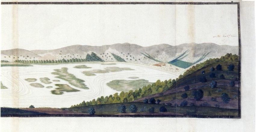
V. Source of misperceptions about the distribution of forests

High rainfall and forests have always been connected with one another. Scientists of about 150 years
ago believed that rainfall could be increased by forests. Today, we know that the occurrence and
development of forests is determined by several habitat factors such as climate (of which rainfall is
the main determinant), geology, fire and the sub-soil moisture regime.
Nevertheless, the potential for forests to exist has for a long time been (and still is being) determined
by rainfall, without taking other habitat factors that restrict the development of forests, into
consideration.
In recent years, the first complete vegetation classification for South Africa, attempted by J.P.H.
Acocks in 1953 (“Veld Types of South Africa”), has probably contributed to the perception that the
southern and eastern coastal belts were completely covered in forest in about AD 1400. His book
included a map with the title “Vegetation in AD 1400?” (see map below – forest in blue). Sadly only
a few people notice the question mark (at the end of the map title) and realise that both the book and
map are based on assumptions. This assumption was, in all likelihood, based on the rainfall potential
(Stehle, 2007).

This publication, revised in 1988, was, although based on agricultural potential, for decades the
standard classification for vegetation in the country and has only recently (since the 1980’s) been
replaced by more modern scientific classifications. The area on the above map coloured in blue,
is supposed to have been the extent of the indigenous forests before the advent of Europeans and
the Black peoples, which suggests that large scale destruction of forests has occurred since then
(Stehle, 2007).

                                                Page 8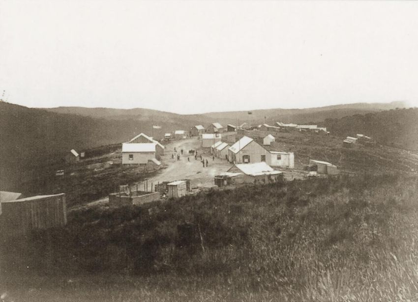
VI. The truth (reality) about the forests

The situation depicted by Acocks is false, and is realised by very few people today. Even some of
the top natural scientists have been misled.

The true facts are based on historical proof and scientific proof.

1. Historical proof
1.1. Early traveler descriptions

Even the most educated naturalists of the eighteenth and nineteenth centuries were not ecologists
and had a limited knowledge of vegetation as units. They were mostly systematic botanists who
collected plant specimens to preserve and name them. Some of them recorded their travels through
South Africa in vivid terms, but the descriptions of vegetation were very primitive and scant
(Stehle, 2007).

Nevertheless, two renowned Swedish scientists that travelled through the Cape in the late 1700’s
(about 100 years after Van Riebeeck established the first European settlement in Table Bay)
described the vegetation of the southern Cape coastal areas in such terms that it can be interpreted by
us today. They were Carl Peter Thunberg and Anders Sparrman. These two left descriptions behind
that show that the area consisted of a mosaic of forest and fynbos, much like the area today. The
descriptions by Sir John Barrow will also be used for the purpose of the research. He was an English
statesman and writer who travelled through the Cape during the late 1700’s and compiled various
notes and sketches of the countryside that he was traversing. A description by Captain Jones of the
Royal Navy will also be included.

People whose descriptions will be used:

    -   Carl Thunberg: Swedish naturalist
    -   Anders Sparrman: Swedish naturalist
    -   Sir John Barrow: English statesman and writer
    -   Captain Jones of the Royal Navy

1.1.1. Area around George

    -   Descriptions by Carl Thunberg:

An excerpt describing the countryside around George:

                                               1772

        “The country here, in general, consisted of extensive plains full of rich pasture, interspersed
with hillocks, and valleys, that abounded in wood and water” (Skead, 2009).

This is still the situation today. The rivers form forested valleys and between the rivers there are
wide ridges that form “plains” on which the grazing farms are situated today. That the pasture was
obtained by burning the generally inedible fynbos, is clear from the following description:

                                                1772

                                               Page 9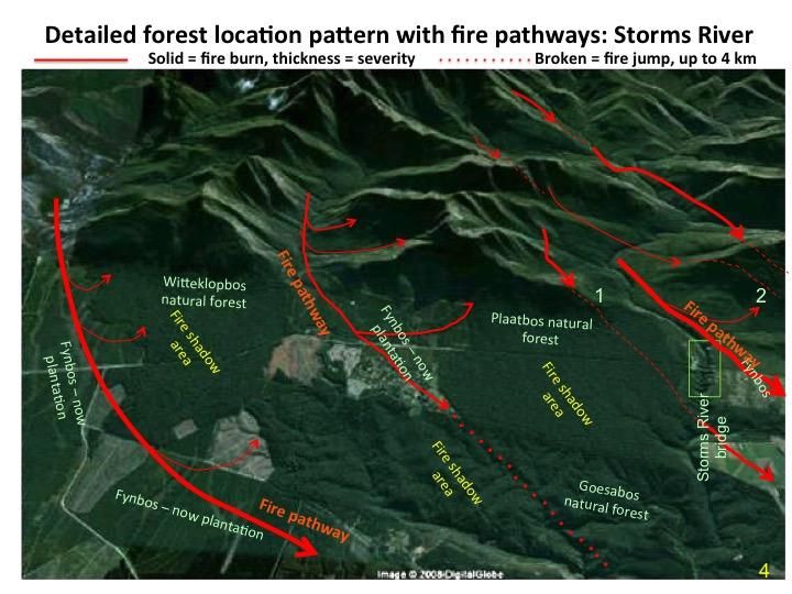
“Divers plains here, produce a very high sort of grass (anyone that is familiar with the
southern Cape fynbos, knows that it grows to a height of 2m or more when in its climax stage),
which being of too coarse a nature, and unfit food for cattle, is not consumed and thus prevents fresh
verdure from shooting up (again, this typically describes the grazing potential of mature fynbos)…
Such a piece of land as this, therefore, is set on fire, to the end that new grass may spring up from
the roots (this is what happens after a fynbos burn, sprouters, grasses and other pioneer vegetation
form the first successional stage, and these are edible for grazers for some time after a fire)” (Skead,
2009).

    -   Description by Anders Sparrman:

                                                 1775

       “Houtniquas land, which is a woody tract of country, is supposed to commence to the
eastward of the Groote Brakrivier (Great Brak River) and to extend to Keurebooms River
(Keurbooms River) which empties itself into Algoa Bay (Plettenberg Bay). Along the side of these
mountains runs a wood…On the western side of Keerom-rivier (Kaaimans River) or the hither side
of the Houtniquas, between the wood just spoken of and the seashore, there are extensive plains of
indifferent grass. There was likewise in the vales near the shore some woody tracts of land and
streams of fresh water” (Skead, 2009).

1.1.2. Area around Plettenberg Bay

    -   Description by Carl Thunberg:

In the area around Plettenberg Bay, the following description of habitat for buffaloes similarly
indicates a mosaic of forest and fynbos:

                                                 1772

       “The fields hereabouts were full of wild buffaloes, so that it was not uncommon to see a
hundred or two of them in a herd (which wouldn’t have been possible if all was forest). They
generally lie still in the thickets and woods in the day time, and in the night go out into the fields to
graze” (Skead, 2009).

    -   Description by Sir John Barrow:

                                                 1799

        “The District of Plettenberg Bay is in fact a rich field for the naturalist... The greatest
part of the forest trees still remain unexamined... The Plain of Hartebeests abounds
with that noble species of the antelope tribe from which it takes its name ...” (Skead, 2009).

1.1.3. George, Knysna and Tsitsikamma areas

    -   Description by Sir John Barrow:

                                                 1799

        “The extent of the forests, beginning at Mossel Bay and running eastward parallel to the sea
coast is at least 250 English miles and the breadth from the feet of the mountains to the sea is ten,

                                                Page
                                                10
fifteen, and in some places twenty miles. A great part of this tract is composed of large and beautiful
plains intersected by numerous rivers, and abounding in lakes full of excellent fish...” (Skead, 2009).
- Description by Captain Jones of the Royal Navy
1812
“These forests are by no means so extensive as has been reported… They commence at some
distance on this side of the Gouritz River, and extend eastwards to the Erate, or first river, situated
directly under Pic Formosa, or the Grenadier’s Cap, about 120 miles in a right line, and are
confined between a chain of mountains parallel to the sea, and distant from it in a mean, between 8
and 9 miles. Between the Gouritz and Knysna Rivers they are generally no more than a belt at the
foot of the mountains, from half a mile to a mile in breadth, and very large tracts of naked land often
interpose. In some parts there are patches between the mountains and the sea, and along every river
they continue for a small breadth on either side to the sea, which, as the timber approaches it,
becomes less. They are very inconsiderable, either in extent or size of the timber, till near the
Kaayman’s River in Outeniqua land, between which and the Knysna River in Plettenberg Bay
district nature has placed insurmountable barriers to the removal of heavy timber” (Brown, 1887).
1.1.4. Tsitsikamma area
- Description by Sir John Barrow:
1799
“It is chiefly covered with impenetrable forest, on the east of which however, there are
extensive plains equally good for the cultivation of grain and the grazing of cattle” (Skead, 2009).
1.2. Historical maps, sketches and paintings
Early travelers, residents and the government drew maps, sketches and paintings of the surrounding
area’s landscape. By comparing historical maps and paintings with modern maps and photos, it can
be noticed that the distribution of forests in the area did not change very much from the late 1700’s
onwards.
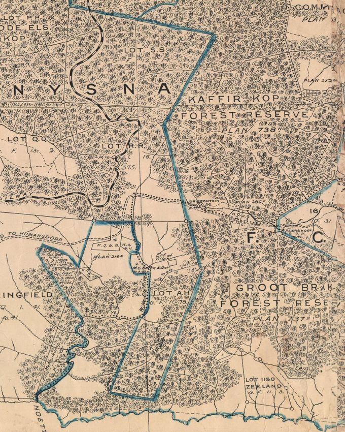
Some of the old maps and paintings are included in the appendices found later in the article. The
following can be seen by looking at these artifacts:
- Area around the Garden of Eden:
Appendices D, E and L show that the strip of forest around the Garden of Eden and De
Poort was always very narrow.
- Knysna estuary and town:
Appendices F and J prove that the area around the Knysna estuary and town was not covered
in forests.
- The distribution of forests in Karatara and the Plettenberg Bay-Knysna districts:
Appendices H and I prove that the distribution of forests in Karatara, Knysna and
Plettenberg Bay did not change very much since the 1850’s/1870’s onwards.
- Millwood:
Page
11Appendix K indicates that the surrounding hills around the town of Millwood were mostly
covered in fynbos, and not forests (as believed by most people).
2. Scientific proof
Scientific studies done in the southern Cape over recent years by various scientists provide evidence
about the occurrence and distribution of indigenous forests (past and present). There were also
studies done on the occurrence of fynbos patches frequently found in between forests called ‘fynbos
islands’.
2.1. Studies done on fynbos islands
An interesting feature of forest in the Garden Route, is the presence of fynbos islands (i.e. fynbos
completely surrounded by forest). The earlier belief was that these islands were man-made and
created by the clearing of forest. Geldenhuys (1991) believes that these islands were formed by fire
caused by lightning. Phillips (1931) conducted that these islands originated by the use of fire by
forest-dwelling parties of the now extinct San hunters. However, Inskeep (1987) regarded the islands
as an ancient and natural feature, kept open in part by the grazing of buffalo (Geldenhuys, 1991).
Here is an abstract from an article conducted by Theo Stehle on the presence of fynbos islands
within the Garden Route forests:
“A scientific article by Bond and Midgley (1990) about studies done on the origins of the
Knysna fynbos islands, reveals that, contrary to popular belief, the islands of fynbos inside the sea of
natural forest are not the result of anthropogenic disturbances of forest, but are remnants of a once
(very long ago) continuous expanse of fynbos, now isolated by expanding forest. Whereas some
forest species are able, in the absence of fire, to colonise fynbos, fynbos species are not capable of
invading forest. They concluded that fire was the major factor determining the forest/fynbos
boundary” (Stehle, 2007).
2.2. Studies done on the southern Cape forests regarding it’s original extent, and the interaction
between the fires in the landscape and the location pattern of the forests and Fynbos
2.2.1) The work of John Frederick Vicars Phillips
J. F. V. Phillips was a South African forester, ecologist, conservationist and agriculturalist who
went to Scotland to train in forestry and botany at Edinburg University (1919-1922). There he
later obtained a DSc (1927) for his thesis entitled Forest succession and ecology in the Knysna
region, later published as volume 14 of Memoirs of the Botanical Survey of South Africa (1931).
One of Phillips’ studies was based on the opinion of A. F. W. Schimper (a German botanist and
phytogeographer who visited the southern Cape area on collecting trips in 1898) found in an
article published in 1908.
Schimper was of the opinion that it was unlikely that the whole area was covered in forests
previously, but no reasons were ever given for his opinion. He considered that areas of primitive
fynbos existed near the forests, and that these were increased by man at the expense of the
adjacent forests.
Phillips did careful and extensive research since 1922 with fynbos-clad soil situated near and far
from the forests in the area of Knysna. Numerous examinations of soil strata and of vegetation
Page
12relicts were carried out, which culminated in his DSc. The results from these studies are
summarized below:
a) Areas of fynbos exist that show no signs of forest relicts in their soil strata. Such areas
bear a shorter, less luxuriant type of fynbos (even where protected from fire, grazing and
other disturbances) than the areas described below. This fynbos type is the most common,
and has never been forest previously. This type occurs in upper mountain slopes, the whole
of the summits of the range, portions of the foothills and certain lateritic portions of the
plateau (Phillips, 1927).
b) Extensive areas of fynbos exist where large numbers of forest relicts have been taken
from the soil (in the form of ancient, and often charred, roots and stems, and charred
resinous matter). Microscopic examination of these relicts has shown them to be composed
of forest species found in the forests today. In addition to wood and resinous matter there
were well-defined, incinerated layers in the soil, at depths of 12 to 18 inches; too deep to be
the results of fire in the fynbos. The fynbos, wherever protected, grows tall, and shows the
presence of scrub, bush and forest forms. The manner in which the areas of this fynbos type
connect innumerable forest patches certainly supports the hypothesis that the forests covered
them previously. Judging from the appearance of most of the relicts and from the depth of
these below the surface, the forests to which they relate, must have disappeared from the
ground centuries before the arrival of Europeans. But, it must be noted that some relicts
belonged to forests that occupied the soil less than a century ago (Phillips, 1927).
c) Actual relict trees or small relict communities occur at distances of several miles from the
forests, in places where they receive protection from fire and other agencies of disturbance.
The soil strata of the areas of fynbos linking up such relict patches, invariably show the
presence of wood relicts (Phillips, 1927).
Phillips (1927) states: “Were it possible to preserve strictly the Macchia (and the scattered scrub
and bush relicts mingled with the latter) occurring on areas akin to types (b) and (c) described
above, steady re-afforestation would take place by process of succession.”
The above-mentioned point made by Phillips in 1927 was in fact correct, as most ‘cleared’ forest
margins have developed back to indigenous forest, naturally, during the 1960’s, 1970’s and
1980’s.
2.2.2) The work of Coert J Geldenhuys
The most convincing work has been that of Coert Geldenhuys, who did his Ph.D. on the
environmental and biogeographic influences on the distribution and composition of the southern
Cape forests (1989). He has been actively involved in southern Cape forest research since 1969.
Fire determines the forest location patterns in the landscape, throughout South Africa and in the
rest of Africa, including the tropics (C. Geldenhuys, personal comm., 2 February 2016). The
forest patterns depend on how long a person goes back in the past, but the departure point, for the
purpose of this article, is the arrival of the settlers. The study of the fire patterns was done in the
Tsitsikamma part of the Southern Cape. When the settlers arrived in the Tsitsikamma, there was
already some form of control on the harvesting of indigenous forest (Geldenhuys, 1994).
Most people’s perception seems to be that the settlers cut down and cleared the forests in order to
practice agriculture. There were probably few such places, but by far in the minority (C.
Geldenhuys, personal comm., 2 February 2016). People had a lot of trees cut down, but the
descriptions left behind by early settlers does not talk about the clearing of the forests, but rather
Page
13over-exploitation of the forests. The patterns of the forests in the landscape are completely
according to a specific natural and explicable pattern without straight boundary lines, as would
have been made by people (C. Geldenhuys, personal comm., 2 February 2016).
The potential of forest presence in an area is determined by rainfall, and to a lesser extent,
temperature and geology. Geology does not limit forest growth when there is enough rainfall in
an area, but it determines the form of the landscape, which in turn determines the fire patterns
(Geldenhuys, 1994). The study proved that, if an area has the potential for forests to grow, it
does not mean that the whole area will be covered in forests, and where forest is actually found
in the landscape is determined by the fire patterns (Geldenhuys, 1994). Protection provided by
certain topographic features (river valleys, below slope breaks, etc) shelter the forest from fire.
These sheltered areas where forests are found and protected from fire are called fire shadow
areas (Geldenhuys, 1994).
It had been stated that the average rainfall limit for forest to occur in the summer rainfall regions
is about 750mm and in the all-year/winter rainfall regions is about 500 mm. A higher rainfall
does not necessarily mean that forest can expand unlimitedly, and persist (C. Geldenhuys,
personal comm., 6 February 2016). If one takes the average annual rainfall limit of 800 mm rain /
year, then the area where forest could potentially grow covers about 7% of South Africa - but the
reality is that forest cover 0.1% of the land area in South Africa. The difference of 6.9% is
primarily due to fire. People must keep this in mind when looking at areas in the southern Cape
where agriculture is taking place; the area has the potential to have forest, but it is absent
primarily due to the role of factors such as fire as mentioned above (Geldenhuys, 1994).
Before the settlers arrived in George around 1750, the forests were much smaller than today, but
with clear boundaries between forest and fynbos, and where the effects of landscape physiography
on forest presence effects could be seen more clearly, such as currently seen in the southern Cape
mountains (C. Geldenhuys, personal comm., 2 February 2016). Forest is surrounded by fynbos, a fire
driven ecosystem that requires fire to maintain itself. These fires also maintain the forest-fynbos
boundary (W. Vermeulen, personal comm., 15 Feb 2016). The absence of fire results in forest
expansion, while the opposite occurs during intense fires (W. Vermeulen, personal comm., 15 Feb
2016). The areas where people practice agriculture, and where the plantations of forestry are
established, lies completely within the fire zone, and with natural fire distribution patterns disrupted
(e.g. fire protection measures for timber plantations, intensive agriculture or a greater degree of fire
management), it will contribute to the establishment of more trees, mostly invasive alien plants (C.
Geldenhuys, personal comm., 2 February 2016; W. Vermeulen, personal comm., 15 Feb 2016).
Many introduced tree species do not grow in shade and establishes in open fynbos areas or grassland
adjacent to indigenous forests, and, on the other hand, indigenous forest trees prefer shade under the
forest canopy to germinate and grow (C. Geldenhuys, personal comm., 2 February 2016). The alien
trees therefore act as a nurse stand for the indigenous trees to grow because of the shade. This is why
there are forest species now in areas which were previously covered with grassland and fynbos. This
leaves the impression that forest has occurred in many places which is not necessarily true (C.
Geldenhuys, personal comm., 2 February 2016).
Fire patterns thus have a major impact on the distribution of forests and the shape of forest patches
and their boundaries. The facts stated above mean that fire, indirectly favoured by climate (rainfall),
has played a dominant role in determining the mosaic of fynbos and forest that developed over very
long times.
Page
14(With acknowledgement of Prof. Coert Geldenhuys)
(With acknowledgement of Prof. Coert Geldenhuys)
Page
15VII. Attempted establishment of forest in grassland (fynbos) areas
Any attempts to try and establish natural forest in grassland or fynbos areas close to patches of
natural forest, have been abortive. Even if the introduced tree plants grow, they never develop
properly and only survive till the next fire wipes them out (Stehle, 2007).
Small-scale reconstruction or establishment of natural forest in the southern Cape has been
successful only where the local habitat conditions favour the development of natural forest. In cases
where fynbos had been the natural vegetation before, the establishment of indigenous forest over
larger areas had been unsuccessful. In cases where natural invasion of indigenous forest precursor
species into adjacent fynbos took place because of an abnormal absence of fire, it did not develop
into forest, either because of the absence of the optimal habitat conditions, or the forest margin
having been set back to its original position by fire (Stehle, 2007).
VIII. Current status and harvesting of the forests
1. Current status
Both publicly owned and privately owned forests are now in an advanced state of recovery from
past timber exploitation (large parts of the forests are of secondary nature, meaning it has re-
grown after heavy exploitation. There is no evidence to suggest that some species are more or
less common. The only significant change would be a change in size-class distribution of trees,
with less old-growth. There is a section in the Gouna forest which has not (apparently) been
exploited at all). Many of these forests are run by a policy to rehabilitate destroyed forests,
consolidate existing forest patches by reconverting abandoned plantations or forest margins to
manageable boundaries, and to eliminate alien vegetation.
Sustainable timber harvesting is currently practiced according to a timber yield regulation system
(SA Forestry online, 2010). Yield regulation is the science of determining inter alia what species
and products you may harvest, where, when, and how much. Nature conservation remains the
primary aim of management in the Garden Route forest areas, so a timber yield regulation
system was developed that has minimum ecological impacts and mimics the natural turnover and
disturbance mechanisms at work in the forests as closely as possible so as to ensure an optimal
sustainable yield. The result was a single tree selection system based on natural mortality
patterns.
Timber harvesting may only take place in areas where it is compatible with other long-term
management objectives. It is only carried out in accessible medium-moist and moist high forest
types where harvesting is feasible. The other forest types are either ecologically too sensitive or
do not have sufficient trees of marketable size. Approximately 9 200 ha of forest is zoned for
sustainable timber utilisation. However, timber is not harvested in the ecologically sensitive parts
of these areas, including areas that are too steep or too wet, so the area actually harvested is less
than this, approximately 6 500 ha (SA Forestry online, 2010).
The indigenous forests, with their mixture of trees of various sizes, ages and species, are
managed for timber production on a different system to exotic plantations (SA Forestry online,
2010). There is no clearfelling, but rather a selected removal of trees on a ten-year cutting cycle,
ie. a number of trees are harvested from a particular area only once every 10 years. Each timber
production compartment is scheduled for harvesting in a particular year so that approximately
Page
16one tenth of the total effective area is harvested annually (600-650 ha/a). These timber
production compartments are scattered throughout the area (SA Forestry online, 2010).
A crucial component of any timber yield regulation system is the method used to select trees for
harvest. The system used in the Garden Route forests is a single tree selection system that was
developed locally, known as the Senility Criteria Harvesting (SCH) yield regulation system.
Harvest tree selection criteria have been compiled for each of the main canopy species. Visible
signs of senility and decline, such as crown dieback, structural damage and stem decay, are used
to identify trees for harvesting that are senile and have a short remaining life expectancy, ie. trees
that are busy dying. A tree complying with one of the criteria for that species is identified as a
candidate for harvesting. Severity of crown dieback is generally the best indicator of senility, but
other parameters such as structural damage, degree of stem decay and incidence of epicormic
shoots also tend to be related to senility, depending on the species. Trees displaying advanced
signs of senility often have a low growth rate (SA Forestry online, 2010).
The harvest tree selection criteria were compiled after an intensive survey in a long-term
research area at Diepwalle Forest, for which reliable increment, ingrowth and mortality data
exists (SA Forestry online, 2010). Over 2 400 canopy trees of the main canopy species were
evaluated for possible visible signs of senility, low vigour or reduced life expectancy. Species-
specific harvest selection criteria were then compiled that provided harvests equivalent to the
natural rate of mortality. The application of these criteria on a 10-year cycle should thus produce
a harvest that is equivalent to the natural mortality over a period of 10 years for each species in
that area. All of the monitored trees have been re-evaluated three times over a period of 15 years
and the criteria refined to predict mortality more accurately (SA Forestry online, 2010).
Overall, the outlook for future protection and conservation of these forests is encouraging:
- South African National Parks (SANParks) and provincial authorities actively manage
over 70 percent of the total indigenous forested area
- Nearly 20 percent is conserved in proclaimed nature reserves and parks managed
privately
2. Harvesting
The forest is very sensitive to disturbance, in particular, soil compaction and drainage disturbance
(SA Forestry online, 2010). Reduced-impact logging techniques were introduced into the southern
Cape forests in the 1960s and have been applied consistently since the early 1980s, with a
continuous development and improvement in techniques and equipment. Large crowns are removed
before trees are felled, a procedure known as topping. Trees are felled carefully to reduce damage to
surrounding trees. Logs are not cut to maximum length, but rather to facilitate handling and reduce
damage within the forest (SA Forestry online, 2010).
The extraction of the logs from the forest is only carried out when the soils are sufficiently dry, as
wet soil is much more prone to disturbance and compaction. Heavy machines are only allowed to
operate on permanent slipping paths, on which there is little further destruction to the organic soil
layer possible. Inside the forest, slipping is done with heavy draught horses or by cable and winch
from a machine on the slipping path (SA Forestry online, 2010).
IX. The Implications of enduring popular beliefs and how to rectify
them
Page
17Popular beliefs are difficult to get rid of, especially if scientists attach themselves to them (through
ignorance or established thinking patterns).
Nevertheless, unscientific opinions can often lead to misguided actions, which can lead to financial
repercussions and wasted efforts. People have been encouraged over the years to plant more
indigenous trees in order to re establish the ‘destroyed’ forests of the area.
The following was written by Stehle (2007) about the planting of indigenous trees:
“It has become fashionable to plant indigenous trees. This has been promoted over a number
of years for very good reasons, and is in itself commendable. However, the number of well meaning
people wanting to “re-establish” indigenous forest where it never occurred, and at the expense of
other natural vegetation types, is on the increase. It has even happened recently that a grandiose
scheme under the slogan “Bringing back the Forest to the Garden Route” was promoted to form
part of an IDP of a municipality, with the idea of job creation, restoration of destroyed forests and
the earning of carbon credits to offset air pollution causing global warming.
It is expensive to propagate tree plants in nurseries, to transport and plant them out in the field, and
then to lose them a few years later in a wildfire, just because they were planted where they could not
survive.
The other aspect to bear in mind is that to plant indigenous trees on any scale doesn’t mean that you
create an indigenous forest. An indigenous forest is much more than a stand of indigenous trees. It is
a complex ecosystem comprising the forest soil with all its biological components, including
microbes, and the forest macro and micro fauna and flora associated with the tree species. Anyone
endeavouring to establish “forest” will in all likelihood be disappointed if after a lot of expense and
effort, years later finds him or herself with a motley grove of dwarfed trees and shrubs, because of
exposure to harsh climatic elements, and lacking the soil characteristics and underground moisture
necessary for their development into forest. The required set of habitat conditions simply is not in
place. Worse still, if it succumbs to fire some or other time.
[The]...planting of indigenous trees where they do not naturally grow, is an interference with natural
patterns and processes similar to that of any artificial (simplified) ecosystem, like plantation forests,
horticulture or agriculture. If people are interested in restoring or rehabilitating natural ecosystems,
they should realise that our natural environment doesn’t comprise forests only, but other biomes are
equally important. Efforts should be directed at rehabilitating whatever natural ecosystem has
existed before. Anything else is artificial” (Stehle, 2007).
It is possible to change misperceptions. The first place to start is with the scientific community and
the conservation NGO’s. The correct information needs to be distributed in publications. False
information needs to be confronted with the correct information at every opportunity.
“Education of the population starts with the younger generation. Educational materials can be
distributed to schools and tertiary education institutions. Awareness raising needs to be done in all
levels of society. Greening campaigns, Arbor Week, etc. are all vehicles of conveying the right
information. The Forestry Branch of the Department of Water Affairs and Forestry has an
obligation and a responsibility in this regard, as the lead agent in the country regarding forests and
trees” (Stehle, 2007).
X. Conclusion
By reading historical descriptions left behind by early travellers, studying maps from the 1800’s and
focussing on the scientific work done by scientists, I came to the conclusion that the distribution of
Page
18forests did not change much since the arrival of man to the area. Some areas of forest were worked-
out (devoid of valuable wood) because of exploitation, but most areas have almost fully re-grown as
secondary forest today. People must understand that the potential for forest growth is determined by
rainfall, but fire determines the occurrence of forest in a landscape. Southern Cape Forests occur in
areas which are protected from the bergwind fires. Most of the farms and plantations we see today
are situated on areas which were covered with grassland or fynbos previously. Small areas at forest
margins would have been damaged in the past by illegal burning by farmers or by clearing in order
to enlarge existing openings. Only tiny areas have been worked out to such an extent that one can
say they were cleared, but some or probably most of them on the forest fringes (margins) have been
rehabilitated back to indigenous forest, and as the forest complex is so large, it did not make a very
big impact. The major difference in the forest of today compared with the forest of about 400 years
ago, would be the size difference of the trees. Most of the big (older) trees were cut down in recent
historical times, and it takes a few hundred years for some trees to reach maturity. Most of the forest
today is of secondary nature, and is in the process of becoming fully grown again (since the forest
has been closed from uncontrolled exploitation since 1939).
It is great news for us as South-Africans to know that these, near pristine, forests are still available
for all to see and appreciate. The greed of man almost destroyed this beautiful, complicated and
mysterious ecosystem. We must all take part in the protection of these forests to ensure that they will
still be here to see for many future generations...
XI. Acknowledgements
I would like to thank the following people who gave their input/ advice with my research:
- Dave Reynell (Retired forest scientist at DAFF Scientific services)
- Dr.Tineke Kraaij (Vegetation Ecologist at NMMU)
- Dr. Wessel Vermeulen (Retired Science Operations Manager at SANParks)
- George Parkes (Former Director at Geo Parkes & Sons)
- Graham Durrheim (Scientist: Forest Ecology at SANParks)
- Izak van der Merwe (Forest scientist at DAFF Scientific services)
- Jolanda Julyan (Lived in Knysna for 20 years, and her father was a forester in the area
for 47 years)
- Martin Lucas (Factory and Operations manager at Kluyts & Co, and former DAFF
forester)
- Philip Caveney (Chairman of the Knysna Historical Society)
- Prof Coert Geldenhuys (Forest Ecologist at University of Pretoria)
- Prof Josua Louw (Director of Natural Resource Management at NMMU)
- Riaan Stander (Works at Z.D. Stander & Seuns Vervoer & Ontginning)
- Theo Stehle (Retired DAFF professional forest officer)
- William Cooper (Retired DAFF forester)
XII. Bibliography
Brown J. C. (1887). Management of Crown Forests at the Cape of Good Hope under the old
regime and under the new. London: Simpkin, Marshall & CO
Page
19Department of Environmental Affairs and Tourism. 2010. The Garden Route Environmental
Management Framework. Department of Environmental Affairs unpublished report.
Discover Sedgefield South Africa. (2012). The Knysna forest Woodcutters. Available at:
http://www.discover-sedgefield-south-africa.com/Knysna-forest-woodcutters.html [Accessed 18
January 2016]
Geldenhuys, C.J. (1991). Distribution, size and ownership of forests in the southern Cape. South
African Journal of Forestry 158: 51-66.
Geldenhuys, C.J. (1994). Bergwind fires and the location pattern of forest patches in the
southern Cape landscape, South Africa. Journal of Biogeography (1994) 21, pp. 49-62.
Joubert, R. (2021) History of the Overberg, George, Knysna & Tsitsikamma forests: pre-modern
history to 2011. Available at: https://www.sahistory.org.za/archive/history-overberg-george-
knysna-tsitsikamma-forests-pre-modern-history-2011-ryno-joubert
Knysnawoodworkers. (2001). Conservation. Available at:
http://knysnawoodworkers.co.za/articles/conservation/ [Accessed 12 March 2016]
Nimmo, A. (1976). The Knysna Story. Cape Town: Juta
Phillips, J. F. V. (1927). Forest succession and ecology in the Knysna region. Memoirs of the
Botanical Survey of South Africa, volume 14 (1931).
Rustic homes. (2014). History of Forestry in SA. Available at:
http://www.rustichomes.co.za/blog/south-africas-managed-forests/ [Accessed 12 February 2016]
SA Forestry online. (October 2010). Natural Forests. Available at:
http://www.saforestryonline.co.za/articles/natural_forests/timber_yield_regulation_in_the_indige
nous_forests_of_the_garden_route/ [Accessed 3 April 2017]
SANParks. (n.d.). Garden Route (Tsitsikamma, Knysna, Wilderness) National Park.
Available at: https://www.sanparks.org/parks/garden_route/tourism/knysna_history.php
[Accessed 18 February 2016]
Seydack & Vermeulen (2004). Indigenous Forests and Woodlands in South Africa: Policy,
People and Practice. Scottsville: University of KwaZulu-Natal Press
Skead, C.J. (compiler) 2009. Historical plant incidence in southern Africa. Strelitzia 24. South
African National Biodiversity Institute, Pretoria.
Stehle, T.C. (2007). The occurrence of indigenous forests in South Africa: Historical and
current.
Storrar, P. (2001). Plettenberg Bay and the Paradise Coast. Craighall: TJM Publishers
South African National Parks. 2014. Garden Route National Park: State of Knowledge.
South African National Parks unpublished report.
Page
20XIII. Appendices
A
Opinions from experts and local people who know the area well
1. The Distribution and history of the forests
Izak van der Merwe:
“In 1999 I was contracted by the then Department of Water Affairs and Forestry to develop a book
titled The Knysna and Tsitsikamma Forests: Their History, Ecology and Management. At that time I
also had a perception that at least some parts of the forest areas were decimated by woodcutters or
claimed for land uses such as agriculture and forestry. This perception changed rapidly as I visited
the archives of the George and Knysna museums, and the national archives in Pretoria and Cape
Town. I read through many historic accounts, and gained valuable insights from historic maps and
photographs. The openness of the landscape of Knysna and its surroundings as portrayed in a
panoramic painting by Johannes Schumacher done in 1778 (Appendix J) fascinated me, I could
clearly see that there were forest patches embedded in a matrix of open hills. Like many others I
always thought, for example, that the Millwood village developed in the natural forest, but from the
photographs of the developing village (Appendix K) I could clearly see the surrounding hills
covered in fynbos. Almost all the photographs of the woodcutters I saw, show them working the
timber in a closed canopy forest environment, with very localised damage.
During that time I spent more than six months in the Knysna and Tsitsikamma forests, traversing
most of the footpaths, and beyond. What impressed me was that apart from the old woodcutter slip
paths still in use for the low level timber harvesting based on scientific criteria, I could find no sign
of the destruction that was reported by historic visitors such as Governor van Plettenberg. He
reported that there was much wastage and destruction by woodcutters, and while the layman might
tend to interpret this as destruction that was common throughout much of the forests, I soon realised
that this was not the case. The reason for the limited scale of destruction and why the forests
recovered so well, soon became apparent to me. The woodcutters did not do clear felling of trees.
They only targeted single trees of a select number of tree species, such as common yellowwood,
white pear and stinkwood, the timber of which was in demand by various industries. Building an ox
wagon would require various wood types for specific purposes, such as assegai for the spokes,
yellowwood for the wagon floor etc.
The single tree selection done by woodcutters meant that only small gaps were created in the forests,
and the recovery of these gaps were relatively fast due to young trees left standing, which competed
to close the gaps. Forest gap dynamics therefore played a major role, which is a faster recovery
process than the species succession required from the pioneer stage in clear-felled areas. Some
sawpits are still visible today, and where you find them there is absolutely no way in telling timber
was once felled there. Large forest trees stand all around these sawpits, under a high, closed
canopy. I even searched for signs of the 35 km railway route that once linked Knysna with Diepwalle
(after removal of the tracks), but in less than a century the forest has completely reclaimed this
Page
21You can also read