The Effects of Freight Vibrations on Slope Stability along the SH35, Bay of Plenty East, New Zealand
←
→
Page content transcription
If your browser does not render page correctly, please read the page content below
Journal of Geoscience and Environment Protection, 2020, 8, 335-345
                                                                                                   https://www.scirp.org/journal/gep
                                                                                                             ISSN Online: 2327-4344
                                                                                                               ISSN Print: 2327-4336

The Effects of Freight Vibrations on Slope
Stability along the SH35, Bay of Plenty East,
New Zealand

Angelo Indelicato

Stantec UK, Reading, UK

How to cite this paper: Indelicato, A.            Abstract
(2020). The Effects of Freight Vibrations on
Slope Stability along the SH35, Bay of Plenty     State Highway 35 (SH35) connects Opotiki to Gisborne along the Raukumara
East, New Zealand. Journal of Geoscience          Peninsula in the North Island, New Zealand. This corridor passes through an
and Environment Protection, 8, 335-345.
                                                  area which is prone to landslides, especially during the wet season. This, in
https://doi.org/10.4236/gep.2020.85021
                                                  turn, influences the traffic and has detrimental effects to the local economy,
Received: May 1, 2020                             as it is dependent mainly on tourism and commercial transportation by road.
Accepted: May 26, 2020                            This paper will focus on the landslides which occurred between June and
Published: May 29, 2020
                                                  September 2018, within the Bay of Plenty East on the north side of the Rau-
Copyright © 2020 by author(s) and                 kumara Peninsula. The paper will analyze both the nature and triggering
Scientific Research Publishing Inc.               mechanisms behind these landslides. As the landslides occur in the wet sea-
This work is licensed under the Creative          son, rainfall has been commonly considered the main trigger. However, the
Commons Attribution International
                                                  paper will argue that vehicle vibrations have been contributing to the instabil-
License (CC BY 4.0).
http://creativecommons.org/licenses/by/4.0/       ity of the slopes within the Bay of Plenty East. This paper will be instrumental
                Open Access                       in developing future transportation strategies in this part of the North Island.

                                                  Keywords
                                                  Landslide Trigger Mechanisms, Freight Vibration, Bay of Plenty East,
                                                  Raukumara Peninsula, New Zealand

                                                1. Introduction
                                                SH35 is the only road that connects the Raukumara Peninsula from Opotiki in
                                                the Bay of Plenty East (BOP), to Gisborne passing from East Cape (Figure 1).
                                                The road, which was originally a Maori designation road, was fully constructed
                                                in 1929. It is approximately 335 km long (2.9% of the total state highway net-
                                                work) with a total value of assets along the corridor of $403 M New Zealand
                                                Dollar (New Zealand Transportation Authority, 2018).

DOI: 10.4236/gep.2020.85021 May 29, 2020                            335            Journal of Geoscience and Environment Protection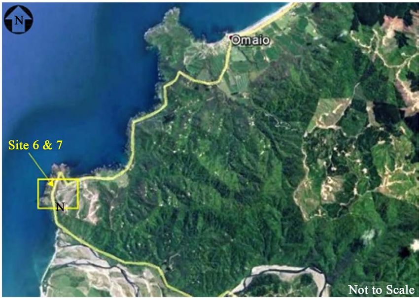
A. Indelicato

                                 Figure 1. SH35 Location (©Google map 2020).

                                 The corridor is consistent in nature with frequent bends and steep undulating
                              topography and geometry. Population stagnation and economic decline has been
                              a major concern for the area. For this reason, investment opportunities are availa-
                              ble to reverse the negative trend. The key customers that utilize the corridor are,
                              mainly, residents and freight operators. Furthermore, the proximity of surf beaches,
                              nature trails, camping sites, and cycle tourism add to the pressure on the local
                              road network.
                                 This portion of the New Zealand (NZ) Highways has been affected conti-
                              nuously by landslides (note that these occur along the entire corridor). A deeper
                              understanding of trigger mechanisms behind these landslides has the potential
                              to minimize the likelihood of landslide recurrence.

                              2. Methodology
                              The methodology used in this paper will focus initially on the study of the land-
                              slides occurred in 2018 along the SH35 corridor. The slips will be compared with
                              the rainfall data and earthquake events occurring within the same period to es-
                              tablish the correlation between the landslide triggering mechanism, and the
                              slope failure. The vibration caused by the freight passage cannot be correlated
                              with the landslide events as per their frequency along the state highway, however
                              their influence will be taken into consideration.

                              3. Geological Setting
                              The generalized regional geology of the Raukumara Peninsula is based on the

DOI: 10.4236/gep.2020.85021                        336            Journal of Geoscience and Environment Protection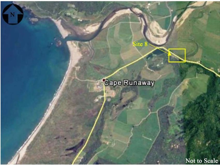
A. Indelicato

                              map published by Mazengarb (Mazengarb & Speden, 2000).
                                Two thirds of the corridor were built on the Waioeka terrain. This formation
                              consists mainly of indurated quartzofeldspathic, lithic sandstone, and mudstone
                              known as “greywacke”. This has been mapped as Torlesse Supergroup. Mono-
                              tonous sequences of indurated, interbedded sandstone and mudstone that are
                              typical of the Torlesse accumulate mainly in deep marine environments within
                              an accretionary prism (Mazengarb & Speden, 2000).
                                The Torlesse rocks are thrust over a younger Tikihore Formation. The contact
                              point is visible near the mouth of the Raukokore River. The Tikihore Formation
                              was deposited during the Tertiary. This formation is made of alternating fine-
                              grained sandstone, as well as mudstone with sandstone, and these, show typical
                              normal grading. It has been suggested a submarine fan or fans in deep marine
                              depositional environment for this Formation (Mazengarb & Speden, 2000).
                                Close to Cape Runaway, lies a Pliocene rock Formation. It is a fossiliferous
                              muddy sandstone with a thin basal conglomerate or limestone (i.e. Waikura Li-
                              mestone).
                                Elevated marine terraces are commonly seen along the coast, between Opotiki
                              and East Cape. These terraces represent erosion surfaces that were initially cut in
                              bedrock by marine processes, and subsequently raised by a tectonic uplift to as
                              high as 300 m above the present sea level. The terraces are commonly overlain
                              by a thin deposit of gravel and sand, which are capped by younger tephra, loess,
                              and other non-marine deposits (Ota et al., 1992).
                                Various faults also impact on the SH35. These run primarily East-West with a
                              recurrence of between 3500 and 5000 years (e.g., Kereu Fault, Haparapara Fault,
                              and Motu River Fault. GNS, 2018). Although they do not reoccur often, they still
                              play an important role in the geology of the area.

                              4. Climate
                              The study area is sheltered by high country to the West, South and East. Day to
                              day variations of the weather are largely determined by the direction of wind.
                              Most of the area receives a large part of its annual rainfall during periods of on-
                              shore north to northeast winds. These airstreams frequently have long trajecto-
                              ries over the warm Ocean to the north of New Zealand and, as a result, the air
                              flowing onto Bay of Plenty under these conditions, is very humid. These air-
                              streams produce widespread and heavy rain. The pattern of rainfall distribution
                              over the BOP largely reflects the region’s exposure to the main rain-bearing
                              north easterly winds. SH35 receive an average of 1300 - 1500 mm of rain per
                              year (Chappell, 2013).

                              5. Landslides in New Zealand
                              5.1. Classification and Terminology
                              The landslide terminology used in New Zealand follows Cruden and Varnes
                              (Cruden & Varnes, 1996). However, different terms are commonly used with

DOI: 10.4236/gep.2020.85021                       337             Journal of Geoscience and Environment Protection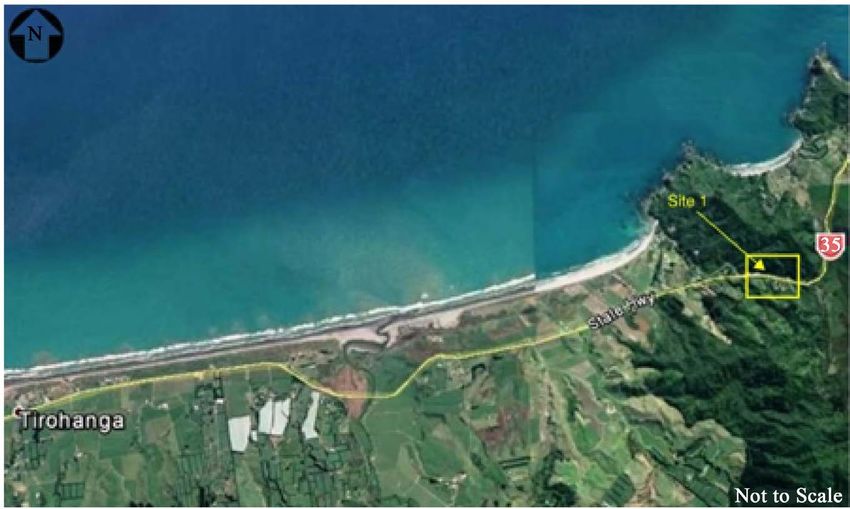
A. Indelicato
regards to the location of the slip according to the road location, i.e., over slips
and under slips. In most cases that this research considers here, these consist of
colluvium material deposited along the natural slope which has been cut to ac-
commodate the SH35.
Over slips refer to the slope failure that takes place above the road level. Under
the terminology from Hearn (Hearn & Hunt, 2011), over slips also include ero-
sion above the road (Sites 4 and 5) and rockfall above the road (Site 8).
Under slips are slope failures which develop below the highway road level,
and, according to the Hearn classification, those earth movements are classified
as erosion below the road (Hearn & Hunt, 2011).
5.2. Landslides along the SH35
5.2.1. Site 1
Site 1 is an under slip located at circa 7.7 km East of Tirohanga (Figure 2). The
first slip developed in 2016. The most recent slip surface occurred in early Sep-
tember 2018 (Figure 3). The scar is 6 - 7 m high and 13 m wide with a crown
that is 0.85 m away from the edge line. The pavement has been undercut so that
it is currently overhanging, (i.e. the slip surface is under the road surface). The
slope is made of silty clayey sand with an occasional gravel from the Quaternary
terrace deposit. Spring water is also present on the slipping surface.
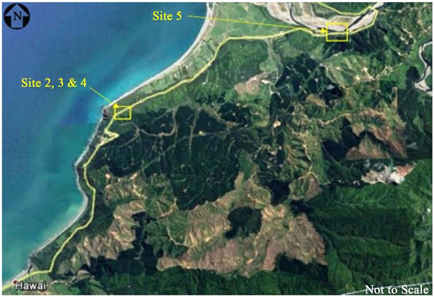
5.2.2. Sites 2 to 5
Sites 2, 3, and 4 are located at approximately 5.5 km NNE of Hawai (Figure 4).
Site 2 under slip occurred in mid-July 2018 (Figure 4) along the white edge
line of the carriageway (Figure 5). The width is approximately 35 m. Tension
cracks measure up to 100 mm wide with vertical displacements below 80 mm in
length. Based on the scouring on greywacke at the cut slope above the carriage-
way at road level, it is concluded that the slump area was likely within the water
runoff flow path. There were visible signs of erosion at the base of the cut slope.
Figure 2. Site 1 location (©Google Map 2018).
DOI: 10.4236/gep.2020.85021 338 Journal of Geoscience and Environment Protection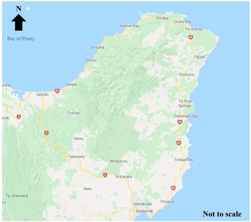
A. Indelicato

                                       Figure 3. Site 1 under slip (erosion in the base of the road).

                              Figure 4. Sites 2 to 5 (©Google Map 2018).

                                                Figure 5. Under slip site 2.

DOI: 10.4236/gep.2020.85021                   339              Journal of Geoscience and Environment Protection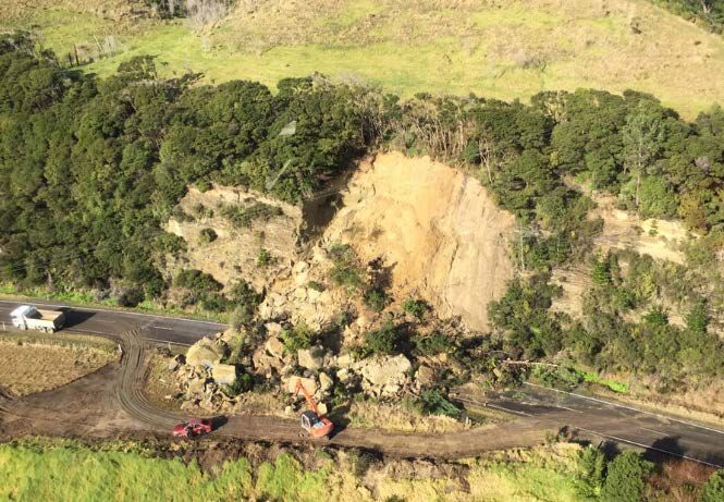
A. Indelicato

                                 The second episode occurred in the late August 2018 when the slip regressed
                              thus affecting a portion of the outer lane. This was damaged, causing restricted
                              traffic. The slip is 13 m wide, with tension cracks located at 1.5 m from the edge
                              line. The under slip affected only the top 6 m of the entire slope. The debris con-
                              sists mostly of residual soil from highly weathered greywacke.
                                 Close to the Site 2 under slip, other failures were recorded at the same time of
                              the year between 500 m and 6 km away from the previous under slip (Figure 4).
                                 Site 3 under slip measures 12 m wide with 2 m long tension cracks located 1.1
                              m away from the road edge line. The slip affected only the top 6 m of the slope
                              as debris was likely stopped by the thick vegetation present below.
                                 Site 4 over slip released a fair amount of debris estimated to be between 400 to
                              500 m3. The geometry follows what appears to be a wedge feature within the re-
                              sidual soil. Spring water was still present at the base of the gully (Figure 6).
                                 Site 5 over slip is located approximately 9.5 km NNE of Hawai and measures
                              22 m in height and 10 - 12 m in width. Debris is mostly residual soil that overlies
                              a heavy folded greywacke. The total debris is estimated to be approximately 200
                              m3. Some blocks are overhanging and still pose a hazard to the corridor and traf-
                              fic.

                              5.2.3. Sites 6 and 7
                              Site 6 slip is located approximately 4.5 km of Omaio (Figure 7). The occurrence
                              was at the end of August 2018. The scarp measures 13 m in width and 10 - 12 m
                              in height. The failure surface slopes at 75˚ in the upper portion and, at the base,
                              it is almost vertical. The debris is almost entirely residual soil from completely
                              weathered greywacke. No rocks are present within the soil matrix. Tension
                              cracks are visible at approximately 1.7 m from the center line and 1.1 m from the
                              crown.

                                                 Figure 6. Over slip site 4.

DOI: 10.4236/gep.2020.85021                       340              Journal of Geoscience and Environment Protection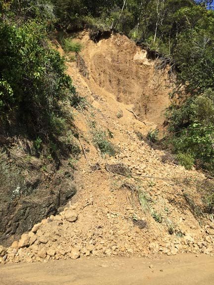
A. Indelicato

                                      Figure 7. Sites 6 & 7 (©Google Map 2018).

                                 Site 7 slip is located 500 m north of Site 6. It occurred early September 2018
                              (Figure 7). The area affected by the slope failure measures 15 m in height and 50
                              m in width and consists of multiple semi-rotational slips. Most of the displaced
                              material is still intact; it did not turn into loose material. The material consists of
                              loose to medium dense clayey silty fine sand, being dark yellowish orange in
                              color. Adjacent land use consists of forestry. The area located immediately up-
                              slope appears to have been recently harvested. As the vegetation was still devel-
                              oping, the shallow soils were likely reworked and left loose undermining the sta-
                              bility of the overall slope.

                              5.2.4. Site 8
                              On June 20th, 2018, an earthquake of 4.7 m centered 4 km deep and approx-
                              imately 35 km southwest of the current rock fall location was recorded. The
                              seismic event may have damaged the already marginally stable site and pushed it
                              close to failure.
                                 One month later, the heavy rain has triggered the rock fall which affected an
                              area 30 m wide by 20 m high located approximately 1 km East of Cape Runaway
                              (Figure 8). The geology of the area shows the failing slope is made of weak to
                              moderately strong sandstone with local tuff beds and marine sandy cemented
                              deposits (Figure 9). Jointing daylights on the road are at an angle of 45˚. Bed-
                              ding plane appears to dip gently back into the slope. Sub-vertical cracks have
                              been identified at the time of failure, and these were likely responsible for the
                              rock fall.

                              6. Trigger Mechanisms
                              6.1. Definition
                              Landslides can have several causes including geological, morphological, physical,
                              and human ones (Cruden & Varnes, 1996), however, there is only one known
                              trigger (Varnes, 1978).

DOI: 10.4236/gep.2020.85021                        341             Journal of Geoscience and Environment Protection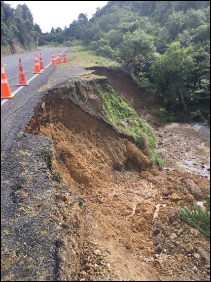
A. Indelicato

                                   Figure 8. Site 8 (©Google Map 2018).

                                   Figure 9. Site 8 rockfall (image courtesy of J. Griffith).

                                By definition, a trigger is an external stimulus, for example, an intense rainfall,
                              an earthquake, a volcanic eruption, storm waves, or rapid stream erosion. All
                              these stimuli can cause a near-immediate landslide response by rapidly increas-
                              ing the stress on the slope materials, or by strength reduction of these materials
                              (Wieczorek, 1996).

                              6.2. Rainfall
                              The rain data was collected from two rain stations provided by BOP East Coun-
                              cil. Ohope 5 station is located 9.4 km East of Whakatane. The Hicks Bay station
                              is 3.8 km northeast of the Hicks Bay settlement. Another station has been used
                              by NIWA (Haparapara) which is located far away from the coast within the
                              Raukumara Ranges at an altitude of 1040 m above the sea level. Despite its loca-

DOI: 10.4236/gep.2020.85021                         342               Journal of Geoscience and Environment Protection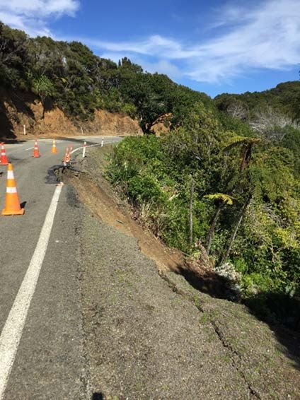
A. Indelicato

                              tion, Haparapara rain gauge has been very useful in providing additional data.
                                 Ohope 5 data has been used for the landslip at Houpoto, Whitianga, and Oroi.
                              On July 12, no rain was recorded. However, two days before the landslide event,
                              a cumulative 11.5 mm of rainfall was recorded (i.e., 5.75 mm/day). Severe rain-
                              fall was recorded on August 31 during the landslides at Houpoto and Whitianga
                              with 91 mm falling within two days (45.5 mm/day), with the station at Hapara-
                              para recording 143 mm the day before. On September 4, no major rainfall was
                              recorded, whereas the data from six days before the landslip shows a cumulative
                              rainfall of 101.3 mm (17 mm/day).
                                 Hicks Bay station recorded 0 mm of rainfall on the 22 of July, while the day
                              after it recorded 34.8 mm. For Waihau, the week before the landslip it recorded
                              181.6 mm, which approximately equals 26 mm. At Haparapara, the rainfall rec-
                              orded on July 22nd was 63 mm.
                                 In some cases, rainfall does not match the time of the landslides. The differ-
                              ence may be related to the distance of the station from the actual location of the
                              landslide (i.e., 50 - 60 km away). It appears that the Cape Runaway rockfall may
                              have been triggered by a similar rainfall recorded the day before, because the
                              weather front was likely moving East to West. However, it is also plausible that
                              the intensity of the rainfall decreased by the time the bad weather reached Hicks
                              Bay Station. This aligns with the rainfall records from the Haparapara station.
                              Although rainfall is considered the main triggering factor, the data from the
                              weather stations, albeit poorly reliable, does not confirm it.

                              6.3. Earthquakes
                              An active fault is where movement occurred within the last 125,000 years (Ma-
                              zengarb & Speden, 2000).
                                 Among the faults of the Raukumara Peninsula, the only one that has been
                              studied in detail is the Pakarae Fault which has moved a total of 16 m vertically
                              in three separate events within the last 5500 years (Mazengarb & Speden, 2000).
                                 The main faults affecting the SH3 are the Kereu Fault, the Haparapara Fault,
                              and the Motu River Fault, and these have a recurrence between 3500 and 5000
                              years (GNS, 2018).
                                 The timeline of these earthquakes cannot be related to the landslides that oc-
                              curred in 2018, where the only seismic event that may have affected the area was
                              the one that occurred not far from Site 8. However, the actual rock fall happened
                              significantly later, and therefore does not seem to be directly connected to the
                              slope failure.

                              6.4. Freight’s Vibration Effects
                              Despite the low level of importance, SH35 is busy by the numerous freights that
                              transport wood logs from the Raukumara peninsula to the Tauranga Harbor.
                                 In a soil medium, grains bind each other with a strength that is influenced by
                              cohesion and suction, and this changes with the saturation of the ground espe-
                              cially during heavy rainfall events. Saturation is not the only factor that influ-

DOI: 10.4236/gep.2020.85021                       343            Journal of Geoscience and Environment Protection
A. Indelicato
ences the grain bond. Heavy loads from freight can also propagate into the ground
and affect the behavior of the grains within the soil (Kusumawardani et al., 2018).
Vibrations are caused by the interaction between the axles of the vehicle and
the different types of surface unevenness. The level of vibration increases directly
with the speed of the vehicles (Ducarne et al., 2017).
The oscillation amplitude is related to the speed of trucks. Furthermore, an
increase of the axial load will increase the force action on the roadbed (Patriaev,
2016). Other factors that influence the road vibration are the condition of the
road, suspension type, and soil type stratification (Hunaidi, 2000).
Based on a previous study for SH35, the Highway traffic that induced ground
vibration generated a forced vibration of the pavement-structure-subgrade sys-
tem with the dominant frequency between 10 and 15 Hz (Hajek et al., 2006).
There may be some merit in carrying out a study of the impact that traffic in-
duced vibrations have on the road, and specifically, the under slopes.
7. Conclusion
The landslides recorded in the Bay of Plenty East on SH35 show that this type of
hazard is frequent within the corridor. Most of the failures occurred on the
mountain cuts to accommodate the state highways.
Despite the presence of some active faults and the poor availability of the rain-
fall data, heavy rainfall has been considered the main landslide trigger affecting
the Raukumara Peninsula during the winter season. However, the importance of
the vibration effects that are caused by the passing freight should not be unde-
restimated especially for the under-slip section of SH35. The amplitude of vibra-
tions caused by freight ranges between 0.0005 and 0.2 g (Hunaidi, 2000). Ac-
cording to recent studies of earthquake-triggered landslides, even a lower limit
of PGA can trigger a landslide (i.e., between 0.05 and 0.07 g). Occasionally, land-
slides were reported to have been induced by yet a lower threshold (Wang et al.,
2010). Therefore, it is suggested that the freights moving along the SH35 may
significantly contribute to the instability of the slope specifically for those below
the road level.
As most of the slope failures occur in the wet season, rainfall can be consi-
dered the main trigger. However, the freight vibrations have an important role
that the author defines it as accessory trigger mechanism.
Given that the weather condition would likely worsen due to global warming
effects and the heavy freight traffic will continue, future failures are likely to be
expected along the SH35. For this reason, the author suggests further studies
to the effect of freight vibration onto road slopes and possible mitigation mea-
sures.
Acknowledgements
The author wishes to thank David Dobson and Tafu Tuiloma for the editing,
Beca Bay of Plenty East NOC team for their support, as well as Higgins and
NZTA for their kind permission to publish the material of this paper.
DOI: 10.4236/gep.2020.85021 344 Journal of Geoscience and Environment ProtectionA. Indelicato
Conflicts of Interest
The author declares no conflicts of interest regarding the publication of this pa-
per.
References
Chappell, P. R. (2013). The Climate and Weather of Bay of Plenty. NIWA Science and
Technology Series, No. 62.
Cruden, D. M., & Varnes, D. J. (1996). Landslides Investigation and Mitigation. Chapter
3-Landslide Type and Processes. Transportations Research Board, No. 247, 36-75.
Ducarne, L., Ainalis, D., & Kouroussis, G. (2017). Ground Vibration Generated by the
Passing of a Truck on a Speed Bump. Rhodes Island, Greece: 6th ECCOMAS Thematic
Conference on Computational Methods in Structure Dynamics and Earthquake Engi-
neering. https://doi.org/10.7712/120117.5541.17137
GNS (2018). Active Fault Database. https://data.gns.cri.nz/af/
Hajek, J. J., Blaney, C. T., & Hein, D. K. (2006). Mitigation of Highway Traffic-Induced
Vibration. Charlottetown: Annual Conference of the Transportation Association of
Canada.
Hearn, G. J., & Hunt, T. (2011). Slope Management. Geological Society, London, Engi-
neering Geology Special Publication, 24, 269-284. https://doi.org/10.1144/EGSP24.17
Hunaidi, O. (2000). Traffic Vibrations in Buildings. Construction Technology Update
No. 39.
Kusumawardani, R., Nugroho, U., Fansuri, M. H., Mindiastiwi, T., Yuniarti, W., & Hilmi,
A. S. (2018). The Impact of Vehicle Load Inducing Vibrations on the Subgrade Soil
Particle Acceleration. Journal of Engineering Science and Technology, 13, 1440-1450.
Mazengarb, C., & Speden, I. G. (2000). Geology of the Raukumara Area (60 p.). Institute
of Geological and Nuclear Science 1:250 000 Geological Map 6. Lower Hutt, New
Zealand: Institute of Geological and Nuclear Sciences Limited.
New Zealand Transportation Authority (NZTA) (2018). Opotiki to Gisborne via East
Cape. Corridor Management Plan 2018-2028.
Ota, Y., Hull, A. G., Iso, N., Yasutaka, I., Moriya, I., & Yoshikawa, T. (1992). Holocene
Marine Terraces on the Northeast Coast of North Island, New Zealand, and Their
Tectonic Significance. New Zealand Journal of Geology and Geophysics, 35, 273-288.
https://doi.org/10.1080/00288306.1992.9514521
Patriaev, A. (2016). The Vibration Impact of Heavy Freight Train on Roadbed. Procedia
Engineering, 143, 1136-1143. https://doi.org/10.1016/j.proeng.2016.06.143
Varnes, D. J. (1978). Slope Movement Types and Processes. In R. L. Schuster, & R. J. Kri-
zek (Eds.), Special Report 176: Landslides: Analysis and Control (pp.12-33). Washing-
ton DC: TRB, National Research Council.
Wang, X., Nie, G., & Wang, D. (2010). Research on Relationship between Landslides and
Peak ground Accelerations Induced by Wenchuan Earthquake. Chinese Journal of
Rock Mechanics and Engineering, 29, 82-89.
https://doi.org/10.1007/s11589-010-0719-5
Wieczorek, G. F. (1996). Landslides Investigation and Mitigation. Chapter 4-Landslide
Triggering Mechanisms. Transportations Research Board, No. 247, 76-90.
DOI: 10.4236/gep.2020.85021 345 Journal of Geoscience and Environment ProtectionYou can also read