The length of coastlines in Ptolemy's Geography and in ancient periploi - HGSS
←
→
Page content transcription
If your browser does not render page correctly, please read the page content below
Hist. Geo Space Sci., 9, 9–24, 2018
https://doi.org/10.5194/hgss-9-9-2018
© Author(s) 2018. This work is distributed under
the Creative Commons Attribution 4.0 License.

           The length of coastlines in Ptolemy’s Geography and
                            in ancient periploi
                                                     Dmitry A. Shcheglov
             S.I. Vavilov Institute for the History of Science and Technology, St. Petersburg, Russian Federation
                               Correspondence: Dmitry A. Shcheglov (shcheglov@yandex.ru)

           Received: 2 July 2017 – Revised: 22 November 2017 – Accepted: 2 December 2017 – Published: 1 February 2018

       Abstract. The lengths of the coastlines in Ptolemy’s Geography are compared with the corresponding values
       transmitted by other ancient sources, presumably based on some lost periploi (literally “voyages around or
       circumnavigations”, a genre of ancient geographical literature describing coastal itineraries). The comparison
       reveals a remarkable agreement between them, suggesting that Ptolemy relied much more heavily on these or
       similar periploi than it used to be thought. Additionally, a possible impact of Ptolemy’s erroneous estimate of
       the circumference of the Earth is investigated. It is argued that this error resulted in two interrelated distortions
       of the coastal outlines in Ptolemy’s Geography. First, the north–south stretches of the coast that were tied to
       particular latitudes are shown compressed relative to the distances recorded in other sources in roughly the same
       proportion to which Ptolemy’s circumference of the Earth is underestimated relative to the true value. Second,
       in several cases this compression is compensated by a proportional stretching of the adjacent east–west coastal
       segments. In particular, these findings suggest a simple explanation for the strange shape of the Caspian Sea in
       Ptolemy’s Geography.

1   Introduction                                                    emerus in his Geographical Sketch (the 1st century AD) and
                                                                    by Pliny the Elder in the geographical books of his Natural
Classics (or studies of Greco-Roman antiquity), which is            History (AD 77–79). The objective of the present study is to
the field that the history of ancient geography and cartog-         fill this gap. My contention is that this comparison can shed
raphy belongs to, is a very old discipline. So, as time goes        some new light on Ptolemy’s modus operandi and the genesis
by, the chance to find something really new in this field, or       of his Geography.
to do something that nobody has ever done before, tends
to zero. Ptolemy’s Geography (ca. AD 150) is a happy ex-
                                                                    2   Periploi among the sources of Ptolemy’s
ception to this tendency. Although the Geography is one
                                                                        Geography
of the most famous and often-studied works in the history
of cartography, its origins still remain an enigma. How-
                                                                    Ptolemy’s Geographical Guide, or simply the Geography,
ever, in the last decade, after the publication of its new edi-
                                                                    was essentially a description of the world map in terms of
tion by Stückelberger and Graßhoff (2006), Ptolemy’s Ge-
                                                                    spherical coordinates (latitude and longitude in degrees) as-
ography has seen an upsurge of scholarly interest. Numer-
                                                                    signed to each of the 6300 listed localities.1 However, it is
ous researchers have developed a wide array of different
                                                                    clear that only some of these coordinates could have been
methodological approaches to studying its nature and gen-
                                                                    based on astronomical observations (e.g. the latitudes of the
esis (e.g. Isaksen, 2011, 2013; Marx, 2011, 2016; Heß, 2016;
Shcheglov, 2017; Graßhoff et al., 2017; Arnaud, 2017; De-               1 Consequently, the term “Ptolemy’s Geography” may be used
faux, 2017). One of the main approaches is a comparison             synonymously with “Ptolemy’s map” when referring to a map re-
with other ancient sources. Surprisingly, until this day no-        constructed from the coordinates recorded in the text. These coor-
body has ever tried to compare Ptolemy’s Geography with             dinates are now available in an electronic database attached to the
the ample data on coastline length provided mostly by Agath-        edition of the Geography by Stückelberger and Graßhoff (2006).

Published by Copernicus Publications.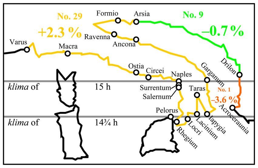
10                                   D. A. Shcheglov: The length of coastlines in Ptolemy’s Geography and in ancient periploi

major cities: Alexandria, Rhodes, Athens, Rome, Massalia,               ever, deserve a more thorough examination elsewhere. Fortu-
etc.). Ptolemy’s predecessors and possible sources described            nately, thanks mainly to the Geographical Sketch by a certain
geographic space mostly in terms of distances measured in               Agathemerus (Diller, 1975) and to Books III–VI of Pliny’s
customary units (Greek stades, Roman miles, etc.).2 It is               Natural History (Jan and Mayhoff, 1892), as well as to some
reasonable to suppose, therefore, that, with few exceptions,            other sources, we have a set of values for the total coast-
Ptolemy’s coordinates were derived from distances converted             line lengths of the major regions as recorded by the most
to angular units (Cuntz, 1923, p. 110; Knapp, 1996, p. 30–              famous ancient geographers: Eratosthenes (the 3rd quarter
35; Graßhoff et al., 2017; Arnaud, 2017, pp. 3, 14–20). This            of the 3rd century BC),7 Artemidorus of Ephesus (ca. 104–
makes comparison of Ptolemy’s Geography with other sur-                 100 BC),8 Marcus Vipsanius Agrippa (ca. 12 BC),9 Isidore
viving sources a promising way to investigate its organization          of Charax (around the turn of the 1st centuries BC and AD),
and genesis. Interestingly, there are a lot of studies compar-          and some others. These values evidently derive from some
ing Ptolemy’s distance data with the Roman itineraries (or              lost periploi.
descriptions of the land routes),3 but only a few attempts to              This data set covers the largest part of the then-known
compare them with the Greek periploi.4                                  world (Figs. 2 and 3). First of all, Artemidorus, Isidore, and
   Periploi (sing. periplus) is a genre of ancient geographical         Agrippa give the lengths of the coastlines of the “Inner” Sea
literature describing coastlines in the form of a linear succes-        (Mediterranean, Black, and Azov seas) as a whole and as
sion of stopping points and intervening distances. Periploi             divided between the three continents: Europe from the Pil-
are considered to be “the standard basis of ancient descrip-            lars of Hercules (or Calpe, i.e. Gibraltar) to the mouth of the
tive geography” (Purcell, 2012, p. 1107).5 Many ancient ge-             Tanais (Don), Asia from the Tanais to the Canobic (west-
ographers – Artemidorus, Strabo, Pomponius Mela, Pliny                  ernmost) mouth of the Nile, and Libya (Africa) from this
the Elder (in Books III–VI of his Natural History), Diony-              mouth to Tingis (Tangier). The same geographers and some
sius Periegetes, etc. – presented their works in the form of            other authors give the perimeters of the major peninsulas (the
periploi, even though they actually did not confine their nar-          Pyrenean, the Italian, the Arabian), seas or gulfs (the Persian
ratives to the coasts. Ptolemy himself emphasizes (Geogr.               Gulf and the so-called “second” and “third” gulfs of Europe
1.18.6) that it is much easier to indicate the positions of the         i.e. roughly speaking, the Adriatic, Ionic, and Aegean seas
coastal cities than of the inland ones. It is reasonable to sup-        and the Red, Black, Azov, and Caspian seas), and the largest
pose, therefore, that in many respects it was periploi that pro-        islands. The fact that different authors reproduce almost the
vided the foundation for his map of the world.                          same or similar set of values suggests that these data were
   Only a few periploi survived from antiquity and only                 regarded as a special category to be included in a geographi-
four of them provide detailed information on distances: three           cal treatise. For the sake of completeness, we will add to this
Periploi of the Pontus Euxinus (Black Sea) and the Stadias-             set several values of the total coastline lengths reported by
mus of the Great Sea (Mediterranean).6 These sources, how-              the surviving “detailed” periploi: Pseudo-Arrian’s Periplus
    2 The length of the stade is a vexed issue. The majority of an-
                                                                        and the Stadiasmus, as well as by Strabo’s Geography (ca.
                                                                        AD 23), our main source on its subject matter (Radt, 2003–
cient sources use the ratio of 1 Roman mile (for which the standard
                                                                        2011).
notation is m.p. or mille passuum) to 8 Greek stades. This ratio is
used throughout the present paper. Since the Roman mile measures
about 1480 m, 1 stade is equal to ca. 185 m. For a detailed discus-     from Aradus to Miletus including the adjacent islands of Cyprus and
sion with references to relevant literature, see Shcheglov (2016b,      Crete. The most reliable edition is still Müller (1855, p. 427–563);
p. 694–701).                                                            a new edition is being prepared by Pascal Arnaud. These periploi
    3 Cuntz (1923), Spaul (1958, p. 5–7), Seabra Lopes (1995–           may be called “detailed” in the sense that, unlike other surviving
1997), Knapp (1996), Meuret (1998), Gómez Fraile (2005), Urueña         periploi, they divide the route into hundreds of course legs with the
Alonso (2014a, b).                                                      median length of ca. 90 stades or 16–17 km. On the ancient methods
    4 Mittenhuber (2012) compares Ptolemy’s Hispania (i.e. the          of maritime distance estimation, see Arnaud (1993).
Iberian Peninsula) with the distance data from the so-called Artemi-        7 Eratosthenes was probably the most famous ancient geographer
dorus papyrus, while Marx (2016) compares Ptolemy’s Atlantic            before Ptolemy. His geographical treatise has survived only in frag-
coast of Africa with the distance data from Pliny’s Natural History.    ments; for the editions, see Berger (1880) and Roller (2010).
    5 On periploi as one of the basic forms of geographical descrip-        8 Schiano (2010).
tion in antiquity, see Janni (1984).                                        9 Marcus Vipsanius Agrippa (63–12 BC) was the right arm of the
    6 Two Periploi of the Pontus Euxinus (Black Sea) composed           emperor Augustus. According to Pliny’s testimony (Natural His-
by Menippus of Pergamon (the end of the 1st century BC) and             tory 3.17), he left behind an unfinished geographical work which, as
Flavius Arrian (the beginning of 2nd century AD) served as the          most scholars believe, served as the basis for a world map displayed
sources for the third and fuller Periplus known under the name of       in the Porticus Vipsania in the centre of Rome (before AD 14). The
Pseudo-Arrian (3rd century AD). The standard edition of these three     map was accompanied by explanatory notes with an account of di-
periploi is Diller (1952, p. 103–146). The anonymous Stadiasmus of      mensions and boundaries of 24 regions of the world. These notes
the Great Sea (1st century AD; for this dating, see Uggeri, 1996) de-   have come down to us only in fragments; the standard edition is
scribes the coasts of Africa from Alexandria to Carthage and of Asia    Klotz (1931).

Hist. Geo Space Sci., 9, 9–24, 2018                                                            www.hist-geo-space-sci.net/9/9/2018/
D. A. Shcheglov: The length of coastlines in Ptolemy’s Geography and in ancient periploi                                                11

   The objective of this paper is to compare this data set with       uratively speaking, Ptolemy’s map had “low resolution”: it
the lengths of the corresponding coastlines in Ptolemy’s Ge-          could reproduce general outlines of large objects, but was
ography. But before attempting the comparison there are sev-          quite inaccurate in details. For this reason, when comparing
eral methodological issues we need to discuss.                        Ptolemy’s data with the distances reported by other sources,
                                                                      it makes sense to consider only those applying to relatively
3   Method of comparison                                              long intervals. It also needs to be born in mind that, owing
                                                                      to the peculiarities of the map, close matches can hardly be
How can we measure the lengths of the coastlines in                   expected from this comparison.
Ptolemy’s work? My contention is that the simplest and most              The text of Ptolemy’s Geography has been handed down
natural way would be to take Ptolemy’s Geography as what it           to us in two recensions: 4 and  (Fig. 1).12 Both of them
essentially is, namely as a catalogue of spherical coordinates.       descend from antiquity, but none of the extant manuscripts
The distance between two points specified by these coordi-            dates earlier than the late 13th century. The 4 recension is
nates is an arc of the great circle that can be calculated using      considered to be earlier and more authentic, but it is repre-
the rules of spherical trigonometry.10 Accordingly, I propose         sented by the sole manuscript Vaticanus Graecus 191 (ca.
to calculate the length of the coastlines in Ptolemy’s Geogra-        AD 1295) which omits all coordinates for the eastern half of
phy as the sum of individual arcs joining coastal points mul-         the map (i.e. for the whole Asia, except for Asia Minor, Ar-
tiplied by the length of a degree of the great circle which he        menia, and Asiatic Sarmatia) and contains quite a few scribal
defines as 500 stades (Geogr. 1.7.1, 11.2).                           errors. The  recension is apparently secondary to 4, but it
    It is important to emphasize that actually next to nothing is     includes the majority of the manuscripts.13 In view of these
known about how Ptolemy worked with his sources and how               circumstances, when comparing Ptolemy’s data with the dis-
he converted their distance data into coordinates (Graßhoff           tances recorded in other sources, both recensions should be
et al., 2017, p. 2, 6–7; Defaux, 2017, p. 12, 255). It is hard        taken into account, but 4 should be regarded as more reli-
to imagine that he would have calculated the coordinates for          able.
each of the 6000 points listed in his Geography. It would be
more reasonable to assume that calculations may have been
                                                                      4   Comparison of the coastline lengths in Ptolemy’s
performed only for the most important points, whereas all
                                                                          Geography and in other sources
others were localized by means of simpler methods, for ex-
ample, Pythagoras’ theorem and/or a simple ruler; cf. simi-
                                                                      Let us turn to the sources. All data needed for comparison
larly Spaul (1958, p. 5–7) and Graßhoff et al. (2017, p. 1, 16,
                                                                      are given in Table 1, which constitutes the core of this pa-
25).
                                                                      per, and are illustrated by Figs. 2–7. Table 1 compares the
    Ptolemy’s coordinates are specified with precision up to
                                                                      coastline lengths derived from Ptolemy’s coordinates (in 4
50 . This, however, must not mislead us about the accuracy
                                                                      and ) with the corresponding distances given in the other
of his data. The precision of Ptolemy’s coordinates corre-
                                                                      sources, presumably based on periploi.14 Also, the table
lates clearly with the density of the points on his map: its
                                                                      shows how much Ptolemy’s values deviate from those of the
“rarest” parts at the periphery (such as Asian Scythia or Inner
Libya) have the highest percentage of coordinates in whole            ordinates in integer degrees, without fractions, are the most fre-
degrees, but as we approach the Mediterranean, the fractions          quent, those with 1/2◦ are less frequent, those with 1/3 or 2/3◦
of a degree become increasingly more frequent and smaller.            are still less, those with 1/4 or 3/4◦ and 1/6 or 5/6◦ are still less
In other words, Ptolemy’s coordinates can be precise not so           again, and those with 1/12, 5/12, 7/12 or 11/12◦ are the rarest;
much because his sources were accurate, but rather in or-             see Wurm (1931, p. 25–27), Marx (2011, p. 30–36), Isaksen (2011,
der to fit many points in a confined space. Statistical anal-         p. 262–264, 2013, p. 48–50).
                                                                         12 For a detailed discussion of the manuscript (MSS) tradition,
ysis of the frequency of different fractions of a degree used
in Ptolemy’s coordinates shows that he tended to round all            see e.g. Schnabel (1938), Stückelberger and Graßhoff (2006, p. 30–
values to the largest possible fractions.11 It means that, fig-       34), Burri (2013, p. 63–93), for a good synopsis, see Defaux (2017,
                                                                      p. 67–81).
  10 The distance between points A and B situated on a sphere can        13 See e.g. Cuntz (1923, p. 15–16), Schnabel (1938, p. 44, 55–57),
be calculated by the formula cos SAB = cos 1λAB · sin(90◦ − ϕA ) ·    Burri (2013, p. 540–542). Polaschek (1965, cols. 717, 742–744) and
sin(90◦ −ϕB )+cos(90◦ −ϕA )·cos(90◦ −ϕB ), where SAB is the dis-      Berggren, Jones (2000), p. 43–45 argued that the  recension repre-
tance between points A and B expressed in degrees of the great cir-   sents a post-Ptolemaic Byzantine revision, whereas codex Vaticanus
cle, 1λAB is the longitudinal interval between them, ϕA and ϕB        Graecus 191 is the only piece of Ptolemy’s genuine text. However,
are their latitudes. Certainly, Ptolemy did not have trigonometric    I see no sufficient grounds for such a radical position; see similarly
formulas in their modern form, but the theorems of Menelaus that      Defaux (2017, p. 80–81).
he used to solve similar problems in the Almagest were an ancient        14 All Ptolemy’s coordinates are taken from the electronic
equivalent of them (Neugebauer, 1975, p. 21–30).                      database attached to the newest edition of the Geography (Stück-
  11 The frequency of different fractions of a degree in Ptolemy’s    elberger and Graßhoff, 2006) and are appended to the present paper
catalogue of coordinates conforms to a normal distribution: the co-   as Excel files in the Supplement.

www.hist-geo-space-sci.net/9/9/2018/                                                            Hist. Geo Space Sci., 9, 9–24, 2018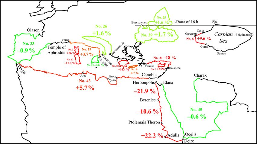
12                                    D. A. Shcheglov: The length of coastlines in Ptolemy’s Geography and in ancient periploi

                                                                         the 5–10 % difference between them as small enough to sug-
                                                                         gest a common origin (Cuntz, 1923, p. 120–122, 144–145;
                                                                         Urueña Alonso, 2014a, p. 164, 169–170; Marx, 2016, p. 33–
                                                                         34). But for a more robust assessment, it would be infor-
                                                                         mative to compare the differences between Ptolemy and the
                                                                         other sources with the differences between the two recen-
                                                                         sions of Ptolemy’s own work (see Table 1 and Figs. 5, 6). A
                                                                         convenient benchmark for this comparison is provided by the
                                                                         measurements of the “Inner” Sea (Mediterranean and Black
                                                                         seas without the Azov Sea).16 In the 4 recension, its perime-
Figure 1. The outlines of the Mediterranean Sea according to the         ter measures 133 792 stades, which is 2.8 % longer than ac-
4 and  recensions of Ptolemy’s Geography (Italy, the Balkans,           cording to Artemidorus (130 120, no. 50 in Table 1), but in
and the Aegean Sea are taken as an example). This and all the            it is 1.8 % longer (136 231) than in 4. Remarkably, in a num-
other maps in the paper are drawn using the projection attributed by     ber of cases the differences between 4 and  are appreciably
Ptolemy to Marinus of Tyre (Geogr. 1.20.3–5), whom he introduces         larger than those between 4 and the other sources: Europe
as his immediate predecessor and the primary source of information       from Calpe to the Tanais (no. 48 in Table 1), Hispania (33),
(Geogr. 1.6.1). In modern terms, it is an equidistant cylindrical pro-
                                                                         Italy (29), the “second gulf” of Europe (26), and the Red Sea
jection, in which the ratio between equal latitudinal and longitudinal
intervals is represented as 5 : 4.
                                                                         (28). If we still believe that 4 and  are, despite all the dis-
                                                                         agreements between them, two versions of the same work by
                                                                         the same author, the similarity between Ptolemy’s 4 values
                                                                         and those reported by the other sources cannot be dismissed
other sources, and how much  deviates from 4, both in
                                                                         as a coincidence.
terms of stades and in terms of percentage.
                                                                             It makes sense to take a closer look at the outliers. First
   What conclusions can be drawn from this comparison?
                                                                         of all, however obvious it may seem, it is worth noting that,
First of all, our sample clearly falls into two parts: shorter and
                                                                         when ancient sources give different estimates for the same
longer distances. Islands and other small features (such as
                                                                         coastline, Ptolemy’s data cannot agree with all of them. For
Peloponnesus or no. 18 in Table 1, the Great Syrtis or nos. 7
                                                                         instance, when Ptolemy’s data match one of the two known
and 17, etc.) or relatively short coastal stretches exhibit little
                                                                         values for the perimeter of Arabia (no. 45: 38 120 stades),
similarity between Ptolemy’s data and the periploi data (the
                                                                         they must naturally disagree with the other (no. 44: 32 000).
only exceptions are Sicily nos. 15 and 16, Crete no. 8, and
                                                                         The same is true for the Great Syrtis (nos. 7 and 17), the
Illyria nos. 1 and 9; Figs. 3 and 7) This result accords with
                                                                         Maeotis (22, 25), Hispania (33, 38), the Pontus Euxinus (35–
the fact that Ptolemy’s map had a low resolution and was in
                                                                         37, 39), Africa (40–43), and the Mediterranean without the
principle incapable of representing small features accurately.
                                                                         Pontus (49, 50). Taking this into account, only two out-
   However, for longer distances, with a threshold being ap-
                                                                         liers stand out: the Red Sea coast of Arabia (no. 27) and
proximately at 10 000 stades, the pattern changes radically. It
                                                                         the Mediterranean coast of Africa (nos. 40–43). The esti-
is instructive to remember that, with only a few exceptions,
                                                                         mated 14 000 stades for the Arabian coast, repeated by Er-
these coastlines are very long and have very complex geom-
                                                                         atosthenes, Artemidorus, and Agrippa, goes back as far as
etry. In these circumstances, one can hardly expect any sim-
                                                                         to Alexander’s commander Anaxikrates and was regarded as
ilarity between Ptolemy’s figures and the periploi figures at
                                                                         “too much” (ἐπὶ πλέον) already by Strabo (16.4.4 C768).
all. Nevertheless, the correspondences between them are so
                                                                         But it seems that the best way to explain a drastic reduction of
numerous and so close (Fig. 4) and their geographical cover-
                                                                         this coast by 22 % in Ptolemy’s Geography would be to link
age is so wide (Figs. 2 and 3) that this can reasonably be re-
                                                                         it to his adoption of an erroneous value for the circumference
garded as something more than just a series of coincidences.
                                                                         of the Earth (see below Sect. 5). The case of Africa seems to
   Figure 4 shows that in most cases the differences between
                                                                         be more complicated: Ptolemy’s distance is 5 % shorter than
Ptolemy’s data and the periploi-based sources fall between
                                                                         the Stadiasmus’ value for the coast between Alexandria and
+4 and −1 %.15 How can we interpret these values? Is it
                                                                         Utica (no. 30), but it is 5.66 % longer than the largest value
a lot or not? Previous researchers who compared Ptolemy’s
                                                                         recorded by Pliny (no. 43) for the coast between Canobus
data with the distances recorded in other sources regarded
                                                                         and Tingis. Yet, it is remarkable that Pliny calls this value
   15 Of course, it is possible to find many contradictions between      “the average of all the various accounts” (6.208: ut media ex
Ptolemy’s data and distances reported by other sources, but there
is no reason to expect them to match always and everywhere. For            16 It is important to emphasize that Artemidorus, followed by the
example, Pliny gives evidently incredible and fictional values for       majority of other ancient authors, estimated the circumference of
the coastlines of Germania (4.98 = Agrippa F 21; see Riese, 1878,        the Maeotis (Azov Sea) at 9000 stades, whereas Ptolemy may have
p. 5) and Gaul (4.105 = Agrippa F 23 Riese = F 40 Klotz): 20 000         adopted an alternative estimate of 11 248 stades attested by Pliny
and 14 000 stades, respectively.                                         4.78.

Hist. Geo Space Sci., 9, 9–24, 2018                                                             www.hist-geo-space-sci.net/9/9/2018/
Table 1. Comparison of the coastline lengths in Ptolemy’s Geography and in the other sources.
No. Coastline of Periploi-based sources Ptolemy Deviation of Ptolemy’s distance values from Difference between
the values given by the other sources 4 and
Ancient geographer Source Distance (D) Distance 4
in stades in % in stades in % in stades in %
4 (4–D) (4–D)/ (–D) (–D)/ (–4) (–4)/
D × 100 D × 100 4 × 100
1 Illyria from the Drinum (Drilon) Agrippa F 13 Riese = F 16 Klotz 1400 1350 1388 −50 −3.6 −12 −0.9 38 2.8
to the Acroceraunia = Plin. 3.150
2 Corsica (perimeter) Pliny 3.81 2600 4060 4283 1460 56.2 1683 64.7 223 5.5
3 Cyprus (perimeter) Isidore Plin. 5.129 3000 4204 1204 40.1
4 Cyprus (perimeter) Stadiasmus Maris Magni 315 3250 4204 954 29.4
5 Caspian Sea from the Casus Agrippa F 31 Riese = F 53 Klotz 3400 3726 3728 326 9.6 328 9.6 2 0
to the Cyrusa = Plin. 6.39
6 Cyprus Timosthenes, Strab. 14.6.2 C682; 3420 4204 784 22.9
www.hist-geo-space-sci.net/9/9/2018/
(perimeter) Artemidorus Agathem. 4.26. Plin. 5.129
7 Great Syrtis from Cape Cephalae Strabo 17.3.20 C835 3930 3544 3548 −386 −9.8 −382 −9.7 4 0.1
to Northern Cape
8 Crete (perimeter) Agathemerus 4.26 4100 3909 4556 −191 −4.7 456 11.1 647 16.5
9 Illyria from the Arsia to Agrippa F 13 Riese = F 16 Klotz 4240 4212 4431 −28 −0.7 191 4.5 219 5.2
the Drinum (Drilon) = Plin. 3.150
10 Sicily (perimeter)b Posidonius F 249 Edelstein-Kidd 4400 4714 4968 314 7.1 568 12.9 254 5.4
= Strabo 6.2.1 C266
11 Peloponnesus (perimeter) Isidore Plin. 4.9 4503 6436 6591 1933 42.9 2088 46.4 156 2.4
12 Sardinia (perimeter) Pliny 3.84 4520 5054 5953 534 11.8 1433 31.7 900 17.8
13 Crete (perimeter) Stadiasmus 4537 3909 4556 −628 −13.8 19 0.4 647 16.5
14 Crete (perimeter) Pliny 4.58 4712 3909 4556 −803 −17 −156 −3.3 647 16.5
15 Sicily (perimeter) Timosthenes Agathem. 5.20 4740 4714 4968 −26 −0.6 228 4.8 254 5.4
16 Sicily (perimeter) Agrippa F 7 Riese = F 13 Klotz = Plin. 3.86 4944 4714 4968 −230 −4.7 24 0.5 254 5.4
17 Great Syrtis from Cape Eratosthenes Agathem. 3.8 5000 3544 3548 −1456 −29.1 −1452 −29.0 4 0.1
Cephalae to Northern Cape
18 Peloponnesus (perimeter) Artemidorus Agathem. 4.24 5627 6436 6591 809 14.4 964 17.1 156 2.4
19 Italy, the southern side Pliny (Varro ?) 3.49, 51, 56, 7120 7387 8262 267 3.7 1142 16 875 11.8
from the Varus to Rhegium 62, 70, 73
20 Hispania from Gades to the Artemidorus Agathem. 4.16 7932 6756 7075 −1176 −14.8 −857 −10.8 319 4.7
harbour of the Artabriansc
21 Asia from Balaneae to Caunus Stadiasmus the sum of all sections of the route 8240 6754 6577 −1486 −18 −1663 −20.2 −177 −2.6
22 Lake Maeotis (perimeter Artemidorus Agathem. 3.10; Strab. 2.5.23 C126; 9000 11 430 11 249 2430 27 2249 25 −182 −1.6
without the strait) 7.4.5 C310; Plin. 4.78; 6.207;
Arrian, Periplus 30; Ps.-Arrian,
D. A. Shcheglov: The length of coastlines in Ptolemy’s Geography and in ancient periploi
Periplus 72(43). 121(92)
Distances over 10 000 stades
23 Persian Gulf from Harmozon to the Eratosthenes F 94 = Strab. 16.3.2 10 000 10 368 368 3.7
eastern mouth of the Tigris C766
24 Persian Gulf from Cape Makes (Asabon) Eratosthenes F 94 = Strab. 16.3.2 10 000 10 412 412 4.1
to the eastern mouth of the Tigris C767
25 Lake Maeotis (perimeter Pliny 4.78 11 248 11 430d 11 249 182 1.6 1 0 −182 −1.6
without the strait)
26 “Second gulf” of Europe from Varro (?) or Plin. 3.97, 150 13 600 13 814 14 607 214 1.6 1007 7.4 793 5.7
Lacinium to the Acrocerauniae Agrippa (?)
27 Red Sea coast Eratosthenes, Erat. F 95 = Strab. 16.4.4 C768; 14 000 10 882 −3118 −22.3
of Arabia Artemidorus, Agathem. 3.14; Agrippa F 34 Riese
Agrippa = Plin. 6.164
28 Red Sea from Heroonpolis to Deire Artemidorus Agathem. 3.13 15 500 15 519 16 074 19 0.1 574 3.7 555 3.6
Hist. Geo Space Sci., 9, 9–24, 2018
13
D. A. Shcheglov: The length of coastlines in Ptolemy’s Geography and in ancient periploi
www.hist-geo-space-sci.net/9/9/2018/
Table 1. Continued.
No. Coastline of Periploi-based sources Ptolemy Deviation of Ptolemy’s distance values from Difference between
the values given by the other sources 4 and
Ancient geographer Source Distance (D) Distance 4
in stades in % in stades in % in stades in %
4 (4–D) (4–D)/ (–D) (–D)/ (–4) (–4)/
D × 100 D × 100 4 × 100
29 Italy between the mouths of Pliny 3.44 16 392 16 763 18 111 371 2.3 1719 10.5 1348 8
the Varus and the Arsia
30 Africa from Alexandria to Utica Stadiasmus the sum of all sections 17 304 16 447 16 911 −857 −5 −393 −2.3 464 2.8
Maris Magni of the route
31 Persian Gulf (perimeter) Eratosthenes, Agathem. 3.12–13; Erat. F 93 20 000 20 780 780 3.9
Artemidorus Roller = Plin. 6.108
32 Caspian Sea (perimeter)g Artemidorus Agathem. 3.12–13 Plin. 6.37 ; 20 000 20 350 20 390 350 1.7 390 2 41 0.2
33 Hispania (perimeter)h Pliny (Varro ?)i 4.118 20 800 20 610 21 246 −190 −0.9 446 2.1 635 3.1
34 Asia from Canobus to Chalcedonj Timosthenes Plin. 5.47 21 104 21 977 22 092 873 4.1 988 4.7 115 0.5
35 Pontus Euxinus (perimeter Eratosthenes F 116 Roller = Plin. 5.47; 23 068 23 551 23 832 483 2.1 764 3.3 282 1.2
without the straits)k F 115 Roller = Plin. 6.3
36 Pontus Euxinus (perimeter Strabo the sum of all sections 23 290 23 858 24 123 568 2.4 833 3.6 265 1.1
including the straits) of the route
37 Pontus Euxinus (perimeter including the straits) Artemidorus Plin. 4.77 23 352 23 858 24 123 506 2.2 771 3.3 265 1.1
38 Hispania (perimeter) Pliny (Agrippa ?) 4.118 = Agrippa F 39 Klotz 23 392l 20 610 21 246 −2782 −11.9 −2146 −9.2 635 3.1
39 Pontus Euxinus (perimeter Periplus Ponti the sum of all the course 23 457,5m 23 858 24 123 400 1.7 665 2.8 265 1.1
including the straits) Euxini legs of the route
40 Africa from Tingis to Canobusn Artemidorus Agathem. 3.10; Plin. 5.40 29 252 32 105 31 644 2853 9.8 2392 8.2 −461 −1.4
41 Africa from Tingis to Canobus Isidore Plin. 5.40 29 576 32 105 31 644 2529 8.6 2068 7 −461 −1.4
42 Africa from Tingis to Canobus Artemidorus (?) Marcianus Hercl. 1.5 30 280o 32 105 31 644 1825 6 1364 4.5 −461 −1.4
43 Africa from Tingis to Canobus Pliny 6.208 30 384 32 105 31 644 1721 5.7 1260 4.1 −461 −1.4
44 Arabia from Elana to Charax Iuba Plin. 6.155 32 000 37 895 5895 18.4
45 Arabia from Elana to Charax Pliny (Isidore ?) 6.156 38 120p 37 895 −225 −0.6
46 Asia from Canobus to the Tanaisr Artemidorus, Isidore Agathem. 3.10; Plin. 5.47 40 111 41 239 41 057 1128 2.8 946 2.4 −182 −0.4
47 Europa without the Pontus (from Calpe to Byzantium)s Artemidorus Plin. 4.77,5.47, 6.206 56 412 55 924 58 368 −488 −0.9 1956 3.5 2444 4.4
48 Europe from Calpe to the Tanais Artemidorus, Isidore Agathem. 3.10; Plin. 4.121 69 709 71 643 74 770 1934 2.8 5061 7.3 3126 4.4
49 Mediterranean Sea without the Maeotis Agrippa F 36 Riese = Plin. 6.207 124 072t 133 792 136 231 9720 7.8 12 159 9.8 2439 1.8
50 Mediterranean Sea without the Maeotis Artemidorus Plin. 6.207 130 120 133 792 136 231 3672 2.8 6111 4.7 2439 1.8
51 Mediterranean Sea including the Maeotis Artemidorus Agathem. 3.10 139 072 144 792 147 471 5720 4.1 8399 6 2679 1.9
a F 31 Riese = Plin. 6.39: oram omnem a Caso praealtis rupibus accessum gare per CCCCXXV p. auctor est Agrippa. Ptolemy’s coordinates for the mouth of the Casius are 82◦ 300 long., 46◦ lat. and 84◦ long., 42◦ 150 lat. for the mouth of the Cyrus.
b Contrary to the general tendency, there are good reasons to think that for Sicily, recension 4 is less reliable than , because in 4 Cape Pelorus (one of the three principal capes of Sicily) is omitted, and Segesta (the westernmost point) is shifted considerably further to the east, whereas in the latter is quite
reasonably placed on the same meridian with Ostia.
c Since Ptolemy locates the island of Gades too far from the coast, it would be more correct to measure this distance from the temple of Hera on the coast (see the Supplement).
d Codex Vaticanus Graecus 191 contains two clear errors. First, Paniardis is displaced far to the east (to 53◦ 300 lat., 69◦ 400 long. instead of 53◦ 300 , 67◦ 300 in ) relative to the rest of the coast. Second, Parthenion and Myrmekion on the European coast of the Cimmerian Bosporus (modern Kerch Strait) are placed
south of Achilles’ sanctuary on its Asian side (at 48◦ 150 lat. and 48◦ 100 lat., respectively). In , however, they are placed at the same latitude (at 48◦ 300 lat., the latitude of the Borysthenes), which is more logical because Parthenion and Myrmekion are known to be situated opposite to Achilles’ sanctuary in the
Hist. Geo Space Sci., 9, 9–24, 2018
narrowest part of the strait (Strabo 11.2.8 C494). Except for these two differences, 4 matches with almost exactly.
e Natural History 3.97: A Lacinio promunturio secundus Europae sinus incipit, magno ambitu flexus et Acroceraunio Epiri finitus promunturio, a quo abest LXXV; 3.150: universum autem sinum Italiae et Illyrici ambitu XVII. The latter quotation follows immediately after the fragment of Agrippa about the coast of
Illyria (F 13 Riese = F 16 Klotz; no. 1 in this table), which allows Riese and Klotz to ascribe it also to Agrippa (F 13 Riese = F 47 Klotz). Detlefsen (1886, 243 p., 247–248) has reasonably noted that this quotation is also connected with Pliny’s passages about the so-called “second” and “third” gulfs of Europe (3.97;
4.1) which he ascribes to Varro, although they may well be attributed to Agrippa as well.
f In a number of cases, the inconsistencies in the 4 data have been corrected: the positions of Cape Circei, Tarracina, Privernum, and Hidruntum are given according to ; cf. also Cuntz (1923, inserted map), Polaschek (1965, cols. 726–727, 730–731, inserted map). The coordinates of Tarentum (41◦ 300 long., 40◦ lat.)
are taken from the so-called Canon of the noteworthy cities (6.1; Stückelberger and Mittenhuber, 2009, p. 162); the outlines of the Gulf of Taranto are given according to the reconstruction proposed by Polaschek (1965, cols. 720–721, 730–731, map), even though it does not solve all contradictions in Ptolemy’s data.
g 4 gives coordinates only for the north-western coast of the Caspian Sea, therefore all the rest are taken from .
h “The provinces of Spain taken all together, measured from the two promontories of the Pyrenees along the sea line, are estimated to cover by the circumference of the whole coast 2924 miles, or by others 2600 miles” trans. by H. Rackham in the Loeb Classical Library (omnes autem Hispaniae a duobus Pyrenaei
promunturiis per maria totius orae circuitu XXVIIII · XXIIII colligere existimantur, ab aliis XXVI). It means from Cape Oiason to the Temple of Aphrodite in Ptolemy’s Geography.
i For arguments, see Detlefsen (1877, p. 24) and Klotz (1931, p. 441–442).
j 4 omits the coordinates for the coast from Anthedon (64◦ 500 long., 31◦ 400 lat.) to the border of Cilicia (69◦ long., 36◦ 200 lat.), so they are taken from .
k Pliny (4.77) lists other estimates of the circumference of the Pontus: 2150 m.p. = 17 200 stades according to Varro and “the old authorities generally” (fere veteres), 2500 m.p. = 20 000 stades in Cornelius Nepo, 2540 m.p. = 20 320 stades in Agrippa, and 2425 m.p. = 19 400 stades in Mucianus. Polybius (History
4.39.1) estimated it at 22 000 stades. Neither of these values agrees with Ptolemy’s data.
l Klotz (1931, p. 441–442) emends Pliny’s figure to XXVIII XXIII (2823 m.p. = 22 584 stades).
m However, the sum total stated in the Periplus (121[92]) is 23,587. For an explanation of some of the numerical errors underlying this discrepancy, see Diller (1952, p. 104).
n Remarkably, the sum of all distances given by Strabo for the coast of Libya amounts to a little more than 28 000 stades: 5000 from Cape Cotes to Cape Metagonium (17.3.6 C827), thence 6000 to Cape Tretum (17.3.9 C829), 2500 to Carthage (17.3.13 C832), more than 5000 to Cape Cephalae (in a straight line across
the Lesser Syrtis) and thence 3930 along the Great Syrtis (17.3.18 C835), 1000 from Berenice to Apollonia (17.3.20 C837), 2200 to Catabathmus (17.3.22 C838), 900 to Paraetonium and 1300 to Alexandria (17.1.14 C798), 120 to Canobus (17.1.17 C801). With few exceptions, these distances disagree with Ptolemy’s
data, suggesting that Strabo and Ptolemy drew on different sources.
o Müller (1855, p. 520). It is tempting to emend Marcianus’ figure γ σ π (30 280) to γρπ (30 380) which would be in accord with Pliny 6.208.
p circuitus Arabiae a Charace Laeana colligere proditur XLVII LXV p. Some secondary MSS read this figure as XLV LXV = 36 520 stades or XLVIII LXV = 38 920 stades.
r 4 omits the coordinates for the coast from Anthedon (64◦ 500 long., 31◦ 400 lat.) to the border of Cilicia (69◦ long., 36◦ 200 lat.), so they are taken from .
s Artemidorus’ length of the coast of Europe can be derived from the other values recorded by Pliny for the circumference of the Mediterranean Sea without the Maeotis (no. 50 in Table 1), the perimeter of the Pontus (no. 37), the coast of Africa (no. 40), and the coast of Asia from Canobus to Chalcedon according to
Timosthenes (no. 34).
t The deviation of this value from that of Artemidorus is most probably due to the fact that Agrippa’s estimate of the circumference of the Pontus was about 6000 stades shorter than according to Artemidorus (Plin. 4.77). Klotz (1931, p. 458–459), however, argues that this figure could not have come from Agrippa.
14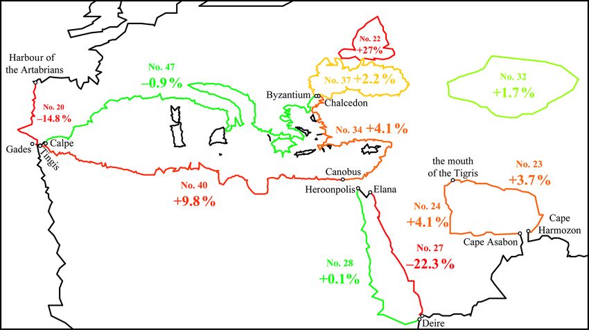
D. A. Shcheglov: The length of coastlines in Ptolemy’s Geography and in ancient periploi                                                 15

Figure 2. Differences between the coastline lengths as derived from Ptolemy’s coordinates and as given by Artemidorus (including those that
he has inherited from Timosthenes and Eratosthenes: nos. 20, 22–24, 27–28, 32, 40, 46–47 in Table 1). The percentages refer to the deviation
of Ptolemy’s values from those of Artemidorus. The outlines are drawn according to the 4 recension supplemented with coordinates from
for the areas of Asia that are missing in 4.

Figure 3. Differences between the coastline lengths as derived from Ptolemy’s coordinates and as given by other periploi-based sources
(nos. 2, 5–6, 8, 12, 16–19, 21, 25, 28, 33, 39, 43–44 in Table 1). The percentages refer to the deviation of Ptolemy’s values from those of
other sources. The outlines are drawn according to the 4 recension supplemented with coordinates from  for the areas of Asia that are
missing in 4.

omni varietate prodentium sumatur computatio), which im-                sion, has usually a more detailed and, therefore, even longer
plies that he knew even larger estimates.                               coastline than 4 (Fig. 1).
   Remarkably, Table 1 shows that the distances in 4 are usu-
ally shorter than in , but longer than in the other sources.           5   The influence of Ptolemy’s erroneous estimate of
This ratio can easily be explained by the so-called coast-                  the circumference of the Earth
line paradox: the well-known fact that a coastline length
varies depending on the level of detail of its geometry. The            Distance data derived from periploi were bound to come into
periploi described, of course, the coastal routes. However,             conflict with other Ptolemy sources, and particularly with his
these routes did not have to replicate all the minor, but numer-        latitude data. In this case, contradictions must have been es-
ous curves and bends of the coast. It is unsurprising, there-           pecially prominent because Ptolemy adopted an erroneous
fore, that the coastline in Ptolemy’s Geography, when mea-              value for the Earth’s circumference, namely 180 000 stades,
sured with all its curves, proves to be a little longer than the        which was about 17 % less than the actual value, if he used
distances recorded in periploi, and , as the second recen-             the stade of 185 m length (Shcheglov, 2016b). Owing to this

www.hist-geo-space-sci.net/9/9/2018/                                                              Hist. Geo Space Sci., 9, 9–24, 2018
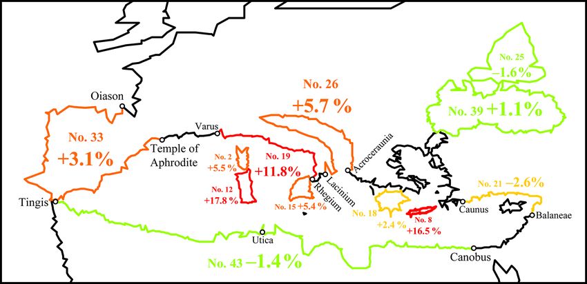
16                                  D. A. Shcheglov: The length of coastlines in Ptolemy’s Geography and in ancient periploi

Figure 4. Deviation of Ptolemy’s coastline length values from those given in the periploi-based sources for the distances over 10 000 stades
(as expressed in the percentage terms). Ptolemy’s data are mostly taken from 4 and in a few cases from  (nos. 23–24, 27, 32, 44–45).
Nos. 31, 49–51 are omitted since they are the sums of the other values.

                                                                           However, I would like to draw attention to another possible
                                                                        and arguably more unusual side-effect of Ptolemy’s underes-
                                                                        timated circumference of the Earth. This effect is observed
                                                                        when a coastline in Ptolemy’s Geography falls into two dis-
                                                                        tinct parts: one oriented north–south, the other east–west. In
                                                                        a number of such cases the same pattern is seen: while the
                                                                        north–south part is shorter than the recorded periploi dis-
                                                                        tance, which is understandable, the east–west part is propor-
                                                                        tionally longer, which requires explanation. It is reasonable
                                                                        to suppose that such a stretching of the east–west parts was
                                                                        intended to compensate for the shortening of the north–south
                                                                        part in order to maintain the total coastline length unchanged.
                                                                        If this explanation is valid, it can give us an important key to
                                                                        understanding Ptolemy’s modus operandi.
                                                                           The effect of proportional shortening/stretching of the
                                                                        neighbouring segments of the coast can be illustrated most
Figure 5. Differences between the coastline lengths in 4 and in
                                                                        clearly by three examples: Italy, the Caspian Sea, and the Red
as expressed in terms of percentage of the 4 values (for the same
                                                                        Sea. In the case of Italy, the southern part of the peninsula is
coastal stretches as shown on Fig. 2).
                                                                        squeezed between the latitudes of the Strait of Messina (at
                                                                        Rhegium) and Naples, whereas the part between Naples and
                                                                        Ostia is proportionally stretched from east to west (Fig. 7).
error, all north–south distances which were tied to particu-            The Caspian Sea is probably compressed from north to south
lar latitudes must also have been reduced by approximately              together with the circumference of the Earth, but proportion-
the same amount. This effect may be illustrated by the exam-            ally stretched from east to west (Figs. 2 and 3). In the case of
ple of the Red Sea coast of the Arabian Peninsula (no. 27 in            the Red Sea, the largest part of its African coast is oriented
Table 1). In Ptolemy’s Geography, this coast is squeezed be-            from north to south and squeezed between the latitudes of
tween the latitude of its northern extremity (Elana, 29◦ 150 )          its northern extremity and of Ptolemais Theron in the south,
and that of Ocelis (12◦ ) near the Strait of Deire (Bab-el-             whereas its southern part, turning eastward to the Bab-el-
Mandeb), the latter being based on astronomical observa-                Mandeb Strait, is proportionally stretched (Fig. 3). Below I
tions (Ptol. Geogr. 1.7.4). It is unsurprising, therefore, that         consider these instances in detail.
this coast exhibits a 22 % reduction in length.

Hist. Geo Space Sci., 9, 9–24, 2018                                                             www.hist-geo-space-sci.net/9/9/2018/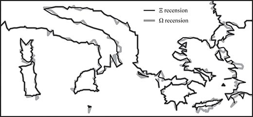
D. A. Shcheglov: The length of coastlines in Ptolemy’s Geography and in ancient periploi                                                  17

Figure 6. Differences between the coastline lengths in 4 and in  as expressed in terms of percentage of the 4 values (for the same coastal
stretches as shown on Fig. 3).

Figure 7. Pliny’s points of the coast of Italy on Ptolemy’s map (4
recension). The percentages refer to the deviation of Ptolemy’s val-
ues for the coastline length from those given by Pliny (no. 29 in
Table 1) and Agrippa (nos. 1 and 9).
                                                                        Figure 8. Pliny’s points of the coast of Italy on the modern map.

5.1   Italy
                                                                        is distinctly stretched in the east–west direction relative to
Only a few ancient sources provide detailed information on              Pliny’s distances, whereas southern Italy is almost equally
individual distances along the coast. Pliny’s description of            compressed. For example, Ptolemy’s coast from Circei to
Italy is among them (Natural History 3.49, 51, 56, 62, 70,              Surrentum is stretched by 78 m.p., whereas that from Saler-
73, 95, 97, 99, 100, 111, 115, 127). Table 2 shows how                  num to Rhegium is shortened by 83 m.p. Similar compres-
Pliny’s values for the separate coastal stretches constituting          sions and stretchings of these coastal sections are exhib-
the perimeter of Italy relate to Ptolemy’s data (see also Figs. 3       ited by Ptolemy’s map relative to the modern map (Table 2,
and 7).                                                                 Fig. 8).
   Ptolemy’s Italy may be divided into three parts (Fig. 7):               The compression of southern Italy in the north–south di-
(1) the northern part lying west of Ostia and Ancona, (2) the           rection can be easily explained, first of all, by Ptolemy’s un-
middle part lying east of Ostia and Ancona and north of                 derestimated value for the Earth’s circumference. Ptolemy’s
Naples, and (3) the part lying to the south of Naples. Ta-              latitudes for southern Italy are rather accurate: for example,
ble 2 shows that for northern Italy Ptolemy’s distances ac-             the interval between his latitudes of Surrentum and Rhegium
cord tolerably with Pliny’s figures.17 Ptolemy’s middle Italy
                                                                        average as compared to Pliny’s figures, which is quite a lot, but it
  17 Ptolemy’s coast from Ravenna to the mouth of the Formio            can still be explained by the fact that Ptolemy’s data almost always
matches Pliny’s distances pretty well. The length of the coast from     exhibit a similar overestimation of distances relative to the periploi
the Varus to Cape Circei is exaggerated by 8 % (or 42.5 m.p.) on        data (Table 1).

www.hist-geo-space-sci.net/9/9/2018/                                                              Hist. Geo Space Sci., 9, 9–24, 2018
18 D. A. Shcheglov: The length of coastlines in Ptolemy’s Geography and in ancient periploi
Table 2. Comparison of the distances along the coast of Italy according to Pliny, Ptolemy, and measurements using Google Maps (Google
Inc., 2017). All distances are expressed in terms of Roman miles; 1 m.p. = 1480 m.
Stretches of the coast Pliny Ptolemy Difference between Google
from – to (P) Pliny and 4 Maps∗
4 m.p. %
(4–P ) (4–P ) / P × 100
Varus–Macra 211 219.1 214.8 8.1 3.8 % 154–182
Macra–Tiber (Ostia) 284 315.1 350.4 31.1 11 % 215–240
Tiber (Ostia)–Cape Circei 50 53.2 53.2 3.2 6.5 % 58–61
Circei–Surrentum 78 155.6 224.2 77.6 99.5 % 87
Surrentum–Salernum 30 26.5 22.3 −3.5 −11.5 % 36–37
Salernum–Rhegium 237 153.7 167.8 −83.3 −35.1 % 200–236
Rhegium–Locri 66 73 71.7 7 10.7 % 100
Locri–Cape Lacinium 86 or 75 67.4 71.7 −18.6 or −7.6 −21.6 % or −10.1 % 83–95
Tarentum (Taras)–Iapygia 108 88 78.9 −20 −18.5 % 90–100
Iapygia–Garganum Mt 234 177.3 189.9 −56.7 −24.3 % 215–233
Garganum–Ancona 183 335.4 379.6 152.4 83.3 % 200–225
Ancona–Ravenna 105 88.3 88.6 −16.7 −15.9 % 90
Ravenna–Formio 189 183.9 187.9 −5 −2.7 % 155–190
∗ The accuracy of this comparison should not be overestimated, because the routes on Google Maps have been measured rather arbitrarily. The lower
and upper values in the table refer to the shortest route across the open sea and the route along the coast, respectively.
is 2◦ 250 , which is pretty close to the true value of 2◦ 300 . mouth of the Varus to Rhegium deviate from Pliny’s val-
However, for Ptolemy the corresponding distance amounts ues by only 2.4 % (no. 29 in Table 1) and 3.7 % (no. 19).
to 150 m.p., whereas the correct value would have been Hence, it is tempting to explain this by assuming that the
188 m.p. magnitude and direction of the disagreements may have been
Ptolemy’s southern Italy is distinctly squeezed between selected intentionally so that stretchings and compressions
the latitudes of Naples (40◦ 550 in 4; the true latitude is would have cancelled each other out.
40◦ 500 ) in the north and that of the Strait of Messina (in par-
ticular Cape Pelorus, 38◦ 350 in ; the true latitude is 38◦ 160 ) 5.2 The Caspian Sea
in the south. These latitudes corresponded to the so-called
klimata with the longest day of 15 and 14 3/4 h, respectively. The coincidence between Ptolemy’s and Artemidorus’ val-
Klimata (sing. klima) was a technical term for latitudes de- ues for the perimeter of the Caspian Sea gives us a key to
fined by the length of the longest day. These klimata were, in explaining its strange configuration in Ptolemy’s Geography,
essence, the principal tool available to pre-Ptolemaic geogra- namely why it is shown as being longer from east to west (ca.
phers for constructing a mathematically rigorous map of the 8250 stades from Gangara to the mouth of the Polytimetos)
world, at least, from Eratosthenes onwards.18 A set of these than from north to south (ca. 4400 stades between the mouths
klimata constituted the basis of the geographical system of of the Rha and the Straton; see Fig. 3).
Marinus of Tyre, Ptolemy’s immediate predecessor and the First of all, it is tempting to connect this anomaly with
principal source (Honigmann, 1930; Wurm, 1931). There- the fact that the whole of Ptolemy’s map exhibits a similar
fore, Ptolemy’s latitudes of Naples and Pelorus go back, most stretching of all its outlines from east to west relative to the
probably, to Marinus or even further. modern map.20 This stretching can largely be explained by
It is striking that various divergences between Ptolemy’s Ptolemy’s underestimated value for the Earth’s circumfer-
and Pliny’s data on the separate coastal stretches (Table 2)19 ence. This effect is due to the principal difference between
are in stark contrast with the close agreement between their the methods of measuring latitude and longitude (Shche-
values for the total length of the coast: Ptolemy’s figures for glov, 2016b; Graßhoff et al., 2016). Latitude can be deter-
the perimeter of Italy and for the southern side from the mined by means of simple astronomical observations, which
had been known to the Greeks since at least the 4th century
18 On the system of klimata, see Honigmann (1929), Neuge- BC, and starting at least with Hipparchus (2nd century BC)
bauer (1975, p. 43–45, 333–336, 725–733), Shcheglov (2004); on it was normally expressed in degrees. But it was not until
klimata as a basis of Ptolemy’s map, see Wurm (1931, p. 20–21, the 18th century that an efficient and simple enough method
30), Isaksen (2013, p. 50, Fig. 3.4).
19 Similar observations have been made by Mittenhuber (2012) 20 On the variation in this error for different parts of Ptolemy’s
for Ptolemy’s Hispania. map, see Shcheglov (2016b).
Hist. Geo Space Sci., 9, 9–24, 2018 www.hist-geo-space-sci.net/9/9/2018/D. A. Shcheglov: The length of coastlines in Ptolemy’s Geography and in ancient periploi 19
of determining longitude was devised. For an ancient geog- It is also remarkable that, on Ptolemy’s map, the north-
rapher, the main method to find longitude was to convert ern extremities of the Caspian Sea, as well as the northern
distance measurements from customary linear units (Greek coast of the Pontus Euxinus, are clearly tied to the latitude
stades, Roman miles, etc.) to angular units (degrees), for of the mouth of the Borysthenes (48 1/2◦ ), one of the seven
which the estimate of the Earth’s circumference was essen- klimata or the key latitudes determining the structure of his
tial. This is why an error in this estimate inevitably affected map and going back, most probably, as far as Eratosthenes
all longitude values based on distance measurements, but had (Fig. 3).21 These correspondences make it possible to sup-
no effect on latitude values when they had been originally ex- pose that Ptolemy’s meridional extension of the Caspian Sea
pressed in degrees. A too low value for the circumference of had been originally defined as slightly more than 6000 stades
the Earth results in that all distances projected on its surface and that this distance was expressed in degrees of latitude al-
(i.e. converted to degrees) become proportionally overesti- ready in the early version of the map, which was based on
mated in angular terms, which made the outlines on the map Eratosthenes’ value for the Earth’s circumference.
stretch mostly in the east–west direction (e.g. Russo, 2013; Interestingly, 6183 stades is quite close to the quotient of
Shcheglov, 2016a, b). However, Ptolemy’s underestimation 20 000 stades (the perimeter of the Caspian Sea according to
of the size of the Earth could have been responsible for a Artemidorus; no. 32 in Table 1) divided by π . If this coinci-
stretching by only 17 %, which is evidently insufficient to dence is not accidental, and if the circumference of 20 000
explain the configuration of the Caspian Sea in his Geogra- stades and the meridional extension of slightly more than
phy. 6000 stades were the two parameters that determined the
Furthermore, Ptolemy’s Caspian Sea is not only stretched outlines of the Caspian Sea from the very beginning, then it
from east to west but also compressed from north to south. mathematically implies that in the early “Eratosthenic” ver-
The only ancient estimate of the north–south extension of sion of Ptolemy’s map the sea must have had a round shape.
the Caspian Sea comes from Strabo (2.1.17 C74): he defines We may suppose that, when Ptolemy had accepted a smaller
the meridional distance between its southernmost end and the value for the Earth’s circumference instead of Eratosthenes’
mouth entering the Ocean in the north as “about” (περὶ) 6000 252 000 stades, the meridional extension of the Caspian Sea,
stades. This value matches the actual straight-line length of being expressed in degrees, remained unchanged, whereas
the Caspian Sea pretty well (provided that 1 stade = 185 m). its circumference was recalculated to the 500-stade degrees,
However, Ptolemy’s latitude interval between the northern which made the sea stretch from east to west and take the
(the mouth of the Rha at 48◦ 500 ) and the southern (the mouth shape it has on Ptolemy’s map today.
of the Straton at 40◦ ) extremities of the Caspian Sea corre- There is a difficulty, however, in that other ancient sources
sponds to only 4417 stades (Fig. 3; of course, there is no rea- never compare the Caspian Sea with a circle.22 On the con-
son to suppose that any of Ptolemy’s latitudes for the Caspian trary, they often use quite different comparisons: a sickle or
Sea could have been based on actual astronomical observa- the horns of the crescent, or a mushroom cap.23 But this
tions). choice of metaphors might be due to the fact that, unlike
The situation is complicated by the fact that there may Ptolemy, other sources considered the Caspian Sea as a gulf
have existed a hypothetical early version of Ptolemy’s Geog- of the Ocean. Anyway, a circle seems to be the simplest and
raphy that was based on a different estimate for the Earth’s the most obvious figure that comes to mind to describe the
circumference, namely 252 000 stades, which was ca. 16.5 % shape of an unexplored sea or gulf about which almost noth-
above the true value (252 000×185 m = 46 620 km). This es- ing was known.24
timate was first proposed by Eratosthenes and can be re-
garded as almost generally accepted in antiquity. As has been 21 On Eratosthenes as a source of Ptolemy’s seven klimata, see
shown by Schnabel (1930, p. 218–219), Ptolemy probably Honigmann (1929) and Shcheglov (2004).
used this value for calculating geographic longitudes in the 22 In contrast to, for example, the Persian Gulf which was de-
Almagest, one of his early works. Even more importantly, scribed as “round” and “similar to a human head”, see Agathem.
Sarre and Herzfeld (1911, p. 143–153), Wurm (1937, 1940), 3.12: κυκλοτερής; Mela, Chorogr., 3.71: reddit formam capitis hu-
and Shcheglov (2004, 2017) have shown, independently of mani; Plin. 6.108: humani capitis effigie.
23 Agathem. 3.13: μηνοειδής (crescent-shaped); Curt. Ruf. 6.4.16:
one another, that a large area on Ptolemy’s map was built on
the basis of Eratosthenes’ set of distances which were con- . . . lunae maxime similem, quum eminent cornua, quum eminent
cornua, nondum totum orbem sidere implente; Plin. 6.38: . . . lunatis
verted to spherical coordinates according to Eratosthenes’
obliquatur cornibus . . . sicilis, ut auctor est M. Varro, similitudine;
rate of 1◦ = 700 stades. This area covers the whole of the
Iordan. Getica 5.30: ab Oceano euroboro in modum fungi, pri-
Middle East, at least, between the Euphrates and the In- mum tenui, posthaec latissima et rotunda forma exoritur; the same
dus including the Caspian Sea. More importantly, Ptolemy’s crescent-like shape of the Caspian Sea is seen on the so-called Tab-
breadth of the Caspian Sea, when expressed in Eratosthenes’ ula Peutingeriana, see http://www.cambridge.org/us/talbert/mapb/
700-stade degrees, corresponds to 6183 stades which closely TP2000seg11.jpg or http://peutinger.atlantides.org/map-a.
agrees with Strabo’s distance, as was noted by Wurm (1937, 24 Remarkably, there are two other seas that have regular rounded
p. 7, 13, 1940, p. 8, 11). shapes in Ptolemy’s Geography: the Bay of Ganges (modern Bay
www.hist-geo-space-sci.net/9/9/2018/ Hist. Geo Space Sci., 9, 9–24, 201820 D. A. Shcheglov: The length of coastlines in Ptolemy’s Geography and in ancient periploi
Table 3. Length of the Red Sea coast according to Artemidorus, Eratosthenes, Ptolemy, and measurements using Google Maps (Google Inc.,
2017). All distances are expressed in stades; 1 stade = 185 m.
Stretches of the coast Distance Difference between Difference between
(stades) 4 and Artemidorus 4 and Google Maps
Eratosthenes and Ptolemy Google stades % stades %
Artemidorus (D) Maps (GM)
4 (4–D) (4–D)/ (4–GM) (4–GM)/
D × 100 GM × 100
Heroonpolis–Ptolemais 9000 7575 7864 8108–8189 −1,425 −15.8 −533–614 −6.5–7.6
Heroonpolis–Berenice 4180 3266 3366 4324 −914 −21.9 −1058 −24.5
Berenice–Ptolemais 4820 4310 4497 3784–3865 −510 −10.6 445–526 11.5–13.9
Ptolemais–Deire 6500 7944 8211 4700–4843 1444 22.2 2766–2909 57.1–61.9
5.3 The Red Sea map relative to the modern map (Table 3).27 As in the case
of Italy, the compression of the north–south coastal segment
The general configuration of the Red Sea (or, in ancient can be accounted for by Ptolemy’s erroneous estimate of the
terms, the Arabian Gulf) on Ptolemy’s map is determined circumference of the Earth, but the stretching of the segment
by the latitudes of four points: Berenice, Ptolemais Theron, Ptolemais–Deire by exactly the same amount seems suspi-
Adulis, and Ocelis (Fig. 3).25 The length of the African coast cious and requires some additional explanation.
from Heroonpolis (the northernmost point) to Deire (situated
opposite to Ocelis) in Ptolemy’s work is exactly the same as
in Artemidorus (in 4 it is only 0.1 % or 19 stades shorter, in 6 Conclusions and further perspectives
it is 3.7 % or 574 stades longer; see Table 1). However, the
lengths of the separate coastal stretches recorded by Eratos- The main conclusion of our study is intuitively expectable
thenes and Artemidorus relate to Ptolemy’s data as follows. and in this sense unsurprising, namely that Ptolemy’s Geog-
Table 3 shows that the north–south stretch from Heroonpo- raphy was most likely based on some ancient periploi sim-
lis to Ptolemais is ca. 1425 stades shorter in Ptolemy than ac- ilar to those known from other sources. What seems unex-
cording to Artemidorus, while the next one turning to the east pected and much more important is that our study has re-
from Ptolemais to Deire is ca. 1444 stades longer.26 Similar vealed a close numerical agreement between Ptolemy’s Ge-
deformations of these stretches are exhibited by Ptolemy’s ography and the other periploi-based sources in the data on
the length of relatively long coastlines (over 10 000 stades):
of Bengal) and the Great Bay (the Tongking Gulf); see e.g. Stück- in most cases the differences between Ptolemy’s data and the
elberger and Graßhoff (2006, p. 896–897, 902–903). other sources fall between +4 and −1 %. This observation
25 In Ptolemy’s Geography, Berenice is situated at the latitude of can provide a new insight into the genesis of Ptolemy’s Ge-
Syene (23◦ 500 ), Ptolemais at the latitude of Meroe (16◦ 300 in 4 ography and the history of ancient geography in general.
and in Canon of the noteworthy cities 14.2 or 16◦ 250 in ), which A major challenge we face now is how to reconcile this
correspond to the klimata with the longest day of 13 1/2 and 13 h, striking agreement between Ptolemy’s data and the other
respectively. Such arrangement of these points goes back as far as sources with the equally striking contradictions between
Eratosthenes (F IIB37–38, IIIA18 Berger = F 41–42, 59 Roller) or,
them in the short coastal stretches of which the long ones
at least, Hipparchus (F V4–V5 Berger = F 46–47 Dicks = Strab.
2.5.36 C133). Adulis (Almagest 2.6.4 Heiberg p. 105–106) and
consist (as was demonstrated by the example of Italy). In
Ocelis (Geogr. 8.22.7) were presumably connected with the klima other words, with increase in the coastline lengths being
of the 12 3/4 h day (12◦ 300 ) in the early version of Ptolemy’s map compared, different discrepancies between Ptolemy and the
(see Wurm, 1931, 23–24), but in the final version they have been other sources compensate one another until an almost com-
shifted to the latitudes of 11◦ 400 (4 and Canon of the noteworthy plete agreement is reached. But what factors determined this
cities 14.2) or 11◦ 200 () and 12◦ , respectively. Modern latitudes transformation? Could it be intentional, or just accidental,
of these points (according to the database of http://pleiades.stoa.org) and to what extent? This question compels us to revisit our
are as follows: Berenice: 23◦ 550 , Ptolemais: 18◦ 130 , Adulis: 15◦ 130 , understanding of Ptolemy’s methods and the relevancy of
Ocelis: 12◦ 430 , Deire: 12◦ 260 . our methods of examining his work. For the time being, we
26 Artemidorus gave 9000 stades for the distance from Heroon-
polis to Ptolemais, and thence 6500 to Deire (Agathem. 3.14). (F IIB37–38 Berger = F 41–42 Roller = Plin. 2.183; 6.171), and,
However, according to Pliny (6.164), Artemidorus’ values for the accordingly, 4180 from Heroonpolis to Berenice.
first distance was 9500. Eratosthenes gave also 9000 stades from 27 However, a part of this deformation is due to the fact that
Heroonpolis to Ptolemais, thence 4500 to Deire (F IIIB48 Berger = Ptolemy and his predecessors placed Ptolemais 2◦ too far to the
F 95 Roller = Strab. 16.4.4 C768), 4820 from Berenice to Ptolemais north of Marsa Aqiq, its modern counterpart.
Hist. Geo Space Sci., 9, 9–24, 2018 www.hist-geo-space-sci.net/9/9/2018/You can also read