Bird strandings and bright lights at coastal and offshore industrial sites in Atlantic Canada
←
→
Page content transcription
If your browser does not render page correctly, please read the page content below
VOLUME 16, ISSUE 1, ARTICLE 22
Gjerdrum, C., R. A. Ronconi, K. L. Turner, and T. E. Hamer. 2021. Bird strandings and bright lights at coastal and offshore industrial sites in
Atlantic Canada. Avian Conservation and Ecology 16(1):22. https://doi.org/10.5751/ACE-01860-160122
Copyright © 2021 by the author(s). Published here under license by the Resilience Alliance.

Research Paper

Bird strandings and bright lights at coastal and offshore industrial sites
in Atlantic Canada
Carina Gjerdrum 1, Robert A. Ronconi 1, Kelley L. Turner 2,3 and Thomas E. Hamer 2
1
  Canadian Wildlife Service, Environment and Climate Change Canada, 2Hamer Environmental, 3Lummi Nation Natural Resources
Department

ABSTRACT. Artificial lights can disorient birds and lead to injury or death. In Atlantic Canada, lights attract birds at sites along the
coastline and offshore, but the relative impacts of lights on birds in this region are largely unknown. We summarized data on stranded
bird encounters submitted annually to the Canadian Wildlife Service, Environment and Climate Change Canada, and quantified light
radiance values at a selection of industrial sites in the region. Stranded birds were reported from offshore oil and gas production
platforms, support vessels, and seismic ships, and from onshore oil and gas refineries and construction facilities. Leach's Storm-Petrel
(Hydrobates leucorhoa) was the most abundant bird species to be stranded: most were found alive offshore Newfoundland and Labrador,
and were subsequently released. Landbirds dominated the stranded bird reports from Nova Scotia. Offshore platforms in Newfoundland
and Labrador were brighter than onshore sites, and were brighter than platforms located in Nova Scotia, particularly during the Leach's
Storm-Petrel breeding season, in part due to flaring activity. Stranding events were more likely during nights with little or no moonlight,
but systematic searches for stranded birds, with documentation of search effort by trained personnel, are needed to better understand
how light characteristics, weather, and the location of sites influence strandings, and to monitor the effectiveness of light mitigation.
Minimizing the threat of light attraction for declining populations of Leach's Storm-Petrels in the Atlantic is of particular importance
given the species’ current conservation status.

Échouement d'oiseaux et lumières artificielles sur des sites industriels côtiers et en mer dans le Canada
atlantique
RÉSUMÉ. Les lumières artificielles peuvent désorienter les oiseaux et leur causer des blessures ou la mort. Au Canada atlantique, les
lumières attirent les oiseaux à des sites répartis le long du littoral et en mer, mais les impacts relatifs des lumières sur les oiseaux dans
cette région sont largement inconnus. Nous avons compilé les données sur les oiseaux échoués trouvés et soumis annuellement au
Service canadien de la faune, Environnement et Changement climatique Canada, et quantifié les valeurs de radiance lumineuse sur une
sélection de sites industriels de la région. Les oiseaux échoués ont été signalés à partir de plateformes de production de pétrole et de
gaz en mer, de navires de soutien et de navires sismiques, ainsi qu'à des raffineries de pétrole et de gaz et des installations de construction
continentales. L'Océanite cul-blanc (Hydrobates leucorhoa) est l'espèce d'oiseau à s'être le plus échouée : la plupart ont été retrouvés
vivants au large de Terre-Neuve-et-Labrador et ont ensuite été relâchés. Les oiseaux terrestres figuraient en tête des rapports d'oiseaux
échoués en Nouvelle-Écosse. Les plateformes en mer de Terre-Neuve-et-Labrador étaient plus lumineuses que les sites terrestres et
étaient plus lumineuses que les plateformes situées en Nouvelle-Écosse, surtout pendant la saison de reproduction de l'Océanite cul-
blanc, en partie à cause de l'activité de brûlage à la torche. L'échouement d'oiseaux était plus probable pendant les nuits avec peu ou
pas de clair de lune, mais des recherches systématiques d'oiseaux échoués, documentant l'effort de recherche par du personnel qualifié,
sont nécessaires pour mieux comprendre comment les caractéristiques de la lumière, les conditions météorologiques et l'emplacement
des sites influent sur l'échouement, et pour surveiller l'efficacité des mesures d'atténuation de la lumière. La réduction de la menace de
l'attraction lumineuse pour les populations d'Océanites cul-blanc en diminution dans le Canada atlantique est particulièrement
importante étant donné le statut de conservation actuel de l'espèce.
Key Words: Atlantic Canada; groundings; Leach's Storm-Petrel; light attraction; marine birds; radiance; stranded birds

INTRODUCTION                                                                 made structures or the ground (Ainley et al. 2001), or succumb
The use of artificial light at night is a significant source of              to predators, starvation, or dehydration when forced to land
anthropogenic pollution with ecological impacts (Rich and                    (Rodríguez et al. 2012, 2014).
Longcore 2006, Hölker et al. 2010, Davies et al. 2014, Manfrin et            In Atlantic Canada, significant light pollution is observed from
al. 2017). Marine birds often encounter artificial light from                large urban centers such as the coastal cities of Halifax, Nova
coastal sources, such as streetlights and lighthouses, which can             Scotia (NS) and St. John’s, Newfoundland and Labrador (NL),
attract and disorient birds during transits between colony and               but also from less populated municipalities and coastal industrial
foraging sites (Montevecchi 2006, Troy et al. 2013, Rodríguez et             sites (Falchi et al. 2016), some of which are adjacent to seabird
al. 2017b). As a result, birds may die from collisions with human-

Address of Correspondent: Carina Gjerdrum, 45 Alderney Drive, 16th Floor, Dartmouth, NS , Canada, B2Y 2N6, carina.gjerdrum@canada.ca
Avian Conservation and Ecology 16(1): 22
                                                                                                        http://www.ace-eco.org/vol16/iss1/art22/

colonies (Wilhelm et al. 2013). Beyond the shoreline, offshore oil        annually to CWS-ECCC between 1998 and 2018. The remaining
and gas production platforms use artificial lights to illuminate          reports (n = 116) indicated that no stranded birds were found.
working and living areas, and some installations regularly flare          The data associated with each report included date, location,
excess gas, which produces both light and heat, with the added            species, condition (live or dead), and fate of the bird (released,
mortality risk to birds that fly near or into the flare (Day et al.       sent ashore, died in care, disposed of at sea). If oil was detected
2015, Ronconi et al. 2015). Fishing vessels, container ships, oil         on the bird, this too was reported. During this period, scientific
and gas industry support vessels, and cruise ships also contribute        permits were also issued to a rescue organization authorized to
light to the offshore environment in areas where birds may                capture and release Atlantic Puffins (Fratercula arctica), and more
encounter them (Merkel and Johansen 2011, Krüger et al. 2017).            recently, Leach’s Strom-Petrels, along the east coast of the Avalon
                                                                          Peninsula, NL. However, for this study, we did not include these
Seabird fledglings are particularly vulnerable during their first         data because they are published elsewhere (Wilhelm et al. 2013,
flight from the nest to the ocean (Wilhelm et al. 2013, Rodríguez         2021).
et al. 2017b, 2017c), perhaps due to their inexperience and an
undeveloped visual system from lack of exposure to light during           Study sites and sampling period for light
their development in underground burrows (Atchoi et al. 2020).            radiance
In addition, bird attraction to light increases when visibility is        We quantified artificial light emittance at 16 sites across Atlantic
poor due to rain or fog (Russell 2005, Montevecchi 2006), and             Canada (Table 1, Fig. 1): six in NL and 10 in NS. Sites included
when lunar illumination is low (Rodríguez and Rodríguez 2009,             nine offshore oil or gas production facilities and three coastal
Miles et al. 2010). Seabirds can also aggregate around offshore           onshore industrial sites where strandings had previously occurred
oil drilling and production platforms due to olfactory and visual         (Baillie et al. 2005, Ellis et al. 2013); two coastal city sites to
cues (Hope-Jones 1980, Wiese et al. 2001). In Atlantic Canada,            represent the brightest sites in the region; and the center of two
nocturnal migratory landbirds, petrel species (Procellariiformes),        core foraging areas of the Leach’s Storm-Petrel as determined by
and alcids (Alcidae) appear to be taxa most at risk to light              telemetry studies from the nesting colonies on Gull Island, NL
attraction (Wiese et al. 2001, Ellis et al. 2013, Ronconi et al. 2015),   and Country Island, NS (Hedd et al. 2018). Offshore sites in NL
but the relative impacts are largely unknown due to a lack of             included a gravity base structure (GBS) and two floating,
systematic monitoring and incomplete documentation of dead                production, storage, and offloading (FPSO) vessels used for oil
and stranded (i.e., grounded) birds. As a result, population-level        extraction (all with flare systems for excess gas); in NS, offshore
impacts remain unknown, and effective mitigation methods are              sites included two gas production platforms with flare systems,
untested. This information is of particular importance for the            three satellite gas production platforms that were unstaffed with
Leach’s Storm-Petrel (Hydrobates leucorhoa), the species most             no flaring, and an exploratory drillship with a flare system (Table
often found stranded on offshore platforms and vessels in the             1). The drillship was operating offshore NS for a portion of the
Atlantic (Baillie et al. 2005, Ellis et al. 2013, Ronconi et al. 2015,    study period, from June through September 2016. Although the
Davis et al. 2017) and a species that is in significant decline           NS gas production platforms were active during the study period,
(Wilhelm et al. 2019).                                                    they have since been decommissioned and facilities were removed
We summarize existing data on stranded bird encounters                    in 2020. The three onshore facilities used in the study all had flare
submitted annually to the Canadian Wildlife Service,                      systems (Table 1). The two foraging areas were included to
Environment and Climate Change Canada (CWS-ECCC) as a                     represent dark sites against which industrial and city sites could
requirement of permits for the capture and handling of migratory          be compared.
birds. In addition, we compare light radiance values at a selection       We standardized the area sampled for artificial light values at each
of coastal and offshore industrial sites in Atlantic Canada to those      site using a 15 km radius polygon, which was the size needed to
at natural foraging locations of the Leach’s Storm-Petrel to better       encompass the area of the largest light radiance footprint
understand exposure, and hence risk, to artificial night lighting         measured at the offshore sites. We evaluated light radiance at each
in this region.                                                           site monthly between April 2016 and March 2017. This period
                                                                          included one continuous Leach’s Storm-Petrel breeding season
METHODS                                                                   (April 2016–October 2016) and one non-breeding season
                                                                          (November 2016–March 2017).
Bird stranding data
The Canadian Wildlife Service, Environment and Climate                    Light radiance analyses
Change Canada in Atlantic Canada issues scientific permits for            To evaluate light radiance at each study site, we used average
the capture and handling of migratory birds at coastal and                radiance composite imagery using nighttime data from the Visible
offshore industrial sites where bird strandings may occur. The            Infrared Imaging Radiometer Suite (VIIRS) Day/Night Band
permit holder is authorized to collect dead migratory birds and           (DNB) produced by the Earth Observation Group, NOAA
capture, transfer, or release live migratory birds that are               National Geophysical Data Center (Elvidge et al. 2017). Prior to
encountered on the site. Instructions for handling and                    averaging, the DNB data were filtered to exclude data affected by
documenting stranded birds are provided to the permit holder              lightning, lunar illumination, and cloud cover. Light from fires,
(Williams and Chardine 1999, Environment and Climate Change               northern lights (aurora borealis), boats, and other temporal lights
Canada 2017), and reporting of all stranded birds is required as          were not filtered out. During the summer months, solar
part of the conditions of the permit. For this study, we obtained         illumination near the poles made it difficult to filter stray light
stranded bird data from 110 of the 226 permit reports submitted           from artificial light sources. To account for this, radiance values
Avian Conservation and Ecology 16(1): 22
                                                                                                               http://www.ace-eco.org/vol16/iss1/art22/

Table 1. Location and description of 16 study sites in Newfoundland and Labrador (NL) and Nova Scotia (NS) used to quantify light
emittance and radiance values in Atlantic Canada. The general location of sites is shown in Fig. 1.

Site                                 Province     Location             Description
City
 St. John's                          NL           47.56° N, 52.71° W   Capital of Newfoundland and Labrador; population = 108,160 (Statistics
                                                                       Canada 2017a)
 Halifax                             NS           44.65° N, 63.58° W   Capital of Nova Scotia; population = 403,390 (Statistics Canada 2017b)
Onshore
 Come By Chance refinery             NL           47.80° N, 53.99° W   Crude oil refinery (with flare system)
 Point Tupper refinery               NS           45.58° N, 61.34° W   Natural gas refinery (with flare system) and marine terminal for storage and
                                                                       transshipment of crude oil and petroleum products
 Goldboro LNG                        NS           45.18° N, 61.62° W   Gas plant and liquefied natural gas (LNG) processing facility (with flare system)
Offshore
                                                                                                                                         †
 Hibernia GBS                        NL           46.75° N, 48.78° W   Gravity base structure (GBS) for oil production (with flare system ) operating
                                                                       since 1997 in the Hibernia oil field
                                                                                                                                                     †
    Sea Rose FPSO                    NL           46.79° N, 48.02° W   Floating production, storage, and offloading (FPSO) vessel (with flare system )
                                                                       operating since 2005 in the White Rose oil and gas field
                          ‡                                                                                                                          †
    Terra Nova FPSO                  NL           46.48° N, 48.48° W   Floating production, storage, and offloading (FPSO) vessel (with flare system )
                                                                       operating since 2002 in the Terra Nova oil and gas field.
              §
    Thebaud                          NS           43.89° N, 60.20° W   Gas production platform (with flare system) operating since 1999 as part of the
                                                                       Sable Offshore Energy Project
                              §
    Venture/South Venture            NS           44.02° N, 59.60° W   Satellite gas production platform (unstaffed wellhead platform) operating since
                                                                       2000 as part of the Sable Offshore Energy Project. Two platforms ~5.3 km apart,
                                                                       assessed as one site.
                      §
    North Triumph                    NS           43.70° N, 59.85° W   Satellite gas production platform (unstaffed wellhead platform) operating since
                                                                       2000 as part of the Sable Offshore Energy Project
         §
    Alma                             NS           43.60° N, 60.69° W   Satellite gas production platform (unstaffed wellhead platform) operating since
                                                                       2003 as part of the Sable Offshore Energy Project
                  §                                                                                                †
    Deep Panuke                      NS           43.81° N, 60.69° W   Gas production platform (with flare system ) operating since 2013 as part of the
                                                                       Deep Panuke Offshore Gas Development Project
    Stena IceMax                     NS           42.44° N, 62.25° W   Exploratory drillship (with flare system) operating from June to September 2016
                                                                       at this location as part of the Shelburne Basin Venture Exploration Drilling
                                                                       Project
                                      †
Core Leach's Storm-Petrel foraging area
 Gull Island population               NL          45.65° N, 47.13° W   Breeding population estimate 180,000 pairs (Hedd et al. 2018) at Gull Island,
                                                                       Witless Bay (47.24° N, 52.78° W)
    Country Island population        NS           42.68° N, 56.06° W   Breeding population estimate 12,000 pairs (Hedd et al. 2018) at Country Island
                                                                       (45.10° N, 61.54° W)
†
 Monthly data on flare emissions are available.
‡
 Facility moved inshore for upgrade in 2020.
§
 Facilities decommissioned and removed in 2020.

underwent a stray light correction procedure (Mills et al. 2013),             foraging areas, which were far from any light sources (minimum
although residual background noise may remain (radiance values                distance between the center of the foraging location and the
< 1 nW·cm-2·sr-1).                                                            industrial site = 139.6 km) (Fig. 1). These foraging areas had a
                                                                              maximum radiance range of 0.04–0.71 nW·cm-2·sr-1 over the year.
Average radiance composite imagery was produced for each site
                                                                              Therefore, a light radiance cutoff value of 0.75 nW·cm-2·sr-1 was
for each month of the study period. Each pixel (317 x 317 m) in
                                                                              selected. Values less than 0.75 nW·cm-2·sr-1 were therefore
the monthly imagery represents the average radiance value of all
                                                                              considered dark or areas with no light. In ArcGIS, the Con tool
measurements made during the month and is reported as nW·
                                                                              was used to define light and dark pixels within each site, and the
cm-2·sr-1. Monthly average radiance composite imagery was
                                                                              Spatial Analyst Tabulate Area tool was used to quantify the light
imported into ArcGIS for analysis (version 10.7.1; ESRI Inc.
                                                                              emittance area reported as square kilometers (i.e., light footprint).
2019). The project area was more than 1300 km wide and spanned
                                                                              Across sites, we quantified the percentage of the total sampling
four UTM grid zones. To minimize pixel distortion and calculate
                                                                              area covered by pixels with a value greater than 0.75 nW·cm-2·sr-1
accurate light radiance areas, monthly imagery was first projected
                                                                              by month (i.e., percentage of light emittance area) and reported
into one of the four UTM grid zones, as appropriate. Using the
                                                                              in which month the greatest value was recorded (i.e., peak month
Spatial Analyst Zonal Statistics tool, the average radiance value
                                                                              of light emittance).
of each pixel within the 15 km radius study site was summed to
produce the total monthly average radiance for each site (herein              To compare light footprint and radiance values across sites, we
referred to as light radiance).                                               first tested for normality within sites using Shapiro-Wilk’s tests.
                                                                              Approximately half the sites showed non-normal distributions.
To determine the area (km2) of light emittance around each study
                                                                              We used boxplots to identify months with outliers (values above
site and to reduce the stray light background noise, we first defined
                                                                              or below the whiskers of the boxplots) and removed those values
dark pixels using radiance values from Leach’s Storm-Petrel
                                                                              from subsequent analyses (Terra Nova FPSO months 5 and 7;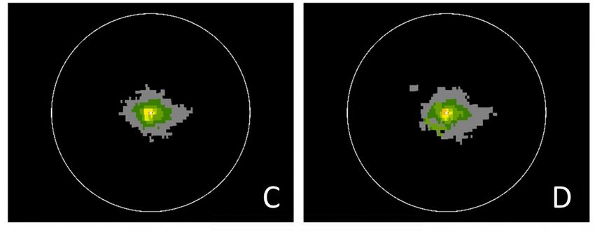
Avian Conservation and Ecology 16(1): 22
                                                                                                      http://www.ace-eco.org/vol16/iss1/art22/

                                                                        were omitted from analyses of light footprint (light footprint was
Fig. 1. Location of Leach’s Storm-Petrel colonies (black circles)       nearly zero at foraging sites).
and study sites: (1) St. John’s, (2) Halifax, (3) Come By Chance
                                                                        Analyses were conducted in R version 4.0.4 (R Core Team 2018).
refinery, (4) Point Tupper refinery, (5) Goldboro LNG, (6)
                                                                        We tested for differences in light footprint and radiance values
Hibernia GBS, (7) Sea Rose FPSO, (8) Terra Nova FPSO, (9)
                                                                        among the three industrial site types (onshore, offshore NL,
Thebaud, (10) Venture/South Venture, (11) North Triumph,
                                                                        offshore NS) using generalized linear mixed models (GLMM) (R
(12) Alma, (13) Deep Panuke, (14) Stena IceMax, (15) Core
                                                                        package “nlme” and “multcomp” for post-hoc comparisons)
Leach’s Storm-Petrel foraging area from Gull Island
                                                                        (Hothorn et al. 2008, Pinheiro et al. 2020), with site as a random
population, and (16) Core Leach’s Storm-Petrel foraging area
                                                                        effect to account for multiple measures (months) at each site.
from Country Island population (see Table 1 for full site
                                                                        Finally, we tested for differences within site types, again using
descriptions). NL = Newfoundland and Labrador; NS = Nova
                                                                        GLMM, but included foraging areas as a control for radiance
Scotia; NB = New Brunswick. The black line depicts the
                                                                        values, which resulted in six models (two light metrics x three
location of the 1000-m contour, which is the approximate
                                                                        industrial site types).
location of the shelf break.
                                                                        Independent from the satellite-derived light data, we also
                                                                        obtained the average monthly flare volumes (m3) at specific
                                                                        platforms from operators or regulating agencies for the 12-month
                                                                        study period. Flaring data were obtained for just four of the nine
                                                                        sites with flaring systems (see Table 1). Monthly flare volume was
                                                                        compared to monthly light radiance and footprint values using
                                                                        GLMM with site as a random effect when pooling data across
                                                                        sites (R package “nlme”), and linear models (R function “glm”)
                                                                        for correlation tests within individual sites (i.e., Deep Panuke, the
                                                                        only site in NS with flaring data). Throughout this paper we report
                                                                        mean ± standard deviation.
                                                                        We were not able to relate stranded bird numbers directly to light
                                                                        radiance values because the bird stranding data were collected
                                                                        opportunistically over 20 years, whereas the radiance data were
                                                                        quantified over a single year, and because radiance data were not
                                                                        quantified at many of the sites where birds were reported to
                                                                        strand. In addition, we could not assess the effect of
                                                                        environmental conditions, such as rain, fog, and wind, on
                                                                        stranded bird numbers because these data were not collected in
                                                                        association with bird stranding events during the study period,
                                                                        and archival weather data are largely non-existent for the offshore
                                                                        (platforms collect these data as part of their daily operations, but
                                                                        they are not archived in a readily available database). Moreover,
                                                                        because stranded birds are discovered opportunistically, the date
                                                                        of detection and reporting of events may not match the date of
                                                                        the stranding event, thus making it difficult to link events with
                                                                        actual weather (e.g., precipitation). However, we examined the
                                                                        relationship between the observed frequency of large stranding
                                                                        events (≥ 10 birds reported stranded in a single day at a particular
                                                                        site; n = 151) and moon phase (very bright = ≥ 80% illumination;
                                                                        bright = 60–79%; medium = 40–59%; low = 20–39%; and very
                                                                        low = < 20%; [https://www.moongiant.com]) using the Chi-square
Deep Panuke month 11; Hibernia GBS month 7). Subsequent                 test, and predicted that light attraction would diminish on nights
Shapiro-Wilk’s tests showed remaining data to be normally               when the moon was relatively bright (Miles et al. 2010).
distributed (or with just minor deviations from normality), with
the exception of city sites, which showed strong deviations from
normality. Further, we tested for homogeneity of variances across
                                                                        RESULTS
sites using Lavene’s test, which showed strong differences owing
to large variances around city and offshore NL sites, compared
                                                                        Bird stranding data
                                                                        Between 1998 and 2018, a total of 7922 stranded birds were
to small variances around foraging areas and offshore NS sites;
                                                                        reported to CWS-ECCC from permitted sites in Atlantic Canada
we found no significant differences among sites within industrial
                                                                        (Table 2). Most of the reported strandings (91.2%) came from
sites types, which was one of the primary analyses (see Results:
                                                                        NL, where the rate of strandings (46.8 stranded birds reported
Light radiance). City sites were omitted from subsequent analysis
                                                                        per permit issued) was higher than the rate reported from NS and
owing to their strong deviation from normality and large
                                                                        New Brunswick (NB) (15.4 stranded birds reported per permit).
variances. Foraging sites were included only as a control for
                                                                        Offshore production platforms and support vessels reported most
analyses of radiance values (i.e., natural light radiance levels) but
Avian Conservation and Ecology 16(1): 22
http://www.ace-eco.org/vol16/iss1/art22/
Table 2. Numbers of birds, by species group, reported as stranded to Canadian Wildlife Service, Environment and Climate Change
Canada in Atlantic Canada between 1998 and 2018
Species group Family Reported Found dead Found alive Died in care Reported
stranded oiled
Storm-Petrels Hydrobatidae 6920 1595 5042 55 134
†
Landbirds 19 families 436 395 32 11 5
Gulls and terns Laridae 173 148 21 1 5
Unidentified Unidentified 148 99 43 2 17
Alcids Alcidae 122 23 92 20 28
Shearwaters and fulmars Procellariidae 45 4 40 1 1
Waterfowl Anatidae 32 30 2 0 0
Shorebirds and waders Ardeidae, Rallidae, Scolopacidae, Charadriidae 29 12 16 2 2
Birds of prey Accipitridae, Falconidae, Strigidae 11 1 10 0 1
Phalaropes Scolopacidae 5 5 0 0 0
Gannets and boobies Sulidae 1 1 0 0 0
Totals 7922 2313 5298 92 193
†
See Appendix 1.
of the strandings (46.1%), followed by onshore refinery and gannets and boobies made up the remainder of the stranded birds
construction facilities (28.3%), and offshore seismic vessels reported during the study period (Table 2). Stranded bird reports
(25.5%). However, the rate of bird strandings was highest at also included a number of federally listed species at risk, including
onshore facilities (66.0 stranded birds per permit) compared to the endangered Ivory Gull (Pagophila eburnea) and Cerulean
both offshore production platforms and support vessels (44.0 Warbler (Setophaga cerulean) and threatened Barn Swallow
stranded birds per permit) and seismic vessels (24.6 stranded birds (Hirundo rustica) and Canada Warbler (Cardellina canadensis),
per permit). Of the 27 permits issued to wildlife emergency as well as species of special concern (Red-necked Phalarope
response incidents (e.g., oil spill events), just one incident [Phalaropus lobatus], Peregrine Falcon [Falco peregrinus],
encountered stranded birds (six Leach’s Storm-Petrels reported Common Nighthawk [Chordeiles minor], and Eastern Wood-
alive and released). Pewee [Contopus virens)] (Table A1.1).
The 7922 stranded birds represented 108 species and 32 families
(Table 2, Table A1.1). The majority (87.4%) were storm-petrels Fig. 3. Relative composition of the top six (99.4%) species
(Table 2), most of which (83.9%) stranded in September and groups found stranded in Newfoundland and Labrador (NL;
October (Fig. 2). A total of 1746 of the 6920 (25.2%) stranded black bars) and in Nova Scotia (NS) and New Brunswick (NB)
storm-petrels were not identified to species; 5116 (73.9%) were combined (grey bars) based on reports submitted to the
identified as Leach’s Storm-Petrels, and just 58 (0.8%) were Canadian Wildlife Service, Environment and Climate Change
reported as Wilson’s Storm-Petrels (Oceanites oceanicus). Storm- Canada in Atlantic Canada between 1998 and 2018.
petrels were the most common species to be stranded in NL
(92.9%) (Fig. 3), but made up just 29.8% of reported species in
NS and NB combined, where landbirds dominated the reports
(51.6%) (Fig. 3). Gulls and terns, alcids, shearwaters and fulmars,
waterfowl, shorebirds and waders, birds of prey, phalaropes, and
Fig. 2. Total number of stranded Storm-Petrels (Leach’s,
Wilson’s, and unidentified species combined) reported by
month to the Canadian Wildlife Service, Environment and
Climate Change Canada in Atlantic Canada between 1998 and
2018.Avian Conservation and Ecology 16(1): 22
http://www.ace-eco.org/vol16/iss1/art22/
The condition of the stranded bird (dead or alive) was reported However, mean radiance for onshore sites was 3x higher than
for all but 311 of the strandings (Table 2). Most stranded birds mean radiance for offshore NS platforms (P = 0.003) (Table 3).
(69.6% with reported condition) were found alive, and just 92 of
For within-site type comparisons, we included Leach’s Storm-
those subsequently died in care. For storm-petrels, in particular,
Petrel foraging areas as a control for radiance values (the light
76.0% of the birds found were alive (5042 of 6637 with reported
footprint for foraging areas was essentially zero) (Table 3). Within
condition), and 98.2% of those were released. In contrast, 92.5%
the three offshore NL sites, light footprint and radiance did not
of the landbirds with known fate (i.e., 395/427), 87.6% of the gulls
differ among platforms (P > 0.80), but platforms had significantly
and terns (148/169), 93.8% of the waterfowl (30/32), and all of
higher radiance values than foraging areas (all pairwise
the phalaropes were found dead (Table 2). A total of 193 (2.4%)
comparisons P < 0.05). Averaged across all months, Terra Nova
of the stranded birds were reported to have oil on their plumage,
FPSO recorded the largest light footprint (123 ± 179 km2) of the
although the source of the oil (e.g., contaminated surfaces at
offshore industrial sites, followed by Hibernia GBS (86 ± 92 km2.)
industrial sites, sheens on the surface of the water) was not
and Sea Rose FPSO (59 ± 42 km2) (Table 3); all three sites are
determined. Alcids were the group with the highest proportion of
located in the NL offshore (Fig. 1). The maximum light footprint
stranded birds reported with oil (23.0%), followed by birds of prey
across all sites was recorded at Terra Nova FPSO in July (598
(10.0%), and shorebirds and waders (6.9%) (Table 2). Only 1.9%
km2) (Table 3) during the breeding season of Leach’s Storm-
of storm-petrels were reported as oiled (134/6920)
Petrels: the light covered 85% of the sampled area (Fig. 5h).
The frequency of large stranding events (≥ 10 birds reported Hibernia GBS also recorded its largest light footprint (304 km2)
stranded in a single day at a particular site) was significantly in July, but at Sea Rose FPSO, the peak was in January (178 km2)
related to moon phase (χ2 = 78.14, P < 0.001). Consistent with (Table 3). The combined light footprint for these three sites in the
our prediction, nine of the largest 10 stranding events (which NL offshore in July was more than 981 km2. The Terra Nova
reported between 75 and 369 birds) and 45.9% of all large FPSO also had the highest radiance value averaged across months
stranding events (68 of 157 events where ≥ 10 birds were reported) (22,172 ± 35,854 nW·cm-2·sr-1); the maximum light radiance value
occurred when the moon was less than 20% illuminated (Fig. 4). at this site was recorded during May (121,053 nW·cm-2·sr-1), the
Leach’s Storm-Petrel incubation period, and was 2x higher than
Fig. 4. Frequency of large stranding events (≥ 10 birds reported the maximum radiance value recorded from the city of St. John’s,
stranded in a single day at a particular site; n = 151) by moon NL (Table 3). All three sites in the NL offshore recorded maximum
phase (% illumination) based on reports submitted to the light radiance values during the Leach’s Storm-Petrel breeding
Canadian Wildlife Service, Environment and Climate Change season (Table 3).
Canada in Atlantic Canada between 1998 and 2018.
Fig. 5. Average radiance values recorded during the peak
month (Table 3) between April 2016 and March 2017 at (A) St.
John’s, NL; (B) Halifax, NS; (C) Come By Chance refinery,
NL; (D) Point Tupper refinery, NS; (E) Goldboro LNG, NS;
(F) Hibernia GBS, NL; (G) Sea Rose FPSO, NL; (H) Terra
Nova FPSO, NL; (I) Venture/South Venture, NS; (J) Thebaud,
NS; (K) Alma, NS; (L) Deep Panuke, NS; (M) North Triumph,
NS; and (N) Stena IceMax, NS. NL = Newfoundland and
Labrador; NS = Nova Scotia; NB = New Brunswick. The white
circle depicts the study area with a radius of 15 km, with the
study site located at the centre of the circle. Pixel size is 317 x
317 m.
Light radiance
For light footprint, there was a significant difference among site
types (onshore, offshore NL, offshore NS; F2,9 = 13.74, P = 0.002),
whereby post-hoc tests showed offshore NL platforms had a larger
light footprint than platforms offshore NS (P < 0.001; mean light
footprint for offshore NL sites was 19x larger than offshore NS)
(Table 3) but were not different from onshore sites (P = 0.93).
Mean light footprint from offshore NS platforms was 14x smaller
than that of onshore sites (P < 0.001) (Table 3). For radiance
values, there was also a significant difference among site types
(F2,9 = 43.86, P < 0.001): offshore NL platforms were 14x brighter
on average than offshore NS platforms (P < 0.001), and were 4x
brighter on average than onshore sites (P < 0.001) (Table 3).Avian Conservation and Ecology 16(1): 22
http://www.ace-eco.org/vol16/iss1/art22/
Table 3. Light footprint and light radiance values at offshore and onshore sites in Newfoundland and Labrador (NL) and Nova Scotia
(NS) between April 2016 and March 2017
2 -2 -1
Site Light footprint (km ) Light radiance (nanoWatts·cm ·sr )
Mean area of Maximum Peak month Percentage of Average light Maximum Peak month
light area of light area with radiance (SD) light radiance
emittance emittance light during
(SD) peak month
City
St. John’s, NL 424 (57) 502 Feb. 71 37,791 (15,221) 62,917 Jan.
Halifax, NS 495 (47) 584 Mar. 83 51,845 (15,115) 85,126 Feb.
Onshore
Come By Chance refinery, NL 82 (25) 123 Mar. 17 4,803 (1,037) 6,312 Mar.
Point Tupper refinery, NS 88 (40) 172 Mar. 24 4,425 (1,667) 7,633 Mar.
Goldboro LNG, NS 21 (14) 49 Jan. 7 2,304 (1,249) 3,996 Mar.
Offshore
Hibernia GBS, NL 86 (92) 304 July 43 14,481 (16,831) 55,001 July
Sea Rose FPSO, NL 59 (42) 178 Jan. 25 9,314 (4,897) 18,298 July
Terra Nova FPSO, NL 123 (179) 598 July 85 22,172 (35,854) 121,053 May
Venture/South Venture, NS 2 (1) 4 Nov. 1 517 (793) 2,325 Nov.
Thebaud, NS 14 (12) 43 Nov. 6 2,846 (2,033) 7,143 July
Alma, NS 1 (0.3) 2 Sept. & Nov.Avian Conservation and Ecology 16(1): 22
http://www.ace-eco.org/vol16/iss1/art22/
from two of the largest colonies in the world, both of which are (O’Hara and Morandin 2010). Contaminated surfaces and oily
in decline (Wilhelm et al. 2019), overlap with current oil and gas machinery at industrial sites can be another source of oiling when
production and exploration areas in NL (Hedd et al. 2018) where birds strand at these sites and attempt to hide, a risk that
most of the strandings occurred. Fledglings are particularly presumably increases the longer the bird is stranded. Our study
vulnerable when they leave the colonies on their first flights to sea found that a low percentage (2.4%) of the stranded birds were
(Rodríguez et al. 2017b, 2017c), and although we do not know reported as oiled (i.e., oil was detected on the plumage), which
the age of the stranded birds reported in this study, the high suggests they were found relatively quickly after stranding. The
proportion of strandings that occurred in fall suggests that this relatively high oiling rates of alcids, birds of prey, shorebirds, and
is also the case for fledgling storm-petrels in Atlantic Canada, waders may reflect oil contamination prior to stranding, although
which leave their nest at night from August through October samples of oiled feathers are needed to confirm the source of the
(Pollet et al. 2020). Storm-petrels found stranded at coastal oil. Regular searches for stranded birds would not only increase
facilities (94% were found in September and October) were a the likelihood of finding and releasing the birds alive, but would
minimum of 30 km from the nearest colony (Fig. 1), perhaps also diminish the risk of oil exposure.
because they were attracted to the lights after they had successfully
Unlike the reported strandings of landbirds, gulls and terns,
reached the ocean (Troy et al. 2013), or they were blown from
waterfowl, and phalaropes, most of which were found dead,
their colony in the direction of the light source (Syposz et al. 2018,
almost three-quarters of the stranded storm-petrels were found
Krug et al. 2020). Globally, petrels (including shearwaters and
alive and were released. Although the fate of released birds
storm-petrels) are considered among the seabirds most at-risk to
remains unknown, without regular searches at industrial sites,
light pollution (Rodríguez et al. 2017b), and for some populations,
mortality rates of stranded storm-petrels would be far greater
light attraction has been linked to long-term declines (Ainley et
without this intervention. Grounded birds will seek refuge under
al. 2001, Fontaine et al. 2011, Gineste et al. 2017, Raine et al.
vegetation, in crevices, or under equipment where they are easily
2017).
overlooked, and without intervention, we assume most of these
The birds reported as stranded were primarily coastal or marine grounded birds subsequently die and become harder to find, and
species (92.5%), due in part because the permits (and thus are therefore underrepresented in stranded bird data sets
reporting requirements) were issued to primarily marine- (Rodríguez et al. 2014). Although the data were not included in
associated operations. In NS and NB, however, the highest our study, fledgling Atlantic Puffins are grounded every year in
proportion of stranded birds were migratory landbirds, August along community roadsides in NL due to light attraction
accounting for 51.6% of all the stranded birds in that region. Most (Wilhelm et al. 2013, 2021). The predictability of this fallout in
(97.5%) were stranded in the offshore, and almost all (95.5%) were both space and time means a high proportion of the stranded
found dead; the high mortality rate was most often the result of birds are returned to the wild by organized volunteer rescue
collisions with the infrastructure (CWS-ECCC, unpublished data). efforts. Similar rescue and rehabilitation efforts for grounded birds
The Gulf of Maine region, which extends between NS and Cape in locations around the world (Rodríguez et al. 2017c) mitigate
Cod, Massachusetts, is part of the Atlantic Flyway, and is a major against light-associated mortality by reducing predation,
migration corridor for many migratory landbird species starvation, or dehydration after grounding. Systematic searches
(Holberton et al. 2015). During migration, the stranded birds may for birds conducted by trained and experienced personnel with
have confused the vessels or platforms as resting or refueling sites, standardized documentation can increase the proportion of birds
or may have been disoriented by the lights during poor weather found (Podolsky et al. 1998, Ainley et al. 2001, Rodríguez et al.
conditions or fog (Russell 2005, Montevecchi 2006). In contrast, 2014), as well as improve our ability to quantify the impacts of
industrial sites offshore NL are located outside the Atlantic light attraction across sites. However, search and release programs
Flyway, beyond the reach of most landbird and coastal species alone are not adequate for mitigating the threat of light attraction
but within the foraging or wintering range of several seabird because not all birds will be found, especially those that encounter
species (Mallory et al. 2008, McFarlane Tranquilla et al. 2015, the flare and fall in the water, and the survival of birds after release
Gjerdrum and Bolduc 2016, Hedd et al. 2018). is still unknown (but see Rodríguez et al. 2017c, Raine et al. 2020).
Reports of stranded birds also included federally listed species at
Given that the search effort for stranded birds has to-date been
risk in Canada (i.e., SARA-listed species) as well as provincially
largely opportunistic, we were not able to relate stranding
listed species from NL and NS, which highlights light attraction
numbers directly to the light characteristics at the sites in which
as a potential threat to a large suite of species whose conservation
the birds were found. However, our quantification of light
status is a concern. It should be noted, however, that the data
footprint and radiance at a subset of sites both onshore and
submitted to CWS-ECCC is provided largely by industry
offshore in Atlantic Canada provides new information on the
personnel who lack training or experience in bird identification.
relative contribution of various sites to the lightscape experienced
While all the SARA-listed species were verified through photo-
by birds in this region. Offshore NL platforms produced light that
documentation, the identification of some species was uncertain
was brighter and had a larger footprint than offshore NS
given what we know of their typical ranges (Table A1.1).
platforms, likely owing to the overall size of the structures, the
In addition to accidental oil spills at oil and gas platforms, which number of onboard personnel, and the specific aspects of
can kill thousands of birds (Wilhelm et al. 2007), chronic oil production (i.e., flaring). Moreover, NL platforms were brighter
pollution from routine operations creates sheens on the surface than onshore processing sites but had a similar light footprint.
of the water (Fraser et al. 2006), which may also impact birds by This suggests that NL platforms created a formidable amount of
compromising feather structure and thus thermoregulation offshore light, with one platform lighting up an area of almostAvian Conservation and Ecology 16(1): 22
http://www.ace-eco.org/vol16/iss1/art22/
600 km2, and with radiance values at times exceeding those at to be confounded by weather conditions (Ronconi et al. 2015),
major cities in Atlantic Canada. Together, the three offshore which were not tested in this study. Predicting responses to lighting
production platforms in NL produced a lighted area of almost based on environmental conditions as well as behavioral or visual
1000 km2 during the month of July, when the largest colony of characteristics of the birds, combined with minimizing the
Leach’s Storm-Petrels in the world is foraging in the same area intensity, direction, and duration of the lighting, will help reduce
(Hedd et al. 2018), and where this study reported the most storm- the adverse effects from existing light sources (Longcore et al.
petrel strandings relative to the other site types. 2018). For declining populations of Leach’s Storm-Petrels, a long-
lived species with high adult survival and low fecundity (Pollet et
Monthly and site-specific variance in radiance, but not light
al. 2020), the minimization of light attraction will be a critical
footprint, can at least partially be explained by monthly average
component of population recovery.
flaring. Light emission was based on monthly averaged satellite
data from only a few nights per month; thus, direct relationships Satellite-derived light radiance values used in this study could not
between flaring activity and light emission could not be quantified be obtained to quantify light emittance from moving, temporary
precisely, and further examination of this phenomenon, with sources of lights, such as those produced by fishing, cargo, and
concurrent and systematically collected data on bird strandings, cruise ships moving through the region. However, we know from
is warranted to understand flaring levels that might be verbal reports (anecdotal) that these types of ships also attract
problematic to birds. and strand birds (C.G. and R.A.R.). Light-induced bird strikes
occur on a regular basis on vessels that operate in southwest
In the Nova Scotia offshore, platforms had much smaller
Greenland during winter, particularly in coastal areas and when
footprints than those in offshore NL, particularly where platforms
visibility is poor (Merkel and Johansen 2011). An estimated 3000
were unstaffed and were without flares (Alma, North Triumph,
vessels reach the shores of Atlantic Canada every year through
and Venture) (Table 1). In addition, radiance values, which were
the ports of Halifax (https://www.portofhalifax.ca/) and St.
averaged over the study site (15 km radius), were not different
John’s (https://sjpa.com/), and many more transit through the area
from background light levels measured at dark foraging sites. This
(Lieske et al. 2020); exposure to all vessel-based lights will need
does not mean that light at the source of the platform was not
to be considered when assessing the cumulative threat posed by
changing the lightscape, but rather that the light itself did not
artificial light sources in the marine environment. For the Leach’s
extend far from the source. The exception to this was the Thebaud
Storm-Petrel, the threat of light-induced mortality also extends
platform, which had active flaring and produced a larger footprint
beyond Atlantic Canada into the species’ wintering grounds,
and radiance values than other platforms in the same region.
which overlaps fishing and oil and gas activities off northeastern
Conversely, the more modern facility of Deep Panuke, which also
Brazil and West Africa (Pollet et al. 2014, 2019).
had a flare, had a significantly smaller footprint and radiance
values compared to Thebaud. Of note, the Stena IceMax drillship
produced light values (footprint and radiance) similar to those of CONCLUSION
several NS production platforms. Stranded birds were also Both offshore and onshore light sources, such at those emitted at
reported from this site, indicating that even temporary industrial oil and gas platforms, support vessels, drillships, seismic vessels,
activities such as those conducted by exploratory drillships refineries, construction sites, and municipalities attract birds in
produce lights that pose a threat to birds. Currently, there are no Atlantic Canada. The Leach’s Storm-Petrel is the species most
active production platforms offshore NS because facilities were often found stranded, and fledglings appear particularly
removed in 2020. vulnerable. Regularly scheduled, systematic searches are needed
to increase the probability of finding live birds and releasing them
It is not known exactly how birds respond to light, whether there back to the wild (Rodríguez et al. 2015). Standardized
is some threshold of light intensity for attraction to occur, at what documentation of stranded birds, with detailed spatial
distance lights may elicit a behavioral change, and how these information, including data on search effort, will improve our
responses vary by species and age class. Experimental approaches ability to understand site-specific factors that impact stranding
based on migratory landbirds over terrestrial sites demonstrated rates and better direct mitigation strategies. The use of satellite-
the importance of wavelength, although results may be derived light information will help identify additional areas where
contradictory (Evans et al. 2007, Poot et al. 2008). For marine bird strandings are not monitored but mitigation may be
birds, shielding lights to prevent upward radiation reduced warranted (Rodrigues et al. 2012). Lights should be turned off
attraction of fledgling Hawaiian seabirds by almost 40% (Reed when not needed (Miles et al. 2010, Rodríguez et al. 2014) and
et al. 1985), and turning lights off completely reduced the number shielded to reduce skyward illumination (Reed et al. 1985), and
of petrels grounded on St. Kilda (Miles et al. 2010). Brighter sites the use of high pressure sodium lights should be considered
attracted more Cory’s Shearwaters (Calonectris borealis) on Sao (Rodríguez et al. 2017a), particularly when weather conditions or
Miguel Island and attracted birds from further distances the lunar phase increase the likelihood of disorientation
compared to less bright sites (Rodríguez et al. 2014). The height (Montevecchi 2006), and during the fall when strandings are most
of the light source, distance to the colony or foraging grounds, common. Other studies have suggested that lights of different
ambient light conditions, weather conditions, and lunar phase spectra should be used to reduce their attraction of migratory
have all been found to influence bird attraction and thus mortality landbirds (Poot et al. 2008, Rebke et al. 2019), but the effectiveness
(Montevecchi 2006), and the nocturnal behavior of many of this for marine birds remains untested. Importantly, the
migratory bird species makes even low-intensity light sources monthly variation we observed in both light footprint and
possible threats (Troy et al. 2011). We too observed more stranding radiance values (Fig. A2.1) suggests that the amount of light
events on nights of darker moon phases, but this effect is likely generated at particular sites may be moderated, in part, by flaringAvian Conservation and Ecology 16(1): 22
http://www.ace-eco.org/vol16/iss1/art22/
activity, but perhaps also in living or operational activities. Day, R. H., J. R. Rose, A. K. Prichard, and B. Streever. 2015.
Recommendations for reducing the amount of light used at any Effects of gas flaring on the behavior of night-migrating birds at
site should begin with increasing the awareness of the workforce. an artificial oil-production island, Arctic Alaska. Arctic
For the Leach’s Storm-Petrel, reducing light-induced mortality 68:367-379. https://doi.org/10.14430/arctic4507
by minimizing the attractiveness of the lights is of paramount
Dias, M. P., R. Martin, E. J. Pearmain, I. J. Burfield, C. Small, R.
importance given the declines observed in Atlantic populations
A. Phillips, O. Yates, B. Lascelles, P. G. Borboroglu, and J. P.
(Wilhelm et al. 2019) and their current conservation status
Croxall. 2019. Threats to seabirds: a global assessment. Biological
(BirdLife International 2018).
Conservation 237:525-537. https://doi.org/10.1016/j.biocon.2019.06.033
Responses to this article can be read online at: Ellis, J. I., S. I. Wilhelm, A. Hedd, G. S. Fraser, G. J. Robertson,
https://www.ace-eco.org/issues/responses.php/1860 J.-F. Rail, M. Fowler, and K. H. Morgan. 2013. Mortality of
migratory birds from marine commercial fisheries and offshore
oil and gas production in Canada. Avian Conservation and Ecology
8:4. https://doi.org/10.5751/ACE-00589-080204
Acknowledgments:
Elvidge, C. D., K. Baugh, M. Zhizhin, F. Chi Hsu, and T. Ghosh.
A huge thanks to Julie Mallette, Dave Fishman, Paul Chamberland, 2017. VIIRS night-time lights. International Journal of Remote
and Jacinthe Cormier for the development of the stranded bird Sensing 38:5860-5879. https://doi.org/10.1080/01431161.2017.1342050
database and compilation of the strandings data related to CWS-
ECCC permits. We also thank all personnel who have collected, Environment and Climate Change Canada. 2017. Procedures for
released, and reported stranded birds in the region, including handling and documenting stranded birds encountered on
Marielle Thillet and Megan Tuttle, and the CNLOPB for flaring infrastructure offshore Atlantic Canada. Canadian Wildlife
data. We also thank Becky Whittam for her comments on earlier Service, Dartmouth, Nova Scotia, Canada.
drafts of the manuscript, Isabeau Pratt for analytical support, and
ESRI Inc. 2019. ArcGIS Pro (version 10.7.1). Redlands,
Sabina Wilhelm for her insights related to birds and light attraction.
California, USA. [online] URL: https://www.esri.com/en-us/
arcgis/products/arcgis-pro/
LITERATURE CITED Evans, W. R., Y. Akashi, N. S. Altman, and A. M. Manville. 2007.
Ainley, D. G., R. Podolsky, L. Deforest, G. Spencer, and N. Nur. Response of night-migrating songbirds in cloud to colored and
2001. The status and population trends of the Newell’s Shearwater flashing light. North American Birds 60:476-488.
on Kaua’i: insights from modeling. Studies in Avian Biology Falchi, F., P. Cinzano, D. Duriscoe, C. C. M. Kyba, C. D. Elvidge,
22:108-123. K. Baugh, B. Portnov, N. A. Rybnikova, and R. Furgoni. 2016.
Atchoi, E., M. Mitkus, and A. Rodríguez. 2020. Is seabird light- Supplement to the new world atlas of artificial night sky brightness.
induced mortality explained by the visual system development? V. 1.1. GFZ Data Services. http://doi.org/10.5880/GFZ.1.4.2016.001
Conservation Science and Practice 2:e195. https://doi.org/10.1111/
csp2.195 Fontaine, R., O. Gimenez, and J. Bried. 2011. The impact of
introduced predators, light-induced mortality of fledglings and
Baillie, S. M., G. J. Robertson, F. K. Wiese, and U. P. Williams. poaching on the dynamics of the Cory’s shearwater (Calonectris
2005. Seabird data collected by the Grand Banks offshore diomedea) population from the Azores, northeastern subtropical
hydrocarbon industry 1999–2002: results, limitations and Atlantic. Biological Conservation 144:1998-2011. https://doi.
suggestions for improvement. Environment Canada, Canada. org/10.1016/j.biocon.2011.04.022
BirdLife International. 2018. Hydrobates leucorhous. https://doi. Fraser, G. S., and A. V. Carter. 2018. Seabird attraction to artificial
org/10.2305/IUCN.UK.2018-2.RLTS.T132438298A132438484.en light in Newfoundland and Labrador’s offshore oil fields:
documenting failed regulatory governance. Ocean Yearbook
Croxall, J. P., S. H. M. Butchart, B. Lascelles, A. J. Stattersfield, 32:265-282. https://doi.org/10.1163/22116001-03201011
B. Sullivan, A. Symes, and P. Taylor. 2012. Seabird conservation
status, threats and priority actions: a global assessment. Bird Fraser, G. S., J. Russell, and W. M. Von Zharen. 2006. Produced
Conservation International 22:1-34. https://doi.org/10.1017/ water from offshore oil and gas installations on the Grand Banks,
S0959270912000020 Newfoundland: are the potential effects to seabirds sufficiently
known? Marine Ornithology 34:147-156.
Davies, T. W., J. P. Duffy, J. Bennie, and K. J. Gaston. 2014. The
nature, extent, and ecological implications of marine light Gineste, B., M. Souquet, F.-X. Couzi, Y. Giloux, J.-S. Philippe,
pollution. Frontiers in Ecology and the Environment 12:347-355. C. Hoarau, J. Tourmetz, G. Potin, and M. Le Corre. 2017. Tropical
https://doi.org/10.1890/130281 Shearwater population stability at Reunion Island, despite light
pollution. Journal of Ornithology 158:385-394. https://doi.
Davis, R. A., A. L. Lang, and B. Mactavish. 2017. Study of seabird org/10.1007/s10336-016-1396-5
attraction to the Hebron production platform: a proposed study
approach. LGL Limited. St. John's, Newfoundland and Gjerdrum, C., and F. Bolduc. 2016. Non-breeding distribution of
Labrador, Canada. Herring Gull (Larus argentatus) and Great Black-backed Gull (L.Avian Conservation and Ecology 16(1): 22
http://www.ace-eco.org/vol16/iss1/art22/
marinus) in eastern Canada from ship-based surveys. Waterbirds McFarlane Tranquilla, L., W. A. Montevecchi, A. Hedd, P. M.
39:202-219. https://doi.org/10.1675/063.039.sp119 Regular, G. J. Robertson, D. A. Fifield, and R. Devillers. 2015.
Ecological segregation among Thick-billed Murres (Uria lomvia)
Hedd, A., I. L. Pollet, R. A. Mauck, C. M. Burke, M. L. Mallory,
and Common Murres (Uria aalge) in the Northwest Atlantic
L. A. McFarlane Tranquilla, W. A. Montevecchi, G. J. Robertson,
persists through the nonbreeding season. Canadian Journal of
R. A. Ronconi, D. Shutler, S. I. Wilhelm, and N. M. Burgess. 2018.
Zoology 93:447-460. https://doi.org/10.1139/cjz-2014-0315
Foraging areas, offshore habitat use, and colony overlap by
incubating Leach’s Storm-Petrels Oceanodroma leucorhoa in the Merkel, F. R., and K. L. Johansen. 2011. Light-induced bird
Northwest Atlantic. PLOS ONE 13:1-18. https://doi. strikes on vessels in Southwest Greenland. Marine Pollution
org/10.1371/journal.pone.0194389 Bulletin 62:2330-2336. https://doi.org/10.1016/j.marpolbul.2011.08.040
Holberton, R. L., S. L. Van Wilgenburg, A. J. Leppold, and K.
Miles, W., S. Money, R. Luxmoore, and R. W. Furness. 2010.
A. Hobson. 2015. Isotopic evidence of "loop migration" and use
Effects of artificial lights and moonlight on petrels at St. Kilda.
of the Gulf of Maine Flyway by both western and eastern
Bird Study 57:244-251. https://doi.org/10.1080/00063651003605064
breeding populations of Blackpoll Warblers. Journal of Field
Ornithology 86:213-228. https://doi.org/10.1111/jofo.12112
Mills, S., S. Weiss, and C. Liang. 2013. VIIRS day/night band
Hölker, F., C. Wolter, E. K. Perkin, and K. Tockner. 2010. Light (DNB) stray light characterization and correction. Proceedings
pollution as a biodiversity threat. Trends in Ecology & Evolution SOIE 8866, Earth Observing Systems XVII. https://doi.
25:681-682. https://doi.org/10.1016/j.tree.2010.09.007 org/10.1117/12.2023107
Hope-Jones, P. 1980. The effect on birds of a North Sea gas flare. Montevecchi, W. A. 2006. Influences of artificial light on marine
British Birds 73:547-555. birds. Pages 94-113 in C. Rich and T. Longcore, editors. Ecological
consequences of artificial night lighting. Island Press, Washington,
Hothorn, T., F. Bretz, and P. Westfall. 2008. Simultaneous
D.C., USA.
inference in general parametric models. Biometrical Journal
50:346-363. https://doi.org/10.1002/bimj.200810425 O’Hara, P. D., and L. A. Morandin. 2010. Effects of sheens
associated with offshore oil and gas development on the feather
Krug, D. M., R. Frith, S. N. P. Wong, R. A. Ronconi, S. I. Wilhelm,
microstructure of pelagic seabirds. Marine Pollution Bulletin
N. J. O’Driscoll, and M. L. Mallory. 2020. Marine pollution in
60:672-678. https://doi.org/10.1016/j.marpolbul.2009.12.008
fledged Leach’s Storm-Petrels (Hydrobates leucorhous) from
Baccalieu Island, Newfoundland and Labrador, Canada. Marine Pinheiro, J., D. Bates, S. DebRoy, and D. Sarkar. 2020. nlme: linear
Pollution Bulletin 162:111842. https://doi.org/10.1016/j. and nonlinear mixed effects models. R package version 3.1-149.
marpolbul.2020.111842
Podolsky, R., D. G. Ainley, G. Spencer, L. Deforest, and N. Nur.
Krüger, L., V. H. Paiva, M. V. Petry, and J. A. Ramos. 2017. 1998. Mortality of Newell’s shearwaters caused by collisions with
Strange lights in the nights: using abnormal peaks of light in urban structures on Kauai. Colonial Waterbirds 21:20-34. https://
geolocator data to infer interaction of seabirds with nocturnal doi.org/10.2307/1521727
fishing vessels. Polar Biology 40:221-226. https://doi.org/10.1007/
Pollet, I. L., A. L. Bond, A. Hedd, C. E. Huntington, R. G. Butler,
s00300-016-1933-y
and R. A. Mauck. 2020. Leach’s Storm-Petrel (Oceanodroma
Lieske, D. J., L. McFarlane Tranquilla, R. A. Ronconi, and S. leucorhoa). Version 1.0 in S. M. Billerman, B. K. Keeney, P. G.
Abbott. 2020. "Seas of risk": assessing the threats to colonial- Rodewald, and T. S. Schulenberg, editors. Birds of the world.
nesting seabirds in Eastern Canada. Marine Policy 115:103863. Cornell Lab of Ornithology, Ithaca, New York, USA. https://doi.
https://doi.org/10.1016/j.marpol.2020.103863 org/10.2173/bow.lcspet.01
Longcore, T., A. Rodrigues, B. Witherington, J. F. Penniman, L. Pollet, I. L., A. Hedd, P. D. Taylor, W. A. Montevecchi, and D.
Herf, and M. Herf. 2018. Rapid assessment of lamp spectrum to Shutler. 2014. Migratory movements and wintering areas of
quantify ecological effects of light at night. Journal of Leach’s Storm-Petrels tracked using geolocators. Journal of Field
Experimental Zoology 329:511-521. https://doi.org/10.1002/ Ornithology 85:321-328. https://doi.org/10.1111/jofo.12071
jez.2184
Pollet, I. L., R. A. Ronconi, M. L. Leonard, and D. Shutler. 2019.
Mallory, M. L., J. A. Akearok, D. B. Edwards, K. O’Donovan, Migration routes and stopover areas of Leach’s Storm-Petrels
and C. D. Gilbert. 2008. Autumn migration and wintering of Oceanodroma leucorhoa. Marine Ornithology 47:55-65.
Northern Fulmars (Fulmarus glacialis) from the Canadian high
Poot, H., B. J. Ens, H. de Vries, M. A. H. Donners, M. R. Wernand,
Arctic. Polar Biology 31:745-750. https://doi.org/10.1007/
and J. M. Marquenie. 2008. Green light for nocturnally migrating
s00300-008-0417-0
birds. Ecology and Society 13:47. https://doi.org/10.5751/
Manfrin, A., G. Singer, S. Larsen, N. Weib, R. H. A. van ES-02720-130247
Grunsven, N.-S. Weib, S. Wohlfahrt, M. T. Monaghan, and F.
R Core Team. 2018. R: a language and environment for statistical
Holker. 2017. Artificial light at night affects organism flux across
computing, v. 4.0.4.
ecosystem boundaries and drives community structure in the
recipient ecosystem. Frontiers in Environmental Science 5:1-14. Raine, A. F., S. Driskill, M. Vynne, D. Harvey, and K. Pias. 2020.
https://doi.org/10.3389/fenvs.2017.00061 Managing the effects of introduced predators on HawaiianYou can also read