THE MARKET FOR UAV TRAFFIC MANAGEMENT SERVICES - 2020-2024 BY PHILIP BUTTERWORTH-HAYES AND TIM MAHON EDITION 3.01 MARCH 2020 www.unmannedairspace.info
←
→
Page content transcription
If your browser does not render page correctly, please read the page content below

SAMPLE
THE MARKET
FOR UAV TRAFFIC
MANAGEMENT
SERVICES
2020-2024
BY PHILIP BUTTERWORTH-HAYES
AND TIM MAHON
EDITION 3.01 MARCH 2020

www.unmannedairspace.info
Contents – V3.01

Executive summary                                                           4

Introduction to the report                                                  6

1. UTM – Different approaches to defining the concept                       12

1.1 The elements that make up a UTM system                                  12
1.2 The US vision: NASA’s UTM                                               17
1.3 The European Union vision – U-space                                     26
1.4 China’s UOMS concept                                                    42
1.5 Japan’s Aerial Industrial Revolution                                    44
1.6 Nanjing Technical University’s UTM concept                              46
1.7 ONERA’s Low Level RPAS Traffic Management system (LLRTM)                47
1.8 Technology provider and other UTM concepts                              48
1.9 A6 Alliance                                                             52

2. A growing demand for services                                            55

2.1 Overview of high-level forecasts for commercial drone operator          55
services by sector, value, geography and platform numbers

3. A country-by-country and regional guide to programmes creating           67
the procedures and protocols required for UTM

Introduction                                                                67
3.1 Africa                                                                  67
3.2 Australasia                                                             73
3.3 Europe                                                                  76
3.4 Far East                                                                114
3.5 Latin America and the Caribbean                                         132
3.6 Middle East                                                             135
3.7 North America                                                           138

4. The role of regulators, certification and standards agencies – likely    164
scenarios for developing the regulatory framework for UTM

4.1 The International Civil Aviation Organization (ICAO)                    164
4.2 European agencies                                                       169
4.3 National regulatory bodies, drone councils and JARUS                    182
4.4 Standards organisations                                                 188
4.5 The International Air Transport Association (IATA)                      199
4.6 Industry trade associations                                             200

5. Financing UTM                                                            204

5.1 Different approaches to financing UTM systems                           204

The Market for UAV Traffic Management Services – 2020-2024. Edition 3.01 March 2020
www.unmannedairspace.info
6. Current and emerging technologies                                                 218

6.1 Drone registration                                                               220
6.2 Geo-fencing                                                                      224
6.3 Surveillance, tracking and identification                                        230
6.4 Sense-and-avoid                                                                  246
6.5 Communications                                                                   255
6.6 Block chain                                                                      264
6.7 Parachute systems                                                                267
6.8 Integrated counter-UAS systems                                                   269

7. Market forecasts for growth in the global UTM market – by value,                  279
geographic demand and sector

7.1 How UTM services are currently being implemented worldwide                       279
7.2 The developing role of UTM service providers                                     283
7.3 Air navigation service providers and UTM business opportunities                  294
7.4 UTM market forecasts by value, geographic demand and sector                      297

8. The Urban Air Mobility UTM market                                                 300

8.1 Introduction to the UAM market                                                   300
8.2 Governmental and inter-governmental urban air transport
research and collaborative programmes                                                322

Appendices
Appendix one: July 2019 EASA draft U-space regulations                               329
Appendix two: An index of UTM service providers                                      347
Appendix three: Drones Amsterdam Declaration                                         365
Appendix four: The EU standards roadmap for commercial drone
Operations                                                                           368
Appendix five: ANSI Standardisation Roadmap                                          371

“The Market for UAV Traffic Management Services – 2020-2024” is written by Philip Butterworth-
Hayes and Tim Mahon and published by Unmanned Publications Ltd, located at 61 Davigdor
Road, Hove BN31RA, UK. Telephone +44 1273 724 238. Email: philip@unmannedairspace.info.
Additional material is supplied by Tim Mahon. All rights reserved. No part of this document may
be reproduced, stored in retrieval systems or transmitted in any form or by any means,
electronic, mechanical, or otherwise without the prior permission of the publisher.
Infringements of the above right will be liable to prosecution under UK criminal law. While every
care has been taken in the compilation of this report to ensure its accuracy at the time of
publication (March 2020), the publisher cannot be held responsible for any error or omission or
any loss arising therefrom.

The Market for UAV Traffic Management Services – 2020-2024. Edition 3.01 March 2020
www.unmannedairspace.info
Introduction to the report
At the start of March 2020, the global UTM industry faces several emerging
challenges.
Among the key challenges are:
   •   Complex draft regulatory proposals in the European Union (EU) and USA,
       which threaten to stifle competition and pose serious question marks to long
       term business plans
   •   The need to form relationships with telecom service providers which will lead
       to the exploitation of 5G capabilities and the development of new services
       but reduce possible revenue streams
   •   Delays to the timetable for UTM development by States and ANSPs
   •   Continuing uncertainties over the technical capabilities of core UTM
       technologies, as highlighted in research programmes on both sides of the
       Atlantic.
   •   Continuing uncertainties over clear revenue streams for start-up UTM service
       providers.
   •   Continuing uncertainties over national security agency requirements for
       rogue drone detection to be integrated within UTM services.
   •   Integrating low level UTM networks within ANSP digital airspace management
       systems from 0ft to near-space, including addressing issues of managing
       drone flights into flight levels of 60,000ft and higher

At the same time, considerable progress has been in moving UTM from a research
concept to an operational system, especially in countries such as Poland, Belgium,
Monaco and Haiti.
Twenty-two countries around the world have signed contracts UTM service providers
to introduce elements of a national UTM system and as the momentum of urban air
mobility (UAM) continues to build it seems likely that this new, urban UTM sector will
eventually become the most profitable sector of the entire UTM market – but not
until 2030.
While the momentum behind the establishment these system – whether on a city,
local, national, regional or global basis – is being generated largely by commercial
drone operators whose business plans rely on the establishment of such a system to
cut package delivery costs, by up to 40% in some instances, there is also recognition
that a fatal accident involving a drone and member(s) of the public would have
severe consequences for the timescale and regulatory input into the creation of
UTM systems worldwide.
There has been a culture clash between commercial drone operator pioneers
whose entrepreneurial business instincts have been at odds with the conservative,
safety-first priorities of government aviation-safety regulators. Within most UTM
concepts drone operators are given a much wider role in ensuring the safe
separation of their platforms from other UAS or obstacles than aircraft operators are
in the ATM world. The pioneers of drone delivery services (in Iceland, Canada,
Australia and the USA) have developed their operations with UTM as integrated
service, rather than a stand-alone function operated by a third party and regulated
by a federated regulator. Operations are of course regulated but through the

The Market for UAV Traffic Management Services – 2020-2024. Edition 3.01 March 2020
www.unmannedairspace.info
Section two: A growing demand for services
2.1 Overview of high-level forecasts for commercial drone operator services,
by sector, value, geography and platform numbers
Professional aerospace market forecast companies are still showing wide variations
in the predications for the civil UAS market over the next few years – from 12%
compound annual growth rates to over 40%.
According to DroneDeploy’s February 2020 state of industry survey, drones “are
poised for rapid scale and growth in 2020 and the decade ahead”. Drone Deploy
surveyed 140 customers across 10+ industries to find out how they use drones and
the benefits they provide.
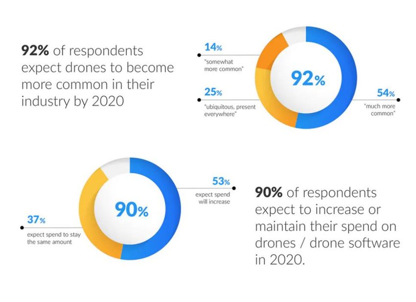
According to the survey, “90% of respondents expect to increase or maintain their
spend on drones and drone software in 2020. Over half (53%) expect to increase
and 37% expect to spend the same amount. Almost a quarter (23.3%) of
respondents expect that spend to grow by more than 50%. Only 5% thought it would
decline.
When it comes to applications: “Protection against risks of all kinds drives 69% of use
cases, including increased safety (29%), risk management (21%), and compliance
(19%). Nearly two-thirds of respondents said that they use drones to “improve
operations” and “increase productivity”. The top three motivators for investing in
drones were desires for increased productivity (68%), improved operations
(66%), and reduced cost(56%).
The Market for UAV Traffic Management Services – 2020-2024. Edition 3.01 March 2020
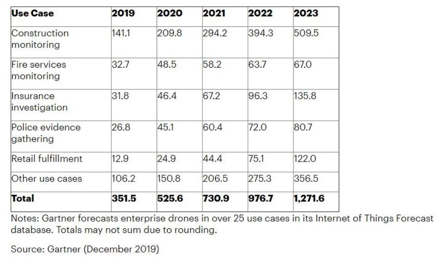
www.unmannedairspace.infoCustomers of DroneDeploy noted the top three benefits were innovation (59%), increased efficiency/speed (57%), and cost-effectiveness (50%). Benefits following closely behind were competitive advantage (44%), improved customer relationships (35%), and safety (25%). DroneDeploy also noted the survey shows the “businesses do not adopt new technology as rapidly as consumers. Companies take deliberate steps to ensure technology is secure, that it will bring quantifiable ROI, and that it will be adopted easily by employees. But consumers aren’t the main opportunity for drone businesses: the CNBC piece reports that the consumer sector will make up just 17% of the drone market in 2020. Rather, the untapped potential for drones lies beyond hardware, hype, and the consumer sector. Businesses, more than ever, are finding value in drone software and in the data generated by the software.” DroneDeploy conducted the survey in December 2019 via an online survey form to its active customers from a sample of over 145 companies across 10+ industries in English. Respondents are paying members of DroneDeploy’s leading drone data platform. In 2020, worldwide shipments of Internet of Things (IoT) enterprise drones will total 526,000 units, an increase of 50% from 2019, according to market forecaster Gartner, Inc. Global shipments are forecast to reach 1.3 million units by 2023. Enterprise drone shipments “The construction sector is an early adopter of drones, which causes construction monitoring to be the largest use case by shipments worldwide across the forecast,” said Kay Sharpington, principal analyst at Gartner. “Shipments are estimated to reach 210,000 drones in 2020, and more than double by 2023. Drones are taking The Market for UAV Traffic Management Services – 2020-2024. Edition 3.01 March 2020 www.unmannedairspace.info
Section three - A country-by-country and regional guide to
programmes creating the procedures and protocols required for
UTM

3.1 Australasia

The Australian Civil Aviation Safety Authority (CASA) has delayed its proposed drone
registration system until mid-2020 in order to allow for industry consultation on fees.
Legislation was passed in July 2019 to introduce mandatory drone registration and
accreditation requirements in Australia, with consultation on fees due to start in late
2019. The changes introduce new requirements for businesses and recreational flyers
and will introduce a cost to register a drone, so CASA said it would consult on the
proposed fees ahead of the scheme’s introduction. To provide industry and
households with adequate time to participate in the consultation of the fees, the
scheme is now expected to commence in phases from mid-2020.

The rules will require all drone flyers to gain an accreditation – that is, watch an
online video and successfully answer a short quiz to demonstrate they understand
the drone safety rules – or hold a remote pilot licence.

A statement by the Australian Association for Unmanned Systems (AAUS) said the
association fully supports the introduction of registration and accreditation but
added the cost needs to be fair and proportionate.

It is proposed that people will need to be 16 years or older to register a drone, with
younger people to be supervised by a person over 18 years old who is accredited.

The online process of drone registration and accreditation is estimated to take
about 15 minutes for most people to complete.

In April 2019 CASA introduced technical requirements for Remotely Piloted
Aircraft (RPA). The new rules are contained in the Part 101 (Unmanned Aircraft
and Rockets) Manual of Standards (MOS) 2019. Primarily they effect commercial
and professional RPA pilots and operators, however, most of these rules will not
come into effect for another 12 months. This is to ensure industry is ready,
particularly RPA training organisations. CASA is currently developing guidance
material to help with the transition, including advisory circulars and templates.

Importantly, two rules have taken effect immediately. The first is the introduction
of specific requirements for the on-going approval of extended visual line of sight
(EVLOS) operations; the second is the requirement for a buffer between any RPA
and any controlled airspace above it.

The other rules due to commence in 12 months include training and
competency standards for remote pilot licences (RePL) and standing approvals
for certain kinds of operations near aerodromes.

The Market for UAV Traffic Management Services – 2020-2024. Edition 3.01 March 2020
www.unmannedairspace.info
Meanwhile, Thales and Telstra, an Australian mobile network provider, have agreed
to partner on low altitude airspace management systems for manned and
unmanned vehicles, such as helicopters, drones and autonomous flying taxis.

“The ambition is to create a robust digital communications network infrastructure
using Telstra’s expertise, to underpin the navigation and surveillance ecosystem
needed to safely manage low altitude airspace,” according to a company press
release. “Thales and Telstra’s prototype air traffic control platform, called Low
Altitude Airspace Management (LAAM) is capable of integrating manned and
unmanned traffic, and will include automated drone flight approvals and dynamic
airspace management. This collaboration will foster the development and growth of
new products, services and innovations. The two companies are currently working
on a prototype system.

In October 2017 Google parent company Alphabet’s Wing began trialling merchant
deliveries in Australia. Following the launch in April 2019 of the first Australian
commercial drone delivery service, Wing announced plans on 31 July 2019 to
expand operations into one of the fastest growing communities in Australia, the
Queensland city of Logan. CASA Corporate Communications Manager, Peter
Gibson said that for each new location a drone delivery operator wants to service
they need to apply to CASA for approvals. In the case of Wing, who already have
approvals for Canberra, he said it will not be a new approval but a variation to the
existing one.

CASA has a set of regulations in place for commercial drone operations but what is
most likely needed for drone delivery are certain exemptions from these rules, such
as “the ability to fly within 30 metres of a person”.

In New Zealand the national air navigation service provider Airways New Zealand
has set up a commercial company AirShare to manage UTM operations throughout
the country.

The UTM system has been fully integrated into the country’s ATM system since 2015.
More recently, AirShare entered into an agreement with Dubai’s Exponent to
provide a new generation of UTM technology and has expanded its service to
include visual line of sight (VLOS) flight authorisations and tracking in both controlled
(around airports) and uncontrolled (everywhere else) airspace. Drone operators
can plan and log flights with AirShare anywhere in New Zealand to determine where
they can legally fly, apply and receive flight approvals, and get awareness about
other airspace users. This includes information on landowner approvals – in New
Zealand, drone operators may often need to understand the approvals process for
flying drones beneath 400ft over some areas of the country where local authorities,
national parks, conservation organisations and others have authority for low level
airspace.

The company has developed Android and iOS mobile apps to access the UTM
system, on a free basis – though the company plans to introduce charges for some
of its services from 2020. The UTM system is integrated with the Leidos ATM system,
enabling approved flights into controlled airspace to be incorporated into the ATCs
dashboard as an electronic flight strip.
The Market for UAV Traffic Management Services – 2020-2024. Edition 3.01 March 2020
www.unmannedairspace.info
In February 2020 AirShare released an updated version of the AirShare app which is
available for download to help drone users to fly safely in New Zealand. AirShare 2.0
is designed for easier flight planning and provides quick access to airspace and
landowner advisories. Other features include wind and weather information, live
location broadcast to other drone users in the vicinity, and historical flight data.
According to the company, only 30 minutes notice is required to receive automatic
provisional authorisations in most of controlled airspace. This includes areas more
than 4km from the controlled aerodrome for flights up to 400 ft, and up to 200ft in
areas within 4km of an aerodrome if you are not operating on an aircraft approach
path or an area where air traffic is commonly routed.
Users can log onto AirShare to see where they can fly, file a flight plan and more
easily gain approvals. The app provides proximity and surveillance data that creates
better situational awareness. Automated text alerts are sent for boundary
infringements. AirShare is one of the building blocks that will support safe UAV
management for New Zealand. Airways is also looking to systems that will ensure
aerodrome safety and a trial of drone detection technologies at Auckland Airport is
ongoing.

Meanwhile in February 2020 the New Zealand Government announced it had
signed a memorandum of understanding with urban air mobility company Wisk
(https://www.urbanairmobilitynews.com/air-taxis/boeing-and-kittyhawk-launch-wisk-
company-to-develop-the-cora-air-taxi/) to support a transport trial of the company’s
Cora air taxi in Canterbury, according to Research, Science and Innovation Minister
Megan Woods. This is reported to be the world’s first autonomous air taxi/airspace
integration trial. The specific details regarding the trial parameters, timeframes, and
the proposed routes are currently being developed in collaboration with local
partners.
In October 2018 UNICEF reported that the Vanuatu Government awarded two
international drone companies, Swoop Aero and Wingcopter, with commercial
contracts to trial the use of drones to bring lifesaving vaccines to children living in
remote rural islands.
Two contracts were awarded to Swoop Aero Pty Ltd of Melbourne, which will cover
vaccine delivery to health facilities on Epi and the Shepherd Islands as well as
Erromango Island. Wingcopter Holding GmbH & Co. KG of Darmstadt, Germany,
was awarded the third contract to deliver vaccines to facilities on Pentecost Island.
The first phase of the drone trials took place during the week of 3-7 December 2018
when these two drone companies tested the viability of delivering vaccines to
inaccessible areas.

The Market for UAV Traffic Management Services – 2020-2024. Edition 3.01 March 2020
www.unmannedairspace.info
5.0 Financing UTM
5.1 Different approaches to financing UTM systems

The December 2019 Notice of Proposed Rulemaking (NPRM) from the FAA setting
out potential charging mechanisms for UTM service suppliers for remote drone ID
services has underlined the principle that tactical UTM service providers will have to
rely on “added extras” rather than “core services” covered by user fees for much of
the future revenue sources.

The FAA assumes each entity operating a UAS would be required to subscribe to a
Remote ID USS at an average rate of USD2.50 per month or US30 per year. If these
costs were applied to the current fleet of drones this would have generated
USD241.72 million – or around USD28.34 million a year. Given that the FAA expects
there to be nine UTM service suppliers (USS) qualified as FAA partners in the first year
of operations this suggests subscription costs will be able to finance only a small
portion of the remote ID service being offered by USSs.

The number of new and renewed Remote ID USS subscriptions is approximately
USD3.1 million for part 107 operators and USD5.7 million for recreational flyers. The
potential commercial operator market in the USA is around 116,000 entities
(https://www.reuters.com/article/us-usa-drones/u-s-agency-requires-drones-to-list-id-
number-on-exterior-idUSKCN1Q12O9) who will provide the main clientele for UTM
services. According to December 2019 FAA figures there are 1,509,617 drones
registered in the USA, 420,340 commercial drones registered, 1,085,392 recreational
drones registered and 160,748 remote pilots certified. While USS companies will
already have established relationships with this community how will they define their
own unique selling points over their competitors?

As the FAA will not provide payment for the development or operation of Remote ID
USS products or services it anticipates that “the Remote ID USS would recoup the
costs of providing services either through the sale of subscriptions for remote
identification services, online advertising, or “value added” services that can be
purchased from the service provider.” But which added value services and would
these be produced by the USS or in partnerships?

Unless they have already done so, UTM service providers will need to build scalable
strategic partnerships with internet service providers and mobile phone companies
in ways that everyone can make money

The proposed rule would require persons operating UAS with remote identification to
transmit the remote identification message elements to a Remote ID USS over the
internet. For most USS this is not a technical problem. But it becomes a business issue
as the FAA appears to require UTM to be based on increasing numbers of scalable,
certified telecommunications services (“The FAA anticipates that in the future, third
parties may develop mobile phone applications for law enforcement use…the FAA
anticipates that some UAS manufacturers will also be Remote ID USS. In those cases,

The Market for UAV Traffic Management Services – 2020-2024. Edition 3.01 March 2020
www.unmannedairspace.info
6.4 Sense-and-avoid (SAA)

Compared to the issues of tracking/identification and communications, developing
appropriate sense-and-avoid technologies appears a relatively easy task. First, there
is a plethora of commercial sense-and-avoid systems for drones now entering the
market. Second, there are fewer major industry v regulator issues impacting this
sector than there in other sub-sectors – either the technology will work after it has
been assessed, or it will not.

The NASA/FAA research team subgroup working on:

   •   Effectiveness of operational coordination through sharing intent information in
       combination and in contrast to active avoidance, and through SAA
       capabilities;

   •   Considering relative performance of both navigation and SAA capabilities;

   •   Analysing the trade-space between sensing and detection capability of UA
       versus the UA’s capability to manoeuvre;

   •   Evaluating technology options for sharing positioning information in use cases.
       Potential considerations for radio frequency and network capacity,
       interoperability, density of operations, priority of positioning information on
       technology, reliability, etc. Exploring industry-wide solutions sets for near-term
       and longer-term operations;

   •   Exploring options for reporting on issues pertaining to SAA. Document best
       practices for operators and capture any recommendations for regulator
       macro-collection efforts, and

   •   Evaluating operational corrective processes. With consideration for SAA,
       investigate data collection processes that could be used to take lessons
       learned to reinforce operational compliance. Potential considerations for
       data exchange between operator and UA manufacturer.

Flight Test Series 6 (FT6), at NASA Armstrong Flight Research Center in California is
part of its work to assist the FAA develop regulations to allow the integration of UAS
into the National Airspace System (NAS).

The UAS Integration in the NAS project is managing the three-monthlong flight tests
that are scheduled between September and November 2019.

According to NASA, FT6 will focus on low size weight and power (SWaP) sensors for
Detect and Avoid (DAA) operations in controlled airspace to inform the FAA through
the RTCA Special Committee DAA Working Group on the phase 2 minimum
operational performance standards for DAA and air-to-air radar.

FT6 will use the TigerShark Block 3 XP, a NAVMAR Applied Sciences
Corporation (NASC), Group 3 UAS with a wingspan of 21.9 feet for the final test
series. The TigerShark features a payload capacity of 95 lbs. and a maximum
The Market for UAV Traffic Management Services – 2020-2024. Edition 3.01 March 2020
www.unmannedairspace.info
endurance of 12 hours. The TigerShark XP has been modified with a unique smoke system to help intruder aircrew visually acquire the aircraft during flight tests and a nose structure to integrate Honeywell’s radar system. The Digital Active Phased Array, or DAPA-Lite radar system, is a new technology compared to previous flight series. The radar system consists of three small radar panels whose radar beams can be electronically steered to point in different directions without the need of moving antennas. The three panels are arranged to provide a wide horizontal field of view. “The radar system is cutting-edge technology with panels small enough to be carried on a smaller UAS, but still have enough range to see and avoid other aircraft,” said FT6 DAA Principal Investigator Michael Vincent. “Our goal for FT6 is to challenge the effectiveness of our DAA system and Honeywell’s radar system as we develop performance standards of unmanned aircraft being integrated in our national airspace system.” A primary objective for the project team is to characterize Honeywell’s DAPA-Lite radar to determine its effectiveness and its range and accuracy. The team will be testing what the radar can actually detect with its low size weight and power radar system. The DAPA-Lite radar will provide the data to the DAA system to determine the distance, bearing and elevation between the UAS and other aircraft. The DAA system will then use the information from the radar system to determine which flight path to take to maintain safe separation. FT6 will help establish the minimum operational performance standards for DAA systems for UAS in the NAS. The system must alert the pilot in a timely manner when a conflict occurs and determine which display elements the pilot needs to be aware of in order to guide the TigerShark away from potential danger. Three intruders will be used during the flight tests each representing a different common size aircraft that a UAS may encounter in the NAS, the King Air B200, T- 34C and TG-14 Motor Glider. Some flight tests will require an intruder aircraft to fly on the same path head-on toward the TigerShark with a safety separation buffer. This particular encounter will demonstrate the effectiveness of the DAA alerting system and what type of guidance it will recommend to avoid the intruder. The flight series includes 150 encounters in 26 flights, which consists of six radar characterization flights, 12 DAA scripted encounter flights and eight full mission encounter flights. Each full mission encounter flight will feature a different pilot that is naïve to the FT6 objectives and encounters to gather accurate data on how a pilot will react and respond to the systems. Pilots will fly a simulated UAS mission and interact with an air traffic controller and other traffic (live and virtual) in the airspace. The pilot will be tasked with using the DAA system to avoid live aircraft that the DAPA-Lite radar detects. The Market for UAV Traffic Management Services – 2020-2024. Edition 3.01 March 2020 www.unmannedairspace.info
“Every decision we have made for FT6 was a result of what we have learned in
previous flight tests,” added Vincent. “Our journey through each flight test series has
been instrumental in the hopes of allowing unmanned aircraft to enter
unsegregated airspace in the near future. FT6 will be a big factor on how we can
safely integrate unmanned aircraft.”

NASA’s participation includes Armstrong, and researchers from Ames Research
Center in California, and Langley Research Center in Virginia.

Meanwhile, several different flying encounter scenarios were tested using manned
and unmanned aircraft at the New Mexico State University (NMSU) Physical Science
Laboratory test site at Jornada Experimental Range from 16-18 July 2019. The flight
tests are part of a US Federal Aviation Administration (FAA) project to examine
“Small UAS Detect and Avoid Requirements Necessary for Limited Beyond Visual Line
of Sight Operations: Separation Requirements and Testing”. The range is one of
seven FAA-approved unmanned Aircraft Systems test sites designated to test
airborne, ground-based, visual/optical systems, radar and acoustic technology
solutions.

Two types of UAS, a multi-rotor and a fixed wing, fitted with detect and avoid
equipment, and two manned, NMSU vehicles, the CTLS Light Sport aircraft and
Spyder Ultralight aircraft, which posed as the intruder aircraft, were used in the flight
testing. An AI-based autonomous collision avoidance system from Iris Automation
called Casia was used on the UAS to detect manned aircraft and respond with an
avoidance manoeuvre.

Considerations for encounter scenarios included safe separation distances between
vehicles of at least 100 feet in lateral separation and 250 feet in vertical separation.
The vehicles conducted tests at different encounter angles and cross patterns.
Flights were conducted at two altitudes: 100 feet for the UAS and 500 feet for the
manned along with 400 feet for the UAS and 650 feet for the manned. The testing
assessed when the Iris system was triggered and its limits.

Flight information on both the UAS and manned vehicles was collected, and the
research team is due to plot together the information to show the encounters in the
coming weeks. NMSU then plans to provide the FAA with details about the
performance of the technology. FAA UAS technical project lead Bill Oehlschlager
said: ““We have several more flight test events before we actually come up with a
comprehensive plan, but we are using each flight test event to further expand the
data we need to collect and how the operations need to run. We are using each
incremental step to collect more data and make it safer for when we actually do
this testing.”

Officials present for the testing included NMSU personnel, FAA sponsors, FAA
technical leads, FAA interns, Iris Automation flight personnel, industry representatives,
UND and UAF personnel.

As one of 15 core universities for the FAA UAS Center of Excellence, NMSU is also
working with the University of North Dakota, University of Alaska Fairbanks, Kansas

The Market for UAV Traffic Management Services – 2020-2024. Edition 3.01 March 2020
www.unmannedairspace.info
State University and Mississippi State University on the research project. NMSU, UND
and UAF are each hosting flight testing on detect and avoid solutions.

In this research area, NMSU is evaluating the requirements for an airborne or ground-
based Detect and Avoid system compatible with small UAS (55 pounds and less)
operating in limited portions of the National Air Space to comply with the regulations
and not increase the risk to other aircraft or people on the ground, beyond what is
currently in effect. Additionally, NMSU is accessing the requirements for software
along with what are the most feasible airborne or ground-based sensors.

In terms of industry research, in May 2018 AirMap and Wing report they have
successfully demonstrated a solution to safety-critical airspace deconfliction
challenges as part of the ongoing NASA-UTM trials. AirMap joined Wing and ANRA
technologies to test TCL3 concepts, including failover recovery, remote
identification, dynamic weather conditions, contingency planning, and USS-to-USS
communication for multiple drone operations.

According to AirMap: “During the trial, AirMap provided UTM services to a senseFly
eBee and an Intel Aero, while Wing powered separate Intel Aeros, a DJI Inspire, and
their own delivery drone. AirMap and Wing UTM systems successfully planned and
de-conflicted flight plans within the same airspace using an open source,
distributed, peer-to-peer system to perform a multitude of missions, including surveys
and package delivery in close proximity. Throughout the flights, AirMap and Wing
UTM systems demonstrated inter-USS communication such as real-time telemetry
and notifications to ensure compliance and safety across the entire multi-USS UTM
environment.

“Inter-USS communication is among the most technically challenging of capabilities
demonstrated in TCL3,” said AirMap. “At scale, drones will be operating
simultaneously in a wide variety of commercial applications like search-and-rescue,
industrial inspection, and logistics. In these applications, drones will be operating in
shared dimensions, connected to a variety of USS platforms. These USS platforms
need to be able to talk to each other to manage drone traffic safely and efficiently
in congested airspace. The technology demonstrated in TCL3 serves as a foundation
for information exchange between USSs to enable a cooperative and scalable low-
altitude airspace system.”

Thus research led to the announcement in June 2018 at the GUTMA annual
conference in Madrid that five UAS service suppliers (USSs) have joined together
under the sponsorship of Google’s Wing to develop a global, grid-based USS-USS
open-source communications platform, called InterUSS Platform ™ as a first stage in
de-conflicting drone flights anywhere in the world, no matter which USS has the
authority for UTM operations in a particular country or area.

The system divides the world into 750m grids; when a drone connected to a UTM
platform provided by AirMap, Altitude Angel, PrecisionHawk, Skyward, Unifly and
Wing enters the grid a message will be sent to other USS operators to alert them. The
system uses the Apache License permissive free software, to allow de-confliction
operations to take place on a machine-to-machine basis, using the algorithms

The Market for UAV Traffic Management Services – 2020-2024. Edition 3.01 March 2020
www.unmannedairspace.info
developed by each service provider, and will be opened up to new partners in the
coming months, with Global UTM Association (GUTMA) providing support in this area.

Meanwhile, the EUROCAE standards team plans to deliver tactical mitigation
standards against conflicting traffic for RPAS operating under IFR and VFR in all
airspace classes by September 2018. JARUS is also working on a document that
describes the methods to derive design objectives for DAA systems based on
airspace requirements.

In November 2019 NASA’s Langley Research Center started using FLARM traffic
awareness and collision avoidance technology in its Pathfinder drone UTM
project. The goal of Pathfinder is to take separate UTM projects and combine them
into a single autonomous concept to enable vehicles to fly and communicate with
other autonomous vehicles in the airspace. “Pathfinder was conceived as a way to
perform a graduation exercise for a lot of the UTM projects we developed over the
years,” said Lou Glaab, assistant branch head for the Aeronautic Systems
Engineering Branch in Langley’s Engineering Directorate and Pathfinder project
manager. Part of that graduation exercise is the Independent Configurable
Architecture for Reliable Operations of Unmanned Systems (ICAROUS).

“We’re testing things like ICAROUS, which is an autonomous sense and avoid flight
management system for unmanned systems, as well as Safe-2-Ditch, which is an
autonomous safe landing or autonomous crash management system,” said Glaab.

FLARM is being used as part of ICAROUS both to avoid manned aircraft as well as
other drones.

“To operate autonomously you need several capabilities, especially in the UAS
domain,” said Swee Balachandran, research engineer. “You need to be able to
make decisions to avoid other intruders in the air space, stay clear from no-fly zones,
or inside a no-fly zone the UAV should know how to get out of it and to re-route itself
around obstacles and no-fly areas.”

Balachandran also said that these functionalities are essential to operate
autonomously without human intervention. ICAROUS supports this concept with
formal verification. “Every algorithm that you develop goes through a rigorous
mathematical process and we have certain properties, and we ensure the
algorithms satisfy those properties so that it is safety-critical and you don’t see
unwanted behaviours in flight,” said Balachandran.

In August 2018 uAvionix and Flarm Technology announced a partnership to
collaborate on Electronic Conspicuity (EC) and Detect and Avoid (DAA) solutions for
manned and unmanned aircraft. uAvionix specialises in ADS-B, Secondary
Surveillance Radar (SSR) transponders, and GNSS position sources for manned and
unmanned aircraft. Flarm specialises in situational awareness and active DAA
solutions for general aviation and unmanned aircraft. Both companies offer
products for installation and portable use together with modern display systems such
as Electronic Flight Bag (EFB) applications.

The Market for UAV Traffic Management Services – 2020-2024. Edition 3.01 March 2020
www.unmannedairspace.info
The companies plan to incorporate their respective technologies into one another’s
products and to develop and sell interoperable solutions for these markets across
the world. The companies also plan to collaborate on UAS remote identification
standards and solutions. Flarm’s Open eID Standard, the electronic identification
standard published globally, is being trialled in Europe for DAA and remote
identification purposes, a key enabler for UTM frameworks like U-space.
uAvionix’s DroneAware® system is being tested as a component of the NASA UTM
TCL3 demonstrations as well as three of the UAS Integration Pilot Programs in the US.
“As the airspace becomes more and more crowded, it is increasingly important to
integrate existing electronic conspicuity solutions into interoperable platforms. ADS-B
and Flarm are the two dominating GNSS-based solutions in use today” said Christian
Ramsey, President uAvionix.
“Combining Detect and Avoid and remote ID solutions for both manned and
unmanned traffic will enable the safe and efficient integration of all traffic in the
same airspace and keep the responsibility where it should be: with the pilot,” said
Daniel Hoffmann, General Manager Flarm Technology.
A month later, uAvionix announced the release of its 1090nano, a 1090MHz ADS-B
single chip solution for Unmanned Aircraft Systems (UAS) ADS-B transceivers and
detect and avoid (DAA) applications. In early 2017, uAvionix introduced its T-UAT, a
dime-sized 978MHz single chip which has become the cornerstone for all of
uAvionix’s 978MHz ADS-B solutions, for both manned and unmanned solutions,
including the recently TSO certified skyBeacon. When paired with the T-UAT,
the 1090nano will offer dual-band ADS-B receiver functionality at a size, weight, and
power (SWaP) never before achieved.
“1090nano isn’t just the latest addition to our expanding product line,” said Paul
Beard, uAvionix’s chief executive officer, “It represents another affordable safety-
enhancing solution, like T-UAT in 2017 and the recently TSO-
certified skyBeacon, which we’ve been able to develop thanks, in no small part, to
the significant financial backing of two major investors, Playground Global
and Airbus Ventures,” Beard said.
“Both T-UAT and 1090nano chipsets are capable of transmitting ADS-B messages at
very low power, at a range of 0.01-0.25W, which translates to roughly 1-10 miles,”
Beard added. “Our plans for 1090nano include incorporation into current and future
certified 1090MHz Mode C and S transponders, as well as low power detection and
avoidance solutions for UAS. We introduced a Patent Pending concept we
dubbed Inert and Alert In March of 2018 that offers low power, spectrum saving and
safety solutions. The release of 1090nano further broadens this concept.”
Also in August 2018 Echodyne announced it had received Federal Communications
Commission (FCC) certification for its EchoFlight radar, an airborne detect and avoid
radar designed for integration into a wide-variety of UAS platforms.
“For organisations seeking authorisation to operate beyond visual line of sight or
autonomously, EchoFlight radar is a significant step forward for UAS mission safety,”
says a company statement.
According to Eben Frankenberg, CEO of Echodyne: “Our compact, solid-state,
lightweight yet powerful radar offers the ability to scan large volumes of airspace
and track other aircraft with sufficient range to maintain safety.”

The Market for UAV Traffic Management Services – 2020-2024. Edition 3.01 March 2020
www.unmannedairspace.info
In October 2018 Raytheon reported it was close to completing the safety case for
the company’s Ground Based Detect and Avoid (GBDAA) system, used by the US
Air Force and also demonstrated at Springfield-Beckley Municipal Airport in Ohio.
The ground-based detect and avoid (GBDAA) capability uses existing air traffic data
from multiple sources to provide Unmanned Aerial System (UAS) operators with a
real-time display of aircraft in the surrounding airspace. GBDAA alerts operators to
potential conflicts with neighbouring aircraft and recommends avoidance
manoeuvres for UAS in the event of a conflict.
The US Air Force has used GBDAA in place of ground observers or chase aircraft at
Cannon Air Force Base in New Mexico to allow safe passage of UAS to a military
operations area via civil airspace since 2014. Raytheon is currently installing the
equipment at Beale Air Force base in California to eliminate a temporary flight
restriction area, followed by Grand Forks Air Force Base in North Dakota. A mobile
version of the equipment was recently deployed in Ohio to help accelerate the safe
integration of drones into the national airspace: Here, GBDAA supports small UAS
operating beyond visual line of site (BVLOS) in an area that extends some 200 square
miles.
The Volpe Centre is supporting deployment of the mobile version of GBDAA for the
joint project between US Air Force Research Labs and the State of Ohio. The
programme is building a safety case for the Federal Aviation Administration (FAA),
and providing a mobile common centre able to respond in the case of a natural
disaster.
The main component of GBDAA is a modified FAA terminal automation system
equipped with Raytheon’s Standard Terminal Automation Replacement System
(STARS) that ingests and displays surrounding aircraft to a UAS operator. GBDAA
leverages existing NAS radar equipment and infrastructure to locate surrounding
aircraft and can also take feeds from infill radar designed to track small UAS.
Conflicts are brought to the attention of the controller using three levels of alert with
visual and audio alarms. The mobile unit features also a data link capability that
enables position data based on GPS information to be sent by UAS operators to the
command unit.
Raytheon believes GBDAA can help support their safe integration into national
airspace and enable both manned and unmanned aircraft to follow the most direct
and safe routes. Replacing the need to fly in segregated airspace could also help to
reduce the size of restricted military areas.
Also in November, Aerobits Poland signed a strategic co-operation agreement with
Flarm Technology Ltd., specialist in the production of anti-collision systems for
general aviation. The aim of this agreement is the miniaturisation of fused Flarm and
ADS-B technology together with its transfer into unmanned systems. The scope of the
actions also includes development of high-sensitivity stations for the ground
infrastructure and sub-miniature OEM modules, incorporating in its structure three
technologies: GNSS/ADS-B/FLARM. “Those new solutions are critical to integrate
unmanned traffic management (UTM) with air traffic management (ATM). Aerobits
already cooperates with UTM suppliers such as DroneRadar and Unifly by
providing transponders and ADS-B infrastructure necessary to develop, test and
implement the U-space concept.

The Market for UAV Traffic Management Services – 2020-2024. Edition 3.01 March 2020
www.unmannedairspace.info
In December 2018 Unmanned Systems Technology reported that the Northeast UAS
Airspace Integration Research Alliance (NUAIR) had announced the successful
demonstration of a new Airborne Collision Avoidance System (ACAS) for small
unmanned aircraft systems (UAS).
“The first-of-it-kind test flights for ACAS sXu (the newest member of the ACAS X family
designed specifically for small unmanned aircraft) were held at Griffiss Airport in
Rome, New York,” says the news site. “The system is a smaller and more compact
version of the next generation ACAS X, an airborne collision avoidance system now
under development for large passenger and cargo-carrying aircraft. The tests
showed the system has the unique ability to detect and avoid other aircraft, both
manned and unmanned. The flight tests were a collaboration between AiRXOS, a
GE venture, Fortem Technologies, GE Aviation, GE Global Research, Johns Hopkins
University Applied Physics Lab, MIT Lincoln Laboratory, the FAA TCAS Program Office,
AX Enterprize, the New York UAS Test Site in Oneida County and NUAIR Alliance.
“During flight, detect and avoid capabilities use information from airborne and
ground-based sensors to make pilots aware of potential collision risk and provide
guidance to ensure a safe outcome. The ACAS sXu system is specifically designed to
do this by providing back-up collision avoidance to provide an additional layer of
safety beyond existing air traffic control systems and flight procedures.
“These features are key toward commercialisation of UAVs and urban air mobility.
Furthermore, the ACAS tests specifically showed that the system could be run as an
airborne system, as well as a cloud-based system inside of the unmanned aircraft
systems traffic management (UTM) architecture, with similar detect and avoid
abilities.”
Also in December 2018 Boeing conducted a flight experiment to test the concept of
expanding radar capabilities to UAS at the headquarters of Aurora Flight Sciences, a
Boeing subsidiary, in Manassas, Va. The addition of an airborne radar to Boeing
subsidiary Insitu’s Inexa Access – Ground Detect and Avoid system creates a
common operating picture that enables UAS operators to better visualise the
surrounding air traffic and ensure they stay well clear of other aircraft.
The Boeing team equipped an Aurora Centaur optionally-piloted aircraft with a
small radar to serve as a UAS surrogate mimicking Insitu’s ScanEagle3. Using a
second Centaur and Cessna 172 as “intruder” aircraft within the same airspace, the
team flew collision-type flight profiles and recorded the data.
GPS data from all three aircraft allowed the team to determine the accuracy of the
aircraft location data derived from the airborne radar.
The radar technology used in this experiment comes from Fortem Technologies, Inc.,
a Salt Lake City, Utah-based company developing advanced radar systems for
unmanned and manned aircraft. Boeing HorizonX Ventures invested in Fortem to
support the growth of its airspace awareness solutions that ensure safe operations of
UAS.

In April 2019 Kongsberg Geospatial announced it had developed IRIS UxS Fleet
Control Station technology to enable multiple drones to be monitored and
controlled simultaneously by a single operator and provides real-time calculation
of aircraft separation, airspace monitoring alerts and communications line-of-
sight prediction to enable detect and avoid for safe BVLOS operations.
The Market for UAV Traffic Management Services – 2020-2024. Edition 3.01 March 2020
www.unmannedairspace.info
According to the company the IRIS FCS integrates a variety of real-time data
feeds including ADS-B, local radar and National Airspace Feeds to calculate
“detect and avoid” warnings. IRIS provides real-time 2D and 3D visualization of
airborne track and weather data, as well as geo-fencing capabilities. IRIS UAS is
an airspace situational awareness system developed to provide Unmanned
Aerial Systems (UAS) operators with the necessary situational awareness to safely
operate multiple Unmanned Aerial Vehicles (UAVs) Beyond Visual Line-of-Sight
(BVLOS). The platform presents users with 2D and 3D map and terrain data,
aeronautical information such as aerodrome locations, obstacles and airspace,
and real-time data from sensors, cameras, and weather data sources – all
integrated within a single, common operating picture display. The IRIS UxS
technology provides enhanced BVLOS situational awareness to MicroPilot
autopilot users flying multiple UAS per operator. MicroPilot develops and
manufactures autopilots for fixed, rotary wing and hybrid UAVs, including the
triple redundant MP21283X.

Also in April 2019 uAvionix announced a partnership with CubePilot, designer and
manufacturer of “the Cube” autopilot for Unmanned Aircraft Systems (UAS) – to
integrate ADS-B IN receive capability into its Carrier Board. The new Carrier
Board, available in July this year, integrates uAvionix’s custom ADS-B silicon for
1090MHz ADS-B reception for worldwide Detect and Avoid (DAA)
functionality. CubePilot, which proudly uses the open-
source ARDUPILOT platform, previously provided plug-and-play functionality for
several uAvionix ADS-B IN and OUT products,
including PingRX, Ping2020i and Ping1090i. Support for these products is retained
in the new design, allowing for 978MHz ADS-B reception or integration of ADS-B
OUT functionality.

“With this integration, UAS operators will be able to see nearby ADS-B OUT
enabled aircraft on ARDUPILOT’s Mission Planner, allowing the Remote Pilot in
Command (RPIC) with timely notification to take the necessary actions to remain
well clear,” said a company press release.

According to Christian Ramsey, uAvionix President. “We believe that ADS-B IN
functionality should be a requirement for every DAA system for UAS operations
over people or Beyond Visual Line of Sight, and meeting that requirement should
not be cost prohibitive.”

The Market for UAV Traffic Management Services – 2020-2024. Edition 3.01 March 2020
www.unmannedairspace.info
7. Market forecasts for growth in the global UTM market – by value,
geographic demand and sectors

Table twenty-two: UTM service providers and commercial contracts with ANSPs, civil
aviation authorities
                     UTM service
 Date                               Client           Country      Contract details
                     supplier

                                                                  Public launch of the
                                                                  Exponent Portal
                                                                  software which
                                    Dubai Civil                   allows DCAA officials
 April 2016          Exponent       Aviation         Dubai        and other local
                                    Administration                authorities to track
                                                                  the location, speed
                                                                  and height of
                                                                  drones.

 2017

                                                                  UTM deployment
 July                Unifly         DFS              Germany      with mobile app in
                                                                  July 2017

                                                                  The AirMap UTM
                                                                  platform is deployed
                                                                  in Kansas where
                                    Kansas                        drones will be
                                    Department                    mobilised for disaster
 August              AirMap         of               USA          recovery, search-
                                    Transportation                and-rescue,
                                    (KDOT)                        agriculture,
                                                                  construction,
                                                                  package delivery,
                                                                  and more.

                                                                  Temporary UTM set
                                    States of
                                                                  up in wake of
 August/September    AirMap         Texas and        USA
                                                                  hurricanes Harvey
                                    Florida
                                                                  and Irma

                                                                  A contract to
                     Kongsberg      Public                        produce an
 September                                           Canada
                     Geospatial     Services and                  Emergency
                                    Procurement                   Operations Airspace
                                                                  Management

The Market for UAV Traffic Management Services – 2020-2024. Edition 3.01 March 2020
www.unmannedairspace.info
Canada System (EOAMS) for
(PSPC) evaluation by
Canadian
government
agencies for safely
managing drones at
emergency and
disaster scenes.
Approval to give
commercial drone
operators instant
Federal access to controlled
October Skyward Aviation USA airspace with the
Administration Low Altitude
Authorisation and
Notification
Capability (LAANC)
Launch of
Danish
“Droneluftrum” app
Transport,
centred on
October Unifly Construction Denmark
interactive map
and Housing
based on Unifly
Authority
software
Approval to give
commercial drone
operators instant
Federal access to controlled
November AirMap Aviation USA airspace with the
Administration Low Altitude
Authorisation and
Notification
Capability (LAANC)
Drone operators use
AirMap’s iOS and
Android apps to
request airspace
approvals required
Airways New New by New Zealand’s
December AirMap Civil Aviation
Zealand Zealand
Authority at
Christchurch,
Queenstown, and
Wanaka airports,
and on public lands
in the Christchurch
City, Selwyn, and
The Market for UAV Traffic Management Services – 2020-2024. Edition 3.01 March 2020
www.unmannedairspace.infoQueenstown Lakes
District Council,
including parks and
reserves.
Chiba City is the first
city in Japan to
Rakuten deploy the Airspace
December Chiba City Japan
AirMap Management
Dashboard from
Rakuten AirMap.
UTM deployment
December Unifly Austrocontrol Austria
with mobile app
2018
Belgocontrol Launch of
and the droneguide.be, a
March Unifly Belgian Civil Belgium digital platform
Aviation based on Unifly
Authority software.
Approval to give
commercial drone
operators instant
Federal access to controlled
March Wing Aviation USA airspace with the
Administration Low Altitude
Authorisation and
Notification
Capability (LAANC)
Approval to give
commercial drone
operators instant
Federal access to controlled
Rockwell
March Aviation USA airspace with the
Collins
Administration Low Altitude
Authorisation and
Notification
Capability (LAANC)
Deutsche The UTM system is
March DFS Germany
Telecom based on the DFS
The Market for UAV Traffic Management Services – 2020-2024. Edition 3.01 March 2020
www.unmannedairspace.info7.1 UTM market forecasts by value, geographic demand and sectors – 2019-
2023
Table twenty-three: Comparing market forecasts
2019 2020 2021 2022 2023 2024
Shipments of Gartner 351.5 525.6 730.9 976.7 1,271.6 -
commercial
drones Dec (50%) (39%) (33%) (30%)
2019
(CAG)
Total drone IDC - USD16.3 USD21.7 USD28.9 USD38.5 USD51.3
expenditure Jan
2020 (33.3%) (33.3%) (33.3%) (33.3%) (33.3%)
(USD billion)
(CAG)
Commercial Teal USD4.9 USD 5.5 USD6.2 USD7.0 USD7.9 USD8.9
drone
expenditure Jun (12.6%) (12.6%) (12.6%) (12.6%) (12.6%)
(USD billion) 2019
(CAG)
Total drone Azoth - - - - - -
expenditure
Jan
CAG 2019
between
2019-2024
43.1%
US civil FAA 400 545 711 789 - -
drone fleet –
base Apr (36.2%) (30.4%) (10.9%) (8.3%)
forecasts 2019
(000s)
(CAG)
Commercial Tractica 2.0 2.85 4.0 5.0 7.25 9.0
drone
hardware Oct (42.5%) (40.3%) (25.0%) (45.0%) (25.0%)
and 2019
software
(USD billion)
CAGR
The Market for UAV Traffic Management Services – 2020-2024. Edition 3.01 March 2020
www.unmannedairspace.info8. The Urban Air Mobility UTM market 8.1 Introduction to the UAM market The first global, detailed, city-by-city analysis of urban air mobility investment costs, revenue potential and infrastructure requirements has been completed by Washington DC-based corporate and strategic financial consultancy NEXA Advisors. NEXA has researched detailed infrastructure requirements for 74 cities around the world which are most likely to pioneer urban air mobility operations. The upfront infrastructure investments for UAM heliports, vertiports, mega‐ports and airport landing sites – including passenger services, security and UAS traffic management services – will require more than USD30 billion in capital between today and 2040 but will generate direct income of around USD 318 billion, say the report authors, and total direct and indirect income of around USD600 billion. The team estimates that there will be approximately 1.29 billion passengers flying the analyzed services in the 74 cities within the 20 year forecast period. There will be an initial foundation service period followed by an “Inflection Point” when the market starts to accelerate steeply brought about by increasing use of automation. “Operator revenues brought about from substantial passenger demand of about 1.3 billion passenger flights yield USD244 billion across all 74cities,” says the report. This represents a 20 year average ticket price of USD188 per passenger. “A capital investment along with operating costs for UAM and AUTM infrastructure is estimated to be about USD31.9 billion. eVTOL vehicle sales should surpass USD41 billion, representing many tens of thousands of vehicles.” “The full potential of UAM will be achievable only with higher levels of automation of eVTOL flight, dynamic airspace access through geofencing, UATM oversight, sense‐ and‐avoid surveillance and vehicle interoperability,” continues the study. “It is not difficult to visualize that cockpit automation will be necessary to improve the safety of flight, and drive costs – and ticket prices – down. The Inflection Point for the industry will occur in multiple phases toward the end of the first decade….However, the ability of vehicle manufacturers to demonstrate and certify safe automated flight to greater than [10‐9] is a critical milestone, and as this will require logging hundreds of thousands of demonstration flight hours, starts now (and it has already begun).” The study includes a detailed city-by-city infrastructure planning analysis using satellite imagery and the ArcGIS geographic information system produced and maintained by ESRI. For each city infrastructure costs have been analysed and forecast, as well as potential passenger numbers (see below). NEXA has detailed the costs of developing and implementing ground infrastructure and UTM services in the individual cities. The Market for UAV Traffic Management Services – 2020-2024. Edition 3.01 March 2020 www.unmannedairspace.info
You can also read