Transit-Oriented Development: Towards Achieving Sustainable Transport and Urban Development in Jakarta Metropolitan, Indonesia - MDPI
←
→
Page content transcription
If your browser does not render page correctly, please read the page content below
sustainability

Article
Transit-Oriented Development: Towards Achieving Sustainable
Transport and Urban Development in Jakarta
Metropolitan, Indonesia
Hayati Sari Hasibuan 1, *                 and Mari Mulyani 1,2

                                           1   Research Center of Spatial Planning and Transit Oriented Development, School of Environmental Science,
                                               Universitas Indonesia, Jakarta Pusat 13420, Indonesia; mari.mulyani@ouce.ox.ac.uk
                                           2   School of Geography and the Environment, University of Oxford, Oxford OX1 3QY, UK
                                           *   Correspondence: hayati.hasibuan@ui.ac.id

                                           Abstract: Transit-Oriented Development (TOD) is advocated for achieving sustainable transporta-
                                           tion through development around transit stations. TOD’s global implementation revealed varied
                                           outcomes, with many cities failing to achieve the intended objectives. TOD implementation in the
                                           Jakarta Metropolitan area still in its infancy. Through a geospatial information system and a survey of
                                           400 commuters who live inside the 1 km radius of planned TOD, this longitudinal study aimed to ex-
                                           amine an eight-year lapse between 2013 and 2020 of changes in two aspects, specifically land-use and
                                           spatial distribution as well as commuters’ travel behavior and preferences in TOD implementation
                                           and travel changes due to the COVID-19 pandemic. Key findings are as follows: increased diversity
                                           in the residential function around planned TOD areas in the Jakarta capital and a decrease in the
                                           suburbs, reflecting the commuters’ improved readiness to reside in planned TOD areas. Furthermore,
                                           kinship relations were the commuters’ main reason when selecting house locations, with no capacity
                                           to change their workplaces. A significant increase in public facilities at the expense of green open
                                           space (GOS) indicates that TOD implementation was conducted by the government with the sole
Citation: Hasibuan, H.S.; Mulyani,         authority to manage GOS, lacking private sector involvement. The cost factor was the most dominant
M. Transit-Oriented Development:           reason for the commuter’s use of public transportation, instead of new transport modes such as
Towards Achieving Sustainable              MRT and LRT. Moreover, the commuter’s travel behavior in all studied transit stations, whilst it
Transport and Urban Development in         showed evidence of changes in time and frequency, was not greatly influenced by the COVID-19
Jakarta Metropolitan, Indonesia.           related restrictions.
Sustainability 2022, 14, 5244. https://
doi.org/10.3390/su14095244
                                           Keywords: Transit-Oriented Development (TOD); Jakarta metropolitan; commuters; travel behavior;
Academic Editor: Armando Cartenì           land-use diversity; COVID-19 pandemic; urban environment sustainability

Received: 6 April 2022
Accepted: 22 April 2022
Published: 26 April 2022
                                           1. Introduction
Publisher’s Note: MDPI stays neutral
                                                 The Transit-Oriented Development (TOD) policy triggered debates within sustainable
with regard to jurisdictional claims in
                                           urban development in the early 1990s. The concept aimed to address urban transportation
published maps and institutional affil-
                                           issues, including severe traffic congestion, by combining urban land-use and transport
iations.
                                           systems [1]. TOD manages people’s mobility by decreasing trip distances and maximizing
                                           transport service efficiency by concentrating urban development around transit stations [2].
                                           The key TOD characteristics advocated are high density, being pedestrian-friendly, and
Copyright: © 2022 by the authors.
                                           mixed-use space following the widely known three ‘D’ aspects of density, diversity, and
Licensee MDPI, Basel, Switzerland.         design [3,4]. Subsequently, they became 5Ds, including density, diversity, design, desti-
This article is an open access article     nation accessibility, and distance to transit [5]. TOD policies aim to achieve a sustainable
distributed under the terms and            land-use and transport system through enhancing accessibility by providing high-level
conditions of the Creative Commons         transport connections [6–8]. This would attract people to use public transport, reducing
Attribution (CC BY) license (https://      traffic congestion, energy consumption, and air pollution [9].
creativecommons.org/licenses/by/                 Extensive literature has assessed TOD’s effectiveness by examining its key components,
4.0/).                                     including the connection of transit stations and land-use density, diversity, and proximity to

Sustainability 2022, 14, 5244. https://doi.org/10.3390/su14095244                                       https://www.mdpi.com/journal/sustainability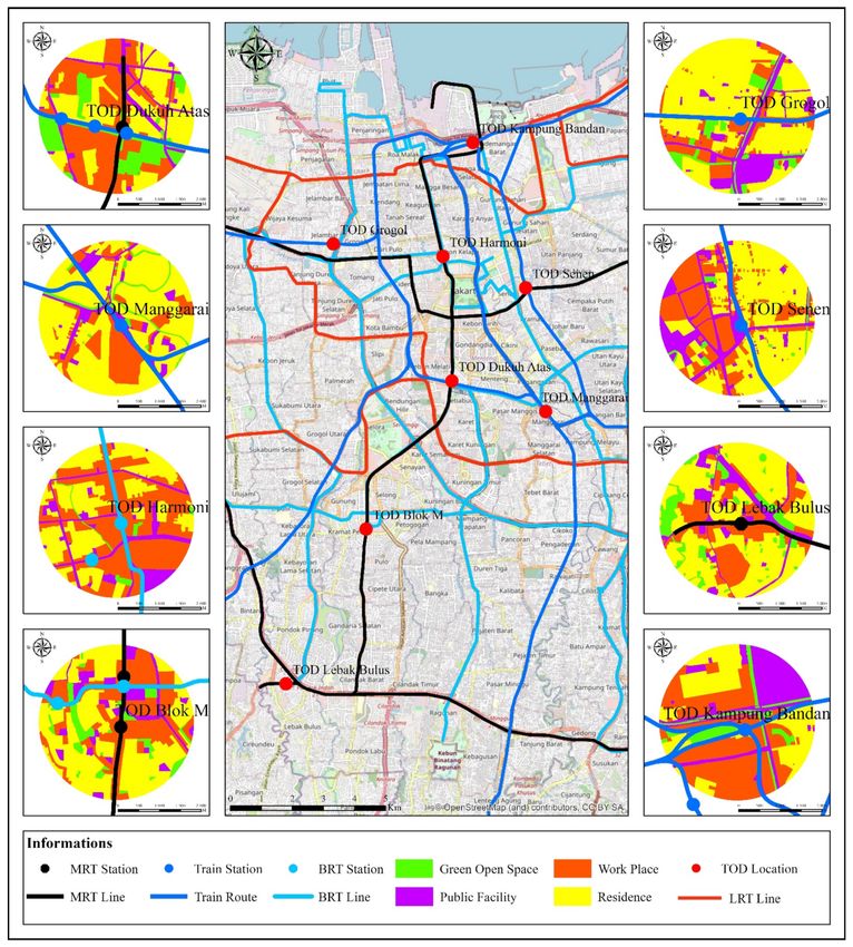
Sustainability 2022, 14, 5244                                                                                               2 of 17

                                transport nodes. Other components are cycling and pedestrian-friendly developments related
                                to accessibility based on infrastructure development [1,10,11]. A Beijing case study identified
                                unique policies and strategies for mixed land use to enhance metro stations’ accessibility [11].
                                In this context, the short distance between metro stations that provides a pedestrian-friendly
                                environment is more important than bus connections [11]. Other studies showed that the TOD
                                infrastructure is expensive, requiring high initial capital investment, with city governments often
                                failing to secure investors [12]. Similarly, operational and maintenance costs are problematic,
                                including financial sustainability only achievable by fulfilling density or maximum ridership [13].
                                Many TOD projects failed to meet their intended objectives [10]. Moreover, there are mixed
                                results regarding implementing the transit-oriented metropolis, the extended version of TOD
                                that clusters the city into adaptive and transit, strong-core, and hybrid [3]. Commuters in South
                                Korea still adopt high mobility, using private automobiles to surrounding areas [14].
                                      Some studies highlighted the relationship between urban spatial land-use develop-
                                ment and travel patterns [15,16], including the impact of land use and income on travel
                                behavior [17–19]. Other studies examined market forces as the dominant factors influ-
                                encing an individual or firm’s decisions when selecting office or home locations [20].
                                Adjusting locations between private housing and employers optimizes travel duration
                                and distance by generating maximum ridership [21]. Furthermore, Ref. [22] highlighted
                                the relationship between land use in areas within a 500 m radius around rail stations and
                                ridership patterns in Seoul. Ref. [23] developed a TOD model to achieve optimal land-use
                                allocation within stations to maximize transit ridership in Jakarta. Similar studies were
                                conducted in metropolitan cities in Japan and China, including Hong Kong, regarding the
                                relationship between property development and the transport rail system [13,24]. Extensive
                                studies in China focused on alternative urban land-use allocations that increase transport
                                ridership [25,26], including using a generic algorithm and the grey linear programming
                                technique [27]. When identifying contributing factors for TOD performance, studies on
                                physical infrastructures with the socio-economic and cultural aspects of the key TOD
                                stakeholder, including the commuters, received scant attention.
                                      The TOD concept has been implemented in many metropolitan cities worldwide [10].
                                However, the concept is relatively new in Indonesia, with limited literature on its policy and
                                implementation. For instance, from the 330 TOD articles reviewed by [10], case studies were
                                drawn from cities in the USA, Europe, Australia, and a few in Asia, including cities in China,
                                Japan, and Thailand. Indonesia’s capital city, Jakarta, the world’s fourth most populous
                                city and South-East Asia’s largest, received no mention. The concept was first included
                                within the policy document enacted in 2012 on the Jakarta 2030 Regional Spatial Plan, also
                                known as Jakarta RTRW 2030. However, the key implementing regulations have only been
                                stipulated since 2017. An efficient transport system and effective urban development are
                                essential to support the Jakarta metropolis with its 29,313,171 people, including 1.2 million
                                commuting daily and population growth of 2–4% [28]. With TOD still in its infancy, a
                                recent study suggested that the government prioritize the diversity of land-use allocation
                                to generate maximum transport ridership [23]. Shortly after 2012 enacted the Jakarta 2030
                                Regional Spatial Plan policy, Ref. [21] assessed the characteristics of the locations proposed
                                as TOD areas through GIS analysis. Additionally, the study examined the relevant factors
                                related to commuters’ socio-economic profiles, mobility, and preference regarding TOD
                                implementation through a survey of 400 respondents. With few exceptions, including [21,23],
                                the existing literature largely focuses on physical factors related to TOD implementation.
                                      The review of 330 TOD projects’ implementation worldwide summarized different
                                impacts on travel behavior, land-use and spatial distribution, real-estate prices, residential
                                location, and community life [10]. TOD debates have shifted from their initial main goal
                                of addressing urban mobility and transportation issues to its impact and physical factors
                                influencing its performance. Although TOD addresses urban transportation issues, the
                                current discussion focuses on making it functional at any cost. The critical question is
                                to whom TOD should be functional. Furthermore, the literature on the relationship be-
Sustainability 2022, 14, 5244 3 of 17
tween land-use development and travel patterns focuses predominantly on travel distance
between housing and work locations, relying on physical infrastructure development.
Moreover, the on-going COVID-19 pandemic has affected travel behavior overall, with
governments worldwide imposing travel restrictions, including a reduction in public trans-
ports’ usage and the closure of public facilities and non-essential retail stores. Policies to
restrict public mobility, such as physical and social distancing and ‘lock down’, are imple-
mented in many countries to mitigate the spread of the virus, and people’s risk perception of
it plays a significant role. A study in China [29] emphasized the critical role of risk perception,
perceived understanding, and safety climate for the successful implementation of social dis-
tancing policies. Relevant to risk perceptions, other studies have highlighted the role of social
media, both positively and negatively, when spreading misinformation [30,31]. A joint force
between governments and scientists from various domains of epidemiology, governance,
economy, and psychology, was called to create potent and persuasive media content for suc-
cessful healthcare protection campaigns [30]. The campaign, which included a ‘stay-at-home’
regime regulating individuals when conducting distance working or studying [30], led to the
transition from working in offices to remote operations.
Many countries have also enacted various public health strategies, including contact
tracing and quarantine, with peoples’ willingness to participate influenced by factors such as
level of knowledge, ethical and psychological aspects that ultimately determine the effective
implementation of the strategies [32]. Another study in Switzerland [33] also identified health
risk perception as an important driver for people’s acceptance of government’s measures for
COVID-19 mitigation. The health risk perception has a mediating effect, which further enhances
public obedience of social distance behaviors. In addition, a China study [34] discussed how
regulatory punishment affects social distancing obedience behavior and could have a greater
effect by enhancing risk perception. While the long-term effect of the COVID-19 pandemic
warrants further research, this present study aims to extend the existing literature by presenting
the preliminary findings of the COVID-19 effects on the changes in commuters’ travel behavior.
Overall, this study contributes to the existing literature by focusing on two TOD impacts,
including changes in commuters’ travel behavior and land-use and spatial distribution [10]
in the Jakarta metropolitan area. It fills a gap in the TOD literature regarding the lack of a
longitudinal study [10]. Furthermore, this study supports [21] with an eight-year lapse since
the inclusion of the TOD concept in 2012 within the Jakarta 2030 Regional Spatial Plan. First, it
aimed to examine the progress and barriers to TOD implementation. Second, this study aimed
to determine changes in commuters’ mobility through a survey of 400 respondents and land-use
spatial distribution via the geographic information system within the several TOD areas in the
Jakarta metropolitan area. It used the 2013 and 2020 data to determine how these changes were
influenced by TOD-related developments. Third, this study aimed to establish appropriate
policy recommendations on how the Jakarta and national governments should pursue TOD or
alternative policies to achieve sustainable urban transportation and development.
2. Materials and Methods
This section outlines the significance of the Jakarta metropolitan area as an important
case study and the methods of data collection and analysis. The methods used include
the geographic information system (GIS) and the survey of 400 daily commuters who live
within the TOD radius area in 2013 as repeated in 2020.
2.1. The Jakarta Metropolitan Area
The Jakarta metropolitan area that includes the cities of Jakarta, Bogor, Depok, Tangerang,
and Bekasi, together known as Jabodetabek, is an important case study for the following
reasons. First, it has the potential to offer a transit-supportive environment covering 5489 km2
and a density of 9756 people per km2 in 2020 [35]. Although residential areas have shifted from
the Jakarta Capital and spread across the suburbs, employment remains concentrated in the
Capital. Second, the TOD concept was included within the 2012 enacted policy document of the
Jakarta 2030 Regional Spatial Plan, but the key implementing regulations were stipulated from
2017 onwards. The slow progress and barriers to TOD implementation necessitate appropriateSustainability 2022, 14, 5244 4 of 17
policy recommendations. Third, Jabodetabek is a metropolitan area with 29.3 million people,
including 1.2 million commuting daily and population growth of 2–4% [28]. This implies the
need for efficient and sustainable transportation and effective urban development. Fourth,
the public transport infrastructure has improved with light rail transit (LRT), rapid mass
transit (MRT), and busway systems. However, their numbers are insignificant compared with
the growth of private motor vehicles of 58,180 annually [28]. Jabodetabek’s administrative
territories include Jakarta province, Bogor city and district, Bekasi city and district, Tangerang
city, South Tangerang city, and Tangerang district. These territories hold significant relevance,
as they were included within the initial TOD plan incorporated within the Jakarta 2030 Regional
Spatial Plan. They are also relevant to the rail network development plan, a policy established
by the national government through the Ministry of Transport and Network.
Daily commuters in Jabodetabek increased tenfold between 1985 and 2002 [36], 1.5-fold
from 743 thousand trips in 2000 to 1.1 million in 2010 [37], and grew to 1.38 million trips in
2014 [38]. In 2019, daily commuters decreased to 1.2 million trips [28]. About 80% of the
trips in 2014 were made by private vehicles [21], reducing to 66% in 2019 [39].
Jakarta is Indonesia’s first province to include a TOD concept within its Regional Spa-
tial Plan 2030 issued in 2012. Its implementation has been slow and uncertain, challenged by
barriers, such as overlapping institutional infrastructures. One implementing regulation is
the Spatial Plan and Zoning issued in 2014 [40]. Other policy documents include Governor
Regulations number 44 of 2017 on the Development of TOD replaced by number 67 of 2019,
and number 140 of 2017 on the Assignment of the MRT Jakarta Corporation to manage
the first phase of the MRT operation, the TOD North–South corridor [41]. Furthermore,
Presidential Regulation number 55 of 2018 on the Greater Jakarta Transportation Master
Plan [42] was issued to regulate TOD implementation in the Jabodetabek area. Although
there is convergence between policies issued by the Jakarta provincial, Jakarta metropolitan,
and national governments, several differences exist regarding selecting TOD areas [40,42].
2.2. Geographic Information System (GIS) and Analysis of Land-Use Changes
Land-use maps were constructed according to the basic land-surface map developed
by the National Agency of Land Survey. These maps were analyzed using the ArcGIS
system of 2013 and 2020 and data from field surveys. The land-use structure and spatial
growth analysis included the growth or expansion of urban forms, density, diversity or
heterogeneity, and connectivity [43,44]. Moreover, this study utilized Google Earth satellite
imagery to construct the relevant land-use maps of 2013 and 2020 for the Jakarta region. It
examined land-use changes between 2013 and 2020 through the following steps.
This study conducted spatial digitization involving data processing from satellite imagery
into vector data using ArcGIS 10.1 version. The categorical maps of the urban green space were
manually interpreted based on the same ArcGIS 10.1. The same image or spatial interpretation
was then conducted to classify land use following the National Agency of Land Survey’s
classification comprising residential areas, workplaces, public facilities, and green open space.
Following the GIS results of the land-use maps, this study used the non-site-specific-
accuracy method [45] to calculate the total area assigned to each land-use category and
compare the changes between 2013 and 2020. It compared the overall figures with the size
and distribution of land use of the categories. Since both maps use the same classification
scheme, they were classified at the same level of detail.
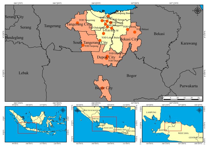
The location areas are the planned and considered as TOD areas in Jabodetabek, eight
areas in Jakarta city and six in the suburbs (Figure 1). The selected TOD areas within
Jakarta capital are grouped into three categories: (1) those that are MRT based consist of
Dukuh Atas, Lebak Bulus, and Kampung Bandan; (2) those that are commuter rail based
consist of Manggarai and Senen, and (3) those that are BRT based include Harmoni, Blok
M, and Grogol. The six studied areas within the suburbs have not received formal TOD
interventions and still operate as ordinary transit areas (Figure 1). The other TOD areas
depicted in Figure 1, including Bogor, Depok, Depok Baru, Tangerang, Tangerang Selatan,
and Bekasi, are the main railway networks where commuters begin their departure from
each of the suburbs to Jakarta capital as the main destination.Sustainability 2022, 14, 5244 5 of 17
Figure 1. Map of the Jakarta metropolitan area (Jabodetabek) and the main TOD areas.Sustainability 2022, 14, 5244 6 of 17
Eight TOD areas were selected as samples for the following reasons. Six of them,
i.e., Dukuh Atas, Manggarai, Harmoni, Senen, Blok M, and Grogol were included within
the 2030 Jakarta Regional Spatial Plan. The other two areas, Lebak Bulus and Kampung
Bandan, were specifically planned as TOD-based MRT Stations (Figure 2).
Figure 2. Eight TOD main areas in Jakarta city, a GIS-based land use map of 2020.
Following [44], this study employed a spatial unit of analysis of 1 km radius of the
TOD area. It adopted the following formula to measure land-use diversity.
n
ln(i )
LUDI = − ∑ li. (1)
i =1
ln(4)
The formula is explained as follows:
• LUDI (land use diversity index): this is an index used for representing the land-use
mix or homogeneity rate of land use in a given area.
• li: the ratio of a particular area of the land-use category to the total area being analyzed.
• li multiplied with the (ln i) which is divided by the total area (ln 4) within the TOD
area with four land-use categories.
Since LUDI is normalized using the natural logarithm of the number of land uses,
its value lies between 0 and 1, where 0 represents homogenous land use, and 1 indicates
the tract of land that is equally distributed across all land use types. A higher diversity
index implies many diverse activities within the proximity of TOD areas. This reflects
the population’s mixed socio-economic condition and better synergies between various
land-use functions.
2.3. Survey of 400 Daily Commuters Who Live in Planned TOD Areas in 2013 and Repeated
in 2020
Each of the 2013 and 2020 surveys involved 400 daily commuters, who live in planned
TOD areas, moving from Bogor, Depok, Tangerang, Bekasi (Bodetabek) to the Jakarta capitalSustainability 2022, 14, 5244 7 of 17
city mainly for work reasons. The 2013 survey was conducted after the TOD concept was
included within the 2012 policy document of the 2030 Jakarta Regional Spatial Plan. In both
surveys, 400 respondents were selected randomly from the transit areas within the six rail
stations in suburban areas (Bogor station, Depok station, Depok Baru station, Tangerang
station, South_Tangerang station, and Bekasi station). Furthermore, 50 respondents were
added in 2020 from the newly operated Lebak bulus MRT station (Figure 2). The 400 people
surveyed in the eight TOD areas studies were purposely selected to meet two criteria:
(1) worker/employee, and (2) commuter who lives within a radius of 1 km of a TOD area
and works in the Jakarta capital. The population (i.e., number of employees) in aggregate
was 4.047 in 2013 and 4.582 people in 2020, hence the number of surveyed people reached
9.8% and 8.7% of the population, respectively.
The 2020 survey was conducted in August to examine changes in commuters’ travel
behavior and their preferences relating to TOD implementation. The main 2013 survey
questions were used in data collection. Information was collected on commuters’ geo-
graphic origins, including distance to the transit locations, residential status, length of
residency, reasons to select residences, and access to transit locations. Furthermore, the
survey focused on the purpose of their mobility and the spatial distribution of workplaces
and distance. The commuters’ mobility, including modes of transport, frequency of trips,
average commuting time, travel cost, fuel consumption, and total time of return travel, were
also surveyed. Additionally, data were collected on their TOD implementation understand-
ing and preferences for the design and rationale of residence selection. The 2020 survey
included a question on commuters’ preference to work from home due to the COVID-19
pandemic which has influenced their travel behavior. The limitation of this research design
was the respondents asked in 2013 were not same as the respondents in 2020, although the
residents are in the same area within TOD area.
3. Results
3.1. The Changes of Land-Use and Spatial Distribution within TOD Areas between 2013 and 2020
Land-use changes within a one-kilometer radius of TOD areas between 2013 and 2020
are outlined in Tables 1 and 2. In Table 1, the changes within the eight TOD areas in Jakarta
city are less significant than in suburban areas (Table 2).
Table 1. Land use diversity index in a radius of 1 km of TOD areas in Jakarta capital city.
Residential (%) Work Places (%) Public Facilities (%) Green Open Spaces (%) Diversity Index
TOD Areas
2013 2020 2013 2020 2013 2020 2013 2020 2013 2020
Dukuh Atas 36.79 35.48 36.17 36.91 5.09 11.54 21.95 16.06 0.88 0.92
Manggarai 60.15 65.64 27.85 18.91 5.78 11.61 6.22 3.83 0.72 0.70
Harmoni 18.66 33.91 66.05 48.84 5.49 15.59 9.79 1.65 0.70 0.77
Blok M 43.97 46.39 31.40 33.18 14.80 13.49 9.74 6.94 0.89 0.85
Grogol 55.04 60.44 21.18 15.66 11.41 16.36 12.38 7.53 0.84 0.78
Senen 51.36 50.46 28.28 29.46 17.55 18.40 2.81 1.68 0.80 0.78
Lebak Bulus 53.09 53.50 18.80 23.49 15.66 13.05 12.45 9.95 0.87 0.84
Kampung Bandan 25.44 25.43 45.33 42.41 12.08 23.44 17.14 8.72 0.91 0.91
Table 2. Land use diversity index within a radius of 1 km of TOD areas in suburban Bodetabek.
Residential (%) Work Places (%) Public Facilities (%) Green Open Spaces (%) Diversity Index
TOD Areas
2013 2020 2013 2020 2013 2020 2013 2020 2013 2020
Bogor 50.76 48.80 31.14 17.83 3.45 20.17 14.64 13.20 0.80 0.90
Depok 78.09 67.09 8.10 11.88 3.24 7.39 10.57 13.65 0.54 0.71
Depok Baru 65.15 65.76 15.01 15.26 2.46 7.94 17.15 11.04 0.69 0.73
Tangerang 61.66 57.97 18.26 14.44 8.60 15.84 11.48 11.75 0.77 0.82
Tang-Sel 75.35 66.26 2.68 4.37 2.47 5.36 19.51 24.01 0.52 0.66
Bekasi 57.83 39.14 13.97 23.70 8.78 15.07 19.43 22.09 0.81 0.96Sustainability 2022, 14, 5244 8 of 17
The comparison of the diversity variable in Jakarta between 2013 and 2020 showed
that the TOD residential areas grew significantly (Table 1). The growth was almost twofold
in the Harmoni area that hosts the central station of the Trans-Jakarta busway system.
Moreover, there was a diversity of around 3–5% within TOD areas, such as Manggarai, Blok
M, and Grogol. A decrease in diversity occurred only in the Senen area, and no changes
were recorded in the Lebak Bulus and Kampung Bandang areas. Workplaces showed a
decrease within all TOD areas, except Blok M, Lebak Bulus, and Senen. Lebak Bulus hosts
the new MRT station, showing the highest increase in the workplace category. Furthermore,
a significant increase occurred in public facilities within six TOD areas and a decrease in
Blok M and Lebak Bulus. The green open space function decreased in all areas.
The changes in public facilities areas are insignificant in Dukuh Atas, Manggarai,
Harmoni, and Kampung Bandan at the expense of green open space (Table 1). This could
be attributed to the government enlarging the station areas and supporting facilities in
the initial TOD development. Based on the diversity index values, only Dukuh Atas and
Harmoni had an increase in the diversity of land use. Dukuh Atas is a central hub of
transportation modes, including the MRT, BRT, rail commuter, and airport rail, and has a
high diversity index of 0.92. Harmoni, the central hub of BRT, has a moderate diversity
index of 0.77. These two central transit hubs experienced an increase in the diversity index.
Therefore, the other six sampled areas failed to achieve TOD’s criteria of land-use diversity.
Figure 2 shows the comparison of the diversity variable in four large-scale TOD areas
in Jakarta city in 2020. It shows that residential areas dominate in Lebak Bulus with 52%
followed by workplaces with 23%, public facilities with 13%, and green open spaces with
9.95%. Residential areas and workplaces hold similar proportions in Dukuh Atas, the
central hub of Jakarta’s major land transportation. In Harmoni and Blok M areas, the BRT
large-scale TOD regions, residential areas, and workplaces are similar, with the previous
functional area experiencing a significant decrease in its green open space.
The GIS-based analysis of land-use changes between 2013 and 2020 showed a large
difference in the diversity of the planned TOD areas between those in sub-urban Bodetabek
and those in Jakarta. Most locations in sub-urban Bodetabek experienced a decrease in
residential built areas but an increase in workplaces (Table 2). There was a notable increase
in workplaces in Depok, South Tangerang, and Bekasi directly connected to Jakarta through
the mass transport system (Table 2). This could be attributed to the private sector’s decision
to choose the suburbs as an affordable location for their business activities. In this case, the
accessibility variable to the Jakarta central business district is no longer an issue.
Moreover, Table 2 shows that public facilities grew significantly in all planned TOD
areas within the suburbs in the eight-year lapse. Although green open spaces decreased
in Jakarta (Table 1), they increased in some major Bodetabek’s TOD areas, such as Depok,
South Tangerang, and Bekasi (Table 2). All TOD areas have higher land-use diversity to
suit TOD criteria based on the diversity index.
3.2. Housework: Changes in Commuters’ Preference between 2013 and 2020
The survey results (Table 3) indicate that accessibility contributed most to commuters’
reasons to choose housing locations in the east and west suburbs in 2013. In contrast,
most commuters selected the south suburbs due to social factors, including geographical
proximity with extended family members and kinship relations. There are significant
differences in commuters’ preferences between those from the east and west suburbs with
others in the south suburbs. Accessibility, price, and social factors became the three highest
priorities in east and west suburbs. However, south suburbs’ commuters cited the social,
green open space, and price factors. In 2020, accessibility, social, and price factors remained
the three of the most cited preferences. The green open space was the least and most cited
factor in 2013 and 2020, respectively, and is even higher than the public and water facility
factors. Another notable finding was the factor related to the new development of the
MRT, where the near MRT station factor was the least cited. The south suburb’s commuters
mostly considered the social factor in choosing house locations in 2013 and 2020. The eastSustainability 2022, 14, 5244 9 of 17
suburb’s commuters consistently cited accessibility as the most important factor, while the
west suburbs changed preferences from accessibility in 2013 to the price factor in 2020.
Table 3. Commuters’ preference in choosing housing location in Jakarta suburbs (in percentage (%)).
2013 2020
Influencing Factors East Suburbs West Suburbs South Suburbs East Suburbs West Suburbs South Suburbs
GOS 7.50 7.60 19.30 16.60 17.40 20.20
Social (kinship) 19.60 19.60 20.10 24.80 17.20 24.90
Accessibility 24.60 24.60 18.30 25.30 24.20 24.70
Price 21.00 21.00 19.70 21.40 24.30 21.80
Public Facility 15.80 15.80 11.00 13.60 20.70 12.30
Water Facility 11.50 11.50 11.70 11.20 13.60 10.20
Near The MRT 3.70 0.00 6.10
Note: GOS: Green open space.
Furthermore, Table 4 highlights commuters’ reasons to select workplace locations in
2020. It shows whether their decisions were influenced by the newly developed transport
infrastructures, such as MRT, LRT, better access to the transit stations of the Trans-Jakarta
bus system, or geographic proximity of transport lines to workplaces. Commuters from
all suburbs predominantly considered the place of employer factor as the main reason to
choose the workplace location. The second reason by commuters from the east and west
suburbs was near commuter line KRL, an electricity-based mass train. Almost the same
percentage was revealed by commuters from the South suburbs. A notable finding was the
factor of near MRT or LRT being the least cited reason.
Table 4. Commuters’ reasons to choose workplace locations in Jakarta capital city.
Reasons to Choose Workplace Locations 2020 in Percentage (%)
Commuters’ Origin (Bodetabek
Areas and Jakarta Suburbs) Easy Access to
Near CL Near MRT/LRT Place of Employers Others
Trans-Jakarta Bus
- East Suburb of Jakarta
(Bekasi city and Bekasi 19.3 1.8 0.9 78.9 1.8
residency)
- West Suburb of Jakarta
(Tangerang city, South
20.9 7.5 0.0 71.6 0.0
Tangerang, and Tangerang
residency)
- South-Suburb of Jakarta
(Depok city, Bogor city, and 21.7 0.0 1.6 54.3 22.5
Bogor residency)
Notes: CL: commuter line; MRT: mass rapid transit; LRT: light rapid transit.
3.3. Changes in Commuters’ Travel Behavior between 2013 and 2020
The main modes of public transportation cited (Table 5) included train, regular bus,
BRT Trans-Jakarta bus, and City minibus, known locally as angkot. The 2020 survey included
MRT, which became operational in March 2019. The findings in Table 6 show that the
commuters’ main concern is the availability of a reliable public transport system and not
the distance between their residential and workplace locations. The current KRL commuter
lines play a key mobility role in the Jakarta Metropolis, with a stable growth rate of more
than 50% in 2013 and 70% in 2020. Consequently, 57% of commuters from East suburbs
consistently use this transportation mode (Table 5). Moreover, Table 5 shows that there is a
significant increase in the use of the BRT Trans-Jakarta bus, from 0.6% in 2013 to 10.5% in
2020. A significant change occurred in the travel mode of west suburb commuters, where
the use of KRL commuter lines increased from 8.3% in 2013 to 72.4% in 2020. There wasSustainability 2022, 14, 5244 10 of 17
a 1.5% usage of the MRT and a decrease in using the regular bus and city minibus. Most
BRT Trans-Jakarta corridors connect all Jakarta city and suburban areas. The use of MRT by
the east suburb’s commuters is low, while the south suburbs’ commuters hold the highest
usage with 14%. Furthermore, KRL commuter lines and BRT usage increased to 4.9% and
4.7%, respectively. The usage of the mass transit system, including the KRL commuter lines,
BRT, and MRT, increased significantly between 2013 and 2020.
Table 5. Shared modes of public and private transportations within TOD areas in Jakarta suburbs.
Public Transportation Usage
2013 2020
Commuters’ Origin KRL KRL
BRT Trans- City Mini BRT Trans- City Mini
Commuter Bus Commuter Bus MRT
Jakarta Bus Jakarta Bus
Lines Lines
East suburbs of Jakarta 57.1 5.2 0.6 13.0 57.9 3.5 10.5 0.0 0.9
West suburbs of Jakarta 8.3 21.4 6.5 11.7 72.4 0.0 7.5 1.5 1.5
South suburbs of
54 10.0 0.0 5.0 58.9 0.0 4.7 0.8 14.0
Jakarta
Private Transportation Usage
2013 2020
Car Motorbike Bicycle Car Motorbike Bicycle
East suburbs of Jakarta 5.2 29.9 1.3 19.3 43.0 0.0
West suburbs of Jakarta 10.2 28.9 0.0 5.2 69.4 1.5
South suburbs of
17.5 0.0 0.0 16.3 50.4 0.8
Jakarta
Notes: KRL: ‘Kereta Rel Listrik’, i.e., an electricity-based mass train, also known as ‘commuter line’. MRT: mass
rapid transit; LRT: light rapid transit; BRT: bus rapid transit.
Table 6. Reasons to use public transport by commuters within TOD areas in suburbs.
Reasons to Use Public Transport (In Percentage (%))
Suburbs New Transport Better Connectivity of
Pedestrian Space Cost
Infrastructure (MRT, LRT) Trans-Jakarta Bus
East suburbs of Jakarta 9.6 11.4 0.0 31.6
West suburbs of Jakarta 23.9 22.4 1.5 29.1
South suburbs of Jakarta 38.0 16.3 8.5 31.0
As shown in Table 5, there is a significant shift in commuters’ using private vehicles
from all the departure points, with a sharp increase in motorcycle usage. Moreover,
commuters rarely use bicycles, which are non-existent at some departure points. The east
suburbs commuters’ use of private cars and motorcycles increased about fourfold and
twofold in 2020, respectively. In the west suburbs, the usage of cars decreased almost half,
from 10.2% to 5.2%. However, the use of motorcycles increased nearly two and a half fold,
and bicycle usage, a new phenomenon, increased by 1.5%. Furthermore, the south suburbs’
usage of motorcycles surged from 0% in 2013 to 50.4% in 2020. The speed factor explains
why private vehicle usage is still dominated by motorcycles, which is because they navigate
severe traffic congestion efficiently.
The respondents were also asked whether their reasons for using public transport
were influenced by the newly developed transport infrastructures such as MRT and LRT
(Table 6). They were also asked whether their reasons were influenced by other mass transit
systems, such as the BRT Trans-Jakarta bus or the development of more pedestrian spaces.
As shown in Table 6, the MRT and LRT infrastructure has the most significant impact
on commuters from the south suburbs deciding their public transport use. The reason
for this could be that the first operated line of the MRT service is through the south
suburbs. Moreover, the better-connected Trans-Jakarta bus and newly operated MRT
impacted the decision of the west suburbs’ commuters. The most important reason forSustainability 2022, 14, 5244 11 of 17
using public transport is the cost, except for the south suburban commuters. New transport
infrastructure and cost were cited almost equally in the south suburbs, with 38% and
31%, respectively. Other main decision-making factors when using public transport is
the improvement in connectivity of the Trans-Jakarta bus. Although the LRT was built
in the east part of Jakarta, it is not preferred by commuters because of its high cost. As
for walking, this study found that commuters preferred not to walk between the point
of origin to transit stations or from the stations to the destination. More than 50% of the
commuters traveled to the stations, not by foot. Overall, the cost factor is the one of the
dominant reasons to use public transportation (Table 6).
3.4. Changes in Commuters’ Travel Behavior Impacted COVID-19
Survey results (Table 7) showed that commuters, predominantly from the east and
south suburbs of Jakarta, were largely unaffected by the COVID-19 pandemic-related
measures. They still used the trains from the transit stations to work places. Different
results were observed in the west suburbs, where the majority of commuters changed their
mode of transport, no longer using trains (Table 7). Noticeably, commuters also tended
not to change their pattern of accessing the station, i.e., the way they travel from home to
the transit stations during the pandemic. This can be attributed to two factors: the limited
choice of modes of transport offered in transit stations, and the unavailability of alternative
modes that connect the stations to their residence. These are classic factors that occur in
many transit stations that are still in the early development stage, especially when the
supporting infrastructure is still not fully prepared, as advocated by the TOD concept.
Table 7. Change of travel behavior influenced by COVID-19 (in percentage (%)).
Item/Sub-Urbs No Yes No Answer
Use of train from the station
East suburbs of Jakarta 48.4 51.6 0
West suburbs of Jakarta 72.0 28.0 0
South suburbs of Jakarta 37.0 63.0 0
Changes in traveling time and frequency
East suburbs of Jakarta 46.5 53.5 0
West suburbs of Jakarta 25.0 63.0 12
South suburbs of Jakarta 71.0 27.0 2.0
Changes in mobility due to service limitations
East suburbs of Jakarta 26.8 66.8 6.4
West suburbs of Jakarta 34.0 43.0 22.0
South suburbs of Jakarta 20.0 58.0 2.0
With regard to the survey question on changes in traveling time and frequency of
traveling, the survey results (Table 7) showed that most of the commuters reduced their
daily commuting time during the pandemic. They tended to focus only on essential
travel, such as commuting to the work places, where many employers operated shift work,
and buying essentials or acquiring basic services, including education and health. An
interesting finding is that commuters from the south suburbs predominantly showed no
changes in traveling time and frequency, also tending to maintain the use of trains as their
preferred mode of transportation to their workplace and other destinations. Relating to
travel limitations imposed during the pandemic, most commuters showed changes in their
mobility behaviors. The commuters from all transit stations were more careful in avoiding
rush hours, which are usually crowded with passengers, and switched their travel to non-
peak hours. Thus, they could still travel but avoid crowded situations and long queues
which could pose dangerous health risks during the pandemic.Sustainability 2022, 14, 5244 12 of 17
4. Discussion
4.1. The Changes of Land-Use and Spatial Distribution
Research results showed that the increase in the residential function around TOD
areas in Jakarta was evident, although the suburbs experienced a decrease (Table 1). This
suggests an improved readiness and interest of commuter around TOD areas in 2020, eight
years after the concept was included within Jakarta’s spatial planning policy document in
2012. Moreover, the increase in the number of commuters from the south suburbs who
gave greater transportation access to TOD areas in the capital city suggests that TOD areas
have become a more desirable location for workplaces.
Following our findings, Jakarta Metropolis’s governments and urban planners need
to improve policies that enable residential and working places around TOD areas with
high connectivity and accessibility to public transportation. The aim of moving commuters
closer to workplaces is to decrease their mobility, travel distances, and usage of private
vehicles. This policy was usually advocated based on the argument that placing residen-
tial and workplaces around TOD areas significantly enhances the land-use density and
diversity [43,46–48]. However, governments should cautiously adopt this strategy and
learn from other TOD implementations that failed to attract enough people to reside within
TOD areas, including cases in Thailand [49,50]. In Thailand’s case, the TOD areas were
deserted by native residents because they could not afford the housing prices that had
increased drastically since the development of infrastructure [48,50]. Furthermore, local
authorities failed to attract new residents to move to the TOD areas for the same reason [50].
Studies worldwide suggest that local governments could not establish affordable housing
due to the sharp rise in land price within TOD areas [10,51,52]. In contrast, the TOD concept
succeeded in Shenzen, China, partly due to establishing government-subsidized rental
housing [52].
Another notable finding from our study (Table 1) shows a significant increase in public
facilities at the expense of green open space (GOS) in the capital city. Most of the capital’s
land is owned by the National or Jakarta government and has been used by previous
development projects [53]. Therefore, relevant government authorities must utilize GOS to
develop the required public facilities within the transport systems, including stations and
pedestrian spaces. For almost a decade, TOD has been implemented solely by governments’
legal authorization to manage GOS. Therefore, governments should engage the private
sector through a public–private TOD partnership (PPP) to address this limitation [54].
4.2. The Change of Commuters’ Preference to Choose Workplace and Housing Locations
The TOD components of land-use diversity and destination accessibility were con-
sidered to be more significant than others by commuters. Commuters from all suburbs
predominantly considered the place of employer factor as the main reason to choose
the workplace location. Our finding differs from other studies which showed that re-
gional accessibility influenced travelers’ behavior as an important predictor of rail station
ridership [55].
This finding informs relevant policymakers and urban planners to focus on the en-
hancement of the accessibility of workplace and housing locations as part of their TOD
strategic implementation. Previous TOD studies recommended the universal increase in
land-use density and diversity around transit stations [43,46]. However, our study found
other factors critical to TOD implementation. These are socio-economic and cultural as-
pects, including commuters’ customs and practices, which should be accounted for when
governments implement TOD. For instance, commuters’ preference for housing location
was also significantly influenced by kinship relations or the social factor (Table 3), reflecting
the local culture. Commuters live near their families and relatives, who provide child care
and livelihood support. Other social factor variables include the feeling of security and
belonging as discussed by van Gent et al. [56].
The existence of new transport infrastructures, such as MRT and LRT, did not sig-
nificantly influence commuters’ choice of workplace (Table 4). This means that ridershipSustainability 2022, 14, 5244 13 of 17
should be increased to achieve a sustainable transport system. As advocated across the
TOD literature, transit ridership could be enhanced by improving multi-modal connec-
tions and planning land use that attracts travelers and serves as a destination in chained
trips [57]. Although feasible, these strategies depend largely on the expensive development
or expansion of physical transport infrastructures, such as MRT and LRT. City governments
often cite financial barriers as the main challenge to implementing TOD [58]. Another
notable finding of our study is with regard to commuters’ preference in choosing housing
locations influenced predominantly by kinship relations (Table 3), that reflects the local
culture of living in close proximity to family and relatives.
4.3. The Change of Commuters’ Travel Behavior
One of our key findings is related to the existence of new transport infrastructure, such
as MRT and LRT, which did not significantly influence the use of public transportation by
the majority of commuters, although it impacted the travel behavior of the south suburbs’
commuters (Table 6). The better connectivity of the Trans-Jakarta bus also has more impact
to endorse the commuter to use public transportation. These findings also suggest that
increased ridership of existing transport systems may hold greater prospects for success
for achieving a sustainable transport system, compared to building new transport systems
which commuters cannot afford. This relates to another key finding for which “travel
cost” was cited as one of the most important factors when using public transport. For
example, while LRT has been built and is operational in eastern Jakarta, it is considered
expensive and, thus, not preferred by commuters, costing twice that of the Trans-Jakarta
bus and thrice the commuter rail [59]. This finding resonates with an earlier study in Beijing
which highlighted time punctuality, affordable cost, and comfortable experience as factors
attributing to the commuters’ subjective experience toward traffic congestion and which
ultimately influenced their travel behavior [60].
Pedestrian-friendly spaces, a key characteristic of TOD, have less impact on commuters’
decision to use public transportation (Table 6). This finding differs from those in other large
cities, such as Seoul, where walking and bicycling are prominent modes of transport [57].
However, a positive link exists between MRT availability and pedestrian space in the
south suburbs. Commuters’ walking behavior has increased significantly within the south
suburbs and decreased in the other two suburbs (Table 6).
Walking is one of TOD’s primary goals as part of integrating land-use and transport
development [43,44,46]. However, pedestrian space would only be an influencing factor
with an integrated transport infrastructure network. This finding differs from the com-
monly advocated TOD concept. Based on TOD, a pedestrian-friendly design, including
the threshold distance to transit stations and walking destination, promotes pedestrian
mobility and increases transport ridership [61]. Indonesians’ walking habit is low, with
the country being placed last out of 46 countries and territories for the number of citizens
walking steps [61]. A pedestrian-friendly infrastructure is considered a key factor in en-
hancing walking behavior. However, the online motorcycle taxi, known locally as Gojek,
has discouraged the walking habit, with commuters using it instead of walking to and from
transit stations, this in line with [62].
While the COVID-19 pandemic and mobility restrictions have changed human mo-
bility, in general, our finding suggests that the pandemic has not significantly impacted
commuters’ travel behavior in our study areas. Differing from China as the first country
that implemented a national lockdown [29], Indonesia, including the Jakarta metropolitan,
did not implement a lockdown policy. Instead, certain mobility restrictions were imposed
when cases of COVID-19 increased severely. In our study areas, through governments’
regulations on mobility restrictions, the changes in commuters’ travel behavior varied.
In many transit stations, commuters did not voluntarily change their preferred modes of
transportation during the restriction periods, still relying on ordinary trains to serve their
mobility. As discussed earlier, this can be attributed to the lack of alternative modes of
public transport meeting commuters’ main considerations, i.e., price affordability. Nonethe-Sustainability 2022, 14, 5244 14 of 17
less, whilst the commuters’ willingness to comply with the local authority’s public health
strategies during the pandemic was not as full as expected, there was evidence of travel
behavioral changes with regard to travel time and frequency.
Further research needs to be conducted following the post-pandemic phenomenon
and related policies. Specifically following [31], future research in the Jakarta metropolitan
area needs to focus on attributing factors that may influence people’s willingness to comply
with public health strategies, including ethical, psychological, and practical factors that
were deemed to be important and frequently discussed within the existing literature [31].
Moreover, as highlighted by other studies [29,30,33], the following key interrelating factors
also warrant study in the Jakarta metropolitan area: how public guidance influences the
risk perception of individuals, the role of social media in shaping such risk perception,
and the extent to which risk perception and regulation punishment affect social distancing
obedience behavior.
5. Conclusions
• Through a geospatial information system analysis and survey of 400 daily commuters
who live within a 1 km radius of the planned TOD case study areas conducted in
2013 and 2020, our study examined changes in the spatial distribution of land use and
commuters’ travel behavior, determining the extent to which TOD implementation
influenced these changes, thereby informing appropriate future policies. While ac-
knowledging the importance of land-use diversity and accessibility within the modes
of transit transportation, i.e., the physical aspect of which has become a major focus
of the existing TOD literature, our research findings revealed a significant weight on
social and culture as key factors that influenced commuters’ travel behavior, with
kinship relations being the main reason for choosing housing locations.
• A significant increase in public facilities at the expense of green open space (GOS)
indicates that TOD implementation was conducted by the government with the sole
authority to manage GOS, lacking private sector involvement.
• Our study found workplace and home culture as key factors for commuters’ decisions
to support TOD implementation, highlighting socio-cultural elements as key deter-
mining factors toward achieving sustainable urban transportation and development.
The cost factor was the commuters’ main reason for using public or private modes
of transportation, reflecting specific mobility habits and local culture. Therefore, we
call for policymakers and urban planners to consider these aspects when designing
transit areas and enhancing accessibility to commuters’ housing locations and work-
places. Specifically, the workplace is important because commuters cannot change
employment easily.
• We also found that the COVID-19 pandemic has not caused significant change in
the mobility behavior pattern of commuters who live within planned TOD areas
in the Jakarta Metropolitan areas. This is attributed to the factor that commuters’
ability to change employment is limited. Following our research findings, our policy
recommendations comprise two aspects on which governments should focus: (1)
improving public transportation modes which are affordable, and (2) establishing
good access and connectivity between housing and workplaces.
• There are several key limitations of this study, and we recommend that future research
pays particular attention toward addressing them. Firstly, our sampled population
consisted of commuters who live within a 1 km radius of the planned TOD areas. Thus,
they may not have all the attributes that comprehensively match with the characteris-
tics of the overall commuting population. Secondly, we surveyed different individuals
as research respondents between 2013 and 2020. Therefore, the survey results might
not prove the relationships and consistencies of the same commuters. Moreover, future
research is required to include workers whose workplaces are within those planned
TOD areas to explore their dominant travel behaviors and the relationship between
the points of origin and destination within TOD areas.Sustainability 2022, 14, 5244 15 of 17
Author Contributions: Conceptualization, H.S.H. and M.M.; methodology, H.S.H.; formal analysis,
H.S.H.; investigation, H.S.H.; resources, H.S.H.; data curation, H.S.H.; writing—original draft prepa-
ration, H.S.H.; writing—review and editing, M.M.; visualization, H.S.H.; supervision, M.M.; project
administration, M.M.; funding acquisition, M.M. All authors have read and agreed to the published
version of the manuscript.
Funding: This research was funded by Research and Development Division Universitas Indonesia,
grant number NKB-1455/UN2.RST/HKP.05.00/2020.
Institutional Review Board Statement: Not applicable.
Informed Consent Statement: Not applicable.
Data Availability Statement: The data presented in this study are available on request from the
corresponding author.
Conflicts of Interest: The authors declare no conflict of interest.
References
1. Abdi, M.H.; Lamíquiz-Daudén, P.J. Transit-oriented development in developing countries: A qualitative meta-synthesis of its
policy, planning and implementation challenges. Int. J. Sustain. Transp. 2020, 16, 195–221. [CrossRef]
2. Thomas, R.; Bertolini, L. Defining critical success factors in TOD implementation using rough set analysis. J. Transp. Land Use
2017, 10, 139–154. [CrossRef]
3. Cervero, R. The Transit Metropolis: A Global Inquiry; Island Press: Washington, DC, USA, 1998.
4. Loukaitou-Sideris, A. Transit-Oriented Development in the Inner City: A Delphi Survey. J. Public Transp. 2001, 3, 75–98. [CrossRef]
5. Ewing, R.; Cervero, R. Travel and the Built Environment. J. Am. Plan. Assoc. 2010, 76, 265–294. [CrossRef]
6. Curtis, C.; Scheurer, J. Planning for sustainable accessibility: Developing tools to aid discussion and decision-making. Prog. Plan.
2010, 74, 53–106. [CrossRef]
7. Handy, S.L. Accessibility- vs. Mobility-Enhancing Strategies for Addressing Automobile Dependence in the U.S.; University of California
at Davis Recent Work: Davis, CA, USA, 2002.
8. Papa, E.; Bertolini, L. Accessibility and Transit-Oriented Development in European metropolitan areas. J. Transp. Geogr. 2015, 47,
70–83. [CrossRef]
9. Gu, P.; He, D.; Chen, Y.; Christopher Zegras, P.; Jiang, Y. Transit-oriented development and air quality in Chinese cities: A
city-level examination. Transp. Res. Part D Transp. Environ. 2019, 68, 10–25. [CrossRef]
10. Ibraeva, A.; de Correia, G.H.A.; Silva, C.; Antunes, A.P. Transit-oriented development: A review of research achievements and
challenges. Transp. Res. Part A Policy Pract. 2020, 132, 110–130. [CrossRef]
11. Lyu, G.; Bertolini, L.; Pfeffer, K. How does transit-oriented development contribute to station area accessibility? A study in Beijing.
Int. J. Sustain. Transp. 2020, 14, 533–543. [CrossRef]
12. Wang, J.; Samsura, D.A.A.; van der Krabben, E. Institutional barriers to financing transit-oriented development in China:
Analyzing informal land value capture strategies. Transp. Policy 2019, 82, 1–10. [CrossRef]
13. Suzuki, H.; Murakami, J.; Hong, Y.-H.; Tamayose, B. Financing Transit-Oriented Development with Land Values: Adapting Land Value
Capture in Developing Countries; World Bank Publications: Washington, DC, USA, 2015.
14. Vongpraseuth, T.; Seong, E.Y.; Shin, S.; Kim, S.H.; Choi, C.G. Hope and reality of new towns under greenbelt regulation: The case
of self-containment or transit-oriented metropolises of the first-generation new towns in the Seoul Metropolitan Area, South
Korea. Cities 2020, 102, 102699. [CrossRef]
15. Dargay, J.; Hanly, M. The impact of land use patterns on travel behaviour. In Proceedings of the European Transport Conference
(Etc), Strasbourg, France, 8–10 October 2003; p. 15.
16. Loo, B.P.Y.; Chow, A.S.Y. Changing Urban Form in Hong Kong: What Are the Challenges on Sustainable Transportation? Int. J.
Sustain. Transp. 2008, 2, 177–193. [CrossRef]
17. Cao, M.; Hickman, R. Understanding travel and differential capabilities and functionings in Beijing. Transp. Policy 2019, 83, 46–56.
[CrossRef]
18. Gim, T.-H.T. Analyzing the city-level effects of land use on travel time and CO2 emissions: A global mediation study of travel
time. Int. J. Sustain. Transp. 2021, 15, 1–18. [CrossRef]
19. Zegras, P.C.; Srinivasan, S. Household Income, Travel Behavior, Location, and Accessibility. Transp. Res. Rec. J. Transp. Res. Board
2007, 2038, 128–138. [CrossRef]
20. Schirmer, P.M.; Van Eggermond, M.A.B.; Axhausen, K.W. The role of location in residential location choice models: A review of
literature. J. Transp. Land Use 2014, 7, 3. [CrossRef]
21. Hasibuan, H.S.; Soemardi, T.P.; Koestoer, R.; Moersidik, S. The Role of Transit Oriented Development in Constructing Urban
Environment Sustainability, the Case of Jabodetabek, Indonesia. Procedia Environ. Sci. 2014, 20, 622–631. [CrossRef]
22. Kim, C.; Kim, S.W.; Kang, H.J.; Song, S.M. What makes urban transportation efficient? Evidence from subway transfer stations in
Korea. Sustainability 2017, 9, 2054. [CrossRef]You can also read