United States National Grid - Standards Working Group Federal Geographic Data Committee December, 2001
←
→
Page content transcription
If your browser does not render page correctly, please read the page content below
FGDC-STD-011-2001

              NSDI

National Spatial Data Infrastructure

    United States National Grid

    Standards Working Group
    Federal Geographic Data Committee

    December, 2001

                                                 Federal Geographic Data Committee
                   Department of Agriculture, Department of Commerce, Department of Defense, Department of Energy
                    Department of Housing and Urban Development, Department of the Interior, Department of State
                                   Department of Transportation, Environmental Protection Agency
                                     Federal Emergency Management Agency, Library of Congress
                     National Aeronautics and Space Administration, National Archives and Records Administration
                                                     Tennessee Valley Authority
Federal Geographic Data Committee
Established by Office of Management and Budget Circular A-16, the Federal Geographic Data Committee
(FGDC) promotes the coordinated development, use, sharing, and dissemination of geographic data.
The FGDC is composed of representatives from the Departments of Agriculture, Commerce, Energy,
Housing and Urban Development, the Interior, State, and Transportation; the Environmental Protection
Agency; the Federal Emergency Management Agency; the Library of Congress; the National Aeronautics
and Space Administration; the National Archives and Records Administration; and the Tennessee Valley
Authority. Additional Federal agencies participate on FGDC subcommittees and working groups. The
Department of the Interior chairs the committee.
FGDC subcommittees work on issues related to data categories coordinated under the circular.
Subcommittees establish and implement standards for data content, quality, and transfer; encourage the
exchange of information and the transfer of data; and organize the collection of geographic data to reduce
duplication of effort. Working groups are established for issues that transcend data categories.
For more information about the committee, or to be added to the committee's newsletter mailing list, please
contact:
Federal Geographic Data Committee Secretariat
c/o U.S. Geological Survey
590 National Center
12201 Sunrise Valley Drive
Reston, Virginia 22092
Telephone: (703) 648-5514
Facsimile: (703) 648-5755
Internet (electronic mail): gdc@usgs.gov
Anonymous FTP: www.fgdc.gov/pub/
home page: www.fgdc.gov
The following is the recommended bibliographic citation for this publication:
United States National Grid (USNG),
FGDC, December 2001, Reston, Virginia.
iiFederal Geographic Data Committee FGDC-STD-011-2001
United States National Grid
CONTENTS
Page
1. Introduction ................................................................................................................................................1
1.1 Objective ....................................................................................................................................1
1.2 Scope ..........................................................................................................................................1
1.3 Applicability...............................................................................................................................2
1.4 Related Standards.......................................................................................................................3
1.5 Standards Development Process ................................................................................................3
1.6 Maintenance Authority...............................................................................................................4
2. Conformance ..............................................................................................................................................5
3. Main Features and Specifications...............................................................................................................6
3.1 Equivalency with MGRS ...........................................................................................................6
3.2 Basic Numbering........................................................................................................................6
3.3 Referencing Scheme...................................................................................................................6
3.3.1.Grid Zone Designation..............................................................................................6
3.3.2 100,000-meter Square Identification.........................................................................8
3.3.3 Grid Coordinates.......................................................................................................8
4. Relationship to Datums ............................................................................................................................ 11
5. Accuracy and Precision ............................................................................................................................ 12
5.1 Accuracy .................................................................................................................................. 12
5.2 Precision................................................................................................................................... 12
5.2.1 Field Applications................................................................................................... 12
5.2.2 Special Applications ............................................................................................... 12
6. References ................................................................................................................................................ 13
Annex A (Normative) Use of North American Datum 1927 (NAD 27) ...................................................... 14
Annex B (Normative) Truncation of UTM Coordinate Values.................................................................... 16
Annex C (Informative) USNG Implementations.......................................................................................... 18
C.1 Applications............................................................................................................................. 19
C.1.1 General Features..................................................................................................... 19
C.1.2 Large Geographic Areas......................................................................................... 19
C.1.3 Regional Areas ....................................................................................................... 19
C.1.4 Local Areas ............................................................................................................ 19
C.1.5 Local Areas Near Grid Zone and/or 100,000-meter Square Boundaries ............... 20
C.1.6 Complete Grid Reference....................................................................................... 20
C.1.7 Reading Grid Coordinates ...................................................................................... 23
Annex D (Informative) General Conventions for USNG............................................................................. 30
D.1 Appropriate Use of Truncated Values..................................................................................... 31
D.2 Geographic Indexing ............................................................................................................... 32
D.2.1 National Atlas or Map............................................................................................ 32
D.2.2 State Map Index ..................................................................................................... 32
D.2.3 City Street Index .................................................................................................... 33
D.3 Portrayal of USNG Grids and Grid Values on Maps .............................................................. 33
D.3.1 Grid Spacing .......................................................................................................... 33
D.3.2 Grid Value Portrayal .............................................................................................. 35
D.3.3 Grid Reference Box ............................................................................................... 35
D.3.4 Map Legend Information ....................................................................................... 35
Annex E (Informative) USNG Standardized Numbering for NAD 27 Maps............................................... 36
Annex F (Informative) Glossary................................................................................................................... 38
iiiFederal Geographic Data Committee FGDC-STD-011-2001
United States National Grid
Figures
Page
Figure 1 GZDs of the USNG ..........................................................................................................7
Figure 2 Basic Plan of the 100,000-meter Square Identifications of the USNG.............................9
Figure 3 Organization of the USNG 100,000-meter squares ........................................................ 10
Figure 4 Methods for showing GZDs and 100,000-meter Squares of the USNG in the
Grid Reference Box........................................................................................................ 21
Figure 5 Sample Grid Reference Box with instructions for giving a complete reference............. 22
Figure 6 USNG Principal Digits ................................................................................................... 24
Figure 7 Convention for portrayal of grid lines, UTM values, and single USNG 100,000-meter
Square Identification ...................................................................................................... 25
Figure 8 Convention for portrayal of grid lines, UTM values, and multiple USNG
100,000-meter Square Identifications............................................................................. 26
Figure 9 How to read USNG grid coordinates (1:24,000) ............................................................ 29
Tables
Table 1 Truncation of USNG Values............................................................................................ 17
Table 2 Grid Spacing Recommendation ....................................................................................... 34
ivFederal Geographic Data Committee FGDC-STD-011-2001
United States National Grid
1. INTRODUCTION
1.1 Objective
The objective of this standard is to create a more favorable environment for
developing location-based services within the United States and to increase the
interoperability of location services appliances with printed map products by
establishing a nationally consistent grid reference system as the preferred grid for
National Spatial Data Infrastructure (NSDI) applications. This standard defines
the US National Grid. The U.S. National Grid is based on universally defined
coordinate and grid systems and can, therefore, be easily extended for use world-
wide as a universal grid reference system.
There are a number of coordinate reference systems that can be used either in
location service appliances or on printed maps for the purpose of establishing a
location. Within automated location service appliances, the conversion of
coordinates based on one well-defined reference system to coordinates based on
another can be both automatic and transparent to the user. These devices can
support multiple coordinate reference systems with little difficulty. However, it is
not easy for humans to work in multiple reference systems and humans cannot
convert between systems without the aid of location service appliances,
calculators, or conversion tables. Furthermore, it is difficult for humans to
accurately determine a location coordinate from paper maps when latitude and
longitude are used because they do not appear square on the flat map. As a
consequence paper maps created for the general public frequently have a square
reference grid that overlays the non-rectangular coordinate reference system. It is
computationally difficult, labor intensive, and time consuming to convert the
reference grid coordinate obtained from one printed map to another printed map
with a different grid even when both grid reference systems are well defined. It
can be impossible when proprietary grids are used. This situation greatly limits
the ability of humans to use location service devices with traditional printed
maps. Subsequently, location based services in this country have been limited to
totally digital environments, restricting the number of uses and retarding the
development of the location based service industry.
This standard seeks to improve the current situation by identifying a single
nationally consistent, humanly facile grid reference system as the preferred U.S.
National Grid (USNG) and promoting its use within the NSDI.
1.2 Scope
This standard defines a preferred U.S. National Grid (USNG) for mapping
applications at scales of approximately 1:1,000,000 and larger. It defines how to
present Universal Transverse Mercator (UTM) coordinates at various levels of
precision. It specifies the use of those coordinates with the grid system defined
by the Military Grid Reference System (MGRS). Additionally, it addresses
specific presentation issues such as grid spacing. The UTM coordinate
1Federal Geographic Data Committee FGDC-STD-011-2001
United States National Grid
representation, the MGRS grid, and the specific grid presentation requirements
together define the USNG. This standard is a process standard as defined by the
Federal Geographic Data Committee (FGDC) Standards Reference Model.
Specifically, it is a presentation process standard.
1.3 Applicability
This standard is for use in the acquisition or production, either directly or
indirectly through contracts and partnerships, of printed maps and the acquisition,
either directly or indirectly, of location service appliances. The USNG addresses
the geospatial coordinate, human interface of products and services designed as
interoperable components of the NSDI. This standard applies to printed maps that
are intended to be used or are likely to be used by humans in conjunction with
location service appliances and to location service appliances that are intended to
be used or are likely to be used by humans in conjunction with printed map
products.
This standard is not primarily intended for the collection of geospatial data, either
remote sensed data collection or field surveys. Nor is it intended for internal data
storage structure of any Geographic Information System (GIS) or location service
appliance or to the transfer of coordinates between databases or appliances.
Use of USNG grid coordinates may be useful or even desirable within some
systems or enterprises. The decision to use USNG grid coordinates or some other
coordinate system internal to geographic information systems or location service
appliances is left to the discretion of the system developer as long as the human
interface provides for USNG grid coordinate readout as one option.
The USNG is not designed for surveying. This standard is not intended to replace
the State Plane Coordinate Systems (SPCS) established by the National Geodetic
Survey. The SPCS is specifically designed to meet the requirements of surveyors
and engineers in determining location and boundaries and some states mandate its
use for specific purposes. SPCS coordinates can be readily converted to USNG
grid coordinates for subsequent use within the NSDI. The state plane coordinate
system (SPCS), Public Land Survey System (PLSS) and other accepted local
spatial reference systems may continue to be used where preferred for property
descriptions and other specialized uses.
The USNG is interoperable with the MGRS. This will be of critical importance to
safety of life during times of disaster relief operations.
2Federal Geographic Data Committee FGDC-STD-011-2001
United States National Grid
1.4 Related Standards
This standard is compatible with:
• ANSI X3.61-1986, Representation of Geographic Point Locations for
Information Interchange, which standardizes representation of UTM
coordinates for computer representation.
• ISO/DIS 19116, Positioning Services, which provides an interface for real-
time output from a GPS receiver and other positioning technologies.
• ISO/DIS 19111, Spatial Referencing by Geographic Coordinates, which
provides a conceptual schema for the description of coordinate reference
systems.
• The USNG standard is based on the Military Grid Reference System
1.5 Standards Development Process
The USNG is an initiative of the Public XY Mapping Project, which is a not-for-
profit organization created specifically to promote the acceptance of a national
grid for the United States. The original concept can be traced to discussions
within the American Society for Photogrammetry and Remote Sensing. The
Public XY Mapping Project developed the idea, conducting informal tests and
surveys to determine which coordinate reference system best met the
requirements of national consistency and ease of human use. Based on its
findings, a standard based on the MGRS was adopted.
Because of the importance of this project to the NSDI, the Public XY Project
brought its findings to the FGDC in 1998. After briefing the FGDC Coordination
Group, an ad hoc study group, that included the FGDC Staff Director and the
Chair of the FGDC Standards Working Group, recommended that the FGDC
accept the project as an FGDC standard development activity. The FGDC
Standards Working Group then created a subgroup led by the Public XY Mapping
Project to husband the project through the FGDC standards process. The
subgroup contains members from both the public and private sector, including
key participation from the National Imagery and Mapping Agency (NIMA) to
assure that the USNG retains interoperability with the MGRS. The subgroup
refined the standard and through an iterative review process with the FGDC
Standards Working Group, produced, in November 2000, a final draft for public
review consistent with the FGDC standards directives.
3Federal Geographic Data Committee FGDC-STD-011-2001
United States National Grid
1.6 Maintenance Authority
The Public XY Mapping Project will maintain this standard for the first five
years. The Public XY Mapping Project has demonstrated the ability to marshal
the resources needed to develop, promote, and initially implement the standard.
After five years, the FGDC Standards Working Group will evaluate the need to
move maintenance responsibility to one of the FGDC agencies.
4Federal Geographic Data Committee FGDC-STD-011-2001
United States National Grid
2. CONFORMANCE
Location service appliances that claim conformance to this standard shall accept
USNG coordinates, as defined in Section 3, as input from the human user and
provide USNG coordinate output to the human user, as at least one option.
Printed map products that claim conformance to this standard shall provide a
means for humans to accurately locate a USNG coordinate on the map and for
humans to extract, for any point on the map, an accurate USNG coordinate. This
will usually mean that the USNG will be printed on the map according to the
guidance in this specification.
5Federal Geographic Data Committee FGDC-STD-011-2001
United States National Grid
3. MAIN FEATUES AND SPECIFICATIONS.
3.1 Equivalency With MGRS
USNG coordinates shall be identical to the MGRS numbering scheme over all
areas of the United States including outlying territories and possessions.
3.2 Basic Numbering
USNG basic coordinate values and numbering are identical to UTM coordinate
values over all areas of the United States including outlying territories and
possessions.
3.3 Referencing Scheme
Numbering scheme shall be alphanumeric as follows:
3.3.1 Grid Zone Designation
First, the U.S. geographic area shall be divided into 6-degree longitudinal zones
designated by a number and 8-degree latitudinal bands designated by a letter.
Thus each area is given a unique alphanumeric Grid Zone Designator (GZD)
(Figure 1 – pg. 7).
The longitude zone numbers and latitude band letters for GZD over the United
States shall be taken from the global scheme of MGRS.
18S – Identifies a GZD.
6Federal Geographic Data Committee FGDC-STD-011-2001
United States National Grid
180°
Grid Zone Designation 18S
90°W Y Z 90°E
180°
174°
168°
156°
150°
144°
138°
132°
126°
120°
102°
108°
156°
162°
162°
114°
108°
102°
114°
120°
126°
132°
138°
144°
150°
168°
174°
180°
96°
90°
84°
66°
60°
54°
48°
42°
36°
78°
72°
30°
24°
18°
24°
30°
36°
42°
48°
54°
60°
66°
72°
18°
78°
84°
90°
96°
0°
84°
12°
12°
6°
0°
6°
X
72°
W
64°
V
56°
U
48°
T
40°
S
32°
R
24°
Q
16°
P
8°
N
0°
M
8°
L
16°
K
24°
J
32°
H
40°
G
48°
F
56°
E
64°
D
72°
C 1 2 3 4 5 6 7 8 9 10 11 12 13 14 15 16 17 18 19 20 21 22 23 24 25 26 27 28 29 30 31 32 33 34 35 36 37 38 39 40 41 42 43 44 45 46 47 48 49 50 51 52 53 54 55 56 57 58 59 60
80°
0°
90°W A B 90°E
180°
Figure 1. Grid Zone Designations of the U.S. National Grid (USNG)
7Federal Geographic Data Committee FGDC-STD-011-2001
United States National Grid
3.3.2 100,000-meter Square Identification
Each GZD 6x8 degree area shall be covered by a specific scheme of 100,000-
meter squares where a two-letter pair identifies each square (Figures 2 and 3 –
pgs. 9 and 10).
18SUJ – Identifies a specific 100,000-meter square in the specified GZD.
3.3.3 Grid Coordinates
A point position within the 100,000-meter square shall be given by the UTM grid
coordinates in terms of its Easting (E) and Northing (N). For specific
requirements or applications, the number of digits will depend on the precision
desired in position referencing. In this convention, the reading shall be from left
with Easting first, then Northing. An equal number of digits shall always be used
for E and N.
Examples:
18SUJ20 - Locates a point with a precision of 10 km
18SUJ2306 - Locates a point with a precision of 1 km
18SUJ234064 - Locates a point with a precision of 100 meters
18SUJ23480647 - Locates a point with a precision of 10 meters
18SUJ2348306479 - Locates a point with a precision of 1 meter
8Federal Geographic Data Committee FGDC-STD-011-2001
United States National Grid
180° 162°
174° 168° 24°
24° AG ZG
HG JM RM SG
BG CG DG KM LM MM NM PM QM UG VG WG XG YG
EG FG GG TG
AF ZF
HF JL RL SF
BF CF UF VF WF XF YF
DF EF FF GF KL LL ML NL PL QL TF
AE ZE
HE JK RK SE
UE VE WE XE YE
BE CE DE EE FE GE KK LK MK NK PK QK TE
AD ZD
HD JJ RJ SD
BD CD UD VD WD XD YD
DD ED FD GD KJ LJ MJ NJ PJ QJ TD
AC ZC
HC JH RH SC
BC CC DC TC UC VC WC XC YC
EC FC GC KH LH MH NH PH QH
AB ZB
HB JG RG SB
BB CB UB VB WB XB YB
DB EB FB GB KG LG MG NG PG QG TB
AA ZA
HA JF RF SA
BA CA UA VA WA XA YA
DA EA FA GA KF LF MF NF PF QF TA
2,000,000m 2,000,000m
AV ZV
HV JE RE SV YV
BV CV KE LE ME NE PE QE TV UV VV WV XV
DV EV FV GV
AU ZU
HU JD RD SU
BU CU DU UU VU WU XU YU
EU FU GU KD LD MD ND PD QD TU
16° AT ZT 16°
BT HT JC RC ST WT XT YT
CT DT ET FT LC MC NC PC TT UT VT
GT KC QC
AS ZS
HS JB RB SS YS
BS CS DS ES TS US VS WS XS
FS GS KB LB MB NB PB QB
AR ZR
HR JA RA SR
BR CR DR TR UR VR WR XR YR
ER FR GR KA LA MA NA PA QA
AQ ZQ
HQ JV RV SQ
BQ CQ DQ EQ UQ VQ WQ XQ YQ
FQ GQ KV LV MV NV PV QV TQ
AP ZP
HP JU RU SP YP
BP CP DP EP FP TP UP VP WP XP
GP KU LU MU NU PU QU
AN BN CN DN UN VN WN XN YN ZN
EN FN GN HN JT KT LT MT NT PT QT RT SN TN
AM XM YM ZM
BM CM DM EM FM KS LS MS NS PS QS RS SM TM UM VM WM
GM HM JS
XL YL ZL
AL BL CL DL EL FL RR SL TL UL VL WL
GL HL JR KR LR MR NR PR QR 1,000,000m
1,000,000m
AK BK CK DK UK VK WK XK YK ZK
EK FK GK HK JQ KQ LQ MQ NQ PQ QQ RQ SK TK
8° 8°
AJ BJ CJ DJ UJ VJ WJ XJ YJ ZJ
EJ FJ GJ HJ JP KP LP MP NP PP QP RP SJ TJ
AH BH CH DH UH VH WH XH YH ZH
EH FH GH HH JN KN LN MN NN PN QN RN SH TH
AG BG WG XG YG ZG
CG DG EG FG GG HG JM RM SG TG UG VG
KM LM MM NM PM QM
AF BF CF DF UF VF WF XF YF ZF
EF FF GF HF JL KL LL ML NL PL QL RL SF TF
AE BE CE DE EE UE VE WE XE YE ZE
FE GE HE JK KK LK MK NK PK QK RK SE TE
AD BD CD DD UD VD WD XD YD ZD
ED FD GD HD JJ KJ LJ MJ NJ PJ QJ RJ SD TD
AC BC CC DC UC VC WC XC YC ZC
EC FC GC HC JH KH LH MH NH PH QH RH SC TC
AB BB CB DB UB VB WB XB YB ZB
EB FB GB HB JG KG LG MG NG PG QG RG SB TB
AA BA CA WA XA YA ZA
DA EA FA GA HA JF RF SA TA UA VA
0m 0° KF LF MF NF PF QF
0° 0m
180° 500,000m 500,000m 500,000m 162°
174° 168°
False Easting False Easting False Easting
Figure 2. Basic Plan of the 100,000-meter Square Identification of the United States National Grid (USNG)
9Federal Geographic Data Committee FGDC-STD-011-2001
United States National Grid
SET 1 SET 2 SET 3 SET 4 SET 5 SET 6
ZONES 1, 7, 13, 19, 25, 31, 2, 8, 14, 20, 26, 32, 3, 9, 15, 21, 27, 33, 4, 10, 16, 22, 28, 34, 5, 11, 17, 23, 29, 35, 6, 12, 18, 24, 30, 36,
37, 43, 49, 55 38, 44, 50, 56 39, 45, 51, 57 40, 46, 52, 58 41, 47, 53, 59 42, 48, 54, 60
2,000,000 m
AV BV CV DV EV FV GV HV JE KE LE ME NE PE QE RE SV TV UV VV WV XV YV ZV AE BE CE DE EE FE GE HE JV KV LV MV NV PV QV RV SE TE UE VE WE XE YE ZE
AU BU CU DU EU FU GU HU JD KD LD MD ND PD QD RD SU TU UU VU WU XU YU ZU AD BD CD DD ED FD GD HD JU KU LU MU NU PU QU RU SD TD UD VD WD XD YD ZD
AT BT CT DT ET FT GT HT JC KC LC MC NC PC QC RC ST TT UT VT WT XT YT ZT AC BC CC DC EC FC GC HC JT KT LT MT NT PT QT RT SC TC UC VC WC XC YC ZC
AS BS CS DS ES FS GS HS JB KB LB MB NB PB QB RB SS TS US VS WS XS YS ZS AB BB CB DB EB FB GB HB JS KS LS MS NS PS QS RS SB TB UB VB WB XB YB ZB
1,500,000 m AR BR CR DR ER FR GR HR JA KA LA MA NA PA QA RA SR TR UR VR WR XR YR ZR AA BA CA DA EA FA GA HA JR KR LR MR NR PR QR RR SA TA UA VA WA XA YA ZA
AQ BQ CQ DQ EQ FQ GQ HQ JV KV LV MV NV PV QV RV SQ TQ UQ VQ WQ XQ YQ ZQ AV BV CV DV EV FV GV HV JQ KQ LQ MQ NQ PQ QQ RQ SV TV UV VV WV XV YV ZV
AP BP CP DP EP FP GP HP JU KU LU MU NU PU QU RU SP TP UP VP WP XP YP ZP AU BU CU DU EU FU GU HU JP KP LP MP NP PP QP RP SU TU UU VU WU XU YU ZU
AN BN CN DN EN FN GN HN JT KT LT MT NT PT QT RT SN TN UN VN WN XN YN ZN AT BT CT DT ET FT GT HT JN KN LN MN NN PN QN RN ST TT UT VT WT XT YT ZT
AM BM CM DM EM FM GM HM JS KS LS MS NS PS QS RS SM TM UM VM WM XM YM ZM AS BS CS DS ES FS GS HS JM KM LM MM NM PM QM RM SS TS US VS WS XS YS ZS
AL BL CL DL EL FL GL HL JR KR LR MR NR PR QR RR SL TL UL VL WL XL YL ZL AR BR CR DR ER FR GR HR JL KL LL ML NL PL QL RL SR TR UR VR WR XR YR ZR
1,000,000 m
AK BK CK DK EK FK GK HK JQ KQ LQ MQ NQ PQ QQ RQ SK TK UK VK WK XK YK ZK AQ BQ CQ DQ EQ FQ GQ HQ JK KK LK MK NK PK QK RK SQ TQ UQ VQ WQ XQ YQ ZQ
AJ BJ CJ DJ EJ FJ GJ HJ JP KP LP MP NP PP QP RP SJ TJ UJ VJ WJ XJ YJ ZJ AP BP CP DP EP FP GP HP JJ KJ LJ MJ NJ PJ QJ RJ SP TP UP VP WP XP YP ZP
AH BH CH DH EH FH GH HH JN KN LN MN NN PN QN RN SH TH UH VH WH XH YH ZH AN BN CN DN EN FN GN HN JH KH LH MH NH PH QH RH SN TN UN VN WN XN YN ZN
AG BG CG DG EG FG GG HG JM KM LM MM NM PM QM RM SG TG UG VG WG XG YG ZG AM BM CM DM EM FM GM HM JG KG LG MG NG PG QG RG SM TM UM VM WM XM YM ZM
AF BF CF DF EF FF GF HF JL KL LL ML NL PL QL RL SF TF UF VF WF XF YF ZF AL BL CL DL EL FL GL HL JF KF LF MF NF PF QF RF SL TL UL VL WL XL YL ZL
500,000 m
AE BE CE DE EE FE GE HE JK KK LK MK NK PK QK RK SE TE UE VE WE XE YE ZE AK BK CK DK EK FK GK HK JE KE LE ME NE PE QE RE SK TK UK VK WK XK YK ZK
AD BD CD DD ED FD GD HD JJ KJ LJ MJ NJ PJ QJ RJ SD TD UD VD WD XD YD ZD AJ BJ CJ DJ EJ FJ GJ HJ JD KD LD MD ND PD QD RD SJ TJ UJ VJ WJ XJ YJ ZJ
AC BC CC DC EC FC GC HC JH KH LH MH NH PH QH RH SC TC UC VC WC XC YC ZC AH BH CH DH EH FH GH HH JC KC LC MC NC PC QC RC SH TH UH VH WH XH YH ZH
AB BB CB DB EB FB GB HB JG KG LG MG NG PG QG RG SB TB UB VB WB XB YB ZB AG BG CG DG EG FG GG HG JB KB LB MB NB PB QB RB SG TG UG VG WG XG YG ZG
0m AA BA CA DA EA FA GA HA JF KF LF MF NF PF QF RF SA TA UA VA WA XA YA ZA AF BF CF DF EF FF GF HF JA KA LA MA NA PA QA RA SF TF UF VF WF XF YF ZF
200,000 m
800,000 m
200,000 m
800,000 m
200,000 m
800,000 m
200,000 m
800,000 m
200,000 m
800,000 m
200,000 m
800,000 m
300,000
300,000
300,000
300,000
700,000
300,000
700,000
300,000
700,000
700,000
400,000
500,000
600,000
400,000
500,000
700,000
400,000
700,000
400,000
500,000
500,000
400,000
500,000
400,000
500,000
600,000
600,000
600,000
600,000
600,000
Figure 3. Organization of the U.S. National Grid (USNG) 100,000-meter Grid Squares
10Federal Geographic Data Committee FGDC-STD-011-2001
United States National Grid
4. RELATIONSHIP TO DATUMS
The standard datum for USNG coordinates shall be the North American Datum
1983 (NAD 83) or its international equivalent, the World Geodetic System 1984
(WGS 84).
For practical applications using an existing map referenced to North American
Datum 1927 (NAD 27), see Annex A.
11Federal Geographic Data Committee FGDC-STD-011-2001
United States National Grid
5. ACCURACY AND PRECISION
5.1 Accuracy
Paper maps using the USNG grid shall conform to the National Map Accuracy
Standard.
5.2 Precision
USNG provides a flexible numbering scheme to accommodate variable precision
from tens of kilometers to one meter or higher.
5.2.1 Field Applications
For general field applications, a precision of one hundred or ten meters will be
typical.
For general applications, precision of up to one meter may be used.
5.2.2 Special Applications
For special applications, the USNG can provide precision greater than one meter.
For example, the location of the Washington Monument in Washington, DC can
be identified on NAD 83 datum.
General reference: 18SUJ23480647 – precision 10 meters.
Special application: 18SUJ2348316806479498 – precision 1 millimeter.
12Federal Geographic Data Committee FGDC-STD-011-2001
United States National Grid
6. REFERENCES
American National Standards Institute, Inc. (ANSI), 1986, American National
Standard for Information Systems - X3.61-1986, Representation of Geographic
Point Locations for Information Interchange (Formerly Federal Information
Processing Standard 70-1)
National Imagery and Mapping Agency (NIMA), 1990, DMA Technical Manual
8358.1 Datums, Ellipsoids, Grids, and Grid Reference Systems, Edition 1
Synder, John P., 1987, Map Projections - A Working Manual; U.S. Geological
Survey Professional Paper 1395, US Government Printing Office, Washington,
DC
Thompson, M.M., 1979, Maps for America, US Government Printing Office,
Washington, DC
13Federal Geographic Data Committee FGDC-STD-011-2001
United States National Grid
Annex A – Use of North American Datum 1927 (NAD 27)
United States National Grid
Annex A (Normative)
Use of North American Datum 1927 (NAD27)
14Federal Geographic Data Committee FGDC-STD-011-2001
United States National Grid
Annex A – Use of North American Datum 1927 (NAD 27)
ANNEX A (Normative)
Use of North American Datum 1927 (NAD 27)
Published spatial references, such as a database or published list of spatial values
for point features, shall be referenced to NAD 83 whenever possible. When it is
necessary to identify a point on NAD 27, the coordinate values shall be followed
by (NAD 27). For example, the NAD 83 coordinates of a point are designated
18SUJ23480647, while the NAD 27 coordinates of the same point are designated
18SUJ23450626 (NAD 27).
15Federal Geographic Data Committee FGDC-STD-011-2001
United States National Grid
Annex B – Truncation of USNG Values
United States National Grid
Annex B (Normative)
Truncation of USNG Coordinate Values
16Federal Geographic Data Committee FGDC-STD-011-2001
United States National Grid
Annex B – Truncation of USNG Values
ANNEX B (Normative)
Truncation of USNG Coordinate Values
A uniform system of truncation is adopted for the USNG1. Truncated coordinates begin
with the 10,000-meter digit. Truncated coordinate values shall always consist of an even
number of digits. Table 1 demonstrates how to truncate USNG grid coordinate values and
compares these with truncated UTM grid coordinates. The portions of the USNG grid
coordinate that is imbedded in the UTM coordinate value are underlined for illustrative
purposes.
Table 1. Truncation of USNG values Examples of truncated grid coordinates
Complete grid reference Truncated coordinates
Four digit Six digit Eight digit Ten digit
(1 km) (100 m) (10 m) (1 m)
UTM +18,323483.168,4306479.498 2306 234064 23480647 2348306479
USNG 18SUJ2348306479 2306 234064 23480647 2348306479
1
A similar system of coordinate truncation can be employed for UTM grid coordinates. However, such a
system of truncation is not part of the definition of the UTM system or the coordinate representation
standard, ANSI X3.61, and is included here in Table 1 for illustration and uniformity purposes.
17Federal Geographic Data Committee FGDC-STD-011-2001
United States National Grid
Annex C – USNG Implementations
United States National Grid
Annex C (Informative)
USNG Implementations
18Federal Geographic Data Committee FGDC-STD-011-2001
United States National Grid
Annex C – USNG Implementations
ANNEX C (Informative)
USNG Implementations
C.1 Applications
C.1.1 General features
All elements of a grid reference need not be used. Their use depends upon the
size of the area of activities, the type of use, and the scale of map to which the
reference is keyed. Users will decide which elements of the grid references are
needed for specific circumstances. The following paragraphs provide guidance
for the use of GZDs and 100,000-meter Square Identifications.
C.1.2 Large geographic areas
For situations or issues spanning large geographical areas, such as conterminous
United States or Alaska, the GZD is usually given (such as 18S in
18SUJ23480647). The designation will alleviate ambiguity between identical
references that may occur when reporting to a station outside the area. The GZD
is always used in giving references on 1:1,000,000-scale to 1:500,000 scale maps.
C.1.3 Regional areas
For areas less than a grid zone wide, but exceeding 100,000 meters, only the
100,000-meter Square Identification need be used (such as UJ in UJ23480647).
C.1.4 Local areas
For small and localized areas, the GZDs and 100,000-meter Square Identifications
need not be used, unless reporting falls within the parameters explained in
following paragraphs. For an area falling within a single 100,000-meter square,
only the numerical part of the grid reference is required (such as 23480647).
19Federal Geographic Data Committee FGDC-STD-011-2001
United States National Grid
Annex C – USNG Implementations
C.1.5 For local areas near Grid Zone and/or 100,000-meter Square boundaries
C.1.5.1 Grid Zone Boundary
In this case, GZD and 100,000-meter Square Identification have to be used with
the USNG coordinate.
C.1.5.2 100,000-meter Square Boundary
In this case, the 100,000-meter Square Identification has to be used with the
USNG coordinate.
C.1.6 Complete grid reference
Topographic maps at 1:500,000 and larger scales should provide a grid reference
box that contains the elements for making a complete grid reference. See Figure
4 (pg. 21). Figure 5 (pg. 22) provides an example of an option for a grid
reference box with instructions for making a complete grid reference.
20Federal Geographic Data Committee FGDC-STD-011-2001
United States National Grid
Annex C – USNG Implementations
U.S. National Grid U.S. National Grid U.S. National Grid
100,000-m Square ID 100,000-m Square ID 100,000-m Square ID
3 00
UJ
UH TJ UJ 43 00
UH
Grid Zone Designation Grid Zone Designation Grid Zone Designation
18S 18S 18S
U.S. National Grid U.S. National Grid U.S. National Grid
100,000-m Square ID 100,000-m Square ID
100,000-m Square ID 4 00
3 00
TJ UJ UK VK
43 00 UK
TH UH Grid Zone Designation Grid Zone Designation
Grid Zone Designation 18T 18T
40°N 40°N
18S 18S 18S
U.S. National Grid U.S. National Grid U.S. National Grid
100,000-m Square ID 100,000-m Square ID
100,000-m Square ID
HJ JD QE TK
QC TH 23 00
78°W HH JC
Grid Zone Designation
156°W Grid Zone Designation
Grid Zone Designation 17T 18T
17S 18S 40°N
04Q 05Q 17S 18S
78°W 156°W 78°W
Figure 4. Methods for depicting Grid Zone Designations and 100,000-meter Square Identifications
on the US National Grid in the Grid Reference Box.
21Federal Geographic Data Committee FGDC-STD-011-2001
United States National Grid
Annex C – USNG Implementations
1. Read numbers labeling the VERTICAL grid line left of point
and estimate tenths (100 meters) from grid line to point.
93
Sample
point 95 4
2. Read numbers labeling the HORIZONTAL grid line below point
92 and estimate tenths (100 meters) from grid line to point.
95 96 92 6
Example: 954926
100,000-m Square ID WHEN REPORTING ACROSS A 100,000 METER LINE, PREFIX
THE 100,000 METER SQUARE IDENTIFICATION IN WHICH THE
TH POINT LIES.
Example: TH954926
Grid Zone Designation WHEN REPORTING OUTSIDE THE GRID ZONE DESIGNATION
18S AREA, PREFIX THE GRID ZONE DESIGNATION.
Example: 18STH954926
Figure 5. Sample Grid Reference Box with instructions for giving a complete reference.
22Federal Geographic Data Committee FGDC-STD-011-2001
United States National Grid
Annex C – USNG Implementations
C.1.7 Reading grid coordinates
C.1.7.1 Principal digits
The 10,000-meter and 1,000-meter digits are known as the principal digits and
identify USNG grid lines. Preceding and following UTM digits are shown as
superscript. Alternatively, only the principal digits for grid lines need be shown,
but a sample full UTM value for both the Easting and Northing axis must be
depicted at least once on the map, usually near the southeast corner. See Figures
6, 7 and 8 (pgs 24 – 26).
23Federal Geographic Data Committee FGDC-STD-011-2001
United States National Grid
Annex C – USNG Implementations
94
93
42
42
92000mN
2
94 95
2
96 97000mE
USNG Principal Digits
The 10,000 and 1,000 meter values in UTM coordinates are known as the principal digits in USNG coordinates.
In this illustration, six examples of Principal Digits have been circled. Note how the USNG principal digits
are portrayed in larger type, and the preceding and post principal digit UTM values are included as superscript.
This well established convention provides both USNG and UTM values in a manner that is easy to read and prevents
confusion. Alternatively, grid lines may be identified by only the principal digits as seen in lines 96 and line 94 as
long as at least one full set of UTM grid values are provided. (See Figure 7 for additional details.).
Figure 6. United States National Grid (USNG) Principal Digits.
24Federal Geographic Data Committee FGDC-STD-011-2001
United States National Grid
Annex C – USNG Implementations
12 3
13 3
14 3
15
95 95
42
94
42
94
42
93 42
93
92 4292000mN
U.S. National Grid
3
12 3
13 3
14 3
15000mE 100,000-m Square ID
1,000 meter US National Grid
North American Datum 1983
UH
Grid Zone Designation: 18S
100,000-m Square Identification: UH
Grid Zone Designation
18S
Figure 7. Convention for portrayal of grid lines, UTM values, and single USNG 100,000-meter Square Identification
25Federal Geographic Data Committee FGDC-STD-011-2001
United States National Grid
Annex C – USNG Implementations
TJ UJ
98 2
99 3
00 3
01
01 01
TJ TJ UJ UJ
43
00 43
00
TH UH UH
TH
42
99 42
99
98 4298000mN
U.S. National Grid
100,000-m Square ID
3 00
1,000 meter US National Grid
2
98 2
99 TH
3
00 UH
3
01000mE TJ UJ
43 00
North American Datum 1983
TH UH
Grid Zone Designation: 18S
100,000-m Squares: TH, UH, TJ, UJ Grid Zone Designation
18S
Figure 8. Convention for portrayal of grid lines, UTM values, and multiple USNG 100,000-meter Square Identifications
26Federal Geographic Data Committee FGDC-STD-011-2001
United States National Grid
Annex C – USNG Implementations
C.1.7.2 Read right and up
The numerical part of a grid reference always contains an even number of digits.
The first half of the total number of digits represents the Easting, and the second
half the Northing. The standard convention of reading "right (Easting) and up
(Northing)" is employed.
C.1.7.3 Read right
To read the Easting coordinate, locate the first Easting (vertical grid line to the
left of the point of reference and read the large digits, the principal digits labeling
the line either in the top or bottom margin or on the line itself. Smaller digits
shown as part of a grid number are ignored. Estimate, or scale the distance
between the Easting line to the left of the point and the point itself.
C.1.7.4 Read up
The reading of the Northing coordinate is made in a similar manner. Locate the
first Northing (horizontal) grid line below the point of reference and read the
principal digits labeling the line located in the left or right margin or on the line
itself. Then estimate, or scale the distance between the Northing grid line below
the point and the point itself.
C.1.7.5 Grid coordinates
The numerical part of a point reference taken from a 1,000-meter grid (on maps at
scales of 1:100,000 and larger) is typically either a six-digit or eight-digit number;
for example 234064 or 23480647. For a six-digit grid coordinate (i.e. 234064),
reading from left to right, the 23 represents the 10,000 and 1,000 digits of the first
Easting grid line to the left of the point, the 4 represents the estimated or scaled
(nearest 100 meters) from the Easting line to the point, the 06 represents the
10,000 and 1,000 digits of the first Northing grid line below the point, and the 4
represents the estimated or scaled (nearest 100 meters) from the Northing grid
line to the point.
C.1.7.6 Example reading of grid coordinates
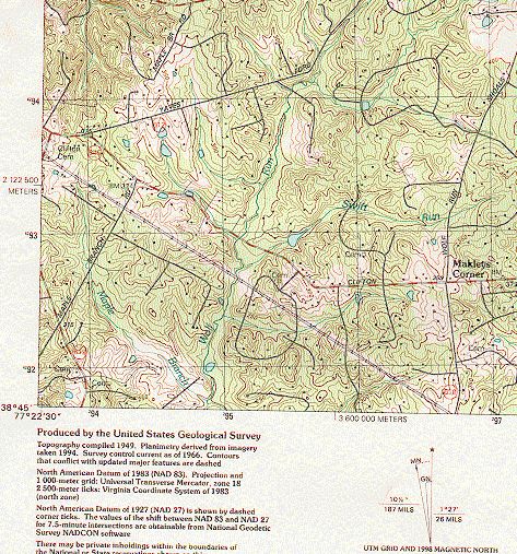
Refer to Figure 9 (pg. 29) for the following example.
A USNG reference is formally written as an entity without spaces, parentheses,
dashes, or decimal points. In this example the grid coordinates are shown for a
map feature, a small cemetery. From the legend the feature is located in GZD
(18S) and 100,000-meter square (TH). For the grid coordinates, read right to the
grid intersection immediately left of the place of interest. In Figure 9, it is line
95. Then identify the grid line below the point (in this example 92). The
coordinate value 9592 gives the location to within 1,000 meters. Measuring or
27Federal Geographic Data Committee FGDC-STD-011-2001
United States National Grid
Annex C – USNG Implementations
estimating right in meters from line 95, finds the cemetery is another 415 meters.
The complete USNG Easting component is 95415. Measuring up (north) from
line 92, the cemetery is another 635 meters. The complete USNG Northing
component is 92635. In this example a precision of 10 meters is required, thus
the eight-digit coordinate value of the cemetery is 95419263. Notice how the 1-
meter values of 5 have been dropped in the eight-digit grid coordinates. The
USNG coordinate values are:
Full USNG: 18STH95419263
Without GZD: TH95419263
Without GZD and 100,000-meter Square Identification: 95419263
Using the example of the cemetery above, grid coordinates are illustrated below
for four, six, eight, and ten digits. These values represent a point position (the
southwest corner) for an area of refinement.
Four digits 9592 Locating a point within a 1,000-meter square.
Six digits 954926 Locating a point within a 100-meter square.
Eight digits 95419263 Locating a point within a 10-meter square.
Ten digits 9541592635 Locating a point within a 1-meter square.
28Federal Geographic Data Committee FGDC-STD-011-2001
United States National Grid
Annex C – USNG Implementations
94
42 This figure illustrates how to obtain the spatial address for
a feature on the map, in this case a cemetery. Coordinates
are depicted as full and truncated values. Values
preceding grid coordinates are the Grid Zone Designation,
Grid: 18STH9541592635
and 100,000-meter Square Identification (In this case 18S
18STH95419263 and TH respectively). These values are found in the Grid
TH95419263 Reference Box in the map legend and are used as
95419263 appropriate to locate the feature within increasingly larger
954926 areas. A full coordinate (i.e. 18STH95419263) provides a
unique value over the entire world. TH95419263 provides
a value with 10-meters precision out of a large, regional
size area.
410-meters
Finding 95419263. Think 9541 / 9263.
- Reading right to grid line 95, measure right another 410-
meters. Dropping the one-meter digit 0 produces the grid
coordinate Easting value 9541.
Grid: 9592 630-meters - Read up to grid line 92. Measure up another 630-meters.
The Northing coordinate value is produced from grid line
92 + 630-meters (drop the 0) to make 9263. This makes
the grid coordinate 95419263 (think 9541 / 9263).
Truncated examples:
U.S. National Grid
Feature: USNG Grid Coordinates:
100,000-m Square ID
Bench Mark 324 94349341
3 00 Pond 94329206
TJ UJ Building 95649379
43 00 Road intersection 96189260
TH UH
Grid Zone Designation
18S
Map extract from US Geological Survey
7.5-minute quadrangle FAIRFAX, VA,
1994 edition.
Figure 9. How to read United States National Grid (USNG) grid coordinates.
29Federal Geographic Data Committee FGDC-STD-011-2001
United States National Grid
Annex D – General Conventions for the USNG
United States National Grid
Annex D (Informative)
General Conventions for the USNG
30Federal Geographic Data Committee FGDC-STD-011-2001
United States National Grid
Annex D – General Conventions for the USNG
ANNEX D (Informative)
General Conventions for the USNG.
D.1 Appropriate use of truncated values
Full USNG values should be provided when they are used to indicate a
geoaddress on stationary letterhead, business cards, etc., even though the reader
will know from the street address that it is in the vicinity of a given town. This
will facilitate someone using USNG geoaddresses with a GPS receiver or digital
map. For example:
Department of Interior
1849 C Street NW, Washington, DC 20006
USNG: 18SUJ22850705
Alternatively, when two people are exchanging positioning information by voice
or other informal means, they will often use only the USNG grid coordinate, such
as: "We're located in Washington at 1849 C Street, NW, grid 22850705."
A USNG spatial reference is formally written for general applications as an entity
without spaces, parentheses, dashes, or decimal points as depicted above. If
users must break a spatial reference into segments to facilitate reading, the
following convention shall be used.
18S UJ 228070
or
18S UJ 2286 0705
This convention is most appropriate in hand written notes or GPS receiver
equipment displays.
31Federal Geographic Data Committee FGDC-STD-011-2001
United States National Grid
Annex D – General Conventions for the USNG
D.2 Geographic indexing
D.2.1 National Atlas or Map
Features should be referenced in a map or atlas index using truncated USNG
values because such an index can then be used with any map conforming to this
standard thus promoting interoperability and the sharing of index information. In
the case of an atlas, the particular page numbers would also be indicated. For
example, the cities of Huntsville can be referenced as:
Huntsville, AL ED 3743
Huntsville, AR VV 3393
Huntsville, MO WD 3965
Huntsville, OH KE 6280
Huntsville, TN GF 2532
Huntsville, TX TQ 5501
Huntsville, UT VL 3567
The exception to this format is Alaska, which exceeds 18° of latitude and
longitude in extent (more than three grid zones). For Alaska, the GZD should
also be shown.
D.2.2 State map index
An index for a state atlas or map for Texas can reference cities as:
Huntington UQ 4961
Huntoon LF 5335
Huntsville TQ 5501
Huntsville St Park TP 5790
Hurlwood GT 7419
In the case of a state atlas, the page numbers for each feature would also be
indicated. The exception to this format is again Alaska, where the GZD should
also be shown.
32Federal Geographic Data Committee FGDC-STD-011-2001
United States National Grid
Annex D – General Conventions for the USNG
D.2.3 City street index
A large-scale atlas or street map for Huntsville, TX can index street names as:
Baker TP 562995
Beto TP 571981
Bowers TQ 570005
Brook TP 567984
Bush TQ 543021
The coordinate values would usually be for the place where the street name
appears on the map. Note that since the extent of Huntsville, TX is not larger
than 100 x 100 kilometers, the 100,000-meter Square Identifications are not
essential in this street index. A city street atlas would also reference the page
number unique to that atlas for the street.
D.3 Portrayal of USNG grids and grid values on maps
D.3.1 Grid spacing
On large-scale paper maps, precise measurement requires a fine line square grid.
Grids provide the user with a geodetic reference in close proximity to any point
on the map facilitating measurement and compensating for paper distortion. The
size of grid squares is a trade off between a precise reference and map clutter.
Table 2 provides a proven and useful convention and guide where grid squares on
maps are no smaller than 20mm nor larger than 100mm along each side.
33Federal Geographic Data Committee FGDC-STD-011-2001
United States National Grid
Annex D – General Conventions for the USNG
Table 2. Grid spacing recommendation
Map scale Grid spacing Grid spacing
(On ground in meters.) (On map in millimeters.)
1:10,000 1,000 100
1:20,000 1,000 50.0
1:24,000 1,000 41.6
1:25,000 1,000 40.0
1:50,000 1,000 20
or or
5,000 100.0
1:62,500 5,000 80.0
1:63,360 5,000 78.7
1:100,000 10,000 100.0
1:250,000 10,000 40.0
1:500,000 50,000 100.0
1:1,000,000 100,000 100.0
34Federal Geographic Data Committee FGDC-STD-011-2001
United States National Grid
Annex D – General Conventions for the USNG
D.3.2 Grid value portrayal
The USNG is based on the UTM grid, and as such the first two digits in USNG
Easting and Northing are the same as the 10,000-meter and 1,000-meter digits of
UTM Easting and Northing coordinates. Provisions should be made so map users
can have essential information for identifying the UTM coordinate equivalent of
each USNG coordinate. A sample of at least one full UTM value should be
shown for both an Easting and Northing values, preferably in the lower right
corner of the map. When UTM values are shown, the principal digits are
provided in larger type. Other grid lines should be identified using UTM
principal digits (both the 10,000-meter and 1,000-meter UTM values) with the
proceeding digits as superscript. Alternatively, only the principal digits for grid
lines need be shown, but a sample full UTM value for both the Easting and
Northing axis must be depicted at least once on the map. Annex C, Figure 6, 7,
and 8 (pgs. 24 – 26) depicts how grid lines are labeled and 100,000-meter squares
identified on the map and along the neatline.
D.3.3 Grid reference box
Maps at scales 1:500,000 and larger should provide a grid reference box with the
content illustrated in either Figure 4 or 5 (Annex C, pgs. 21 and 22) and similarly
configured.
D.3.4 Map legend information.
Map legends should contain the following information regarding the grid;
- Size of grid squares and identify grid as US National Grid
- Datum to which grid is referenced.
- Grid Zone Designation data.
- 100,000-meter Square Identification data.
Example for maps contained within a single 100,000-meter square:
1,000-meter grid, US National Grid
North American Datum 1983
Grid Zone Designation: 18S
100,000-m Square Identification: UH
Example for maps that cover two or more 100,000-m squares:
1,000-meter grid, US National Grid
North American Datum 1983
Grid Zone Designation: 18S
100,000-m Squares: TH, UH, TJ, UJ
35Federal Geographic Data Committee FGDC-STD-011-2001
United States National Grid
Annex E – USNG Standardized Numbering for NAD 27 Maps
United States National Grid
Annex E (Informative)
USNG Standardized Numbering for NAD 27
36Federal Geographic Data Committee FGDC-STD-011-2001
United States National Grid
Annex E – USNG Standardized Numbering for NAD 27 Maps
ANNEX E
USNG Standardized Numbering for NAD 27 Maps
Since the adoption of the NAD 83 as the U.S. national datum, there has been a sustained
effort by federal government mapping agencies to change national maps from the NAD
27 to the NAD 83 datum. However, a substantial percentage of maps over the U.S.
remain on the NAD 27 datum and that situation may continue for some time.
The U.S. National Grid (USNG) numbering scheme for the 100,000-meter squares, is
identical to the Military Grid Reference System (MGRS) scheme for 100,000-meter
squares designed for use with the WGS 84 over U.S. areas. This same numbering
scheme shall also be used with the NAD 27 on the Clarke 1866 ellipsoid for the USNG.
By use of one single scheme (Figure 3 – pg. 10), the Grid Zone Designation and 100,000-
meter Square Identification will be the same for NAD 83 and NAD 27 datums. The
ONLY difference will be in the two UTM coordinates, which will be based on the
geodetic coordinates as defined on their respective datums.
For example, the scheme for two adjacent 1: 24,000-scale quads within the same 100,000
meter square, e.g., FALLS CHURCH, VA-MD (NAD 83) and WASHINGTON DC
WEST, DC-MD-VA (NAD 27), would portray the same 100,000-meter Square
Identifications "UJ". The ONLY difference will be in the datum based UTM coordinates.
Example - The Washington Monument (USNG):
18S UJ 2348 0647 [NAD 83 is implied]
18S UJ 2345 0626 (NAD 27)
37Federal Geographic Data Committee FGDC-STD-011-2001
United States National Grid
Annex F - Glossary
United States National Grid
Annex F (Informative)
Glossary
38Federal Geographic Data Committee FGDC-STD-011-2001
United States National Grid
Annex F - Glossary
ANNEX F (Informative)
Glossary
ANSI American National Standards Institute
FGDC Federal Geographic Data Committee
GIS Geographic Information System
GPS Global Positioning System
GZD Grid Zone Designation
DMA Defense Mapping Agency
ISO International Organization for Standardization
MGRS Military Grid Reference System
NAD 27 North American Datum 1927
NAD 83 North American Datum 1983
NSDI National Spatial Data Infrastructure
NIMA National Imagery and Mapping Agency
PLSS Public Land Survey System
SPCS State Plane Coordinate System
UGRS Universal Grid Reference System
USNG United States National Grid
UTM Universal Transverse Mercator
WGS 84 World Geodetic System 1984
39You can also read