USGS Hawaiian Volcano Observatory Publications Available Online
←
→
Page content transcription
If your browser does not render page correctly, please read the page content below
USGS Hawaiian Volcano Observatory
Publications Available Online
The 2008–2018 Summit Lava Lake at Kīlauea Volcano, Hawai‘i
Professional Paper 1867
https://pubs.er.usgs.gov/publication/pp1867
The 2008–2018 lava lake at the summit of
Kīlauea marked the longest sustained period of
lava lake activity at the summit in decades and
provided a new opportunity for observing and
understanding lava lake behavior. The
individual chapters of this Professional Paper
volume cover the basic chronology of the
eruption, rich historical background,
observations and measurements of lake
activity, hydrological setting, as well as
geophysical and other monitoring data that
tracked the activity.
• Chapter A: Kīlauea’s 2008–2018 Summit Lava Lake—Chronology and Eruption Insights
• Chapter B: Views of a Century of Activity at Kīlauea Caldera—A Visual Essay
• Chapter E: Patterns of Bubble Bursting and Weak Explosive Activity in an Active Lava Lake—
Halema‘uma‘u, Kīlauea, 2015
• Chapter F: Groundwater Dynamics at Kīlauea Volcano and Vicinity, Hawaiʻi
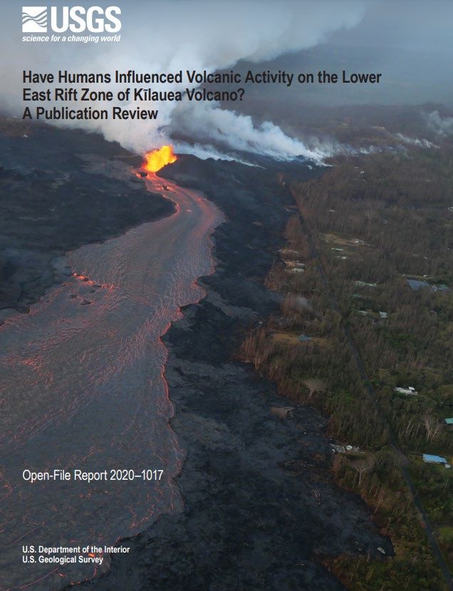
Have Humans Influenced Volcanic Activity
on the Lower East Rift Zone of Kīlauea
Volcano? A Publication Review
Open-File Report 2020-1017
https://pubs.er.usgs.gov/publication/ofr20201017
Since the 2018 eruption of Kīlauea Volcano, the topic of
whether commercial developments not only caused the
eruption to occur in the lower East Rift Zone (LERZ), but
also caused its high eruption rate has been a subject of
public discussion. We review Kīlauea Volcano publications
from the past several decades and show that the eruptive
behavior of the volcano has varied and that the 2018
eruption was similar to past eruptions in many ways. We
find no evidence to support any human influence on
Kīlauea Volcano.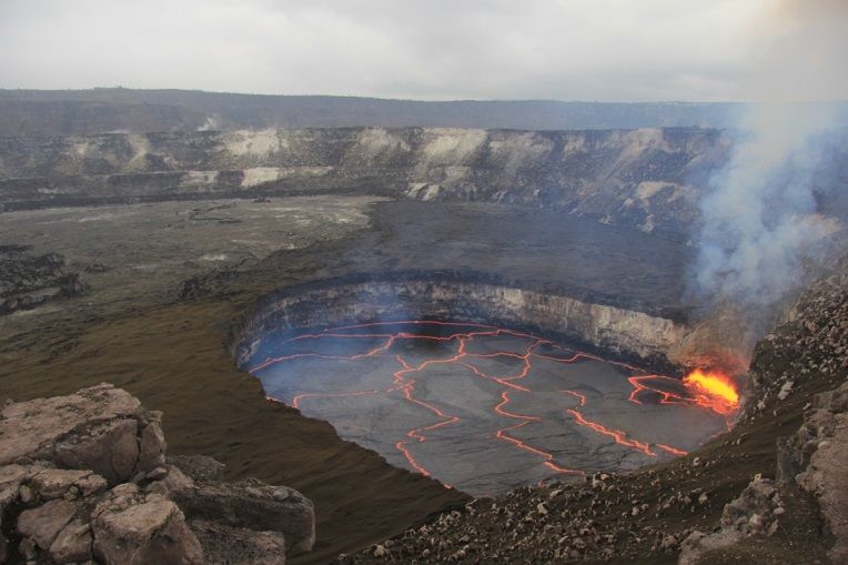
Preliminary Analyses of Volcanic Hazards at Kīlauea Volcano, Hawaiʻi,
2017–2018
Open-File Report 2020-1002
https://pubs.er.usgs.gov/publication/ofr20201002

From 2017 to 2018, the U.S. Geological Survey (USGS) Hawaiian Volcano Observatory (HVO)
responded to ongoing and changing eruptions at Kīlauea Volcano as part of its mission to monitor
volcanic processes, issue warnings of dangerous activity, and assess volcanic hazards. To formalize
short-term hazards assessments—and, in some cases, issue prognoses for future activity—and make
results discoverable to both the public and the authorities, HVO released reports online. These reports
were published rapidly, received peer review under the USGS’s Fundamental Science Practice
guidelines, and were intended to address a focused question posed by one or more cooperating
agencies—for this reason, they were called “cooperator reports.” This Open-File Report concatenates
four such products issued in 2017 and 2018 into a single publication. These reports have been
reformatted and lightly edited for clarity, but the content has not otherwise been changed from the
versions first publicly released.

The Lava Flow that Came to Hilo—The
1880–81 Eruption of Mauna Loa Volcano,
Island of Hawai‘i
Scientific Investigations Report 2019-5129
https://pubs.er.usgs.gov/publication/sir20195129

The Mauna Loa eruption sequence of 1880–81 consists
of two eruptions. The May 1880 eruption in
Mokuʻāweoweo at the summit of Mauna Loa lasted just a
few days and was followed 6 months later by three lava
flows that issued from vents along the Northeast Rift
Zone. The November 1880 eruption lasted almost a year
and one of its flows nearly reached Hilo Bay.

Public reaction in Hilo to the advancing lava flow
increased as the lava got closer, but a smallpox
quarantine prevented travelers and government officials
from leaving Honolulu, the government seat of the
Hawaiian Kingdom, until July 1881. In the King’s
absence, his sister Princess Regent Liliʻuokalani and key
officials met in Hilo at the beginning of August to plan a
government response. This included the first known plan
to use barriers and explosives to divert the lava flow in Hawaiʻi. Fortunately, the lava flow stopped
before the plan was enacted; however, both Christian prayer and traditional Hawaiian chants and gifts
to the Hawaiian deity Pele were offered in the last few weeks of lava activity.

Mauna Loa was again restless in 2019 and the time seems optimum to review this and other Mauna
Loa flows, in order to be ready for the next lava flow. Should the next flow threaten developed areas,
review of past lava flow threats may provide valuable experience on how the public may best be
provided with information.

Conversing with Pelehonuamea: A workshop combining 1,000+ years of
traditional Hawaiian knowledge with 200 years of scientific thought on
Kīlauea volcanism
Open-File Report 2017-1043
https://pubs.er.usgs.gov/publication/ofr20171043

                                                            The events surrounding volcanic eruptions
                                                            and damaging earthquakes in Hawai‘i have
                                                            often been described in journals, letters, and
                                                            newspapers articles in the English language;
                                                            however, the Hawaiian nation was among
                                                            the most literate of countries in the 19th
                                                            century, and many Hawaiian-language
                                                            newspapers were in circulation through all
                                                            but the earliest decades of the 19th century.
                                                            Any modern reconstruction of the history of
                                                            Hawaiian eruptions or earthquakes should
                                                            take advantage of all available sources, and
                                                            so we seek to add the Hawaiian-language
                                                            newspaper articles, journals, stories, and
                                                            chants to the volcano and earthquake
                                                            literature. These sources have been used in
                                                            many recent volcanological studies.

Another aspect to the mix of science and traditional Hawaiian values is that many of the volcanic
summits in Hawaiʻi are considered sacred to Hawaiians. Hawaiian travelers brought the first Western
missionary team to the summit of Kīlauea and advised them of the proper protocols and behaviors
while in this sacred area. The missionaries dismissed this advice as native superstition and they began
a campaign of aggressively stamping out customs and protocols related to the Hawaiian volcano
goddess Pelehonuamea. What has survived as native knowledge of the volcanoes is a few phrases
from native guides included in some of the missionaries’ journals, and a few stories. Pualani and Kuʻulei
Kanahele provide excellent introductions to the Pelehonuamea chants.

In the 21st century, amid a reawakening of Hawaiian culture, modern Hawaiians are demanding
protection of their sacred areas, and scientists must be aware of these interests. At the very least,
scientists should show respect to Hawaiian values when working in these areas, and should try to
minimize disruptions caused by their work. Kaeo Duarte, Peter Mills, and Scott Rowland describe
taking this approach in their field work.

Traditional knowledge is also contained in place names. It is important not only to preserve old place
names and to recover those no longer used, but also to preserve the stories of those places. Bobby
Camara talks about the joys and frustrations of getting information on and recovering Hawaiian place
names.

Finally, we hope that a broader interest in Hawaiian views about locations in Hawaiʻi where physical
scientific work is done will be as beneficial to physical scientists as it has been to life scientists
investigating Hawaiian lifeforms on land and in the ocean, and that both studies will continue to benefit
the native peoples of Hawaiʻi. Note that these proceedings are transcripts of oral presentations
illustrated with PowerPoint presentations or charts. Although every effort has been made to assure the
accuracy of the oral presentations, there are some gaps where words are not discernible in the voice
recordings and are so noted. In other places, bracketed words were added to clarify the speaker’s
meaning.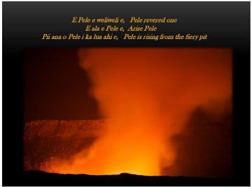
Campaign GPS measurements on the Island of Hawai`i collected by the
Hawaiian Volcano Observatory in 2019
USGS Data Release-2020
https://www.sciencebase.gov/catalog/item/5e7c1172e4b01d50927301f5
This dataset includes raw and rinex data from 2019 campaign gps data from the Island of Hawai`i in 2019.
There were a total of 69 sites occupied. All data is included along with metadata, log sheets and raw/rinex
data.

Digital elevation model of Kīlauea Volcano, Hawaiʻi, based on July 2019
airborne lidar surveys
USGS Data Release-2020
https://www.sciencebase.gov/catalog/item/5eb19f3882cefae35a29c363
The 2018 eruption of Kīlauea Volcano on the Island of Hawaiʻi saw the collapse of a new, nested caldera at
the volcano’s summit, and the inundation of 35.5 square kilometers (13.7 square miles) of the lower Puna
District with lava. Between May and August, while the summit caldera collapsed, a lava channel extended
11 kilometers (7 miles) from fissure 8 in Leilani Estates to Kapoho Bay, where it formed an approximately
3.5-square-kilometer (1.4-square-mile) lava delta along the coastline. Rapidly-deployed remote sensing
techniques were vital in monitoring these events. Following the eruption, the U.S. Geological Survey (USGS)
contracted the acquisition of rigorous airborne lidar surveys of Kīlauea Volcano's summit, middle East Rift
Zone, and lower East Rift Zone, also including the entire Puʻu ʻŌʻō lava flow field that was active from 1983
through early 2018. The surveys covered 567 square kilometers (219 square miles) at 30-100 points per
square meter, for a total of 53 billion points. Only 16 percent of these points (an average of 4 points per
square meter) were classified as ground due to extremely dense vegetation over much of the area. The
USGS used 2,570 point cloud files classified by Quantum Spatial to generate a single digital elevation model
(DEM) of the ground surface, including beneath-forest cover (that is, 'bare earth'). This USGS data release
contains digital elevation data as a 1-meter resolution raster dataset (.tif file). The DEM can support a variety
of earth science, civil engineering, and land use investigations.

Gas emission and ground temperature measurements at Puhimau thermal
area, Kīlauea Volcano, Hawai`i
USGS Data Release-2020
https://www.sciencebase.gov/catalog/item/5e7b56d2e4b01d509273004e
Puhimau thermal area, located in the upper East Rift Zone of Kīlauea Volcano, Hawai`i formed around 1936
when heat and gases migrated to the surface following a magma intrusion. As of April 2020, the area is
about 0.2 km2 in size with regions of steaming ground. The site may be valuable for monitoring changes in
gas and heat emissions related to movement of magma down the rift zone. On November 4-5, 2019 we
used the accumulation chamber method and thermocouple probes to make 164 measurements of soil CO2
flux and temperature (20 cm depth) at 30-m spacing on a 0.2 km2 grid. Three gas samples were collected
from areas of steaming ground on November 5-6, 2019 and analyzed for bulk chemical and carbon isotope
(d13C-CO2) compositions. These data were used to characterize the spatial extent and distribution of
volcanic CO2 emissions and thermal ground and estimate the total CO2 emission rate from the area.
Measured soil CO2 fluxes and temperatures ranged from 4.3 to 5880.0 g m-2 d-1 and 19.3 to 94.0 oC,
respectively. Gas samples contained mostly air components, with CO2 concentrations ranging from 3.7 to
10.0 vol.%. The d13C-CO2 value of the gas with the greatest amount of CO2 was -2.71‰.

Gas chemistry and isotope compositions at Sulphur Banks, Kīlauea
Volcano, Hawai`i
USGS Data Release-2020
https://www.sciencebase.gov/catalog/item/5fad8bbdd34eb413d5df4722
Sulphur Banks, near the summit of Kīlauea Volcano on the Island of Hawai`i, is a thermal area where
volcanic gases and steam are discharged. A research well drilled in the 1920s at Sulphur Banks (Allen,
1922) has developed into a “fumarole” that has been used for gas sampling over the years (e.g., Friedman
and Reimer, 1987; Hilton and McMurtry, 1997; Shinohara and others, 1999), but has not been subject to
periodic monitoring.

Following the 2018 Kilauea eruption, draining of the lava lake, and cessation of activity at the summit (Neal
and others, 2019), Sulphur Banks represents a continuing window into the outgassing dynamics at Kīlauea’s
summit. Gas samples were collected at Sulphur Banks periodically since March 2018 in evacuated bottles
for chemical compositional analysis and for stable carbon isotopes (d13C-CO2), and in copper tubes for noble
gas isotope ratio determinations. The goal of this effort is to track temporal variations that relate to volcanic
activity at Kilauea.

Gas concentrations were analyzed at the U.S. Geological Survey (USGS) Volcano Gas Geochemistry
Laboratory in Menlo Park, California using a Varian gas chromatograph with a dual-injection system using
argon and helium carrier gases (Bergfeld and others, 2014). Analyzed gases include carbon dioxide (CO2),
sulfur dioxide (SO2), nitrogen (N2), oxygen (O2), and argon (Ar), hydrogen (H), helium (He), and carbon
monoxide (CO). Stable carbon isotope ratios for the carbon dioxide component were measured at the USGS
Stable Isotope Laboratory in Reston, Virginia. Gaseous CO2 samples were analyzed on a dual-inlet isotope-
ratio mass spectrometer (Coplen, 1973) and normalized (Coplen, 1988) with CO2 reference gases prepared
using the method of Coplen and Kendall (1982). Noble gas isotope ratios were measured at the USGS
Noble Gas Lab in Denver, Colorado following methods described in Hunt (2015). Temperatures measured
during sampling with a K-type thermocouple and digital thermometer did not exceed 95.5°C, the
approximate boiling temperature at the site’s elevation (1230 m).

Gas concentrations are reported as volume percent, normalized to 100%. Stable carbon isotopes are
reported in permil (‰) notation relative to standard V-PDB (Vienna Pee Dee Belemnite). Helium isotope
data are reported as R/RA (3He/4He ratios in the sample over the ratio in the atmosphere).

Groundwater chemistry in the Lower East Rift Zone and summit of Kīlauea
Volcano, Hawai'i
USGS Data Release-2020
https://www.sciencebase.gov/catalog/item/5e95d72c82ce172707f252e7
Chemical and isotopic analyses are reported for water samples collected from water supply wells, a
geothermal well in the Puna Geothermal Venture (PGV) power plant, a hot spring in the Puna District, a
research well on the summit of Kīlauea Volcano (informally called “NSF Well”, or “Keller Well ”), and a water
catchment in the headquarters area of Hawai'i Volcanoes National Park, Hawai'i. These water samples were
collected and analyzed as part of research investigations on the potential impact of the 2018 Kilauea lower
East Rift Zone and summit eruption on water supplies. The presented data allow for a comparison with data
from an investigation carried out prior to the 2018 eruption (Evans and others, 2015 ). Water chemistry
analysis of samples from the research well on the summit of Kīlauea follows a previous data release and
research investigations (Hurwitz and others, 2003; Hurwitz and others, 2019 ; Hurwitz and Anderson, 2019).
Most samples were analyzed for dissolved and total major cations and anions, trace metals, and isotopes of
hydrogen and oxygen.

Continuous gravity data from Kīlauea Volcano, Hawaiʻi
USGS Data Release-2020
https://www.sciencebase.gov/catalog/item/5f73e77082cef8d1839962c7
This Data Release contains continuous gravity records from two instruments on Kīlauea Volcano, Hawaiʻi:
the HOVL gravimeter, located on the east rim of Halemaʻumaʻu Crater directly above the 2008-2018 summit
eruptive vent, and the PUOC gravimeter, located on northern rim of Puʻu ʻŌʻō crater on Kīlauea’s East Rift
Zone. Both instruments were collocated with GNSS stations. The HOVL gravimeter was installed in 2010
and operated until 2018, when it was destroyed by summit collapse. The PUOC gravimeter was installed in
2013 and operated until 2018, when it was removed following the cessation of eruptive activity at Puʻu ʻŌʻō.
Although both gravimeters have data gaps of varying lengths owing to equipment outages, the data provided
new insights into Kīlauea’s magmatic system that might not otherwise be known, including the density of
lava within the summit and Puʻu ʻŌʻō lava lakes and the occurrence of magmatic intrusions.

Water level, temperature and chemistry in a deep well on the summit of
Kīlauea Volcano, Hawai`i
USGS Data Release-2019
https://www.sciencebase.gov/catalog/item/5c8be87fe4b0938824529eec
Kīlauea, on the Island of Hawai`i is one of the world’s most active volcanoes and it hosts one of the densest
volcano monitoring networks. A deep well on the southwest rim of Kilauea’s caldera, often referred to
informally as the “NSF Well” or the “Keller Well” was drilled in 1973 to a depth of 1,262 meters from an
elevation of 1,103 meters. The ultimate goal of the drilling project was to “test predictions made from
surface-based geophysical surveys and seek evidence of a hydrothermal system over a known magma
body” (Zablocki et al., 1974; Keller et al., 1979). Following drilling the open hole filled up with drilling mud
and in October 1998 the hole was cleared of the mud using a large pump to a depth of about 2,200 feet
(~670 meters). Cleaning of the well renewed access to the hydrothermal system very close to the loci of
magmatic and fumarolic activity. Following drilling in 1973 and then again in 1999 downhole water level and
temperature measurements were made (Keller et al., 1979; Hurwitz et al. 2002). In July 2000, a package of
geodetic and seismic instruments was installed in the unsaturated part of the well at a depth of 1,200 feet
(366 meters) below the ground surface. A 2-inch (OD) PVC pipe between the instruments and the surface
allowed for water level and temperature measurements and waster sampling to continue. Between February
and June 2001, water level in the well was measured with a gas line and two pressure transducers (Hurwitz
and Johnston, 2003). Further attempts for continuous instrumental water level measurements by the USGS
have failed. The well was sampled several times between October 1998 and March 2002 for water
chemistry and isotope analyses (Hurwitz et al., 2003). It was revealed that the chemical and isotopic
compositions of the post-cleaning samples differ remarkably from water samples collected before cleaning.
Between March 2002 and May 2011, U.S. Geological Survey scientists have made periodic water level
measurements and collected water samples for limited chemical and isotopic analysis. The goal of this effort
was to track changes in water level and the concentrations of magmatic volatiles (chlorine, sulfur and carbon
dioxide) dissolved in groundwater in relation to volcanic activity in Kilauea. The data presented here includes
water level measurements, anion (sulfate, chloride, and fluoride) concentrations, and oxygen and deuterium
isotopes of sampled waters, and two temperature profiles that were measured in 2008 and 2019.

Strontium isotope ratios of lavas from Kīlauea, Mauna Loa, and Lōʻihi
Volcanoes, Hawaiʻi
USGS Data Release-2019
https://www.sciencebase.gov/catalog/item/5cbf3801e4b0c3b00664fd21
Strontium isotope ratios of lavas from Hawaiʻi were analyzed by thermal ionization mass spectrometry
(TIMS) at the Southwest Isotope Research Laboratories of the U.S. Geological Survey (USGS) in Denver.
There were at total of 427 analyses of samples obtained from the field, the collections of the USGS
Hawaiian Volcano Observatory (HVO), the University of Hawaiʻi, and the Smithsonian Institution. The
samples originated from Kīlauea (historical and prehistoric summit and rift zone lavas), Mauna Loa
(historical lavas), and Lōʻihi (submarine lavas of unknown age). Data for associated reference materials are
described in the process steps. The Sr isotope ratios may be used to test models for the magmatic plumbing
system of each volcano.

Repeat microgravity data from Kilauea Volcano, Hawai‘i
USGS Data Release-2019
https://www.sciencebase.gov/catalog/item/5d376d10e4b01d82ce8a7030
These data are microgravity measurements collected at the summit of Kilauea Volcano, Hawaii. Data are
collected using multiple instruments, with each file representing measurements from a specific instrument
during a specific time period. The data dictionary explains the file format and contents, and the dataset will
be updated as new measurements are collected.
Publications on Kīlauea’s 2018 lower East Rift Zone and
                      summit collapse
The historic events at Kilauea Volcano in 2018: summit collapse, rift zone
eruption, and Mw6.9 earthquake
Bulletin of Volcanology Special Issue
https://link.springer.com/journal/445/topicalCollection/AC_19594d79543c293556fc65ab9461ea
6b

The studies in this special issue address a wide range of topics related to the 2018 eruption. Among
these, Flinders et al. use ambient noise interferometry to characterize the state of the summit and East
Rift Zone in the years-to-months prior to the eruption onset and the ensuing eruption-related changes.
Dietterich et al. analyze unoccupied aircraft systems data to measure the effusion rates and dynamics
in the dominant lava channel on the LERZ. Kern et al. show the challenges of measuring SO2
emissions during an eruption of this scale, requiring modification of conventional techniques. Lerner et
al. address the petrologic underpinnings of these high SO2 emissions on the LERZ, and storage depths
of the magma. Johanson et al. examine coseismic and postseismic deformation fields from the Mw 6.9
earthquake on May 4, 2018, and how the event impacted the East Rift Zone and the ongoing eruption.

Many previous eruptions on Kīlauea, such as Kīlauea Iki, Mauna Ulu and Pu‘u ‘Ō‘ō, have spurred
decades of research and evolving ideas (Garcia 2015). We hope and expect that the research
presented in this special issue represents a foundation for many future studies in the coming years.

Research articles:

   •   The historic events at Kīlauea Volcano in 2018: summit collapse, rift zone eruption, and Mw 6.9
       earthquake: preface to the special issue
   •   Quantifying gas emissions associated with the 2018 rift eruption of Kīlauea Volcano using
       ground-based DOAS measurements
   •   Seismic velocity variations associated with the 2018 lower East Rift Zone eruption of Kīlauea,
       Hawaiʻi
   •   The petrologic and degassing behavior of sulfur and other magmatic volatiles from the 2018
       eruption of Kīlauea, Hawaiʻi: melt concentrations, magma storage depths, and magma recycling
   •   Lava effusion rate evolution and erupted volume during the 2018 Kīlauea lower East Rift Zone
       eruption
   •   Submarine lava deltas of the 2018 eruption of Kīlauea volcano

Unoccupied Aircraft Systems (UAS) video of the 2018 summit eruption of
Kīlauea Volcano, Hawai‘i
USGS Data Release-2021
https://www.sciencebase.gov/catalog/item/5f441b4582ce4c3d1222d9d4
This dataset contains Unoccupied Aircraft Systems (UAS) footage from the 2018 summit collapse
of Kīlauea Volcano, Island of Hawai‘i. The intrusion of magma into Kīlauea’s lower East Rift Zone triggered
draining of the summit lava lake and magma withdrawal from the shallow reservoir. This resulted in 62
subsequent collapse events at the summit between May and early-August 2018. Each collapse event
released energy equivalent to a magnitude-5.3 earthquake. The total collapse volume was about 0.8 km^3,
with subsidence of more than 500 m in some places. There are 73 UAS videos in this publication, recorded
from May 19 to September 5, which have been separated into subpages by month. Sub-pages for each
month also contain a ReadMe text file with information pertaining to the videos, including flight end time,
video duration, take off/landing location, keywords, and aircraft name. UAS flights were conducted with permission and in coordination with Hawai‘i Volcanoes National Park. Unoccupied Aircraft Systems (UAS) video of the 2018 lower East Rift Zone eruption of Kīlauea Volcano, Hawai‘i USGS Data Release-2021 https://www.sciencebase.gov/catalog/item/5ea8b45482cefae35a1faf94 This dataset contains Unoccupied Aircraft Systems (UAS) footage from the 2018 eruption of Kīlauea Volcano’s lower East Rift Zone (LERZ), Island of Hawai‘i. The four-month-long eruption, from May 3 to September 5, produced lava flows that destroyed 723 structures, inundated 35.5 km2 of land, and added 3.5 km2 of new land to the Island of Hawai‘i. There are 1178 UAS videos in this publication, recorded from May 27 to September 8, which have been separated into sub-pages by month. Videos taken during each month are separated into zipped files by date (YYYY/MM/DD) and location. Sub-pages for each month also contain a ReadMe text file with information pertaining to the videos, including flight end time, video duration, take off/landing location, visible active and inactive fissures, keywords, and aircraft name. A subset of these videos represents hover videos collected at nadir sites along the fissure 8 lava channel and several other locations for the purpose of measuring flow velocities and other channel monitoring. A document on the landing page describes the locations of these channel monitoring sites and the methodology used for video acquisition and recommendations for processing. Crater geometry data for Puʻuʻōʻō, on Kīlauea Volcano’s East Rift Zone, in May 2018 USGS Data Release-2021 https://www.sciencebase.gov/catalog/item/5f7d124b82ce1d74e7dbe4ad The 2018 lower East Rift Zone eruption and accompanying summit collapse of Kīlauea Volcano, Hawaiʻi, comprised one of the most impactful events on the volcano in the past 200 years, with hundreds of homes destroyed and major changes in the topography of the summit caldera. The opening stages of this eruptive sequence started on 30 April, when a magmatic dike began moving east from Puʻuʻōʻō, a cone with a central crater that was the vent region for Kīlauea’s 35-year middle East Rift Zone eruption starting in 1983. The rapid migration of magma from beneath Puʻuʻōʻō caused its crater floor to drop over 300 m. This data release includes a three-dimensional model of Puʻuʻōʻō and the collapse crater, constructed from aerial thermal images collected on 11 May 2018. Structure-from-motion processing was used to create the model from the sequence of oblique images, and ground control using kinematic GPS was used to georegister the model. These data provide a detailed record of the surface changes associated with the rapid magma migration that occurred on 30 April 2018. These data were used in the gravity study by Poland and others (2020, 2021). Volcanic plume heights from the summit of Kīlauea Volcano, Hawai'i USGS Data Release-2021 https://www.sciencebase.gov/catalog/item/6000a312d34e592d8671f57f This data release provides volcanic plume heights from the summit of Kīlauea Volcano for 2008-2015, and during the eruptive events of 2018. For 2018, a Secacam Wild Vision Full HD camera with a 7mm focal length was located at 1717 m elevation approximately 15 m south of the Mauna Loa Strip Road within Hawaiʻi Volcanoes National Park, 19.475843°N, 155.363560°W (WGS84). The camera was pointed southeast to capture images of the Kīlauea caldera every two minutes. These images were used to calculate maximum plume heights within the full frame of the camera. For each two-minute image, the maximum plume heights above the Halemaʻumaʻu crater rim, and in the overall image, were calculated using the horizontal distance to the plume feature, the inclination angle, camera focal length, pixel size, and basic trigonometry. For 3,518 images the plume height above Halemaʻumaʻu crater represents the maximum height in the image, and a '0' is indicated for the overall image (camera frame) plume height. For 4,325 images, no visible plume was discernable in the image directly above Halemaʻumaʻu (as a result of fog,
clouds, plume moving downwind, or other factors), and the maximum plume height in the entire camera
frame is reported, with a '0' indicated for the Halemaʻumaʻu plume height. Included in the release are all
83,320 images from 9 April, 2018 to 16 August, 2018. These images include both day and night, whether or
not a plume is visible.

Plume height data from 31 March, 2008 to 23 April, 2015 were recorded by an observer using a handheld
inclinometer while standing close to the corner of the low rock wall at the Jaggar overlook at 19.251065°N,
155.171629°W (WGS84). Date, time, approximate location of the highest plume feature, and inclination
angle were recorded. The horizontal distance to the highest plume feature, the inclination angle, and basic
trigonometry were used to calculate the maximum plume height above the elevation of the vent within
Halemaʻumaʻu.

High resolution earthquake catalogs from the 2018 Kilauea eruption
sequence
USGS Data Release-2020
https://www.sciencebase.gov/catalog/item/5dd7149de4b0695797650d0a
The 2018 Kīlauea eruption and caldera collapse generated intense cycles of seismicity tied to repeated
large seismic (Mw ~5) collapse events associated with magma withdrawal from beneath the summit. To gain
insight into the underlying dynamics and aid eruption response, we applied waveform-based earthquake
detection and double-difference location as the eruption unfolded. Here, we augment these rapid results by
grouping events based on patterns of correlation-derived phase polarities across the network. From April 29
to August 6, bracketing the eruption, we used ~2800 events cataloged by the Hawaiian Volcano
Observatory to detect and precisely locate 44,000+ earthquakes. Resulting hypocentroids resolve complex,
yet coherent structures, concentrated at shallow depths east of Halema‘uma‘u crater, beneath the eventual
eastern perimeter of surface collapse. Based on a preponderance of dilatational P-wave first motions and
similarities with previously inferred dike structures, we hypothesize that failure was dominated by coupled
shear and crack closure.

Differential Optical Absorption Spectroscopy data acquired during the 2018
rift eruption of Kīlauea Volcano
USGS Data Release-2020
https://www.sciencebase.gov/catalog/item/5dcc8303e4b0695797607f87
A fissure eruption occurred in Kīlauea Volcano’s Lower East Rift Zone (LERZ) from April to September
2018. During this event, volcanic gases were emitted from three active areas on the volcano. The most
intense degassing occurred at the active fissures in the LERZ, thus causing parts of Hawaiʻi Island’s Puna
district to be exposed to life-threatening sulfur dioxide (SO2) concentrations. At the same time, gas
emissions from the volcano’s summit and East Rift Zone (ERZ) slowly declined from their decade-long
averages as magma drained from the volcano’s shallow plumbing system. Throughout the eruption, the
USGS used a Mobile Differential Optical Absorption Spectrometer (Mobile DOAS) to record ultraviolet (280
– 420 nm) spectra of downwelling scattered solar radiation passing through volcanic gases overhead.
Mounted on a vehicle or carried by a hiking geologist, the instrument was passed beneath volcanic plumes
emitted from each of the three active areas throughout the 2018 eruption. The recorded spectra were later
used to retrieve SO2 vertical column densities in transects perpendicular to the plume propagation direction.
SO2 emission rates could then be calculated from these, thereby tracking the volcano’s gas output as the
eruption progressed. The resulting gas emission rates are published in the Bulletin of Volcanology
(https://doi.org/10.1007/s00445-020-01390-8). All recorded spectra were stamped with GPS time and
location. Each spectrum is saved in a separate ASCII file which includes 2048 radiances recorded across
the spectral window of the spectrometer along with relevant metadata associated with each acquisition
Geospatial database of the 2018 lower East Rift Zone eruption of Kīlauea
Volcano, Hawaiʻi
USGS Data Release-2020
https://www.sciencebase.gov/catalog/item/5eba3f6082ce25b5135d5b85
The 2018 lower East Rift Zone eruption of Kīlauea Volcano began in the late afternoon of 3 May, with fissure
1 opening and erupting lava onto Mohala Street in the Leilani Estates subdivision, part of the lower Puna
District of the Island of Hawaiʻi. For the first week of the eruption, relatively viscous lava flowed only within a
kilometer (0.6 miles) of the fissures within Leilani Estates, before activity shifted downrift (east-northeast)
and out of the subdivision during mid-May. Around 18 May, activity along the lower East Rift Zone
intensified, and fluid lava erupting at higher effusion rates from the downrift fissures reached the ocean
within two days. Near the end of May, this more vigorous activity shifted back uprift into Leilani Estates,
where fissure 8 reactivated with lava fountains feeding several ʻaʻā flows. The southernmost flow lobe
developed into a well-defined lava channel and reached the ocean at Kapoho Bay—11 kilometers (7 miles)
away—on 3 June. Fissure 8 continued supplying this lava channel for more than two months, constructing
an approximately 3.5-square-kilometer (1.4-square-mile) lava delta along the coastline. Over 4 and 5
August, activity at fissure 8 waned and flow in the lava channel came to a halt, only to be followed by weak
activity within the vent in late August and early September. By then, the eruption had covered 35.5 square
kilometers (13.7 square miles) of the lower Puna District with lava. In this report, the authors have sought to
chronicle this sequence of events using geospatial data in the form of an Esri file geodatabase, Esri
shapefiles, and Google Earth KMZs.

Whole-rock and glass chemistry of lava samples collected during the 2018
Lower East Rift Zone eruption of Kilauea
USGS Data Release-2019
https://www.sciencebase.gov/catalog/item/5d3279d2e4b01d82ce8791b2
This data release contains selected results of whole-rock and glass analyses of lava samples collected
during the 2018 eruption of Kilauea’s lower East Rift Zone (LERZ). Included are sampling-site information,
eruptive vent/fissure, and sampling descriptions. During the 2018 LERZ eruption, the chemical analysis of
lava samples was performed within hours of collection using an energy-dispersive X-ray fluorescence (ED-
XRF) pressed-pellet methodology. The accuracy of this method was evaluated by analyzing a subset of
samples using the more widely accepted wavelength dispersive X-ray fluorescence (WD-XRF) fused-bead
methodology. WD-XRF analyses were performed both during and after the eruption at the Hamilton
Analytical Lab, Hamilton College, New York. Results from both ED-XRF and WD-XRF, as well as summary
statistics on reference-material runs, are presented here for selected major and trace-element data. The
glass component of lava samples was analyzed separately using Electron Probe Microanalysis (EPMA). The
results of EPMA analysis of samples, as well as summary statistics on EPMA glass-reference-material runs
are presented for selected major and trace-element data. Also included in this release are the analytical
results from whole-rock and glass samples which are representative of magmatic end members, or eruptive
vent sites, on Kilauea volcano. This includes, a spatter sample collected from the “last gasp” of the Puu Oo
eruption during the collapse of that vent on May 1, 2018 preceding the LERZ eruption, select samples from
the Puu Oo vent preceeding the eruption, samples from the Overlook vent at Halemaʻumaʻu at the summit of
Kilauea, and finally a dacite-lava sample collected from a drilling well in the LERZ which may represent a
mixing end-member of the LERZ 2018 eruption.

Tiltmeter data from Kīlauea Volcano, Hawaii, spanning the 2018 eruption
and earthquake sequence
USGS Data Release-2019
https://www.sciencebase.gov/catalog/item/5d8c0330e4b0c4f70d0c339a
Data collected by 11 borehole tiltmeters operated by the U.S. Geological Survey on Kīlauea Volcano, on the
Island of Hawai'i. Data was collected between 30 April, 2018 and 5 August, 2018. Among the features
captured by this data set are: the collapse of Puʻuʻōʻō on 30 April, 2018, the migration of magma down the
East Rift Zone from 30 April to 3 May, 2018, the M6.9 earthquake on 4 May, 2018, and the deflation and
collapse of the shallow magma chamber at Kīlauea from early May until 5 August, 2018.

Cyclic lava effusion during the 2018 eruption of Kīlauea Volcano: data
release
USGS Data Release-2019
https://www.sciencebase.gov/catalog/item/5d92dd71e4b0c4f70d0d1cac
This USGS data release includes data related to the Science magazine manuscript “Cyclic lava effusion
during the 2018 eruption of Kīlauea Volcano” by Patrick et al. The data release includes 1) original video as
well as thermal, and timelapse images of lava in the proximal Fissure 8 channel, 2) derived estimates of lava
level in the channel and bulk effusion rates (not corrected for vesicles), 3) infrasound data, and 4) other
miscellaneous supporting data. The manuscript abstract is as follows: “Lava flows present a recurring threat
to communities on active volcanoes, and volumetric eruption rate is one of the primary factors controlling
flow behavior and hazard. The timescales and driving forces of eruption rate variability, however, remain
poorly understood. In 2018, a highly destructive eruption occurred on the lower flank of Kilauea Volcano,
Hawaiʻi, with the primary vent exhibiting dramatic cyclic eruption rates on both short (minutes) and long (tens
of hours) timescales. We use multiparameter data to show that the short cycles were driven by shallow
outgassing, while longer cycles were pressure-driven surges in magma supply triggered by summit caldera
collapse events 40 km upslope. The results provide a clear link between eruption rate fluctuations and their
driving processes in the magmatic system.”

Lava level and crater geometry data during the 2018 lava lake draining at
Kīlauea Volcano, Hawai‘i
USGS Data Release-2019
https://www.sciencebase.gov/catalog/item/5d842627e4b0c4f70d071a23
In May 2018, the onset of new eruptive activity on the lower flank of Kīlauea Volcano, Hawaiʻi, accompanied
the draining of the lava lake at the summit, 40 km upslope. The lava lake draining lasted over seven days,
and transitioned into the largest collapse event at the summit of Kīlauea in over 200 years, with the paired
flank and summit activity marking a historic episode in the modern record of Kīlauea. We present two
important datasets that characterize draining of the Kīlauea summit lava lake in 2018. First, we present high-
precision elevation data of the lava lake surface measured by an industrial laser rangefinder. To our
knowledge, this is the highest-precision lava lake elevation data ever collected over a sustained period.
Second, we present three-dimensional models of the drained crater on three dates during the draining
sequence. The models were constructed from oblique airborne thermal images using structure-from-motion
processing. These models constrain the crater geometry and can be used for measuring the volume of the
lava lake during its draining. This combined dataset may be useful for future research on the 2018 eruption.

Volcanic ash leachate and rainwater chemistry from increased 2018 activity
of Kīlauea Volcano, Hawai‘i
USGS Data Release-2018
https://www.sciencebase.gov/catalog/item/5b69cbe6e4b006a11f775784
In early May 2018, activity at Kīlauea volcano, Hawaii, increased, with heightened ash production from the
summit commencing on May 17. Volcanic ash can scavenge volatile components from volcanic plumes,
resulting in the deposition of potentially harmful elements during ash fallout. Leaching of these species (e.g.,
by rainfall or in water catchment systems) can have implications for agriculture, water resources and human
health.

The U.S. Geological Survey (USGS) is sampling volcanic ash and utilizing ash leachate analyses as part of
the assessment of hazards from the ongoing eruption of Kīlauea Volcano. We acquired 30 ash samples
erupted from the summit of Kīlauea Volcano and collected downwind between May 10 and May 28. The
samples were collected by either USGS scientists or citizens who live in areas experiencing ashfall. Care
was taken to source both proximal (
You can also read