Vulnerability of Bangladesh to Cyclones in a Changing Climate
←
→
Page content transcription
If your browser does not render page correctly, please read the page content below
WPS5280

Policy Research Working Paper                         5280

      Vulnerability of Bangladesh to Cyclones
              in a Changing Climate
             Potential Damages and Adaptation Cost

                              Susmita Dasgupta
                                Mainul Huq
                              Zahirul Huq Khan
                         Manjur Murshed Zahid Ahmed
                             Nandan Mukherjee
                              Malik Fida Khan
                                Kiran Pandey

The World Bank
Development Research Group
Environment and Energy Team
April 2010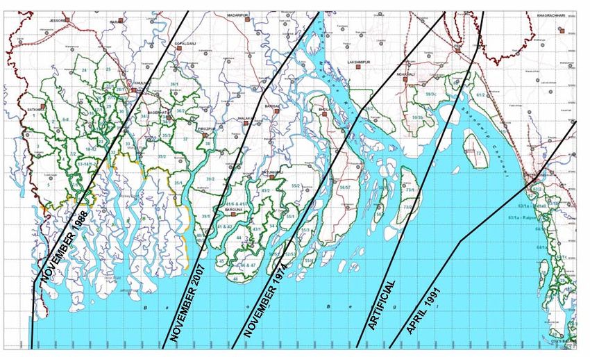
Policy Research Working Paper 5280

  Abstract
  This paper integrates information on climate change,                               inhabitants from tidal waves and storm surges. However,
  hydrodynamic models, and geographic overlays to assess                             in a changing climate, it is estimated that 59 of the 123
  the vulnerability of coastal areas in Bangladesh to larger                         polders would be overtopped during storm surges and
  storm surges and sea-level rise by 2050. The approach                              another 5,500 cyclone shelters (each with the capacity
  identifies polders (diked areas), coastal populations,                             of 1,600 people) to safeguard the population would be
  settlements, infrastructure, and economic activity at risk                         needed. Investments including strengthening polders,
  of inundation, and estimates the cost of damage versus                             foreshore afforestation, additional multi-purpose
  the cost of several adaptation measures. A 27-centimeter                           cyclone shelters, cyclone-resistant private housing,
  sea-level rise and 10 percent intensification of wind                              and further strengthening of the early warning and
  speed from global warming suggests the vulnerable                                  evacuation system would cost more than $2.4 billion
  zone increases in size by 69 percent given a +3-meter                              with an annual recurrent cost of more than $50 million.
  inundation depth and by 14 percent given a +1-meter                                However, a conservative damage estimate suggests that
  inundation depth. At present, Bangladesh has 123                                   the incremental cost of adapting to these climate change
  polders, an early warning and evacuation system, and                               related risks by 2050 is small compared with the potential
  more than 2,400 emergency shelters to protect coastal                              damage in the absence of adaptation measures.

  This paper—a product of the Environment and Energy Team, Development Research Group—is part of a larger effort in
  the World Bank to understand potential impacts of climate change and adaptation cost. Policy Research Working Papers
  are also posted on the Web at http://econ.worldbank.org. The author may be contacted at sdasgupta@worldbank.org.

          The Policy Research Working Paper Series disseminates the findings of work in progress to encourage the exchange of ideas about development
          issues. An objective of the series is to get the findings out quickly, even if the presentations are less than fully polished. The papers carry the
          names of the authors and should be cited accordingly. The findings, interpretations, and conclusions expressed in this paper are entirely those
          of the authors. They do not necessarily represent the views of the International Bank for Reconstruction and Development/World Bank and
          its affiliated organizations, or those of the Executive Directors of the World Bank or the governments they represent.

                                                        Produced by the Research Support Team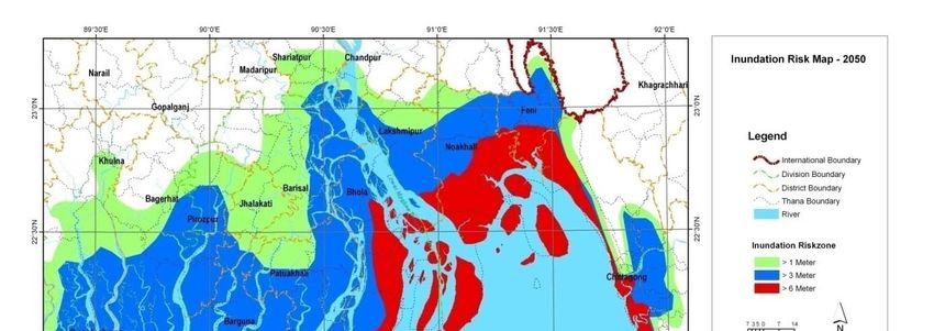
Vulnerability of Bangladesh to Cyclones in a Changing Climate:
                        Potential Damages and Adaptation Cost

                                      Susmita Dasgupta1

                                         Mainul Huq2

                                      Zahirul Huq Khan3

                              Manjur Murshed Zahid Ahmed4

                                     Nandan Mukherjee5

                                       Malik Fida Khan6

                                         Kiran Pandey7

Acknowledgements Financial support for this study was provided by the Economics of
Adaptation to Climate Change study administered by the Environment Department of the
World Bank. Funding for the Economics of Adaptation to Climate Change study has been
provided by the governments of the United Kingdom, the Netherlands, and Switzerland.

We would like to extend our special thanks to Ms. Maria Sarraf, Dr. Ainun Nishat and Mr.
Khawaja Minnatullah for their valuable guidance. We are thankful to Dr. Robert Mendelsohn
and participants of the Economics of Adaptation to Climate Change country consultations for
their useful comments and suggestions. We are also grateful to Ms. Roufa Khanam for her
valuable help with the GIS and Mr. Brian Blankespoor for editorial help.

1
  Lead Environmental Economist, Development Research Group, The World Bank, Washington DC,
USA.
2
  Development Policy Group, Dhaka, Bangladesh.
3
  Director, Institute of Water Modeling, Dhaka, Bangladesh.
4
  Senior Specialist, Institute of Water Modeling, Dhaka, Bangladesh.
5
  Adaptation Specialist, Climate Change Division, Center for Environmental and Geographic
Information Services, Dhaka, Bangladesh.
6
  Director, Climate Change Division, Center for Environmental and Geographic Information Services,
Dhaka, Bangladesh.
7
  Senior Economist, Environment Division, The World Bank, Washington, USA.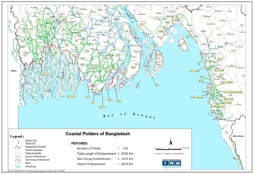
1. Introduction

An increase in sea surface temperature is strongly evident at all latitudes and in all oceans.
The scientific evidence indicates that increased sea surface temperature will intensify
cyclone activity and heighten storm surges.8,9 These surges10 will, in turn, create more
damaging flood conditions in coastal zones and adjoining low‐lying areas. The destructive
impact will generally be greater when storm surges are accompanied by strong winds and
large onshore waves. Tropical cyclone Sidr11 in Bangladesh (November 2007) and cyclone
Nargis12 in the Irrawady delta of Myanmar (May 2008) provide recent examples of
devastating storm‐surge impacts in developing countries.

Some recent scientific studies suggest that increases in the frequency and intensity of
tropical cyclones in the last 35 years can be attributed in part to global climate change
(Emanuel 2005; Webster et al. 2005; Bengtsson, Rogers, and Roeckner 2006). Others have
challenged this conclusion; citing problems with data reliability, regional variability, and
appropriate measurement of sea‐surface temperature and other climate variables (e.g.,
Landsea et al. 2006). Although the science is not yet conclusive (IWTC 2006: Pielke et al.
2005), the International Workshop on Tropical Cyclones (IWTC) has recently noted that “[i]f
the projected rise in sea level due to global warming occurs, then the vulnerability to tropical

8
   A sea‐surface temperature of 28o C is considered an important threshold for the development of
major hurricanes of categories 3, 4 and 5 (Michaels, Knappenberger, and Davis 2005; Knutson and
Tuleya 2004).
9
  A rising sea level as thermal expansion and ice cap melting continue will be another contributory
factor. The most recent evidence suggests that sea‐level rise could reach 1 meter or more during this
century (Dasgupta, et al. 2009; Rahmstorf 2007), although the likelihood of that magnitude of
increase remains uncertain.
10
   Storm surge refers to the temporary increase, at a particular locality, in the height of the sea due to
extreme meteorological conditions: low atmospheric pressure and/or strong winds (IPCC AR4 2007).
11
   According to Bangladesh Disaster Management Information Centre (report dated Nov 26, 2007)
3,243 people were reported to have died and the livelihoods of 7 millions of people were affected by
Sidr (http://www.reliefweb.int/rw/RWB.NSF/db900SID/EDIS‐79BQ9Z?OpenDocument ).
12
   In Mayanmar, 100,000 people were reported to have died and the livelihoods of 1.5 million people
were affected by Nargis (http://www.dartmouth.edu/%7Efloods/Archives/2008sum.htm )
cyclone storm surge flooding would increase” and “[i]t is likely that some increase in tropical
cyclone peak wind‐speed and rainfall will occur if the climate continues to warm. Model
studies and theory project a 3‐5% increase in wind‐speed per degree Celsius increase of
tropical sea surface temperatures.” The Intergovernmental Panel on Climate Change (IPCC
AR4, 2007) using a range of model projections, also has asserted a probability greater than
66% that continued sea‐surface warming will lead to tropical cyclones that are more intense,
with higher peak wind speeds and heavier precipitation (IPCC 2007; see also Woodworth and
Blackman 2004; Woth, Weisse, and von Storch 2006; and Emanuel et al. 2008).13

The historical evidence highlights the danger associated with storm surges. During the past
200 years, 2.6 million people may have drowned during surge events (Nicholls 2003).
Although significant adaptation has occurred over time, and many lives have been saved by
improved disaster forecasting, evacuation and emergency shelter procedures (Shultz,
Russell, and Espinel 2005; Keim 2006); recent disasters in Bangladesh and Myanmar have
demonstrated that storm‐surge losses still remain huge in many areas. Allocating resources
to increased disaster resilience along particularly vulnerable coastlines could reduce such
losses. The need for disaster preparedness along vulnerable coastlines is especially
pronounced in countries where concurrent scientific projections point towards more intense
cyclones in a changing climate.           However, setting a new course requires better
understanding of expected changes in storm surge patterns in the future, associated
damages and adaptation costs.

Currently, systematic studies of storm surge patterns in the future, location‐specific
potential damage and adaptation alternatives are scarce in developing countries. Analytical
work to date has been confined to relatively limited sets of locations, impacts and
adaptation measures (Ali 1999, Hoque 1994, Khalil, 1992). This paper is an attempt to

13
   Cyclones get their power from rising moisture which releases heat during condensation. As a
result, cyclones depend on warm sea temperatures and the difference between temperatures at the
ocean and in the upper atmosphere. If global warming increases temperatures at the earth’s surface
but not the upper atmosphere, it is likely to provide tropical cyclones with more power (Emmanuel et
al. 2008).
narrow the gap by providing itemized estimates of potential damage and adaptation cost out
to 2050 for Bangladesh‐ a tropical cyclone hotspot14 in a changing climate.

The focus of this research is on 10‐year return period cyclones ‐‐ cyclones with a 10% or
greater probability of occurrence each year. In the computation of potential damage, this
analysis concentrates on fatalities and injuries; and on housing, education, agriculture, non‐
agriculture productive sector, and infrastructure (roads, power, coastal protection), sectors
experiencing serious damage in the most recent 10 year return period cyclone in Bangladesh
(Sidr 2007). The primary objective of adaptation in this analysis is to avoid further damages
associated with storm surge inundation as a result of climate change with a particular focus
on various measures of adaptation to storm surges in Bangladesh. At the outset, we
acknowledge several limitations in our analysis. This analysis has not addressed the likely
problem of salinity intrusion nor has it addressed out‐migration from the coastal zone that
may be induced by sea level rise and more intense cyclones. We also have not attempted to
estimate location‐specific probability of 10‐year return period cyclones.

The remainder of the paper is organized as follows. Section 2 presents the case of cyclones
in Bangladesh. Our methodology and results are presented in Section 3, and Section 4
concludes the paper.

2. Cyclones in Bangladesh

Cyclones hit the coastal regions of Bangladesh almost every year, in early summer (April‐
May) or late rainy season (October‐November). Between 1877 and 1995 Bangladesh was hit
by 154 cyclones (including 43 severe cyclonic storms, 43 cyclonic storms, 68 tropical
depressions)15. Since 1995, five severe cyclones hit coast of Bangladesh coast in May 1997,
September 1997, May 1998, November 2007 and May 2009. On average, a severe cyclone
strikes Bangladesh every three years (GoB, 2009).

Bangladesh is on the receiving end of about 40% of the impact of total storm surges in the

14
  See UNDP, 2004; Nicholls, 2003.
15
   The Indian Meteorological Department (IMD) is responsible for tracking tropical storms and
cyclones in South Asia including the Bay of Bengal. Tropical storms are classified based on the
observed maximum sustained surface wind measured at a height of 10m averaged over 3 minutes as
follows: Super Cyclonic Storm (greater than 220 km/hour), very severe cyclonic storm (119‐220 km
/hour), severe cyclonic storms (90‐119 km/hour), cyclonic storms (60‐90 km/hour), Deep depression
(51‐59 km/hour), Depression (32‐50 km/hour) (IMD, 2010).
world (Murty and El Sabh, 1992). The reasons for this disproportional large impact of storm
surges on the coast of Bangladesh were reported16 to be the following:
The phenomenon of recurvature of tropical cyclones in the Bay of Bengal,
Shallow continental shelf, especially in the eastern part of Bangladesh17,
High tidal range18,
Triangular shape at the head of the Bay of Bengal19,
Almost sea‐level geography of the Bangladesh coastal land,
High density of population and coastal protection system.
The Meghna estuarine region is the area where most of the surge amplifications occur.
UNDP has identified Bangladesh to be the most vulnerable country in the world to tropical
cyclones (UNDP, 2004).
Inundation due to storm surges generated by severe cyclones pose a threat to lives and
(their) properties in the coastal region. Historical (time series) records of storm surge height
are scarce in Bangladesh. However, existing literature indicates a range of 1.5 to 9.0 meter
high storm surges during various severe cyclones. Storm surge heights in excess of 10 m or
even more are also not uncommon with an occasional reference in the literature. For
example, the Bakerganj cyclone had the greatest reported surge height of 13.6 m in 1876
and another cyclone had the height of 10 m in 1970 (SMRC, 2000).
A surge can be even more devastating if it makes a landfall during high tide. In general, it has
been observed that the frequency of a wave (surge plus tide) along Bangladesh coast with a
height of about 10 m is approximately once in 20 years, and the frequency of a wave with a
height of about 7 m is approximately once in 5 years (MCSP, 1993).
In addition to these exceptional surges, waves caused by wind also occur; the dimensions of
which depend on wind speed and direction, water depth, and duration of wind blowing over
16
For example, see Ali, 1999 .
17
The coast line of Bangladesh is characterized by a wide continental shelf, especially off the eastern
part of Bangladesh. This wide shelf amplifies the storm surges as the tangential sea‐level wind‐
stress field associated with the tropical cyclone pushes the sea water from the deep water side onto
the shelf. Being pushed from the south by wind stress, the water has no place to go but upwards;
which is the storm surge.
18
Records indicate 7‐8 m high tide in the Sandwip Channel.
19
The triangular shape at the head of the Bay of Bengal helps to funnel the sea water pushed by the
wind towards the coast and causes further amplification of the surge.the bay. It has been observed that wind induced waves of up to 3.0 m height may occur
under unfavorable conditions in the coastal regions (MCSP, 1993).Table 1 presents surge
inundation characteristics for cyclones of varying strength in Bangladesh as documented by
the MCSP (1993) (see Table 1).
According to the IPCC AR4, storm surges and related floods are likely to become more severe
with increases in intense tropical cyclones in future (IPCC, 2007). For the Bay of Bengal, a
study using dynamical models driven by RCM20 simulations of current and future climates
have shown large increases in the frequency of highest storm surges despite no significant
change in the frequency of cyclones (Unnikrishnan et al, 2006).21 Hence, from a practical
perspective vulnerability of Bangladesh to cyclones/ storm surges may increase even more
as a result of climate change.
3. Methodology and Estimates for Damage and Adaptation Cost
In order to estimate potential damage and cost of adaptation to potential intensification of
storm surges, this analysis has followed a 5‐step procedure:
1. Demarcation of potential vulnerable zone and projection of inundation depth from
storm surges;
2. Identification of critical impact elements: assets and activities exposed to inundation
risk;
3. Computation of potential damage and loss for a 10 year return period cyclone/ storm
surges out to 2050;
4. Identification of existing adaptation measures and quantification of changes that will
be required in a changing climate;
5. Costing of adaptation.
3.1 Demarcation of vulnerable zone and storm surge height:
This analysis has considered a sea level rise of 27cm22, increased wind speed (10%)23 and
landfall during high tide24 to approximate cyclones in a changing climate by 2050.
20
Regional Climate Model
21
For North Indian Ocean by 2100, a recent projection by Emanuel has indicated an increase in
intensity of tropical storms, as measured by percent change in landfall power, for the Model for
Interdisciplinary Research on Climate: MIROC (UN and World Bank, 2010).
22
Source: UK DEFRA (2007).
23
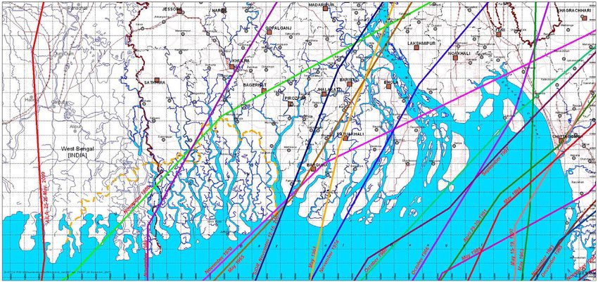
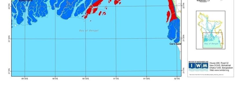
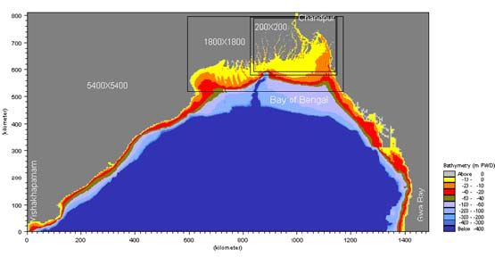
World Bank (2010).The inundation effect of storm surges has been assessed using the two‐dimensional Bay of Bengal Model recently updated and upgraded under the Comprehensive Disaster Management Program of Bangladesh (UK DEFRA 2007). The model is based on Mike 21 hydrodynamic modeling system, and its domain covers the coastal region of Bangladesh up to Chandpur and the Bay of Bengal up to 16º latitude. A detailed description of the model has been provided in Appendix 1. For approximating a condition of cyclones in Bangladesh without climate change, cyclone tracks of all major 19 historical cyclones making landfall in Bangladesh during 1960 and 2009 (For details, see Appendix 2) have been used with corresponding observed wind and pressure fields. For simulating the storm surge and associated flooding, the Bay of Bengal model was then applied to generate the extent and depth of inundation without climate change. Resulting inundation map is based on the maximum level of inundation at every grid points of the model. For approximating cyclones in a changing climate by 2050, potential cyclone tracks have been selected simulating 19 major cyclones making landfall in Bangladesh during 1960‐2009, and the affected coastal regions. From the historical cyclone simulations, it has been observed that the Sunderban coast, the southwestern coast (Sunderban to Patuakhali), the Bhola and Noakhali coast in the Meghna Estuary and eastern coast (Shitakunda to Bashkhali) are covered by 1974, 1988, 1991 and 2007 cyclone tracks. In order to include the Sandwip coast and the part of the Noakhali and Chittagong coasts at the central region of the Meghna Estuary, an artificial track has been generated. Figure 1 shows the five cyclone tracks considered for the determination of inundation zones due to climate change induced storm surges (see Figure 1). In order to determine potential future inundation zones in a changing climate by 2050, the storm surge model was run for the above mentioned five cyclone tracks covering the whole coastal area, incorporating a sea level rise of 27cm, 10% increase in wind speed, and landfall of the cyclones during high tide. Once again, inundation maps for 2050 with climate change have been generated based on the simulation results taking into potential intensification of cyclone induced inundation (See Figure 2). 24 Since scientific evidence to date is pointing towards an increase in frequency of intense cyclones in Bay of Bengal, probability of a potential landfall during high tide will also increase.
Resulting area estimates indicate a potential 69% increase in the vulnerable zone with more
than 3 m inundation depth and 14% increase in the vulnerable zone with more than 1 m
inundation depth with climate change (See Table 2).

3.2 Identification of critical impact elements exposed to inundation risk:

In order to identify critical impact elements exposed to inundation risk, geographic
Information System (GIS) software has been used to overlay the best available, spatially‐
disaggregated data on current assets and activities in the coastal zone of Bangladesh, with
the inundation zones projected for 2050 ‐ with and without climate change.

Impact elements considered in this analysis include: housing ‐ by building material type,
education institutions, growth centers, mills/ factories (large scale), national highways,
regional highways, feeder roads‐type A, feeder roads‐type B, bridges, power plants, power
transmission lines, deep tubewells, mosques, temples, historical places and tourist
destinations. Relevant exposure surface dataset for land area, population, poverty map, and
agriculture extent were also used. Exposure surface data were collected from various public
sources, such as Bangladesh Railways, Bangladesh Water Development Board, Local
Government Engineering Department (LGED), Center for Environmental and Geographic
Information Services (CEGIS), Public Works Department, Roads and Highways Department,
Water Resources Planning Organization and the World Bank. Estimates of exposure for each
indicator were calculated by overlaying the inundation zone with the appropriate exposure
surface dataset.

For the exposure grid surfaces, three GIS models were built for calculating the exposed
value. Exposure indicators, such as land surface, agriculture extent, road infrastructure and
railways were measured in square kilometers or kilometers. The values of the pixels in
population surfaces represent number of people, therefore the exposure is calculated by
multiplying the exposure surface25 with the inundation zone and then summing up by
multiplying grid count and value. Exposure estimates of other impact elements were counts.

25
     Population density of the lowest administrative unit, Thana, has been used in the computation.
Presently, our estimates indicate that 8.06 million inhabitants in coastal Bangladesh are
vulnerable to storm surge related inundation depth of more than 1m; the number will
increase 68% with population growth by 2050 even without climate change, and by 110 % by
2050 in a changing climate in the absence of further adaptation measures. Population
exposed to inundation depth of more than 3m will increase by 67% from current trends to
the 2050 scenario with climate change by 2050 (See table 3).
3.3 Potential Damage and loss from a 10 year return period cyclone/ storm surges in a
changing climate by 2010:
Exposure estimates of critical impact elements derived from geographic overlays provide the
basis for estimation of potential damage and loss from a 10 year return period cyclone
induced storm surges in a changing climate by 2050. In addition, the assessment of exercise
of potential damage and loss drew on the following:
a. Projection of growth in coastal population (1% per year) and GDP growth (6%‐8%
per year);
b. Experience of Bangladesh during the most recent devastating cyclone Sidr in
2007.26 (The extent of storm surge inundation during Sidr was 8.7% more than an
average inundated area of a historical 10 year return period cyclone of
Bangladesh.27 Accordingly, adjustment was made in computation of damage);
c. At present, average inundation area from one 10 year return period cyclone
covers 26% of the total vulnerable area and inundation from one future 10 year
return period cyclone (expected to be more intense) is likely to cover 43% of the
total vulnerable area;
d. All estimates have been adjusted for 2009 price level as per 18% increase in the
GDP deflator during 2007 and 2009.
In this analysis, damages include complete or partial destruction inflicted on assets (assets
not portable as well as stock), and losses refer to the flows of goods and services that will
26
It has been estimated that a cyclone like Sidr (wind speed of 223 km / hour) has a return period of
10 years in Bangladesh based on 21 major cyclone events from 1876 to 2009.
27
The extent of inundation includes area with inundation depth of 1 m or more.not be produced or rendered due to disasters. Losses also include disaster‐induced increases in costs incurred for continuation of essential services. Potential Human Casualty and Injury: Approximately 3.45 million coastal inhabitants of Bangladesh were exposed to storm surge related inundation during Sidr, 2007. Post disaster assessments indicate 3,406 human casualties and 55,282 injuries. Although cyclone shelters saved thousands of lives, focus group interviews with the residents of cyclone‐affected areas revealed that a large section of population was reluctant to move to cyclone shelters even during emergency. Distance from the homestead, difficult access to shelters, unwillingness to leave livestock behind unprotected, scarcity of sanitation facilities, lack of user friendly facilities for women, and overcrowded conditions in shelters are the primary reasons behind their reluctance. It has been estimated, under the assumptions of Bangladesh attaining replacement fertility rate by 2021 and an average 1.0% annual growth in coastal population per year between 2001 and 2050, a total of 5.34 million and 10.04 million coastal inhabitants will be exposed to the risk of a 10 year return period cyclone induced storm surge without and with climate change respectively by 2050. Extrapolation with the ratio of casualty to exposure (0.001), and the ratio of injury to exposure (0.016) experienced during Sidr indicates a risk of additional human casualties with an expected magnitude of 4,637, and an expected 75,268 injuries from a 10 year return period cyclone by 2050 as a consequence of climate change, in the absence of improved defensive measures.28 Improved defensive measures would contribute to reduced fatality and injury risk from increased exposure without climate change, in addition to the additional risk engendered by climate change. Attaching a monetary‐equivalent value to these risks that can be combined with and compared to risks of financial damage and loss is enormously difficult. The most appropriate measure of the benefit from reduced risk of fatality is the “Value of Statistical Life” (VSL), which seeks to estimate the monetary equivalent of improved well‐being for individuals from reduced mortality risk. In reality, VSL should reflect the context of the risk – for 28 Estimated human casualty is 5,274 without climate change by 2050, and in a changing climate the estimate is 9,911. Estimated injury is 85,609 without climate change by 2050; and in a changing climate the estimate is 160,877.
example, the risk of sudden fatality from an accident would be different from the risk of
reduced future life span from long‐term pollutant exposure.

Unfortunately, VSL values are all but non‐existent for developing countries, so it is necessary
to make rough approximations based on VSL estimates for developed countries, in particular
the USA. In this analysis a VSL of Taka 15.5 million (approximately $0.2 million) has been
used. This estimate for Bangladesh has been computed by updating the central estimate of
VSL of USA., $7.4 million ($2006) available from the EPA with price adjustment between
2006 and 2008 and GDP differential between USA and Bangladesh29. Multiplying this figure
by the expected value of the increased number of lives at‐risk from a 10 year return period
cyclone under climate change, an increased economic damage of $1.03 billion from greater
fatality risk has been estimated.

To calculate the economic damages from increased injury risk, a crude lower‐bound
estimate based on the WHO figure for cost per outpatient visit at a secondary hospital visit
in Bangladesh, $4.86 (Cropper and Sahin, 2009) has been adopted. This yields a total
economic damage from increased injury risk of $0.352 million. This estimate, however, does
not include any value of lost production and income from injury, or the more subjective
losses of well‐being resulting from being injured or incapacitated.

The balance of this section focuses on sectors experiencing high monetary damage and loss
during Sidr, 2007 – namely housing, education, agriculture, non agriculture productive sector
and infrastructure: roads, power, coastal protection. (See Box 1).

Potential damage in housing:

The housing sector experienced maximum damage and loss during the Sidr cyclone in 2007
and accounting by housing/ dwelling type further indicates that “semi‐pucka”30 houses,
“kacha”31 houses and “jhupris”32 were the predominant categories of damage.

29
   GDP Deflator 2008/ GDP Deflator 2006= 1.1; Per Capita USGDP ($ 2008, PPP) = 46,716 and Per
Capita Bangladesh GDP ($ 2008, PPP) = 1,334 have been used in this computation.
30
   Housing with foundation made of earthen plinth or brick and concrete, walls made of bamboo
mats, CI sheet and roof made of CI sheet with timber framing
31
   Housing with foundation made of earthen plinth with bamboo, walls made of organic materials
and roof thatched made of straw, split bamboo etc.
Analysis of the 2001 census data in Bangladesh reveals only 2.23% of rural households with
$470 per capita annual income33 or more could afford a “pucka” house, a brick house with a
concrete roof in 2001. However, Bangladesh is currently experiencing and expecting 6%‐8%
GDP growth per year for the coming decades. It is expected that approximately 98% of the
households will be living in brick houses by 2050, even after accounting for inflation. This in
turn implies a significant reduction in housing damages and a substantial increase in
household asset damages during cyclones over time.

Projection of population in coastal regions by 2050 without and with climate change
indicates that an additional 7.08 million inhabitants (i.e. an additional 1.45 million houses ‐
under the assumption of an average family size of 4.89) will be exposed to significant
damages from storm surges in a changing climate. Accounting for the larger areal extent of a
cyclone under climate change an additional 1.6 million houses are projected to be damaged
from a 10 year return period cyclone due to climate change.34 The size of a standard house
in Bangladesh is assumed to be 400 sq feet with 2,000 sq feet of brick wall surface and
approximate value of household assets is $2,143 (Tk 150,000). Under the assumption that on
average 50% of the walls and 50% of the household assets will be damaged during
inundation, re‐plastering the houses will cost $229 million (at Tk 10/ sq. ft) and an estimate
of household content damage is expected to be approximately $1.718 million.

Potential damage in education infrastructure:

The population projection indicates that with an additional 7.08 million inhabitants in coastal
Bangladesh exposed to storm surges in a changing climate by 2050; the expected exposure
of primary school students will be 456,690 (in 2,283 primary schools) and that of secondary
school students will be 312,957 (in 2,086 secondary schools).35 Accounting for the larger

32
   In Jhupris, ceiling, which is less than four feet, is made of cheap construction materials straw,
bamboo, grass, leaves, polythene, gunny bags, etc.
33
   Monthly income Tk 2,750 per capita.
34
   It has been assumed that inundation depth of 1m or less will have negligible impact.
35
   These estimates are based on the following assumptions: (a) ratio of children of primary school age
to total population will be 6.45% and the ratio of secondary school children to total population will
be 4.42% by 2050, (b) Bangladesh will attain 100% enrollment in primary schools and 70%
enrollment in secondary schools by 2050, which is the current rate of school enrollment of Brazil,
Lebanon, Malaysia, Uruguay –countries with per capita income similar to projected income for
Bangladesh in 2050, (c) the standard capacity of a primary school is 200 students and a similar size
school can accommodate up to 150 secondary students in Bangladesh.
areal extent of a cyclone under climate change an additional 4,840 primary and secondary
schools are projected to be damaged in a 10 year return period cyclone. According to the
standard specification of the LGED, the size of a standard school in Bangladesh is
approximately 160 sq m and its contents are worth $2,857 (Tk 200,000). Under the
assumption of expected average 50% damage to walls and contents during inundation, the
estimated (total) damage36 in a changing climate is $8.96 million.

The estimated total loss (cost of making alternative arrangements until the damaged
facilities are ready for use again) is $0.82 million.

Potential damage in agriculture:

Computation of potential damage and loss in the agricultural sector focuses on likely impacts
on crop production, livestock and fishery.

In the case of cereal production, this analysis is restricted to Aman, Aus and Boro variety of
rice, which are the main cereal crops of Bangladesh. In a changing climate, these crops are
expected to incur significant damage due to the expansion of storm surge inundation area.
The following parameters have been used for their quantification of potential damage (See
Table 4).

Historical records indicate the probability of Bangladesh being hit by a tropical cyclone in a
post‐monsoon season (67%) is higher than that in a pre‐monsoon season (33%). The
cropping calendar, planting ‐ harvesting dates, of Aman, Aus, and Boro are different37. As a
result, these crops are exposed to varying risk of storm surge inundation, and this difference
has been taken into account in the damage estimation. Under the assumptions that cereal
production will grow at the annual rate of 2.4% (observed annual growth rate during 2001‐
2007) in the future and there will be 50% damage in the yield if a 10 year return period
cyclone strikes, the estimated additional damage (primarily loss) for cereal is $788.83
million in a changing climate by 2050.

Sidr (2007) has inflicted a damage of $19.3 million to livestock and losses and damages of
$6.7 million to the fishery. Under the assumption that livestock and the fishery will grow at

36
     includes damage to the walls and therefore cost of re‐plastering and damage of contents.
37
     Aman grows in monsoon, Aus grows in pre‐monsoon and Boro grows in post‐monsoon season.
the annual rate of 3% and 6% respectively (observed annual growth rate during 2001‐2007) in the future, the estimated additional damage and loss for the livestock and fishery are $55.62 million and $66.36 million, respectively, in a changing climate by 2050. 38 Potential damage in non‐ agricultural productive sector: In 2007, Sidr triggered a total damage of $51.4 million to the non‐agricultural productive sectors. In 2007, non‐agricultural productive sectors (industries including small and medium size enterprises, commerce, tourism etc.) contributed to 82% of GDP of Bangladesh (World Bank, 2009). Economic structure of Brazil, Lebanon, Malaysia, Uruguay and South Africa ‐ countries with present per capita income similar to the projected per capita income of Bangladesh indicates that the share of the non‐agricultural productive sectors is likely to increase in Bangladesh by another 11% by 2050. GDP of Bangladesh is expected to increase 21.48 times between 2007 and 2050. Storm surge induced inundation area under Sidr, an average historical 10 year return period cyclone and a 10 year return period cyclone in a changing climate by 2050 are 588,512 hectares, 541,190 hectares and 1,017,008 hectares respectively. Combination of all the above implies an additional potential damage of $87.9 million in a changing climate, by 2050.39 The estimated potential additional loss is $1.084 billion. Potential damage in road infrastructure: In the case of storm surges, past experience suggests that roads are partially damaged when surge height/ depth of inundation is less than 1m, and fully damaged when the depth of inundation exceeds 1m. Under the assumption of 25% growth in road network between 2005 and 2050, geographic overlays of the road network and inundation zones indicate 3,998 km roads will be exposed to inundation depth of less than 1m and 8,972 km roads will be exposed to inundation depth of more than 1m by 2050 even without climate change. With climate change, the road exposure to less and more than 1m inundation depths will increase to 10,466 and 10,553 km respectively. Accounting for the larger areal extent of a 38 Estimated damage to livestock is $63.26 million without climate change, and $ 118.88 million with climate change‐by 2050. Estimated damage to fishery is $75.48 million without climate change, and $ 141.84 million with climate change‐by 2050. 39 Estimate of damage including loss but without climate change is $1.33 billion.
cyclone under climate change an additional 3,461 km of roads is projected to be partially
damaged and 2,205 km fully damaged from a 10 year return period cyclone. Repair costs of
Taka 1 million and Taka 2 million respectively in case of partial and full damage from the post
damage loss assessment exercise of Sidr in 2007 have been applied in the computation. The
post assessment of Sidr (2007) has further suggested that damages to bridges, culverts etc.
were 1.13 times the damages to roads. The combination of all these damages indicates an
additional damage of $239.5 million to roads, bridges, culverts etc. in a changing climate
by 205040.

The estimated potential additional loss in a changing climate is $52.7 million.41

Potential Damage in power infrastructure:

In 2007, Sidr induced a damage of $8.2 million in the power sector of coastal Bangladesh.
The projection of population indicates 1.53 times growth of coastal inhabitants in the coastal
area between 2007 and 2050. The consumption of power in Brazil, Lebanon, Malaysia,
Uruguay and South Africa ‐countries with the present per capita income similar to the
projected per capita income of Bangladesh indicates per capita consumption of power is
likely to increase 20 times in Bangladesh (and power infrastructure 5 times42) by 2050.
Damages recorded during the Sidr (2007) coupled with the projection of the change in
power infrastructure in the inundation areas (with and without climate change) indicates an
additional damage of $60.2 million. 43

The estimated potential additional loss is $150.0 million.

Potential damage in coastal protective infrastructure:

In the sixties, 123 polders and supporting infrastructure were constructed to protect low
lying coastal areas against tidal flood and salinity intrusion in Bangladesh. In 2007, Sidr

40
   Estimate of potential damages to roads, bridges, culverts etc. is $173.6 million by 2050 even
without climate change, and the corresponding estimate with climate change is $413.1 million.
41
   Loss estimates have been computed using 22% ratio between loss and damage in post Sidr
assessment.
42
   Experts of the Asian Development Bank working on Bangladesh power sector suggested this
adjustment factor.
43
   Estimates of potential total damage without and with climate change are $239.1 million and
$449.3 million respectively.
induced a damage of $70.3 million in the polders and related water regulators in coastal
Bangladesh. Past experience has identified “overtopping” of an embankment of a polder to
be the most important factor responsible for polder’s damage during cyclones.44
Comparison of projected surge heights and heights of existing embankments of polders
indicate an additional 15 polders are likely to be overtopped by 2050 in a changing climate,45
and the estimate of additional potential damage is $17.3 million.

To sum up, Table 5 presents itemized additional potential damage and additional potential
loss for an average 10 year return period cyclone induced inundation in a changing climate
by 2050 without adaptation. The estimates indicate if a 10 year return period cyclone
(likely to be more intense than current cyclones with climate change) hits Bangladesh,
additional potential damage is likely to be $2.437 billion and additional potential loss
$2.123 billion (See Table 5).

3.4 Mapping existing Coastal Protection in Bangladesh and gap analysis:

Bangladesh has an extensive infrastructure such as polders, cyclone shelters, early warning
and evacuation system to protect coastal regions.

a) Coastal Polders:
In the early sixties and seventies 123 polders, of which 49 polders are sea facing, were
constructed to protect low lying coastal areas against tidal flood and salinity intrusion.
Bangladesh Water Development Board (BWDB) maintains an extensive database of coastal
polders, and it includes information on length, location, construction year and cost for each
polder.46 See Figure 3 for the lay out map of the costal polders (See Figure 3).

Geographic Information System (GIS) software has been used to overlay the best available
spatially‐disaggregated data on polders in the derived vulnerable coastal zone of

44
   When water surge overtops an embankment, rapid and deep scours start to form on the country
side slope of the embankment. The process rapidly weakens the structure and leads to its collapse.
45
  Computation has been explained in details in the next section.
46
  In addition, information on riverbank and shoreline protection and re‐sectioning of embankment
works has been extracted from the Coastal Embankment Rehabilitation Project (CERP) and South‐
Eastern Zone‐Chittagong, South‐Western Zone‐Faridpur, Southern zone‐Barishal maintained by the
BWDB. It includes information on the ongoing projects, construction period and cost.
Bangladesh. Differences between the crest level of embankment of each polder and the
inundation depths projected for 2050 ‐ with and without climate change have been
computed to identify polders likely to be overtopped by intensified storm surges in a
changing climate and to quantify the potential extent of overtopping. The result indicates 26
interior polders and 33 sea facing polders in the coastal region will be overtopped in a
changing climate by 2050.

b) Foreshore Afforestation:
In the past, foreshore afforestation scheme proved to be cost effective in dissipating wave
energy, and in reducing hydraulic load on the embankments during storm surges47, but
Bangladesh has inadequate foreshore forests. At present, the total length of embankment
of 49 sea facing polders is 957 km, of which only 60 km has forest belts; and in many areas
the existing forest belt is degraded. Officials of the Department of Forests and experts of the
Institute of Water Modeling (IWM) have commented on the successes, failures and
sustainability of past foreshore afforestation measures. According to their recommendation,
a minimum of 500 meter width of mangrove forest is required for protection of sea facing
polders. In this analysis, existing length of coastal afforestation, between the coastline and
polders, has been estimated from Google Earth using GIS methodology; and the gap
between recommended 500 m wide mangroves and area‐specific existing ones has been
computed.

c) Cyclone Shelters:
At present, cyclone shelters in the coastal region of Bangladesh play a very important role in
protecting human lives and livestock during cyclones48. Although the need for and use of

47
   Benefit of foreshore afforestation was evident during the 1991 cyclone, Sidr (2007) and Aila (2009).
It was reported that massive devastation to property and loss of lives during the 1991 cyclone, in
Chokoria and areas around it, was primarily the result of virtual absence of mangrove forests along
their coasts (BCAS). An in‐depth study of the damages and losses inflicted by the Sidr (2007)has noted
that even scattered and unplanned forestation on the foreshore of the embankments has
substantially helped in breaking the velocity of storm surges (GoB, 2008).

48
  During the Sidr (2007), 15% of the affected population took refuge in cyclone shelters; and it has
been estimated that cyclone shelters saved thousands of lives.
cyclone shelters is expected to decline if polders are raised adequately and maintained
properly, cyclone shelters will still be needed in the following cases:
     a) a number of smaller yet inhabited islands may turn out to be cost ineffective to be
        protected by polders.      For those islanders, cyclone shelters will remain a vital
        necessity;

     b) in localities where projected inundation depth exceeds 3 m and inhabitants of single
        storied houses would need evacuation.

The total number of additional cyclone shelters required will depend on, and have been
calculated from the population likely to be exposed to inundation depth of more than 3m
from accentuated storm surges in a changing climate and the capacity of existing cyclone
shelters49. See figure 4 for location of existing cyclone shelters50 (see Figure 4).

d) Early Warning and evacuation System:

In the past, the early warning and evacuation system of Bangladesh has played an important
role in saving lives during cyclones. In general, Bangladesh Meteorological Department
issues forewarning for any impending cyclone and storm surge; newspapers, television
channels and radio stations broadcast the warning; and the local government administration
and the local Cyclone Preparedness Program (CPP) volunteers run by the Red Crescent
Society lead the evacuation of the people51.

Although the overall quality of forecasting cyclones and storm surges has improved over the
years, the general consensus is that there is scope for further improvement. At present, the
forecast of an area likely to experience a storm surge is usually over‐estimated and
delineated over a large section of the coastal zone, which can lead to unnecessary repetitive
evacuations and loss of popular faith in the early warning system. More precision in
forecasting, especially in the landfall location and location‐specific inundation depth, is

49
  Data and information on existing cyclone shelters are from the IWM and CEGIS, compiled from the
Public Works Department (PWD), LGED, Education Engineering Department, Red Crescent Society,
donor agencies, NGOs and local experts.
50
   Many of the existing cyclone shelters are in dilapidated condition. In a 2004 survey, CEGIS found
that more than 65% of the shelters had no provision for the special needs of women; almost no
facility was user friendly for people with disabilities; and 80% had no provision for livestock.
51
   Red Cross in Bangladesh
required. The Red Crescent Society officials, CPP volunteers and residents of major cyclone
affected areas also pointed out the urgent need for broadcasting the warnings in the local
dialects52 and the need to raise awareness for the importance of timely evacuation.
According to the CPP volunteers and residents of cyclone‐affected areas, in the past, a
significant number of fatalities could have been avoided had people not ignored/ resisted
evacuation until the last minute.
Experts in the Meteorological Department and the Red Crescent Society were consulted on
ways to improve the cyclone early warning and evacuation systems, and their
recommendations on improvement of cyclone modeling, upgrading of equipment, training
of personnel, and awareness raising programs have been considered for costing in this
analysis.
3.5 Costing of Adaptation:
In this paper, focus of adaptation is to avoid further damage from storm surge inundation
due to climate change. Hence, costing of adaptation relates to increase in inundation area
and inundation depth for a 10 year return period cyclone in a changing climate. The cost of
adaptation to an accentuated storm surge has been computed only for adaptation measures
relevant to Bangladesh. Hence, the adaptation measures considered in this analysis are the
following:
(i) Height enhancement of coastal polders;
(ii) Afforestation to protect sea‐facing polders;
(iii) Multipurpose cyclone shelters;
(iv) Cyclone‐resistant private housing;
(v) Strengthening the early warning and evacuation system;
Height enhancement of coastal polders:
For polders identified as “likely to be overtopped”, cost of height enhancement to avoid
overtopping has been computed as follows:
52
Illiterate poor people often experience difficulties in understanding sophisticated Bengali.(a) Differences between the crest level of embankment of each polder and the storm
surge level projected for 2050, with and without climate change have been computed to
quantify the potential extent of overtopping of an embankment.
(b) The amount of earth needed for this purpose has been derived from engineering
designs. Current local price for earthwork from the BWDB (Tk 109.96/ m3 if collected
from 300m to 1km distance; and Tk 133.44/ m3 if collected from 1km to 5 km distance)
has been used in the estimation. See appendix 4 for details.
(c) Compaction and turfing cost (Tk 7.07 per sq meter), used by the BWDB, have been
used to derive total related costs.
(d) As “toe erosion” of the embankment of polders is a serious problem in Bangladesh,
some sections of the polders would need hard protection. Cost of such hard protection
has been computed using the rate for using cement concrete (CC) blocks with sand filters
and geo‐textile, Tk. 224,100/meter ‐ the locally available technology, ranked as the best
technology so far. 53
(e) Height enhancement of embankments will require more land for strengthening the
bases. For sea facing polders, foreshore land is usually government owned or khas land.
For interior and marginal polders, however, neighboring land is often under private
ownership. Hence, requisition of such land would involve compensating the landowners,
and in some cases, their rehabilitation cost. This cost is included in the estimate.
(f) As per standard procedure of operation and maintenance (O&M) cost estimation, a
fixed percentage (2%) of capital investment has been assumed to be the regular
maintenance cost.
The result from this algorithm is in a projection of an adaptation cost of $892 million for
coastal polders (26 interior polders and 33 sea facing polders) in a changing climate. Table 6
summarizes the projected cost(s) for “interior” and “sea facing polders” without and with
climate change (See Table 6).
53
In order to protect minor erosion, the use of vetivera grass is often recommended. However, past
experience with the vetivera grass option is not very encouraging. The growth and survival rate has
been poor along the Chittagong belt, apparently due to a combination of factors including high
salinity of the soil. As the soil along the south‐western coast is even more saline, it’s not clear
whether vetiver is the right option for Bangladesh. However, in other regions Vetivera grass may
work, and cost of the vetivera plantation is Tk 70700/ ha.See Appendix 5 for itemized cost estimates for sea facing and interior polders. Coastal afforestation measures: As mangrove forests exist along some segments of the coastline of Bangladesh, only the additional cost of further afforestation is computed. At present, estimation from Google Earth using GIS methodology indicates 897 km length54 of existing sea polders would require mangrove forests for protection. This in turn implies that for a 500m wide protective forest belt, as recommended by the IWM officials, a foreshore area of 448.5 sq. km (= 897km x 0.5 km ) would need afforestation. At the current cost of afforestation of $168,000 / sq km55, the projected cost is US $ 75 million.56 Multipurpose Cyclone Shelters: Current consensus is in favor of multipurpose cyclone shelters with elevated space for livestock and overhead water storage, which can serve as a primary school / office space at times other than an emergency. In coastal Bangladesh, 8,059,185 people were exposed to storm surge related inundation depth of more than 3m in 2001. In 2050, with a projected growth of population57, 13,571,667 inhabitants will be exposed to storm surge related inundation depth of more than 3m even without climate change. In a changing climate with the projected expansion of the inundation zone as well as an increase in inundation depth coupled with a projected population growth, an additional 9,122,762 inhabitants will be exposed to a similar inundation risk. In estimation of the costing of multipurpose cyclone shelters, current cost and capacity of cyclone shelters have been collected from the World Bank funded projects. At present, a World Bank‐funded multipurpose cyclone shelter, under‐construction, with provisions for 1,600 people costs $214,000. In order to accommodate 9,122,762 inhabitants 54 At present, total length of 49 sea facing polders is 957 km, of which only 60 km has forest belts. 55 The cost of afforestation per hectare used is from the CERP II project. 56 With the addition of 500 m forest belt, requirement to enhance the elevation of embankments of sea polders may reduce by 30 cm in specific locations. 57 Population for the coastal region in Bangladesh 2050 has been projected under the assumption that Bangladesh will attain replacement fertility rate by 2021, and 68.4% growth of coastal population between 2001 and 2050.
exposed to inundation risk due to climate change, additional 5,702 multipurpose shelters
would be required at the estimated cost of $ 1.2 billion.58

Cyclone resistant private housing:

Inspection reveals that in the past cyclones, the housing sector has accounted for a
significant portion of damage. For example, during the severe cyclone of 2007, Sidr, damage
to the housing sector has been estimated to be $839 million accounting for 50% of total
damages to the economy (GoB, 2008). In the coastal region, houses can be made cyclone
resistant when suitable designs and building codes are followed. Upon consultation with
local Architects and Civil Engineers, this analysis is recommending a revolving fund of
$200million(for subsidizing construction material and extending subsidized housing
credit)59to encourage the construction of brick‐built houses with concrete roofs (on stilts, if
necessary) in accordance with the proper building codes. It is expected that these houses, in
turn, will serve as single/ multi‐family cyclone shelters during storm surges.

Strengthening the early warning and evacuation system:

Focus group interviews were conducted with the experts of the IWM, Bangladesh
Meteorological Department, the Red Crescent Society and residents of recent cyclone‐
affected areas on the requirements for strengthening the cyclone early warning and
evacuation system in Bangladesh. Experts of the IWM emphasized the need for improved
location‐specific inundation projection; officials of the Bangladesh Meteorological
Department emphasized the need for more accurate forecasting of cyclone landfall location
and inundation depth; and the officials of the Red Crescent Society, CPP volunteers and
residents of past cyclone affected areas emphasized the need for raising awareness to
promote proper and timely evacuation.

58
  In construction of cyclone shelters, selection of sites and proper accessibility should be considered
with caution. Some of the cyclone shelters in the past were sited and designed inappropriately.
59
  Subsidy systems should always be designed with caution so that misuse of subsidies can be
avoided.
For improvement in location‐specific inundation projections (basis of forecasting and
 adaptation planning), the IWM has pointed out the need for the following:

           Items                    Area                Per unit cost          Estimated Total
                                                                             Cost (in millionUS$)

Topographic Survey              23,500 sq km           US$200/ sq km                   5
LIDAR & RTK GPS Survey

Mathematical Modeling                                                                  3

                   Total                                                               8

 Officials of the Meteorology Department have identified the following requirements for
 strengthening the cyclone early warning system: a) modernization of existing 35
 observatories, b) establishment of additional 30 observatories, c) establishment of 5 new
radio stations, d) modernization of existing workshop and laboratory of the BMD, and e)
development of a training institute. Approximate costs of these requirements are as follows:

                                 Items                               Estimated Cost in
                                                                        MillionUS$
      1.   Modernization of the existing 35 (thirty five)                  6.00
           observatories of BMD

      2.   Establishment of additional 30 (thirty) modern                   12.00
           observatories of BMD at different locations of
           Bangladesh

      3.   Establishment of 5 (five) new Radio Sonde60                      2.00
           stations of BMD at different locations of
           Bangladesh

 60
    The radiosonde is a balloon‐borne instrument platform with radio transmitting capabilities. It
 contains instruments capable of making direct in‐situ measurements of air temperature, humidity
 and pressure with height, typically to altitudes of approximately 30 km. These observed data are
 transmitted immediately to the ground station by a radio transmitter located within the instrument
 package. The ascent of a radiosonde provides an indirect measure of the wind speed and direction at
 various levels throughout the troposphere. Ground based radio direction finding antenna equipment
 track the motion of the radiosonde during its ascent through the air. The recorded elevation and
 azimuth information are converted to wind speed and direction at various levels by triangulation
 techniques.
4. Modernization of existing workshop and 7.00
laboratory of BMD
5. Development of existing Training Institute 3.00
facilities of BMD
Total 30.00
Operational & Maintenance cost:
Items Estimated Cost in Million
US$ per year
1. Operational cost of existing 3+additional 5 RS 2.00
observatories for per year
2. Operational cost and maintenance cost of 3.00
existing 35+additional 30 observatories for per
year
Total 5.00
The current analysis has identified 19 coastal districts as vulnerable to accentuated storm
surge related inundation. The Red Crescent Society has recommended an annual awareness
promotion program of Tk 10 million (= US$ 142, 857) per district along with a Tk 20 million (=
US $ 285,714) overhead cost for the Center, summing to a total cost of US$ 3 million.
On further Infrastructural Investment:
As strong structural protection measures, such as polders, are being suggested in this
analysis, it reduces the need for making infrastructure (roads, bridges etc.) resilient to storm
surge related inundation, except in regions where there will not be any full‐scale structural
protection, for example in islands which are not and will not be protected by polders.
However, it should be noted that in these unprotected islands, there is not much
infrastructure to protect.
To sum up, Table 7 presents the itemized estimated cost of adaptation for storm surge
induced inundation in Bangladesh. The estimates indicate that an adaptation investment up
to $2.462 billion by 2050 would be needed to implement the measures discussed, even
without climate change. The estimate of the additional investment necessary to cope withYou can also read