Whatipu Our History - Pacific Jane
←
→
Page content transcription
If your browser does not render page correctly, please read the page content below
No. 04

Whatipu
Our History
WELCOME
Nau mai, haere mai
Whatipu sits on the northern
side of the entrance to the
Manukau Harbour. It is a remote
place with a large, open valley
dominated by bush covered
rocky peaks, and extensive black
sand dunes stretching out to the
wild waters of the Tasman Sea.
Whatipu appears to be a natural
place, yet people have gardened,
fished, lived and died here for
hundreds of years.

This brief history tells some of
the stories about the people
who have lived at Whatipu and
of the great drama that has
happened in this now quiet
place. Visitors to this part of
the Waitäkere Ranges Regional
Parkland can still see physical
reminders, such as pä (defended
fortifications), shell middens
(refuse heaps), railway sleepers
and historic buildings, that tell of
this remarkable history.

These carved pou (posts) represent
Te Kawerau ä Maki kaitiakitanga,
or guardianship, over Whatipu and the
surrounding seas. The pou facing inland
represents Tiriwä the ancestor after whom
‘The Great Forest of Tiriwä’ is named.
The pou facing out to sea represents
Taramainuku, the ancestor and guardian
taniwha associated with the Manukau
Harbour entrance.
Päraraha Mill site
Päraraha Pä
Päraraha 341 m
Päraraha Point
Foo
Valley
Track
te
St
re
m
a
Muir
Track
Taranaki
254 m 293 m
Ōhaka Head
Kaur
u
Str
eam
ki Stream
Mt Gillies
Stream
293 m Kura
Track
na
D
ROA
bons
Tara
am
Gib
tr e PU
uS ATI
W
ha
tip
WH
Gibbons
Track
Pascoe Point Makaka
Whatipu Mill site Bay
225 m
241 m
Whatipu Ōmanawanui Pā
Windy Point Liebergreen Lodge
Ōmanawanui
Cottage Track
Caves
P 180 m
Pukehühü Wonga Wonga
Bay
Wing’s house site
Wing Head
Te Marotiri ö Takamiro
Cutter Rock Paratütai Wharf site
Site of signal mast
Paratütai
Island
Te Toka Tapu ä Kupe
Ninepin Rock
MAP KEY
Heritage Site Walking Tracks Wetlands Lookout site Camping Information
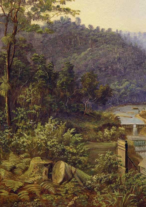
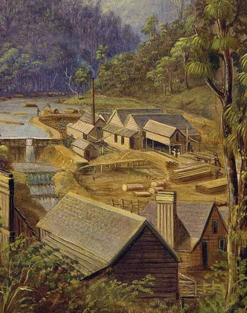
Cover image: ‘Bush Mill’, Whatipu, West Coast, Charles Blomfield 1880, oil on canvas,
purchased 1930. (Auckland Art Gallery Toi ö Tämaki)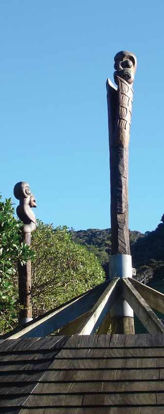
What To See And Do
• Take a walk from the carpark to the beach and Paratütai Island (40 minutes return) to
  gaze at the natural landscape that surrounds you. If fishing or swimming take great
  care, as the sea currents are powerful and sea conditions can change very quickly.
• Take one of the many signposted inland bush walks in the area. They range from
  easy strolls to overnight tramps.
• Walk out from the carpark to view the remarkable Giant Cave (1 hour return).
• Stay a while and learn some more about the area’s history. Book a stay at historic
  Whatipu Lodge, or book a campsite in the adjoining campground (telephone
  09 811 8860 or email whatipulodge@xtra.co.nz). The Lodge is operated under
  licence and can be visited by arrangement.
• Please do not remove or disturb any archaeological remains. They provide an
  important record of our history and are protected by law.

    How To Get There
                                                                             Hauraki Gulf
    Whatipu is located 42 km (1 hours drive)
                                                                                       Auckland
    from central Auckland. Head west to Titirangi   Waitakere Ranges                       CBD
    and then follow Huia Road. Take care driving           Titirangi
    on the last 7.5 km from Little Huia on the           Whatipu
    winding gravel Whatipu Road.                           Manukau Harbour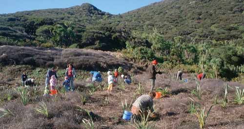
EARLY MÄORI OCCUPATION                               Türehu
The strategic position of Whatipu on the             Among the earliest human ancestors to live
northern side of the entrance to the Manukau         in the area were the Türehu people, literally
Harbour, and its rich natural resources,             ‘those who arose from the earth’. In local
attracted people from the earliest period of         tradition these ancestors had remarkable
Mäori settlement in the region. Whatipu              personal qualities and powers, including
was located at the southern end of a coastal         the ability to shape the land. They were
walkway which stretched all the way north            often referred to as ‘Ngä Urukehu’ because
to the entrance of the Kaipara Harbour and           of their fair skin and hair. One of the best
beyond. The flat, sandy, frost-free Whatipu           known of these people was the ancestor
Valley was ideal for the cultivation of kümara.      Tiriwä, who made his home at the mouth
The coastline provided a wide variety of             of the Päraraha Valley between Whatipu and
seafood. A huge amount of food, timber               Karekare. From Tiriwä comes the traditional
and medicinal plants was available from the          name for the Waitäkere Ranges – Te Wao nui
surrounding forest.                                  ä Tiriwä, the great forest of Tiriwä. Takamiro,
                                                     one of Tiriwä’s fellow Türehu chieftains, is
The long period of Mäori settlement can                credited with the creation of Cutter Rock at
be seen in many physical marks left on the             Whatipu. While standing at Hikurangi near
land. These include five pä (fortifications)              Piha during a meeting of tohunga (spiritual
that defended the land, terraces for houses,            leaders), he is said to have thrown his maro
shell middens (rubbish dumps from food                    (flax kilt) into the air. It flew to the south
processing and cooking waste), groves of                 and landed at Whatipu where it is now a
karaka trees, rock shelters and sacred places.           large rock (Cutter Rock) known as ‘Te
The place names and traditional stories told             Marotiri ö Takamiro’, or the flax garment
by the local people of Te Kawerau ä Maki                  thrown by Takamiro.
bring this physical landscape to life.
Their stories suggest that Whatipu
has been settled for a very long time.
                                                          Kupe mai tawhiti
Whatipu
                                                        Several famous Mäori ancestors and
The name Whatipu is said to be associated            voyagers are associated in tradition with
with an ancient taniwha, or spiritual guardian,      Whatipu. These illustrious ancestors include
who came from as far away as Tühua (Mayor            Toi te huatahi, and in particular Kupe mai
Island) in the Bay of Plenty and settled at          tawhiti. Kupe made a mark on Paratütai
the mouth of the Manukau Harbour.                    Island to commemorate his visit. He then
The small bay north of Paratütai Island              said sacred karakia (prayers or incantations)
(Figure 1) became the meeting place for              at Ninepin Rock in order to safeguard himself
Whatipu and his fellow taniwha, including            and his people who were being pursued.
Taramainuku, Paikea, Üreia and Kaiwhare.             It is for this reason that the Ninepin was
As a result, this bay also became known              given the traditional Mäori name ‘Te Toka
as Waitïpua, or the ‘bay of the spiritual            Tapu ä Kupe’, the sacred rock of Kupe.
guardians’. The small rocky islands that stand       (Figure 2) The powerful incantations chanted
off Whatipu are named after the ancestor             by Kupe raised up the seas behind his canoe
and taniwha Taramainuku. Together they are           so that those chasing him were forced to
known as ‘Te Kupenga ä Taramainuku’,                 take shelter. From that time the rough seas
the fishing net of Taramainuku.                       off the western coastline became known as
(If you visit Cornwallis Beach you can see a large   ‘Ngä Tai Whakatü ä Kupe’, the upraised seas
carving with an information panel that tells you     of Kupe.
more about the taniwha of the Manukau Harbour).                                                      1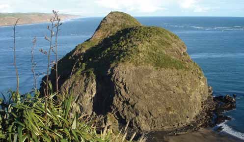
Paratütai Island and Pä                                                                Figure 1

    Ngäoho                                              Te Kawerau ä Maki
    In time other tribal groups visited the             In the mid 1600s, several large groups of
    Waitäkere Ranges and settled there. One of          Ngäti Awa people from the Taranaki–Käwhia
    these peoples was the Tini ö Maruiwi who            area began to migrate northward to settle
    came from the Taranaki area. On a clear             among their Ngäoho relatives. One of these
    day, while standing on the high ridge north         Ngäti Awa groups from Käwhia was led
    of Whatipu, these people could see their            by a famous warrior chieftain Makinui who
    beloved mountain Taranaki to the south.             was generally known as Maki. He and his
    It is for this reason that they named the bay       people first settled on the Tämaki Isthmus
    and large hill just north of Whatipu, ‘Taranaki’.   (Auckland). They then moved to the southern
                                                        Kaipara area where they became known
    In the 14th century the Tainui canoe                as Te Kawerau ä Maki, a name which their
    arrived in what is now the Auckland region.         descendants have retained to this day.
    The famous Tainui spiritual leader Rakataura        Maki took control of the Waitäkere Ranges
    visited Whatipu and the Waitäkere coastline,        after battles with Ngäoho at Muriwai, Piha,
    bestowing such names as Tïtïrangi and               and Päraraha near Whatipu. The peaks of
    Hikurangi on the land after places in his           the ranges became known as ‘Nga Rau Pou
    Pacific homeland. Hoturoa, the commander             ä Maki’, the many posts of Maki, and he
    of the Tainui canoe, also bestowed names on         bestowed the name ‘Rau ö Te Huia’ (Huia
    the surrounding area. Some of the crew of           Bay) in memory of his home at Käwhia.
    the Tainui settled in the area, married earlier     Maki also named a hill standing to the east
    local people, and adopted the collective            of Whatipu, ‘Te Kä ä Maki’ to symbolize
    tribal name ‘Ngäoho’. These people lived            his ‘long burning fire’ or occupation of the
    throughout the Auckland region, including           land. Maki settled at Kaipara and later at
    at Whatipu.                                         Mahurangi, while his only Kaipara-born child
                                                        Täwhiakiterangi (better known as Te Kawerau
                                                        ä Maki) settled at what is now Woodhill.
2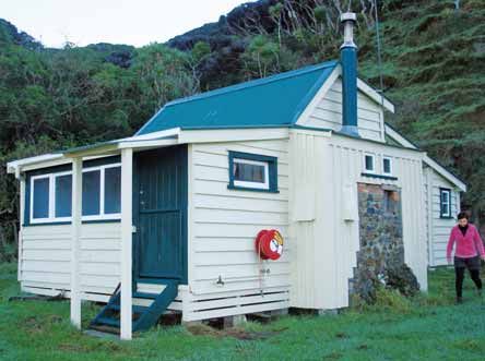
The descendants of Täwhiakiterangi lived         Following this event Te Kawerau ä Maki
throughout the Waitäkere Ranges and West         remained in occupation of the Waitäkere
Auckland. They held the land in turbulent        Ranges, including Whatipu, and they made
times. As a result they built many fortified      further peace-making marriages with Ngäti
pa, including those at Whatipu. They also        Whatua. Soon after however, their leader
made peace-making marriages with their           Täwhiakiterangi was killed near Woodhill
Waiöhua relatives who lived on the Tämaki        and they retaliated by killing a Ngäti Whatua
Isthmus and around the Manukau Harbour,          group which was visiting Piha, and then by
and with Ngäti Whätua who were then              killing Käwharu. After a generation of peace
forming their identity in the northern Kaipara   and further intermarriage between the two
area. Tension however arose between Te           tribes, Ngäti Whatua sought to avenge the
Kawerau and Ngäti Whätua, and developed          death of Käwharu and several large war
into open conflict following the killing of       parties attacked the Kawerau communities
Haumoewhärangi, the paramount chief of           of south western Kaipara. They were
Ngäti Whätua.                                    successful in defeating Kawerau in several
                                                 major battles and settled in south western
At the time the famous warrior Käwharu was
                                                 Kaipara.
visiting his Kawerau relatives in southern
Kaipara. Even though he was from Käwhia          Te Kawerau ä Maki were pushed southward.
and closely related to Maki, he was also         However, after a series of peace making
related to the widow of Haumoewhärangi.          meetings and marriages, they remained in
Käwharu saw the killing of Haumoewhärangi        occupation of their land extending south
as inappropriate and offered to take revenge.    of a line from Muriwai to Riverhead. Te Au
He gathered a war party and chased those         ö Te Whenua the Te Kawerau ä Maki chief
responsible south to the Waitäkere Ranges        who then lived at Te Korekore Pa, Muriwai,
where he killed them at Makaka (Destruction      concluded a peace known as ‘Te Taupaki’.
Gully) east of Whatipu. Käwharu then             During the Ngäti Whatua conquest of the
exacted muru (ritual plunder) on those of        Tämaki Isthmus in the mid 1700s, a major
Te Kawerau ä Maki who had sheltered the          battle was fought on Te Kawerau ä Maki
killers. During this episode known to Ngäti      land near Tïtïrangi, but Te Kawerau ä Maki
Whatua as ‘Te Raupatu Tïhore’, ‘the stripping    remained neutral in this episode as they
conquest’, the valued belongings of many         were related to both parties involved in the
of the Te Kawerau ä Maki settlements were        fighting. Te Kawerau ä Maki continued to
taken. This included those of the occupants      occupy the Waitäkere Ranges, including
of the pa on Paratütai Island (Figure 1)         Whatipu, from this time.
at Whatipu.

 Te Toka tapu ä Kupe (The Ninepin)                                                     Figure 2

                                                                                                  3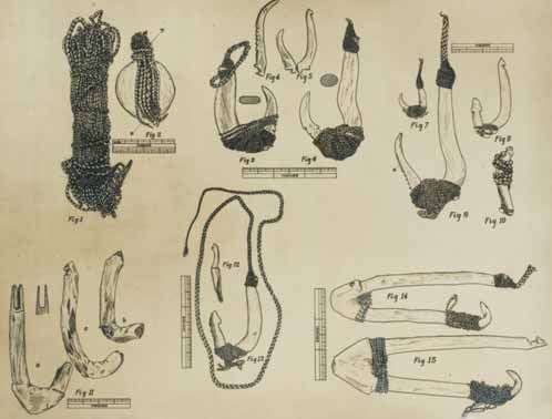
THE TRADITIONAL CYCLE OF                            Most importantly the rocky and sandy
    RESOURCE GATHERING                                  coastline at Whatipu also provided a
                                                        wide range of resources from the sea.
    As with all Mäori in pre-European times,
    Te Kawerau ä Maki did not generally occupy          At Whatipu, settlement appears to have
    permanent settlements. Rather they                  been concentrated around the lower valley,
    moved around their ancestral land according         on and behind the sand dunes, and in the
    to the seasons in a cycle of hunting,               vicinity of the present day campground.
    fishing, gathering and harvesting. They              Evidence of settlement is still to be seen in
    had settlements around the mouth of the             the many terraces, caves, and rock shelters
    Whatipu Valley, to the east at Te Rau ö Te          found throughout the area. In particular it
    Huia (Huia Bay), along the northern shores          can be seen in the large number of shell
    of the Manukau Harbour, around the shores           middens (refuse heaps) located in the lower
    of the upper Waitematä Harbour, and along           Whatipu Valley, and at many places along
    the coastline to the north of Whatipu,              the coastline. These deposits contain a
    extending from Päraraha to Karekare,                considerable amount of fishbone, as well as
    Anawhata, Piha, Te Henga and Muriwai.               seal and whale bone. Whales that became
                                                        stranded on the Whatipu shoreline were a
    Whatipu was an important place, and an              wonderful gift from the sea. They provided
    ideal place to live in pre-European times.          a considerable amount of food, and also
    It is sited at the mouth of the Manukau             bone which could be used to manufacture
    Harbour which was the gateway to Tämaki             a wide range of tools and ornaments.
    Makaurau (the Auckland Isthmus) and                 Whale strandings have continued to occur
    beyond. It was also located at the southern         at Whatipu over the last 150 years, with a
    end of a coastal trail that ran down the            major stranding of twelve sperm whales
    beaches, cliffs and ridgelines from Muriwai         occurring as recently as November 2003
    to Whatipu. The area was surrounded by              (Figure 3).
    coastal forest which provided a wealth of
    food, medicines and building materials.

     Whale stranding at Whatipu, November 2003, DOC Auckland                                 Figure 3

4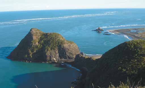
Mäori Fish-Hooks from Manukau Heads, from F.G. Fairfield                                  Figure 4

     The harvesting of the resources of the sea is also reflected in the many artefacts
     that have been recovered from Whatipu over the years. These artefacts incude a
     special two-piece hook for hapuku, trolling lures, harpoon heads, stone sinkers,
     a wide variety of wooden fishhooks (Figure 4), and even fragments of flax fibre
     fishing lines and nets.

The many middens in the Whatipu area                  probably came from Huia Bay. Most of the
contain a wide range of shellfish. These               middens also contain charcoal and hängi
include: mussels, tuatua, hopetea (white              (oven) stones which indicate that shellfish
rock shell), oysters, cat’s eye, paua, pipi           and fish were cooked at these sites over
and limpet, that were harvested from the              many years.
Whatipu coastline, as well as cockles which
                                                                                                     5
Karaka (Corynocarpus laevigatus) trees                                   These pits were also sometimes used as
    are associated with many of the old Mäori                                houses and their earthwork remains can
    occupation sites in the Whatipu area.                                    still be seen at many sites in the area.
    The fruit of the karaka (Figure 5) was                                   Taro would also have been grown in
    gathered from planted groves in March.                                   wet areas beside the Whatipu Stream.
    The fruit was then soaked to remove
    poisonous toxins and it was pounded to                                   The rich resources of Whatipu were
    produce a form of flour used as a winter                                  protected by five pä (defended fortifications).
    food source.                                                             They include: two hilltop pä inland of Whatipu
                                                                             Lodge, an island pä on rocky Paratütai Island,
                                                                             a headland pä below Pukehühü, and a ridge
                                                                             pä at Ömanawanui. These pä were built to
                                                                             provide safe places in times of war, and were
                                                                             located on steep places that were difficult
                                                                             to attack. The remains of Ömanawanui Pä
                                                                             (Figure 6) can be seen on the Ömanawanui
                                                                             Track which can be accessed from the
                                                                             main carpark, or from Whatipu Road. At
                                                                             this pä Mäori built a defensive ditch with an
                                                   Figure 5                  accompanying earth bank across the narrow
                                                                             ridge-line. These visible defensive features,
                                                                             along with pallisade posts and the naturally
                                                                             steep sided ridgeline, would have defended
    Te Kawerau ä Maki, and the people who
                                                                             what appears to be the main kumara storage
    came before them, cultivated kümara
                                                                             place in the Whatipu area. Within the
    gardens in the warm sandy soils found in the
                                                                             defended area, the ridge was levelled and
    Whatipu Valley and in the Päraraha Valley to
                                                                             reshaped to form two long terraces which
    the north. The kümara tubers were stored
                                                                             contain 13 rua.
    in rua (rectangular pits) with thatched roofs.

     D E F E N D E D      F O O D   S T O R A G E                           L I V I N G   A R E A S

                       tihi     rock

                                           käraka trees
                                                                                             house site   rock (view point)

                                                                                              S T E E P

           S     T        E    E       P
       terrace                 kümara storage pit         defensive ditch            walking track
                                                          and bank

     Archaeological Plan of Ömanawanui Pa (not to scale), Vanessa Tanner                                              Figure 6

6
CONTACT WITH EUROPEANS Te Whakapono - Christianity
AND ITS IMPACTS
Soon after their return home from exile
Early Visitors in 1835 the Te Kawerau ä Maki people
resettled the Waitäkere Ranges including
Although Captain James Cook observed Whatipu. Several flax traders visited the
the Waitäkere coastline from a distance in Manukau Harbour around this time, and in
October 1769, the first European visit to the 1836 Wesleyan (Methodist) missionaries
Manukau Harbour entrance was not made established a mission station at Örua Bay
until November 1820. Reverend Samuel on the Äwhitu Peninsula opposite Huia.
Marsden and his fellow Church Missionary The Reverend William Woon travelled across
Society (CMS) missionaries William Puckey, the Manukau Harbour to visit the Te Kawerau
John Butler and James Shepherd were ä Maki villages on the Waitäkere coastline,
brought to the area in a large canoe by the including Whatipu. His fellow Wesleyan
Ngäti Whätua chief Te Kawau Te Tawa who missionaries William White and James
was then living at Mängere. There is no Buller (Figure 7) also preached in the area.
evidence that they landed at Whatipu but Reverend Buller ultimately converted Te
they did observe the rough waters of the Kawerau ä Maki chiefs Täwhiakiterangi
Manukau Bar. (Te Wätarauhi - Waterhouse) and Te Tuiau
(Hoani - John) to the new Christian faith in
December 1845.
Ngä Pakanga ä Te Pü Figure 7
– The Musket Wars
The early 1820s saw local Mäori meeting
Europeans for the first time, and also marked
the beginning of a decade of anxiety and
then disaster for the local people as a result
of the introduction of European weapons.
In 1821 the local people provided refuge
for the survivors of an attack by a northern
raiding party on the Tämaki Isthmus.
In 1826 the Te Kawerau ä Maki people
were attacked by a Ngapuhi raiding party
at Te Henga (Bethell’s Beach), and then at
Anawhata and Karekare. They suffered
huge losses because they had only traditional
wooden and stone weapons and they
faced an attacking force armed with muskets.
Te Kawerau ä Maki, and all of the tribes
of the area, took refuge in the Waikato.
They eventually returned ten years later in
late 1835 under the protection of the Tainui
leader Te Wherowhero who settled across
the Manukau Harbour from Whatipu at Reverend James Buller, (from G.I Laurenson, 1972)
Äwhitu (Wattle Bay).
7In the 1840s increasing numbers of The Lost Land of ‘Paorae’
Europeans arrived in the Auckland area and
they began to mill timber on the eastern In pre European times the appearance of
side of the Waitäkere Ranges and at Huia. the Manukau Harbour and its entrance was
In 1853 the Crown purchased most of what certainly very different to the seascape that
is now West Auckland, including the Whatipu we see today, as it included an extensive
area, from Te Kawerau ä Maki and Ngäti area of dry, sandy land known as ‘Paorae’.
Whatua as part of the Hikurangi Purchase. Mäori tradition records that there have
Te Kawerau ä Maki retained large reserves at always been large areas of sand above
Te Henga and Piha. They continued to gather the high water mark in the vicinity of the
the bountiful resources of the Waitäkere Manukau Harbour entrance, and that
coastline and they also remained living they have constantly changed shape and
around, and working at, the Whatipu Signal location. The first Europeans to visit the
and Pilot Station, established in late 1853. area heard stories about a vast sandy land
called ‘Paorae’ that once extended from off
TE MANUKANUKA Ä HOTUROA Whatipu south to the Waikato River mouth.
– The Manukau Harbour Entrance Government interpreter John White, who
spent some time with the Te Kawerau ä
The Manukau Harbour entrance is known
Maki people in the mid 19th century,
to Mäori as ‘Te Manukanuka ä Hoturoa’
was informed that,
– the anxiety of Hoturoa. This refers to
the anxiety felt by Hoturoa the captain of “when our ancestors lived in times long past,
the Tainui canoe when setting off through it is said the swell of the sea did not come near
the dangerous waters of the Manukau to the present mouth of the Manuka Harbour,
Harbour entrance on his journey southward and a great flat space of land occupied the
to Käwhia. Mäori not only recognized the place where the sea-coast now is. This flat was
covered by a dense scrub, with lakes in which
dangerous nature of the harbour entrance,
eels were plentiful...
but also observed that it and the surrounding
That space of flat land in which kümara was
coastline was constantly changing as the cultivated was called Papakiekie.”
large mass of iron sand moved up and down (J. White 1888: 80-81)
the coastline (Figure 8).
Windy Point
am
re
t
uS
hatip
2006 W
1989
1954 1940
1836
Te Marotiri ö Takamiro
Cutter Rock
Paratütai
Island
Te Toka Tapu ä Kupe
Ninepin Rock
Changes to the Whatipu coastline 1836 - 2006, G. Murdoch Figure 8
8In 1898 historian James Cowan gained a On 1 November 1853 Captain Hannibal
more detailed description of Paorae from Marks was appointed as the Manukau
two rangatira Patara Te Tuhi and his brother Harbour’s first pilot. Marks lived in a small
Honana Maioha who were then living at cottage on the exposed summit of Paratütai
Mängere. They noted that, Island where he operated a signal mast.
He also had a Mäori boat crew of four who
“anciently the face of the land round the rowed him out to ships that required a pilot.
Manukau Harbour and the Heads presented a
The boat crew lived in a small settlement
very different appearance...In those days there
located in the sandhills across the stream
was no South Channel...The three
creeks of the Manukau, then, according to
from the present day Whatipu campground.
ancestral traditions, discharged to the north After only seven months Captain Marks was
of the present bar, out beyond where the sharp succeeded as pilot by William Champion.
volcanic heights of Paratütai and Marotiri A proper signal mast was then installed and
stand...There was a fresh-water lagoon a published code of signals relating to the
abounding in eels and wild duck. There were use of the Manukau Harbour entrance was
villages of the ancient people on the land, and it introduced (Figure 10). In October 1855
became a favourite spot for the tribes to go for William Lewis replaced Champion as the first
kai mataitai - fish, and pipi and mussels.”
Manukau Harbourmaster, a position which
(J. Cowan 1930:118)
was created in recognition of the increasing
Pätara Te Tuhi noted that, “his father, the warrior amount of shipping using the harbour.
chief Maioha remembered seeing in his boyhood In April 1857 Lewis was replaced by Captain
(1780-1800) the fast vanishing land of Paorae.” Thomas Wing as Harbourmaster and Pilot of
(J. Cowan 1930:119) the Manukau.
The Manukau Signal Captain Wing, his wife Lucy, and their then
and Pilot Station five children, lived in a newly built house that
was located on Wing Head. This position
In 1820 the missionary Samuel Marsden had was ideal for the pilot as it overlooked the
observed the extensive shoals, sandbanks signal mast on Paratütai island and the
and dangerous seas at the harbour entrance, Manukau Bar. It was however a long 100
and also that the harbour entrance appeared metre climb up to the house from the beach.
to be navigable for ships. Sailing ships Water supply was difficult, and the house
involved in the flax trade had certainly had to be secured by large chains to prevent
entered the Manukau Harbour by 1831. it being damaged during the frequent gales.
Captain Thomas Wing, who transported Wing replaced missing buoys and markers
the early Wesleyan missionaries around the and restored the signal mast to good working
area, made the first survey of the Manukau order. He was assisted by four Mäori
Harbour and its entrance in 1836. Wing’s boatmen, and from 1858 he was able to
chart remained in use for around 20 years employ a signalman. This made the Whatipu
and it featured key Whatipu landmarks Signal Pilot Station more efficient and it
such as the Ninepin and Paratütai Island. allowed Wing to leave the station to pilot
In 1853 the British Admiralty sent Captain B. vessels right up the harbour to Onehunga.
Drury in the Pandora to survey the Manukau The signalman position was initially filled by
Harbour and its entrance. Drury’s chart made Hugh Evans and then from 1861 by Thomas
use of the harbour much safer, and on his Wing’s eldest son Edward.
recommendation the Governor established
the Manukau Signal and Pilot Station at
Whatipu.
9Wreck of the HMS Orpheus, lithograph, artist unknown Figure 9
The Orpheus Disaster were held responsible for the disaster by
the British Admiralty. It is, however, now
The Wing family lived a difficult but generally generally accepted that Commodore Burnett
happy life at Whatipu for ten years during and his officers had simply not used the
which time three more children were born. latest sailing directions for the Manukau,
Nothing however was to prepare the Wing and had not followed the signals issued by
family for the tragedy that was to occur Edward Wing. The Mäori boat crew from
off Whatipu on 7 February 1863 when the the Whatipu Pilot Station was awarded Royal
Royal Naval corvette the HMS Orpheus Humane Society Medals for their bravery
was wrecked on the Middle Banks of the in rescuing members of the crew in very
Manukau Bar. This is to date New Zealand’s difficult circumstances. In spite of the
worst maritime disaster with 189 men massive controversy that surrounded the
out of 270 crew and passengers being disaster, Captain Wing retained his position
unaccounted for. Thomas Wing was absent as Harbourmaster and Pilot of the Manukau
at Onehunga at the time and his son Edward until 1888.
was manning the signal mast. The Wings
Figure 10
Signals issued to the HMS Orpheus from the Paratütai Signal Mast, 7 February 1863, from T. Fairburn, 1987
10The HMS Orpheus had been involved in the entering the Manukau Harbour. At the same
British preparations for war with Waikato time the Signal Station was transferred to
Mäori. When fighting finally broke out in July the South Head of the Manukau where it
1863 Thomas Wing’s house at Whatipu was remains in operation today. Captain Wing
fortified by filling the wall cavities with stones and his family and the pilot crew remained
and earth, and through the construction of at Whatipu until 1867. From 1867 until 1888
loopholes for rifles. Armed sentries were Thomas Wing carried out his Harbourmaster
also posted to guard the Pilot Station. duties from Onehunga. The house at Wing
In spite of this, a Waikato raiding party Head was left empty for several years,
climbed Paratütai Island and cut down although it is thought that some of materials
the Signal Mast in November 1863. from it were used by the Gibbons family in
This disturbed the Te Kawerau ä Maki building their homestead at Whatipu in 1870.
leader Te Wätarauhi, who, while having a
close association with the Waikato tribes,
also understood the military power of the
Government. He quickly sent a letter to
Governor Sir George Grey assuring him
of the loyalty of his people to the Crown.
When the HMS Eclipse temporarily grounded
on the Manukau Bar with nearly three
hundred troops on board in January 1865,
the Royal Navy stopped any of their vessels
THE NATIVE INSURRECTION
Enclosure in No.2.
Letter from Te Wätarauhi To His Excellency The Governor
Waitäkere, November 16, 1863
FRIEND THE GOVERNOR –
Salutations. Great is our love for you. We have heard that the flagstaff at Manukau
has fallen. The Päkehä you sent here did not come; but Mr. Percy Smith went
to Öngärahu, and we there heard your words relative to the cutting down of the
Manukau flagstaff. Great is our annoyance at this conduct of the Waikatos, who
have cut down the flagstaff to cause mischief in our district. We know that this has
been done to bring us into disrepute. And now, O father, (be assured that) our only
fixed thought is love for you, our true parent, for you provide for us. Enough.
Te Wätarauhi. AJHR 1864
11The Wreck of the HMS Orpheus
The HMS Orpheus was a Royal Navy corvette, 68.8 metres in length, launched in 1860.
The vessel was a fully-rigged, three-masted ship, that was also powered by two steam engines.
The Orpheus left Sydney, Australia on 31 January 1863 so that Commodore W.F. Burnett could
assess the Royal Navy contribution to preparations for war with Waikato Mäori allied to the
King Movement. Because he was pressed for time, Burnett decided to take the vessel into the
Manukau Harbour. The vessel had up-to-date charts and sailing directions on board, yet in spite
of the signals from the Paratütai Signal Station manned by Edward Wing, it took a course slightly
to the south of the main northern channel. In fine weather and moderate seas the vessel struck
the northern end of the Middle Bank at 1.20 pm on 7 February 1863. Over the next four hours the
ship began to break up as it was battered by large waves formed by the force of the outgoing tide
and a rising westerly wind. In spite of a rescue attempt staged by the coastal steamer Wonga
Wonga, and Captain Wing with the Whatipu pilot station boat, 189 officers and men, including
Commodore Burnett, were unaccounted for out of a complement of 270. Over the following
weeks bodies washed up all along the surrounding coastline, with two being buried below
Wing Head at Whatipu. The HMS Orpheus was not the first or the last ship to be wrecked on
the Manukau Bar. Between 1848 and 1981 eighteen ships were wrecked on the Manukau Bar
with the loss of 244 lives.
(Today there is little to remind the visitor of what was New Zealand’s worst maritime disaster.
Several Orpheus graves can be visited at Kakamatua Inlet east of Huia, and at St. Peter’s Church,
Onehunga. The Huia Museum has on display part of a mast and a number of artefacts from
the wreck).
HMS Orpheus Figurehead, as sketched by T. Fairburn, 1987 Figure 11
12Timber Milling
Between 1866 and 1886 Whatipu was at
the centre of a major kauri timber milling
enterprise established by the Gibbons
family who had emigrated to New Zealand
from Newfoundland in 1853. John Gibbons
and his sons Ebenezer, James, Thomas,
Nicholas and Robert had operated two large
sawmills at nearby Huia from 1854. In 1866
the ‘Niagara Mill’ at Hinge Bay, Huia, was
closed, and the Gibbons brothers set about
establishing a new sawmill in the lower
Whatipu Valley where kauri were plentiful.
The Whatipu Mill (Figure 12), which was Loading timber, Paratütai Wharf, 1920
(J. Lawrence photo), Waitäkere Library
located about 1 km upstream of the present and Information Services Figure 13
Whatipu Road bridge, was operational by the
end of 1868. The stream was impounded by
large earth banks and a wooden dam A wooden tramway was constructed to
(Figure 14), and the saws were powered transport sawn timber from the mill to
by a large waterwheel. a wharf (Figure 13) that was built on the
sheltered north eastern side of Paratütai
From 1874 the saws were generally driven by Island. Timber was also transported to the
a small steam engine that was more reliable wharf along a tramway that ran north around
than water power, especially in summer. the coastline as far as the Päraraha Mill
Logs were taken from throughout the established in the same period by William
Whatipu Stream catchment by contractors Foote, the son in law of John Gibbons.
and were transported to the mill using driving Together the Whatipu and Päraraha Mills
dams, log chutes and teams of bullocks. could cut 100,000 super feet of timber per
week. The sawn timber was exported from
Paratütai Wharf by sailing ship around
New Zealand, and in particular to Australia.
In 1877 the two mills were sold to the
Dunedin firm of Guthrie and Larnach.
The mills operated until 1881 when they
were closed following a dry summer which
affected the driving dams and caused several
bush fires, and then the destruction of the
Päraraha Mill by fire. A new mill was then
constructed further north at Karekare,
and it operated until 1886. Timber from
the Karekare mill was again hauled down a
coastal tramway to Paratütai Wharf, Whatipu,
for export. During the years 1906-1921 there
was a revival in timber milling to the north
focused on Piha, and timber continued to
Whatipu Sawmill, men by ramp c.1877, be transported down a rebuilt tramline to
Waitäkere Library and Information Services Figure 12
Paratütai Wharf.
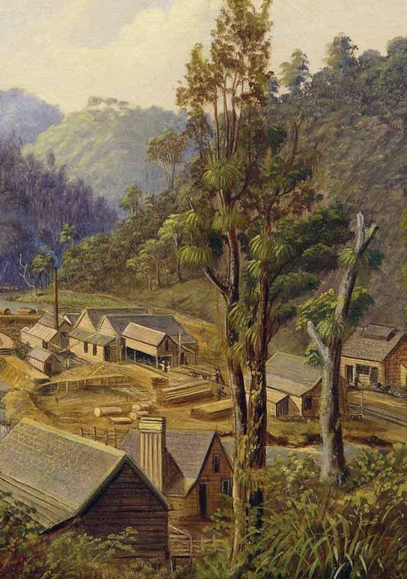
13In its heyday the Whatipu Mill was the shop and 20 worker’s cottages (Figure 14).
focal point of a large community of over There was also a school for local children
one hundred people. The mill itself had a and a small post office sited on the wharf
manager’s office, a store, a blacksmith’s at Paratütai.
Bush Mill, Whatipu, West Coast, Charles Blomfield 1880. Auckland Art Gallery Toi ö Tämaki Figure 14
14The Parara Express
(From The Waitäkere Ballads of John T. Diamond, 1978)
From the timber mill at Kiri to the wharf at Paratu
I rode the Parara Express way back in 82
Bearded Jan a Dutchman was the driver on this trip
He said he’d take no passengers but I bribed him with a tip.
I heaved my pikau in the tucker box and clambered in on top
And with just the faintest whistle the Parara Express was off.
Underneath the coastal cliffs, through a tunnel rather low,
Then over miles of ironsand dunes was the way we had to go.
At a tunnel through a headland we made the scheduled stop
While Jan lowered down the smoke stack so it wouldn’t get knocked off.
Getting near to Päraraha, old Jan now throttled down
For the stream is crossed on trestles full 12 feet above the ground.
We clattered past the siding that once was Bill Foote’s Mill
Now just a blackened ruin ‘mid charred trees beneath the hill
Chugging slowly round the headland to the ironsand dunes once more
The track is built on trestles six chain back from the shore.
Jan always ran the loco full speed along this line
But from Windy Point to Whatipu was where he lost some time.
The waves that break against the track can lift and twist this length
Although ‘tis built on trestles triple braced to give them strength.
Moving slowly neath the cliffs past caves both deep and dark
Jan stopped beside a waterfall to fill the water tank.
Three times he blew the whistle the blasts echoing round the bay
To let the wharfmen know the Express was on its way.
So on this fine day in August of 1882
The Parara Express pulled in at the wharf at Paratu
Here the brig ‘Wild Duck’ was waiting to sail out with the tide
So I took a passage on her bound for the goldfields down near Clyde.
15Nicholas and Matilda Gibbons (nee Laurie), Gibbons Family Collection Figure 15
The Gibbons Homestead 1870 remained at Whatipu with his wife Laura
(nee Williams). The Gibbons boys all
Another important focal point for the Whatipu remained involved in the timber milling
Mill community was the Gibbons homestead industry. Ebenezer Gibbons became well
(Figure 16) constructed by Mill Manager known as a designer and builder of timber
Nicholas Gibbons in 1870. This building is driving dams, while Bob Gibbons was
now at the centre of the complex known regarded as one of the most skilled kauri
as ‘Whatipu Lodge’. Here Nicholas and his bushmen of the period.
wife Matilda (nee Laurie) (Figure 15) raised
eight children, six boys and two girls, while A Subsistence Lifestyle
also running a small farm supplying meat
The closing of the mills on the Waitäkere
and vegetables to the mill. They farmed their
coastline in the late 1880s signaled a quiet
own land and some of the Auckland Harbour
period in Whatipu’s history, with the Gibbons
Board land that had been set aside for the
family barely making a living from milling
Pilot Station in 1853. When the Whatipu
flax and farming livestock. In the late 1890s
Mill changed ownership in 1877, Nicholas
Nicholas and Matilda Gibbons retired to
Gibbons gave up his position as manager,
Weymouth and the farm was taken over by
although he and his family continued to live
Fred and Laura Gibbons. They now lived
in the homestead. Nicholas carried on doing
in isolation at Whatipu, and continued to
timber milling work throughout the Waitäkere
struggle to survive economically on their
Ranges, and for a time operated a small flax
small farm property that was physically cut
mill at Päraraha.
off from the Auckland market. Whatipu still
By the end of the nineteenth century the had no access road and the steamer Weka
Gibbons children had left home to marry, now only called at Whatipu once a fortnight.
to attend school at Weymouth, or to seek The Gibbons family was totally reliant on the
work elsewhere. Only the second son Fred food that they grew and the resources that
they were able to get from the sea.
16Family Tragedy
Times were certainly tough for Fred and
Laura and their eight children, as their
grandson Bruce Harvey describes –
“At one time in the early years of the twentieth
century, when Fred and Laura Gibbons had a
young family, all eight of their children
contracted the dreaded childhood infection
diphtheria... At Whatipu there was no doctor or
medical help and the parents were desperate.
Fred took the worst affected children in a
flat bottomed dinghy, and rowed them to
Cornwallis where they proceeded by cart and
boat to the hospital at Auckland. Apparently he
kept a fire burning aboard the boat on a piece
of corrugated iron to try to keep the patients
warm. He had to battle against the tide and the The Gibbons family by the Whatipu Homestead
journey took 14 hours. One of the children died c.1905 (Carrie Woodward photo).
on the journey and another died in hospital the Waitäkere Library and Information Services Figure 16
following day.” (B. Harvey 2001:126)
WHATIPU – A HOLIDAY PLACE After timber milling ended in 1921 and the
tramline was lifted, the cottages became
The Gibbons family and the development vacant, and the Gibbons family became
of ‘Whatipu Lodge’. almost totally reliant on revenue from holiday
makers staying at Whatipu Lodge. Fred and
For the last hundred years Whatipu has
Laura Gibbons were helped in running the
become best known as a magical place for
Lodge by their three daughters Helen (Nel),
relaxed family holidays and fishing. Fred and
Dorothy (Dot) and Laura (Pops), and their
Laura Gibbons had provided accommodation
older sons Roy and Fred who had returned
for visitors in their homestead from the
safely from World War I. In relation to this
1890s. When timber milling resumed at
period Fred and Laura’s grandson Bruce
Karekare in 1906, and Piha in 1910, the
Harvey wrote,
coastal tramway was rebuilt and there was a
significant increase in the number of timber “In the early 1920s the accommodation house
workers and visitors arriving at Whatipu. was in full swing. The Gibbons family supplied a
To cater for the growing number of people full service to their guests, and made a speciality
seeking accommodation, Fred Gibbons of cooking any fish that were caught by their
built a dwelling for his family behind the old visitors. Whatipu increasingly became an
exciting and interesting place to stay and with
homestead which was now used for paying
the road completed in the mid 1920s people did
guests. He also built a new dining hall and
not have to depend on irregular sea transport...
kitchen, and a row of bunkhouses (Figure 17) courting couples undertook adventurous
on either side of the homestead. These were activities, such as fishing or hunting wild pigs.
used to cater for holiday makers and single Dances and social activities were often held in
workers from the timber tramway and wharf. the large cave (Figure 21), about half a kilometre
The complex became known as ‘Whatipu along the coast to the north of the lodge. The
Lodge’. Fred Gibbons also leased out the cave was lit and festooned with ribbons, and an
remaining mill cottages located in the lower accordion band supplied the music. There was a
Whatipu Valley to married men employed on wooden dance floor, which is probably still there
under the sand. The twenties were a time of
the tramway and at Paratütai Wharf.
gaiety and young people’s frolics at Whatipu.”
(B. Harvey 2001:136-138)
17Holiday makers at Whatipu Lodge, Labour Weekend 1924. On the far right is Stuart Armstrong.
Little would he have realized then that his grand daughter Alison Anderson would be a licencee
of the Lodge 80 years later. Alison Anderson family album Figure 17
With their children now married and working “happy times and memories at Whatipu,
away from home, Fred and Laura Gibbons swimming with their surf boards, walking and
made the difficult decision in 1929 to sell tramping to Päraraha valley and horse riding...
The sisters other memories include watching
Whatipu Lodge and the adjoining farm
steamers forging their way through the bar on
property, to give up the lease of the
their way to New Plymouth and men servicing the
Auckland Harbour Board land, and to retire lighthouse on the ocean side of Paratütai Island...
to Weymouth. They remember people from all over the World
staying at Whatipu.” (B. Harvey 2001: 144-145)
The new owners of Whatipu Lodge were
John and Constance (Winnie) Douglas. Figure 18
At the beginning of the major economic
depression of the 1930s, and with nine
children, John and Winnie had made a brave
decision to leave Auckland City to start a new
life at remote Whatipu. They were to stay at
Whatipu for three years during which time
they installed septic tanks and shifted the
former Post Office building from Paratütai
Wharf to the Lodge and converted it into a
toilet block. They continued to operate the
Lodge as visitor accommodation and to farm
200 sheep and 30 cows. The Douglas sisters
remembered,
Whatipu railway ruins, Ron Stephens Album
18The Farley Era forward to dinner. The evening meal was formal
and we all changed into clean and neat things.
In 1932 Whatipu Lodge was sold to the On the table was a white starched, meticulously
ironed tablecloth, napkins folded in mitre style
Farley family who had been operating a
and silver cutlery. The menu was varied but often
guesthouse at Karekare from 1900.
delicious fish soup (thick and milky), fish, or roast
‘Whatipu House’ (Figure 23), as they called beef or mutton and vegetables and then a desert
it, was managed for fifteen years by Wally consisting of guavas with lashings of whipped
Farley and his wife Florence. They put in a cream or a steamed pudding...After dinner we
tennis court and generally tidied the place would go for a walk or sit by a warm fire in the
up to cater for the growing number of sitting room of the old lodge and play snakes and
visitors arriving at Whatipu as the economic ladders and jigsaws or read. The lights of the
depression ended. Ailsa McElwaine (nee generator would go out at 9.00 p.m. but we had
Harvey) a granddaughter of Fred and Laura candles by our bedsides if need be. The holidays
at Whatipu are still a treasure in our minds.”
Gibbons recalled wonderful childhood
(B. Harvey 2001: 151)
holidays at Whatipu House in this period -
“We, as children, would have lots of interests,
To the west of ‘Whatipu House’, in what is
including catching minnows or tommy cods in now the campground, was a small group of
the stream, rolling and sliding down the sandhill holiday cottages that had been built from
with a toboggan, building sand dams and former mill workers cottages associated
diverting the water, or playing tennis. Sometimes with Whatipu Mill and the old Whatipu
we would take torches and candles to explore school building. Other cottages were built
the caves, a great adventure! We also fished later as holiday homes and they remained
with our parents off the wharf...In those days Dad on the former Auckland Harbour Board land
would catch snapper off Cutter Rock – today sand
until 1984. Of the original cluster of holiday
surrounds this rock for hundreds of metres...Each
cottages only ‘Liebergreen Cottage’
day was so full of fun and adventure. We enjoyed
all the meals as one does on holiday and looked
(Figure 20) remains.
Figure 19
Launch Outlaw leaving Paratütai Wharf, Whatipu c.1920, Waitäkere Library and Information Services
19Liebergreen Cottage
Around 1922 holiday-makers Bert and Anne Jones (nee Cowley) purchased two of the
old Whatipu Mill worker’s cottages from Fred Gibbons. Bert used horses to drag the
huts on rollers to a new site to the west of the Lodge and joined them together to form a
holiday bach (Figure 20) on land leased from the Auckland Harbour Board. The cottage
was enjoyed by Bert and his descendants for 40 years. In 1964 it was sold to Christian
and Yvette Liebergreen who enjoyed holidays in it for 20 more years. In 1984 ownership
of ‘Liebergreen Cottage’ transferred to the Auckland Regional Authority (ARA).
Although modified over the years, the cottage retained its basic original fabric as a mill
worker’s cottage, and its historic significance was recognized by the ARC. From 1984
the cottage has been used as temporary accommodation by park rangers, pest control
contractors and research students. In 2003 the ARC completed a conservation plan for
the cottage which is progressively being conserved by the Council.
Figure 20
In 1947, after a difficult time running Whatipu including a billiard table, and introduced
House during the war years, Wally and new linen and crockery. Mr. Gibson had the
Florence Farley decided to sell the property grand dream of turning ‘Whatipu Lodge’ into
and to retire. Between 1947 and 1950 the a high class guesthouse with silver service
lodge was owned and operated by an and waiters, but visitors to Whatipu wanted
English public school educated man Austin something far more casual. Bookings fell
Gibson. He built the present manager’s away and the Lodge soon became neglected
accommodation, installed new furniture, and derelict.
20Phil Sharp and Whatipu group of loyal clients who stayed at Whatipu
Lodge 1950-1984 regularly. The enterprise also benefited from
the custom of a number of ships masters
Whatipu Lodge was to be managed by and four Auckland QCs who brought the
a colourful character Phil Sharp for the Lodge welcome publicity.
remarkably long period of thirty four years.
Phil Sharp had been a clothes designer and
gentlemen’s tailor who had suffered a serious
leg injury during the North African campaign
of World War II. When he took over the
Lodge, it, and its surroundings were in very
poor shape. Phil poured his energy into the
enterprise, clearing gorse from right along
the Whatipu Road, upgrading the telephone
link, repairing the lodge buildings, and
upgrading the water supply. He also installed
the ‘100 man’ stove from the old Upper Huia
Dam camp in the kitchen. Phil leased the
Harbour Board Endowment that included the
large and growing coastal sand dune area.
He planted sand binding plants on the dunes,
although his large herd of cattle grazed them
and the surrounding bush heavily. Phil Sharp
maintained the Lodge as a basic wilderness
holiday establishment based around a large Auckland Tramping Club at the Giant Cave,
Whatipu, c. 1932, Waitäkere Library
and Information Services Figure 21
Figure 22
Te Ipu Kura ä Maki Taua
(nee Whareiti)
After the Hikurangi Block Crown purchase
of 1853 Te Kawerau ä Maki were confined
to the Piha and Waitäkere (Bethells Beach)
Native Reserves, although they still visited
and fished at Whatipu regularly. The last
member of Te Kawerau ä Maki to live
permanently at Whatipu was Apiata Te
Aitu who lived there until around 1880.
Members of the tribe have continued to
maintain kaitiakitanga or guardianship
over Whatipu from that time. Te Ipu Kura
ä Maki Taua was one such guardian from
the early 1900s until her death in 1968.
The Kura Track in the Whatipu Valley is
named after her. Te Ipu Kura ä Maki Taua (nee Whareiti),
Te Kawerau ä Maki Tribal Collection
21Whatipu House Advert., Weekly News, 1936, Waitäkere Library and Information Services Figure 23
The Auckland Regional Authority (ARA) before daylight and smoked twenty-seven fish
took over management of the Centennial for distribution to their neighbours and friends.
Memorial Park, including the land As a boy in 1935 he, with Jack Lawrence, had
hunted wild pig and caught fish at Whatipu,
surrounding Whatipu, in 1964. In 1971 the
having earlier ridden on horseback all the way
ARA was given a lease over the former AHB
from Glen Eden.” (B.Harvey 2001: 152)
Whatipu Endowment land which included
Whatipu Lodge. The Authority renewed the Mary and Neil Roberts 1984-2000
lease with Phil Sharp in 1979, although the
leased land associated with the Lodge was Mary and Neil Roberts were well qualified
reduced to 15 hectares, and cattle were to run an isolated holiday establishment
restricted to the lower Whatipu Valley. The like Whatipu Lodge, as Neil was a diesel
three remaining cottages located to the west engineer with farming experience, and
of the Lodge were also given separate leases Mary was a social worker and a trained
for ten years. The ARA Chief Ranger was nurse. In 1984 all of the remaining leased
Bill Beveridge who set about developing and cottages were removed except for the
upgrading walking tracks in the area. Bill historic Liebergreen Cottage. The Lodge was
has now enjoyed a 72 year association with again renovated and painted in its original
Whatipu and the Lodge, and has very fond dark colours, and the surrounding grounds
memories of the place. were upgraded. The road out to Huia had
now improved and the Lodge received
“He remembers having a holiday with his friend
economically beneficial publicity as a result
Ivor for two weeks in 1979, and during one night,
catching ten snapper in a ‘hole’ out from Päraraha
of the TV programme presented by the
valley. They caught twenty fish the next morning actress Annie Whittle.
22“Whatipu drew trampers and fishing people in The Council commissioned the production
increasing numbers...Several films using Whatipu of conservation plans for Whatipu Lodge
as a location were made during the 1980s and and the adjoining Liebergreen Cottage.
1990s, including with the American actress Cybil
The considerable heritage value of the
Shepherd and another with the New Zealand
buildings was confirmed and the ARC
actor Ian Mune. At one time the whole cast of
the New Zealand television series Shortland
embarked on a comprehensive building
Street stayed at the lodge during the shooting conservation programme for the Lodge and
of particular scenes in the soap drama. In this Liebergreen Cottage 2001-2007. A small
period there was also real drama at Whatipu. hydro electric power generation plant was
Several drownings and a murder occurred in also installed and a new ablution block
the area.” (B.Harvey 2001: 154) constructed.
WHATIPU IN RECENT TIMES The Lodge was leased as a going concern
to Alison Anderson and Marnie Hunter
Whatipu Lodge remained under the (Figure 24) in April 2001. They have continued
management of Neil and Mary Roberts until the tradition of providing a relaxed and high
May 2000. The ARC had taken control of quality experience for those who stay at
the 1000 acre (404 ha) Auckland Harbour Whatipu Lodge and the campground.
Board Endowment in 1989, and in 2002 Along with Bruce and Trixie Harvey, Alison
the Crown declared the 820 hectare Whatipu and Marnie have also been at the centre
Beach sand wilderness to be a Scientific of the community volunteer group ‘Friends
Reserve with management vested in the of Whatipu’ founded in 2002. This group
ARC. After considerable public consultation promotes Whatipu’s natural and cultural
the Council decided to maintain Whatipu heritage. It works with the ARC to undertake
Lodge as a short-stay residential lodge under restoration plantings of native species,
licence, and to manage the Whatipu area as to enhance protection for shore birds
a remote experience wilderness and wildlife breeding on the adjoining coastline, and to
protection area. promote the rich human history of the area.
Marnie Hunter and Alison Anderson at Whatipu Lodge, 2005 (Jan Young photograph) Figure 24
23Community planting day, Whatipu, July 2005, Auckland Regional Council Figure 25
In 2001 Bruce Harvey the great grandson Auckland people have a very strong sense of
of Whatipu pioneers Nicholas and Matilda the environment and our history. Many groups
Gibbons published his wonderful local history such as the Te Kawerau people, Waitäkere
(Ranges ) Protection Society, the Forest and Bird
entitled Whatipu – The Story of Whatipu and
Society, West Auckland Historical Society and the
Early Huia. In it he writes,
Auckland Regional Council, help to voice
the desire of people to protect our heritage.
“In the hills and valleys of Whatipu today the
The future looks assured for this unique, historic
forest is once more resplendent, the coast
and beautiful place.” (B. Harvey, 2001:160-161)
looks just as dramatic as in the past. The lodge
remains as an historic building to remind us
This booklet was written by Graeme Murdoch.
of the past, and hopefully to appreciate better
The author would like to acknowledge the significant
the lessons of history. One wonders what the
contribution from Bruce Harvey and his publication
future is for Whatipu – the present generation is
Whatipu – the Story of Whatipu and Early Huia, 2001.
generous in its desire to preserve the past and
the environment. New Zealanders and West
‘Our History’ is a booklet series produced by the Auckland Regional Council (ARC).
It is part of a cultural heritage initiative established to provide information about
local history and regionally significant historic resources.
For further information:
• Contact the Auckland Regional Council ph: 09 366 2000
• Visit the Auckland Regional Council website www.arc.govt.nz
For further reading:
• WHATIPU, the story of Whatipu and early Huia, B.Harvey 2001
• Waitäkere Ranges, Ranges of Inspiration, B. & T. Harvey (ed.) 2006
• The Orpheus Disaster, T. Fairburn 1987
• Waitäkere Kauri, J.T Diamond & B.W. Hayward 1980
• Wing of the Manukau, T.B. Byrne 1991
24 www.arc.govt.nzWhatipu Timeline
1929 the Gibbons family
ownership of Whatipu Lodge ends.
1200s Mäori
occupation of
Whatipu begins. 1926 road access to
Whatipu is created and 1929-32 the Douglas family
launch services are manages Whatipu Lodge.
reduced to weekly.
1932 the Farley family take over
Whatipu Lodge for the next fifteen
1921 timber milling ends and years. The tennis court is built.
Liebergreen Cottage is created
from two mill workers huts.
1906 timber milling resumes 1950 Paratütai Wharf is
demolished. Phil Sharp takes over
Mid 1400s the Tainui canoe and ‘Whatipu Lodge’ is created.
Whatipu Lodge and a telephone
arrives and the Ngäoho
line is completed to Whatipu.
people settle in the area.
1886 the first phase
of timber milling ends.
1971 the AHB Whatipu Endowment
land is now managed by the ARA.
Mid 1600s Te Kawerau 1870 the Gibbons Homestead
ä Maki settle in the area. is built by Nicholas Gibbons.
1868 the Gibbons family 1984 management of Whatipu
commence construction Lodge is taken up by Neil and
1700s conflict with Ngäti of the Whatipu Sawmill. Mary Roberts until 2000.
Whätua – Te Raupatu
Tïhore and then peace.
1863 the wreck of the HMS
Orpheus. The Paratütai Signal 2000-2002 conservation plans
Mast is chopped down by are completed for Whatipu Lodge
Waikato Mäori. and the Liebergreen Cottage and
restoration commences.
1820 visit of Rev. 2001 Bruce Harvey’s history
Samuel Marsden to of Whatipu is published.
the Manukau Heads.
1853 the Signal
and Pilot Station
established at Whatipu.
1826 The Musket Raids. 2002 Alison Anderson and Marnie
Hunter take over as licencees of
Whatipu Lodge. The Whatipu sand
1835 Te Kawerau ä Maki 1853 Crown Purchase of accretion is declared a Scientific
return to Whatipu under the the Hikurangi Block and Reserve by the Crown and its
protection of the Tainui Ariki the creation of Native management is vested in the ARC.
Te Wherowhero. Reserves at Piha and
Waitäkere (Te Henga).
2002 Friends of
Whatipu Inc. formed.
1845 Te Kawerau ä Maki Today
converted to Chistianity.You can also read