Why the Nebra Sky Disc Dates to the Early Bronze Age. An Overview of the Interdisciplinary Results
←
→
Page content transcription
If your browser does not render page correctly, please read the page content below
Archaeologia Austriaca, Band 104/2020, 89–122
© 2020 by Österreichische Akademie der Wissenschaften, Wien                                                                                      89
doi: 10.1553/archaeologia104s89

Why the Nebra Sky Disc Dates to the
Early Bronze Age. An Overview of the
Interdisciplinary Results

Ernst Pernicka
Jörg Adam
Gregor Borg
Gerhard Brügmann
Jan-Heinrich Bunnefeld
Wolfgang Kainz
Mechthild Klamm
Thomas Koiki
Harald Meller
Ralf Schwarz
Thomas Stöllner
Christian-Heinrich Wunderlich
Alfred Reichenberger

Abstract                                                                  have been on the Mittelberg near Nebra. By contrast, they assert that
It is not unusual that archaeological finds come under renewed scru-      the Sky Disc should be typologically dated to the Iron Age. It can
tiny. This is actually an important part in the progress of scientific    be shown that their arguments are based on a distortion of the evi-
research. All the more so when important and ground-breaking dis-         dence derived both in the court trial and by scientific analyses. They
coveries are involved, like the Nebra Sky Disc, which is listed among     combine their proposal with a superficial typological discussion of
the UNESCO “Memory of the World”. However, in most cases a                the image displayed on the Sky Disc. As this overview demonstrates,
new assessment is based on new data or insights. None of this is pre-     through interdisciplinary studies it is possible to determine the ori-
sented in a recently published article by Gebhard and Krause (2020).      gin and composition of the Nebra hoard with the greatest possible
Instead, their argument is based on early published and unpublished       certainty. This determination was based on results from sediment
material, which is used and cited selectively and ignores a substantial   attachments, the chemical concentrations of gold and copper in the
number of subsequent publications. Since the Nebra Sky Disc is a          geological subsoil of the findspot, astronomical references, as well as
unique find that was not recovered during a controlled excavation,        an analysis of the traces left by the looters, police investigations, and a
it can neither be dated by traditional typological methods nor prima      comprehensive confession by the offenders, which has confirmed the
facie by its appearance. Moreover, there is no scientific method yet      independently obtained archaeological and scientific observations.
available to date copper alloys exactly, so that the date suggested in
the original publication was established by reconstructing the find       Keywords
context and by analysing the accompanying finds that are typologi-        Nebra Sky Disc, find context, Early Bronze Age, authenticity, ar-
cally and radiocarbon dated to around 1600 BC. The find location on       chaeology, archaeometry, soil pedology/geology.
the Mittelberg was excavated in great detail and a number of scientific
analyses confirmed the testimony of the looters in a court trial that     Zusammenfassung – Warum die Himmelsscheibe von Nebra in
the Sky Disc had been buried there together with the accompanying         die Frühbronzezeit datiert. Überblick über die interdisziplinären
finds. These analyses also disproved an earlier claim that the Sky Disc   Ergebnisse
was a modern fake. This allegation is not repeated by Gebhard and         Es ist nicht ungewöhnlich, dass archäologische Funde einer erneuten
Krause (2020) but they do use similar arguments for their claim that      Prüfung unterzogen werden; dies ist eigentlich ein wichtiger Teil im
the Sky Disc was not found together with the hoard and may not even       Fortschritt der wissenschaftlichen Forschung. Umso mehr gilt das,
90                                                         Ernst Pernicka et al.

wenn es sich um wichtige und bahnbrechende Entdeckungen han-            a controlled archaeological excavation, doubts have occa-
delt, wie die Himmelsscheibe von Nebra, die in das UNESCO-Welt-         sionally been raised concerning the authenticity of the Sky
dokumentenerbe („Memory of the World“) aufgenommen wurde.
                                                                        Disc and if it was actually found together with the metal
In den meisten Fällen beruht eine neue Beurteilung jedoch auf neuen
Daten oder Erkenntnissen. Nichts davon findet sich in einem kürz-
                                                                        objects that undisputedly can be dated to the developed cen-
lich veröffentlichten Artikel von Gebhard und Krause (2020). Statt-     tral European Early Bronze Age around 1600 BC.1 These
dessen stützt sich ihre Argumentation auf früh veröffentlichtes und     doubts were thoroughly rebutted in a judicial trial against
unveröffentlichtes Material, das selektiv verwendet und zitiert wird    the looters and the antiquities dealers at the Regional Court
und eine beträchtliche Anzahl von Folgepublikationen ignoriert. Da
                                                                        in Halle in 2005 and, after completion of the appeals pro-
es sich bei der Himmelsscheibe von Nebra um einen einzigartigen
Fund handelt, der nicht bei einer kontrollierten Ausgrabung gebor-      cedure, in a scientific article.2 Since then a number of fur-
gen wurde, kann sie weder mit traditionellen typologischen Metho-       ther investigations have widened and consolidated the cul-
den noch prima facie nach ihrem Aussehen datiert werden. Zudem          ture-historical setting of the Nebra Sky Disc.3 Most of the
gibt es noch keine wissenschaftliche Methode zur exakten Datierung      results of these investigations are widely scattered in differ-
von Kupferlegierungen, so dass die in der Originalpublikation vor-
                                                                        ent specialist journals, conference proceedings, and books,
geschlagene Datierung durch die Rekonstruktion des Fundkontextes
und durch die Analyse der Beifunde, die typologisch und radiokoh-       because the ramified research comprised many different
lenstoffdatiert um 1600 v. Chr. liegen, ermittelt wurde. Der Fund-      disciplines. It is not possible and was never our intention
ort auf dem Mittelberg wurde sehr detailliert ausgegraben und eine      to define an endpoint of the research on the Sky Disc, but a
Reihe von wissenschaftlichen Analysen bestätigten die Aussage der       volume including a summary of the insights gained over the
Raubgräber in einem Gerichtsverfahren, dass die Himmelsscheibe
                                                                        last fifteen years is in preparation.
dort zusammen mit den Begleitfunden vergraben lag. Diese Analysen
widerlegten auch eine frühere Behauptung, dass die Himmelsscheibe           This overview was triggered by a recently published
eine moderne Fälschung sei. Diese Behauptung wird von Gebhard           claim that it is more likely that the Sky Disc was not part of
und Krause (2020) zwar nicht wiederholt, aber sie verwenden ähnli-      the Nebra hoard and, based on stylistic arguments, should
che Argumente für ihre Behauptung, dass die Himmelsscheibe nicht
                                                                        be dated to the Iron Age.4 It is also mentioned there that the
zusammen mit dem Hort und vielleicht nicht einmal auf dem Mit-
telberg bei Nebra gefunden wurde. Stattdessen behaupten sie, dass
                                                                        new assessment was made “on the basis of sources that are
die Himmelsscheibe typologisch in die Eisenzeit datiert werden soll-    more difficult to access” and that the “underlying sourc-
te. Es lässt sich zeigen, dass ihre Argumente auf einer Verzerrung      es were published only insufficiently or not at all”. As it
der sowohl im Gerichtsverfahren als auch durch wissenschaftliche        turns out, these sources are partly out of date and represent
Analysen gewonnenen Beweise beruhen. Sie verbinden ihren Vor-
                                                                        the state of the art at the beginning of the investigations of
schlag mit einer oberflächlichen typologischen Diskussion des auf
der Himmelsscheibe dargestellten Bildes. Wie dieser Überblick zeigt,    the Nebra hoard. Nevertheless, Gebhard and Krause pres-
ist es durch interdisziplinäre Studien möglich, Herkunft und Zusam-     ent an interpretation of the find context and the associated
mensetzung des Nebra-Horts mit größtmöglicher Sicherheit zu be-
stimmen. Diese Bestimmung basiert auf den Ergebnissen von Sedi-
mentanhaftungen, den chemischen Konzentrationen von Gold und            1 This began with a letter from Peter Schauer to the ‘Frankfurter All-
Kupfer im geologischen Untergrund der Fundstelle, astronomischen        gemeine Zeitung’ on 30.11.2004, followed by Schauer 2005a, using
Referenzen sowie einer Analyse der von den Raubgräbern hinter-          almost identical arguments against the Mittelberg site as now. – Com-
lassenen Spuren, polizeilichen Ermittlungen und einem umfassenden       pare Gebhard, Krause 2020.
Geständnis der Täter, das die unabhängig gewonnenen archäologi-         2 Judgement of the Regional Court Halle 2005: LG Halle 2005. –
schen und wissenschaftlichen Beobachtungen bestätigt hat.               Pernicka et al. 2008.
                                                                        3 Two conference volumes, nine dissertations and dozens of articles
Schlüsselbegriffe                                                       on the Sky Disc and its cultural environment have emerged from the
Himmelsscheibe von Nebra, Fundkontext, Frühbronzezeit, Authen-          DFG research group FOR550 alone: Meller, Bertemes 2019, 15–19
tizität, Archäologie, Archäometrie, Bodenkunde/Geologie.                with a bibliography of the articles published since 2004 within the
                                                                        respective project groups of the FOR550. – See also Bertemes 2019,
                                                                        21–32.
                                                                        4 Gebhard, Krause 2020. – Almost identical arguments were
1. Introduction
                                                                        published by the same authors in a book on alleged Middle Bronze
The Nebra Sky Disc is one of the most important archaeo-
                                                                        Age gold and amber finds from Bernstorf, Freising district, Bavaria
logical finds of the past century. It is widely accepted that           (Gebhard, Krause 2016), which strangely enough gives the Nebra
it displays the world’s earliest known concrete representa-             Sky Disc a conspicuously wide scope. These arguments do not seem
tion of astronomical phenomena. Its cultural significance is            to have been given much consideration among relevant specialists.
                                                                        The Bernstorf finds have meanwhile been exposed as forgeries, see
also reflected by its inclusion into the UNESCO “Memo-
                                                                        Pernicka 2014b and the following consistently negatively assessed
ry of the World” register in June 2013. However, since the              reviews of Gebhard, Krause 2016: Ernée 2017. – Harding,
Sky Disc, together with a number of accompanying metal                  Hughes-Brock 2017. – Jung 2017. – Pernicka, Wunderlich 2017.
objects known as the Nebra hoard, was not recovered in                  – Reichenberger 2017. – Weiss 2017.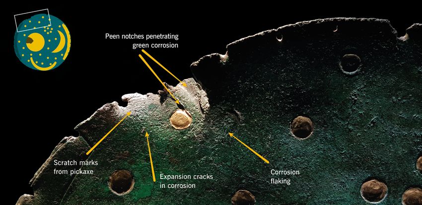
Why the Nebra Sky Disc Dates to the Early Bronze Age. An Overview of the Interdisciplinary Results 91
Berlin
Magdeburg
Nebra
Munich
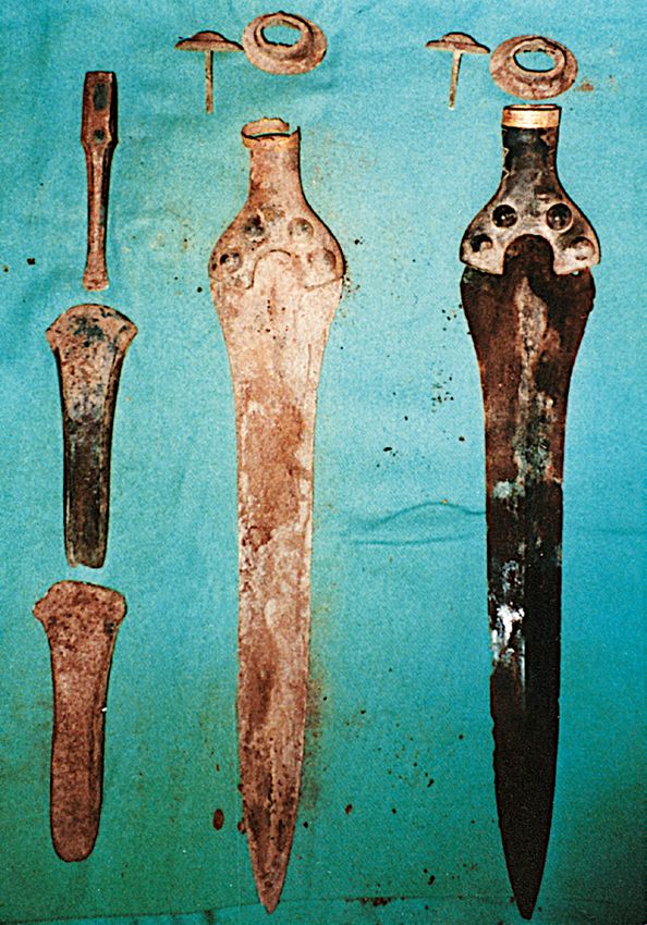
Fig. 1. The Nebra hoard with the Sky Disc, two swords, two axes, one chisel and Fig. 2. Map with the Nebra site
two arm spirals after restoration (Photo: J. Lipták, Munich). (B. Janzen, LDA).
scientific analyses which is essentially a rehash of the argu- 2. The Find Context of the Nebra Hoard
ments put forward by Peter Schauer,5 with the important On 4 July 1999, two looters discovered an Early Bronze
difference that the Sky Disc is no longer seen as a modern Age hoard on the Mittelberg hill near Nebra, Burgenland-
forgery but as an archaeological object from a different site kreis (Saxony-Anhalt), which consisted of two swords, two
that may be dated to the Iron Age. Three major arguments axes, one chisel, and two arm spirals as well as a bronze disc
are used for this interpretation, namely the divergent re- which was almost completely covered with adhering soil
ports of the two looters who uncovered the hoard, minor (Figs. 1–2, 12, 15). After the initial and improper cleaning
differences in samples of adhering soil on three objects of of this disc, an image consisting of gold inlays was revealed.
the hoard including the disc, and differences in the chemical A few days later, the looters sold the entire find to the first
and lead isotope compositions of the objects in the hoard. dealer. Almost three years later, the Sky Disc and other ob-
In the following, these arguments are dealt with in the jects from the hoard were recovered in a Swiss hotel and
same order. They resemble, as mentioned, the same argu- seized by the authorities. Subsequent police investigations
ments put forward to support an earlier allegation that the were able to track down the missing pieces as well as local-
Sky Disc was a modern forgery, which were effectively ising the findspot.
refuted in a comprehensive article in the ‘Archäologisches The discovery of the Nebra hoard with the Sky Disc,
Korrespondenzblatt’.6 Inevitably, these results must in parts its illegal excavation and later recovery by the authorities7
be taken up again, but new images and new arguments in the has been described in detail several times and need not be
light of more than a decade of research are presented. repeated here.8 The looters were convicted in a first court
trial and gave testimony in a second trial before the Regional
Court in Halle against the two antiquities dealers who last
had the hoard in their possession. In the course of the inter-
5 Schauer 2005a. – Schauer 2005b.
6 Pernicka et al. 2008. – Compare with the judgement of the Re- rogations, one of the looters, Mario Renner, cast doubt on
gional Court Halle 2005 (LG Halle 2005) and Riederer 2016, 307:
“I am convinced about the authenticity of the disc and the origin of
the disc in the Bronze Age because the scientific arguments presented 7 The disc was seized by the Basel police on 23 February 2002, i.e.
(the type of metal, the type of patina, the technological characteris- some two and a half years and not four years after its discovery as
tics, the results of the isotope and lead-210 analyses) have a conclusive suggested by Gebhard, Krause 2020, [1].
force that cannot be refuted” (published in German, translated by the 8 LG Halle 2005, esp. 6–18. – Meller 2010a, 24–31. – Schöne
authors). 2015, esp. 12–99. – Meller, Michel 2018, 24–51.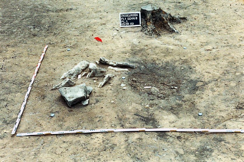
92                                                      Ernst Pernicka et al.

the narrative of his accomplice Henry Westphal in a book             Early Bronze Age swords and the other findings at different
which was written by two ghostwriters.9 He described both            locations within a short period of time.
the place of discovery and the composition of the hoard as
being made up of different finds. However, in court Renner           2.1. The Archaeological Excavation
himself described this book as a merely fictitious report in         The archaeological investigation of the looter’s excavation
which the find situation is not authentically reported.              pit took place under the local supervision of Thomas Koiki
    The facts of the case were extensively and thoroughly            (State Office for Heritage Management and Archaeology
assessed by the 10th Criminal Chamber of the Halle Region-           Saxony-Anhalt in Halle, in the following: LDA) between 19
al Court, chaired by the presiding judge, Judge Gester, who          August 2002 and 25 November 2002.16 The pit-like feature
concluded: “After a comprehensive review of all the evi-             which was the remnant of the looter’s activity was localised
dence, there was no doubt about the find location of the Ne-         according to information provided by the looters them-
bra Sky Disc.” In particular, the court paid close attention         selves and (independently of them) by one of the dealers.
to the credibility of the witnesses Westphal and Renner and          It was still recognisable as a shallow depression and located
came to the conclusion: “...Based on the impression gained           directly next to a charcoal kiln at the incipient northwestern
of Westphal during the hearing of 03.06.2005, which last-            slope area about 50 m from the centre of an Iron Age en-
ed several hours, the chamber had no doubt that Westphal             closure on the top of the Mittelberg. The localisation of the
faithfully reported the location of the hoard of Nebra.” The         findspot required little effort because of the charcoal kiln, a
“dubious insinuations about a possibly completely differ-            hunter’s stand, and a tree mark made by the looters.
ent find situation” by Renner were, however, judged by the                Although a final publication of the excavation report is
court to be untrustworthy.10                                         still in preparation, a plan and two sections with accompa-
    It is difficult to understand why Gebhard and Krause             nying information and photos have already been published
rely on such grey literature as the booklet published by Ren-        several times (Fig. 3).17 This published information should
ner as a key witness to support their own interpretation of          actually be sufficient for any archaeologist to understand
the find context. Contrary to the conclusions reached by             the context of the find. The major difference in the interpre-
the court trial, they claim that the witness Westphal was            tation of the find context is the thickness of the humus layer.
influenced by “suggestive questions by archaeologists in-            Gebhard and Krause estimate it, based on Josef Riederer’s
volved”.11 Based on this assumption, for which no new evi-           suggestion, to have been 15 cm (Fig. 4).18 However, the loot-
dence is presented, the authors cast doubt on the credibility        ers always spoke of a 3–5 cm-thick humus layer,19 consistent
of this testimony. Instead, they claim that the “original traces     with the situation found at the Sky Disc’s findspot (Fig. 5).
of diggings and damage to the disk during its retrieval”12 are       A thicker topsoil deposit can indeed be found a few metres
contradictory. Firstly, they maintain that the shallow depth         away from the findspot. However, this is the result of a me-
and the alleged partial storage in humus in which the disc           dieval to early modern charcoal kiln located here (Fig. 6).20
was found should have caused differences in the corrosion                 After the removal of the forest soil, which varied in thick-
of the Sky Disc. The information provided by the looters in          ness between approx. 6 and 8 cm in the immediate undis-
this regard must, therefore, be incorrect.13 The differences         turbed surroundings, a brown to dark grey-brown, almost
in the corrosion can, however, be explained by the vertical          circular discolouration (4b) with a diameter of 90–100 cm
position in the ground (see section 3). Secondly, they claim         emerged in the first subsoil level (Bv horizon) (see Fig. 3).
that the damage to the Sky Disc was not caused by its im-            Within this feature there was a darker, round to oval core
proper recovery by the looters, but in two separate events           area (4a) filled with decaying foliage, small twig fragments
at widely different times.14 From this it was concluded that
the Sky Disc was either initially buried somewhere else or           16 The excavation has been published in Pernicka et al. 2008, 332–
possibly added to the Nebra hoard later.15 This would im-            334. – Meller 2010a, 35–45. – Meller 2013, 496–499.
                                                                     17 Pernicka et al. 2008, 332–334, 333 and Figs. 1–2. – Meller 2010a,
ply that the looters found the disc as well as a set of unique
                                                                     35–44, 36–37 and Figs. 4, 6. – Meller 2010b, 78–83. – Meller 2013,
                                                                     496–499, 498 and Figs. 5–6.
9 Renner [2005].                                                     18 Gebhard, Krause 2020, [4]. – Already stated in Gebhard,
10 LG Halle 2005, 21–23 (translated by the authors).                 Krause 2016, 30–31. – Riederer 2016, 309.
11 Gebhard, Krause 2020, [4].                                        19 This is correctly cited in Gebhard, Krause 2016, 27 and Geb-
12 Gebhard, Krause 2020, [2].                                        hard, Krause 2020, [4] with footn. 8 referring to “Trial minutes RA
13 Gebhard, Krause 2020, [4].                                        Thommen” (correct: Thom-Eben).
14 Gebhard, Krause 2020, [3–4].                                      20 Mentioned, for instance, by Pernicka et al. 2008, 332. – Meller
15 Gebhard, Krause 2020, [17].                                       2010a, 43, 37 and Fig. 6a.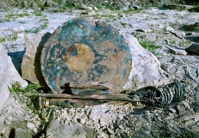
Why the Nebra Sky Disc Dates to the Early Bronze Age. An Overview of the Interdisciplinary Results                                                       93

                                                                                                      N

                                                                                                                                                    4c
                                                                                                           Stones – feat. 3/02

                                                                                                                                                   4b

                                                                                                                                                  4a

                                                                                                                         Feat. 4/02

                                                                                                                                                        1m

                                                                                                                                                                         a

                                                              E-W-Profile                                                                         N-S-Profile

Loo�ng Pit – feat. 4/02      C             B                               Profile – no. 30   E             B        Feat. 4/02                              y=1011.30
                                                                                                                                                            x=1023.47

                                                                                                                                                        x
                                     4a             4c                                                                                                      F
                                                                                                                                           Bv-horizon
                                                         Bv-horizon                                                              4b
                                                                                                                         4a                                     Pl. 2
       Stones – feat. 3/02            4b                                                         4c            4b

                                                                                                                                                                Pl. 3
                                               4d
                                                                                                                    4d

                                                     1m                                                                               1m                                b

Fig. 3. Archaeological documentation of the looter’s pit feature 4/02 on the Mittelberg near Nebra 2002. – a. Planum in a photo (left) and draw-
ing (right). – b. East-west section (left) and north-south section (right) in photo and drawing. The pit-like feature consists of three layers (4a–c).
The core (4a) consisted of fresh leaves, wood, and humus remains. The surrounding pit filling (4b) contained less recent organic components.
In contrast to the adjacent material of the humification horizon, the area around the pit (4c) had a brown colour. Below the pit, high copper and
gold concentrations could be measured in an undisturbed, banded clay layer (4d) (see Fig. 8). The stone packing east of the pit could be identi-
fied as a natural geological phenomenon (Meller 2013, 498 and Figs. 5–6).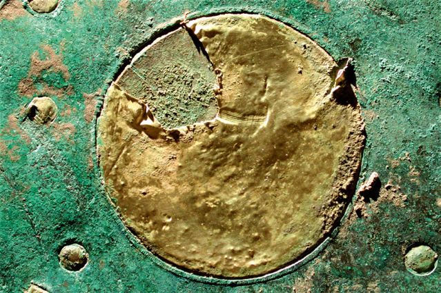
94                                                          Ernst Pernicka et al.

                                                                         subsoil horizon was discoloured to a brownish shade (4c).
                                                                         This irregular, shapeless feature had vague boundaries and
                                                                         measured about 2.50 × 0.80 m from south to north. Because
                                                                         it was only a few centimetres deep it was interpreted as being
                                                                         the result of the looter’s diggings.
                                                                              Immediately to the east of the findspot, stones were dis-
                                                                         covered which appeared to be tightly packed. At first this
                                                                         was treated as an anthropogenic feature but this interpre-
                                                                         tation had to be corrected in the course of the excavation
                                                                         work.21 Later it was found that this was a natural geological
                                                                         feature, among other things because of its contact with the
                                                                         bedrock and numerous frost cracks on the stone slabs.22
                                                                              The soil (4b) on the edge of the fill of the looter’s pit
                                                                         was altogether less humic than the core area (4a), reaching
                                                                         about 30 cm deep, and also contained less foliage and fewer
Fig. 4. On the excavation photo, which was made available to the         twigs. Moreover, the proportion of loamy sand was higher.
court by the LDA, Gebhard and Krause reconstructed the topsoil           As a result, the soil had a lighter hue and was partly mottled.
structure above the looters’ pit with a thickness of 15 cm (Gebhard,
                                                                         Occasionally, charcoal particles were found which proba-
Krause 2020, [3] and Fig. 2c). However, the thin humus layer had
already been removed when this photograph was taken. Even here
                                                                         bly derived from the adjacent charcoal pile. The remains of
it becomes visible that the schematic drawing (grey) lies entirely       leaves and twigs prove that the backfilling of the pit could
within the browning horizon of the section behind it. However,           not have taken place a very long time ago. The greatest depth
the thickness is augmented by the remains of a charcoal pile, which      of the feature is 60 cm below the top edge of the humus.
is why the black layer is actually thicker here (Gebhard, Krause
                                                                         The pit’s edge is very irregular, its contour is partly bulged,
2020, [3] and Fig. 2c).
                                                                         partly rounded, then again polygonal with short straight
                                                                         sections.
                                                                              During the excavation of the backfilled material from
                                                                         the southeastern part of the pit, the very irregular pit wall,
                                                                         which was interspersed with small pieces of sandstone,
                                                                         was carefully exposed. Some vertical, narrow, 3–8 cm-long
                                                                         longitudinal grooves were interpreted as possible traces of
                                                                         hammer blows. According to the investigations by the pub-
                                                                         lic prosecutor the hoard find was uncovered with a modified
                                                                         fire brigade pickaxe. The two most distinct impact marks
                                                                         were cast in plaster and thus preserved.
                                                                              Directly below the looter’s pit a brown to red-
                                                                         dish-brown, weakly banded, maximally 10 cm-thick, irreg-
                                                                         ular discolouration (4d) was found. The consistency of the
                                                                         sandy material corresponded to that of the C-subsoil ho-
                                                                         rizon. The banding was probably caused by the relocation
Fig. 5. The photograph shows the looters’ pit with the adjacent
                                                                         of clayey or humic material from the original prehistoric
stone packing from a different perspective. On the right edge of the
photo we see the northwestern section (see plan Fig. 6), which is
                                                                         feature, which had been completely destroyed during the
located opposite the charcoal pile on the southeastern section (see      looter’s ‘excavation’. Through this the former context could
Fig. 4). After removal of the foliage, the humus layer (Ah horizon)      be reconstructed at least indirectly.
measured only about 5 cm (red box) (Meller 2010a, 36 and Fig. 4,              Two soil sections were investigated, each at a distance of
adapted by B. Janzen, LDA).
                                                                         15 m from the findspot of the Sky Disc (soil profile KA 142a

and humic sand. This core feature had dimensions of about
                                                                         21 Still wrongly reported in Meller 2002, 18, but corrected in
45 × 56 cm. In the area surrounding the actual pit, the other-           Meller 2013, 498.
wise light-brownish yellowish material of the humification               22 Kainz, Klamm in prep.
Why the Nebra Sky Disc Dates to the Early Bronze Age. An Overview of the Interdisciplinary Results                                                         95

                                                                                                                            Feat. 4/02 – Loo�ng pit

                                                                                                                    4a
                                                                                                                    4b
                                                                                                                                                    Feat. 3/02 –
                                                                                                                    4c                              Stones

                                                                                                               4a = dark core area in 4b
                                                                                                               4b = backfilled loo�ng pit
                                                                                                               4c = shallow discoloura�on

                                                                                                                Legend
                                                                                                                                             Excava�on area
                                                                                                                                             Excava�on boundary
                                                                                                                                             Topographic mark
                                                                                                                                             District border
                                                                                                                                             1m – contour line
                                                                                                                                             Charcoal kiln
                                                                                                                                             Findspot Sky Disc
                                                                                                                                             Iron Age rampart
                                                                                                                                             Sampling points

                                                                                                                Ziegelroda /Wangen
                                                                                                                Merseburg-Querfurt district /Burgenlandkreis district
                                                                                                                Mi�elberg Excava�on 2002–2004
                                                                                                                Site plan (date 09/2004)
                                                                                                                Posi�on of the excava�on areas

Fig. 6. The location of the looting pit within the Iron Age rampart on the Mittelberg (feature 4/02, red circle). Southeast of the feature, the
remains of a medieval or early modern charcoal pile were documented. The sampling sites of reference samples for the determination of the
background concentrations of copper and gold in the local sediment are marked as red rectangles south of the looting pit (Meller 2010a, 37
and Fig. 6a).

and 142b).23 The soils are characterised by brunification and                   The observed thickness of the humic topsoil was 5 cm in
clay leaching (brown albeluvisols) and developed in lay-                    the neighbouring anthropogenically unaffected soil section,
ers of moderately silty to moderately loamy sand above                      corresponding to the find circumstances. Certainly, the pit,
sandstone. The clay-enriched horizons consist of sandy                      in which the disc was once buried, was refilled with the exca-
loam. The thickness of the layers above the bedrock var-                    vated soil, which consisted mainly of light-coloured subsoil.
ies between 45 and 65 cm. The fact that these layers are so                 Except for a small fraction of humus that was added during
thin is explained by early Holocene soil erosion, which is                  the refilling process, the material originally surrounding the
evidenced by the presence of relocated soil material in the                 disc consisted of the light-coloured subsoil, which, accord-
adjacent dry valleys. However, soil erosion and soil relo-                  ing to the photos taken shortly after the discovery, adhered
cation (section KA 142a) also took place after albeluvisol                  firmly to the disc.25 It can also be assumed that the Sky Disc
formation and brunification, which is the reason for the                    originally lay in the area of the clay leaching, the result of
near-surface location of the Sky Disc. If the Sky Disc had                  which was documented under the pit (feature 4d).26 Hence,
been re-embedded in the course of this soil relocation, it                  the Sky Disc was buried in a pre-existing brown albeluvisol.
would have been found lying horizontally.24                                 No traces of bleaching or leaching were observed within the
                                                                            topsoils and brown soil horizons. Thus, younger humic or
                                                                            clayey coatings could not form on the Sky Disc.
23  Kainz, Klamm in prep.
24  Its vertical position when found, but also the fact that it lay in an
artificial pit, contradicts the purported secondary position postulated     25   See Meller 2010a, 32 and Figs. 1a, 1c.
by Gebhard, Krause 2020.                                                    26   Koiki 2006, 8 and Fig. 13/4d.
96                                                            Ernst Pernicka et al.

    Subsequently, due to the slight slope and former erosive
types of land use (grazing, trampling etc.), a moderate and
small-area differentiated soil erosion took place. Also, the
Iron Age rampart on the Mittelberg was flattened due to
erosive processes.27 It can therefore be assumed that the disc
was initially buried deeper in the ground than it appeared
at the time of discovery, and would therefore certainly not
have come into contact with the thin ‘forest humus’ that was
newly formed on the surface of the terrain after embedding
and after later soil erosion.
    In summary, the testimony of the looters, the surface
quality of the Sky Disc at the time of discovery according
to the photos, and the soil conditions on the Mittelberg are
entirely consistent.
                                                                           Fig. 7. With this fire brigade pickaxe the two looters excavated the
                                                                           hoard with the Sky Disc. Traces of the pickaxe could be document-
2.2. The Authenticity of the Find Context                                  ed at the limits of the looting pit in the course of the excavation
Finally, there can be no doubt about the exact identification              (Large photo: J. Lipták, Munich; cf. Meller 2010b, 79).
of the site for a number of other reasons. The LDA’s inves-
tigations also independently confirm the aforementioned
statements of the looters made before the public prosecu-
tor’s office and before the court in a further series of essen-                • The analysis of the soil from the looter’s pit showed a
tial points:                                                               significant enrichment with copper and gold (Fig. 8).31 The
     • A shattered mineral-water bottle of the type ‘Deutscher             most revealing aspect is the fact that the highest concentra-
Brunnen’ was found in the looter’s pit. This bottle type had               tion of copper (138 μg/g) and a high concentration of gold
been in use since the end of the 1960s in West Germany, but                (19 ng/g) was found in the undisturbed soil below the pit
its presence would be very unusual in the former GDR.28                    (feature 4d). This can only be explained by the partial disso-
The appearance of such a bottle on the Mittelberg can thus                 lution of copper and gold during corrosion, which was sub-
hardly be expected to date before 1989. The wear and tear on               sequently absorbed in the undisturbed subsoil below. This
the shoulder of these returnable bottles provides an indica-               eliminates the possibility that the pit’s fill was contaminated
tion of the length of time it was in circulation, namely about             with gold by the looters during their activity. Furthermore,
a year, as criminological investigations have shown. It was                this finding shows that a considerable amount of copper and
therefore most likely deposited not before 1990, but later.                gold had been buried in the pit for a long period of time. Of
The looters confirmed in court – without knowing that a                    course, this time span cannot be quantified, but it is con-
water bottle had been found during the re-excavation by                    sistent with the fact that a large surface area of copper and
the LDA Halle – that they had smashed such a bottle and                    gold is present in the Nebra hoard, particularly on the Sky
thrown the fragments into the pit.                                         Disc. Only a few finds are known from central Germany for
     • Imprints of the tool used by the looters were identified            the entire Bronze Age in which gold and bronze objects are
in the section of the pit.29 The tool in question was a fire               combined. Moreover, the gold finds in such cases are often
brigade pickaxe (Fig. 7),30 which was presented to the court               only small Noppenringe (lock rings), the surface of which is
in Halle and also confirmed by the testimony of the looters,               too small to leave significant traces in the ground.32
who admitted that they had used it to excavate the hoard,
and in doing so damaged the Sky Disc.                                      3. Original Position, Corrosion and Damage to the Sky Disc
                                                                           The exact position of the Sky Disc within the Nebra hoard
27 Meller 2010b, 82–83.                                                    can no longer be determined. However, there are two clues:
28 Pernicka et al. 2008, 334. – Meller 2010a, 38. – Meller 2010b,          on the one hand, the statements by the looter Westphal (see
78–79.
29 Cf. Pernicka et al. 2008, 333 and Fig. 2 (with the pertinent section
photo).                                                                    31 Pernicka et al. 2008, 342, 345 and Figs. 14–15; 346 and Fig. 16. –
30 Meller 2010a, 36 and Fig. 5b; 38. – Meller 2010b, 79.                   Gebhard, Krause 2016, 36–37 wrongly claim, however, that this is
                                                                           not transparent from the publication.
                                                                           32 Meller 2014, 623–628.
Why the Nebra Sky Disc Dates to the Early Bronze Age. An Overview of the Interdisciplinary Results                              97

                                             Loo�ng pit – feat. 4/02
                       62–124

                                                                                                     N
                                                                                             65
          Root
                                       4c        4b          4a                           4c

                       1.4          32           87

                                                   Stones – feat. 3/02
                                    Concentra�on of copper in μg/g

   0                    1m                   Charcoal kiln
                                                                                                           a

  Loo�ng pit – feat. 4/02                                    Concentra�on of copper in μg/g

                                 1.4             32–124              65–89     138             0.6
                                                               20
                                                                                                 o
                                                                                             Bv-horizon
                                                                         4a        4b
                                       4c                 4b
                                       17–29
                                            19                      4d                               3–5

                                                      0                                 1m
   Concentra�on of gold in ng/g
                                                                                                           b

Fig. 8. Plan (a) and section (b) of the looters’ pit (feature 4/02) on the Mittelberg (see Fig. 3) with indications of the measured copper and
gold concentrations in the sediment (orange numbers in ng/g and grey numbers in μg/g; see Pernicka et al. 2008, 345 and Fig. 14). – The
background values for copper are less than 11 μg/g and those for gold are less than 10 ng/g. All samples from the pit (layers 4a and 4b) show
enhanced copper concentrations by two orders of magnitude and simultaneously elevated gold concentrations. These indicate that copper and
gold must have been deposited here for a long time. The highest copper concentration comes from the undisturbed layer 4d below the find and
suggests a leaching of the metals which has accumulated here in the clay-rich sediment (Pernicka et al. 2008, 345 and Fig. 14).

above); on the other hand, the corrosion of and damage to                     lawyer and the second looter Renner, according to which
the object itself. On 26 August 2003 Westphal and Renner,                     the disc stood vertically in the ground, the boat at the lower
in the presence of their respective lawyers, gave a statement                 edge, and the Pleiades at the top.33 On 29 May 2005 West-
that they discovered the disc 3–5 cm below the surface. Both                  phal reconstructed the find situation on the Mittelberg with
declared that the area with the missing horizon arc had been
lying uppermost. On 11 May 2005 Westphal prepared a
sketch of the find situation (Fig. 9) in the presence of his                  33   Meller 2013, 495–496.
98                                                                Ernst Pernicka et al.

                                       (Hunte
                                             r’s sta
                                                     nd)

                                                         (Path)
                                                                                                                         (Axes)

(Slo
    pe)

                                                                                                   Sky Disc
                                                                                                   Swords
                                                                                                   Axes
                                                                                                   Arm spirals
                                                                                                   Stones

Fig. 9. Already in 2005 the looter, H. Westphal, drew these sketches of the find situation of the Sky Disc hoard. To aid under-
standing the artefacts have been coloured and transcriptions of the handwriting provided. According to this, the disc stood
upright with the ship at the bottom (Meller 2010a, 35 and Fig. 2).

copies34 again deviating slightly in relation to the position of               the disk indicates its original location in a uniform soil lay-
the disc, turned clockwise (Fig. 10). These differences man-                   er”.38 However, the corrosion on the Sky Disc is not “even-
ifest the looter’s doubts about the exact orientation angle of                 ly” thick, as pitting corrosion has been observed only on
the disc, but not about its vertical position.                                 one half of the disc (Fig. 11). The corrosion of metals is a
    A second line of argument is based on clearly visible                      complex electrochemical process affected by many, partly
damage, as is also argued by Gebhard and Krause.35 How-                        self-reinforcing parameters.39 While under redox reactions
ever, the authors postulate that the damage to the Sky Disc                    in moist soil environments, anodic and cathodic reaction
was caused by two different events that occurred at different                  zones spontaneously form on the surface of a metal object
times. While they attribute the scratches on the left side of                  (contact corrosion), the anodic zones, where, for example,
the obverse of the Sky Disc to the looting, they speculate                     pitting corrosion occurs, are predominantly formed on
that the impacts and deflections on the edge of the Sky Disc                   the side with less oxygen.40 Consequently, as the pitting
are due to an earlier event. The authors claim that the Sky                    corrosion observed in the radiography of the Nebra Sky
Disc was mechanically damaged once before, at an unspec-                       Disc formed in the area where the half moon is located (see
ified time between its deposition and the looting in 1999.                     Fig. 11), it is likely that this was the lower, oxygen-poor
Thus, the disc would have been removed from its original                       part in a vertical placement of the disc in the soil over a long
burial context and, in an unspecified process, was incorpo-                    period of time.
rated into a new context with the accompanying finds.36                            The notches on the disc’s edge, and the scratches and
    The authors argue with images taken after the recov-                       tracks on its obverse side only appear in the zone above
ery,37 in which they claim to have recognised that the dam-                    the half moon, indicating that this half was excavated
age on the edge was still covered by adhering soil. Gebhard                    first while the rest of the disc was still standing vertically
and Krause also suggest that the original position of the Sky                  in the soil. This position would also explain the abrasion
Disc during burial can be reconstructed from the type of                       clearly observable on the edge next to the missing horizon
corrosion, namely that “...in humus and partly in complete-
ly different soil, […] corresponding differences in the patina                 38  Gebhard, Krause 2020, [4].
should be apparent. […] the evenly thick encrustation of                       39  Without claiming to be comprehensive, the following factors shall
                                                                               be mentioned here: the way the metal was worked and used (key-
                                                                               word: ‘stress corrosion’), conductive connection with more noble or
34   Meller 2013, 495–496 and Fig. 22.                                         less noble metals (keyword: ‘sacrificial anode’, ‘contact corrosion’),
35   Gebhard, Krause 2020, [2–4].                                              local changes in soil chemistry, alloy composition, chemical and me-
36   Gebhard, Krause 2020, [17].                                               chanical surface treatment (patination, polishing), and many more.
37   Gebhard, Krause 2020, [2] and Fig. 1c; [16] and Fig. 9.                   40 Evans 1926.
Why the Nebra Sky Disc Dates to the Early Bronze Age. An Overview of the Interdisciplinary Results 99
a b
Fig. 10. – a. The looter Henry Westphal re-enacted the find situation on the Mittelberg with replicas in 2005. – b. He arranged the Sky Disc
essentially in the same way as he did in the sketch (see Fig. 9). It is turned slightly clockwise (© LDA Halle, photos: J. Lipták, Munich).
With regard to the direction of the impact of the pick-
axe used by the looters,41 Gebhard and Krause erroneously
assume that all blows came from above or from the edge of
the disc towards the centre, which is not the case. Rather,
the blows came from at least two directions, as shown in
Figure 12.
Two types of damage can be recognised: First, the peen
of the pickaxe strikes the edge and the obverse of the disc,
coming from the upper right, and the peen cuts the metal
with notches being formed. As a result of the violent blows,
sections of the rim are bent backwards in two places. The
vertical orientation described by the looter is consistent
with this type of damage. The impacts and scratches have
left visible marks in the adhering soil which prove that the
damage to the rim is also modern (Fig. 12, blue arrows). Fig-
ure 13 shows that the notches, such as those found on the
upper edge of the disc, are freshly incised, with the incisions
appearing almost like bare metal. If they were of older ori-
gin, they should have corroded in the ground.
Fig. 11. Radiography of the Nebra Sky Disc. The dark spots, visibly
concentrated on the right side, are caused by pitting due to heavy Due to the impacts, the rim of the disc was bent back-
corrosion. The disc is therefore not, as Gebhard and Krause claim, wards. During this process, adhering soil also flaked off lo-
“evenly” corroded (analogue image on X-ray film, mounted from cally on the obverse, which is visible even in the blurred
two images, LDA, H. Breuer, 2003; detail already in Meller 2010a, pictures that Gebhard and Krause have published. Howev-
46 and Fig. 14b and Meller 2011, 167).
er, since the bending of the bronze results in an increase in
surface area on the convex side, the soil does not necessarily
have to flake off from the entire deformed surface (Fig. 14).
arc (Fig. 12). The detailed study of the differential corro- The soil adhering to the concave side of the damaged
sion, surface abrasion, and damage by the looters forms part rim, on the other hand, had to flake off, as shown in Fig-
of the publication of the Nebra hoard which is in prepara- ure 15. The illustration dates from spring 2002, when the
tion. In any case, the exact rotation angle of the disc does find was still at the State Office of Criminal Investigation in
not abnegate its vertical position in the soil nor its dating. Magdeburg and no restoration had taken place.
In summary, there remains some uncertainty on the exact
rotation position of the disc in the ground. 41 Gebhard, Krause 2020, [2] and Fig. 1b.100 Ernst Pernicka et al.
Fig. 12. The traces of the damage on the restored Sky Disc (left side) and the unrestored Sky Disc (right side; from a time when it was still on
the illegal antiquities market, showing the same damage [Meller 2010a, 44 and Fig. 12, cropped]) with the respective directional indications
and the corresponding characteristic traces. Two types of damage can be recognised: 1. The peen of the pickaxe strikes the edge and the disc’s
surface, coming from the upper right, and the peen cuts the metal with notches being formed. As a result of the violent blows, sections of the
rim are bent backwards in two places (blue arrows). 2. The peen hits the disc surface almost perpendicularly to the former blow. The peen then
scrapes across the surface, creating wide profiled tracks and part of the gold sheet is torn off and pleated (red arrows). The pulling direction is
from bottom to top. This also damaged the star situated next to the sun (Illustration: C.-H. Wunderlich, adapted by B. Janzen, LDA).
Fig. 13. Recent impact mark on the upper edge of the disc. The green Fig. 14. Image taken by the first dealer. It can clearly be seen that
patina that had formed during burial in the soil was broken, expos- parts of the soil adhesions (e.g. on the right above the star) have
ing the metallic bronze core (Photo: LDA, adapted by B. Janzen, flaked off in the area of the damaged edge. These therefore are fresh
LDA). traces which occurred during the looting (detail from Meller
2010a, 44 and Fig. 12).
3-ArchA104-2020-Pernicka et al.indd 100 12.11.2020 11:27:17Why the Nebra Sky Disc Dates to the Early Bronze Age. An Overview of the Interdisciplinary Results 101
Fig. 15. The reverse of the Sky Disc, image from March 2002 at the
State Office of Criminal Investigation in Magdeburg. It is clearly
visible that the adhering soil has flaked off at two locations on the
upper rim of the disc as a result of impacts with the pickaxe and the
resulting bending of the metal. It is obvious that these marks are not
ancient. As a result, the assertion by Gebhard and Krause that these
traces derive from an earlier relocation of the object can be discarded
(Photo: LKA Magdeburg).
Fig. 16. Upper part of the rim of the Sky Disc, deformed by axe blows with cracks in the corrosion layer and local flaking. The notches of the
impacts are also clearly visible. This damage was clearly caused during or shortly after the unearthing and cannot be of older origin (Photo:
C.-H. Wunderlich, LDA, adapted by B. Janzen, LDA).
Evidence of bending can also be found in the malachite appearance (Fig. 17, corresponding to the zones where the
corrosion. On the obverse, the corrosion layer shows a fine soil is flaking in Fig. 15).
fracture pattern in the form of parallel cracks. This is caused Such fine traces, if they had occurred earlier in the
by the surface enlargement on the convex obverse of the ground, would have been overprinted by subsequent cor-
warped metal (Fig. 16). rosion. The theory of Gebhard and Krause that the bending
On the reverse the corrosion was compressed, result- and damage on the rim occurred before the Sky Disc was
ing in lighter, thin flakes that are characterised by a lighter discovered can therefore be disregarded.102 Ernst Pernicka et al.
Second, the peen strikes the disc surface almost vertically
and then scrapes upwards across the surface, creating wide
profiled tracks, and part of the gold sheet is torn off and
pleated. The damage to the star situated next to the sun is
caused in a similar way (Fig. 18). During the scraping move-
ments with the peen of the pickaxe, the firmly adhering soil
residues were stripped right down to the green corrosion
layer (Fig. 12, red arrows). Again, the damage fits with the
looter’s descriptions.
In sum, a certain variance in the orientation of the disc
in the ground is conceivable. This possibility was never de-
nied. On the contrary, from the marks alone, variants of
the rotation angle come into consideration. It is essential,
however, that at the time of damage the disc must have been
standing vertically, a fact that Gebhard and Krause do not
Fig. 17. Reverse of the Sky Disc. Flaking of adhering soil and worn,
dispute. The decisive factor is that the damage was demon-
bright corrosion due to compression of the surface as a result of
the axe blows. These traces were clearly induced during or after the strably caused recently by hitting and pulling with a pick-
looting. These areas also correspond to the areas where adhering axe-like tool, in agreement with the judicial reconstruction
soil was removed (see Fig. 15) (Photo: J. Lipták, Munich, adapted of the looting process.
by B. Janzen, LDA).
4. Do the Objects of the Nebra Hoard Belong Together?
Besides the reconstruction of the burial conditions, another
topic of the critical discussion by Gebhard and Krause is
the question of whether all recovered finds belong and were
buried together. This is indeed a crucial question because
the only way to archaeologically date the Sky Disc more
closely is by the accompanying finds. Two lines of investi-
gation were followed from the beginning of the study of the
Nebra hoard, namely the comparison of the adhering soil
on the objects with the soil at the findspot and the chemical
compositions of all artefacts (see below). Both approaches
have now been questioned by the two authors, again based
on outdated material, misleading interpretations, and selec-
tive citation of published evidence.
Fig. 18. Photo taken on 27 February 2002 at the State Office of 4.1. Soil Samples
Criminal Investigation in Magdeburg. The arrows mark the course When analysing sediment samples, natural variations are an
of the scraping movement after the impact of the peen. In the pro- inherent analytical feature and must be taken into account.
cess the firmly adhering soil residue was stripped down to the green The primary sedimentary bedrock succession on the hilltop
corrosion layer. Upper arrow: after the impact (of which the notch
at the Mittelberg (i.e. the Middle Bunter Sandstone For-
above the arrow is the beginning) the peen moved across the gold
sheet, leaving the profiled mark. A piece of the gold sheet was torn mation42) as well as the overlying autochthonous regolith
off, the peen continues to move across the corroded bronze under- with traces of aeolian loess, and the overlying soil are no
neath and comes to rest at the groove at the edge of the sun. Lower exception to this fundamental rule. The bedrock consists
arrow: The peen passes over the patinated bronze disc, moves across
of fluviatile sandstone and mudstone with very minor car-
the star, where it leaves a profiled mark, similar to that on the gold
disc. Part of the golden star is torn off and pleated at the edge, where
bonate content, deposited in rivers and creeks, and contains
the peen comes to a halt (Illustration: C.-H. Wunderlich, LDA, siliciclastic detrital material with both vertically and later-
adapted by B. Janzen, LDA). ally variable compositions on a m-, dm-, and cm-scale. The
natural succession has been disturbed three times, i.e. during
the deposition of the Nebra hoard, during the unearthing
42 Klatt, Stelter 2019.Why the Nebra Sky Disc Dates to the Early Bronze Age. An Overview of the Interdisciplinary Results 103
by the looters, and finally by the archaeological excavation.
None of these three disturbances has homogenised the ex-
cavated and infilled material and thus minor variations in the
mineralogical parageneses and particle size distributions are
common and to be expected. It is important to check if sam-
ples from a geological location, and from artefact samples
to be compared with the former, consist of sediment-petro-
logically and mineralogically consistent, logical, and plausi-
ble parageneses. Only significant deviations from a specific
paragenesis would then allow doubts as to the similarity of
such samples and could indicate an origin from a spatially
and geologically completely different location.
An initial forensic investigation of the adhering soil on
the Sky Disc was ordered by the public prosecutor’s office
in Halle (Saale) in June 2003. A soil sample from the sus-
pected find location of the Sky Disc and a sample from the
adhering soil on the disc (see Fig. 12, right side, and Fig. 15)
were sent to the Brandenburg State Office of Criminal In-
vestigation. The public prosecutor’s office pursued the aim
of finding evidence that the Sky Disc was originally buried
on the Mittelberg near Nebra, or, if not, of finding evidence
of another possible location.
Subsequently and not in immediate conjunction with
the initial proceedings, the LDA handed over two further
soil samples, which were taken from one of the two swords
and one of the two axes (Fig. 19). In addition, six samples
from other locations with a similar geological setting were Fig. 19. The other bronze objects of the Nebra hoard were also cov-
analysed for comparison (Tab. 1) to test how site-specific ered with sediment, as this photo, taken shortly after the recovery,
shows. Smaller pieces of adhering sediment have fallen off and col-
the similarities between the adhering sediment and the sed-
lected on the greenish fabric on which the objects were presented.
iment from the Mittelberg were. These samples were ob- Like the Sky Disc, Sword II also produced extensive agreement with
tained from previous forensic investigations in connection the Mittelberg soil sample, see Adam 2019 (Meller 2010a, 33 and
with other crimes and thus fulfil the criterion of random Fig. 1c).
sampling of alternative locations.
The methodology used in the investigations and the
results have been published in detail.43 The most impor- comparison with data from soils which originate from areas
tant conclusions are summarised in Table 2. The physical, that are geologically similar to the find location of VM 1 did
chemical, and mineralogical investigations revealed almost not reveal any indications of any possible origin of Sp 1 and
complete qualitative and extensive quantitative matches Sp 2 other than the Mittelberg near Nebra. All in all, the or-
between the soil samples VM 1 (soil sample from a depth igin of both the adhering soil on the Sky Disc (Sp 1) and that
of approx. 30–40 cm from the presumed location of the on the sword (Sp 2) being their presumed location (sampling
Sky Disc), and Sp 1 (adhesions taken from the Sky Disc), point of VM 1) is considered as highly probable. However, a
and Sp 2 (adhesions taken from Sword II). The additional statement of certainty is difficult with only one soil sample.
For this a detailed investigation of the soil conditions on
43 Adam 2019. – At this point it should be emphasised that the meth- the Mittelberg near Nebra using a much larger number of
od of forensic soil analysis developed by Adam manages with surpris- reference samples would be required.44
ingly small sample quantities, has long been recognised in criminol- A somewhat different statement can be made concerning
ogy and has been applied in a large number of criminal cases: Adam
the soil residues on the axe (Sp 3). A large part of the deter-
1984. For example, a forensic soil analysis provided a key indication
mined properties and characteristics also indicate an origin
in a murder trial that ended with a life sentence: Hellmann et al.
2012, 157. – On methodology, see also Murray, Tedrow 1992. –
Demmelmeyer, Adam 1995 (with numerous further references). 44 This was not part of the mandate for the judicial investigations.104 Ernst Pernicka et al.
Sample designation Description
Air-dried soil sample, taken from approx. 30–40 cm depth at the presumed location of the Sky Disc on the Mittelberg,
VM 1
Nebra district, packed in a plastic box, labelled “Mittelberg 4c – 30–40 cm u. HOK”. The net weight was 70 g.
Sp 1 Dry, sandy residues, isolated from the Sky Disc with a net weight of 0.113 g, packed in a small plastic vial.
Dry soil isolated from a bronze sword, packed in a small plastic box, labelled “Sword II from tip”. The net weight
Sp 2
was 0.217 g.
Dry soil isolated from a bronze axe, packed in a small plastic box, labelled “Axe HK 2002:1649 C, adhering dirt in the
Sp 3
area of the cutting edge”. The net weight was 0.049 g.
Forested area between Jena and Eisenberg, c. 1 km south of Hainspitz (Thuringia), bedrock Middle Bunter Sandstone
VM S-29
Formation.
VM S-45 Suhl (Thuringia), c. 1 km south of the railway station, bedrock Lower Bunter Sandstone Formation.
C. 5 km northeast of Hettstedt (Saxony-Anhalt) in the area of the Wipper River, bedrock Lower and Middle Bunter
VM S-47/1
Sandstone Formation.
VM S-47/2 Collected at a distance of c. 10 m from VM S-47/1.
Northern bank of lake Süßer See at the inlet of the Böse Sieben River east of Eisleben (Saxony-Anhalt), bedrock
VM S-58A
Lower Bunter Sandstone Formation with loess.
VM S-58B Collected at a distance of c. 100 m from VM S-58A.
Tab. 1. Samples examined by J. Adam for the court report.
Feature Number of features Number of matches
Sample designation VM 1 Sp l Sp 2 Sp 3
Sample description find location of the Sky Disc Sky Disc Sword II axe
1. General characteristics 5 5 4 5
2. Chemical composition 7 4 4 4
3. Grain size 1 1 0 0
4. Sand fraction 31 30 29 24
5. Silt fraction 81 79 76 68
Total 125 119 113 101
Agreement in percent 100 95 90 81
Tab. 2. Characteristics and agreement of the investigated sediment samples from the site and objects found.
from the Mittelberg,45 but in comparison to VM 1, Sp 1, and evidence for the unity of the hoard – even if the sediments
Sp 2 some deviations, like the finer grain size, absence of on the axe slightly deviated. Overall, it was established that
phyllite, lower proportions of phytholites, increased con- all three sediment samples (VM 1, Sp 1, and Sp 2) were con-
tents of garnet and anatase can be determined, which may sistent with a provenance from the Mittelberg. The same
only partly be explained by the small quantity of the test possibly applies to Sp 3.
material (0.049 g). The agreement would be even greater if Gebhard’s and Krause’s assertions that “Neither the
the presence of malachite in the samples from the artefacts analyses of the remaining soil adhesions nor the geochemi-
were ignored, because this difference is readily explained by cal analyses of the metals (copper, gold) support a possible
the inclusion of corrosion material. coherence of the finds”,46 and elsewhere, “What is indeed re-
This means that no differences were observed between markable thereby is that the assessment by J. Adam, which
the sediments on the Sky Disc and the sword – the key is also central to the argumentation, already determined that
45 Adam 2019, esp. 91. 46 Gebhard, Krause 2020, [17].Why the Nebra Sky Disc Dates to the Early Bronze Age. An Overview of the Interdisciplinary Results 105
in one case an object was not affiliated with the finds”,47 are sandstone-mudstone bedrocks and – on their own – do not
therefore untenable. Rather, the opposite is true. allow a precise determination of a certain provenance. How-
It may be noted that the 10th Criminal Chamber of the ever, the determined mineral parageneses from the artefacts
Regional Court of Halle did not consider “the results of the generally match the mineral paragenesis from the top of the
soil experts Dr. Adam and Prof. Dr. Riederer […] for the Mittelberg. Furthermore, there are no paragenetic or min-
determination of the verdict, because they neither absolute- eralogical indications that the sediment adherences from the
ly confirm the location claimed by the finders nor make it artefacts would originate from another location, situated on
appear doubtful”.48 Nevertheless, this cannot be seen as ev- a significantly different type of weathered bedrock, such as
idence to the contrary. crystalline, metamorphic, volcanic, or carbonate rocks.
The clay fractions (< 2 µm) of sediment adherences
from the surfaces of all artefacts from the Nebra Sky Disc 4.2. Metal Samples
hoard and the clay fraction of one comparative sample of From the beginning it was decided to address the question
the sediment from Mittelberg, near Nebra, were addition- of the affiliation of the objects of the Nebra hoard not only
ally characterised mineralogically by X-ray diffraction by studying the adhering soil but also by determining their
(XRD) analyses. In total, more than twenty samples were chemical compositions. This was accomplished early on,
investigated by XRD analyses. These include four samples, and the results were included in an unpublished diploma
analysed for an expert report to the court by Borg in 2005.49 thesis at the Freiberg University of Mining and Technol-
Following the critical comments by Gebhard and Krause,50 ogy,53 temporarily available on the Internet, which is cited
these early XRD analyses were complemented in 2017,51 by Gebhard and Krause. Accordingly, all metal artefacts
when the clay fraction of sediment attachments of all arte- of the Nebra hoard, including the Sky Disc, had a similar
facts of the Nebra hoard find were additionally analysed by chemical composition. They all consist of tin bronze with
XRD. It should go without saying, but needs to be clarified only copper and tin as major components and similar trace
here, that XRD analyses are not suitable for determining element patterns. This information was already submitted
‘soil types’ and were never intended as such, as implied by during the court trial and was published in the form of dia-
Gebhard and Krause.52 grams of the concentrations of silver, gold, nickel, arsenic,
The XRD analysis of the clay fraction offers an addi- and antimony.54 It was concluded that the copper of all parts
tional method for determining or estimating the plausibility of the hoard originates from the same deposit, but the ar-
of the provenance of sediment samples. The method also tefacts are not so similar that they could all have been pro-
allows one to check for minerals in the sediment adherences duced in a single casting process. The trace element pattern
of the artefacts that would conflict with a presumed prove- is also consistent with Early Bronze Age rib ingots,55 and
nance, i.e. if certain minerals would fit only a specific and es- this type of copper was found in a large number of objects
pecially geologically and mineralogically different bedrock. that are mainly distributed on the northern foothills of the
The mineral parageneses of the clay fraction of the clas- eastern Alps but extending as far as the Carpathian Basin
tic sediment adherences of the artefacts and of the sediment and southern Scandinavia.56 For decades it has also been re-
sample from Mittelberg are largely identical or are logically lated to the long-known Bronze Age copper mine of Mitter-
related to each other in a geological or weathering context. berg in Salzburg, Austria.57 Subsequently it was shown that
The identified minerals, such as quartz, different feldspars, the trace element pattern of the Nebra hoard does indeed
mica, illite, kaolinite as well as some traces of ankerite and match the copper ores from Mitterberg very well58 and this
metal hydroxides all represent typical primary minerals or is here demonstrated again in Figure 20. In addition, Ma-
weathering products of felsic siliciclastic bedrocks and pos- nuela Frotzscher was able to show in an extensive study of
sibly some relicts of aeolian loess, as can be expected on top European copper ores that other deposits could be excluded
of the Mittelberg. It is important to note that these deter- as suppliers for the copper of the Nebra Sky Disc.59
mined mineral parageneses are typical for the underlying
53 Nickel 2003.
54 Pernicka et al. 2008, 336 and Fig. 4. – Pernicka 2010, 724 and
47 Gebhard, Krause 2020, [5], similar also [17]. Fig. 4.
48 LG Halle 2005, 33. 55 Pernicka 2010, 726.
49 Borg 2005. 56 Pernicka 2010, 725 and Fig. 5.
50 Gebhard, Krause 2016, 32–37. 57 Pittioni 1957.
51 Borg, Pöllmann, Stöber in prep. 58 Pernicka, Lutz, Stöllner 2016.
52 Gebhard, Krause 2016, 32–37. – Riederer 2016, 312–317. 59 Frotzscher 2009. – Frotzscher 2012.You can also read