2019 GEORGIA WATER RESOURCES - Georgia Water Resources Conference
←
→
Page content transcription
If your browser does not render page correctly, please read the page content below

P        R         O       G       R       A           M

  2019 GEORGIA
WATER RESOURCES
  C     O         N       F       E       R       E       N           C   E
April 16 & 17, 2019 • The University of Georgia • Athens, Georgia

                                  EDITED BY

                              Duncan Elkins
                 River Basin Center, Odum School of Ecology

                            Todd Rasmussen
               Warnell School of Forestry and Natural Resources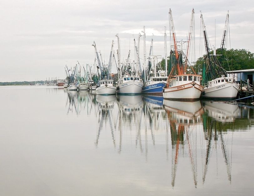
2019 Georgia Water Resources Conference                                                                                 1

Table of Contents                                           History of the Georgia Water Resources Conference
 Page    Contents                                           The Georgia Water Resources Conference has been held
                                                            biennially since May 1989. The inaugural conference in-
   2     Jim Kundell’s Legacy                               cluded 76 oral presentations and nine posters, with an in-
   3     Plenary and Luncheon Speakers                      creasing number of participants and attendees at every
   6     2019 Conference Committees, Volunteers,            succeeding conference. This year’s conference has over
         and Exhibitors                                     100 presentations and 36 posters.
                                                            Each conference has also seen new opportunities for
   7     Conference Sponsors
                                                            workshops and training sessions. The steering committee
   9     Schedule At-A-Glance                               includes representatives of the conference sponsors: U.S.
  10     List of Presentations                              Geological Survey, Georgia Department of Natural Re-
                                                            sources, Natural Resources Conservation Service, UGA,
  16     Conference Abstracts
                                                            and Georgia Institute of Technology - Georgia Water Re-
  60     Speaker Index                                      sources Institute. The co-sponsors include federal and
                                                            state agencies, professional associations, and citizen or-
Special Events                                              ganizations.
    Plenary Speakers (Tuesday)                              The idea for the first Georgia Water Resources Confer-
         Glen Daiger, University of Michigan                ence came from discussions of Dr. Robert Pierce, Alec Lit-
                                                            tle, and Kathy Hatcher, and stemmed from an initial
         Mark Masters, GA Water Planning & Policy Center
                                                            statewide water conference led by Dr. Ram Arora (GSU)
    Poster Session (Tuesday)
                                                            in 1984. The steering committee for that first conference
    Luncheon Speakers                                       was composed of Jeffrey Armbruster (USGS), Kathy
         Daniel Rochberg, Emory University (Tuesday)        Hatcher (UGA), Vernon Henry (GSU), Jim Kundell (UGA),
         Mary Walker, US EPA (Wednesday)                    Alec Little (UGA), Bob Pierce (USGS), Harold Reheis (GA
         Richard Dunn, GA EPD (Wednesday)                   EPD), and Bernd Kahn (Georgia Tech-GWRI).
    Evening Events                                          The GWRI (state water research institute program,
         Little Kings Happy Hour (Monday)                   through USGS) provided grants for the first and later con-
         Creature Comforts Happy Hour (Tuesday)             ferences to prepare the proceedings, which were edited
         Hidden Rivers, Premiere at Ciné (Tuesday)          by Kathy Hatcher. The complete set of conference pro-
                                                            ceedings (1989-2007) is available to the public online at
                                                            www.gwri.gatech.edu.
                                                            Since its inception, the goal of the Georgia Water Re-
                                                            sources Conference has been to provide an open forum
                                                            for the discussion of current water policies, research, pro-
                                                            jects, and water management in Georgia. Papers on top-
                                                            ics related to water policies, legislation, research, on-going
                                                            studies, technical innovations, issues and concerns, cur-
                                                            rent situation and trends, new approaches, management
                                                            programs, data and information, education, public partici-
The 2019 GWRC is coordinated by Duncan Elkins, with Katie   pation, institutional and financial arrangements, history,
  Hill and Wendy Paulsen of the UGA River Basin Center      culture, future needs and solutions, and other topics re-
                                                            lated to water management have been encouraged and
                                                            actively solicited.
                                                            This collaborative effort by water professionals has led to
                                                            the advancement of water science and management in
                                                            the state by providing a neutral and open forum for diverse
                                                            perspectives to be presented and discussed.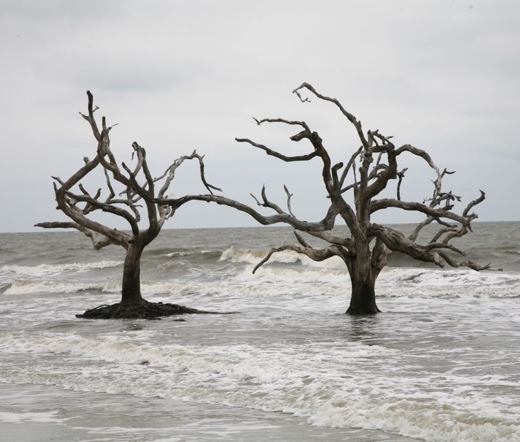
2019 Georgia Water Resources Conference                                                                               2

James (Jim) Kundell’s Legacy
For more than 30 years, Dr. James E. Kundell dedi-
cated his career to serving the state of Georgia through
research, service, and outreach. As the founding Direc-
tor of the Environmental Policy Program at the Carl
Vinson Institute of Government at the UGA, Dr. Kun-
dell’s scientific expertise branched far and wide -- from
water management and land conservation to academic
instruction at the Odum School of Ecology.
Jim served under three Governors, was appointed as a
board chairman with the U.S Army Corps of Engineers,
and authored or co-authored over 150 books on sub-
jects of environmental policy. Dr. Kundell’s gift for sci-
entific research was complemented by a talent for com-
municating science to decision-makers and the public.
He was also a gifted photographer, often capturing
Georgia’s natural beauty as he conducted site visits
and field work.
Today, his contributions to natural resource manage-
ment continue to influence students, policymakers, and
professionals across the country. Indeed, readers of water resource management research and policy will often find the
phrase “Courtesy of Jim Kundell” appearing repeatedly, an acknowledgement that illustrates the continued importance
of his work – it is a lovely and lasting reminder of the lives he’s touched and the environmental perspectives he’s
shaped. In short, Dr. Kundell went above and beyond the calling of most researchers, teachers, and public servants. In
many ways, honoring him is honoring the beautiful and resource-rich state of Georgia and the decades of work he put
into preparing us for its future. Dr. Kundell’s work, his commitment to this state, and his legacy is everlasting.
As artifacts that demonstrate both his passion and expertise, Dr. Kundell’s photographs remain with us as meticulously
detailed living records of Georgia’s natural beauty. The steering committee is honored to present a copy of his work to
Dr. Mark Masters and Dr. Glen Daigger as we honor his legacy at this year’s conference. Dr. Kundell was a fixture at the
Georgia Water Resources Conference since its inception in 1984 until his passing, ironically as the conference con-
vened, on April 19, 2017.

                      “Boneyard”                                        “Brunswick Port 6-28-05”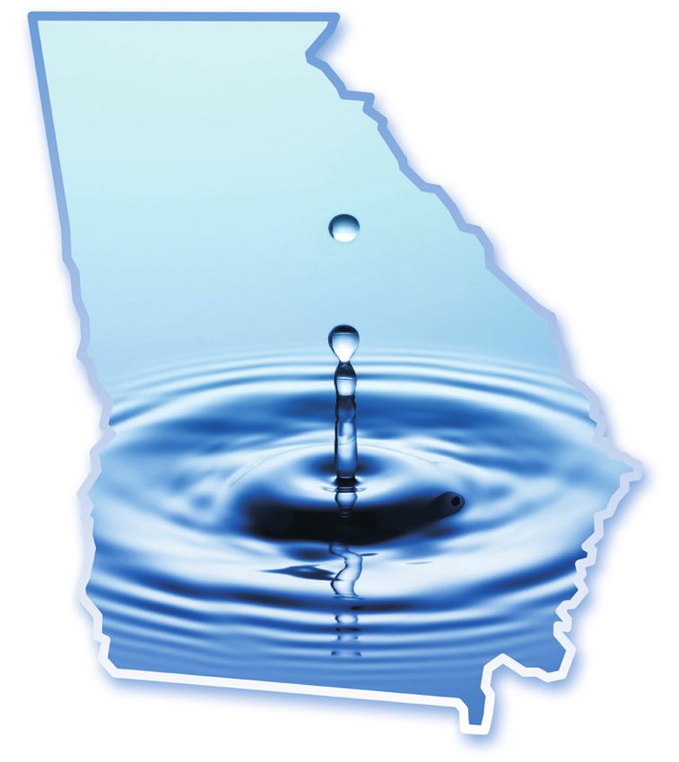
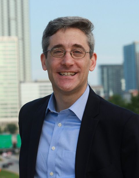
2019 Georgia Water Resources Conference                                                                           3

Glen T. Daigger, Ph.D., P.E., BCEE, NAE
Dr. Daigger is currently Professor of Engineering Practice at the
University of Michigan and President and Founder of One Water
Solutions, LLC, a water engineering and innovation firm.
He previously served as Senior Vice President and Chief Tech-
nology Officer for CH2M HILL where he was employed for 35
years, as well as Professor and Chair of Environmental Systems
Engineering at Clemson University.
Actively engaged in the water profession through major projects,
and as author or co-author of more than 100 technical papers,
four books, and several technical manuals, he contributes to sig-
nificantly advance practice within the water profession.
He has advised many of the major cites of the world, including
New York, Los Angles, San Francisco, Detroit, Singapore, Hong
Kong, Istanbul, and Beijing. Deeply involved in professional activi-
ties, he is currently a member of the Board of Directors of the Wa-
ter Research Reuse Foundation (TWRF), and a Past President of
the International Water Association (IWA).
The recipient of numerous awards, including the Kappe, Freese, and Feng lectures and the Harrison Prescott Eddy,
Morgan, and the Gascoigne Awards, and the Pohland Medal, he is a Distinguished Member of the American Society of
Civil Engineers (ASCE), a Distinguished Fellow of IWA, and a Fellow of the Water Environment Federation (WEF). A
member of a number of professional societies, Dr. Daigger is also a member of the US National Academy of Engineers.

Mark Masters, GA Water Planning & Policy Center
Mark Masters serves as Director of the Georgia Water Planning
and Policy Center at Albany State University and is a leading ex-
pert in agricultural water use and policy in the Southeastern US
Throughout his career, Mark has led numerous research and out-
reach projects related to water resources in Georgia and has posi-
tioned the Center as a trusted technical resource for the State and
its water planning efforts.
Beyond our borders, he’s recently supported development of the
Potomac River Basin Comprehensive Plan and, as a founding
member and Executive Manager of the ACF Stakeholders, Inc, was
instrumental in helping the group reach consensus on a Sustaina-
ble Water Management Plan for the entire ACF Basin.
Mark is active on a number of local, state and national advisory
boards including the American Farm Bureau Water Advisory Com-
mittee, Governor’s Soil and Water Advisory Committee, Institute for
Georgia Environmental Leadership Board of Directors and as a Su-
pervisor for his local Soil and Water Conservation District and
Board of the Georgia Association of Conservation Districts.
When he’s not busy professionally, Mark stays out of trouble volun-
teering at church and raising grass-fed beef with his family on their
farm in Terrell County. Mark and his wife Amy also enjoy watching
their three beautiful daughters make other kids look foolish on the
soccer field.
2019 Georgia Water Resources Conference                      4

Daniel Rochberg, Emory University
Daniel Rochberg is Chief Strategy Officer of Emory
University’s Climate@Emory initiative, an Instructor in
Emory’s Departments of Environmental Health and En-
vironmental Sciences, and a co-founder of the Georgia
Climate Project.
He spent seventeen years with the US Department of
State, where he served as Special Assistant to the lead
US climate negotiators under Presidents Bush and
Obama and was a member of US delegations to multi-
ple UN conferences, including the 2002 World Summit
on Sustainable Development in Johannesburg and the
2009 UN Climate Conference in Copenhagen, and
helped shape the President’s Global Climate Change
Initiative and the US-India Partnership to Advance
Clean Energy.
Daniel participated in the 2018 class of the Institute for
Georgia Environmental Leadership, was a term mem-
ber of the Council on Foreign Relations, and has re-
ceived the State Department’s Superior and Meritori-
ous Honor Awards and Emory University’s Sustainabil-
ity Innovator Award. He holds a B.A. in Human Biology
with honors in environmental science, technology, and
policy and an M.S. in Earth Systems, both from Stan-
ford University.
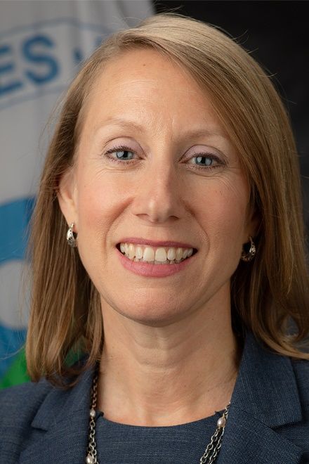
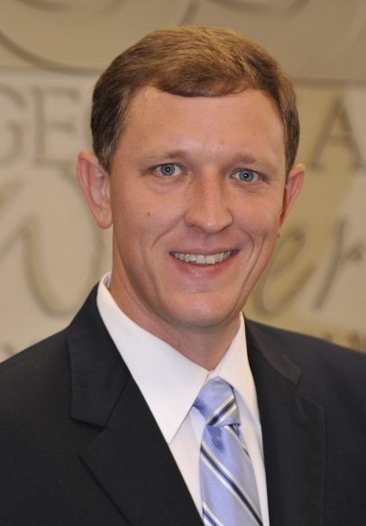
2019 Georgia Water Resources Conference                                     5

Mary S. Walker, Acting Regional Administrator, Region 4
Mary S. Walker is the Acting Administrator for EPA’s Southeast Re-
gion (Region 4). In this capacity, she leads EPA's efforts to protect hu-
man health and the environment in the eight southeastern states of Al-
abama, Florida, Georgia, Kentucky, North Carolina, Mississippi, South
Carolina and Tennessee, as well as six federally-recognized tribes.
Mary previously served as the Deputy Regional Administrator and Wa-
ter Division Director in the Region 4 office. In these roles, she worked
cooperatively with states to improve coordination and the timeliness of
EPA actions, actions she will continue as Acting Regional Administra-
tor.
Prior to her work at EPA, Mary served as the Assistant Director and
Chief Operating Officer for the Georgia EPD (EPD), where she over-
saw policy development and rulemaking for all media, permitting and
compliance programs, and for general agency operations.
Mary is a graduate of the Institute for Georgia Environmental Leaders,
served on the EPA/State E-Enterprise for the Environment Leadership
Council, and represented Georgia on the Southern States Energy
Board. She earned an undergraduate degree from Tulane University
and a master’s degree in Public Administration from the UGA. Mary is
an Alabama native and currently lives in the Atlanta area with her hus-
band and two children.
Richard E. Dunn, Director, Georgia EPD
Dunn was appointed Director of the EPD (EPD) of the Georgia Depart-
ment of Natural Resources effective June 16, 2016. Georgia EPD is
the state agency charged with protecting Georgia’s air, land and water
resources through the authority of various state and federal environ-
mental statutes. These laws regulate air quality, water quality, hazard-
ous waste, water supply, solid waste, surface mining, underground
storage tanks and others.
Dunn was the former deputy director of the Governor’s Office of Plan-
ning and Budget (OPB). He has also served as director of OPB’s
Health and Human Services division where he worked closely on the
implementation of the Affordable Care Act, the behavioral health set-
tlement agreement with the US Department of Justice, state health
care programs, and child welfare. Prior to joining OPB in 2011, he
worked for the Department of Behavioral Health and Developmental
Disabilities where he served as the deputy chief of staff. He has also
served as the acting director of the Governor’s Office for Children and
Families and chairman of the Georgia Occupational Regulation Re-
view Council. Prior to his career in public service, Dunn taught courses
on politics and public policy at Dickinson College and College of
Charleston.
Dunn earned a bachelor’s degree from Emory University and a mas-
ter’s degree from the UGA.
He and his wife, Susan, have one son. They reside in Atlanta.
2019 Georgia Water Resources Conference                                                               6

                                          April 16-17 2019
                           Conference website: www.georgiawaterconference.org/

2019 Conference Committees, Volunteers, and Exhibitors
Steering Committee                                   • Katie Brownson
• Bill Bailey, USACE                                 • Daniel Buhr
• Pam Burnett, GAWP                                  • Yannie Donaldson
• Daniel Calhoun, USGS                               • Stephanie Fulton
• Gail Cowie, Georgia EPD                            • Holly Hutcheson
• Dan DeoCampo, GSU                                  • Greg Jacobs
• Laurie Fowler, UGA River Basin Center              • Bear Jordan
• Aris Georgakakos, Georgia Tech                     • Cassidy Lord
• Steve Golladay, Jones Center                       • Jace Nelson
• Gary Hawkins, UGA Crop & Soil Sciences             • Laura Rack
• Yank Moore, Jekyll Island Authority                • Scott Raulerson
• Doug Oetter, GCSU                                  • David Richards
• Jenny Pahl, Corblu Ecology Group                   • Jenny Sanders
• Todd Rasmussen, UGA                                • Jon Skaggs
• Gil Rogers, SELC                                   • Ed Stowe
• Eric Somerville, USEPA                             • Caleb Sytsma
• Elizabeth Sudduth, Georgia Gwinnett College        • Maria Teresa Tancredi
                                                     • Elizabeth Tuttle
Technical Planning Committee                         • Carol Yang
• Duncan Elkins, UGA River Basin Center
• Laurie Fowler, UGA River Basin Center              Exhibitors
• Chuck Hopkinson, UGA Marine Science                • American Rivers
• Todd Rasmussen, UGA Warnell School                 • Georgia Environmental Protection Division
• Mark Risse, Georgia Marine Extension Service       • Greater Apalachee River Community
• Seth Wenger, UGA River Basin Center                • Jacobs
                                                     • Oconee River Greenway Commission
Conference Student Assistants                        • Upper Oconee Watershed Network
• Melissa Creviston                                  • USDA, Natural Resources Conservation Service
• Rachel Rotz                                        • USGS, South Atlantic Water Science Center
• Chris Bertrand                                     • YSI - A Xylem Brand
2019 Georgia Water Resources Conference                                                                             7

                                         April 16-17 2019
                         Conference website: www.georgiawaterconference.org/

2019 Conference Sponsors
The organizing and steering committees would like to thank the following sponsors (Champions, Advocates, and Sup-
porters) for their generous support of the 2019 Georgia Water Resources Conference:

                                             2019 Champions
2019 Georgia Water Resources Conference                8

                                      2019 Advocates

                                 2019 Supporters
2019 Georgia Water Resources Conference
                                                                 Schedule At-A-Glance
                        TRACK 1                      TRACK 2                     TRACK 3                        TRACK 4                           TRACK 5
      TUE
                      (Masters Hall)                 (Room Q)                    (Room R)                       (Room K)                          (Room L)
                                                                                                         4.1 GA Aquatic Connectivity
   8:30 - 10:00         1.1 Flint River         2.1 Computer Modelling     3.1 Research & Education                                        5.1 Speaker Practice Room
                                                                                                               Team (offsite)
   10:00 - 10:15                                                                        BREAK
    PLENARY           “Closing the Gap on One Water and Resource Recovery” by Glen Daigger, Professor, U of Michigan, President & Founder of One Water Solutions
   10:20 - 11:50          “Agricultural Water Use in Georgia: 2018 and Beyond” by Mark Masters, Georgia Water Policy & Planning Center, Albany State University
     LUNCH                         “The Georgia Climate Project: What Does a Changing Climate Mean for Water in Georgia and What Do We Do About It?“
   12:00 - 1:15                                            by Daniel Rochberg, Chief Climate Strategy Officer, Emory University
    1:30 - 3:00    1.3 Water Management I           2.3 Groundwater         3.3 Agricultural Wetlands   4.3 Preventing Lead in Schools      5.3 Lake Lanier & Septics
    3:00 - 3:15                                                                         BREAK
    3:20 - 4:50                                                                   POSTER SESSION
   WED
   8:30 - 10:00    1.5 Water Management II      2.5 Urban Infrastructure        3.5 Ecosystems            4.5 Surface Water Quality         5.5 Student Career Panel
   10:00 - 10:15                                                                        BREAK
                                                                                                                                           5.6 Hydrologically Connected
   10:20 - 11:50   1.6 Water Management III     2.6 Hurricanes/Flooding        3.6 Stream Health           4.6 Erosion & Nutrients
                                                                                                                                                  Groundwater
     LUNCH                                      Mary Walker, Acting Regional Administrator, Region 4, US Environmental Protection Agency
   12:00 - 1:15                                                          Richard Dunn, Director, Georgia EPD
    1:30 - 3:00    1.7 Water Management IV     2.7 Forecasting/Treatment         3.7 Restoration           4.7 Agricultural Modeling           5.7 Nutrient Trading
    3:00 - 3:15                                                                         BREAK
    3:20 - 4:50     1.8 Green Infrastructure     2.8 Climate & Drought            3.8 Wetlands           4.8 Vegetation & Hydrology           5.8 Conasauga River
                                                                                                                                                                          9
2019 Georgia Water Resources Conference 10
TRACK 1 1.6.2 “Including groundwater users into future irrigation buy-
1.1 Flint River out auctions in the FRB” by Jeffrey Mullen, UGA
1.1.1 “Restoring environmental flows in Flat Creek, Fayette 1.6.3 “Pilot study on alternative instream flow considera-
County, Georgia”, by Elliott Jones, Flint Riverkeeper tions” by Wei Zeng, Georgia EPD
1.1.2 “Evaluating effects of low streamflow on biotic compo- 1.6.4 “Protecting and restoring flows in our Southeastern
nents in the Upper Flint River” by Laura Rack, UGA Rivers: State policies and partnerships for water secu-
rity and sustainability” by April Ingle, River Network
1.1.3 “Where has all the water gone: Examining hydrologic
change in the Upper Flint River, GA?” by Stephen Gol- 1.6.5 “Demonstrating progress toward improving water sup-
laday, The Jones Center at Ichauway ply efficiency” by Johanna Smith, Georgia EPD
1.1.4 “Collaborative efforts toward drought resilience for 1.7 Water Management IV
people and nature in the Upper Flint River Basin” by 1.7.1 “Lake management strategies for source water quality
Ben Emanuel, American Rivers improvement” by Elizabeth Crafton, Hazen and Sawyer
1.3 Water Management I 1.7.2 “Conservation easements are effective in maintaining
1.3.1 “Locals vote to lead Indian River Lagoon restoration” ecosystem services in the Upper Chattahoochee Wa-
by Marcy Frick, Tetra Tech, Inc. tershed in the Southern United States” by Fabio Jose
Benez Secanho, UGA
1.3.2 “Georgia CoCoRaHS: The first decade” by Christine
McGehee, SERFC/NWS 1.7.3 “Managing forested wetlands in Georgia as a public
good” by John Paul Schmidt, UGA Odum School of
1.3.3 “Planning for future generations in the Upper Oconee
Ecology
watershed by engaging in scenario development for
desired outcomes in 2080” by Amy Rosemond, UGA 1.7.4 “Oconee Confluence Clean Water Alliance (OCCWA):
Odum School of Ecology Forested watershed protection to improve drinking wa-
ter source quality and quantity in the Upper Oconee
1.3.4 “Assessing water quality from highway runoff at se-
River Basin” by Cassidy Lord Upper Oconee Water-
lected sites in North Carolina with the Stochastic Em-
shed Network
pirical Loading and Dilution Model (SELDM)” by J. Cur-
tis Weaver, USGS 1.7.5 “Economic drivers make the case for reuse” by Mari-
lyn Hall, Athens-Clarke County Public Utilities Dept
1.3.5 “A web-based information management system for en-
vironmental data” by Martin Kistenmacher, Georgia 1.8 Green Infrastructure
Water Resources Institute, Georgia Tech 1.8.1 “Cumulative effects of Green Infrastructure (GI) on
1.5 Water Management II watershed hydrology: A case study and future direc-
tions” by Nahal Hoghooghi, UGA Institute for Resilient
1.5.1 “Comprehensive watershed management decision
Infrastructure Systems
support system development with hydro-geospatial
models integration - Lake Lanier Watershed, The case 1.8.2 “Green infrastructure, stormwater planter bulb-outs
study” by Sudhanshu Panda, University of North Geor- and modular rainwater storage as part of a triple-bot-
gia tom-line solution for an urban environment” by Alex Lo-
gan, Jacobs Engineering Group
1.5.2 “Can Georgia Power mitigate the ACF conflict?” by
Frederick Gordon, Columbus State University 1.8.3 “Atlanta's green infrastructure: Initiatives and impedi-
ments to just sustainability” by Lacey Davis, Georgia
1.5.3 “2019 update to the statewide nonpoint source man-
State University
agement plan” by Anna Truszczynski, Georgia EPD
1.8.4 “Stormwater management through potable use of har-
1.5.4 “Considerations for emergency action plans for high
vested runoff at the Georgia Tech Kendeda Building for
hazard dams in Georgia” by Kristin Ray, Hazen and
innovative sustainable design” by David Bell, Jacobs
Sawyer
Engineering Group
1.5.5 “Rainwater harvesting: A self-funded stormwater util-
1.8.5 “Rules of thumb for considering rainwater harvesting
ity” by Steve Williams, Steven Williams LLC
on jobs large or small” by Richard Hanson, Georgia
1.6 Water Management III Water Tanks
1.6.1 “Groundwater litigation: Recent cases, new strate-
gies”, Douglas Henderson, Troutman Sanders2019 Georgia Water Resources Conference 11
TRACK 2 2.6.3 “Effects of storm surge on coastal storm water sys-
2.1 Computer Modeling tems in Georgia” by Zhongduo Zhang, School of Civil
and Environmental Engineering, Georgia Institute of
2.1.1 “Evaluation of mixing capability for different nozzle
Technology
configurations inside a circular water storage tank us-
ing Computational Fluid Dynamics” by Tien Yee, 2.6.4 “Informing floodplain management and hazard com-
Kennesaw State University munication through probabilistic flood inundation maps”
by Brian Bledsoe, UGA Institute for Resilient Infrastruc-
2.1.2 “Revisiting the Longest Flow Path Algorithm” by Hui-
ture Systems
dae Cho, Institute for Environmental and Spatial Analy-
sis, University of North Georgia 2.6.5 “Obtaining event-based flood data through the USGS
Flood Event Viewer” by Tony Gotvald, USGS
2.1.3 “Growing application of hydraulic modeling and in-
creasing reliance on simulation results” by. Rasheed 2.7 Forecasting & Treatment
Ahmad, WSP USA 2.7.1 “Stakeholder's perceptions of a small-scale
2.1.4 “Climate change impact on crop yield and irrigation wastewater treatment facility in DeKalb County” by
demand in the Apalachicola-Chattahoochee-Flint Leesi Barinem, Dept of Geosciences, Georgia State
(ACF) River Basin” by Husayn El Sharif. Georgia Wa- University
ter Resources Institute, Georgia Tech 2.7.2 “Uncertainty in demand forecasting: Tampa Bay Water
2.3 Groundwater case study and relevance to regional planning in Geor-
gia” by John Clayton, Hazen and Sawyer
2.3.1 “A metric for assessing groundwater sustainability:
Case study, Well Field 3, Augusta-Richmond County 2.7.3 “The role of location cost considerations of firms on
area, Eastern Georgia” by Gerard Gonthier, USGS water pollution” by Temitope Arogundade, Clemson
University
2.3.2 “Fiber optic distributed temperature sensing: An
emerging groundwater monitoring technology” by Kris- 2.7.4 “Residential water efficiency in Georgia: Opportunities
ten Bukowski McSwain, USGS for further leadership, impact, and research” by Andrew
Morris, Metropolitan North Georgia Water Planning
2.3.3 “Simulation of groundwater flow in the Brunswick area,
District
Georgia, for 2015 Base Case and selected groundwa-
ter-management scenario” by Gregory Cherry, USGS 2.7.5 “Updating flood-frequency statistics and regional re-
gression equations for rural basins in the Southeastern
2.3.4 “Guidance for regulation of aquifer storage and recov-
United States” by Toby Feaster, USGS
ery” by Gail Cowie, Georgia EPD
2.8 Climate & Drought
2.5 Urban Infrastructure
2.8.1 “Simulated water availability in the Southeastern US
2.5.1 “Long-term responses of a Piedmont headwater
for historical and potential future climate and land
stream to the rapid urbanization of Its watershed” by
cover conditions” by Jacob LaFontaine, USGS
Ted Mikalsen, Georgia EPD (Retired)
2.8.2 “Drought vulnerability model development of Georgia
2.5.2 “Water supply forecasting as a tool for regional plan-
using updated geospatial data for management deci-
ning and utility management” by John Clayton, Hazen
sion support” by Sudhanshu Panda, University of North
and Sawyer
Georgia
2.5.3 “Effect of freshwater pollution on the integrity of bridge
2.8.3 “Resilience of the Middle Oconee River to anthropo-
structures in the State of Georgia” by Saman Hedjazi,
morphic watershed impacts and precipitation ex-
Georgia Southern University
tremes” by Emad Ahmed, UGA
2.5.4 “Analysis of quality-control split-replicate discrete wa-
2.8.4 “Climate-related variability in streamwater solute con-
ter-quality samples on an urban water-quality program
centrations and fluxes at Panola Mountain Research
in Gwinnett and DeKalb Counties, Georgia” by Andrew
Watershed, Georgia” by Brent Aulenbach, USGS
Knaak, USGS
2.8.5 “Low flow trends at Southeast US streamflow gages”
2.6 Hurricanes & Flooding
by Tim Stephens, UGA Institute for Resilient Infrastruc-
2.6.1 “Historic flooding in North and South Carolina follow- ture Systems
ing Hurricane Florence” by Toby Feaster, USGS
2.6.2 “Response of stressed marsh following Hurricane
Irma” by Jacque Kelly, Georgia Southern University2019 Georgia Water Resources Conference 12
TRACK 3 3.7.4 “Shore protection for a sure tomorrow” by Julia Shel-
3.1 Water Research & Education burne, UGA School of Law
3.1.1 “Private well water program to educate UGA Exten- 3.7.5 “The effects of beaver dams on bioavailable organic
sion Agents and homeowners” by Gary Hawkins, UGA carbon in urban streams” by Elizabeth Sudduth, Geor-
Crop and Soil Sciences gia Gwinnett College
3.1.2 “Water education and incentives for Murray 4-H'ers” 3.8 Wetlands
by Brenda Jackson, UGA Extension - Murray County 3.8.1 “Multiscale assessment of estuarine water and sedi-
3.1.3 “Educational materials and demonstration site de- ment quality in National Park Units within the South-
signed to better educate on the management of on-site east Coast Network” by Eric Starkey, National Park
wastewater” by Beth Lunsford, UGA Service - Southeast Coast Network
3.1.4 “Gwinnett Water Innovation Center” by Melissa 3.8.2 “Using satellite data to develop wetland hydrologic
Meeker, Gwinnett County DWR models” by Courtney Di Vittorio, Georgia Tech
3.3 Agricultural Wetland Policy & Practices 3.8.3 “Comparative metabolism of wetland-dominated estu-
aries” by Charles Hopkinson, UGA Marine Sciences
Moderated by Jenny Pahl, Corblu Ecology Group
3.8.4 “Determination of predominant water source(s) to a
3.5 Ecosystems
Georgia Piedmont wetland using hydrologic modeling”
3.5.1 “The creation of macroinvertebrate performance by Bruce Pruitt, US Army Corps of Engineers, Engi-
standards for a South Georgia stream restoration pro- neer Research and Development Center
ject” by Sean Miller, Mitigation Management
TRACK 4
3.5.2 “Of Limpkins and Apple Snails: Invasive species,
4.1 Georgia Aquatic Connectivity Team Working Group
novel ecosystems, and an uncertain future” by Chelsea
Smith, The Jones Center at Ichauway Moderated by Sara Gottlieb, The Nature Conservancy
(offsite)
3.5.3 “Wading through Georgia’s oyster regulations –
Shucking our way to a vibrant half-shell industry” by 4.3 Preventing Lead in School Drinking Water
Danielle Goshen, UGA Law/Georgia Sea Grant Moderated by Shannon Evanchec, with Samantha
3.6 Stream Health Becker, Herb Johnson, Paul Schwartz
3.6.1 “Stream health analysis using geospatial data to assist 4.5 Surface Water Quality
in further in-situ water quality analysis: Lake Lanier 4.5.1 “Source water optimization: How CCWA is combatting
Watershed, a case study” by Michael Mirroli, University taste and odor issues with aggressive in-lake and wa-
of North Georgia tershed improvements” by Roger Scharf and Kelly Tay-
3.6.2 “Mowers versus growers: Riparian buffer management lor, Jacobs Engineering
in the Southern Blue Ridge Mountains, USA” by Jenny 4.5.2 “Predicting harmful algal blooms in Middle Chattahoo-
Sanders, UGA Warnell School chee reservoirs” by Wesley Gerrin, UGA Warnell
3.6.3 “Knickpoints, undercuts, and slumps: Stream habitat School
monitoring at Chattahoochee National Recreation 4.5.3 “Microbial source tracking in the Chattahoochee River
Area” by Jacob M. McDonald, UGA National Recreation Area” by Anna McKee, USGS
3.6.4 “An assessment of water quality along the Appala- 4.5.4 “Tracking and managing non-point source pollution in
chian Trail in Georgia” by Caleb Sytsma, UGA Warnell the Lake Herrick Watershed, Athens, Georgia” by
School Ashwini Kannan, UGA College of Engineering
3.7 Restoration 4.5.5 “Strategic grazing for resistance to extreme weather
3.7.1 “Improving fish habitat below impoundments using al- events” by Subash Dahal, UGA Crop and Soil Sci-
ternative discharge structures” by Jay Shelton, UGA ences
Warnell School 4.6 Erosion & Nutrients
3.7.2 “White Dam removal: Lessons learned”, by Jay Shel- 4.6.1 “Geospatial model development to analyze the reser-
ton, UGA Warnell School voir volume change with the soil erosion model per-
3.7.3 “Uniting stormwater management and stream restora- spective” by Sidney McVay, University of North Geor-
tion strategies for greater water quality benefits” by Ro- gia
derick Lammers, UGA2019 Georgia Water Resources Conference 13
4.6.2 “Identifying the impacts of prescribed fire on nutrient TRACK 5
erosion into aquatic ecosystems utilizing lake sediment 5.3 Lake Lanier & Septic Systems
records from the SE USA” by Matthew Waters, Auburn
5.3.1 “An assessment of septic system nutrient contribu-
University
tions to Lake Lanier” by Brigette Haram, Gwinnett
4.6.3 “Strategic rotational grazing reduces sediment and County Dept of Water Resources
sediment carbon in runoff” by Anish Subedi, UGA Crop
5.3.2 “Assessment of septic system impacts on Lake La-
and Soil Sciences
nier” by Aris Georgakakos, Georgia Water Resources
4.6.4 “Removal of nutrients from agricultural wastewater us- Institute, Georgia Tech
ing modified biochar” by Jared Conner, UGA Geology
5.3.3 “Preliminary assessment of shoreline septic system
4.6.5 “The Mosaic Reservoir Process in sediment transport impact on Lake Lanier water quality” by Samuele Ceo-
in large river systems” by Benjamin Webster, Auburn lin, UGA Crop and Soil Sciences
University
5.3.4 “Advances in modeling the influence of onsite
4.7 Agricultural Modeling wastewater treatment systems on water quantity and
4.7.1 “Geospatial technology supported environmental im- quality” by Nahal Hoghooghi, UGA Institute for Resili-
pact assessment of historical gold mining in North ent Infrastructure Systems
Georgia” by Jeffery Robertson, University of North 5.3.5 “Septic system impact to surface water quality study”
Georgia by Daniel Johnson, Atlanta Regional Commission
4.7.2 “Projecting future agricultural water use under varying 5.5 AWRA Student Career Panel
climate scenarios” by Jeffrey Mullen, UGA Agricultural
Ridwan Bhuiyan (Jacobs), Amber Ignatius (University
and Environmental Sciences
of North Georgia), Cody Hale (Nutter & Associates),
4.7.3 “On-farm evaluation of dynamic variable rate irriga- and Jacob LaFontaine, USGS
tion” by Vasileios Liakos, UGA Crop and Soil Sciences
5.6 Clean Water Act Regulation of Hydrologically Con-
4.7.4 “ET-based smartphone applications for irrigation nected Groundwater: Supreme Court and EPA Ac-
scheduling in corn, cotton, and soybean” by George tions
Vellidis, UGA Crop and Soil Sciences
Moderated by Houston Shaner, Troutman Sanders
4.7.5 “Comparative study of estimation methods for deter-
5.7 Nutrient Trading
mining soil carbon and nitrogen content in right-of-way
areas in the State of Georgia” by David Penn II, Geor- Moderated by Laurie Fowler, UGA River Basin Center
gia Southern University 5.8 Conasauga River
4.8 Vegetation & Hydrology 5.8.1 “Range-wide declines and spatial synchrony in Amber
4.8.1 “Applying isotopes, mass balance, and xylem deuter- Darter (Percina antesella) populations identified with
ium correction to water use and sourcing of two bio- multivariate analysis” by Edward Stowe, UGA Odum
mass tree species” by Lauren Gill, UGA Warnell School of Ecology
School 5.8.2 “Establishing a fish and mussel monitoring program in
4.8.2 “Influence of forest and vegetation type on annual the Holly Creek Watershed” by Phillip Bumpers, UGA
evapotranspiration estimated by water budgets across River Basin Center, Odum School of Ecology
46 rural basins in the Southeastern US” by Seth 5.8.3 “Evidence of spatial and temporal changes in benthic
Younger, UGA Warnell School habitat conditions in the Conasauga River Mainstem”
4.8.3 “Simulated Longleaf Pine restoration increased by Mary Freeman, USGS
streamflow -- A case study in the Lower Flint River” by 5.8.4 “Genetics and the conservation status of the Trispot
(Jill) Ji Qi, Jones Center at Ichauway Darter, Etheostoma trisella, a recently federally listed
4.8.4 “Spatial and temporal dynamics of groundwater up- species endemic to the Coosa River drainage” by Ber-
take by riparian vegetation at the Panola Mountain Re- nie Kuhajda, TN Aquarium Conservation Institute
search Watershed” by Jeffrey Riley USGS, Georgia
State University2019 Georgia Water Resources Conference 14
POSTER PRESENTATIONS P.14 “Georgia Adopt-A-Stream: Citizen science and water
P.01 “A comparison of benthic invertebrates in the Etowah quality monitoring”, by Harold Harbert, Georgia EPD
River, 1958 & 2018” by Margi Flood, University of P.15 “Implementation guide to West Atlanta Watershed Alli-
North Georgia – Gainesville ance Community Science Program”, by Tori Mister,
P.02 “Gene flow among fish populations spanning the conti- Emory University, Rollins School of Public Health
nental divide in Gwinnett County” by Jacobo Rivera, P.16 “Twenty years of community stream monitoring in Ath-
Georgia Gwinnett College ens, GA: Analysis and policy recommendations” by
P.03 “Gene migration of sunfish (Lepomis spp.) populations Luke Marneault, Oconee County High School
across the Southeastern Continental Divide” by G. P.17 “Ecological restoration student design projects” by Jon
Amanda Haney, Georgia Gwinnett College, School of Calabria, UGA College of Environment and Design
Science and Technology P.18 “Native salt-tolerant landscaping for Georgia’s coastal
P.04 “Investigating coliform bacteria ratios relative to rainfall hazards” by Rachel Smith, UGA Marine Extension and
and stream stage in the Upper Chattahoochee River” Georgia Sea Grant
by Kristina J. Ashe, College of Coastal Georgia, Dept P.19 “A spatial model to identify and prioritize potential oys-
of Natural Sciences” ter reef restoration sites along the Georgia Coast” by
P.05 “Assessing coliform ratios in depressional wetlands as Cameron Atkinson, College of Coastal Georgia, Dept
potential indicators of hydrologic connectivity” by Cath- of Natural Sciences
erine Wang, Cedar Shoals High School P.20 “Coastal geomorphology change and spatial charac-
P.06 “Field methods and photogrammetric techniques for terization using airborne LiDAR along the Southeast
generating maps of invasive aquatic vegetation using Florida Coastline” by David Richards IV, UGA Geology
unmanned aerial system imagery” by Philip Ashford, Department
UGA Geography Department P.21 “Modeling small order watershed freshwater contribu-
P.07 “Predicting future potential resistance and resilience of tions to estuaries along the Georgia Coast” by Isabelle
river ecosystem function to altered hydrology” by Cait- McCurdy, College of Coastal Georgia, Dept of Natural
lin Conn, UGA River Basin Center Sciences
P.08 “Impacts of understory rhododendron removal on P.22 “Modeling potential hurricane storm surge flooding in
Southern Appalachian Mountain stream temperatures” the Lower Satilla River” by Sabrina Hodges, College of
by Scott Raulerson, UGA Warnell School Coastal Georgia, Dept of Natural Sciences
P.09 “Comparing rate of soil moisture loss for conventional P.23 “Using tidal stage to model hurricane storm surge in-
and conservation tillage systems” by undation risk to development along the Georgia Coast,
Rachel Collier, UGA College of Engineering, College of USA” by Clayton Davis, College of Coastal Georgia
Agricultural and Environmental Sciences P.24 “Water quality of a small, semi-isolated freshwater wet-
P.10 “Comparing LiDAR to standard field survey methods land on the Georgia Coast, USA” by Summer Wright,
for wetland mapping in three geographically isolated College of Coastal Georgia
wetland types” by Brian Clayton, The Jones Center at P.25 “Comparison of radon-derived groundwater discharge
Ichauway fluxes from Georgia tidal creeks” by Katherine Curran,
P.11 “Water quality monitoring in an urban nature preserve Georgia Southern University
undergoing stream restoration” by Michael Kshatri, P.26 “Groundwater conditions in Georgia, An interactive
Georgia State University website” by Debbie Gordon, USGS
P.12 “Prioritization of subwatersheds in the Upper Coosa P.27 “Investigating subsurface flow in a karstic system con-
River Basin for freshwater habitat protection” by Jon sidering the potentiometric surface” by Coleman Barrie,
Skaggs, UGA River Basin Center, Odum School of The Jones Center at Ichauway
Ecology P.28 “Impact of land cover on groundwater quality in the
P.13 “Assessment of the fate of anthropogenic nitrogen and Upper Floridan Aquifer in Florida, United States” by
phosphorus compounds in the Ogeechee River eight Ranjit Bawa, UGA Warnell School
years after the fish kill event“ by Sumaia Islam, Geor- P.29 “Investigating the relationship between water flow path
gia Southern University and contaminant risk from Georgia coal ash ponds in2019 Georgia Water Resources Conference 15
the Piedmont” by Claire Mathis, Georgia State Univer- cover” by James Deemy, College of Coastal Georgia,
sity Dept of Natural Sciences
P.30 “Flood-inundation maps for the Yellow River from P.35 “Multi-decadal forest streamflow behavior in Falling
River Drive to Centerville Highway, Gwinnett County, Creek, Georgia” by Todd Rasmussen, UGA Warnell
Georgia” by Jonathan Musser, USGS School
P.31 “A hybrid approach of analyzing urban flood risk: A P.36 “Comparative analysis of water-storage dynamics and
case study in the City of Atlanta, GA” by Nirajan Dha- storage-discharge relations among variably-urbanized
kal, Spelman College catchments within the South River Watershed, Dekalb
P.32 “Relationships between discharge and land use / land County, GA” by Jefferson Ibhagui, Georgia State Uni-
cover in the Altamaha watershed” by Kimberly Takagi, versity, Dept of Geosciences
Cedar Shoals High School P.37 “Assessing geophysical methods to detect nutrient
P.33 “Land use and land cover change in the Caloosa- movement from septic systems to Lake Lanier’ by Ma-
hatchee River Basin in Southern Florida” by Melissa ria Teresa Tancredi and Nandita Gaur, UGA Crop and
Creviston, UGA Geology Department Soil Sciences
P.34 “Discharge distributions in the Satilla River: Relation-
ships between discharge metrics and land use / land2019 Georgia Water Resources Conference 16
TRACK 1 Atlanta International Airport and runs south through suburban
and rural areas towards the Fall Line, with urban pressures
1.1 Flint River and water demand concentrated near the headwaters.
1.1.1 Restoring environmental flows in Flat Creek, Fayette Droughts occurred historically in the system, although low
County, Georgia flow events appear to be increasing in severity. We have lim-
L. Elliott Jones , Flint Riverkeeper ited information on the effects of low flows on the biotic com-
A hydrologic assessment of the Flat Creek Watershed in ponents specifically in the Upper Flint River. To help water
Fayette County, Georgia, was made to quantify releases managers quantify consequences of alternative management
from two water-supply reservoirs to restore environmental options affecting flows in the Upper Flint mainstem, we have
flows to Flat Creek. Streamflow-hydrograph analysis was identified biotic components of the system, including ma-
performed on streamflow data from a gaging station on croinvertebrates, small fishes, shoal bass, aquatic plants,
nearby Line Creek (Flat Creek is a tributary of Line Creek) and algae, that are of management interest and likely af-
that has more than 30 years of record. Eighteen surrogate fected by more frequent and prolonged low flows. We are
gaging stations throughout the Georgia Piedmont were se- compiling observations and studies from other river systems
lected for comparison to the Flat Creek watershed to identify to characterize potential impacts of low flow on these organ-
long-duration records that most closely mimic the character- isms, and to identify the types of data collection that could
istics of Flat Creek. Geographic, precipitation, land-use, and most effectively reduce uncertainty regarding low-flow ef-
hydrologic characteristics were compared for each water- fects. We intend this synthesis to identify components of the
shed. Hydrograph-separation analyses of streamflow data Upper Flint system that could act as ecosystem health indica-
from select surrogate streamgaging stations allowed compar- tors during low flow periods, as well as potential mechanisms
ison of long-term average streamflow and baseflow, and tem- of ecological resilience or recovery from prolonged drought.
poral trends in annual flows. Paired boxplots of monthly- 1.1.3 Where has all the water gone: Examining hydro-
mean streamflows and baseflows at selected gaging stations logic change in the Upper Flint River, GA?
for pre- and post-developments periods (1975 and before S.W. Golladay 1, B. Emanuel 2, G. Rogers 3
and after 1975), indicated reductions in seasonal streamflow 1
The Jones Center at Ichauway, 2 American Rivers, 3 South-
and baseflow due to urbanization. Environmental-flows anal-
ern Environmental Law Center
yses were used to compute two suites of hydrologic parame-
ters (1) Indicators of Hydrologic Alteration and (2) Environ- Recent droughts have elevated concerns about water secu-
mental Flow Components for select surrogate streamgaging rity, i.e., the ability to provide for public supply and support in
stations. The resulting parameters, which represent the entire stream requirements for healthy biota and associated eco-
range of streamflow conditions from low to high and quantify system services. These concerns are amplified in Georgia
both streamflow extremes and the duration of high and low and the southeastern US by projections of increasing popula-
streamflows, can be related by the influence of various flow tion, increasing temperatures, and uncertain precipitation.
conditions on a broad array of ecosystem characteristics per- Given uncertainty, there is a need for systematic assessment
taining to aquatic flora and fauna and the riverine environ- of hydrologic change and recognition of biological responses.
ment. The Fayette County Water System, aided by this hy- Human water use in the upper Flint is mostly municipal and
drologic analysis, intends to codify a new management re- commercial. Surface waters are the primary supply source in
gime for the long term to improve environmental flows in this the Upper Flint and returns are much less than withdrawals.
small watershed across a wide range of hydrologic condi- We used long term climate and stream flow data to assess
tions, not only during dry periods. hydrologic change in the upper Flint mainstem based on a
period of 1940 to 2016. Annual rainfall averaged 55-56
1.1.2 Evaluating effects of low streamflow on biotic compo-
inches per year and did not show a consistent trend during
nents in the Upper Flint River
the record. However, the frequency of severe droughts was
Laura Rack 1, Mary Freeman 2, Seth Wenger 1,3, Ben Eman- greater after the mid 1970’s. Interestingly, evidence suggests
uel 4; 1 UGA Odum School of Ecology, 2 USGS, Patuxent an increase in the intensity of rainfall, when it occurs. Like
Wildlife Research Center, 3 UGA River Basin Center, 4 Ameri- annual rainfall, annual average stream flow did not show con-
can Rivers sistent trends. However, metrics of minimum flows (1-day, 7-
The increasing frequency and persistence of droughts is be- day, 30-day) did show significant declines since the mid-
coming a greater concern with a changing climate. Prolonged 1970’s. Median monthly flows were also reduced throughout
and more frequent droughts result in low flow conditions that the year since the 1970’s. While understanding of specific bi-
can reduce the health and function of river systems. Drought ological responses is incomplete, enough is known to sug-
can also impact water availability for municipalities that rely gest that major faunal groups including freshwater fishes,
on rivers for water supply. The Upper Flint River Basin in mussels, and crayfishes are at risk. Biota and ecological pro-
Georgia provides an important water source for multiple mu- cesses depending upon growing season flows may be most
nicipalities and supports a diverse aquatic ecosystem that of- affected. Sufficient technical information exists to guide initial
fer multiple services, including recreation and biodiversity. management responses and a monitoring network is in place
The Upper Flint originates near the Hartsfield–Jackson to provide feedback. The challenge lies with engaging2019 Georgia Water Resources Conference 17
diverse social and economic interests in a process leading to Save Our Indian River Lagoon Project Plan – a multi-pronged
stream flows that provide supply while sustaining ecological approach to Reduce, Remove, Restore, and Respond: re-
structure and function. duce pollutant and nutrient inputs to the lagoon though cost-
1.1.4 Collaborative efforts toward drought resilience for peo- effective projects, remove the accumulation of muck, restore
ple and nature in the Upper Flint River Basin oysters and living shoreline ecosystem services, and meas-
ure progress to respond to changing conditions and new in-
Ben Emanuel, American Rivers
formation. To implement the plan, the City Councils and
This session will summarize the 2019 publication Ensuring County Commission approved a referendum for a ½ cent
Water Security for People and Nature: A Status Report from sales tax, which was included on the November 8, 2016 bal-
the Upper Flint River Working Group. The report describes lot. The sales tax passed by 62.4% of the votes and provides
Working Group efforts to enhance drought resilience in Geor- a dedicated funding source for IRL restoration projects
gia’s upper Flint River basin. The Working Group is a volun- throughout Brevard County over 10 years. To ensure the
tary collaborative made up of the staff leadership of all the sales tax funding is used responsibly, the plan is adaptively
large water utilities in the upper basin, local conservationists, managed through annual updates with input from an ap-
non-profit conservation organizations, and sustainability staff pointed Citizen Oversight Committee. During plan develop-
of Atlanta’s international airport. From its outset in 2013, the ment, it was estimated that the benefit of restoring the lagoon
Working Group has provided a forum for new conversations has a present value of $6 billion and a cost of $300 million. In
about the upper Flint River system’s future and its role in the 2019, the plan will be entering the third year of implementa-
communities that depend on it. Group members share a vi- tion and projects in all categories are underway, with 12 pro-
sion of a river system healthy enough to maintain the many jects completed and 38 additional under contract.
social, ecological, recreational and economic values that the
1.3.2 Georgia CoCoRaHS: The first decade
Flint River system provides—values such as water supply,
recreation, fisheries, property values and a healthy river eco- Christine McGehee, SERFC/NWS
system. Since the year 2000, four droughts have struck the The Community Collaborative Rain, Hail and Snow Net-work
Flint basin in the Georgia Piedmont. Each has brought on low (CoCoRaHS) was started in Colorado in 1998. Georgia
river flows that are unprecedented in the historical record of joined CoCoRaHS in 2008; since then, more than 1000 sta-
flows on the Flint. The report details the Working Group’s tions across the state have submitted observations. Numer-
consensus-based goals and strategies for river system resili- ous significant precipitation events have been documented,
ence. These goals fall under an over-arching common vision including Hurricane Matthew (2016) and Tropical Storm Fay
that the upper Flint River system has the capacity to meet (2008), and the September 2009 extreme rain event in the
human and ecological water needs, now and in the future. In metropolitan Atlanta area. CoCoRaHS observations more
addition, the report looks ahead to enhanced cross-sector than doubled the number of manual precipitation observa-
collaboration between water managers, conservationists, tions available for these events. CoCoRaHS data are availa-
river stakeholders and research scientists to improve under- ble via the CoCoRaHS website (www.cocorahs.org), as well
standing of environmental water needs and hydrologic trends as in the Global Historical Climatology Network archived data
in the basin. Researchers seek to inform efforts at goal-set- set maintained by the National Centers for Environmental In-
ting for river flows and drought resilience, and some are formation. The National Weather Service’s Southeast River
working to develop key indicators of ecological function, fo- Forecast Center uses CoCoRaHS data to perform quality
cused on main stem shoals, to improve understanding of the control on gridded multisensor precipitation estimates which
ecosystem impacts of hydrologic change in the basin. are key forcings to the river forecast model.
1.3 Water Management I 1.3.3 Planning for future generations in the Upper Oconee wa-
tershed by engaging in scenario development for de-
1.3.1 Locals vote to lead Indian River Lagoon restoration
sired outcomes in 2080
Marcy Frick 1 and Virginia Barker 2, 1 Tetra Tech, Inc., 2 Bre-
A.D. Rosemond, S.J. Wenger, P.M. Bumpers, UGA River Ba-
vard County Natural Resources Management Department
sin Center, Odum School of Ecology
The Indian River Lagoon (IRL) in Florida is an Estuary of Na-
People in the Upper Oconee watershed depend on the river
tional Significance, supporting one of the greatest diversity of
system for many ecosystem services, including drinking wa-
plants and animals in the nation. However, the IRL has been
ter, waste dilution, wildlife habitat, and recreation. Proactive
degraded because urban stormwater runoff has increased
management is critical to ensure these services will continue
pollutant loading, causing turbid conditions and algal blooms
to be provided in the future. Currently, many streams are im-
which negatively affect the aquatic community. These pollu-
paired due to fecal coliform contamination, and the biological
tants also contribute to muck accumulation, which releases
condition of many streams is declining. Increased population
nutrients, depletes oxygen, and creates a lagoon bottom that
growth and associated land use change, as well as climate
is not hospitable to marine life. The municipalities located in
change, will stretch the capacity for continued provisioning of
the IRL basin, led by Brevard County, decided to work to-
ecosystem services. Scenario-building is a compelling tool
gether to restore and protect the IRL system. Brevard
that brings many stakeholders together to engage in deci-
County, working with Tetra Tech, developed and adopted the
sion-making frameworks. The approach uses input from2019 Georgia Water Resources Conference 18
people with diverse perspectives, values, and views of de- warehouse and preprocessor for SELDM. Using techniques
sired outcomes, and incorporates different possible events, documented in a national BMP study (USGS, Granato, 2014)
conditions, and alternative decision-making structures. Spe- and available water-quality sample data from selected high-
cific outcomes are simulated using biophysical models and way-runoff and BMP site pairs, performance data from the
are synthesized and brought to life using visual art and story- NC highway-runoff research reports were analyzed and in-
telling. Alternative scenarios are useful to guide decision- corporated into the NC SELDM model for three BMP types.
making, as they lead to alternative outcomes, but can be 1.3.5 A web-based information management system for envi-
adaptively changed as values, desires, and watershed condi- ronmental data
tions change. Such a scenario-building exercise would com-
Martin Kistenmacher and Aris P. Georgakakos
plement the existing sustainability and stormwater manage-
ment plans of Athens Clarke-County (ACC), which are Georgia Water Resources Institute, Georgia Tech
geared towards planning for a sustainable and desirable fu- The Georgia Water Resources Institute (GWRI) has been de-
ture in ACC. Models for scenario development and applica- veloping and transferring to practice information manage-
tion exist in other rapidly growing areas in the US We will de- ment (IM) and decision support (DS) tools for water re-
scribe how these efforts could be successfully emulated by sources and environmental planning and management for
stakeholders in the Upper Oconee. These activities, with fo- over three decades. Such tools have been developed for the
cused and highly engaged planning specific to water re- ACF and other southeast river basins, the northern California
sources across the Upper Oconee watershed, including river system (including Trinity, Sacramento, Feather, Ameri-
Lakes Oconee and Sinclair, will foster more comprehensive can, and San Joaquin Rivers and the Bay delta), Nile River,
decision perspectives and better ultimate outcomes for cur- Yangtze River, and many other river basins. As the infor-
rent and future residents. The aim of scenario development mation technology platforms evolved, so did the GWRI
would be to provide high quality ecosystem services from the IM&DS tools, with the initial tools focusing on single-user PC-
Upper Oconee for two future generations of watershed resi- based applications and the subsequent versions evolving to
dents (ca. 2080). multi-user client-server applications and, more recently, to
1.3.4 Assessing water quality from highway runoff at selected web-based applications. In addition to IT platform changes,
sites in North Carolina with the Stochastic Empirical the GWRI IM and DS tools also evolved in applicability, with
Loading and Dilution Model (SELDM) the initial versions being highly customized and system spe-
1 2 cific and the later versions being more generally applicable.
J. Curtis Weaver , Gregory E. Granato , Sharon A. Fitzger-
1 1 2 The purpose of this article is to describe the structure, func-
ald , USGS South Atlantic Water Science Center, USGS
tionalities, and application range of the most recent GWRI in-
New England Water Science Center
formation management system (IMS), especially focusing on
In 2013, the USGS (USGS) and the US Federal Highway Ad- its distinguishing, state-of-technology features and applicabil-
ministration (FHWA) published the national Stochastic Empir- ity to a wide range of water resources and environmental
ical Loading Dilution Model (SELDM). SELDM uses infor- management applications. Value of IM tools in water and en-
mation about a highway site, the associated receiving-water vironmental resources management. IM tools are becoming
basin, precipitation events, stormflow, water quality, and the increasingly useful, if not necessary, as a means to keep up
performance of best management practices (BMP) to pro- and manage the rapid socio-economic, environmental, and
duce a stochastic population of runoff-quality variables climatic changes impacting water and environmental re-
(USGS, Granato, 2013). Output from SELDM allows the user sources. What makes these changes challenging is that their
to assess the statistical probability of water-quality standard impacts are interlinked, requiring integrated assessments
exceedances downstream of a stormwater discharge. In that combine multiple data types and sources across many
2015, the North Carolina Dept of Transportation (NCDOT) socio-economic and environmental sectors. A case in point is
partnered with the USGS to enhance the national SELDM provided by a recently initiated GWRI project (Septic System
with additional NC-specific data to improve the model’s pre- Impact Study, SSIS) aiming to assess the effect of septic
dictive performance across the State. SELDM streamflow systems on the water quality of Lake Lanier. This project is
statistics were computed for 266 selected continuous-record implemented in cooperation with the Gwinnett County Dept of
streamgages, which were added to the USGS StreamStats Water Resources, UGA, Cornell University, and USGS and is
application. Also, instantaneous streamflow at 30 selected described in separate articles of the conference. As part of
continuous-record streamgages across North Carolina with the SSIS project, GWRI is compiling and collecting a host of
drainage areas ranging from 4.12 to 63.3 square miles were geospatial and time series data for Lake Lanier and sur-
used to develop recession ratio statistics. Lastly, water-qual- rounding areas related to land use, hydrology, hydrodynam-
ity transport curves were developed for 27 streamgages for ics, meteorology, water quality, and ecology. Such data in-
suspended sediment concentration, total nitrogen, total phos- clude in-situ measurements with sensors and measurement
phorus, turbidity, copper, lead, and zinc. The NCDOT identi- devices, gridded climatic data, grab samples to be analyzed
fied NC highway-runoff water-quality and quantity data avail- in laboratories, sediment cores, visual media such as photo-
able from non-USGS sources. These data were reviewed for graphs and videos, GIS information in the form of shapefiles
upload into the FHWA Highway-Runoff Database, the data and rasters, and written documents such as permits andYou can also read