A GRAPH-MATCHING APPROACH TO INDOOR LOCALIZATION USING A MOBILE DEVICE AND A REFERENCE BIM - ISPRS Archives
←
→
Page content transcription
If your browser does not render page correctly, please read the page content below
The International Archives of the Photogrammetry, Remote Sensing and Spatial Information Sciences, Volume XLII-2/W13, 2019
                              ISPRS Geospatial Week 2019, 10–14 June 2019, Enschede, The Netherlands

 A GRAPH-MATCHING APPROACH TO INDOOR LOCALIZATION USING A MOBILE
                   DEVICE AND A REFERENCE BIM

                                                  F. J. Bot1 , P. Nourian2 , E. Verbree3
                                 1
                                   Sweco Netherlands, GIS&ICT, Geomatics, Fanny.Bot@sweco.nl
 2
      Delft University of Technology, Faculty of Architecture and the Built Environment, Design Informatics, P.Nourian@tudelft.nl
     3
       Delft University of Technology, Faculty of Architecture and the Built Environment, GIS Technology, E.Verbree@tudelft.nl

KEY WORDS: Indoor Localization, Spectral Graph Analysis, Graph-Matching, VI-SLAM

ABSTRACT:

The presented method provides for a possibility to perform graph-based indoor localization, by comparing the topological structure
embedded in a mesh model to the topological structure of a semantically rich reference model, specifically a BIM. However
different in nature and structure, both input sources can be converted to a graph of similar calibre, such that they can be tested for a
match. After a match between both graphs is found, the current position of the actor within the mesh model can be translated to the
room found in the graph. This room is now connected to a room within the reference graph, for which the semantics are stored in
the BIM. Returning these to the actor, a location description can be formed.

Many indoor positioning methods have been developed, which can provide an actor with a relative geometric place. Most preferred
are positioning systems not relying on a contingent system, which can be performed using a fusion of sensors embedded into a
mobile device. Such a system found to perform sufficiently is VI-SLAM, simultaneously building a geometric place and tracking
each pose and heading relatively. Its output is a mesh model, in which a viewshed of the indoor environment is built. Indoor
localization however, entails finding a humanly interpretable qualitative description of a place, rather than a quantitative position
in Euclidean space. In order to transcend such a position to a meaningful location, the context of an indoor environment has to be
understood. As the interpretation of indoor space is different across the board, misalignment in data sources representing the indoor
environment occurs.

                     1. INTRODUCTION                                  the integration of several different sensors (Fuentes-Pacheco
                                                                      et al., 2012, Zlatanova et al., 2013, Zafari et al., 2017). If
Indoor localization is a widely researched subject (Xiao et           an actor’s position can be integrated into a contextual map of
al., 2016, Yassin et al., 2016, Zafari et al., 2017, Zlatanova        indoor space, the location can be determined. Such a map
et al., 2013), as the complexity and size of many public              should be comprised of geometry, topology and semantics
buildings require extensive and properly designed methods to          (Isikdag et al., 2013). The geometry then represents the
facilitate location specific processes (Mautz, 2012, Lemmens,         physical boundaries of indoor space, while the topology
2013, Zlatanova et al., 2014). The methods created for such           describes the connectedness and nearness of the elements
services outdoor cannot be translated directly, new definitions       that form these boundaries. Semantics contain a functional
of each component need to be defined (Mautz, 2012). A proper          description of indoor space and its boundaries, which functions
localization process requires positioning into a semantically         as a context that can transcend a position into a location.
rich model of the physical environment, or the simultaneous
generation of both (Fuentes-Pacheco et al., 2012, Lemmens,            An autonomous SLAM process can output a polygonal mesh
2013). In other words, the context of an indoor environment           created on-the-fly as a model of indoor space, containing
has to be understood, such that a position can be transcended to      its geometry and topology. The output model is used as
a meaningful location.                                                a map in which an actor can be positioned. Semantics
                                                                      describing building geometry and topology are generally stored
The target user for such a process would be any actor executing       in a Building Information Model (BIM). The placement of a
any type of task inside a public building, thus an indoor             real-time position of the actor operating the hand-held device
localization system should be made easily attainable to anyone.       into the semantically rich map would generate an indoor
As the use of smartphones is widespread, the capabilities             location.
of such devices lend themselves for outdoor localization as
well, and many Location Based Systems (LBS) are specifically          The aim of the presented method is to develop a method to teach
aimed at smartphones, ideally such a system would be designed         a mobile device to understand its surroundings. This is to be
in order to function on a mobile device.                              reached by capturing the context and all of its relevant meaning,
                                                                      in order to transcend data to information. As the relevance of
Thus, a mobile indoor positioning system should be applied,           information is application dependent (Afyouni et al., 2012), it
along with the availability of a contextual 3D building model         should be grouped and retrievable by a single marker, i.e. to find
to position the actor in, so that the combined information            a location would be to find the an ID connected to information
defines the actors location. An autonomously operating process        about the room an actor is in. Therefore, an established standard
deemed sufficient for indoor positioning is Simultaneous              should be used to store contextual information, so that each
Localization and Mapping (SLAM), especially when based on             application can be type-focused and be built upon the same

                                                This contribution has been peer-reviewed.
                   https://doi.org/10.5194/isprs-archives-XLII-2-W13-761-2019 | © Authors 2019. CC BY 4.0 License.                  761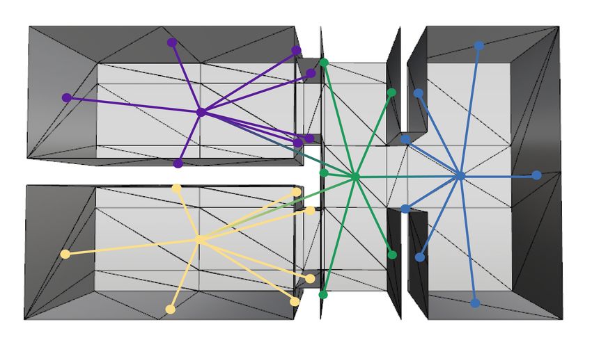
The International Archives of the Photogrammetry, Remote Sensing and Spatial Information Sciences, Volume XLII-2/W13, 2019
                               ISPRS Geospatial Week 2019, 10–14 June 2019, Enschede, The Netherlands

principles. Then, the accessibility of contextual information        by links which abstractly represent the connectivity between
while on location enables a wide range of possible applications.     elements (Nourian, 2018, Cromley, 1989, Worboys , Duckham,
The main objective on a data level would then be to generate         2004). The dual G ∗ of a graph can be constructed by translating
this single marker as a representation of the connection between     k-dimensional features to n − k-dimensional features in Rn
an indoor environment and an information source describing its       (Nourian, 2016, Weisstein, 2019a).
context. A method to perform this process is proposed, which
is built on best practices and underlying principles, taken from     2.2   Metric Space
an interdisciplinary viewpoint. See Figure 1 for an overview of
the explored research fields.                                        Metric Space is ”a set with a global distance function, that
                                                                     for every two of the set’s points gives the distance between
                                                                     them as non-negative real number” (Weisstein, 2019b), or
                                                                     the structure in which distances between all members can be
                                                                     defined (Worboys , Duckham, 2004). A metric, as ordered
                                                                     pair (S, d) can be imposed on a set S of arbitrary type, by
                                                                     defining how a shortest distance d between two members can
                                                                     be calculated. A structure is a complete metric when this
                                                                     shortest distance between two points is defined by a straight
                                                                     line, i.e. d(s, t) = |t − s|, s, t ∈ Rn . Metric space has
                                                                     a natural topology based on the notion of proximity, as for
                                                                     each point a set of nearest neighbours can be found based on
 Figure 1. Euler diagram of fields that apply to the theoretical     distance, and such a neighbourhood forms an open set (Munch,
         framework underlying the presented method.                  2017, Worboys , Duckham, 2004). The complete metric set of
                                                                     which all members are directly related in terms of distance and
                     2. TERMINOLOGY                                  angle, is called the Euclidean Space En (Worboys , Duckham,
                                                                     2004). It contains all n-tuples of real numbers (Stover ,
In order to integrate theory from varying research fields,           Weisstein, 2019) and provides for an intuitive abstraction of
an alignment in terminology is necessary. Thus a concise             physical space without a specific origin. It defines the structure
definition of indoor space is needed, in order to transcend          of the real vector space Rn of the same dimension.
a geometrically defined position to a human interpretable
location. Intuitively, we may perceive space as what cannot          2.3   Indoor Space
be seen or touched, as what is left when every other instance
around is defined. The term space has become an abstraction          Often, a space is defined in terms of either place, boundaries,
of everything outside of the boundaries of everything else. In       or function. A place may be a geographic space that has
mathematics and philosophy, space has become what defines            a potion on the face of the earth (Huisman , de By, 2009).
the boundaries of everything embedded within. A definition           Furthermore, a place ”is that, which is the same in different
more fitting to this description would be an ”expanse in which       moments to different existent things” (Leibniz et al., 2000).
everything is located” (Wolfram-Alpha, 2019), or even ”that,         In the OGC CityGML standard, indoor space is inside one or
which results from places taken together” (Leibniz et al., 2000).    multiple buildings, bounded by architectural components (Lee
Thus, a space represents a structure, often a set with relational    et al., 2016). The IFC BIM standard (ISO 16739) mentions
properties, to which all its members adhere. The characteristics     enclosure of an area, as well as the fact that a specific human
of a type of space provide the context in which objects can          activity can be executed in a space. This space is bounded either
be examined and represented (Huisman , de By, 2009, Marel,           by a functional transition, or a geometrical border. However,
2016), i.e. providing a type of grid on which embedded               mathematically speaking, a space dictates the type of properties
elements can be represented. Two specifically interesting            elements embedded within may have. A single type of space
classes of mathematical space are topological and metric space.      representation does not exclude the possibility of mapping an
                                                                     object into another. The physical world may then be represented
2.1     Topological Space                                            in several dimensions of ambient space, as to capture its
                                                                     complexity (Ekholm , Fridqvist, 2000, Zlatanova et al., 2014).
Topology describes the relationships between (parts of) objects,
that do not change under continuous deformation (Huisman             Pure positioning entails finding a point or area occupied by a
, de By, 2009). As these relations are intrinsic, and thus           physical object or person (Mautz, 2012, Groves, 2013, Sithole
invariant of ambient space, topology studies the construction of     , Zlatanova, 2016). This term is most used as to find a
an object, rather than its shape. It can be used to ”abstract the    position p = (X, Y, Z)T ∈ R3 , relative to the systems’
inherent connectivity of objects while ignoring their detailed       origin. Contrasting to the quantitative position, a location
form” (Weisstein, 2019c). A Topological Space is devoid of           entails finding a qualitative description of the occupied area.
geometric structure, so that the relations and characteristics of    Providing semantic context for a position would then allow an
objects can be examined qualitatively. The topology T on set X       actor to find a location with a specific meaning, or to perform
then defines topological space (X, T ). A Manifold can be seen       localization. It requires topological correctness of sensors used
as a topological space, which locally resembles Euclidean space      to determine the underlying position, and precise accuracy
(Edelsbrunner , Harer, 2010, Rowland, 2019). The topology            of is generally of less importance (Mautz, 2012). Based on
of a set can be simplified to a graph structure G , embedded         either position or location, an actor can execute navigation, as
in a Network Space that defines the topological connectedness        determining heading and velocity of the current trajectory, and
between its members using an unordered set of node pairs or          being guided along an optimal path to the destination (Mautz,
links. A Graph G = (N , L) is a set of nodes pairwise connected      2012, Groves, 2013, Sithole , Zlatanova, 2016). Figure 2
                                                                     exemplifies these principles.

                                                 This contribution has been peer-reviewed.
                    https://doi.org/10.5194/isprs-archives-XLII-2-W13-761-2019 | © Authors 2019. CC BY 4.0 License.                762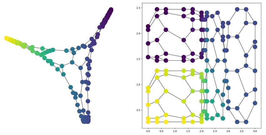
The International Archives of the Photogrammetry, Remote Sensing and Spatial Information Sciences, Volume XLII-2/W13, 2019
ISPRS Geospatial Week 2019, 10–14 June 2019, Enschede, The Netherlands
the relative position mi of each landmark in sight (Bailey ,
Durrant-Whyte, 2006). These landmarks, as sharp edges and
corners in the environment, are captured frame by frame, and
stitched together into a viewshed along the traversed trajectory.
Thus, rather than localization, SLAM executes simultaneous
positioning and mapping. The input BIM model is built
according to IFC standards, and assumed to contain standard
case geometry, and sufficient functional attribution. For the
Figure 2. Differences between positioning, localization and purposes of testing a matching method, both models contain
navigation for indoor situations. the same amount of rooms, though in real adaptation the BIM
would contain a full building (level) of which a part would be
A full representation of indoor space would allow an actor to matched with the graph extracted from the mesh.
execute activities as positioning, localization and navigation,
which would require geometric, topological and semantic 3.1 Graph Extraction from Mesh
information (Isikdag et al., 2013). The complex indoor space
can thus be modelled threefold: the geometric place can be The remapping of mesh M(F, V) into graph G(N , L) requires
modelled in Euclidean space, with positions (X, Y, Z)T ∈ R3 , first extracting the dual graph, after which it is simplified to a
as the formal representation of an object (Worboys , Duckham, graph representing rooms.
2004). The connectivity and boundaries can be modelled in
The dual graph is constructed based on face to face adjacency,
topological space as a primal 2-manifold surface S and its dual
as extracted from the .obj file structure the input mesh is stored
graph G ∗ . The function of each object can be modelled in
in (Figure 4). Then, each primal face normal is computed
semantic space, as a set of characteristics defining context and
assigned to its dual node. This attribute is used in a connected
facilitation of human activity. As such, indoor space can be
components algorithm, where two nodes are accepted into
occupied by elements, compliant to the rules of the structure.
the same region if the dot product similarity of both face
normals does not fall below a set threshold. The connected
3. METHODOLOGY components algorithm performs a depth first search through all
nodes stored in G , and returns regions representing similarly
Performing indoor localization on a mobile device is interpreted oriented partitions of the input mesh. Region size is used to
as a data matching problem, where a mesh of an indoor filter out clutter. Furthermore, only the largest horizontally
environment is compared to a reference model. This is done oriented surface is kept, as floor partition. This is tested using
by extracting a graph from both input sources, and comparing the dot product similarity to unit vector k̂ = (0, 0, 1)T . The
these to form a match (Figure 3). First, the input sources are result is a classification of G into a floor region and several wall
analysed. Then follows the extraction of topological graphs regions.
from both geometric models. As both input models are based
on different data types derived from different interpretations of
indoor space, both require a different method for extracting the
graph. In both cases, the resulting graph represents a network
of rooms, of which the intrinsic properties are analysed by
computing the spectral map. Thus the analysed geographic
indoor location, represented in a geometric model, is further
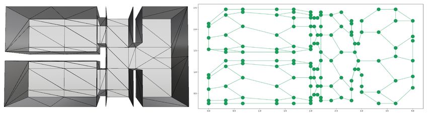
abstracted to a topological, then graph and then spectral model Figure 4. Mesh M of the test dataset and its dual graph G .
(Nourian et al., 2016).
In order to analyse the intrinsic properties of G , its spectral map
is computed. This is based on the graph Laplacian, constructed
as:
di if i = j
Li,j = −1 if (i, j) ∈ L (1)
0 otherwise
Figure 3. Methodological workflow for creating a match
between a VI-SLAM mesh and a reference BIM library of
solids. Graphs are extracted from both input types (yellow where Li,j = Laplacian operator over node pairs (i, j) ∈ G
arrows), which are compared and matched based on similarity di = degree of node i
(green arrow).
L = set of links (i, j) ∈ G
The input mesh is captured using Visual-Inertial SLAM
(VI-SLAM), an autonomously operating positioning Its spectrum of eigenvalues 0 = λ1 ≤ λ2 ≤ · · · ≤ λn allow for
system, reliable due to the integration of various sensors a simplification as Lx = λx, corresponding with eigenvectors
(Fuentes-Pacheco et al., 2012, Groves, 2013). The use x1 , . . . , xn . The number of eigenvalues which return λi =
of cameras integrated into a mobile device furthermore 0 corresponds with the number of connected components in
makes VI-SLAM attainable, affordable, portable, low on the graph. Furthermore, the second smallest eigenvalue (λ2 )
power consumption, and intuitively appealing (Riisgaard , provides for a particularly interesting interpretation of a graph.
Blas, 2003). Developed in the field of mobile robotics, the The graph is only connected if λ2 ≥ 0, and the further from
SLAM process tracks a position xk ∈ R3 relative to former zero, the stronger the graph is connected. Its corresponding
positions, the heading vk chosen from each position, and eigenvector x2 , the Fiedler vector, gives information about
This contribution has been peer-reviewed.
https://doi.org/10.5194/isprs-archives-XLII-2-W13-761-2019 | © Authors 2019. CC BY 4.0 License. 763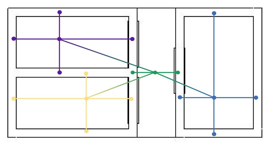
The International Archives of the Photogrammetry, Remote Sensing and Spatial Information Sciences, Volume XLII-2/W13, 2019
                            ISPRS Geospatial Week 2019, 10–14 June 2019, Enschede, The Netherlands

connectivity (Chung, 1996, Spielman, 2007, Luxburg, 2007).
The sign of its values may be interpreted as a division of the
data into parts according to its sparsest cut, or the cut for which
the least edges are broken. Such a cut can be stated as:

                                     X
                    cut(A, B) =             sij                (2)
                                  i∈A,j∈B

where       si,j = similarity between pair of nodes (i, j) ∈ G
            (A, B) = disjoint sets of nodes N resulting from the cut
                                                                         Figure 6. Spectral embedding (left) and dual embedding
                                                                          (right) of G , coloured according to Fiedler vector x2 .
A threshold t can always be found such that the set of edges
in a cluster S = {i : x2 ≤ t} is most optimally connected.
A common solution is to find the median cut as nlef t < 0 <
nright , meaning to find the largest gap between values of x2
within the graph (Spielman, 2007). The result for such a cut in
the test data set is visualized in Figure 5. A clustering algorithm
can be constructed which optimizes the cuts to be made, in
order to divide a graph into clusters (Luxburg, 2007).

                                                                         Figure 7. Result of spectral graph clustering of spectral
                                                                       coordinates of G as clusters in a spectral embedding (left) en
                                                                          the output remapped to their original positions (right).

                                                                      After clustering, nodes are filtered according to the extracted
                                                                      components and clusters. The clusters divide the single floor
                                                                      component into floor pieces, each now represented by a single
    Figure 5. Median cut in G based on its eigenspectrum.             node. These nodes are linked if the separated components are
                                                                      connected. For each floor component, the wall components
Alternatively to using Fiedler cuts to divide a graph, the spectral   in the same cluster are linked to it. The result as simplified
properties can be used as a basis for clustering. When mapping        graph G 0 is visible in Figure 8. Figure 9 shows conceptual
all nodes into a spectral embedding, the new coordinates              representation of the extracted graph.
imply clusters based not only on nearness of the faces all
nodes represent, but also the connectivity between them. A
spectral embedding of a graph can be given by assigning
eigenvectors as coordinate scalers to node i, e.g. placing it
at point (x2 (i), x3 (i)). The eigenvectors are used to draw
an almost always planar embedding, uniquely representing the
underlying structure of the graph (Nourian, 2016, Spielman,
2007, Luxburg, 2007). A spectral and dual embedding of G
can be found in Figure 6. Both visual representations prove
an implicit occurrence of three or four clusters within the test
data, of which the two rooms on the left are most strongly
disconnected from the rest of the model.
                                                                        Figure 8. G 0 in its spectral (left) and positional embedding
The coordinates x of the spectral embedding of G can be                                             (right).
used as input for a spectral clustering algorithm, where the
coordinates are treated as nodes, for which a nearest neighbour
graph is constructed (Pedregosa et al., 2011). Based on
normalized graph cuts, an input is created for a k-means
algorithm which assigns each data point with a cluster index.
Using the eigenspectrum of this nearest neighbour graph, the
number of k clusters is automatically determined. A large
advantage of this algorithm is that it is suitable for non-convex
clusters. Figure 7 shows the output of this algorithm, where
each determined cluster grouped by colour, and remapped into                    Figure 9. Conceptual representation of G 0.
the dual embedding of G .

                                                This contribution has been peer-reviewed.
                   https://doi.org/10.5194/isprs-archives-XLII-2-W13-761-2019 | © Authors 2019. CC BY 4.0 License.                 764
The International Archives of the Photogrammetry, Remote Sensing and Spatial Information Sciences, Volume XLII-2/W13, 2019
ISPRS Geospatial Week 2019, 10–14 June 2019, Enschede, The Netherlands
3.2 Graph Extraction from BIM 3.3 Spectral Graph Matching
The remapping of the reference BIM into graph H(N , L) Aside from embedding and clustering, spectral properties are
requires first extracting room representations, after which a further used to find a match between G 0 and H. Graph
graph can be formed. matching entails finding correspondence between two given
graphs, where the underlying structures are at least highly
A room in a BIM model is inherently stored as an ifcSpace. similar (Conte et al., 2004). Theoretically, G 0 and H should
A BIM space is defined as ”an area or volume bounded actually be isomorphic, as the represent the same indoor environment.
or theoretically. Spaces [..] provide for certain functions within However, due to differences in interpretation of indoor space,
a building.” (BuildingSMART, 2016). The composition of an the resulting models are slightly different (compare Figures 8
ifcSpace is defined by its storey and placement, and defines and 10). The option remaining would then be to construct an
elements within it. As such, it can be used to determine inexact matching process. To further explore the application
the distinction as well as the connection between rooms. A of spectral graph properties, its embedding is used as input
navigable graph model can be extracted by handling each for a method which can match co-spectral graphs, even if the
ifcSpace as node (Diakité , Zlatanova, 2016). A wall, as a number of nodes in both graphs is different. Here, clusters of
basic building element which can bound a partition of indoor nodes are compared within an embedding of all nodes into a
space, is stored as ifcWall. In its standard case it is stored as vector subspace (Kosinov , Caelli, 2002). This re-embedding
a (poly)curve c built by Points pi = (x, y)T ∈ R2 describing is based on the eigenspectrum of the data covariance matrix Σ
the general footprint of the element, and an extrusion depth d. as Σ = UΛUT . By using the matrix of eigenvectors U, the
Thus, an ifcWall is stored as a solid S(c, d). The coordinates projection of data point x can be constructed using:
are defined relative to object an origin O = (X, Y, Z)T ∈ R3
and set on a reference plane. The coordinates of the origin
are relative to the full model. Each ifcSpace entity may be x̂ = UTk x (3)
connected with its bounding walls by relative placement. Thus,
for each ifcSpace a set of ifcWall objects may be extracted. where x̂ = coordinates in vector sub space
If the same wall is related to more than one ifcSpace, it should
UTk = transposed matrix of first k eigenvectors
be duplicated. Furthermore, the amount of ifcDoor elements
x = coordinates of spectral embedding
embedded into the walls around an ifcSpace represent the
number of links that should be laid from a single ifcSpace
to one or more other ifcSpace elements. Walls bounding the To be come a useful operator, U it has to be decreased to the
same room are related by the Path Connectivity element, use of the first k eigenvectors. Of these first k eigenvectors,
which is used to ensure a single material or profile definition. only the first few dimensions are meaningful, corresponding to
Thus it can be used to group walls per room. It can be applied the dimensionality of x. In the described case, each data point x
to check if rooms assigned to spaces in the previous step are represents a 2D coordinate of a node in the spectral embedding
correct and complete. If after these steps any of the walls is of the graph (Figure 6 left). The new embedding x̂ can be used
unassigned, the coordinates embedded in the ifcWall elements as a basis for another clustering algorithm (Figure 12). If the
may be used to find their placement. Graph H (Figure 10) is nodes in the same cluster are similar enough to pass as a match,
now constructed by translating each ifcSpace to a node, and it is accepted. This can be tested based on certain attributes
connecting it with a new node for each adjoining ifcWall. A of the nodes, e.g. the coordinates in the original graph or the
conceptual representation of H can be found in Figure 11. spectral values.
Figure 10. H in its spectral (left) and positional embedding
(right).
Figure 12. Clusters found in the vector subspace embedding
for G (green) and H (blue).
Figure 11. Conceptual representation of H.
This contribution has been peer-reviewed.
https://doi.org/10.5194/isprs-archives-XLII-2-W13-761-2019 | © Authors 2019. CC BY 4.0 License. 765The International Archives of the Photogrammetry, Remote Sensing and Spatial Information Sciences, Volume XLII-2/W13, 2019
ISPRS Geospatial Week 2019, 10–14 June 2019, Enschede, The Netherlands
4. LOCALIZATION PROCESS 5. CONCLUSIONS
After a match between mesh graph G and reference graph H is The proposed method provides for a possibility to perform
found, its characteristics can be used as a basis for localization. graph-based indoor localization, using a mesh model created
In the mesh model, the actor capturing the indoor environment using SLAM on a mobile device and a reference BIM. The
has a current position. As it is situated in the local coordinate inherent organization of such a model has a great influence
system the mesh is stored in, this position can be connected to on how a representation of indoor space can be built, and
the closest room found in G . The nodes of this room in G are on how it relates to the physical world. Understanding these
connected to the same room in H through the matching process. implications by mathematically defining the type of models at
These are attributed with a marker, e.g. an id, which refers to hand, can aid in understanding how encountered problems can
a set of semantics describing the characteristics of this room. be solved. Thus, an indoor space is redefined here as a structure
Returning these to the actor, a location description is formed. defining the representation of its embedded objects, such that
mathematical processes can be applied to form a humanly
4.1 Discussion understandable description of environments embedded into
indoor space. Its aspects are defined as follows:
A factor strongly influencing the possibility of using purely
structural graphs as a basis for indoor localization, is the
interpretation of indoor space lying at the basis of the model. • Geometry - The place an actor is in
G was formed based on a VI-SLAM process, in which a
• Topology - The structure of the place the actor is in
sufficient description of an environment is a geometrically
and topologically structured viewshed of an already traversed • Semantics - The meaning of the place the actor is in.
trajectory. A set of connected points describes a surface
bounding navigable space. As such, G 0 (Figure 9) shows nodes
for each surface partition encountered while traversing through Indoor localization then entails positioning an actor into
the environment. H was formed based on a BIM, in which a a meaningful context. As such, the spectral analysis of
sufficient description of an environment entails the geometric the topology of indoor space allows for correct semantic
definition of bounding solids, preferably enriched with context assignment to indoor positions, so that an understanding of
defining semantics. Without additional interpretation, H indoor space can be reached.
would contain a minimal amount of nodes. However, nodes
representing walls are repeated when connected to several
ACKNOWLEDGEMENTS
ifcSpace elements, to mimic the results of G (Figure 11). A
difference still occurs around doors: each surface partition next
to a door is turned into a node, where there would be a single Thanks to Abdoulaye Diakité for his guidance during the
ifcWall in the BIM. However different in nature and structure, initiation and exploration phase of this research.
both input sources can be converted to a graph of similar
calibre, such that they can be tested for a match. However, REFERENCES
before such a match can be made, a number of rooms must
have been visited, in order to retrieve a meaning full graph.
Afyouni, I., Ray, C., Claramunt, C., 2012. Spatial models for
Thus, initializing the proposed process would entail extensive
context-aware indoor navigation systems: A survey. Journal of
traversal through an unknown building, which would not be
Spatial Information Science, 4, 85–123.
an ideal situation for indoor localization. Alternatively, the
process could be initialized by providing an actor with a marker Bailey, T., Durrant-Whyte, H., 2006. Simultaneous localization
representing the hallway or room to start from, as well as its and mapping (SLAM): Part I. IEEE Robotics and Automation
structure relative to the two closest partitions of indoor space to Magazine, 13, 108–117.
be defined. Nonetheless, the topological structure underlying a
mesh model captured using a mobile device is strongly similar BuildingSMART, 2016. IFC4 Add2 - ifcSpace.
to the topological structure that can be extracted from a BIM http://www.buildingsmart-tech.org/ifc/IFC4/Add2/html/.
model representing the same indoor environment. However,
neither a boundary mesh nor a volumetric BIM can fully Chung, F., 1996. Spectral Graph Theory. CBMS Regional
capture the knowledge of indoor space and its topological Conference Series in Mathematics, 92, American
relations (Khoshelham , Dı́az-Vilariño, 2014). A culmination Mathematical Society, Providence, Rhode Island.
of different dimensionalities is necessary in order to fully
represent the meaning of an indoor space (Sithole , Zlatanova, Conte, D., Foggia, P., Sansone, C., Vento, M., 2004. Thirty
2016, Zlatanova et al., 2014). One of the goals for the proposed Years of Graph Matching in Pattern Recognition. International
method was to let go of the purely geometrical approach often Journal of Pattern Recognition and Artificial Intelligence, 18,
applied in indoor localization methods, and utilizing another 265–298.
type of descriptor of the indoor space. This structural approach
Cromley, R. G., 1989. Digital Cartography. Prentice-Hall.
proves the amount of intrinsic characteristics of indoor space to
be found in a good representation, while exemplifying its sole Diakité, A. A., Zlatanova, S., 2016. Extraction of the 3D
adaptation would not prove sufficient. Free Space From Building Models for Indoor Navigation.
ISPRS Annals of Photogrammetry, Remote Sensing and Spatial
Information Sciences, IV-2/W1, 241–248.
Edelsbrunner, H, Harer, J, 2010. Computational Topology: An
Introduction. American Mathematical Society.
This contribution has been peer-reviewed.
https://doi.org/10.5194/isprs-archives-XLII-2-W13-761-2019 | © Authors 2019. CC BY 4.0 License. 766The International Archives of the Photogrammetry, Remote Sensing and Spatial Information Sciences, Volume XLII-2/W13, 2019
ISPRS Geospatial Week 2019, 10–14 June 2019, Enschede, The Netherlands
Ekholm, A., Fridqvist, S., 2000. A concept of space for building Pedregosa, F., Varoquaux, G., Gramfort, A., Michel, V.,
classification, product modelling, and design. Automation in Thirion, B., Grisel, O., Blondel, M., Prettenhofer, P., Weiss,
construction, 9, 315–328. R., Dubourg, V., Vanderplas, J., Passos, A., Cournapeau, D.,
Brucher, M., Perrot, M., Duchesnay, E., 2011. Scikit-learn:
Fuentes-Pacheco, J., Ruiz-Ascencio, J., Rendón-Mancha, J. M., Machine Learning in Python. Journal of Machine Learning
2012. Visual simultaneous localization and mapping: a survey. Research, 12, 2825–2830.
Artificial Intelligence Review, 43, 55–81.
Riisgaard, S., Blas, M. R., 2003. SLAM for Dummies. A
Groves, P. D., 2013. Principles of GNSS, inertial, and Tutorial Approach to Simultaneous Localization and Mapping,
multisensor integrated navigation systems. 2nd edn, Artech 22.
House.
Rowland, T., 2019. Manifold.
Huisman, O., de By, R. A., 2009. Principles of GIS. ITC http://mathworld.wolfram.com/Manifold.html.
Enschede. Sithole, George, Zlatanova, Sisi, 2016. Position, Location,
Place and Area: an Indoor Perspective. ISPRS Annals of
Isikdag, U., Zlatanova, S., Underwood, J., 2013. A
Photogrammetry, Remote Sensing and Spatial Information
BIM-Oriented Model for supporting indoor navigation
Sciences, III-4, 89–96.
requirements. Computers, Environment and Urban Systems,
41, 112–123. Spielman, D. A., 2007. Spectral Graph Theory and its
Applications. 48th Annual IEEE Symposium on Foundations of
Khoshelham, K., Dı́az-Vilariño, L., 2014. 3D modelling of Computer Science (FOCS’07), 29–38.
interior spaces: Learning the language of indoor architecture.
International Archives of the Photogrammetry, Remote Sensing Stover, C., Weisstein, E. W., 2019. Euclidean Space.
and Spatial Information Sciences - ISPRS Archives, 40, http://mathworld.wolfram.com/EuclideanSpace.html.
321–326.
Weisstein, E. W., 2019a. Dual Graph.
Kosinov, S., Caelli, T., 2002. Inexact Multisubgraph Matching http://mathworld.wolfram.com/DualGraph.html.
using Graph Eigenspace and Clustering Models. T. Caelli,
Weisstein, E. W., 2019b. Metric Space.
A. Amin, R. P. W. Duin, D. de Ridder, M. Kamel (eds),
http://mathworld.wolfram.com/MetricSpace.html.
Structural, Syntactic, and Statistical Pattern Recognition,
Springer Berlin Heidelberg, Berlin, Heidelberg, 133–142. Weisstein, E. W., 2019c. Topology.
http://mathworld.wolfram.com/Topology.html.
Lee, J., Li, K., Zlatanova, S., Kolbe, T. H.,
Nagel, C., Becker, T., 2016. IndoorGML. Wolfram-Alpha, 2019. Space.
http://docs.opengeospatial.org/is/14-005r4/14-005r4.html. https://www.wolframalpha.com/input/?i=space.
Leibniz, G. W., Clarke, S., Ariew, R., 2000. Leibniz and Clarke: Worboys, M. F., Duckham, M., 2004. GIS: A Computing
Correspondence. Perspective. CRC press.
Lemmens, M. J. P. M., 2013. Indoor Positioning. GIM Xiao, J., Zhou, Z., Yi, Y., Ni, L. M., 2016. A Survey on
International, 5. Wireless Indoor Localization from the Device Perspective.
ACM Computing Surveys, 49, 1–31.
Luxburg, U. Von, 2007. A Tutorial on Spectral Clustering A
Yassin, A, Nasser, Y, Awad, M, Al-Dubai, A, Liu, R, Yuen,
Tutorial on Spectral Clustering. Statistics and Computing, 17,
C, Raulefs, R, 2016. Recent Advances in Indoor Localization:
395–416.
A Survey on Theoretical Approaches and Applications. IEEE
Communications Surveys Tutorials, PP, 1.
Marel, H. Van Der, 2016. Reference Systems for Surveying and
Mapping, Lecture Notes. Delft University of Technology. Zafari, F., Gkelias, A., Leung, K., 2017. A Survey of Indoor
Localization Systems and Technologies. 1–30.
Mautz, R., 2012. Indoor Positioning Technologies. ETH Zurich,
Department of Civil, Environmental an Geomatic Engineering. Zlatanova, S., Liu, L., Sithole, G., Zhao, J., Mortari, F., 2014.
Space subdivision for indoor applications. GISt Report No. 66,
Munch, E., 2017. A User’s Guide to Topological Data Analysis. Delft University of Technology, OTB Research Institute for the
Journal of Learning Analytics, 4, 47–61. Built Environment.
Nourian, P., 2016. Configraphics: Graph theoretical methods Zlatanova, S., Sithole, G., Nakagawa, M., Zhu, Q., 2013.
for design and analysis of spatial configurations. Delft Problems in indoor mapping and modelling. International
University of Technology, Delft. Archives of the Photogrammetry, Remote Sensing and Spatial
Information Sciences - ISPRS Archives, 40, 63–68.
Nourian, P., 2018. On Topology and Topological Data Models
in Geometric Modeling of Space, Lecture Notes.
Nourian, P., Rezvani, S., Sariyildiz, I. S., Van Der Hoeven,
F. D., 2016. Spectral modelling for spatial network analysis.
Proceedings of the Symposium on Simulation for Architecture
and Urban Design (simAUD 2016).
This contribution has been peer-reviewed.
https://doi.org/10.5194/isprs-archives-XLII-2-W13-761-2019 | © Authors 2019. CC BY 4.0 License. 767You can also read