Evidence of a Miocene volcano-sedimentary lithostratigraphic sequence at Ngwa (Dschang Region, West Cameroon): Preliminary analyses and geodynamic ...
←
→
Page content transcription
If your browser does not render page correctly, please read the page content below
Journal of Petroleum Technology and Alternative Fuels Vol. 2(3), pp. 25-34, March 2011
Available online at http://www.academicjournals.org/JPTAF
©2011 Academic Journal

Full Length Research Paper

       Evidence of a Miocene volcano-sedimentary
 lithostratigraphic sequence at Ngwa (Dschang Region,
       West Cameroon): Preliminary analyses and
                geodynamic interpretation
            P. L. Kenfack1*, P. Tematio1, M. Kwekam1, G. Ngueutchoua2 and P. R. Njike1
               1
                Faculty of Sciences, University of Dschang, Campus C., P.O. Box.67, Dschang, Cameroon.
                   2
                    Faculty of Sciences, University of Yaounde I, P.O. Box 812, Yaounde, Cameroon.
                                                    Accepted 28, January, 2011

    The Ngwa sedimentary sequence is situated on the southern flank of the Bambouto volcano. Analysis
    of petrography, lithostratigraphy, mineralogy, morphology and morphometry enabled the
    reconstruction and interpretation of their stratigraphic architecture, depositional and paleogeographic
    setting, the origin of the sediments and the geological history of this region. The lithostratigraphic
    sequence of the Ngwa sedimentary deposits reveals two major phases of sedimentation: (i)
    Conglomerates with pelitic sandstone matrix, pelitic sandstone and carbonaceous clayey shale with
    lignite intercalations; and (ii) conglomerates and arkosic sandstones. Pebbles from the Ngwa
    conglomerates are sub-rounded to spherical. The grain size distribution of the sandstones indicates a
    high amount of very fine clay particles. The sediments of Ngwa are well sorted. The homometrical
    character of sandstones is related to their fluvial origin. The presence of sillimanite and kyanite testifies
    to the metamorphic provenance of a part of the Ngwa sediments while the basaltic pebbles indicate the
    volcanic origin of the other part. During the Miocene, Ngwa area experienced detrital sedimentation with
    alternation of volcanic phases related to volcanic activity at Mount Bambouto.

    Key words: Ngwa, Cameroon, lithofacies, detrital sedimentation, Miocene.

INTRODUCTION

In Cameroon, many studies concerning sedimentary                   Logone Birni (Petters, 1979 in Ntep et al., 2000; Allix et
rocks have been carried out, but most of those studies             al., 1983 in Ntep, 2000). No earlier study noted the
have been dedicated to the coastal sedimentary basins:             presence of sedimentary units higher up in the West
Kribi/Campo (Belmonte, 1960; Njiké and Eno, 1987;                  Cameroon Highlands. Recently geological surveys of the
Ngueutchoua, 1996; Angoua, 2006), Douala (Reyre,                   Dschang region (belonging to the piedmont zone of the
1964; Salard-Cheboldaef, 1976, 1977; Njike, 1986; Njike            southern flank of Bambouto massif) identified fragmental
and Eno, 1987; Njike, 2005; Ngoss III et al., 2006) and            sedimentary lithofacies at Ngwa and enclaves of
Rio Del Rey (Njoh, 2007). Those studies also concerns              sedimentary rocks randomly distributed in volcanic
the major intracontinental basins: Mamfe (Njieatih, 1997;          complex (Kenfack, 2002; Kwekam, 2005). However, very
Petters et al., 1987; Eyong, 2003), Mbere Djerem (Njike            little is known about the features of these sedimentary
et al., 2000; Tchouatcha et al., 2010), Babouri Figuil             rocks including: their age, provenance and a possible
(Dejax et al., 1989; Ndjeng, 1998), Mayo Oulo Lere                 relationship with the coastal sedimentary basins deposits
(Brunet et al., 1988; Ndjeng and Brunet, 1998; Hell,               of Cameroon. Lithostratigraphic and petrographic
2006), Hamakoussou (MINEF, 1995; Tsafack, 1998) and                investigations of the Ngwa sedimentary rocks presented
                                                                   in this paper were done in order to better understand the
                                                                   provenance of the detrital sediments and their
                                                                   stratigraphic      architecture,    depositional      and
*Corresponding author. E-mail: lambertkenfack2003@yahoo.fr.        palaeogeographic setting and the geological history of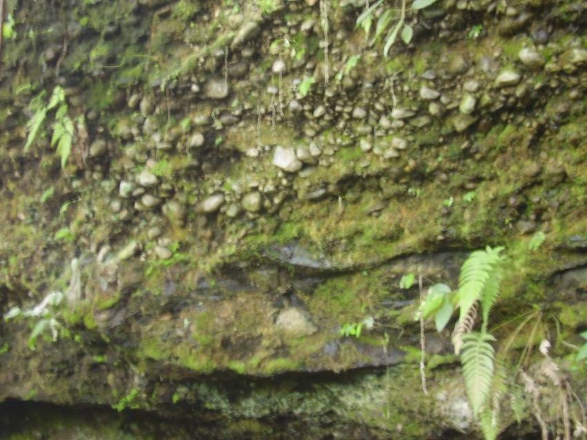
26       J. Petroleum Technol. Altern. Fuels

Figure 1. An overview of the geological map of Dschang and the study area (The inset shows the discussed area and location of
the four lithofacies).

the region.                                                           southern slope of Mount Bambouto belonging to the
                                                                      Cameroon volcanic line (CVL) (Figure 1). The CVL
                                                                      represents a 1600 km long chain of Cenozoic volcanic
REGIONAL SETTING                                                      and sub-volcanic complexes that straddles the continent-
                                                                      ocean boundary and extends from the Gulf of Guinea to
The study was carried out in the area of Ngwa, a small                the interior of the African continent (Marzoli et al., 2000).
locality in the eastern part of the Dschang region on the             It constitutes a major tectonic feature in Central Africa
Kenfack et al 27
characterized by a zone of fault-bounded horsts and RESULTS AND INTERPRETATION
grabens that extended in the direction of N30°E. These
structures are thought to be induced by a network of Field observations
combined faults, related to an intra-plate sliding system of
high extension (Deruelle et al., 1991). Its continental part Lithological characteristics and reconstruction of the
is represented by the major volcanic massifs of Mounts lithostratigraphic sequence Ngwa
Cameroon, Rumpi, Manengouba, Bambouto and Oku
and the volcanic necks and plugs of the Kapsiki plateau Four main lithofacies, labelled L1, L2, L3 and L4, were
and Benue Valley (Nono et al., 2004). Mount Bambouto identified at the Ngwa site see black stars in (Figure 1).
is the third largest volcano of the CVL after Mounts Lithofacies L1 crops out in the central part of the Ngwa
Cameroon and Manengouba (Kagou et al., 2001). The sedimentary basin which is represented by the following
Dschang region, on the southern slope of Mount lithological succession (Figure 2a). Sedimentary breccia
Bambouto in the West Cameroon Highlands, forms the overlying ignimbrite deposit and constituted of poorly
northern edge of the Mbo plain (Figure 1). It is sorted quartzite pebbles in sandstone matrix. The
characterized by various volcanic products covering the sandstone is constituted of angular millimetric grains of
basement granitoids (Kwekam, 2005). The Mbo plain is quartz which are held firmly by grayish clay matrix. The
considered to be an eastern extension of the Mamfé quartzite pebbles are angular and do not show clear
basin (Figure 1). The basement rocks in the Dschang traces of abrasions, evidence of which suggest a
region consist of Neoproterozoic granite-gneisses, Late proximal position relative to the source and gravity
Proterozoic granitoids intruded within the granite- induced transportation under the influence of gravity. The
gneisses, and gabbroic dykes that crop out in the two thickness of the bed is about 80 cm.
previous units. The gabbroic dykes are generally related Above the breccias lies the sandstone. This sandstone
to Atlantic rifting. The basement rocks are partly covered bed is similar in all aspects to the sandstone matrix of the
by a very thick layer of volcanic deposits derived from underlaying breccia. The thickness of this bed is about 20
Mount Bambouto. Volcanic activity at Mount Bambouto cm. The outcrop L1 is limited by more or less weathered
began around 500,000 years ago, originating as a volcanic tuff rich in diverse elements such as small wood
complex sequence of basalt, trachyte and phonolite lava fragments.
flows and ignimbrites (Tchoua, 1974; Youmen, 1994; Lithofacies L2 was also described in the central part of
Marzoli et al., 2000; Nono et al., 2004; Nkouathio, 2007). the Ngwa area. It shows a succession of sedimentary
In this sequence, trachy-rhyolitic ignimbrites, with a breccia and pelitic sandstones (Figure 2b). The breccias
vitroclastic structure containing quartz, alkaline feldspars, are composed of pebbles floating in a sandstone matrix.
hornblende, opaque minerals and various enclaves The pebbles are small in size (less than 4 cm in
characterize the initial explosive volcanic phase diameter), mainly quartzitic, smooth and well rounded
(Ngountié Dedzo, 2003; Nono et al., 2004). Sandstone without any preferential orientation. Weak graded
and conglomerate are interlayered within the volcanic bedding of the pebbles was observed near the top of this
rocks. The most important sedimentary rocks outcrop is layer and the grains are held together by a clayey matrix.
at the Ngwa locality in the eastern part of the Dschang The thickness of the bed ranges between 20 and 40 cm.
region (Figure 1). These breccias are overlain by a layer of clayey
sandstone which is petrographically very similar to the
matrix of the basal breccias. It is constituted of very fine
MATERIALS AND METHODS (mostly less than 0.5 mm width) grained quartz held
together by grayish clay. The layer is about 75 cm thick
In order to reconstruct the past sedimentary environment, outcrops and is covered by tuffs.
were sought in Ngwa and the surrounding areas. After outcrops
where found, each of them was localized with a GPS and then, the
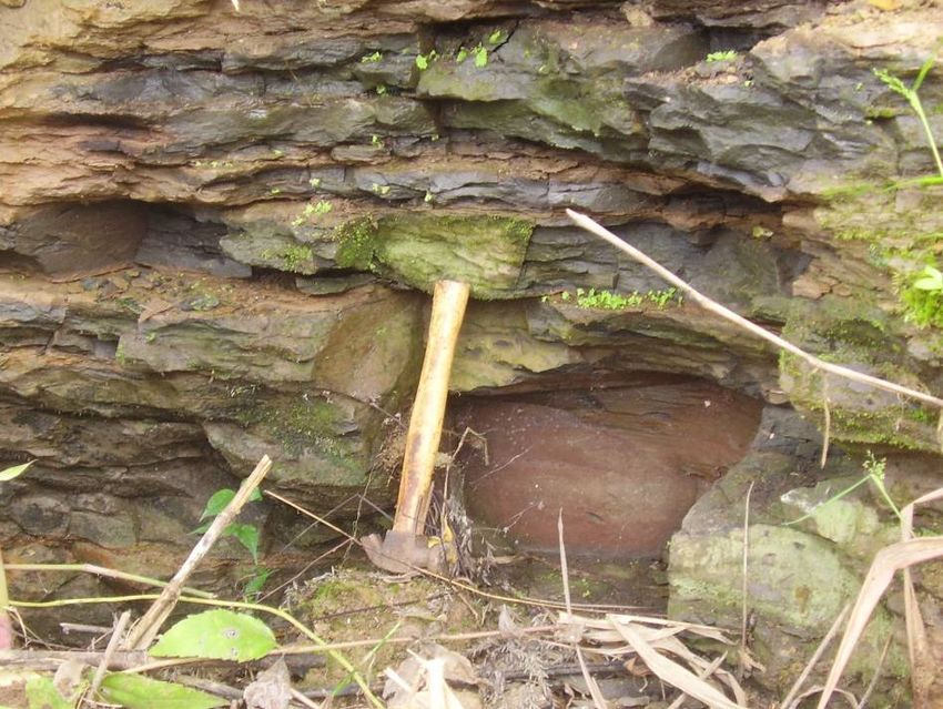
Lithofacies L3 is located in the NE part of the Ngwa
succession of lithofacies was described from the base to the top of locality (Figure 1). It corresponds to a thick layer of
the sequence of each outcrop. The description was essentially conglomerates about (5 m thick) with intercalation of
based on the lithological characreristic of sediments, their sandstones (Figure 2c). The conglomerates are made up
granulometry and the sedimentary structures. This description of pebbles and cobbles with a sandstone matrix (Figure
enabled to establish correlation between outcrops and then draw
3). Those clasts varied from 40 to 100 mm in diameter.
the synthetic lithostratigraphical sequence of the Ngwa sedimentary
deposits. In the laboratory, many sedimentological analysis They are essentially volcanic in origin (basaltic), with a
including morphology, morphometry, granulometry and heavy considerable amount of quartzitic pebbles. The clasts are
minerals analysis were carried. Morphology analysis was carried on smooth, well rounded, without a preferential orientation.
pebbles according to the works of Cailleux (1942). Morphometry The sandstone matrix contains very abundant fine sand
was also carried on pebbles according to the works of Zingg (1935) grains of quartz embedded in a clay matrix. The
and Cailleux (1942). Granulometry was conducted using a sieves
column of the Saulas scale set up on a vibrator. Heavy minerals
intercalated sandstones have the same petrographic
were extracted using bromoform from the fine fraction below 250 characteristics as the muddy sandstone matrix, but
µm deriving from sieving. The combination of field and laboratory contain no clasts. Their beds are lenticular, over 2 m long
works gave results presented thus. and 10 to 30 cm thick.28 J. Petroleum Technol. Altern. Fuels
Outcrop Sample Stratigraphy Lithology
Soils
Tuffs (Miocene)
E2S 1 Sandstone
Outcrop L1
E1S 1 Breccia (Miocene)
Ignimbrite
Basement
1m
(a)
Outcrop Sample Stratigraphy Lithology
Soils (Quaternary)
Tufs(Miocene)
E2S2 Pelitic sandstone (Miocene)
Outcrop L2
E1S2 Conglomerate (Miocene)
Ignimbrite
1m
Basement
(Précambrien)
(b)
Outcrop Samples stratigraphy lithology
Soil (Quaternary)
Tuf (Miocene)
E2S3
L3 Arkosic sadstone
(Miocene)
E1S3 Conglomerates
(Miocene)
2m
Trachyte
(Miocene)
0
(c)
Figure 2. Differents lithofacies of Ngwa formation. . (a) The L1 lithofacies of Ngwa, (b) The L2
lithofacies of Ngwa, (c) The L3 lithofacies of Ngwa.Kenfack et al 29
Figure 3. conglomerates with pelitic sandstone cement in the L3 lithofacies.
Figure 4. carbonaceous clayey shale with slaty cleavage and plants remains in the L4
lithofacies.
The conglomerates of facies L3 are overlain by a 4 m. This sandstone is covered by tuffs, which are, in
micaceous arkosic sandstone layer, whose grains float in turn, overlain by basalts.
a whitish clay matrix. Grains, whose size varies from 1 to Lithofacies L4 is situated in the SE part of the Ngwa
3 mm, are similar to those of the cement of the underlying area (Figure 1). It is made up of a 6 m thick layer of
conglomerate. They are angular and their surfaces are carbonaceous shale, (Figure 4). It is petrographically very
well polished. The thickness of this layer is greater than similar to the carbonaceous clayey shale observed in L2.30 J. Petroleum Technol. Altern. Fuels
Figure 5. A synthetic lithostratigraphical sequence of the Ngwa sedimentary
deposits.
Nevertheless, it is more compact, with slaty cleavage conditions prevailed in the depositional environment
defining sub-horizontal sheets of varied thickness (Figure characterizing the standing body water such as lake or
4). It contains a high proportion of partially decomposed swamp (Bandin, 1989; Pederson and Calvert, 1990; Dill
plants remains and randomly distributed lenses of lignite. et al., 2007; Namik et al., 2007).
The above descriptions, the altitude relations of the
outcrops and the respective contacts between the facies
enable them to be correlated and presented as a Results of laboratory analysis
composite lithologic sequence in the Ngwa area in Figure
5. Morphometry, morphology and grain size distribution
This succession highlights the fact that the sedimentary of the Ngwa sediments
units in the Ngwa area represent positive, lithologic
sequences characterized by coarse (pebbles and The morphometric and morphological analysis of the
cobbles) at the bottom of the sequence, which becomes Ngwa sediments refer to the pebbles from the
progressively finer and more clayrich upwards (Figure 5). conglomerates, wherever the grain size distribution
Therefore, in the Ngwa locality, there have probably been concerns the sandstones. The main results of the
two major phases of sedimentation. The first phase led to morphometry and morphology studies were analyzed
the deposition of sedimentary breccias and statistically and presented in Tables 1 and 2. From the
conglomerates with a pelitic sandstone matrix, the morphological point of view, 92% of the pebbles and
overlying clayey sandstone and the carbonaceous clayey cobbles from the Ngwa conglomerates have the
shale with lignite intercalations (outcrops L1, L2 and L4). sphericity ranging from 0.47 to 0.96 (Table 1). The most
The presence of tuffs between sandstones and clays is abundant group (20% of particles) has a sphericity
due to an interruption of sedimentation by volcanism. The between 0.75 and 0.82. The less abundant groups (less
second phase of sedimentation led to the deposition of than 5% of pebbles each) have a sphericity between 0.33
conglomerates and arkosic sandstones of outcrop L3. and 0.47, or between 0.96 and 1.03. The mean sphericity
The stratigraphic column of the synthetic lithologic (nici) is equal to 0.72. Consequently, the pebbles from the
sequence (Figure 5) in this environment shows “fining up” Ngwa conglomerates are essentially sub-spherical to
sedimentary lithosequence, and consequently highlights spherical. 95% of these pebbles have the flattening index
the decreasing of the depositional energy upwards (Miall, ranging between 1.14 and 3.51, with a mean value (nici)
1997). The presence of carbonaceous clayey shale at 2.22 (Table 2). The morphometric analysis based on
suggests that during their formation, reducing or anoxic the Chamley abacus (1988) (not shown) indicates thatKenfack et al 31
Table 1. Statistical analysis of the pebbles sphericityni,: number of the pebbles of L1 and L2 display rough to slightly
variable in class i ci the mean value of class i. rounded surfaces suggesting a short distance of
transportation. They derived probably of the erosion of
Classes ni ci nici the neighboring basement. Meanwhile the basaltic and
0.33-0.40 2 0.36 0.73 quartzitic pebbles and cobbles of L3 are dense and well
0.40-0.47 4 0.43 1.74 polished, suggesting long distance of transportation in a
0.47-0.54 10 0.50 5.05 high energy medium of fluvial type (Lindsey et al., 2007;
0.54-0.61 7 0.57 4.02 Cojan and Renard, 1997).The basaltic cobbles were
0.61-0.68 16 0.64 10.32 eroded from the basalts of Mount Bambouto and
0.68-0.75 13 0.71 9.29 transported on long distances while the quartzitic pebbles
0.75-0.82 20 0.78 15.70 are products of the Precambrian basement complex
0.82-0.89 17 0.85 14.53 which have been recycled many times.
0.89-0.96 9 0.92 8.32
The grain size distributions of the Ngwa sandstones are
presented in Table 3. The clayey fraction (particles below
0.96-1.03 2 0.99 1.99
50 µm across) represents 30.63% of the sandstone in L1,
Total 100 71.71
63.16% in L2 lithofacies and 20.02% in L3. In L1, the
most abundant sand fraction, 69 and 37% of the
sandstone, corresponds to the particles between 450 µm
and 2 mm in diameter. In L2, it corresponds to particles
Table 2. Statistical analysis of the pebbles flatness ni: the number
of variable in class i; ci the mean value of class i. between 180 and 280 µm representing 72.99% of the
sandstones; while in L3 it corresponds to the particles
Classes ni ci nici between 450 µm and 2 mm in diameter. These results
indicate the presence of a very high amount of very fine
1.14-1.93 42 1.53 64.47
clay particles in L2 sandstones which classifies them as
1.93-2.72 41 2.32 95.32
wackes. Meanwhile a large amount of sand grains of
2.72-3.51 12 3.11 37.38 variable dimensions (from fine to coarse sand) constitute
3.51-4.30 3 3.90 11.71 the sandstones in L1 and L3 lithofacies.
4.30-5.09 1 4.69 4.69 The cumulative curves of the grain size distributions
5.09-5.88 0 5.48 0.00 show (Figure 6) very steep slope between 0.1 and 0.3
5.88-6.67 0 6,27 0.00 mm in L2 (see the X axis). In L1 and L3, they are more
6.67-7.46 0 7.06 0.00 extended and slightly smooth, ranging between 0.1 and 1
7.46-8.25 0 7.85 0.00 mm.The cumulative curve of sample E2S2 have a
8.25-9.04 1 8.64 8.64 sigmoid shape, highlighting that the particles from these
Total 100 222.23 sandstones were well sorted (S0=1,14) during the
depositional process. Accordingly, during a relatively long
transportation, these sediments may have been well
sorted by a regular flow, probably of fluvial type (Tricart,
1959). Meanwhile for samples E2S1 and E2S3, the
cumulative curves are asymmetrical highlighting that
those sand are leached deposits, poorly sorted (S0=1, 69
and S0=1, 67) characterized by variations in the speed of
energetic flow.
The above results show that all the sandstones are
immature (each sample has over 5% of terrigenous clay
matrix), poorly sorted (the sorting index for each sample
is over 0.5). This indicates the weakness of the current in
the depositional environment or rapidity in the
depositional process. Sediments have not been subject
to input or any mechanical energy after deposition
(Robert, 1980). These grains parameters and the
presence of carbonaceous clayey shale described above
allow concluding that the depositional environment is a
confined zone, likely lacustrine, or swampy.
Microscopic examination of heavy minerals from the
Ngwa sandstones indicates the presence of about 15%
Figure 6. Cumulative curves of the grains size distribution in L1, L2 sillimanite, 22% muscovite, 17% biotite, 12% kyanite and
and L3 lithofacies. 34% of opaque minerals. The presence of sillimanite and32 J. Petroleum Technol. Altern. Fuels
Table 3. Grains size distribution of the Ngwa sandstones mm: grain seizes in millimetres (sieve diameter), W.S: Raw weight of samples
retained in each sieve; %S: Weight percent of sample,%C: Cumulative weight percent of sample.
E2S1 E2S2 E2S3
Sieves diameter(mm)
W.S S (%) C (%) W.S S (%) C (%) W.S S (%) C (%)
2.00 1.6 1.2 1.2 0.0 0.0 0 8.1 5.6 5.6
1.00 55.3 39.9 41.0 0.8 1.1 1.1 50.3 34.5 40.0
0.80 20.1 14.5 55.5 0.6 0.0 1.1 22.0 15.1 55.1
0.45 28.1 20.4 75.8 2.9 3.9 5.1 37.1 25.4 80.5
0.315 11.1 8.0 83.8 3.0 4.1 9.2 14.2 9.7 90.3
0.28 2.2 1.6 85.4 2.5 3.4 12.6 4.3 2.9 93.2
0.25 5.5 3.9 89.3 32.3 43.8 56.4 1.4 0.9 94.1
0.18 7.5 5.4 94.7 21.5 29.2 85.6 2.1 1.4 95.5
0.125 33.1 2.2 96.9 3.7 4.9 90.5 1.8 1.3 96.8
0.063 3.9 2.8 99.9 5.9 8.1 98.6 3.0 2.1 98.9
0.05 0.2 0.0 99.8 0.4 0.0 98.6 1.6 1.1 99.9
Total 138.7 99.9 73.7 98.6 145.9 99.9
NE SW
basment rock breccia tuff conglomerates
ignimbrite sandstones carbonaceous clay basalt
Figure 7. A synthetic sketch of the Ngwa sedimentary deposits.
kyanite points to the metamorphic source of sandstones volcanism led to the deposition of ignimbrites which occur
of the Ngwa sediments (Einsele, 1992). These sediments at the base of the sedimentary sequence, unconformably
derived certainly from the erosion of the granitic and overlying the Precambrian basement constituted of
metamorphic Precambrian basement complex (Njueya, granite and metamorphic rocks (Kwekam, 2005). The
2009). major consequence of the volcanic activity in this area
was the obstruction of the river Menoua’s bed by the
volcanic flow. This led to the creation of a depressive
DISCUSSION environment with abrupt partition limited at the North-east
by the front of the volcanic flow materials and at the
Geological history of Ngwa and the surrounding area South-west by the granito-gneissic basement (Figure 7).
The unstable partition of this new depression and it
After formation of the PanAfrican precambrian basement, surrounding zones were eroded and some time crumbled
the study area was submitted to the influence of the first under the effects of surface water and gravity. The
manifestations of the Bambouto volcanism in the late products of this erosion and crumbling accumulated into
Tertiary (Miocene: 22 million years) (Youmen, 1994). This the depression and constitute the basal deposits of theKenfack et al 33
microbasin. This is characteristic of the first stages of the types. They range from volcanic material to basement
filling of a sedimentary basin. They are represented by rocks through sedimentary deposits. The present work
the breccias and sandstone detritic deposits of outcrops was dedicated to the characterization (petrography, origin
L1 and L2. This phenomenon has been described in the and age) of those sedimentary deposits and to establish
West African coastal sedimentary basins (Njike, 2005). an eventual relation with the coastal sedimentary basins
For example, in the Douala sedimentary basin the basal deposits. It reveals that the Ngwa sedimentary facies are
deposits (Grès de Base) are products derived from the principally detrital, and poorly sorted. They are located in
erosion and crumbling of the abrupt partition of the basin a depression limited by the crystalline relief of the south
(Njike, 1984). and west on one hand, and by the volcanic landforms in
This first sedimentation episode of the Ngwa basin was the North and East on the other hand. The basal deposits
interrupted by a second volcanic episode which led to the of the Ngwa formation are gravelly deposited under the
deposition of tuff observed at the top of sandstones in influence of gravity and surface water. The infilling of the
outcrops L1 and L2. Following the close of this second basin progressed with the deposition of organic matter
volcanic event, sedimentation continued with the rich clays typical of semi-confined zones (lake or swamp).
deposition of lignite clays. At this stage, the energy of The deposits of the end of infilling consist of distal fluvial
transportation of sediments has considerably decreased deposits. The deposition of those sediments, younger
and the sedimentation conditions are calm. The than the basement and contemporaneous to the
sedimentary environment is confine implying the partial volcanism is of Tertiary age (Miocene). The process of
decomposition of the organic matter. This is characteristic creation of this sedimentary milieu as described above
of end of a transgressive sequence of deposition (Cojan show that there is no relationship between this deposits
and Renard, 1987). The deposition environment is and those of the coastal sedimentary basin of Cameroon.
lacustrine and swampy. Their putting in place is just link to an isolate geological
The clayey sedimentation episode was followed by phenomenon occurred in the area.
another volcanic phase which led to the deposition of
trachyte (L3). This volcanism was followed by the
recovery of a new transgressive sedimentation phase. It REFERENCES
is marks by the deposition of conglomerates and
sandstones of outcrop L3. The nature of pebbles (well Angoua BSE (2006). Recent results on the petroleum géology and play
types in the Douala/Kribi-Campo basin, Cameroon, Central Africa.
polish basaltic and quartzitic pebbles) and their high Act. Coll. Geo. Golf. Guinée (Kribi, 2006) (à paraître).
density suggest the remoteness of their source and the Bandin F (1989). Caractérisation géochimique et sédimentologique de
high energy of the river responsible of their la matière organique du Toarcien téthysien (Méditerrannée, Moyen-
transportation. The decrease in particle size from the Orient): Signification paléogéographique. Thès. Univ. Pierre et Marie-
Curie, n° 89-30, Mém. Sc. Terre, p. 246.
base to top of the sequence is due to the fact that when Bernard B (1999). Géologie sédimentaire: Bassins, environnements de
the river falls into the lake or the swamp, its energy drop dépôts, formation du pétrole. Ed. Tech. Paris. Brunet M, Dejax J,
down and the sedimentary particle are deposited in the Brillanceau A, Congleton J, Downs W, Dupéron-Laudoveneix M,
reverse order of the decrease of their density (Bernard, Eisenmann V, Flanagan K, Flynn L, Heintz E, Hell J, Jacob L.
Ndjeng E, Mouchelin G, Pibleam D (1988). Mise en évidence d’une
1999). The absence of the finest particles (clay) at the top sédimentation précoce d’âge Barrémien dans le fossé de la Bénoué
of this new phase of sedimentation can be due to: (i) en Afrique Occidentale (Bassin du Mayo Oulo-Léré, Cameroun) en
change in climate which became drier inducing the drying relation avec l’ouverture de l’Atlantique Sud. C.R. Acad. Sci. Paris, t.
of rivers; (ii) the volcanism which interrupted the 306, Série II, pp. 1125-1130.
Cailleux A (1942). Distinction des sables marins et fluviatiles. Bull. Soc.
sedimentation and it deposits blocked the river trajectory. Géol. France, SS, pp. 125-138.
The geological history of Ngwa ends with two Chamley H (1988). Les milieux de sédimentation. BRGM éditions,
successive volcanic episodes: the first one displays an Paris, p. 172.
explosive character giving rise to the tuffs that overlie the Cojan I, Renard M (1997). Sédimentologie. Ed. Masson, Paris, p. 418.
Dejax J, Michard JG, Brunet M, Hell J (1989). Empreintes de pas de
arkosic sandstones and the second one, which is fissural, dinausauriens datées du Crétacé inférieur dans le bassin de Babouri-
and resulted in of the basalts that cover the tuffs. Figuil (Fossé de la Bénoué, Cameroun). N. Jb. Géol. Paläont. Abh,
Therefore, the geological history of Ngwa area is 178 : 85-108.
constituted by an alternation of volcanic and Deruelle B, Moreau C, Nkoumbou C, Kambou R, Lissom J, Njongfang
E, Ghogomu RT, Nono A (1991). The Cameroon line: A review. In :
sedimentation phasis since the Miocene. The ages of the Kampunzu A. B. et Lubala R. T. eds. Magmatism in extensional
various episodes range between 22 and 15 million years, structural settings. The Phanerozoic African Plate. Springer-Verlag,
corresponding respectively to the critical phase of the Berlin, pp. 274-327.
Bambouto dynamism (Youmen, 1994) (Figure 7). Dill HG, Wehner H, Kus J, Botz R, Berner Z, Stüben D, Al-Sauigh A
(2007). The Eocene Rusayl formation, Oman, Carbonaceous rocks in
calcareous shelf sediments: environment of deposition, alteration and
hydrocarbon potential. Int. J. Coal Geol., COGEL-01405, p. 35.
Einsele G (1992). Sedimentry Basins: Evolution, facies and sediment
Conclusions budget. Springer Verlag, Berlin, p. 628.
Eyong JT (2003). Litho-biostratigraphy of the Mamfe cretaceous Basin,
The studied area presents a diversity of petrographic S.W. Province of Cameroon-West Africa. Thèse PhD, Université de34 J. Petroleum Technol. Altern. Fuels Leeds., p. 265. Njoh ON (2007). Upper Cretaceous foraminiferal biostratigraphic Kagou Dongmo A, Wandji P, Pouclet A, Vicat JP, Cheilletz A, Nkouathio correlation: Douala and Rio Del Rey basins (S. W. Cameroon) and DG, Alexandrov P, Tchoua MF (2001). Evolution volcanologique du Calabar flank (S. E. Nigeria). Ph.D Thesis, Department of Geology, mont Manengouba (ligne du Cameroun), nouvelles données University of Calabar, p. 242. pétrographiques. Comptes Rendus Académie Sciences, Paris, Sc. Nkouathio DG (2007). Evolution tectono-magmatique et volcanologique Terre et Planètes, 333: 155-162. de la Ligne du Cameroun: comparaison d’un volcanisme de graben Kenfack PL (2002). Données sédimentologiques préliminaires sur les (plaine de Tombel) et d’un volcanisme de horst (monts Bambouto). sédiments intercalés entre les niveaux pyroclastiques de Ngwa. Thès. Doct. Etat, Univ. Yaoundé I. Cameroun, p. 231. Mém. Maît. Sci. Terre. Univ. Dschang., p. 44. Nono A, Njongfang E, Kagou DA, Nkouathio D, Tchoua FM (2004). Kwekam M (2005). Genèse et évolution des granitoïdes calco-alcalins Pyroclastic deposits of the Bambouto volcano (Cameroon line, au cours de la tectonique Panafricaine: le cas des massifs syn- à Central Africa): Evidence of a strombolian initial phase. J. Afr. Earth tardi-tectoniques de l'Ouest-Cameroun (Régions de Dschang et de Sci., pp. 409-414. Kekem). Thèse Doctorat d'Etat. Université de Yaoundé I, p. 194. Ntep GP, Dupuy JJ, Matip O, Fombutu FA, Kalngui E (2000). Lindsey DA, Langer WH, Van Gosen BS (2007). Using pebble lithology Ressources minérales du Cameroun: Notice explicative de la carte and roundness to interpret gravel provenance in piedmont fluvial thématique des ressources minérales du Cameroun sur fond systems of the Rocky Mountains, USA. Sediment. Geol., SEDGEO- géologique. MIMEE Cam., pp. 123-129. 03795. p. 10. Njueya KP (2009). Etude pétrographique et structural de l’escarpement Njieatih AH (1997). Sedimentology and petroleum potentials of the de foréké-Dschang (Region de l’Ouest-Cameroun). Thès. Mast. Univ. middle cretaceous sediments of the Mamfe Embayement. Dschang, p. 64. Southwestern Cameroon. Mem. Master of Sciences, Univ. Ibadan, Pederson TF, Calvert SE (1990). Anoxia vs productivity: what controls Nigeria. p. 110. the formation of organic-carbon-rich sedimentary rocks? Bull. AAPG. Marzoli A, Piccirillo EM, Renne PR, Bellieni G, Iacumin M, Nyobe JB 74(4): pp. 454-466. and Tongwa AT (2000). The Cameroon volcanic line revisited: Robert LF (1980). Petrology of sedimentary rocks. Hem. Pub. Com. Petrogenesis of continental basaltic magma from lithospheric and Austin., p. 182. asthenospheric mantle sources. Oxford University Press, pp. 87-109. Tchoua F (1974). Contribution à l’étude géologique et pétrologique de Miall AD (1997). The Geology of Stratigraphic Sequences. Springer – quelques volcans de la Ligne du Cameroun (Monts Manengouba et Verlag, p. 433. Bambouto). Thès. Doct. Etat, Univ. Clermont-Ferrand, p. 346. MINEF (1995). La situation géologique des ressources minérales au Touatcha MS, Njike G Ngaha PR, Mahmoud MS, Deaf AS, Ekodeck Cameroun: étude des préoccupations environnementales. Rapp. GM (2010). Evidence of “late continental” deposits in the Mbere and Gén., 1: 200. Djerem sedimentary basins (North Cameroon): Palynologic and Namik Yalçin M, Schaefe, RG, Mann U (2007). Methane generation stratigraphic evidence. JGMR, 2(6): 159-169. from Miocene lacustrine coals and organic-rich sedimentary rocks Tricart J (1959). Initiation à l’étude des sables et des galets. C. D. U., containing different types of organic matters. Fuel, (86): 504-511. Paris, 3. p. 191. Ndjeng E, Brunet M (1998). Deux bassins sédimentaires d’âge Tsafack JF (1998). Les correlations lithostratigraphiques entre les Hauterivien-Barrémien dans le Nord-Cameroun (Fossé de la basins sédimentaires du Sud et du Nord Cameroun: essai d’analyse Bénoué). Les bassins de Babouri-Figuil et du Mayo-Léré. géodynamique régionale. Mém. Maît. Univ. Dschang, p. 66. Géosciences au Cameroun, Vicat J.P. et Bilong P. éd. collect. Youmen D. (1994). Evolution volcanique, pétrologique et temporelle de GEOCAM. 1/1998, Press. Univ. Yaoundé I, pp. 157-162. la caldera des Monts Bambouto (Cameroun). Thèse Doct., Univ. Ndjeng E (1998). Les structures sédimentaires du bassin de Babouri- Christian Albrecht. Kiel. Fac Maths., p. 273. Figuil (fossé de la Bénoué) dans le Nord-Cameroun. Géosciences au Zingg T (1935). Beitrag zur schotterer analyse. Schew. Min. Petr. Mitt., Cameroun, Vicat J.P. et Bilong P. éd., collect. GEOCAM, 1/1998, 15: 39-140. Press. Univ. Yaoundé I., pp. 149-156. Ngos III, Mbesse C (2006). Apport de la micropaléontologie dans la stratigraphie du Tertiaire du bassin de Douala. Recueil des résumés. Coll. Geo. Golfe Guinée, p. 76. Ngountié DM (2003). Séquence lithologique et étude géologique du versant Sud des Monts Bambouto. Mém. DEA. Univ. Yaoundé I, p. 57. Ngueutchoua G (1996). Etude des faciès et environnements sédimentaires du Quaternaire supérieur du Plateau continental camerounais. Thès. Doct. Univ. Perpignan, France, p. 288. Njike NPR (1986). Le diachronisme du « grès de base », le paléoenvironnement et le rôle de l’ouverture de l’Atlantique sud. Ann. Fac. Sci., Nouvelle série, pp. 103-105. Njike NPR, Eno BSM (1987). Mise en évidence de deux domaines structuraux dans le Sud-Ouest du Cameroun par les méthodes de photo interprétation. Ann. Fac. Sc. Terre, IV, n° 3-4: 69-81. Njike PR, Eno BSM, Ndjeng E, Hell JV, Tsafack JPF (2000). Contexte tectonogénique de la mise en place des basins sédimentaires camerounais du Sud au Nord. J. Geosci. Soc. Cameroon, GSAf12: Geo-environmental catastrophes in Africa. Abstract, pp. 96-97.
You can also read