A Simplified Framework for Air Route Clustering Based on ADS-B Data - arXiv
←
→
Page content transcription
If your browser does not render page correctly, please read the page content below
A Simplified Framework for Air Route Clustering
                                                                Based on ADS-B Data
                                                                         Quan Duong                                                                  Tan Tran
                                                                       ICT Department                                                             ICT Department
                                                                  John von Neumann Institute                                               John von Neumann Institute
                                                                    Ho Chi Minh, Vietnam                                                     Ho Chi Minh, Vietnam
                                                                quan.duong2015@ict.jvn.edu.vn                                              tan.tran2015@ict.jvn.edu.vn
arXiv:2107.12869v1 [physics.soc-ph] 7 Jul 2021

                                                                     Duc-Thinh Pham                                                                 An Mai
                                                        Air Traffic Management Research Institute                                               ICT Department
                                                     School of Mechanical and Aerospace Engineering                                        John von Neumann Institute
                                                            Nanyang Technological University                                                 Ho Chi Minh, Vietnam
                                                                   Singapore, Singapore                                                       an.mai@jvn.edu.vn
                                                                    dtpham@ntu.edu.sg

                                                    Abstract—The volume of flight traffic gets increasing over            attempt to tackle partly the airline glitches issues, people tends
                                                 the time, which makes the strategic traffic flow management              to address to a more specific problem of route optimization
                                                 become one of the challenging problems since it requires a lot of        since it’s seen that a non-optimal flight plan route may
                                                 computational resources to model entire traffic data. On the other
                                                 hand, Automatic Dependent Surveillance - Broadcast (ADS-B)               cause the airline glitches and indirectly cause the flight delay.
                                                 technology has been considered as a promising data technology to         From this aspect, we propose a simplified framework which
                                                 provide both flight crews and ground control staff the necessary         leverages the advantage of machine learning to cluster the
                                                 information safely and efficiently about the position and velocity       air route based on trajectory clustering and ADS-B data to
                                                 of the airplanes in a specific area. In the attempt to tackle this       support the optimization for the route schedule in air traffic
                                                 problem, we presented in this paper a simplified framework that
                                                 can support to detect the typical air routes between airports based      management. Herein, ADS-B data is a kind of data generated
                                                 on ADS-B data. Specifically, the flight traffic will be classified       by a new surveillance technology, in which the position of
                                                 into major groups based on similarity measures, which helps to           an aircraft is determined via satellite navigation and also
                                                 reduce the number of flight paths between airports. As a matter          periodically broadcasted, enabling it to be tracked in real time.
                                                 of fact, our framework can be taken into account to reduce               ADS-B requires no external input since it depends only on
                                                 practically the computational cost for air flow optimization
                                                 and evaluate the operational performance. Finally, in order to           the signal from the navigation system of the aircraft, and
                                                 illustrate the potential applications of our proposed framework,         hence is more and more promising to provide significant
                                                 an experiment was performed using ADS-B traffic flight data              and simplified operational enhancements to military and civil-
                                                 of three different pairs of airports. The detected typical routes        ian applications. However, to our best knowledge, there are
                                                 between each couple of airports show promising results by                very few studies until now on leveraging this kind of data
                                                 virtue of combining two indices for measuring the clustering
                                                 performance and incorporating human judgment into the visual             in advanced studies from machine learning/AI perspectives
                                                 inspection.                                                              for air traffic management. Therefore, there may be a big
                                                    Index Terms—trajectory clustering, unsupervised learning,             chance to open up many interesting research on this field of
                                                 ads-b, cluster validity index, visual inspection                         application. From the machine learning perspectives, recently
                                                                                                                          people realizes that there are many rooms for development
                                                                         I. I NTRODUCTION                                 in trajectory clustering problems due to rapid improvements
                                                    Together with the continuously growing need of traveling              in satellites and tracking facilities which make it possible to
                                                 by aviation, one of the recent most challenging issue arise in           collect a large amount of trajectory data of moving objects
                                                 air traffic management is flight arrivals delayed in almost all          (for e.g., hurricane track data, animal movement data, flight
                                                 airports in the world. Some of the causes of flight delays or            data, etc.). To study the trajectory clustering of moving objects,
                                                 cancellation are maintenance problems related to the aircraft,           Gaffney and the team [1] have proposed a mixture regres-
                                                 fueling, inclement weather, etc., and more importantly airline           sion model-based trajectory clustering algorithm, in which
                                                 glitches is one of the the top cause of flight delays. In the            cluster memberships are determined by using EM algorithm.
                                                                                                                          In [2], the authors have presented a framework to classify

                                                 Proceedings of the 13th International Conference on Computing and Communication Technology (RIVF 2019), Danang, Vietnam. © 2019 by the author(s)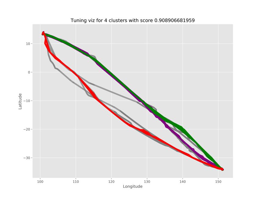
vehicle motion trajectories based on hierarchical clustering;                    TABLE I: The Benchmark Methodologies
including two steps: trajectories preprocessing and resampling                      Step                       Methods
at the first step, then carrying out the trajectories spectral
                                                                                    Trajectory data            Radar track
clustering based on similar spatial patterns at the second                          Distance between curve     Fréchet distance
step. To provide a holistic understanding and deep insight                          Clustering                 DBSCAN
into this interesting topic, a comprehensive survey of the                          Decide Number of Cluster   Silhouette Score
development of trajectory clustering was proposed in [3]. From
this, the authors group the existing trajectory clustering meth-
ods into three categories: unsupervised, supervised and semi-        receive the robust results. Regarding to trajectory clustering
supervised algorithms based on machine learning perspectives.        evaluation, most of the works ( [5], [7], [9], and [17]) preferred
They also show the appearance of different trajectory data           to use Silhouette score alone for choosing the best number
in many modern intelligent systems for surveillance security,        of clusters. Another combination from the work of Bombelli
abnormal behavior detection, crowd behavior analysis, and            and the team [8] leveraged three different indices which is
traffic control, which has attracted growing attention.              average Silhouette index, Davies-Boulding, and Dun index.
   Regarding to the data sources, Radar Track data was often         And the other work from Maraya and the team [4] combined
used in various works from the literature (see in [4], [5], [6],     Silhouette score and Davies-Bouldin (DB) score.
and [7]). The other work from Bombelli and the team [8]                 Inspired by the above results, we propose to leverage the
used the historical data containing the set of Future ATM            ideas from these analysis in a combination with a simplified
Concept Evaluation Tool (FACET) Track (TRX) file. And                framework, in order to adapt for the case of ADS-B data
from Yulin Lui [9] work, they used the data of the flights’          in air route clustering problem. The paper is organized as
information from FAA Traffic Flow Management System and              follows: In Section I, we discussed about the motivation and
Aviation System Performance Metric. However, as we know              previous works related to this paper. Then the Section II
there are recently three publications ( [10], [11], and [12]) in     presents our proposed framework, in which the considered
the Twelfth USA/Europe Air Traffic Management Research               ADS-B data and appropriate techniques involving in the step
and Development Seminar (ATM2017) shared their studies               of data preprocessing will be covered respectively in Section
on ADS-B data. From the work of Junzi and the team                   II-A and II-B. The experimental design and corresponding
[11], they leveraged the large amount of trajectory data for         results taking into account real ADS-B data will be placed
extracting different aircraft performance parameters and they        in Section III. Finally, we come to a conclusion and future
generated different data mining models corresponding to these        works in Section IV.
parameters. While Dhief and the team [10] makes use of the                          II. A PROPOSED FRAMEWORK
ADS-B based systems and can prove their effectiveness in
                                                                        For the main technical part of this paper, we perform the
oceanic area. The United States have plans for mandating
                                                                     trajectory clustering based on DBSCAN [19] approach and
ADS-B Out by 2020 for all airplanes, both air transport and
                                                                     ADS-B data, then combine two different evaluation indices
general aviation, and FAA expects to improve the operational
                                                                     (Silhouette and DB) for the clustering outputs, which were
performance by using ADS-B based systems. These kinds of
                                                                     used to support the visual inspection step. The detail flow of
system are increasing around the world and applying ADS-B
                                                                     our framework are shown in Figure 1, in which the flow com-
data is an essential requirement for all aircraft operating on
                                                                     poses four different phases including Data Extraction, Data
the European, Canadian, and Australian in NAS since 2015
                                                                     Processing, Clustering, and Visual Inspection. Additionally,
[10]. Besides, there are several investigations about the quality
                                                                     the detail description of involved techniques for each step
of ADS-B data such as [13], [14], [15], [12]. Busyairah and
                                                                     in the framework can be found in the Table II. Finally, for
the team [14] proposed a framework for evaluating ADS-B
                                                                     a comparison, all experiments are carried out by using the
data in the London Terminal Maneuvering Area, the result
                                                                     same data, on specific dates, and for particular pairs of origin
showed that 66.7% of aircraft meet the requirement in term of
                                                                     and destination airports. For a benchmark, we re-implement
accuracy, integrity, latency, availability, and update rate. Espe-
                                                                     the route clustering framework from Adria [17], which is
cially, Rekkas and the team [15] and Barsheshat [13] showed
                                                                     summarized the used methodologies in the Table I, considering
similar results, in which their evaluation results considering
                                                                     the same assumption for both of their system and ours.
ADS-B performance are very positive. Barsheshat [13] also
stated that implementing an ADS-B system provides many               A. Data Description
benefits, including the reduction for the need of maintaining           All flights’ trajectories data related to this paper are crawled
and/or upgrading radar infrastructure.                               from FlightAware1 , the company operates a website and mo-
   For the behind techniques, an extensive comparative study         bile application which offers free flight tracking services for
of cluster validity indices has been carried out by Arbelaitz        both private and commercial air traffic. FlightAware produces
and the team [16]. They experimented with 30 different cluster       FlightFeeder which is known as a network of ADS-B receiver.
validity indices with the goal is to choose the best index for       The message consisting of the ADS-B data is received from
each individual application. From their work, the authors also
recommend to employ several indices at the same time to                1 https://flightaware.com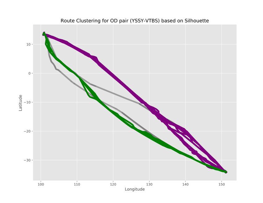
Fig. 1: The detail flow of our proposed framework for air route clustering based on ADS-B data
                                                             .

                                                      (a) Original Trajectories

                                                    (b) Interpolated Trajectories

Fig. 2: The Visualization of Trajectories in Data Processing Step performed by our framework. Figures 2a is done by using
original trajectories up to 2057 spaced points. Figures 2b showed the interpolated trajectories with only 100 spaced points

airplane transponders directly via a small antenna. Then the        GNSS (global navigation satellite system) or GPS receivers.
ADS-B data is extracted from the received messages and              Then it broadcasts the its position and velocity via ADS-B
uploaded to FlightAware’s server over any available internet        Out to other airplanes and ground ADS-B receivers. Ulti-
connection. For carrying out the analysis, we are going to          mately, the receivers around the world send this information
employ only the flight trajectory data from three different         to FlightAware’s servers over a real-time connection.
Origin and Destination pairs of airport, which are shown
clearly in the Table III. The chosen flights for this analysis      B. Data Processing
are collected for entire January 2017.                                 After receiving raw traffic data in JSON format, firstly the
   Here, the whole process of data generation involves of satel-    data standardization steps were employed by grouping traffic
lites, transmitters, and receivers. The airplane determines its     flights and converting them to CSV format, that can be con-
own position and velocity by communicating with satellites via      sumed for other tasks such as EDA (exploratory data analysis),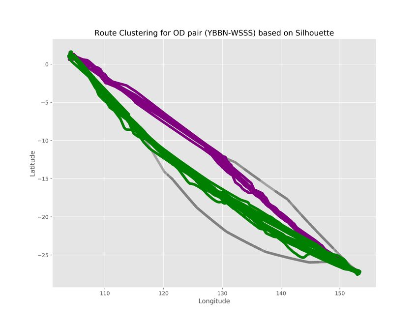
Fig. 3: The result from benchmark method discussed in [17], adapted to ADS-B data. Here, each color represents for each
cluster while the grey color is always used to represent for detected outlier trajectories

     TABLE II: Trajectories Flow Clustering Description                                 TABLE III: Origin Destination Pair Summary
            Step                                Description                         Codename       Airports              Cities
 1.1 Traffic Data Extraction    Received raw traffic data in JSON format            YBBN-WSSS      Brisbane-Changi       Brisbane-Singapore
 1.2 Data Standardization       Group traffic data to identified flights and        YSSY-VTBS      Sydney-Suvarnabhumi   Sydney-Bangkok
                                convert to CSV format                               NZCH-WSSS      Christchurch-Changi   Christchurch-Singapore
 2.1 Flight Traffic Filtering   Filter out the unwanted airports, remove
                                flights that land or depart outside of termi-
                                nal, and drop the duplicated data points
 2.2 Flight Traffic Interpo-    Convert individual flight’s tracks into vec-    2b then visualize the interpolated trajectories, which are able
 lation                         tors of equal length. Apply the cubic spline
                                [18] to interpolate the spaced data points
                                                                                to represent the entire flight’s path with a pre-defined number
 2.3 Dissimilarity Matrix       Measure the dissimilarities between flight      of spaced points.
 Construction                   paths with the same number of features by
                                computing Fréchet distance                                    III. E XPERIMENTAL R ESULTS
 3.1 Parameters Generation      The clustering algorithm replied on two
                                input parameters are ε (a distance threshold)      This section intents to show the major results obtained
                                and MinPts (a minimum number of points).
                                100 values of ε were generated and MinPts       from reimplementing the benchmark method from Aria [17]
                                was retrieved by observations                   in case of our adaptation for ADS-B data, and incorporating
 3.2 Flight Path Clustering     Apply a density-based clustering algorithm      our framework’s application with human intervention in the
                                called DBSCAN with defined MinPts and ε
 3.3 Quality of Clusters        Silhouette and Davies-Bouldin indices were      visual inspection step. Specifically, a density-based clustering
 Measurement                    combined for measuring the clustering per-      algorithm called DBSCAN is taken into account in the Flight
                                formance                                        Path Clustering step. The DBSCAN algorithm receives two
 3.4 Log files Storage          Record all the performances and were pro-
                                duced for each parameter                        primary parameters (MinPts and ) to cluster the trajectory
 4.1 Clustering Result          Visualize the detected clusters along with      data, where the MinPts is the minimum number of data points
                                original and interpolated trajectories          belong to a cluster determined by the actual observation, and
 4.2 Visual Analysis            Analyze the clustering outcome with the
                                recommended ranking from step 3.3, 3.4,          is a distance threshold. In this experimental setting, we
                                and incorporate with human judgment             generated 100 values for  combined with the real observed
 4.3 Decision Making            Make the decision by virtue of domain           MinPts value for running the DBSCAN algorithm. The best
                                expert
                                                                                parameters is determined by using two evaluation stages,
                                                                                quantitative metrics including Silhouette and DB (known as
                                                                                cluster validity indices), and a qualitative validation in visual
data processing, and data clustering. Secondly, in order to                     inspection phase.
make sure the clustering algorithm consuming qualified data,                       In Figure 2, we make a visual comparison of the flight paths
the flight traffic filtering step was executed, including filter                based on original trajectories and interpolated trajectories from
out the unwanted pairs of origin and destination terminals,                     three different pairs of airports (see Table III), in which you
remove flights that land or depart at the coordinates outside                   can see that only using 100 spaced points we could describe
of terminals, and drop the duplicated data points. The Figure                   the whole flight paths between two airports. Next, the Figure
2a show visually the original trajectories after filtering step.                3 shows the final clusters of flight paths for three different
Finally, by virtue of flight traffic interpolation, each individual             pairs of airports, in which the highest Silhouette score is
flight’s trajectories will be converted into vector of equal                    selected as best result. Here, each color represents for each
length. We then apply the cubic spline interpolation [18] to                    cluster while the grey color is always used to represent for
the spaced data points with the assumption that the spatial and                 detected outlier trajectories in this analysis. In our framework,
temporal dimensions are used here in the phase. The Figure                      to obtain more robust results we combine two different indices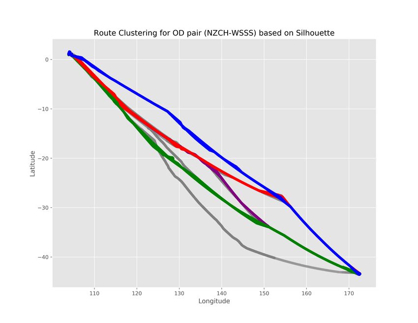
TABLE IV: The Summary of Proposed Framework
                                                                         Pair of Airports         NZCH-WSSS     YBBN-WSSS    YSSY-VTBS
                                                                         No. Flight Path                43         152           94
                                                                         No. Original Trajec-         65102       169545       135586
                                                                         tories
                                                                         No. Interpolated Tra-         4300       15200         9400
                                                                         jectories
                                                                         MinPts                             2      30             3
                                                                         Epsilon                       0.523      1.583         0.603
                                                                         Noise      Percentage         30.00       2.98         18.87
                                                                         (%)
                                                                         No. Clusters via                   4       2             2
                                                                         Quantitative Metric
                                                                         No. Clusters via Vi-               4       2             3
                                                                         sual Inspection

(a) Best air route clustering result based on single Silhouette index
                                                                        for measuring the performance of clustering algorithm. In
                                                                        particular, the Silhouette [20] and Davies-Bouldin (DB) [21]
                                                                        indices are employed altogether to select the best clustering
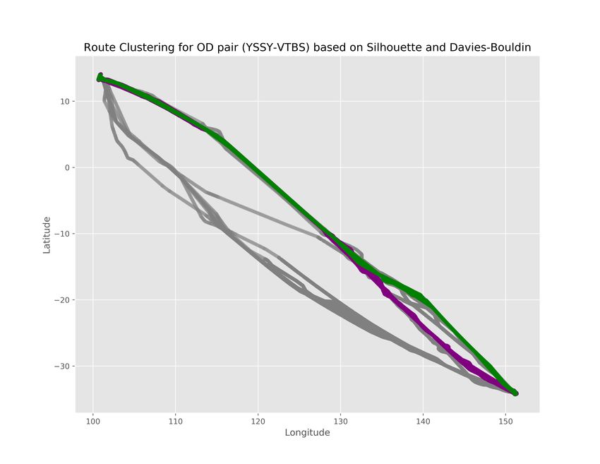
                                                                        result, in the event of these two indices all agree in choosing
                                                                        the most appropriate route clusters that supports strongly for
                                                                        decision making. On the other hand, when the Silhouette index
                                                                        and combined Silhouette-DB index show different rankings
                                                                        (see in Figure 4a and Figure 4b), the visual inspection step
                                                                        will be activated to help the user makes the final decision on
                                                                        air route clustering (see Figure 4c).
                                                                           Last but not least, after clustering the routes into particular
                                                                        clusters, we then employ a simple route matching technique
                                                                        to aggregate all flights’ paths in each cluster into unique
                                                                        route that represents for the air route of each pair of airports
                                                                        (see the Figure 5). This visualization, once employed in real
                                                                        application, will act as a visual suggestion for Airline Route
                                                                        Planning. In summary, a statistical report of the most important
 (b) Best air route clustering result based on Silhouette-DB index      information from our framework are put in the Table IV, taking
                                                                        into account the experiments in three pairs of airports.
                                                                                                  IV. C ONCLUSIONS
                                                                           Based on the potentials and advantages of ADS-B data ,we
                                                                        propose in this paper a simplified and workable framework for
                                                                        air trajectories clustering which is one of the essential parts in
                                                                        the air management process. To our best knowledge, there is a
                                                                        lack of in-depth analytical study from machine learning based
                                                                        approach, with emphasis on this promising data technology.
                                                                        The experimental results, carried out using the data of three
                                                                        different pairs of airports, can show the effectiveness of our
                                                                        proposed framework, as well as the clustering results based on
                                                                        the combination of two different metrics. Finally, from using
                                                                        the interpolation considered in the framework, it is able to
                                                                        reduce significantly the complexity of data processing, which
                                                                        is very important in real application. The whole framework’s
                                                                        source code is made available in github2 . In this direction for
(c) Best air route clustering result based on Visual Inspection step
                                                                        the future research, we are going to consider the framework’s
                                                                        extension to generate predictive capabilities in measuring the
Fig. 4: Our framework’s result for the detected clusters from             2 https://github.com/quandb/atc
different scenarios, in case of Sydney-Suvarnabhumi airports
operation performance in air traffic management. Furthermore,
we also aim to provide guidance and auto-generate inputs for
real time decision support system.
R EFERENCES
[1] S. Gaffney and P. Smyth, “Trajectory clustering with mixtures of
regression models,” in Proceedings of the Fifth ACM SIGKDD
International Conference on Knowledge Discovery and Data Mining,
ser. KDD ’99. New York, NY, USA: ACM, 1999, pp. 63–72. [Online].
Available: http://doi.acm.org/10.1145/312129.312198
[2] Z. Fu, W. Hu, and T. Tan, “Similarity based vehicle trajectory clustering
and anomaly detection,” in IEEE International Conference on Image
Processing 2005, vol. 2, Sep. 2005, pp. II–602.
[3] J. Bian, D. Tian, Y. Tang, and D. Tao, “A survey on trajectory clustering
analysis,” arXiv preprint arXiv:1802.06971, 2018.
[4] M. Conde Rocha Murca, R. DeLaura, R. J. Hansman, R. Jordan,
T. Reynolds, and H. Balakrishnan, ser. AIAA AVIATION Forum.
American Institute of Aeronautics and Astronautics, Jun 2016,
(a) Aggregated Routes in case of Christchurch-Changi airports ch. Trajectory Clustering and Classification for Characterization of
Air Traffic Flows, 0. [Online]. Available: https://doi.org/10.2514/6.
2016-3760
[5] A. Eckstein, “Automated flight track taxonomy for measuring benefits
from performance based navigation,” in 2009 Integrated Communica-
tions, Navigation and Surveillance Conference, May 2009, pp. 1–12.
[6] W. J. Eerland and S. Box, ser. AIAA SciTech Forum. American
Institute of Aeronautics and Astronautics, Jan 2016, ch. Trajectory
Clustering, Modeling and Selection with the focus on Airspace
Protection, 0. [Online]. Available: https://doi.org/10.2514/6.2016-1411
[7] M. Gariel, A. N. Srivastava, and E. Feron, “Trajectory clustering and
an application to airspace monitoring,” IEEE Transactions on Intelligent
Transportation Systems, vol. 12, no. 4, pp. 1511–1524, Dec 2011.
[8] A. Bombelli, A. Segarra Torne, E. Trumbauer, and K. D. Mease,
Automated Route Clustering for Air Traffic Modeling, ser. AIAA
SciTech Forum. American Institute of Aeronautics and Astronautics,
Jan 2017, 0. [Online]. Available: https://doi.org/10.2514/6.2017-1318
[9] Y. Liu, M. Hansen, D. J. Lovell, C. Chuang, M. O. Ball, and J. Gulding,
“Causal analysis of en route flight inefficiency-the us experience,” in
Twelfth USA/Europe Air Traffic Management Research and Development
Seminar, vol. 570, 2017.
[10] I. Dhief, N. E. Dougui, D. Delahaye, and N. Hamdi, “Strategic planning
of North Atlantic Oceanic air traffic based on a new wind-optimal route
structure,” in ATM Seminar, 12th USA/Europe Air Traffic Management
(b) Aggregated Routes in case of Brisbane-Changi airports R&D Seminar, Seattle, United States, Jun. 2017. [Online]. Available:
https://hal-enac.archives-ouvertes.fr/hal-01592231
[11] J. H. Junzi Sun, Joost Ellerbroek, “Modeling Aircraft Performance
Parameters with Open ADS-B Data,” in ATM Seminar, 12th USA/Europe
Air Traffic Management R&D Seminar, Seattle, United States, Jun. 2017.
[12] T. Verbraak, J. Ellerbroek, J. Sun, and J. Hoekstra, “Large-scale ads-b
data and signal quality analysis,” in Proceedings of the 12th USA/Europe
Air Traffic Management Research and Development Seminar, 2017.
[13] A. A. Barsheshat, “Implementation of ads-b systems — benefits and
considerations,” in Proceedings of ESAV’11, Sept 2011, pp. 197–201.
[14] B. S. Ali, A. Majumdar, W. Y. Ochieng, and W. Schuster, “Ads-b: the
case for london terminal manoeuvring area (ltma),” 2013.
[15] C. Rekkas and M. Rees, “Towards ads-b implementation in europe,” in
2008 Tyrrhenian International Workshop on Digital Communications -
Enhanced Surveillance of Aircraft and Vehicles, Sept 2008, pp. 1–4.
[16] O. Arbelaitz, I. Gurrutxaga, J. Muguerza, J. M. Pérez, and I. Perona,
“An extensive comparative study of cluster validity indices,” Pattern
Recognition, vol. 46, no. 1, pp. 243 – 256, 2013. [Online]. Available:
http://www.sciencedirect.com/science/article/pii/S003132031200338X
[17] A. S. Torne, “Route clustering for strategic planning in air traffic
management,” Master dissertation, University of California, Irvine,
Open Access Publications from the University of California, 2015.
[Online]. Available: https://escholarship.org/uc/item/0jb7748c
(c) Aggregated Routes in case of Sydney-Suvarnabhumi airports [18] P. Dierckx, “A fast algorithm for smoothing data on a rectangular
grid while using spline functions,” SIAM Journal on Numerical
Analysis, vol. 19, no. 6, pp. 1286–1304, 1982. [Online]. Available:
Fig. 5: Aggregated Routes as a final output of our framework http://www.jstor.org/stable/2157211[19] M. Ester, H.-P. Kriegel, J. Sander, and X. Xu, “A density-based
algorithm for discovering clusters in large spatial databases with noise,”
in Proc. 2nd Int. Conf. on Knowledge Discovery and Data Mining,
ser. KDD’96. AAAI Press, 1996, pp. 226–231. [Online]. Available:
http://dl.acm.org/citation.cfm?id=3001460.3001507
[20] P. J. Rousseeuw, “Silhouettes: A graphical aid to the interpretation
and validation of cluster analysis,” Journal of Computational and
Applied Mathematics, vol. 20, 1987. [Online]. Available: http:
//gen.lib.rus.ec/scimag/index.php?s=10.1016/0377-0427(87)90125-7
[21] D. W. Davies, David L.; Bouldin, “A cluster separation measure,”
IEEE Transactions on Pattern Analysis and Machine Intelligence, vol.
PAMI-1, 1979. [Online]. Available: http://gen.lib.rus.ec/scimag/index.
php?s=10.1109/tpami.1979.4766909You can also read


