Analysis of the MODIS above-cloud aerosol retrieval algorithm using MCARS
←
→
Page content transcription
If your browser does not render page correctly, please read the page content below
Geosci. Model Dev., 15, 1–14, 2022
https://doi.org/10.5194/gmd-15-1-2022
© Author(s) 2022. This work is distributed under
the Creative Commons Attribution 4.0 License.

Analysis of the MODIS above-cloud aerosol
retrieval algorithm using MCARS
Galina Wind1,2 , Arlindo M. da Silva2 , Kerry G. Meyer2 , Steven Platnick2 , and Peter M. Norris3,2
1 SSAI, Inc. 10210 Greenbelt Road, Suite 600, Lanham, MD 20706, USA
2 NASA   Goddard Space Flight Center, 8800 Greenbelt Rd. Greenbelt, MD 20771, USA
3 Universities Space Research Association, 7178 Columbia Gateway Dr., Columbia, MD 21046, USA

Correspondence: Galina Wind (gala.wind@nasa.gov)

Received: 20 January 2021 – Discussion started: 28 May 2021
Revised: 10 November 2021 – Accepted: 22 November 2021 – Published: 4 January 2022

Abstract. The Multi-sensor Cloud and Aerosol Retrieval           range within the cloud bow was excluded, MOD06ACAERO
Simulator (MCARS) presently produces synthetic radi-             retrievals agreed with the underlying ground truth (GEOS-5
ance data from Goddard Earth Observing System version            cloud and aerosol profiles used to generate the synthetic ra-
5 (GEOS-5) model output as if the Moderate Resolu-               diances) with a slope of 0.913, offset of 0.06, and RMSE =
tion Imaging Spectroradiometer (MODIS) were viewing a            0.107. When only near-nadir pixels were considered (view
combination of atmospheric column inclusive of clouds,           zenith angle within ±20◦ ) the agreement with source data
aerosols, and a variety of gases and land–ocean surface          further improved (0.977, 0.051, and 0.096 respectively). Al-
at a specific location. In this paper we use MCARS to            gorithm closure was examined using a single case out of the
study the MODIS Above-Cloud AEROsol retrieval algo-              five used for verification. For closure, the MOD06ACAERO
rithm (MOD06ACAERO). MOD06ACAERO is presently a                  code was modified to use GEOS-5 temperature and moisture
regional research algorithm able to retrieve aerosol opti-       profiles as an ancillary. Agreement of MOD06ACAERO re-
cal thickness over clouds, in particular absorbing biomass-      trievals with source data for the closure study had a slope of
burning aerosols overlying marine boundary layer clouds in       0.996 with an offset of −0.007 and RMSE of 0.097 at a pixel
the southeastern Atlantic Ocean. The algorithm’s ability to      uncertainty level of less than 40 %, illustrating the benefits of
provide aerosol information in cloudy conditions makes it        high-quality ancillary atmospheric data for such retrievals.
a valuable source of information for modeling and climate
studies in an area where current clear-sky-only operational
MODIS aerosol retrievals effectively have a data gap be-
tween the months of June and October. We use MCARS for           1   Introduction
a verification and closure study of the MOD06ACAERO al-
gorithm. The purpose of this study is to develop a set of con-   The MODerate resolution Imaging Spectroradiometer
straints a model developer might use during assimilation of      (MODIS) (Barnes et al., 1998) has proven to be an important
MOD06ACAERO data.                                                sensor for aerosol data assimilation purposes for models
   Our simulations indicate that the MOD06ACAERO algo-           such as the Goddard Earth Observing System Model,
rithm performs well for marine boundary layer clouds in the      Version 5 (GEOS-5; Rienecker et al., 2008; Molod et al.,
SE Atlantic provided some specific screening rules are ob-       2012). There are two MODIS instruments on board NASA’s
served. For the present study, a combination of five simulated   Earth Observing System (EOS) Terra and Aqua spacecraft.
MODIS data granules were used for a dataset of 13.5 million      There is a wide variety of data products available from these
samples with known input conditions. When pixel retrieval        instruments for land, ocean, and atmosphere disciplines.
uncertainty was less than 30 %, optical thickness of the un-     Atmosphere discipline products include cloud mask, cloud
derlying cloud layer was greater than 4, and scattering angle    top properties, cloud optical and microphysical properties,
                                                                 and atmospheric aerosol properties. The MODIS data

Published by Copernicus Publications on behalf of the European Geosciences Union.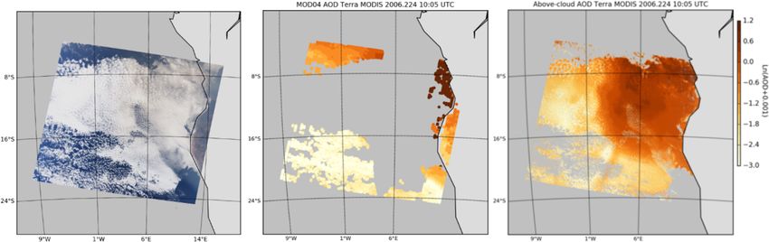
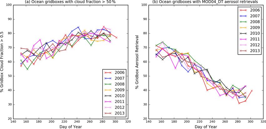
2                          G. Wind et al.: Analysis of the MODIS above-cloud aerosol retrieval algorithm using MCARS

product files use a designation of MOD for Terra MODIS            erage. Recent improvements in CALIPSO version 4 aerosol
and MYD for Aqua MODIS. In this paper for brevity we              products (Kim et al., 2018) indicate that the comparisons
will use “MOD” to refer to both instruments.                      shown of the MOD06ACAERO algorithm with CALIPSO
   The largest contributor of biomass-burning aerosols is         in Meyer et al. (2015) would improve somewhat as sig-
southern Africa (Reid et al., 2009; van der Werf et al., 2010;    nificant work had been done to remedy the low bias that
Chang et al., 2021). Biomass-burning occurring from June          CALIPSO retrievals have. However, Kim et al. (2018) state
through October creates thick smoke plumes that extend over       that the remaining SEA low bias in CALIPSO retrievals of
the adjacent Atlantic Ocean. Prevailing winds in the area         aerosol optical depth (AOD) with respect to AERONET and
transport the smoke over the southeastern Atlantic Ocean          MODIS makes CALIPSO retrievals somewhat problematic
(SEAO) and then as far as the Americas (Swap et al., 1996).       as a means of aerosol algorithm evaluation for SEAO area
The same time period coincides with a near-persistent layer       (e.g., Meyer et al., 2013, 2015; Jethva et al., 2014). Ob-
of marine boundary-layer (MBL) stratus cloud that extends         servations collected during the ObseRvations of Aerosols
for several hundred kilometers westward from the Namib-           above CLouds and their IntEractionS (ORACLES) (Rede-
ian coast (Devasthale and Thomas, 2011). The MODIS Dark           mann et al., 2021) are currently being used to evaluate the
Target aerosol retrieval algorithm (MOD04) that is used           MOD06ACAERO algorithm. Additional descriptions of OR-
for ocean retrievals operates in clear-sky conditions only.       ACLES aerosol data can be found in LeBlanc et al. (2020)
MOD04_DT retrievals are not provided for each individual          and Pistone et al. (2019).
MODIS pixel level, but rather are performed over a 3 × 3 or          In this study we applied an Observing System Simulation
10 × 10 set of pixels. Moreover aerosol properties are not re-    Experiment (OSSE) framework to gain insight into the per-
trieved over sun glint regions (Kaufman et al., 1997; Levy et     formance of the MOD06ACAERO algorithm. Rather than
al., 2009, 2013). The SEAO region has both extensive sea-         using the classic analysis–forecast error metric common in
sonal cloud cover and a significant portion of MODIS gran-        numerical weather prediction OSSE studies (e.g., Hoffman
ules containing sun glint, leading to equally extensive loss of   and Atlas, 2016), we adopt here a “retrieval OSSE” perspec-
continuous observations from the area.                            tive where the quality of the retrieval is used as the verifi-
   Figure 1 illustrates these conditions using Terra MODIS        cation metric (Wind et al., 2013, 2016). A radiative transfer
data from 2006 through 2013. Figure 1a shows the percent-         code is applied to the model quantities combined with sen-
age of ocean grid boxes in the SEAO area that had daily mean      sor geometry to simulate how a model scene appears to a
cloud fraction greater than 50 % in the MODIS Daily Level-        specific instrument. A retrieval algorithm designed for that
3 gridded product (Hubanks et al., 2019) stored at 1◦ × 1◦        instrument can be executed on the simulated measurements.
resolution. Here, the SEAO area is defined the same way as        Physical quantities retrieved by the algorithm can be com-
in Meyer et al. (2015), specifically between −20 and +20◦         pared to the known simulation input. The algorithm can be
longitude and +4 to −20◦ longitude. As much as 60 % of            examined for closure over a large spatial domain, and thus
all ocean grid boxes have cloud fraction greater than 50 %        any areas or conditions that may be problematic for the algo-
in June (day 152) and only increase to the end of Septem-         rithm could be examined, and the strengths and limitations
ber (day 304). A 1◦ -resolution grid box will contain some        of the algorithm can be extensively documented.
clear sky, and thus at least some aerosol retrievals are pos-        The Multi-sensor Cloud and Aerosol Retrieval Simulator
sible. As shown in Fig. 1b, in June between 70 %–80 % of          (MCARS) is a tool that combines model output with a radia-
all ocean grid boxes contain some aerosol retrievals, though      tive transfer code in order to simulate radiances that may be
by September that number drops to between 30 %–50 % year          measured by a remote-sensing instrument if it were passing
over year.                                                        over the model fields (Wind et al., 2013, 2016). In this pa-
   Due to aforementioned limitations of the standard Dark         per, MCARS continues to use the combination of the GEOS-
Target MODIS aerosol algorithm, a model that assimilates          5 model, correlated-k models of atmospheric transmittance
aerosol data from SEAO would have very few aerosol re-            due to various gaseous absorbers for MODIS channels as
trievals over the ocean available to it. Most of the trans-       per Kratz (1995), inline Rayleigh scattering and the Dis-
port mechanism in the model would be thus governed by             crete Ordinate Radiative Transfer (DISORT) code (Stamnes
the model physical processes (e.g., advection, sedimentation      et al., 1988) to simulate MODIS radiances. Two improve-
and wet removal and vertical transport) instead of being con-     ments have been made to the MCARS code since the last
strained by observations.                                         publication. The computational resolution has been increased
   The MOD06ACAERO algorithm (Meyer et al., 2015) fills           to 32 streams, up from 16. Additionally, for this study the
in the aerosol data gap in SEAO as it is able to perform          higher-resolution 7 km GEOS-5 Nature Run (G5NR) was
retrievals of aerosol properties above MBL clouds. The al-        used in place of the standard 25 km resolution GEOS-5 out-
gorithm has been evaluated against observations from the          put (Gelaro et al., 2015; da Silva et al., 2014; Putman et al.,
Cloud-Aerosol Lidar and Infrared Pathfinder Satellite Obser-      2015). G5NR is a 2-year global, non-hydrostatic mesoscale
vation (CALIPSO) (Winker et al., 2009), but CALIPSO only          model dataset for the period 2005/2006 produced with the
provides data at nadir and with a very limited spatial cov-       GEOS-5 Atmospheric General Circulation Model (GCM).

Geosci. Model Dev., 15, 1–14, 2022                                                    https://doi.org/10.5194/gmd-15-1-2022
G. Wind et al.: Analysis of the MODIS above-cloud aerosol retrieval algorithm using MCARS                                          3

Figure 1. Terra MODIS Level-3 Daily 1-degree gridded product for SEAO area for years 2006–2013. Panel (a) shows the percentage of
SEAO ocean grid boxes that had cloud fraction greater than 50 %. Panel (b) shows the percentage of SEAO ocean grid boxes that had any
successful MOD04DT aerosol property retrievals of any quality.

The model run is performed at a horizontal resolution of 7 km        2   MCARS description
using a cubed-sphere horizontal grid with 72 vertical lev-
els, extending up to 0.01 hPa (∼ 80 km). In addition to stan-        The MCARS code was previously described in detail in
dard meteorological parameters (wind, temperature, mois-             Wind et al. (2013, 2016). Therefore, only a brief descrip-
ture, surface pressure), this GCM includes 15 aerosol tracers        tion will be given here. Global aerosol, cloud, surface, and
(dust, sea salt, sulfate, black and organic carbon), O3 , and        atmospheric column fields from the G5NR simulation as de-
CO2 . The GEOS-5 NR is driven by prescribed sea-surface              scribed above serve as the starting point for radiance simula-
temperature and sea ice, daily volcanic and biomass-burning          tions. The GOCART bulk aerosol scheme currently used in
emissions, as well as high-resolution inventories of anthro-         the G5NR is used for the simulations reported in this paper,
pogenic sources. A description of the GEOS-5 model config-           with corresponding optical properties as described in Ran-
uration used for the Nature Run can be found in Putman et            dles et al. (2017), Hess et al. (1998), and references within.
al. (2014), while results from a validation exercise appear in       The simulation input data were produced in accordance with
Gelaro et al. (2015) and Castellanos et al. (2019).                  the methods outlined in Wind et al. (2016). The G5NR model
   In a previous study of the MOD04_DT code (Wind et                 output was split into 1 km subcolumns (MODIS pixel reso-
al., 2016), we had the advantage of having simultaneous in           lution) using the independent column approximation method
situ aerosol property measurements from AErosol RObotic              as described in detail in Wind et al. (2013). Here a brief sum-
NETwork (AERONET) (Holben et al., 1998). AERONET                     mary of the model data preparation methodology is given.
has very limited data available over ocean, mainly from is-             MODIS pixels for each GEOS-5 grid box were collected,
lands and ship transits. Even in places where AERONET is             and the same number of pixel-like subcolumns was generated
established, no measurements can be obtained in presence of          using a statistical model of subgrid column moisture variabil-
clouds. Therefore, no ground-based in situ measurements can          ity. The subcolumn generation used a parameterized proba-
be included in our analysis of the MOD06ACAERO product               bility density function (PDF) of total water content for each
and so the analysis is necessarily limited to verification and       model layer and a Gaussian copula to correlate these PDFs in
closure.                                                             the vertical (Norris et al., 2008; Norris and da Silva, 2016a,
   In sections that follow we will describe the application of       b).
MCARS to study the MOD06ACAERO algorithm. Section 2                     The subcolumns generated in this way were subsequently
very briefly describes the MCARS code and the experiment             rearranged, to give horizontal spatial coherence, by using
setup. Section 3 describes the MODIS MOD06ACAERO                     a horizontal Gaussian copula applied to a condensed water
product of Meyer et al. (2015). Section 4 shows the details          path. This arrangement had to be applied in order to cre-
of the study and study conclusions. Finally, Sect. 5 discusses       ate spatially coherent cloud-like structures. The subcolumns
the next steps in MCARS development.                                 themselves were not altered in any way during this process.
                                                                     If this step is skipped and the subcolumns are placed ran-
                                                                     domly within each grid box, the MODIS Cloud Optical and

https://doi.org/10.5194/gmd-15-1-2022                                                         Geosci. Model Dev., 15, 1–14, 2022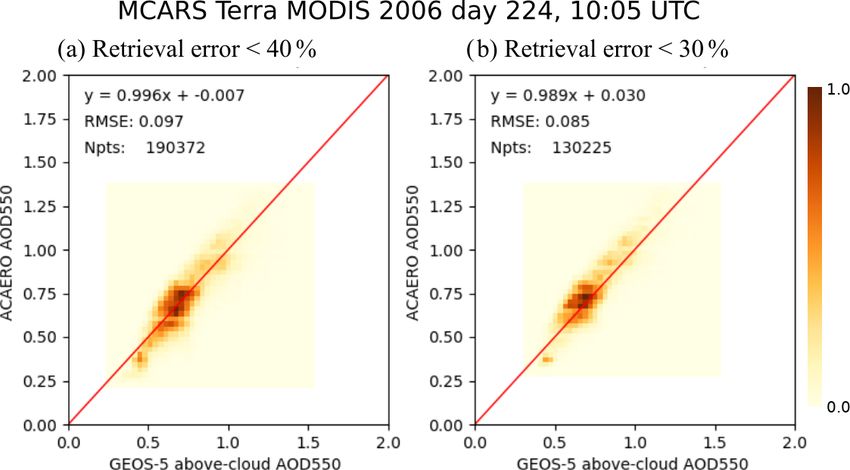
4                          G. Wind et al.: Analysis of the MODIS above-cloud aerosol retrieval algorithm using MCARS

Microphysical Properties (MOD06) product (Platnick et al.,        wavelengths of 0.47, 0.55, 0.66, 0.86, 1.24, and 2.1 µm. The
2017) would restore many of the pixels to clear sky unless        MOD06ACAERO algorithm takes advantage of the strong
the initial grid box had close to 100 % cloud fraction (Zhang     biomass-burning aerosol absorption gradient in the visible
and Platnick, 2011; Pincus et al., 2012). The MOD06 prod-         (VIS) to near-infrared (NIR) spectrum that, when the aerosol
uct is a necessary input for MOD06ACAERO and must be              layer overlies a bright cloud, yields differential attenuation
produced prior to MOD06ACAERO execution. The need for             (stronger at shorter wavelengths) of the otherwise nearly
this subcolumn rearrangement is significantly lessened when       spectrally invariant top-of-atmosphere cloud reflectance
G5NR is used because the smaller grid boxes are often close       across the VIS–NIR. Sensitivity to cloud optical thickness
to 100 % cloudy especially in MBL regimes, but removing           is localized in the spectral range between 0.47 and 1.24 µm
the method from the model preparation step was not practi-        and is directly related to the magnitude of reflectance, while
cal due to its small impact on execution time and possibility     sensitivity to above-cloud aerosol optical depth is related to
of introducing errors.                                            the spectral slope of the reflectance. The MOD06ACAERO
   The layer aerosol properties were obtained using the inde-     algorithm uses 2.1 µm channel for cloud effective radius
pendent column approximation with the same PDF of total           information. That is also consistent with the principal
water content as used for clouds. A GEOS-5 aerosol species        retrieval contained in the MOD06 product (Platnick et al.,
output file was used in conjunction with aerosol optical prop-    2017)
erties as in Randles et al. (2017). The aerosol phase functions      The MOD06ACAERO retrieval inversion uses an opti-
for each of the 15 species output by GEOS-5 were produced         mal estimation-like approach (Rodgers, 1976) that attempts
and combined on the fly to create a single bulk set of scatter-   to minimize the difference (cost function) between the six
ing properties and Legendre coefficients (Wind et al., 2016).     MODIS reflectance observations and forward-modeled re-
   Model parameters such as profiles of temperature, pres-        flectance that is a function of cloud optical thickness, effec-
sure, ozone, and water vapor together with layer information      tive radius, and above-cloud AOD. However, rather than in-
about clouds and aerosols are combined with solar and view        line radiative transfer calculations, MOD06ACAERO relies
geometry of the MODIS instrument. Surface information is          on a set of pre-computed lookup tables (LUTs) of coupled
also a combination of GEOS-5 information of surface tem-          cloud and above-cloud aerosol reflectance. These LUTs are
perature, snow and sea ice cover and MODIS-derived spec-          generated using the same cloud microphysics models used
tral surface albedo (Moody et al., 2007, 2008). All of these      by MOD06 (Platnick et al., 2017) and the absorbing aerosol
parameters are transferred to the DISORT-5 radiative transfer     model used by MOD04_DT over land surfaces (Levy et al.,
code, and reflectances and radiances in 22 MODIS channels         2013). Retrievals using a second aerosol property model, one
between 470 nm and 14.2 µm are produced. The default com-         based on field campaign data from SAFARI 2000 (Haywood
putational resolution of DISORT-5 has also been increased         et al., 2003), are also available in MOD06ACAERO output.
to 32 streams up from 16 used in the two previous studies.        While these Haywood et al. model retrievals were recom-
Additionally some of the simulations in this study were ex-       mended in Meyer et al. (2015), evaluation during the OR-
ecuted at 64 streams. Final MCARS output is packaged in a         ACLES campaign revealed deficiencies at certain scattering
format identical to the standard MODIS Level-1B radiomet-         angle ranges (Kerry Meyer, personal communication, 2016).
ric files and is thus completely transparent to any operational   Thus, for this study we use the MOD06ACAERO results
or research-level retrieval algorithm code.                       based on the MOD04_DT aerosol models.
   These simulations were produced at the NASA Center for            The MOD06ACAERO retrieval operates at 1 km reso-
Climate Simulations (NCCS) supercomputer. Each complete           lution, compared to the 10 and 3 km MOD04_DT reso-
simulation of a MODIS-like granule requires 5.5 h of wall-        lutions, and simultaneously provides pixel-level estimates
clock time on 300 processors. Computational throughput can        of retrieval uncertainty accounting for known and quantifi-
be increased by limiting the scope of the simulation to fit       able error sources (e.g., radiometry, atmospheric profile er-
a particular investigation. For this study, however, we retain    rors, cloud and aerosol forward model errors) consistent
the full set of channels needed for both cloud and aerosol        with the MOD06 cloud product methodology (Platnick et
research.                                                         al., 2020). Figure 2 shows an example retrieval result from
                                                                  MOD06ACAERO compared to MOD04_DT standard 10 km
                                                                  output. The Terra MODIS granule shown here, from 2006
3   MODIS above-cloud aerosol property product                    day 224 at 10:05 UTC, has extensive cloud cover over the
                                                                  ocean, typical for this season. MOD04_DT provides a very
The MODIS above-cloud aerosol property product                    limited amount of data, localized to the few areas of clear
(MOD06ACAERO) (Meyer et al., 2015) is a regional                  sky, while MOD06ACAERO fills in the above-cloud area.
algorithm able to simultaneously retrieve MBL cloud optical       Shinozuka et al. (2020) suggest that above-cloud aerosol re-
thickness (COT), cloud effective radius, and aerosol optical      trievals are similar to adjacent clear-sky retrievals, and so
depth (AOD) above-cloud in the SEAO region. It uses               clear-sky retrievals could be used as an above-cloud proxy.
six MODIS channels (bands 1–5 and 7) having central               However conditions shown in Fig. 2 are common during the

Geosci. Model Dev., 15, 1–14, 2022                                                    https://doi.org/10.5194/gmd-15-1-2022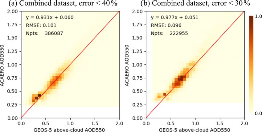
G. Wind et al.: Analysis of the MODIS above-cloud aerosol retrieval algorithm using MCARS 5
SEAO burning season. There are no clear-sky retrievals of are explicitly known. MOD06ACAERO retrievals were at-
aerosol over most of the area due to near uniform coverage by tempted over those points, but of course that does not mean
marine stratus, with cloud fraction approaching 80 %. Near- that each attempt produced a successful aerosol retrieval.
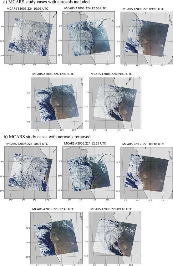
est successful clear-sky retrievals are hundreds of kilometers Figure 3a shows simulated RGB images for the five
away. Therefore an above-cloud aerosol retrieval algorithm MCARS MODIS granules listed above. Also shown in
such as MOD06ACAERO is very much so necessary. Fig. 3b are the same simulated granules where the aerosols
MOD06ACAERO uses National Center for Environmen- have been removed from the radiative transfer simulations.
tal Prediction (NCEP) atmospheric profile products (Derber This ability to remove clouds, aerosols, or gases from the
et al., 1991) for atmospheric correction. As part of our in- simulation offers extensive control evaluating the perfor-
vestigation we will look at impact of discrepancies between mance of retrieval algorithms and diagnosing algorithm defi-
NCEP and G5NR on retrieved aerosol properties. ciencies.
There is a significant similarity between the real Terra
MODIS granule of Fig. 2 and the simulated granule for the
4 Analysis same date and time. The G5NR is a free running model and
does not perform any data assimilation, and therefore it is not
To create the data used for the MOD06ACAERO verifica-
synoptically locked to the particular day depicted in Fig. 2.
tion study, we examined the G5NR dataset for cases that
The apparent similarities between Figs. 2 and 3 merely re-
were similar to conditions commonly encountered during
flect the persistent patterns of MBL clouds and smoke in the
the burning season over SEAO. August 2006 was selected
region. There is no expectation of a match with any real data
because it was a very active smoke season and a signifi-
in this study. It is not a statement to G5NR performance, as
cant number of MBL clouds were present in the model out-
in other cases the cloud amount/distribution had no match to
put. Models often have difficulties forming MBL clouds as
any real data. It is merely an interesting coincidence. Some
higher-than-usual grid and vertical resolution is needed in
granules were selected to include a significant portion of land
order to accurately represent the processes that lead to MBL
surface for a later examination of the MOD04_DT retrievals,
formation in nature.
repeating the study in Wind et al. (2016) in a different region
As real Terra and Aqua overpasses are needed in order
(not reported here).
to define the sun-satellite geometry for the MCARS simu-
This dataset, both the complete and the clean (aerosol-
lations, satellite orbital tracks had to be considered. Because
free) versions, was fed through the standard operational
orbital gaps are prominent in the MODIS data over the SEAO
MODIS Data Collection 6 cloud product processing chain
MBL region, care must be taken in selecting specific days
to produce cloud mask, MOD06 cloud top and opti-
and times having adequate sensor geometry. Technically be-
cal properties, and finally the MOD06ACAERO output
cause MCARS is a simulation, orbital gaps have no meaning.
for each case. Results from all granules were then com-
But because of the need for actual sensor geometry to start
bined, and only retrievals for cloudy pixels were exam-
the simulation, it is most expedient to simply browse avail-
ined. The MOD06ACAERO aerosol retrievals were com-
able MODIS data for a suitable track. Even though G5NR
pared to source aerosol optical depth provided by GEOS-
does not perform any data assimilation, the model code is
5 (Wind et al., 2016). Figure 4 shows results of this com-
identical to the standard GEOS-5 model. MCARS normally
parison. The only constraint on this comparison was that
runs on standard GEOS-5 output. In Wind et al. (2013) we
the algorithm-reported pixel-level retrieval uncertainty had
showed MCARS as a model output verification tool. It is al-
to be less than 40 % for Fig. 4a and less than 30 % for
ways very desirable to match date–time–orbit when model
Fig. 4b. One of the motivations of this study was to char-
performance may be compared to real concurrent sensor
acterize errors in the MOD06ACAERO algorithm for sub-
measurements. Even though no orbital match is required in
sequent aerosol data assimilation into GEOS-5. Pixels with
this study, a decision was made to not alter the standard
higher uncertainties could be considered in the analysis,
MCARS operation in order to avoid accidental introduction
but assimilating data where the retrieval error is 50 % or
of software issues. Five cases were selected under these con-
greater could negatively impact the assimilated fields. As
siderations. Three came from Terra MODIS overpasses and
depicted in Fig. 4, filtering retrievals at the reported algo-
two from Aqua MODIS. The times and dates were as fol-
rithm uncertainty at 40 % is very effective to produce a good
lows:
match between MOD06ACAERO and the G5NR output vari-
– Terra MODIS: 2006 day 224, 10:05 UTC, 2006 day 225 ables, with the exception of very low AODs. G5NR uses
09:10 UTC, 2006 day 228 09:40 UTC; aerosol models described in detail in Randles et al. (2017).
It is a set of 15 absorbers, properties of which are a func-
– Aqua MODIS: 2006 day 224 12:55 UTC and 2006 day
tion of column relative humidity. MOD06ACAERO in this
226 12:40 UTC.
study uses the MOD04_DT aerosol models, which are dis-
This simulated radiance dataset comprises 13.5 million tinct in composition and additionally computed at a constant
points where the atmospheric column and surface conditions 80 % column relative humidity (Levy et al., 2013). Because
https://doi.org/10.5194/gmd-15-1-2022 Geosci. Model Dev., 15, 1–14, 2022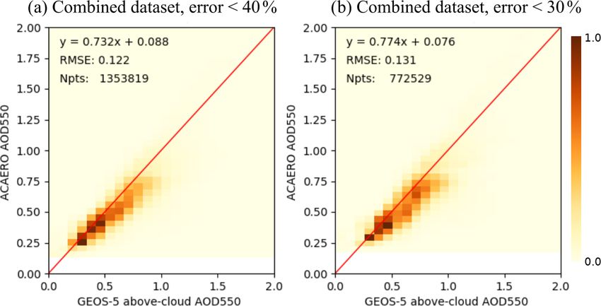
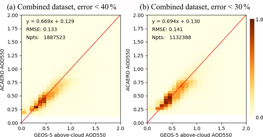
6                            G. Wind et al.: Analysis of the MODIS above-cloud aerosol retrieval algorithm using MCARS

Figure 2. Real-data example of MOD06ACAERO retrieval. Terra MODIS 2006 day 224 10:05 UTC. Panel (a) shows the true-color MODIS
granule. There is extensive aerosol layer above the equally extensive MBL cloud layer. Panel (b) shows the MODIS Data Collection 6
operational Dark Target aerosol retrieval. It is a 10 km resolution product with retrievals available only in clear-sky conditions and outside
glint. Panel (c) shows the MOD06ACAERO above-cloud aerosol retrieval that is able to fill the data gap created by presence of MBL.

G5NR mixes aerosols on the fly to create bulk layer proper-              gle. Retrievals where MOD06ACAERO matched GEOS-5
ties and MOD06ACAERO has a constant regional mixture,                    precisely were discarded for clarity. Within the cloud bow
there is a natural source of uncertainty in any comparison of            MOD06ACAERO tends to return a small positive AOD of
MOD06ACAERO retrievals with G5NR (Chin et al., 2002).                    about 0.15.
However the regional mixture of MOD04_DT had been used                      The liquid water phase function is very complex in the
extensively to train the GOCART model used by both GEOS-                 cloud bow region and is very difficult to model accurately.
5 and G5NR. Thus we expect the uncertainty due to aerosol                That particular region has consistently caused difficulties to
model mismatch to be fairly minimal. The same exact situ-                the standard MOD06 product retrievals of MBL clouds. Both
ation of aerosol mixture mismatch exists in real data and is             MOD06 and MOD06ACAERO LUTs are computed at 64
most likely greater than the one existing in this simulation.            DISORT streams. We performed some investigation of this
Detailed comparison of GOCART and MOD04_DT aerosol                       area by running a special simulation for a single case from
models for biomass-burning aerosols has been performed in                Terra 2006 day 224 10:05 UTC. This case was selected be-
Wind et al. (2016).                                                      cause the cloud bow is especially noticeable in both real
   Meyer et al. (2015) suggest that additionally                         and simulated data. The simulation was also executed using
MOD06ACAERO retrievals should be screened by re-                         64 DISORT streams in order to reduce uncertainties asso-
trieved cloud optical thickness and that they should be                  ciated with the simulation being performed at half the res-
discarded if COT is less than 4.0. We applied this additional            olution. In cloud bow region more streams would poten-
constraint onto the retrieval comparison, and the result is              tially lead to a better model. Unfortunately the cloud bow
shown in Fig. 5. Discarding the AOD retrievals when cloud                persisted. It thus may be the case that 64 streams are not
is thin improved the matchup against GEOS-5, but there still             sufficient to properly resolve the cloud bow in either sim-
appears to be an issue when GEOS-5 AOD is very close to                  ulation or retrieval. Even higher resolution may be advis-
zero.                                                                    able. Increasing computational resolution of MOD06 LUTs
   The power of MCARS lies in being able to tightly con-                 is presently considered for the upcoming MODIS Data Col-
trol simulation parameters. The MOD06ACAERO algorithm                    lection 7. Depending on the results, the same increase may
appears to run into a difficulty at low source AOD. In or-               occur for MOD06ACAERO. At this time, for purpose of es-
der to examine the causes for this discrepancy in more de-               tablishment of assimilation constraints, which is the focus of
tail, we turn our attention to the clean MCARS case shown                this study, one might simply exclude the cloud bow scattering
in Fig. 3b by setting the AOD precisely to zero and exam-                angle range from consideration until more is known.
ining the retrieval performance in such a situation. Ideally                Figure 7 shows the results of MOD06ACAERO retrievals
MOD06ACAERO should retrieve a zero AOD throughout.                       from Fig. 5, where retrievals within the cloud bow have
With an exception of a narrow range of scattering angles be-             been discarded. The comparison with source data is fur-
tween 135 and 145◦ , which corresponds to the cloud bow                  ther improved, and the cluster of MOD06ACAERO retrievals
direction, the algorithm indeed retrieved AOD that was ex-               present in Fig. 5 when GEOS-5 AOD was near zero has dis-
tremely close to zero. Figure 6 depicts the difference be-               appeared.
tween retrieval and source as a function of scattering an-

Geosci. Model Dev., 15, 1–14, 2022                                                              https://doi.org/10.5194/gmd-15-1-2022
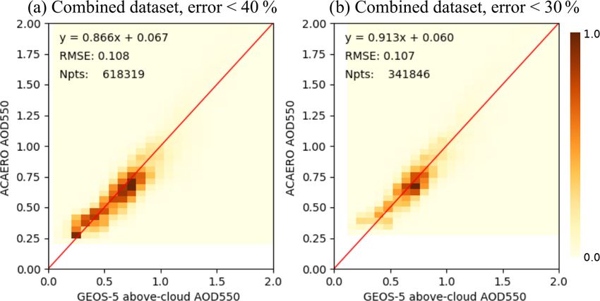
G. Wind et al.: Analysis of the MODIS above-cloud aerosol retrieval algorithm using MCARS                                           7

Figure 3. Scenes generated by MCARS from G5NR used in analysis of the MOD06ACAERO product. There are three cases based on Terra
MODIS, designated with a T next to the year. There are two cases based on Aqua MODIS, designated with an A next to the year. Panel (a)
shows the case set simulated with aerosols present. Panel (b) shows the same case set but simulated with aerosols removed.

https://doi.org/10.5194/gmd-15-1-2022                                                          Geosci. Model Dev., 15, 1–14, 2022
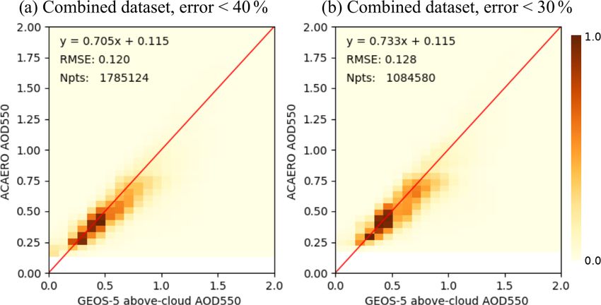
8                          G. Wind et al.: Analysis of the MODIS above-cloud aerosol retrieval algorithm using MCARS

Figure 4. MOD06ACAERO retrieval results from the combined dataset of Fig. 3a compared to source GEOS-5 aerosol optical depth as a
normalized density plot. No screening of retrievals had been performed except for pixel-level uncertainty. Panel (a) shows MOD06ACAERO
retrievals with uncertainty of less than 40 %, and panel (b) shows the same with uncertainty less than 30 %.

Figure 5. MOD06ACAERO retrieval results from the combined dataset of Fig. 3a compared to source GEOS-5 aerosol optical depth as a
normalized density plot. AOD retrievals where COT was less than 4 are now discarded. Panel (a) shows MOD06ACAERO retrievals with
uncertainty of less than 40 %, and panel (b) shows the same with uncertainty less than 30 %.

   Often better retrievals can be obtained when less oblique         ure 8 shows the MOD06ACAERO retrievals of Fig. 7 further
view geometry is considered in real data. Pixel size, longer         limited by view zenith angle of less than 32◦ . When view
optical path length, and 3D effects from clouds can all make         zenith angle is limited to 32◦ the comparison with GEOS-5
retrievals performed at oblique view angles less optimal. In         source data is again improved. We can now show a slope of
the case of this study, another consideration for imposition of      0.866 for retrievals with less than 40 % error and 0.913 for
a view zenith limit is that presently MCARS does not account         retrievals with error of less than 30 %. Note that even though
for pixel size growth at oblique view angles. The number of          the data extent had been limited, there are still over 600 000
subcolumns generated does not change with view zenith an-            data points left to be ingested into a model if data assimi-
gle. Therefore, MCARS results when view angle is oblique             lation were to be attempted in an area where previously the
may not be an accurate measure of algorithm performance as           number of such data points was close to 0.
only the effects of optical path length are simulated.                  We can constrain the view zenith angle range even further
   The MOD06 cloud product outputs cloud top pressure,               as shown in Fig. 9, reducing the threshold to 20◦ . Whereas
temperature, and height limited to near nadir in addition to         the comparison shows all around improvement with slope of
full swath products. The “near nadir” is defined as view-            0.931 and 0.977 for retrieval error of less than 40 % and 30 %
ing zenith angle less than 32◦ (Menzel et al., 2008). Fig-           respectively, the number of points suitable for assimilation

Geosci. Model Dev., 15, 1–14, 2022                                                        https://doi.org/10.5194/gmd-15-1-2022
G. Wind et al.: Analysis of the MODIS above-cloud aerosol retrieval algorithm using MCARS                                              9

Figure 6. MOD06ACAERO retrieval results from the combined dataset of Fig. 3b, where aerosols had been removed. The results are
displayed as difference from GEOS-5 AOD, which in this case was zero, as a function of scattering angle as a normalized density plot. All
retrievals where MOD06ACAERO result was also zero had been removed for clarity. All non-zero MOD06ACAERO retrievals appear to
be concentrated in a narrow angle range between 135 and 145◦ which corresponds to the cloud bow. Panel (a) shows MOD06ACAERO
retrievals with uncertainty of less than 40 %, and panel (b) shows the same with uncertainty less than 30 %.

Figure 7. MOD06ACAERO retrieval results from the combined dataset of Fig. 3a compared to source GEOS-5 aerosol optical depth as a
normalized density plot. AOD retrievals where COT was less than 4 are now discarded. Additionally retrievals in the cloud bow region are
also removed. It appears they were indeed the source of a cluster of higher MOD06ACAERO retrievals when GEOS-5 AOD was near zero
and the matchup with GEOS-5 source AOD is further improved. Panel (a) shows MOD06ACAERO retrievals with uncertainty of less than
40 %, and panel (b) shows the same with uncertainty less than 30 %.

shrinks by half. It is not clear if this dataset size reduction        we use MCARS pixel-level input profiles for atmospheric
can be justified by the improvement in alignment with the              correction. The result is shown in Fig. 10. When atmospheric
source data.                                                           profiles are removed as a source of inconsistency, the agree-
   With the 20◦ view angle constraint the algorithm re-                ment with source data improves to a slope of 0.996 with
sults are very close to source data and we could potentially           intercept of −0.007 and RMSE of 0.097 for retrievals with
state that we have closure against source GEOS-5 data even             less than 40 % error and slope of 0.989, intercept of 0.03
though both MOD06 and MOD06ACAERO run under oper-                      and RMSE of 0.085 for retrievals with less than 30 % er-
ational conditions used NCEP GDAS data for atmospheric                 ror. Small sample size for retrievals with lower uncertainty
correction (implying a likely overestimation of the error in           is the reason for somewhat less agreement with source data
these profiles). In order to assess the impact of using these          for this closure experiment. The remaining source of po-
GDAS-based profiles, we consider a final experiment where              tential disagreement of MOD06ACAERO retrieval with in-

https://doi.org/10.5194/gmd-15-1-2022                                                            Geosci. Model Dev., 15, 1–14, 2022
10                          G. Wind et al.: Analysis of the MODIS above-cloud aerosol retrieval algorithm using MCARS

Figure 8. MOD06ACAERO retrieval results from the combined dataset of Fig. 3a compared to source GEOS-5 aerosol optical depth as a
normalized density plot. AOD retrievals where COT was less than 4 and where the scattering angle was in the cloud bow are now discarded.
Additionally the data extent had been limited to only include pixels with view zenith angle of less than 32◦ . Retrieval comparison shows
further improvement. Panel (a) shows MOD06ACAERO retrievals with uncertainty of less than 40 %, and panel (b) shows the same with
uncertainty less than 30 %.

Figure 9. MOD06ACAERO retrieval results from the combined dataset of Fig. 3a compared to source GEOS-5 aerosol optical depth as a
normalized density plot. AOD retrievals where COT was less than 4 and where the scattering angle was in the cloud bow are now discarded.
Additionally the data extent had been limited to only include pixels with view zenith angle of less than 20◦ . Retrieval comparison shows
further improvement. However, it is not clear if the reduction in dataset size is worth the gain in accuracy. Panel (a) shows MOD06ACAERO
retrievals with uncertainty of less than 40 %, and panel (b) shows the same with uncertainty less than 30 %.

put GEOS-5 data is the difference between aerosol mod-                 Wind et al. (2016). MCARS has the ability to switch between
els used by MCARS and MOD06ACAERO. Cloud mod-                          the GEOS-5 aerosols and those used by MOD06ACAERO
els between MOD06ACAERO and MCARS are identical                        and MOD04DT. We tested part of the dataset with identical
in this study. The MOD06ACAERO model is fixed for the                  aerosol models between retrieval and simulation and found
region, while the GEOS-5 aerosols are fully dynamic as                 there to be no significant impact. One reason for that is simu-
per Randles et al. (2017). However, it is not practical to             lations in Wind et al. (2016) dealt with aerosols located near
change either MCARS or MOD06ACAERO code to use                         sources. These aerosols, even though they are the same basic
a different aerosol model set and with the agreement be-               type, traveled a significant distance from the source and have
ing as good as it presently is. A question might be asked              had a chance to absorb water. Once that happens, there is
as to whether the difference between aerosol models used               no difference in the scattering properties between the aerosol
by MCARS and MOD06ACAERO would be an additional                        model used by MOD04DT and GEOS-5. Part of the reason
source of disagreement, especially in the light of results in          for this specific dataset selection is to also have the cloud-

Geosci. Model Dev., 15, 1–14, 2022                                                          https://doi.org/10.5194/gmd-15-1-2022
G. Wind et al.: Analysis of the MODIS above-cloud aerosol retrieval algorithm using MCARS                                                11

Figure 10. MOD06ACAERO retrieval results from simulated MCARS granule based on Terra MODIS 2006 day 224 10:05 UTC compared
to source GEOS-5 aerosol optical depth as a normalized density plot. In this experiment both MOD06 and MOD06ACAERO were modified
to use MCARS pixel-level atmospheric profiles to perform atmospheric correction. AOD retrievals where COT was less than 4 and where
the scattering angle was in the cloud bow are now discarded. Additionally the data extent had been limited to only include pixels with view
zenith angle of less than 20◦ . This experiment shows excellent agreement with source data. Panel (a) shows MOD06ACAERO retrievals
with uncertainty of less than 40 %, and panel (b) shows the same with uncertainty less than 30 %. The small dataset size in panel (b) is the
reason for slightly lower agreement with source compared to panel (a).

free land present so that we could repeat the experiment in             aerosol optical depth with slope of 0.774 and offset of 0.076,
Wind et al. (2016) on a different continent. We expect over             RMSE = 0.131. On further examination, executing the algo-
land, and thus near sources, that we would absolutely see the           rithm on the same case set with aerosols removed it was de-
impact of differences in single-scattering albedo.                      termined that there might be data that is less useful around
                                                                        the scattering angle of 140◦ , the cloud bow direction. When
                                                                        the cloud bow pixels were excluded the slope improved to
5   Conclusions and future directions                                   0.913. The near-nadir slope with angle limit of 20◦ improved
                                                                        the agreement further to 0.977, RMSE = 0.096.
This paper is a direct evolution of work started in Wind et al.            To look at closure one of the five cases was selected.
(2013) and continued in Wind et al. (2016). The Multi-sensor            For closure both MOD06 and MOD06ACAERO codes were
Cloud and Aerosol Retrieval Simulator (MCARS) has now                   modified to use MCARS input profiles as an ancillary in-
been applied as a verification tool for a research-level algo-          stead of the NCEP analysis used in operations (Platnick et
rithm. The algorithm studied was the MODIS above-cloud                  al., 2017). When the results were compared to source GEOS-
aerosol properties retrieval algorithm of Meyer et al. (2015).          5 data a slope of 0.996 with offset of −0.007 and RMSE =
MCARS computational resolution has been doubled, and for                0.097 was reached for pixels with less than 40 % uncertainty.
this study the high-resolution (7 km) GEOS-5 Nature Run                 The agreement was slightly worse for uncertainties less than
model was utilized. The MCARS code produces radiances                   30 % (slope 0.989, offset 0.03 and RMSE = 0.085), but that
and reflectances in a standard MODIS Level-1B format after              was mainly due to having a smaller number of pixels in the
sending the GEOS-5 data through DISORT-5 radiative trans-               set, only 130 000.
fer code. The output can be directly ingested by any retrieval             The results of this study suggest that retrievals produced
or analysis code that reads data from the MODIS instrument.             by MOD06ACAERO are of good initial quality and would be
   We used the MCARS code to perform verification and clo-              a valuable addition to model data assimilation streams with
sure study on the MOD06ACAERO algorithm. In this study                  the following constraints. MOD06ACAERO pixels should be
we generated a set of five MODIS granules located in the                assimilated if retrieval uncertainly is less than 40 %, if optical
southeastern Atlantic Ocean off the coast of Namibia. We                thickness of the underlying cloud layer is greater than 4.0,
executed the MOD06ACAERO code on this case set. In the                  and if the pixel scattering angle is outside the cloud bow.
verification part of the study the algorithm performed very             Additionally, an even tighter constraint can be added to only
well. When pixels with less than 30 % uncertainty were con-             take pixels that are near nadir.
sidered with underlying cloud layer having optical thickness
greater than 4, the algorithm matched the source GEOS-5

https://doi.org/10.5194/gmd-15-1-2022                                                              Geosci. Model Dev., 15, 1–14, 2022
12 G. Wind et al.: Analysis of the MODIS above-cloud aerosol retrieval algorithm using MCARS
This study is yet another example of the capabilities of the and cloud properties over the southeast Atlantic: An obser-
MCARS framework. There are many other potential applica- vational analysis, Geophys. Res. Lett., 48, e2020GL091469,
tions of the MCARS code, including extending the simulator https://doi.org/10.1029/2020GL091469, 2021.
to other sensors and examining the performance of fast re- Chin, M., Ginoux, P., Kinne, S., Torres, O., Holben, B. N., Duncan,
trieval simulators used in climate modeling. B. N., Martin, R. V., Logan, J. A., Higurashi, A., and Nakajima,
T.: Tropospheric Aerosol Optical Thickness from the GOCART
Model and Comparisons with Satellite and Sun Photometer Mea-
surements, J. Atmos. Sci., 59, 461–483, 2002.
Code and data availability. The MCARS code is free of charge and
da Silva, A. M., Putman, W., and Nattala, J.: File Specification
can be downloaded here: https://doi.org/10.5281/zenodo.5224964
for the 7 km GEOS-5 Nature Run, Ganymed Release (Non-
(Wind et al., 2021).
hydrostatic 7 km Global Mesoscale Simulation), GMAO Office
Note no. 6 (Version 1.0), 176 pp., available at: http://gmao.
gsfc.nasa.gov/pubs/office_notes (last access: 25 February 2020),
Author contributions. GW is the development and experiment de- 2014.
sign lead on the MCARS project. She maintained the code, carried Derber J. C., Parrish, D. F., and Lord, S. J.: The new global op-
out the experiments, and performed most of the analysis of experi- erational analysis system at the National Meteorological Center,
mental data. AMdS and PMN assisted with preparation, interpreta- Weather Forecast., 6, 538–547, 1991.
tion, and integration of the GEOS-5 model data. KGM is the author Devasthale, A. and Thomas, M. A.: A global survey of
of the MODIS above-cloud aerosol retrieval algorithm, the subject aerosol-liquid water cloud overlap based on four years of
of this simulation experiment. He assisted with interpretation of re- CALIPSO-CALIOP data, Atmos. Chem. Phys., 11, 1143–1154,
trieval results and development of assimilation constraints for the https://doi.org/10.5194/acp-11-1143-2011, 2011.
above-cloud aerosol product. SP assisted with analysis, evaluation, Gelaro, R., Putman, W., Draper, C., Molod, A., Norris, P. M., Ott,
and interpretation of all experimental data. L. E., Prive, N., Reale, O., Achuthavarier, D., Bosilovich, M.,
Buchard, V., Chao, W., Coy, L., Cullather, R., da Silva, A. M.,
Darmenov, A., Errico, R. M., Fuentes, M., Kim, M. J., Koster,
Competing interests. The contact author has declared that neither R., McCarty, W., Nattala, J., Partyka, G., Schubert, S., Vernieres,
they nor their co-authors have any competing interests. G., Vikhliaev, Y., and Wargan, K.: Evaluation of the 7 km GEOS-
5 Nature Run, Technical Report, NASA/TM-2014-104606, God-
dard Space Flight Center, National Aeronautics and Space Ad-
Disclaimer. Publisher’s note: Copernicus Publications remains ministration, 2015.
neutral with regard to jurisdictional claims in published maps and Haywood, J. M., Osborne, S. R., Francis, P. N., Keil, A., For-
institutional affiliations. menti, P., Andreae, M. O., and Kaye, P. H.: The mean
physical and optical properties of regional haze dominated
by biomass burning aerosol measured from the C-130 air-
Acknowledgements. The authors would like to thank Brad Wind for craft during SAFARI 2000, J. Geophys. Res., 108, 8473,
the initial idea for creating a simulator, the output of which could https://doi.org/10.1029/2002JD002226, 2003.
be transparently used with remote-sensing retrieval codes. Hess, M., Koepke, P., and Schult, I.: Optical properties of aerosols
and clouds: The software package OPAC, B. Am. Meteorol. Soc.,
79, 831–844, 1998.
Hoffman, R. N. and Atlas, R.: Future Observing System Sim-
Review statement. This paper was edited by Christina McCluskey
ulation Experiments, B. Am. Meteorol. Soc., 97, 1601–1616,
and reviewed by Samuel LeBlanc and two anonymous referees.
https://doi.org/10.1175/BAMS-D-15-00200.1, 2016.
Holben, B. N., Eck, T. F., Slutsker, I., Tanre, D., Buis, J. P., Set-
zer, A., Vermote, E. F., Reagan, J. A., Kaufman, Y. J., Nakajima,
References T., Lavenu, F., Jankowiak, I., and Smirnov, A.: AERONET – A
federated instrument network and data archive for aerosol char-
Barnes, W. L., Pagano, T. S., and Salomonson, V. V.: Prelaunch acterization, Remote Sens. Environ., 66, 1–16, 1998.
characteristics of the Moderate Resolution Imaging Spectrora- Hubanks, P., Platnick, S., King, M. D., and Ridgway, W.:
diometer (MODIS) on EOS-AM1, IEEE T. Geosci. Remote, 36, MODIS Level-3 daily gridded product, available at: https://
1088–1100, 1998. modis-atmos.gsfc.nasa.gov/images/l3-daily-browse (last access:
Castellanos, P., da Silva, A., Darmenov, A., Buchard, V., 16 July 2020), 2019.
Govindaraju, R., Ciren, P., and Kondragunta, S.: A Geo- Jethva, H., Torres, O., Waquet, F., Chand, D., and Hu, Y.: How
stationary Instrument Simulator for Aerosol Observing do A-train sensors intercompare in the retrieval of above-cloud
System Simulation Experiments, Atmosphere, 10, 2–36, aerosol optical depth? A case study-based assessment, Geophys.
https://doi.org/10.3390/atmos10010002, 2019. Res. Lett., 41, 186–192, https://doi.org/10.1002/2013GL058405,
Chang, I., Gao, L., Burton, S. P., Chen, H., Diamond, M. S., 2014.
Ferrare, R. A., Flynn, C. J., Kacenelenbogen, M., LeBlanc, S. Kaufman, Y. J., Wald, A. E., Remer, L. A., Gao, B. C., Li, R. R.,
E., Meyer, K. G., Pistone, K., Schmidt, S., Segal-Rozenhaimer, and Flynn, L.: The MODIS 2.1 µm channel – Correlation with
M., Shinozuka, Y., Wood. R., Zuidema, P., Redemann, J., and
Christopher, S. A.: Spatiotemporal heterogeneity of aerosol
Geosci. Model Dev., 15, 1–14, 2022 https://doi.org/10.5194/gmd-15-1-2022G. Wind et al.: Analysis of the MODIS above-cloud aerosol retrieval algorithm using MCARS 13 visible reflectance for use in remote sensing of aerosol, IEEE T. Norris, P. M. and da Silva, A. M.: Monte Carlo Bayesian inference Geosci. Remote, 35, 1286–1298, 1997. on a statistical model of sub-gridcolumn moisture variability us- Kim, M.-H., Omar, A. H., Tackett, J. L., Vaughan, M. A., Winker, ing high-resolution cloud observations. Part 2: Sensitivity tests D. M., Trepte, C. R., Hu, Y., Liu, Z., Poole, L. R., Pitts, M. C., and results, Q. J. Roy. Meteor. Soc., 142, 2528–2540, 2016b. Kar, J., and Magill, B. E.: The CALIPSO version 4 automated Norris, P. M., Oreopoulos, L., Hou, A. Y., Tao, W.-K., and Zeng, X.: aerosol classification and lidar ratio selection algorithm, At- Representation of 3D heterogeneous cloud fields using copulas: mos. Meas. Tech., 11, 6107–6135, https://doi.org/10.5194/amt- Theory for water clouds, Q. J. Roy. Meteor. Soc., 134, 1843– 11-6107-2018, 2018. 1864, https://doi.org/10.1002/qj.321, 2008. Kratz, D. P.: The correlated-k distribution technique as applied to Pincus, R., Platnick, S., Ackerman, S. A., Hemler, R. S., and Hof- the AVHRR channels, J. Quant. Spectrosc. Ra., 53, 501–517, mann, R. J. P.: Reconciling simulated and observed views of 1995. clouds: MODIS, ISCCP, and the limits of instrument simulators, LeBlanc, S. E., Redemann, J., Flynn, C., Pistone, K., Kacenelen- J. Climate, 25, 4699–4720, https://doi.org/10.1175/JCLI-D-11- bogen, M., Segal-Rosenheimer, M., Shinozuka, Y., Dunagan, S., 00267.1, 2012. Dahlgren, R. P., Meyer, K., Podolske, J., Howell, S. G., Freitag, Pistone, K., Redemann, J., Doherty, S., Zuidema, P., Burton, S., Small-Griswold, J., Holben, B., Diamond, M., Wood, R., For- S., Cairns, B., Cochrane, S., Ferrare, R., Flynn, C., Freitag, menti, P., Piketh, S., Maggs-Kölling, G., Gerber, M., and Nam- S., Howell, S. G., Kacenelenbogen, M., LeBlanc, S., Liu, woonde, A.: Above-cloud aerosol optical depth from airborne X., Schmidt, K. S., Sedlacek III, A. J., Segal-Rozenhaimer, observations in the southeast Atlantic, Atmos. Chem. Phys., 20, M., Shinozuka, Y., Stamnes, S., van Diedenhoven, B., Van 1565–1590, https://doi.org/10.5194/acp-20-1565-2020, 2020. Harten, G., and Xu, F.: Intercomparison of biomass burning Levy, R. C., Remer, L. A., Tanre, D., Mattoo, S., and Kaufman, aerosol optical properties from in situ and remote-sensing instru- Y. J.: Algorithm for remote sensing of tropospheric aerosol over ments in ORACLES-2016, Atmos. Chem. Phys., 19, 9181–9208, dark targers from MODIS Collections 005 and 051, revision 2, https://doi.org/10.5194/acp-19-9181-2019, 2019. ATBD Reference Number: ATBD-MOD-04, available at: http:// Platnick, S., Meyer, K. G., King, M. D., Wind, G., Amarasinghe, N., modis-atmos.gsfc.nasa.gov/reference_atbd.html (last access: 16 Marchant, B., Arnold, G. T., Zhang, Z., Hubanks, P. A., Holz, July 2020), 2009. R. E., Yang, P., Ridgway, W., and Riedi, J: The MODIS Cloud Levy, R. C., Mattoo, S., Munchak, L. A., Remer, L. A., Sayer, A. Optical and Microphysical Products: Collection 6 Updates and M., Patadia, F., and Hsu, N. C.: The Collection 6 MODIS aerosol Examples from Terra and Aqua, IEEE T. Geosci. Remote, 55, products over land and ocean, Atmos. Meas. Tech., 6, 2989– 502–525, https://doi.org/10.1109/TGRS.2016.2610522, 2017. 3034, https://doi.org/10.5194/amt-6-2989-2013, 2013. Platnick, S., Meyer, K. G., Amarasinghe, N., Wind, G., Hubanks, P. Menzel, W. P., Frey, R., Zhang, H., Wylie, D., Moeller, C., Holz, A., and Holz, R. E.: Sensitivity of Multispectral Imager Liquid R. A., Maddux, B., Baum, B. A., Strabala, K., and Gumley, L.: Water Cloud Microphysical Retrievals to the Index of Refraction, MODIS global cloud-top pressure and amount estimation: Algo- Remote Sens., 12, 4165, https://doi.org/10.3390/rs12244165, rithm description and results, J. Appl. Meteorol. Clim., 47, 1175– 2020. 1198, 2008. Putman, W., da Silva, A. M., Ott, L. E., and Darmenov, A.: Model Meyer, K. G. and Platnick, S.: Simultaneously inferring above- Configuration for the 7 km GEOS-5 Nature Run, Ganymed cloud absorbing aerosol optical thickness and underlying liquid Release (Non-hydrostatic 7 km Global Mesoscale Simulation), phase cloud optical and microphysical properties using MODIS, GMAO Office Note no. 5 (Version 1.0), 18 pp., available at: J. Geophys. Res.-Atmos., 120, 5524–5547, 2015. http://gmao.gsfc.nasa.gov/pubs/office_notes (last access: 28 July Meyer, K. G., Platnick, S., Oreopoulos, L., and Lee, D.: Estimating 2020), 2014. the direct radiative effect of absorbing aerosols overlying marine Putman, W. M., Da Silva, A. M., Ott, L. E., and Darmenov, boundary layer clouds in the southeast Atlantic using MODIS A.: Model configuration for the 7-km GEOS-5 Nature Run, and CALIOP, J. Geophys. Res.-Atmos., 118, 4801–4815, 2013. Ganymed release, GMAO Office Note #5 v1.0 NASA-TRS doc- Molod, A., Takacs, L., Suarez, M., Bacmeister, J., Song, I.-S., and ument ID: 20150001445, 2015. Eichmann, A.: The GEOS-5 Atmospheric General Circulation Randles, C. A., da Silva, A. M., and Buchard, V.: The MERRA- Model: Mean Climate and Development from MERRA to For- 2 Aerosol Reanalysis, 1980–onward, Part I: System Description tuna, Tech. Rep. S. Gl. Mod. Data Assim., 28, 2012. and Data Assimilation Evaluation, J. Climate, 30, 6823–6850, Moody, E. G., King, M. D., Schaaf, C. B., Hall, D. K., and Platnick, https://doi.org/10.1175/JCLI-D-16-0609.s1, 2017. S.: Northern Hemisphere five-year average (2000–2004) spectral Redemann, J., Wood, R., Zuidema, P., Doherty, S. J., Luna, B., albedos of surfaces in the presence of snow: Statistics computed LeBlanc, S. E., Diamond, M. S., Shinozuka, Y., Chang, I. Y., from Terra MODIS land products, Remote Sens. Environ., 111, Ueyama, R., Pfister, L., Ryoo, J.-M., Dobracki, A. N., da Silva, 337–345, 2007. A. M., Longo, K. M., Kacenelenbogen, M. S., Flynn, C. J., Pis- Moody, E. G., King, M. D., Schaaf, C. B., and Platnick, S.: MODIS- tone, K., Knox, N. M., Piketh, S. J., Haywood, J. M., Formenti, derived spatially complete surface albedo products: Spatial and P., Mallet, M., Stier, P., Ackerman, A. S., Bauer, S. E., Fridlind, temporal pixel distribution and zonal averages, J. Appl. Meteo- A. M., Carmichael, G. R., Saide, P. E., Ferrada, G. A., How- rol. Clim., 47, 2879–2894, 2008. ell, S. G., Freitag, S., Cairns, B., Holben, B. N., Knobelspiesse, Norris, P. M. and da Silva, A. M.: Monte Carlo Bayesian infer- K. D., Tanelli, S., L’Ecuyer, T. S., Dzambo, A. M., Sy, O. O., ence on a statistical model of sub-gridcolumn moisture variabil- McFarquhar, G. M., Poellot, M. R., Gupta, S., O’Brien, J. R., ity using high-resolution cloud observations. Part 1: Method, Q. Nenes, A., Kacarab, M., Wong, J. P. S., Small-Griswold, J. D., J. Roy. Meteor. Soc., 142, 2505–2527, 2016a. Thornhill, K. L., Noone, D., Podolske, J. R., Schmidt, K. S., https://doi.org/10.5194/gmd-15-1-2022 Geosci. Model Dev., 15, 1–14, 2022
14                           G. Wind et al.: Analysis of the MODIS above-cloud aerosol retrieval algorithm using MCARS

   Pilewskie, P., Chen, H., Cochrane, S. P., Sedlacek, A. J., Lang,     Swap, R., Garstang, M., Macko, S. A., Tyson, P. D., Maen-
   T. J., Stith, E., Segal-Rozenhaimer, M., Ferrare, R. A., Burton,       haut, W., Artaxo, P., Kallberg, P., and Talbot, R.: The long-
   S. P., Hostetler, C. A., Diner, D. J., Seidel, F. C., Platnick, S.     range transport of southern African aerosols to the trop-
   E., Myers, J. S., Meyer, K. G., Spangenberg, D. A., Maring, H.,        ical South Atlantic, J. Geophys. Res., 101, 23777–23791,
   and Gao, L.: An overview of the ORACLES (ObseRvations of               https://doi.org/10.1029/95JD01049, 1996.
   Aerosols above CLouds and their intEractionS) project: aerosol–      van der Werf, G. R., Randerson, J. T., Giglio, L., Collatz, G.
   cloud–radiation interactions in the southeast Atlantic basin, At-      J., Mu, M., Kasibhatla, P. S., Morton, D. C., DeFries, R. S.,
   mos. Chem. Phys., 21, 1507–1563, https://doi.org/10.5194/acp-          Jin, Y., and van Leeuwen, T. T.: Global fire emissions and the
   21-1507-2021, 2021.                                                    contribution of deforestation, savanna, forest, agricultural, and
Reid, J. S., Hyer, E. J., Prins, E. M., Westphal, D. L., Zhang, J.,       peat fires (1997–2009), Atmos. Chem. Phys., 10, 11707–11735,
   Wang, J., Christopher, S. A., Curtis, C. A., Schmidt, C. C., Eleu-     https://doi.org/10.5194/acp-10-11707-2010, 2010.
   terio, D. P., Richardson, K. A., and Hoffman, J. P.: Global mon-     Wind, G., da Silva, A. M., Norris, P. M., and Platnick, S.: Multi-
   itoring and forecasting of biomass-burning smoke: Description          sensor cloud retrieval simulator and remote sensing from model
   of and lessons from the Fire Locating and Modeling of Burn-            parameters – Part 1: Synthetic sensor radiance formulation,
   ing Emissions (FLAMBE) program, IEEE J. Sel. Top. Appl., 2,            Geosci. Model Dev., 6, 2049–2062, https://doi.org/10.5194/gmd-
   144–162, https://doi.org/10.1109/JSTARS.2009.2027443, 2009.            6-2049-2013, 2013.
Rienecker, M. M., Suarez, M. J., Todling, R., Bacmeister, J., Takacs,   Wind, G., da Silva, A. M., Norris, P. M., Platnick, S., Mattoo, S., and
   L., Liu, H.-C., Gu, W., Sienkiewicz, M., Koster, R. D., Gelaro,        Levy, R. C.: Multi-sensor cloud and aerosol retrieval simulator
   R., Stajner, I., and Nielsen, J. E.: The GEOS-5 Data Assimila-         and remote sensing from model parameters – Part 2: Aerosols,
   tion System – Documentation of Versions 5.0.1, 5.1.0, and 5.2.0,       Geosci. Model Dev., 9, 2377–2389, https://doi.org/10.5194/gmd-
   Tech. Rep. S. Gl. Mod. Data Assim., 27, 2008.                          9-2377-2016, 2016.
Rodgers, C. D.: Retrieval of atmospheric temperature and composi-       Wind, G., da Silva, A. M., Meyer, K. G., Platnick, S., and Norris, P.:
   tion from remote measurements of thermal radiation, Rev. Geo-          Multi-sensor Cloud and Aerosol Retrieval Simulator (MCARS)
   phys. Space Phys., 14, 609–624, 1976.                                  (3.0.0), Zenodo [code], https://doi.org/10.5281/zenodo.5224964,
Shinozuka, Y., Kacenelenbogen, M. S., Burton, S. P., Howell, S. G.,       2021.
   Zuidema, P., Ferrare, R. A., LeBlanc, S. E., Pistone, K., Broc-      Winker, D. M., Vaughan, M. A., Omar, A., Hu, Y., and Powell,
   cardo, S., Redemann, J., Schmidt, K. S., Cochrane, S. P., Fenn,        K. A.: Overview of the CALIPSO Mission and CALIOP Data
   M., Freitag, S., Dobracki, A., Segal-Rosenheimer, M., and Flynn,       Processing Algorithms, J. Atmos. Ocean Tech., 26, 2310–2323,
   C. J.: Daytime aerosol optical depth above low-level clouds is         2009.
   similar to that in adjacent clear skies at the same heights: air-    Zhang, Z. and Platnick, S.,: An assessment of differences between
   borne observation above the southeast Atlantic, Atmos. Chem.           cloud effective particle radius for marine water clouds from
   Phys., 20, 11275–11285, https://doi.org/10.5194/acp-20-11275-          three MODIS spectral bands, J. Geophys. Res., 116, D20215,
   2020, 2020.                                                            https://doi.org/10.1029/2011JD016216, 2011.
Stamnes, K., Tsay, S. C., Wiscombe, W., and Jayaweera, K.: Nu-
   merically stable algorithm for discrete-ordinate-method radiative
   transfer in multiple scattering and emitting layered media, Appl.
   Optics, 27, 2502–2509, 1988.

Geosci. Model Dev., 15, 1–14, 2022                                                             https://doi.org/10.5194/gmd-15-1-2022
You can also read