BEST PRACTICE WORKSHOP ON CLIMATE CHANGE PROJECTIONS AND THEIR APPLICATIONS IN ASEAN COUNTRIES - Meeting Report and Recommendations
←
→
Page content transcription
If your browser does not render page correctly, please read the page content below

BEST PRACTICE
 WORKSHOP ON CLIMATE
  CHANGE PROJECTIONS
AND THEIR APPLICATIONS
   IN ASEAN COUNTRIES
   Meeting Report and Recommendations

           Centre for Climate Research Singapore
                                          July 2018
Organising and
                supporting
             organisations:

Participants to the
“Best Practice
Workshop on Climate
Change Projections
and their Applications
in ASEAN Countries”
20th – 23rd March 2018
Singapore
                         1
Table of Contents
1      Background and Overview of Workshop Objectives ......................................................... 0
2      Workshop Recommendations ........................................................................................... 4
    2.1        Advancing Climate Change Science Across Southeast Asia ....................................... 4
    2.2        Delivering Climate Change Information Across Southeast Asia ................................ 6
    2.3        Interacting with Users of Climate Change Information............................................. 7
    2.4        Regional Integration of Climate Change Science and its Application........................ 8
3      Detailed Meeting Report ................................................................................................. 10
    3.1   Day 1 Presentations: Climate Change Projections from National Meteorological
    and Hydrological Services (NMHSs)..................................................................................... 10
    3.2    Day 2 Presentations: Scientific Achievements and Challenges in Delivering Regional
    Climate Projections ............................................................................................................. 17
    3.3  Day 3 Presentations: Applications of Climate Change Projections in the Impact
    Community .......................................................................................................................... 27
    3.4        Day 4 Presentations: Future Developments in Climate Change Science ................ 34
    3.5        Consensus Emerging from the Break-up Discussions.............................................. 40
       3.5.1          Existing Climate Projections (Q1) .................................................................... 41
       3.5.2          Existing Gaps in the Climate Change Science and Products Used (Q2 & Q5).. 42
       3.5.3          Limiting Factors in Climate Change Projection Usage (Q3 & Q6) .................... 44
       3.5.4          Strategies for Facilitation across Southeast Asia (Q4 & Q7) ........................... 45
Annex A: List of Participants .................................................................................................... 47
Annex B: Workshop Programme ............................................................................................. 49
Annex C: List of Abbreviations................................................................................................. 52

                                                                                                                                         2
1 1 Background and Overview of Workshop Objectives 2 3 The Association of Southeast Asian Nations (ASEAN), comprising Brunei, Cambodia, 4 Indonesia, Lao PDR, Malaysia, Myanmar, Philippines, Singapore, Thailand, and Vietnam, lie in 5 Southeast Asia, a region sensitive to climate variability and change. In the last decade, most 6 countries in the region have developed climate change projections to support national 7 adaptation plans in response to concerns expressed by governments. The projections from 8 these studies, which are conducted at the national level via top-down processes, have a lot in 9 common from one ASEAN country to the next. Therefore, improving coordination and sharing 10 of experience between countries in the region would help develop regionally relevant best 11 practice guidelines. 12 In recognition of the above, the WMO RA V Working Group on Climate Services (WG-CLS), in 13 early 2016, proposed a workshop to review climate scenarios for the region, as well as the 14 methodologies and challenges in their use in impact studies and adaptation policies. 15 The relevance of the proposed workshop was further demonstrated by a survey completed in 16 2017 on “Climate Information and Services” across the National Meteorological and 17 Hydrological Services (NMHSs) of Southeast Asia and conducted by the ASEAN Specialised 18 Meteorological Centre (ASMC). The survey confirms that while regional NMHSs have the 19 mandate to provide climate products and services in their countries, their organisations’ 20 visibility is not optimal in an environment where other private or commercial entities provide 21 alternatives to end users. As part of the survey, “downscaled global climate change 22 projections” is consistently listed amongst the important products in need of capacity 23 development. The survey also highlights the usefulness of relying upon NMHSs which have 24 well-developed interactions with local users and stakeholders. 25 To conduct this workshop, it was proposed to consider Southeast Asia as a whole, since at 26 present the ASEAN region includes countries in both RA V and RA II. This is an appropriate 27 arrangement considering the common climatological features of the region and it follows 28 previous and existing initiatives to coordinate regional climate change projection efforts, such 29 as: 30 Southeast Asia Climate Analysis and Modelling (SEACAM), initiated and funded in 2011 by 31 Singapore with technical support from UK Met Office Hadley Centre. SEACAM’s objectives 32 were to enhance regional scientific cooperation and increase scientific capacity among 33 climate researchers in the Southeast Asia region. The project made use of high resolution 34 regional simulations (25 km) using a single Regional Climate Model (RCM): the UK Met 35 Office’s PRECIS model forced with Coupled Model Intercomparison Project (CMIP3) Global 36 Climate Models (GCMs). 37 Southeast Asia Regional Climate Downscaling (SEACLID), established as a collaborative 38 project in regional climate downscaling with collaborators from various countries within 39 the Southeast Asia region. SEACLID has been streamlined and integrated into the World 40 Climate Research Programme (WCRP)'s Coordinated Regional Climate Downscaling 41 EXperiment (CORDEX) and renamed as SEACLID/CORDEX Southeast Asia (CORDEX-SEA). 42 SEACLID/CORDEX-SEA is downscaling a number of CMIP5 GCMs for the Southeast Asia 43 region to a resolution of 25 km through a task-sharing basis among the institutions and 44 countries involved. It represents a step forward as several regional models are used, 45 allowing a more comprehensive description of the uncertainties attached to regional 46 climate change projections.
47 These coordinated programmes produce regional climate projections by using RCMs to
48 downscale GCMs made available by the international research community through the CMIP
49 programme. The latter programme is in support of the Intergovernmental Panel on Climate
50 Change (IPCC) and its mandate to deliver regular climate change assessment reports. The
51 climate projection scenarios provide future ranges of quantities such as temperature, rainfall,
52 wind, and sea level rise from which national agencies can develop Vulnerability Impact
53 Assessment (VIA) studies.
54 In addition to these regional coordination attempts, other climate services and RCMs
55 simulations are also performed in support of national initiatives, such as:
56 The Regional Climate Projections Consortium and Data Facility (RCCDF) was started in
57 2015 by Australia CSIRO and supported by the Asian Development Bank (ADB). It relies
58 primarily on regional climate change projections obtained with the CSIRO’s CCAM model
59 used at high resolution around Southeast Asia and forced with CMIP5 GCMs. 3 ASEAN
60 countries, Indonesia, Thailand and the Philippines, were involved in this programme.
61 Downscaling experiments (to 25 km resolution) over the Southeast Asian region using the
62 CCAM model were conducted under the PhilCCAP project, a collaboration between CSIRO,
63 PAGASA and UKMO. CSIRO also collaborated with the Institute of Meteorology, Hydrology
64 and Environment, Vietnam (IMHEN) and the University of Hanoi to generate high-
65 resolution (10 km) downscaled projections over Vietnam using the CCAM model.
66 Singapore’s 2nd national Climate Change Projection study (V2), which was based upon the
67 UK Met Office’s PRECIS V2 model forced by 9 CMIP5 GCMs, and run with a resolution of
68 12 km.
69 Despite the fact that the various regional studies share a number of commonalities, for
70 example RCM resolution and spatial domain (see figure below), to date no attempt has been
71 made to compare and contrast the various supra-national studies emanating from a regional
72 coordination perspective with the national studies emanating from a national perspective.
73
Examples of geographical domains used to perform regional
climate change simulations of relevance to Southeast Asia.
1
74   Considering the large uncertainties inherent in climate projections, improved coordination
75   would be highly valuable in providing a complete estimation of the potential risks posed by
76   climate change. A full uncertainty estimate across GCMS projections and using various RCM
77   downscaling is prohibitive for very high resolution simulations required to provide more
78   realistic and locally relevant information (as illustrated in the next figure). Furthermore, the
79   establishment of best practices on how to represent these uncertainties in downstream
80   impacts is also not straightforward and has not been comprehensively developed across
81   Southeast Asia.

     Schematic illustrating the modelling tools relied upon to deliver typical national climate change projections (left) and
      the uncertainties considered (right) as finer numerical modelling tool are relied upon (source: “Generating Climate
        Change Rainfall Scenarios for Singapore; A Tale of Scale”, Hassim et al., COSMOS Research Highlights, 2017).

82
83   The benefit of regional coordination across ASEAN NMHSs is now well-established in the
84   delivery of climate services for sub-seasonal to seasonal time-scales. This takes place via the
85   regular Regional Climate Outlook Forum (ASEANCOF), in which relevant scientific
86   methodologies and experiences are shared amongst NMHSs as well as regional end-users.
87   The proposed workshop was modelled after the ASEANCOF, with a similar aim of facilitating
88   knowledge exchange amongst the ASEAN community, but with a focus on defining best
89   practice recommendations for the production of climate change projections and their
90   application by end-users.
91   During the development of the concept for this workshop, it was recognised neighbouring
92   countries from the Southwest Pacific regions were dealing with similar issues. With the
93   support from Australian scientists (from the Bureau of Meteorology and CSIRO) as well as
94   regional partners (such as the Secretariat of the Pacific Regional Environment Programme,
95   SPREP), the workshop presented an opportunity to establish a bridge between the two regions
96   and leverage upon a wider range of perspectives and collaborative strategies.
97

                                                                                                                         2
98 In light of these background elements, the main workshop objectives were to:
99 Conduct a comprehensive stocktake of national climate change projection studies
100 completed across ASEAN and through the various regional coordination efforts (in
101 particular CORDEX-SEA), as well as review and compare additional perspectives from the
102 Southwest Pacific region;
103 Collectively assess the progress achieved thus far in order to formulate a set of best
104 practices to advance scientific studies on climate change and its impact in the region;
105 Reinforce the sense of a community across Southeast Asia to enhance collaborative and
106 trans-national approaches in tackling climate change challenges. This involves building the
107 foundation for a dedicated climate change effort alongside established initiatives dealing
108 with climate predictions on shorter timescales, with a long-term view to deliver fully
109 integrated climate services.
110
111 The workshop structure was designed to meet these various objectives:
112 Day 1: a review of the achievements by ASEAN countries in developing national
113 projections;
114 Day 2 (AM): a review of the transnational modelling efforts completed across Southeast
115 Asia and the Southwest Pacific region;
116 Day 2 (PM): an in-depth review of some of the key scientific questions that need to be
117 addressed in order to have meaningful model-based climate change projections in
118 Southeast Asia;
119 Day 3 (AM): a review of the application of the climate change projections by a range of
120 VIA sectors across the region;
121 Day 4 (AM): a look towards the future developments in the climate change science
122 globally and in other leading countries of relevance to Southeast Asia, with the intent of
123 informing the discussion on the core objective of developing recommendations for best
124 practices in delivering climate change projections.
125
126 In order to achieve the objectives, the workshop gave ample time for discussion, either in
127 breakup groups or plenary sessions:
128 At the conclusion of the first two days, the floor was opened to allow free discussion about
129 what was presented during the day;
130 From Day 2 onwards, each day started with a summary of the day before to ensure a good
131 all-around understanding of the progress made;
132 On Day 3, a full discussion session was dedicated to the challenges of the climate change
133 science and its applications; and
134 On Day 4, the Workshop concluded with a second discussion session to develop
135 recommendations toward best practices in generating climate change projections and
136 ensuring their application across Southeast Asia.
137
138
139
140
3
141   2 Workshop Recommendations
142

143   2.1 Advancing Climate Change Science Across Southeast Asia
144   Regional climate downscaling is critical to generating regional specific climate change
145   information across ASEAN countries with complex topography (particularly the Indo-China
146   Peninsula with its numerous mountain chains, coastal plains and river basins) or comprised of
147   thousands of small and large mountainous islands with adjacent seas (such as the Maritime
148   Continent). The climate of Southeast Asia is also complex, ranging from very wet tropical rain
149   forest to the extremely dry areas of northern Sulawesi.
150           → Continued usage and development of regional climate downscaling tools is highly
151           recommended for long-term climate change projection.
152
153   Climate change projections differ between regions in magnitude and sign, warranting high-
154   resolution modelling. Existing studies conducted in the region suggest that temperature will
155   increase everywhere, however depending on emission scenarios, it is expected to increase
156   slightly more across the northern part of the ASEAN region in comparison to the lower
157   latitudes. Changes in mean precipitation are less clear, but in general, there is a tendency for
158   increases in precipitation in the northern regions, and decreases in the southern regions. The
159   precipitation change is also seasonal and location dependent, relating to monsoon signatures
160   across the region.
161         → High-resolution modelling is needed for any specific region both from the scientific
162         perspective and the users’ perspective.
163
164   The intensity of large-scale natural climate variability may increase in the warmer climate (e.g.
165   increased impact of ENSO across the Maritime Continent). Projections for the region show
166   that future changes in precipitation across the Maritime Continent may not be spatially
167   coherent and the magnitude of the rainfall variability will likely increase. However, it is also
168   apparent that model sensitivities differ and that may be driving some of the differences in the
169   projected changes.
170         → It is essential to advance the understanding of the physical processes reproduced by
171         regional climate models in order to improve the confidence of the regional climate
172         projections. A useful preliminary step would be to complete a scientific paper reviewing
173         the key physical processes relevant to the region, which can serve as a basis to evaluate
174         models.
175
176   The production of regional climate change projections involves a number of mandatory steps,
177   such as: selection of appropriate GCMs from amongst available global dataset (e.g. CMIP) to
178   provide boundary conditions, integration of a number of regional climate models (RCMs), and
179   bias correction of the RCM outputs for the VIA community. Many methodologies and options
180   currently employed in the creation of national climate projections, while appropriate, may not
181   always be scientifically robust and may depend on external factors (model availability,
182   computing time available, etc.). What is most effective is best determined through a deep and
183   clear understanding of the context and the intended use of the projections. A series of

                                                                                                     4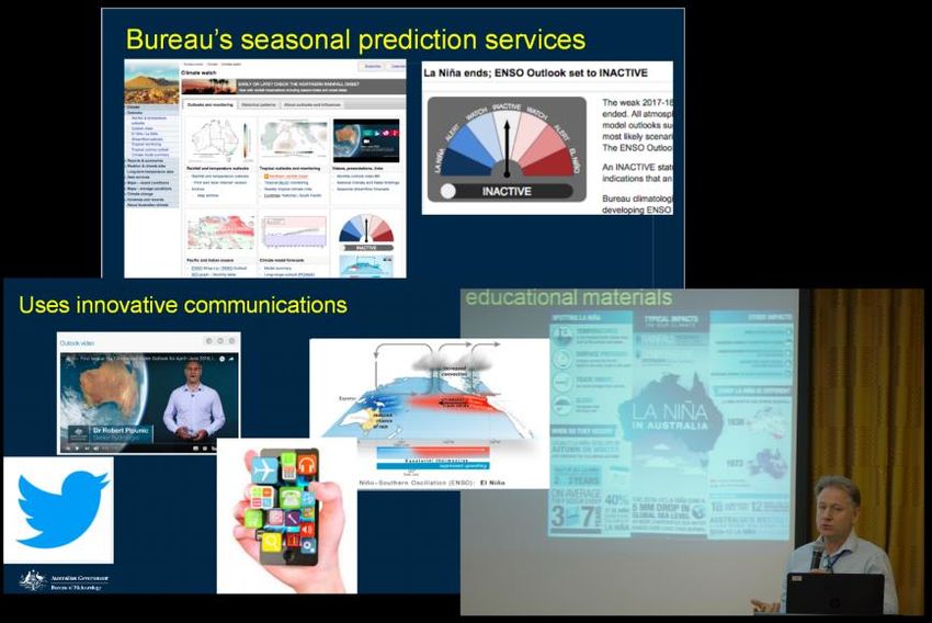
184   decisions has to be made at each step to optimise this process (e.g. appropriate size of model
185   ensemble, impact of model resolution).
186         → It is recommended to review existing methodologies employed across the region to
187         develop technical guidelines in areas such as downscaling, bias-correction, and the
188         spatial and temporal resolution of the data output in light of the intended usage.
189
190   Climate change projections are scenario-dependent. A clear labelling of emission scenarios is
191   necessary: RCP2.6 is the best case aligned with the commitments from the Paris agreement,
192   RCP4.5 is an optimistic scenario, and RCP8.5 is a pessimistic scenario that also at present the
193   business as usual scenario.
194         → It is recommended to continue using multiple scenarios to highlight the benefits of
195         strong mitigation, whilst also acknowledging that more pessimistic scenarios provide
196         stronger (and possibly more likely) climate change signals.
197
198   Very high-resolution models or Convection Permitting Models (CPMs) are recognised as a
199   necessary tool to properly tackle convection, which is the most fundamental rainfall
200   mechanism in the tropical ASEAN region. However, considering their significant computing
201   costs, CPMs come with inherent limits in terms of the range of uncertainties (scenarios, model
202   sensitivity) that can be explored. At this point in time, the added benefit of very-high
203   resolution simulations and the required resolution to properly represent convection is not
204   well-established across the climate of the region.
205           → It is recommended to develop regional technical guidelines on the optimal usage of
206           convection-permitting models to best complement existing climate change
207           information.
208
209   Climate change projections generated from dynamical downscaling (RCMs) methods may be
210   contrasted against projections emanating from statistical downscaling methods (which relies
211   on empirical relationships between large-scale forcing and local scale responses established
212   from observations). Though the motivation for comparison is to increase understanding of the
213   mechanisms at play in a warming world, currently it presents more of an additional challenge
214   than a useful contribution, given a lack of understanding of how to combine information from
215   the two approaches, especially when the projections diverge. However, increasing computing
216   power as well as the recent advances in very-high resolution Convection Permitting Models
217   (CPMs) will provide more opportunities to investigate the reliability of projections from
218   dynamical and statistical downscaling approaches.
219         → It is recommended that appropriate statistical downscaling methods are included in
220         the development of national climate change projections and combined with dynamical
221         approaches to maximise the added value. The optimal integration of these two
222         approaches needs to be addressed in the proposed regional technical guideline.
223
224   Future changes in climate extremes and variability pose significant risks to the region.
225   However, extreme indices commonly used are generic and may not necessarily be well-
226   adapted to the region and the range of users across the VIA community. Developing
227   appropriate extreme indices is a scientific challenge, with users pushing for very high temporal
228   resolution (daily and sub-daily) products. Though these indices can be computed, they may
229   not be scientifically well-grounded.
                                                                                                    5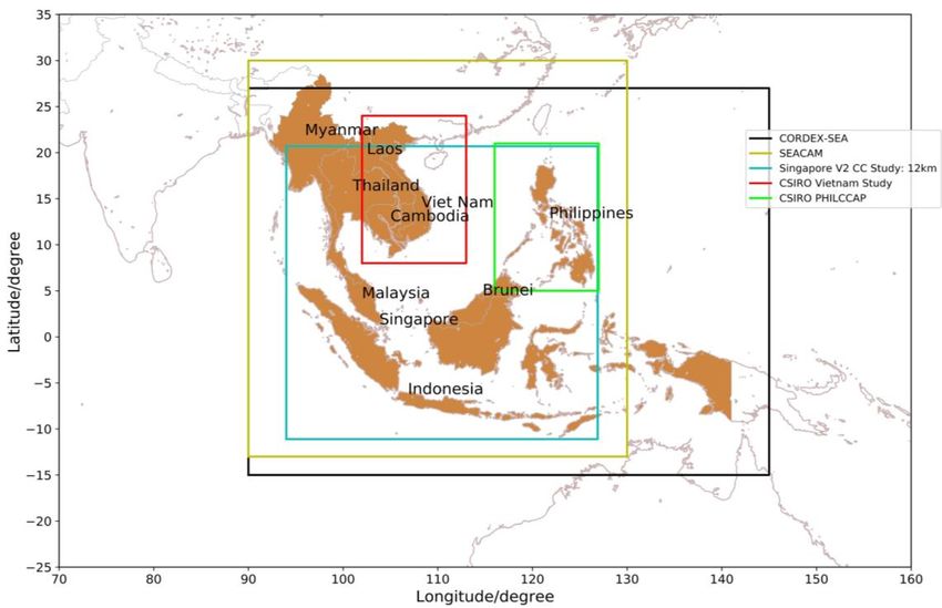
230         → It is recommended that suitable extreme indices of relevance to the users of climate
231         change information across the region are identified as part of the proposed regional
232         technical guidelines.
233
234   Good observational datasets are required not only in the evaluation of RCMs, but also in the
235   development of appropriate bias-correction methods across the full Southeast Asia domain.
236   Hence, current bias-correction methods are mostly performed for small regions with suitable
237   high density observation networks. Several observational products of different origins are
238   available, such as satellite-based estimates and reanalyses.
239         → It is recommended that a regional study be completed evaluating the persistent
240         differences between various gridded datasets available for the region, as well as
241         outlining the steps for the development of a common dataset to standardize model
242         evaluation.
243
244   Sea level rise poses a major challenge for many ASEAN countries, many of which face
245   increased vulnerability as a result of densely-populated coastlines, mega-cities and low-lying
246   agricultural production regions. It is thus important to put in place robust measures that
247   protect coastal areas and minimise the potential for substantial losses from extreme coastal
248   flooding. The science of sea level rise is complex and evolving rapidly; projections from semi-
249   empirical methods may be much higher than the multi-method synthesised projections from
250   previous IPCC reports, thus opening the possibility for higher upper bounds.
251         → It is recommended that national climate change projections encompass the full
252         envelope of risk associated with global sea level rise, including the low-probability, high-
253         impact plausible scenarios emerging from new assessments conducted overseas.
254
255

256   2.2 Delivering Climate Change Information Across Southeast Asia
257   There is now an abundance of climate change information across Southeast Asia; the amount
258   and quality of the products available has grown considerably. This abundance has made it
259   challenging for many ASEAN countries to fully grasp existing data and products, which may in
260   some cases be restricted or difficult to share. Several web-based portals are being developed
261   with a desire to be comprehensive and serve the regional community broadly (e.g. the existing
262   Regional Climate Consortium for Asia and the Pacific (RCCAP) portal, the observation data
263   portal Southeast Asian Climate Assessment & Dataset (SACA&D) and the new CORDEX-SEA
264   related Southeast Asia Regional Climate Change Information System (SARCCIS) portal). All
265   these existing portals are acknowledged as potential solutions, if implemented on a more
266   comprehensive scale.
267         → It is recommended to review the various existing platforms providing climate
268         projection information across Southeast Asia and determine the feasibility of
269         streamlining and/or consolidation.
270
271   A regional consortium for delivering climate projections is a possible approach, as
272   demonstrated by representatives from the Pacific-Australian Climate Change Science
273   Adaptation Planning (PACCSAP) programme from the Southwest Pacific region. This example

                                                                                                      6
274 highlights the need for long-term commitment towards capacity building in order to create a
275 “community of practice.” RCCAP, which was developed under the Asian Development Bank
276 (ADB) and piloted by three ASEAN Member States (Indonesia, Thailand and the Philippines),
277 could serve as a framework to adapt the PACCSAP approach to the ASEAN region, but
278 ultimately it was recognized that to be effective, the consortium should be hosted by an
279 organisation with a regional mandate. The Southeast Asian Regional Climate Change Network
280 (SEA-RCC), with its commitment to supporting regional NMHS in delivering climate
281 information and services, is a natural springboard for the proposed consortium. Sources of
282 funding for such development should be sustainable in the long-term. One possible option is
283 for ASEAN to take the lead, possibly by increasing the role of the existing Asian Specialised
284 Meteorological Centre (ASMC). Other sources of funding, such as the Green Climate Fund, the
285 Asia Pacific Network and the Asian Development Bank, were also proposed. It is also
286 recognised that the dissemination of the climate change information is also a key objective of
287 several transboundary organisations dealing with the VIA community (for example RIMES,
288 which guides sectoral agencies in adaptation planning, and AHA Centre, which maintains
289 platforms to aggregate information about climate-related natural disasters).
290 → Support is recommended for the establishment of a Southeast Asian consortium for
291 climate projections and services, aligned with the existing SEA RCC-Network, as well as
292 the Pacific Islands RCC Network. Ideally, the newly-developed consortium will provide a
293 collaborative platform through which authoritative and centralised information may be
294 delivered to the VIA community.
295
296 2.3 Interacting with Users of Climate Change Information
297 Significant gaps remain between generating climate change projections and using them to
298 make policy decisions. In some instances, there are no climate projections available. In others,
299 projection information may not be useful or appropriate for decision making. There is
300 therefore a need to develop a “science to action” framework in which climate change research
301 is translated into operational resilience and tangible mitigation policies. However, it must also
302 be recognised that many institutions tasked with handling climate data may not be well-
303 equipped to provide climate services and hence it is necessary to build, establish and maintain
304 bridges between the science community and end-users. Early and active end-user
305 engagement to deliver tailored climate services was identified as a key strategy for effective
306 adaptation planning, particularly in fostering a mutual understanding of projection
307 uncertainties. Many Member States have already implemented national platforms for inter-
308 agency dialogue, and due to the varying mandates of the NMHS, a wide spectrum of user
309 engagement and communication strategies exist across the region. However, whilst tailoring
310 climate information to individual stakeholder needs is desirable, it can require considerable
311 time, effort and flexibility that may be beyond the capacity of nationally-mandated bodies.
312 Therefore, there is great value in sharing lessons learnt through stakeholder liaisons.
313 → It is recommended that, as a community expressing willingness to collaborate, we
314 look beyond the exchange of scientific data towards investing in the notion of “sharing
315 of the learning”: case studies, interactions between providers and users...
316
317 Many examples emerged during the workshop on the successful uptake of the climate change
318 information during the development of adaptation policies. Some were based on the
319 provision of necessary high resolution information to address microclimatic effects, while
320 others targeted ‘worst case’ scenarios for risk averse sectors or long timescales required for
7321 decision-making (e.g. the expected lifetime of infrastructure). The most effective cases were
322 able to capture the uncertainties associated with projections, building climate resilience
323 through holistic approaches that were adaptive, flexible, and able to prioritise measures to
324 avoid the pitfalls of over-planning.
325 → It is recommended to document successful applications of the climate change science
326 across the region in a scientific paper with multiple authorship.
327
328 Amongst workshop participants, who were predominantly climate scientists, a consensus
329 emerged that the top-down approach to the application of climate change information is
330 limited at best. “Reverse” modelling approaches, which begin with a consideration of
331 proposed adaptation strategies, were identified as innovative co-production strategies to
332 incorporate climate modelling and planning. Engagement of the general public was also
333 identified as important in developing policy to ensure buy-in from the population, with the
334 government playing the leading role in this interaction.
335 → It is recommended that dedicated liaison officers be identified (e.g. climate
336 champions) that could operate with specific sectors but at a supranational level through
337 the right regional mechanism (e.g. ASEAN secretariat).
338
339
340 2.4 Regional Integration of Climate Change Science and its Application
341 Climate change is a global phenomenon and its impacts are not defined by political
342 boundaries. Understanding climate variability and change in the Southeast Asia as a whole is
343 critical, relevant, and beneficial for the development of national climate change projections
344 in each country. It is clearly beneficial to aim towards a win-win strategy of close collaboration
345 (and data-sharing) among the ASEAN countries when it comes to the development,
346 improvement and application of the climate change science.
347
348 CORDEX-SEA has produced a set of projections, along with scientific analysis and publications,
349 that can be used to support national level climate projections. These projections can also be
350 used to scientifically evaluate methodologies (e.g. bias correction and further downscaling to
351 station-level resolution) in providing information for end-user impact studies. Even in
352 countries where extensive assessments of modelling uncertainties have already been carried
353 out, the CORDEX projections can assess of the robustness of key results. CORDEX-SEA is to be
354 congratulated for the monumental effort in coordinating regional simulations and the
355 achievement of the programme’s mission goals. Nevertheless, more can be done to continue
356 to populate the largest possible matrix of GCMs boundary forcings versus RCMs being used in
357 the regions. Furthermore, as CORDEX-SEA embarks on the next challenge of CPM simulations
358 on suitable smaller domains, the very large associated computing cost makes it even more
359 critical that CORDEX-SEA prosper.
360 → It is recommended that all ASEAN countries note the achievements of CORDEX-SEA
361 and prioritise future climate change science to both contribute and benefit from this
362 initiative, in order to 1) maximise the database and available matrix of GCMs vs. RCM
363 simulations, 2) maximise the learning from existing simulations and 3) support
364 CORDEX-SEA in leading the regional community on the path of using CPMs.
365
8366 Workshop participants recognised the role that the World Meteorological Organisation
367 (WMO) could play in fostering better collaboration across the ASEAN region with regards to
368 the development of national climate change projections. WMO is the reference organisation
369 for NMHSs and the sponsor of the World Climate Research Program (WCRP), under which the
370 global CORDEX program (including CORDEX-SEA) is being coordinated. In addition, WMO has
371 developed a vision toward the provision of climate services for all timescales, including the
372 longer timescales at which climate change is relevant.
373 → It is recommended that the outcomes and recommendations of this workshop, be
374 presented at the upcoming WMO general assembly for Region V as part of a report on
375 the Working Group for Climate Services (WG-CLS).
376
377 The IPCC will deliver its next Assessment Report (AR6) in 2021. It is anticipated that the
378 community of climate scientists across Southeast Asia can make a strong contribution based
379 on the important work which has been completed since the previous AR5.
380 → It is recommended that Southeast Asia climate scientists aim to have their work
381 published in time to be considered for the next IPCC AR6.
382
383 Coordinating efforts across the community will require leadership and funding support. The
384 question of sustainability and funding for such development was raised, with one possible
385 option for ASEAN to play a greater part, possibly by increasing the role of the existing Asian
386 Specialised Meteorological Centre (ASMC), and another option to explore other funding
387 sources (in particular the Green Climate Fund, the Pacific Network and the Asia Development
388 Bank). The proposal to extend the current scope of ASEANCOF to include climate change
389 projections was also strongly supported. An important component of such development
390 would be to build regional capacity and reduce reliance on external expertise.
391 → It is recommended that the community of climate change scientists in Southeast
392 Asia develop projects endorsed by the ASEAN secretariat and WMO, as well as seek
393 support from relevant financial sources.
394
395 Participants also noted that cross-sectorial platforms such as this “Best Practice Workshop”
396 provide valuable opportunities to foster regional communication on issues of climate change.
397 → It is recommended that a follow-on workshop is organised to review progress on
398 the proposed scientific publications (i.e. regional datasets, weather and climate
399 processes, successful applications of climate change information and guidelines to
400 generate national projections), strategies to embed in existing national projections the
401 new set of global climate stimulations (CMIP6) and strategies to tackle new scientific
402 frontiers, in particular the use of CPMs.
403
9404 3 Detailed Meeting Report
405 3.1 Day 1 Presentations: Climate Change Projections from National
406 Meteorological and Hydrological Services (NMHSs)
3.1.1 Summary
Representatives from National Meteorological and Hydrological Services (NMHSs) of 9
ASEAN Member States (Cambodia, Indonesia, Lao PDR, Malaysia, Myanmar, Philippines,
Singapore, Thailand, and Vietnam) presented on the national climate change projection
studies and impact management plans developed by each member state. The diversity of
methodological approaches to producing downscaled climate projections for policy
planning was a reflection of the wide range in technical expertise, capacity and resources,
stakeholder needs, organizational structure, and external collaborations/partnerships
amongst the Member States. In particular, Member States differed in their (i) use of single-
or multi-model ensembles from either CMIP3 or CMIP5; (ii) use of statistically- or
dynamically-downscaled models and bias correction; (iii) projections of future means or
extremes; and (iv) strategies to utilise climate projections for adaptation planning,
including communication of model uncertainties. The participants highlighted the need for
standardization, especially in the selection and evaluation of models (GCMs and RCMs
alike), which in turn would require improved sharing of observation data and model
outputs.
Active end-user engagement to deliver tailored climate services was identified as a key
strategy for effective adaptation planning. These “end-to-end” approaches should build
upon a mutual understanding of model uncertainties, especially in the representation of
natural climate variability and the projection of future extremes. Communication of these
uncertainties was identified as a key challenge in delivering climate projections to end-
users. Although many Member States have already implemented national platforms for
interagency dialogue, there is a great diversity of partnership structures, which may in part
be attributed to the varying mandates of the NMHS, resulting in a wide spectrum of user
engagement and communication strategies across the region. It was therefore recognised
that there is a need to firstly, encourage the building of capacities toward the development
of national approaches to climate change science, and secondly to develop regional
infrastructure to facilitate coordinated climate change research and knowledge sharing.
Representatives from the Pacific-Australian
Climate Change Science Adaptation Planning
(PACCSAP) programme explained the regional
consortium approach to delivering climate
projections across the Southwest Pacific region
and in particular, highlighted the need for long-
term commitment towards capacity building to
create a “community of practice.” The Regional
Consortium for Asia Pacific (RCCAP), which was
developed under the Asian Development Bank
(ADB) and piloted by three ASEAN Member States
(Indonesia, Thailand and the Philippines), could Geoff Gooley, CSIRO, Australia, summaries
key issues from Day 1 of the Workshop
serve as a framework to adapt the PACCSAP
approach to the ASEAN region, but ultimately it was recognized that to be effective, the
consortium should be hosted by an organisation with a regional mandate.
10407 Mr Soim Monichoth, MOWRAM, Cambodia, presented the hydrological modelling of
408 projected changes in water available for irrigation in the Pursat River Basin, Cambodia, using
409 Scenario A1B from the CMIP3 database. The hydrological model (SWAT) was run using
410 statistically downscaled sub-basin scale climate
411 projections derived via SimCLIM climate data
412 analysis tool. Basin flow is predicted to increase
413 under Scenario A1B, with implications for future
414 domestic and commercial water use for irrigation
415 and hydropower. However, in the absence of a full
416 assessment of the uncertainties, it is unknown to
417 what extent these predictions may be dependent
418 on (i) model selection, (ii) emission scenarios and
419 (iii) downscaling methodology. Ms Thelma Cinco,
420 from PAGASA, Philippines, later demonstrated the
421 large difference in projected trends for statistically
422 downscaled versus dynamically downscaled RCM
423 projections for the Philippines, emphasising the
424 need for standardisation and quality control during
425 the evaluation and selection of models for impact
Map of the Pursat River Basin in Cambodia
426 studies.
427
428 Mr Sengduangduan Phouthanoxay, MONRE, Lao PDR, explained to the audience Lao’s
429 national preparedness and disaster management policies, highlighting the importance of
430 inter-agency coordination via “Ministry Focal Points.” It emerged that resource availability
431 and technical expertise remain key challenges for future plans to develop a National
432 Adaptation Plan (NAP) and further national climate change projection research over the
433 period 2013-2020. Lao is faced with challenging meteorological conditions (extreme rainfall
434 during the monsoon season and tropical cyclones) and the priority for the country is to
435 develop a map of risk and vulnerabilities.
436
437 Ms Zin Mie Mie Sein, DMH, Myanmar, focused on the future projections of summer monsoon
438 (MJJASO) rainfall over Myanmar under RCP4.5 and RCP8.5 using a sub-selection of CMIP5
439 models, re-gridded to 50km
440 resolution. 4 GCMs were
441 selected, using a Taylor
442 diagram to compare the
443 suite of 22 CMIP5 model
444 outputs against GPCP
445 historical rainfall (1979 –
446 2005), although it was noted
447 that the ensemble mean
448 gave the best
449 representation in comparison to any individual
450 model. All selected models project an increase
451 in mean MJJASO rainfall during 2019 – 2045 for
452 all regions in Myanmar, with little variation
Ensemble member projections of summer monsoon rainfall
453
changes over Myanmar under RCP8.5 from four selected noted between RCP4.5 and RCP8.5 except in
CMIP5 GCMs 454 the western region of Myanmar. Ms Sein
455 identified future changes in monsoon rainfall
11456 variability as a key research focus moving forward, given Myanmar’s current vulnerability to
457 flooding from extreme rainfall events.
458
459 Ms Ruthaikarn Buaphean, TMD, Thailand, presented the projected changes in temperature
460 and rainfall over Thailand under CMIP3-based scenario A2 (ECHAM4) and A1B (HadCM3) using
461 the PRECIS RCM. Although maximum and minimum temperature projections show a clear
462 increasing trend in both scenarios, the projected changes in average rainfall vary spatially
463 across Thailand, with no clear directional trend apart for the rainy season from mid-May to
464 mid-October, where an increase in the north and a decrease in the south suggest a shift of the
465 mean position of the ITCZ across the country. Ms Buaphean also highlighted the mismatch
466 between the model output and historical observation data, and therefore outlined plans to
467 include bias correction in future studies. However, as is also the case for Ms Zin’s study, these
468 downscaled climate projections have yet to be incorporated into national impact-based
469 adaptation studies. Ms Buaphean mentioned a collaboration between Thailand and Japan to
470 generate CMIP5-based downscaled climate change projections.
471
472 Mr Nguyen Dang Quang, NHMS, Vietnam, presented the national climate change and sea
473 level rise projections for Vietnam, an exercise Vietnam is committed to update every 5 years.
474 The projections presented are comprehensive, being based on dynamical downscaling, using
475 5 RCMs (AGCM/MRI, PRECIS, CCAM, RegCM, WRF) with bias correction from 16 CMIP5 GCMs
476 under RCP4.5 and RCP8.5 scenarios. Models project an increase in mean temperatures over
477 the whole country, and greater spatial variability for rainfall due to changes in the monsoon
478 regime: i.e. an increase of
479 rainfall between 10 and
480 20% in the south and a
481 decrease between 5 and
482 15% in the north. Sea level
483 rise projections were
484 based on the AR5 set of
485 models and used similar
486 analysis from previous
487 studies in Australia,
488 Holland and Singapore to
489 assess the mean sea level
490 rise by 2100 under RCP4.5
Sea level rise potential inundation maps developed by the Vietnam National
Hydro-Meteorological Agency. Separate high resolution inundation risk491
maps and RCP8.5. High-
for Ho Chi Minh city and Mekong River Delta are also available.492 resolution potential
493 inundation risk maps from
494 1m sea level rise (total sum of projected mean sea level rise and maximum tide) have been
495 developed for deltaic and coastal regions and islands. These maps indicate a potentially very
496 high impact, even without accounting for potential inundation risks from storm surges (e.g.
497 across the Mekong delta up to 40% of the land is at risk of flooding under a 1m sea level rise).
498 Mr Nguyen notes that although workshops have been organised to communicate projection
499 results and uncertainties to different stakeholders, currently the Vietnam Hydrological
500 Meteorological Agency has limited ability to provide specialised climate services to end-users.
501 Mr Nguyen also stressed the need to develop guidelines for bias correction, starting with a
502 systematic analysis of current methodologies in particular to increase the credibility of the
503 projections for users.
12504 Ms Apriliana Rizqi Fauziyah, BMKG, Indonesia, presented both statically and dynamically
505 downscaled climate projections for Indonesia under RCP4.5 and RCP8.5 scenarios. Statistical
506 downscaling of 6 CMIP5 GCMs (CanESM2, MIROC-ESM, MPI-ESM MR, CNRM-CMS, GDFL-ESM,
507 HADGEM2-ESM) was completed using two methods (an analogue approach and generalised
508 linear model approach) for daily extreme temperature and rainfall and validated against
509 observational (1980 – 2010) and reanalysis data (1971 – 2000). In the meantime, medium-
510 resolution (20km) and high resolution (5km) dynamically downscaled projections were
511 produced with the WRF RCM (driven by the MIROC5 GCM). Plans are in place to deliver these
512 high-resolution climate projection as part of
513 an “atlas of maps” for every major
514 Indonesian island in order to facilitate
515 national adaptation planning. Workshop
516 participants noted the use of the terms
517 “optimistic” and “pessimistic” by BMKG in
518 reference to RCP4.5 and RCP8.5 as an
519 effective method to communicate emission
520 scenarios to end-users. The selection of a
521 single RCM was due in part to previous
522 collaborative linkage, and it was recognised
523 that whilst the project was the first step
524 towards capacity development, future work Indonesia archipelago climate projection map (centre)
525 should look into exploring the performance with a selection of medium resolution maps for specific
islands as produced by BMKG
526 of a wider ensemble of RCMs.
527
528 Mr Muhammad Firdaus Ammar bin Abdullah, MMD, Malaysia choose a different perspective
529 compared to many presentations and discussed in relation to climate change projections, the
530 operational challenges faced by the Malaysian Meteorological Service (MMD), highlighting
531 the need to improve observational networks to facilitate model validation and understanding
532 of mechanisms driving climate variability. Mr Muhammad stressed the importance of a
533 “science to action” framework, in which climate change research is translated into operational
534 resilience in contrast to a purely academic climate change science aimed at scientific
535 publication. To this end, Mr Abdalah Mokssit, IPCC secretary, called for greater inter-agency
536 dialogue between NMHSs, producers of climate change projections and relevant government
537 stakeholders at a national level first to support international collaboration (i.e. across south-
538 east Asia) second.
539
540 Ms Thelma Cinco, PAGASA, Philippines, presented the provision of climate projections for the
541 Philippines using the RCP4.5 and RCP8.5 scenarios. Three RCMs (PRECIS, CCAM and RegCM4)
542 were dynamically downscaled to 25km resolution and the HadGEM3 RCM was downscaled to
543 12km resolution. The RCMs were driven by 8 GCMs (HadGEM2-ES, ACCESS1.0, CNRM-CM5,
544 CCSM4, GDFL-CM3, MPI-ESM-LR, NorESM1-M, MRI-CGCM3)
545 yielding a 7-model ensemble for RCP4.5 and a 12-model
546 ensemble for RCP8.5. RCM performances were evaluated
547 against observed climatology (APHRODITE gridded dataset)
548 using Taylor diagrams, and showed good clustering for the
549 temperature variable but relatively lower correlation for
550 rainfall. In addition to dynamical downscaling, statistical
551
Ms Thelma Cinco presenting downscaling was used to project mid-century annual mean
552
Philippines’ PAGASA experience temperature change and rainfall change under RCP8.5. The
13553 statistically downscaled projections
554 were shown to vary greatly from the
555 relatively clustered RCM ensemble
556 member projections. Ms Cinco
557 postulated that this might be due to
558 the use of absolute humidity at 850
559 hPa (a quantity which is expected to
560 rise with global warming), in the
561 statistical model. Furthermore, Ms
562 Cinco highlighted the value of
563 comparing model performance not
564
Comparison of dynamical (circles) and statistical (red triangles) only amongst ensemble members,
565
downscaled century projections for temperature and rainfall but also across model generations
change for mid-century under RCP8.5 for the Philippines 566 (CMIP3 vs. CMIP5). PAGASA has
567 published a synthesis report for policy makers on observed historical trends and climate
568 projections for the mid- and end-century. The report outlines ensemble projections of not
569 only mean annual temperature/rainfall change, but also changes in extreme seasonal rainfall
570 (defined as the 90th and 10th percentile rainfall) and tropical cyclone frequency/intensity. To
571 communicate impacts of climate projections to end-users, Ms Cinco demonstrated the use of
572 the Climate Risk Analysis Matrix (CLIRAM), which informs on the risk, potential impact, and
573 adaptation strategies for projected climate changes under each emission scenario, as applied
574 to the agricultural sector in Salcedo. Furthermore, PAGASA is engaged in supporting the Local
575 Climate Change Adaptation Plan (LCCAP) by providing climate projections to local
576 governments. Workshops (e.g. “Training of Trainer”) are also conducted to enhance
577 information sharing to end-users. Ms Cinco noted that policy makers require climate
578 projections to be translated into impacts, which often involve estimates of return periods or
579 probabilities. It is therefore crucial that model uncertainties are effectively communicated to
580 end-users.
581
582 Mr Chris Gordon, Senior Advisor of CCRS, Singapore, presented the 2nd National Climate
583 Change Study for Singapore, conducted jointly
584 by the Centre for Climate Research Singapore
585 (CCRS) and the UK Meteorological Office
586 (UKMO) Hadley Centre. Mr Gordon
587 emphasised end-to-end stakeholder
588 engagement as a contributor to the successful
589 integration of the study results into national
590 impact assessment and adaptation strategies,
591 implemented under the inter-agency
592 Resilience Working Group (RWG). Preliminary
593 engagement allowed scientists to anticipate
594 projection requirements of downstream
595 impact modellers and suggest alternatives
596 when requirements could not be supported on
597 a sound scientific basis. Dynamically
598 downscaled projections for RCP4.5 and RCP8.5
599 were generated using the PRECIS RCM at 12km
600 resolution driven by a sub-selection of 9 CMIP5
601 GCMs. Bias correction was applied to the end Overview of the various stages involved in the
602 products and found to be essential for impact completion of Singapore’s 2nd National Climate Study
14603 modelling, though this was only done for the Singapore output as a similar work across the
604 full domain would be difficult due to uncertainties in the observations. Multiple model sub-
605 selection criteria were used to judge the skill of the GCMs, including representation of
606 monsoon flow, Pacific Ocean and El Nino Southern Oscillation (ENSO) teleconnections. Models
607 were also strategically chosen to span the range of climate sensitivities. Downscaled
608 simulations were shown to improve representation of the annual precipitation cycle over
609 equatorial Southeast Asia compared to the host GCM. The study was documented by a
610 synthesised report of ensemble climate projections, aimed at stakeholders and policy makers,
611 as well as a series of technical reports focusing on various aspects of the generation of the
612 results. Mr Gordon identified the modelling of extreme rainfall, treatment of the urban
613 landscape, representation of natural decadal climate variability (and its interpretation by
614 stakeholders) and understanding of the contribution to sea level rise by various components
615 as key challenges for Singapore moving forward. He also pointed that the synthesis of model
616 projections was critical in more effectively communicating uncertainties associated with
617 climate projections.
618
619 Mr Geoff Gooley, CSIRO, Australia, Mr Scott Power, BoM, Australia and Mr Salesa Nihmei,
620 SPREP, Samoa, presented on the experience of the Pacific-Australian Climate Change Science
621 Adaptation Planning (PACCSAP) programme in delivering climate projections to the Western
622 Tropical Pacific Ocean, an ambitious task considering the region is 10 times the size of Europe
623 and made of small islands of comparable size to Singapore. Given the isolation of Pacific Island
624 Member States and their diversity of technical capacities, it was recognised that a regional
PACCSAP Climate Futures Portal delivers climate change projection information across the Southwest Pacific
625 approach was necessary to effectively produce and communicate climate projections to the
626 public. Regional coordination was facilitated through SPREP, a 25-year old institution and the
627 leading inter-governmental organization on climate change and environmental monitoring in
628 the Pacific region. The science component of the PACCSAP programme was committed to
629 improving understanding of climate change science in the region. In addition to conducting
630 research into climate projections, a number of data analysis tools were created to enhance
631 technical support and the dissemination of information. These include the Pacific Climate
632 Futures V2.0 portal, which gives users access to downscaled CMIP5 data, and the Climate Data
633 for the Environment (CLiDE), a tool now used operationally for data storage and management.
634 Some creative initiatives to educate the public on key climate components, such as ENSO,
635 were developed (e.g. the “Climate Crabs” animation video). These videos, which are available
636 online and have been translated in 6 local languages, helped raise awareness across all levels
15637 on climate change, and were complementary to the numerous training workshops and
638 collaborations organised for capacity development in the region. In order to enhance sectorial
639 engagement, PACSAPP generated tailored climate projection reports for each participating
640 Pacific Island country. The Regional Summary of New Science and Management Tools, a
641 comprehensive report on the methodology of generating projections specifically targeted at
642 non-technical stakeholders, as well as Fact Sheets on key climate issues, were also identified
643 as successful information sharing initiatives. Mr Salesa noted that although the PACCSAP
644 programme has concluded, it is crucial to sustain links and partnerships developed through
645 the programme.
646 In adapting the PACCSAP model to the ASEAN region, the RCCAP pilot study was identified as
647 a possible starting point. At present, RCCAP is in its infancy for the ASEAN community since
648 only 3 Member States (Indonesia, Philippines, and Thailand) are included. Nevertheless, it
649 presents a real opportunity going forward as this tool could easily be developed further for
650 the full ASEAN community, provided a “champion” could be identified within the region to
651 lead the initiative.
652 Mr Gooley noted that if this tool were to be adopted by the full ASEAN community, it would
653 form a natural bridge between the Southwest Pacific and Southeast Asia communities as the
654 portal development will continue under Australia leadership (CSIRO and BoM) for the
655 Southwest Pacific region.
Workshop participants exchanging experiences during the break on the first day of the workshop
656
16657 3.2 Day 2 Presentations: Scientific Achievements and Challenges in
658 Delivering Regional Climate Projections
3.2.1 Summary
International experts from UKMO, CSIRO, and BoM, along with regional experts from the
CORDEX-SEA community, and from Singapore institutions (CCRS, TMSI, EOS) provided an
overview of the key challenges in delivering downscaled regional climate projections for
the ASEAN region. Climate projections are now available from a variety of RCM simulations
performed by NMHSs in collaboration with international organisations (such as the UKMO
and CSIRO) and also through regional collaborative initiatives such as CORDEX-SEA. Both
have encouraged local capacity building across many member states. This now presents a
new challenge on how best to coordinate, combine and synthesise data from multiple
sources and methodologies, and deliver consistent climate information to national
stakeholders.
Southeast Asia is a region with high climate risk, but low adaptive capacity. Infrastructural
vulnerability to extreme events (such as floods and droughts, tropical cyclones and
typhoons) is often the immediate priority for policy makers. There is a need to first adapt
to naturally occurring climate variability before attempting to assess and defend against
changes in climate risks from anthropogenic climate change. Hence, understanding how
drivers of natural climate variability, such as the El Nino Southern Oscillation (ENSO), will
respond to future climate change remains a key area of research interest. Besides changes
in climate variability, reliable estimates of long-term mean climate changes, such as sea
level rise, are integral for the sustainable development of the region. Very high-resolution
convection-permitting simulations are also starting to show real success in improving
model representation of extreme rainfall. These high-resolution models have also been
used to estimate future risks from extreme sea level change due to storm surges.
Participants called for the development of standardised procedures for model selection
and intercomparison, regional process studies, assessment of natural variability, the
treatment of model biases and errors, and RCM domain selection criteria. Discussions drew
upon examples of good practices exhibited by a number of ASEAN NMHSs in their
production of national climate projections and also highlighted the need for enhanced data
sharing within the region. Such development would improve the understanding of the
uncertainties surrounding national climate projections, which are always incomplete. In
addition, active stakeholder engagement during the production of climate projections
could aid in educating users on the uncertainties associated with climate projections.
However, it was recognised that this requires strong and sustained collaborative links,
considerable time, effort, and flexibility that may be beyond the capacity of nationally
mandated bodies. Therefore, there is great value in sharing lessons learnt through
stakeholder liaison across Member States.
However, given the absence of a strong regional platform for collaboration on climate
change projection research, substantial cross-institutional collaboration of this nature
remains currently immature. On the issue of data collection, storage and sharing, portals
such as the SEA Regional Climate Change Information System (SARCCIS), the Southeast
Asian Climate Assessment Dataset (SACA&D) and the Regional Consortium for the Asia
Pacific (RCCAP) were acknowledged as potential solutions, if implemented on a more
comprehensive scale. Moving forward, participants called for a regional framework for
communication and collaboration between Member States, in hopes of consolidating the
diversity of research currently being conducted across the region.
17You can also read