Cell Mergers and their Impact on Cloud-to-Ground Lightning over the Houston Area
←
→
Page content transcription
If your browser does not render page correctly, please read the page content below
https://ntrs.nasa.gov/search.jsp?R=20110014597 2018-10-21T08:17:12+00:00Z

                                                                                                                   1

                  Cell Mergers and their Impact on
                 Cloud-to-Ground Lightning over the
                           Houston Area

                                      Michael L. Gauthier
                                United States Air Force Academy
                                     Department of Physics
                                 2304 Fairchild Hall, Suite 2A45
                                USAF Academy, Colorado 80840

                                     Walter A. Petersen
                              NASA Marshall Space Flight Center
                              NSSTC/Earth Sciences Office VP-61
                                    320 Sparkman Drive
                                 Huntsville, Alabama 35805

                                                      and

                                     Lawrence D. Carey
                                Earth System Science Center
                       National Space Science and Technology Center
                            University of Alabama in Huntsville
                                    320 Sparkman Drive
                                 Huntsville, Alabama 35805

                                          DRAFT 1/30/2009

Corresponding author address: Lt Col Michael L. Gauthier, Department of Physics, 2304 Fairchild Hall, Suite
2A45, United States Air Force Academy, USAFA, CO 80840
E-mail: Michael.Gauthier@USAFA.edu
Voice: (719)333-2370
Fax:    (719)333-3182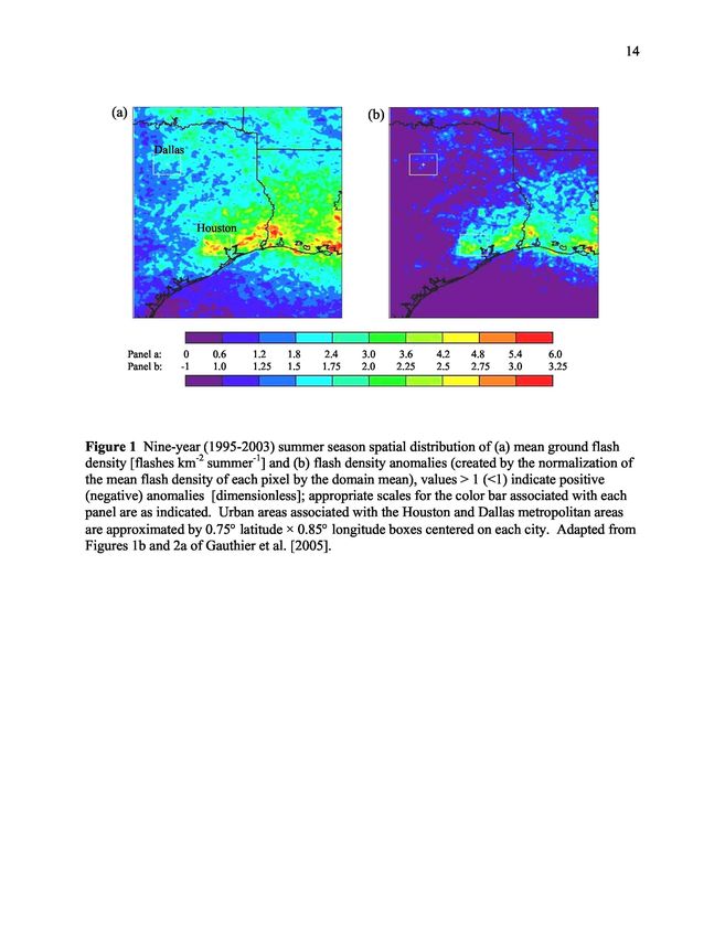
2

                                           ABSTRACT

     A previous hypothesis advanced from observational studies such as METROMEX suggests

that the intensity, frequency, and organization of cumulus convection may be impacted by the

forcing of enhanced merger activity downstream of urban zones. A resulting corollary is that

cities may exert an indirect anthropogenic “forcing” of parameters related to convection and

associated phenomena such as lightning and precipitation. This paper investigates the urban

merger hypothesis by examining the role of convective cell mergers on the existence and

persistence of the Houston lightning “anomaly”, a local maximum in cloud-to-ground (CG)

lightning activity documented to exist over and east of Houston.

     Using eight summer seasons of peak columnar radar reflectivity, CG lightning data and a

cell-tracking algorithm, a two-dimensional cell merger climatology is created for portions of

eastern Texas and Louisiana. Results from the tracking and analysis of over 3.8 million cells

indicate that merger-driven enhancements in convection induce a positive response (O 46%) in

ground-flash densities throughout the domain, with areas of enhanced lightning typically being

co-located with areas of enhanced merger activity. However, while mergers over the Houston

area (relative to elsewhere in the domain) do result in more vigorous convective cells that

produce larger CG flash densities, we find that CG lightning contributions due to mergers are

distributed similarly throughout the domain. Hence while we demonstrate that cell mergers do

greatly impact the production of lightning, the urban cell merger hypothesis does not uniquely

explain the presence of a local lightning maximum near and downstream of Houston.

KEY WORDS: Lightning, Radar, Cell Merger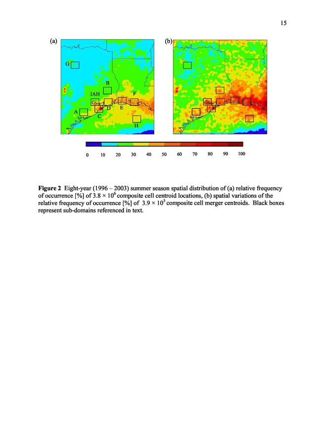
3

1. Introduction

     Anthropogenic influences such as the urban heat island [UHI; see Arnfield (2003) for

extensive discussion] and increased aerosol concentrations have been postulated for many years

to have an effect on lower tropospheric chemistry, convection, lightning and rainfall (e.g., Huff

and Changnon, 1973; Westcott, 1995; Jauregui and Romales, 1996; Rosenfeld and Lensky, 1998;

Bornstein and Lin, 2000; Shepherd et al., 2002; Rosenfeld and Woodley, 2003). Moreover, these

influences have been invoked as possible explanations for cloud-to-ground (CG) lightning

anomalies observed over metropolitan areas such as Houston, Texas. In particular, Orville et al.

(2001) and Steiger et al. (2002) reported a 45% increase in annual CG lightning flash densities

over and downwind of the Houston urban corridor relative to rural surroundings citing

anthropogenic influences as possible causative mechanisms.

      One alternate hypothesis advanced as result of radar studies of convection during

METROMEX (Metropolitan Meteorological Experiment; Changnon et al., 1971) that has been

relatively unexplored as it pertains to the Houston lightning “anomaly” concerns the influence of

the urban environment on convective frequency and upscale (i.e., mesoscale) organization. The

suggestion here is that cities may exert an indirect anthropogenic “forcing” of parameters that are

either directly or indirectly related to cumulus convection and associated phenomena such as

lightning and precipitation. Specifically, results from this early-1970s campaign suggest that

convective intensity may be impacted by urban forcing of enhanced merger activity downstream

of urban corridors (Changnon et al., 1976). Through the development of coincident

climatologies of radar derived cell merger occurrence and CG lightning, this paper investigates

the urban-merger hypothesis by examining the spatial distribution and role of convective cell

mergers on the existence and persistence of the Houston lightning “anomaly”.
4
Theoretically, it is conceivable to extend the METROMEX observations of enhanced storm
mergers downwind of the St. Louis urban area as a plausible explanation for the enhanced
lightning ground flash densities that were found in the same location, as noted by Westcott
(1995). In general, merged systems yield more than an order of magnitude more precipitation
than their unmerged counterparts (Simpson and Woodley, 1971; Simpson et al., 1980), and are
also more vertically developed and intense than those that are not (Houze and Cheng, 1977;
Westcott, 1984). From a thunderstorm electrification stand-point, one would also expect the
merger-induced enhancements in convective vigor to be accompanied by enhanced
concentrations precipitation sized ice, collocated with super-cooled liquid water leading to
enhanced thunderstorm electrification and lightning (c.f., Carey and Rutledge, 2000; Petersen et
al., 2005; Gauthier et al., 2006).
Observationally, the impact of cell mergers on upscale growth and lightning production
was presented for deep island convection occurring just off tropical northern Australia (i.e., Tiwi
island thunderstorms) by Carey and Rutledge (2000), who noted that once cold-pool outflow
boundaries over the Tiwi Islands associated with precipitating convective cells began to interact
with the sea breeze front, the previously isolated cells began to merge, resulting in vigorous
upscale growth, accompanied by significant production of mixed phase ice mass, significant
electric fields, and lightning.
Relative to the Houston metropolis, the UHI along with other mesoscale boundaries (e.g.,
the sea breeze) provide mechanisms to trigger and release instability in the air passing overhead.
The UHI and sea breeze induced convergence boundaries can then interact favorably with cold
pool boundaries generated by the downdrafts of dissipating convection to trigger new convective
cells, which can then merge with older cells, resulting in upscale development. With regards to5
the multitude of hypotheses offered to explain the presence of the Houston lightning anomaly,
the words of the medieval English philosopher and Franciscan monk William of Ockham [ca.
1285-1349], "Pluralitas non est ponenda sine neccesitate" or "plurality should not be posited
without necessity", may prove to be quite applicable. Specifically, when faced with several
possibilities what is the simplest or most obvious explanation for the facts? Given the
complexities of the problem at hand, it seems equally plausible that a “first order” explanation
involves some combination of UHI convergence and thermodynamics, perhaps interacting with
the sea breeze front, resulting in enhanced and/or more frequent convective initiation, and likely
merging, of convective cells over and downwind of Houston.
2. Data and method
The analyses conducted in this study rely on a fused dataset spanning eight summer
seasons (JJA, 1996 – 2003) to develop a regional, two-dimensional (2D) cell merger climatology
for portions of eastern Texas and Louisiana (see Figure 1). Having a horizontal resolution of 2
km × 2 km, the 2D composite radar reflectivity data derived from the National Weather Service
(NWS) Weather Surveillance Radar –1988 Doppler (WSR-88D) network is digitized every 15
minutes with peak columnar reflectivity values available for each grid point. Used as a primary
input into a cell tracking algorithm (described below), composite reflectivity data (comprised of
16 levels of reflectivity beginning at level-0 [0 – 5 dBZ] with increments every 5 dBz) was
coupled with corresponding CG lightning data. Here, ground strikes detected by the National
Lightning Detection Network (NLDN; Cummins et al., 1998) were gridded to match the
horizontal dimensions of the Cartesian composite reflectivity grid for each of 80 000+ time steps
(15-minute temporal resolution). Consistent with previous lightning studies over the same6
domain (i.e., Gauthier et al., 2005; Gauthier et al., 2006), we have chosen to disregard flashes
with positive peak currents less than 10 kA following the recommendations of Cummins et al.
(1998) and Wacker and Orville (1999a,b). The fused composite reflectivity and CG lightning
datasets were used as input parameters to a variant of the Thunderstorm Identification, Tracking,
Analysis and Nowcasting (TITAN) software (Dixon and Wiener, 1993) where individual cells
were identified and tracked throughout the domain over the entire period of record (POR;
JJA, 1996 – 2003).
Before further discussion of the methodology employed within the cell-tracking
algorithm, it is prudent to first define the fundamental building block of a merger – the
convective cell (or “composite cell” in this case). For the purposes of this climatological study, a
convective cell was defined as a contiguous region of composite reflectivity with values greater
than or equal to 30 – 34 dBZ (Zthresh = level-6) with minimum and maximum areas of 8 km 2 (2
pixels) and 5,988 km2 (1,497 pixels), respectively. Although somewhat arbitrary, these spatial
constraints were determined via experimental and statistical means. To investigate the
sensitivity of the cell-tracking algorithm to the composite reflectivity threshold (Zthresh) was set to
levels-5, 6, and 7 (25-29, 30-34 and 35-39 dBZ, respectively). For all three cases the
identification and tracking technique worked well. The level-7 storms were smaller and more
intense (on average) than the level-5 and level-6 storm echo areas; the lower the threshold, the
greater the number of apparent mergers. Conversely, increasing Zthresh resulted in a greater
number of tracked cells. Based on the results of sensitivity testing, Zthresh was set to level-6 (30-
35 dBZ) for the final development of the cell-merger climatology, a reasonable threshold for the
partitioning of convective activity (Dixon and Wiener, 1993; Demott and Rutledge, 1998). The
use of spatial thresholds was necessary to eliminate ground clutter at the individual radar7
locations (lower threshold) as well as to minimize the impact of geo-location errors (discussed
below) associated with larger tracked composite cells (upper threshold). Specifically, an
examination of the merged cell area statistics revealed a positively skewed, non-Gaussian
distribution with an upper-outer fence (defined as Q 3 + 3IQR, where IQR is the inter-quartile
range and Q3 represents the 75 th percentile of the cumulative distribution function [CDF]
associated with cell areas) of 5988 km2. As the upper-outer fence of the data distribution
typically represents the upper threshold of the usable dataset, with values in excess deemed
extreme outliers (Wilkes, 1995), the maximum area threshold was set to equal this value.
Using geometric logic regarding “composite cell” positions and shapes, the cell-tracking
algorithm first identified cells that occurred within the domain. The algorithm then tracked
identified cells, and determined if and when mergers occurred. Tracking was accomplished by
matching cells at some time (t 1 ) with their corresponding counterparts in a subsequent time frame
(t2). Done successively, the cells were able to be tracked for their entire duration. Mergers were
identified to have occurred when the region between two or more separated cells at t 1 exceeded
Zthresh at t2 (i.e., the best-fit ellipses overlapped), at which point a new best-fit ellipse was created
with the cell properties described in Table 1 being geo-located with the centroid of the new
merger ellipse. This means that, in the case of flash counts, all flashes associated with the pixels
comprising the merged cell (i.e., flashes occurring + 7.5 minutes of the valid time that were
located within a pixel whose value is > Z thresh) were geo-located with the merger centroid, hence
losing their spatial identity, relative to this location.
Spatial distributions of cell properties described in Table 1 (both individual and only
those identified as merged cells) were then generated and examined in an effort to determine the
statistical differences between the location, timing, and properties of merged and individual cells.3. Results and discussion
Application of the cell-tracking algorithm to the 80 000+ time-steps contained within the
fused composite reflectivity – lightning dataset resulted in the tracking and analysis of 3.8
million individual cells, 627 569 of which were classified as parents to 190 477 merged cells
(summary statistics are presented in Table 2). We begin our discussion with an examination of
the spatial distributions of cell and cell merger occurrences throughout the domain. Spatially,
there appears to be excellent agreement between the results of the independent analysis of CG
lightning data performed by Gauthier et al. (2005), and the geo-location of cell and cell merger
centroids (compare Figure 1 and Figures 2a and 2b). That is to say that convective cells tend to
occur more frequently along the coast, with increasing frequency from west to east (Figure 2a).
Regarding cell mergers, there appears to be a preferred location of cell merger occurrence
coinciding with the climatological enhancements in CG lightning activity throughout the domain
(compare Figures 2b and 1 a). Additionally, enhanced flash counts gathered through the tracking
of all 3.8 million cells appear to be consistent with the flash density patterns identified by
Gauthier et al. (2005). Here, flash counts associated with each cell occurring within a given
pixel were used to construct the spatial distribution of “tracker produced” mean summer flash
densities (Figure 3a), scaled to match the independent lightning analysis conducted by Gauthier
et al. (Figure 1 a). Given the slight mismatch in PORs between the lightning climatology
presented by Gauthier et al. (2005; 1995 – 2003) and the analysis conducted herein (1996 –
2003, with intermittent gaps) and the limitations inherent within the cell-tracking algorithm and
its associated geo-location assumptions (recall that all CGs coming to ground within the confines
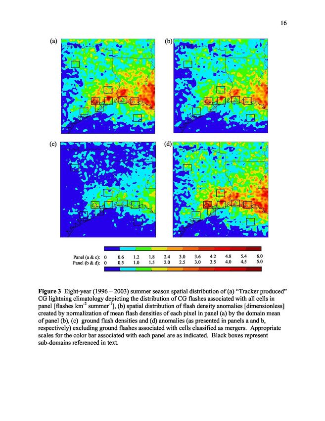
of Zthresh were geo-located with the cell centroid and associated with a single pixel), the9 qualitative agreement between the observed (Figure 1a) and the tracker produced (Figure 3a) lightning climatologies is remarkable, providing a strong indicator that the cell tracking algorithm is functioning as designed. Given the fidelity of the tracker-produced climatology, we then created a flash density “anomaly” map (Figure 3b), as in Gauthier et al., (see Figure 1b), by normalizing the mean flash density of each pixel (xˆ) by the mean flash density of the entire domain (x; i.e., xˆ / x); values >1 (
10

another major urban area within the domain that exits in a different meteorological regime, while

the box located over the open Gulf waters (box H) contains a relative enhancement in merger

activity (relative to other open water portions within the domain). Application of a

nonparametric one-sided Wilcoxon Rank-Sum test for statistical significance reveals that relative

to the Houston area (IAH box), cell mergers elsewhere in Texas (i.e., analysis boxes A, B, C, D,

and G) have statistically larger areas (on the order of 10%; at p-values < 0.05), while those in

analysis boxes E, F and H were found to be statistically similar (summarized in Table 2).

Additionally, with the exception of analysis boxes B (located to the northeast of Houston) and F

(located along the central Louisiana Coast), cell mergers elsewhere produce, on average, 50%

less lightning than mergers occurring over the Houston area. When comparing the mean flash

densities of mergers occurring over the Houston area to those occurring elsewhere within the

domain, we find the mean Houston cell merger to have flash densities nearly double the mean

flash density per merger elsewhere, all statistically significant (p < 0.05; see last column in Table

2).

        As previously mentioned, the degree of similarity between the observed and tracker-

produced CG lightning climatologies provides a considerable degree of confidence in the

performance of the cell-tracking algorithm. The total number of ground flashes contained within

a given pixel (i.e., total flash count, FCtot) throughout the domain is equal to the sum of ground

flashes associated with isolated convective cells (FC i ), parent cells (FC p ) and merged cells (FCm)

such that FC tot = FC i + FC p + FC m . Since the lightning contribution due to mergers at each pixel

is known, it can be subtracted from FCtot to determine if the flash density anomaly persists absent

the influence of mergers. Figure 3c presents the spatial distribution of tracker-produced mean

summer flash densities devoid of ground flashes associated with cells classified as mergers.
11
Note the significant decrease in mean flash densities throughout the domain (on the order of
46%, domain-wide; Table 3). Despite the significant impact on the magnitude of flash densities,
relative enhancements in flash densities remain apparent throughout the domain, particularly
over the Houston area. To further investigate the impact of the exclusion of ground strikes
associated with cell mergers on the lightning anomaly, a flash density anomaly map (similar to
Figure 3b) was created for the “merger removed” lightning climatology, the result of which
(Figure 3d) yields a very interesting result. Despite the significant decrease in the magnitude of
pixel mean flash densities associated with the removal of the lightning strikes attributed to
mergers, we find little change in the spatial distribution of flash density anomalies (compare
Figure 3b [with mergers] to Figure 3d [mergers removed]), thus indicating that mergers
contribute roughly the same percentage of the total lightning “signal”, regardless of geographic
location (see second column in Table 3). In fact, the mean flash density anomaly over the
Houston area (i.e., the IAH box) actually increased from 2.64 to 2.84 times the domain mean
when merger related ground strikes were excluded (Table 3). These findings have significant
implications pertaining to the applicability of the cell-merger hypothesis under investigation;
clearly cell-mergers are not the predominant causative mechanism behind the Houston CG
lightning anomaly.
4. Conclusions
Using eight summer seasons (JJA, 1996 – 2003) of peak columnar radar reflectivity and
associated CG lightning data coupled with cell tracking software, a two-dimensional cell merger
climatology was created for portions of eastern Texas and Louisiana. Through the tracking and
analysis of over 3.8 million “composite” cells, the impact of convective cell mergers on the12 Houston CG lightning anomaly was investigated. Results quantify the general importance of cell-mergers on the upscale growth of convection. Not unexpectedly, we find that merger-driven enhancements in convection induce a positive response (O 46%) in ground flash densities throughout the domain, with areas of enhanced ground flash densities typically being co-located with areas of enhanced merger activity. However, while mergers over the Houston area (relative to elsewhere in the domain) do result in more vigorous convective cells that produce more lightning with larger flash densities, findings suggest that CG lightning contributions due to mergers are distributed similarly throughout the domain. Hence while we have demonstrated that cell mergers do greatly impact the production of lightning, the urban cell merger hypothesis does not explain, exclusively, the presence of a local lightning anomaly near and downstream of Houston (or elsewhere in the domain).
13

Acknowledgments.

This research was supported by funding from the U.S. Air Force Academy through the Air Force

Institute of Technology (MLG), NASA’s Earth Sciences Program (WAP), and NSF grant ATM-

0442011 (LDC). The views expressed in this paper are those of the authors and do not reflect the

official policy or position of the U.S. Air Force, Department of Defense, or the U.S.

Government.
14

    (a)                                               (b)

          Panel a:    0   0.6   1.2    1.8   2.4     3.0     3.6   4.2   4.8    5.4   6.0
          Panel b:   -1   1.0   1.25   1.5   1.7 5   2.0    2.25   2.5   2.75   3.0   3.25

Figure 1 Nine-year (1995-2003) summer season spatial distribution of (a) mean ground flash
density [flashes km -2 summer -1 ] and (b) flash density anomalies (created by the normalization of
the mean flash density of each pixel by the domain mean), values > 1 (
15
(a) —___'- (b)
D E
A
C
H
OR OL
J
0 10 20 30 40 50 60 70 80 90 100
Figure 2 Eight-year (1996 – 2003) summer season spatial distribution of (a) relative frequency
of occurrence [%] of 3.8 × 10⁶ composite cell centroid locations, (b) spatial variations of the
relative frequency of occurrence [%] of 3.9 × 10 5 composite cell merger centroids. Black boxes
represent sub-domains referenced in text.16
(a) (b)
(c) (d)
Panel (a & c): 0 0.6 1.2 1.8 2.4 3.0 3.6 4.2 4.8 5.4 6.0
Panel (b & d): 0 0.5 1.0 1.5 2.0 2.5 3.0 3.5 4.0 4.5 5.0
Figure 3 Eight-year (1996 – 2003) summer season spatial distribution of (a) “Tracker produced”
CG lightning climatology depicting the distribution of CG flashes associated with all cells in
panel [flashes km-2 summer -1 ], (b) spatial distribution of flash density anomalies [dimensionless]
created by normalization of mean flash densities of each pixel in panel (a) by the domain mean
of panel (b), (c) ground flash densities and (d) anomalies (as presented in panels a and b,
respectively) excluding ground flashes associated with cells classified as mergers. Appropriate
scales for the color bar associated with each panel are as indicated. Black boxes represent
sub-domains referenced in text.17
Table 1 Computed properties for each identified “composite cell”:
• Mean composite reflectivity enclosed within the Zthresh contour
• Area enclosed within the Zthresh contour
• The size and shape of the storm projected onto a horizontal plane approximated by a best
fit ellipse [ellipse properties included: latitude and longitude of centroid, major and minor
axes, and orientation of major axis. Note that all cell properties were geo-located with
the cell centroid (further detailed below)]
• Flash Count (FC) – as the time interval between images was 15 minutes (unless data was
missing), cell total flash counts were taken as the sum of flashes occurring +7.5 minutes
of the composite reflectivity valid time, geo-located with pixels whose values were >
Zthresh. Note, this constraint eliminated flashes that may have been associated with the
cell of interest, but did not come to ground within the confines of the Zthresh contour; at
the same time this methodology may have included ground strikes that originated in one
cell and terminated within the cell of interest
• Flash Density (FD) - together, cell FC and area were used to compute the FD for each
cell (flashes km-2 hour- 1 )18
Table 2 Composite cell summary statistics for all, parent and merged cells generated from the tracking and analysis of
3.8 × 10⁶ cells over 8-summer seasons. Bold un-shaded values are statistically different than the corresponding IAH value for each
cell type (at p-values < 0.05); statistical significance based on a nonparametric one-sided Wilcoxon Rank-Sum test.
ALL CELLS PARENT CELLS MERGED CELLS
Mean Mean Mean Flash Mean Mean Mean Flash
Analysis Flash Area Density per Flash Area Density per
Box Count Count Count per [km2] [flashes km -2 ] Count Count per [km2] [flashes km-2]
DOMAIN 3,808,068 627,569 1.11 107 0.0014 190,477 12.5 798 0.0100
IAH 28,919 4,189 2.49 89 0.0048 1,567 21.47 663 0.0220
A 25,225 2,881 0.25 72 0.0003 1,316 10.13 792 0.0070
B 23,571 3,817 0.89 108 0.0018 1,319 15.74 840 0.0130
C 39,180 5,188 0.89 58 0.0013 1,638 10.46 529 0.0110
D 31,442 5,212 0.62 105 0.0016 1,715 17.57 742 0.0140
E 36,426 5,303 0.88 96 0.0012 1,750 12.2 698 0.0120
F 38,161 6,564 2.76 168 0.0024 2,016 12.35 653 0.0140
G 15,282 2,262 0.03 44 0.0005 777 17 840 0.0140
H 12,447 1,927 1.18 86 0.0024 572 12.35 672 0.011019
Table 3 The effect of excluding CG lightning associated with cells identified as merged
cells.
Mean Flash
Lightning Density
Contribution Mean Flash Anomaly,
Analysis due to Density Mergers Percent
Box Mergers [%] Anomaly Removed Change [%]
DOMAIN 46% 1.00 1.00 0%
IAH 42% 2.64 2.84 8%
A 45% 1.08 1.09 1%
B 43% 1.73 1.81 5%
C 47% 1.24 1.22 -2%
D 48% 2.12 2.04 -4%
E 40% 1.90 2.00 5%
F 40% 2.19 2.42 11%
G 42% 1.00 0.90 -10%
H 53% 1.08 1.15 6%20
References
Arnfield, A. J., 2003. Two decades of urban climate research: A review of turbulence,
exchanges of energy and water, and the urban heat island. Int. J. Climatol., 23, 1-26.
Bornstein, R., Lin, Q., 2000. Urban heat islands and summertime convective thunderstorms
in Atlanta: Three case studies. Atmos. Environ., 34, 507-516.
Carey, L. D., Rutledge, S. A., 2000. The relationship between precipitation and lightning
in tropical island convection: A C-band polarimetric radar study. Mon. Weather Rev.
128, 2687-2710.
Changnon, S. A., Jr., Huff, F. A., Semonin, R. G., 1971. METROMEX: An investigation
of inadvertent weather modification. Bull. Amer. Meteor. Soc., 52, 958-968.
Changnon, S. A., Jr., Semonin, R. G., Huff, F. A., 1976. A hypothesis for urban rainfall
anomalies. J. Appl. Meteorol., 15, 544-560.
Cummins, K. L., Murphy, M. J., Bardo, E. A., Hiscox, W. L., Pyle, R. B., Pifer, A. E.,
1998. A combined TOA/MDF technology upgrade of the U.S. National Lightning
Detection Network. J. Geophys. Res., 103(D8). doi: 10.1029/98JD00153.
DeMott, C. A., Rutledge, S. A., 1998. The vertical structure of TOGA COARE
convection. Part I: Radar echo distributions. J. Atmos. Sci., 55, 2730-2747.21 Dixon, M., Wiener, G., 1993. TITAN: thunderstorm identification, tracking, analysis, and nowcasting—A radar-based methodology. J. Atmos. Ocn. Tech., 10, 785-797. Gauthier, M. L., Petersen, W. A., Carey, L. D., Orville, R. E., 2005. Dissecting the anomaly: A closer look at the documented urban enhancement in summer season ground flash densities in and around the Houston area. Geophys. Res. Lett., 32, L10810. doi:10.1029/2005GL022725. Gauthier, M. L., Petersen, W. A., Carey, L. D., Christian, H. J., 2006. Relationship between cloud-to-ground lightning and precipitation ice mass: A radar study over Houston. Geophys. Res. Lett., 33, L20803. doi:10.1029/2006GL027244. Houze, R.A., Jr., Cheng, C., 1977. Radar characteristics of tropical convection observed during GATE: Mean properties and trends over the summer season. Mon. Wea. Rev., 105, 964-980. Huff, F. A., Changnon, S. A., Jr, 1973. Precipitation modification by major urban areas. Bull. Amer. Meteor. Soc., 54, 1220-1232. Jauregui, E., Romales, E., 1996. Urban effects on convective precipitation in Mexico City. Atmos. Environ., 30, 3383-3389.
22

Orville, R. E., Huffines, G., Nielsen-Gammon, J., Zhang, R., Ely, B., Steiger, S., Phillips,

S., Allen, S., Read, W., 2001. Enhancement of cloud-to-ground lightning over Houston,

Texas. Geophys. Res. Lett., 28(13). doi:10.1029/2001GL012990.

Petersen, W. A., Christian, H. J., Rutledge, S. A., 2005. TRMM observations of the

global relationship between ice water content and lightning. Geophys. Res. Lett., 32,

L14819. doi:10.1029/2005GL023236.

Rosenfeld, D., Lensky, M. I., 1998. Space-borne based insights into precipitation formation

processes in continental and maritime convective clouds. Bull. Am. Meteorol. Soc., 79,

2457-2476.

Rosenfeld, D., Woodley, W. L., 2003. Spaceborne inferences of cloud microstructure and

precipitation processes: Synthesis, insights and implications, Cloud Systems, Hurricanes, and

the Tropical Rainfall Measuring Mission (TRMM) – A tribute to Dr. Joanne Simpson, Eds.

W-K Tao and R. Adler. Meteorological Monographs, 29, Amer. Meteor. Soc., 59-80.

Shepherd J. M., Pierce, H. F., Negri, A. J., 2002. Rainfall modification by major urban areas:

Observations from spaceborne radar on the TRMM satellite. J. Appl. Meteor., 41, 689-701.

Simpson, J., Woodley, W. L., 1971. Seeding cumulus in Florida: New 1970 results.

Science, 172, 117-126.
23

Simpson, J., Westcott, N. E., Clerman, R. J., Pielke, R. A., 1980. On cumulus mergers.

Arch. Met. Geoph. Biokl., 29, 1-40.

Steiger S. M., Orville, R. E., Huffines, G., 2002. Cloud-to-ground lightning

characteristics over Houston, Texas: 1989-2000. J. Geophys. Res., 107(D11).

doi: 10. 1029/2001 JD001142.

Wacker, R. S., Orville, R. E., 1999a. Changes in measured lightning flash count and

return stroke peak current after the 1994 U.S. National Lightning Detection Network

upgrade: 1. Observations. J. Geophys. Res., 104(D2). doi:10.1029/1998JD200060.

Wacker, R. S., Orville, R. E., 1999b. Changes in measured lightning flash count and

return stroke peak current after the 1994 U.S. National Lightning Detection Network

upgrade: 2. Theory. J. Geophys. Res., 104(D2). doi: 10. 1029/1998JD200059.

Westcott, N. E., 1984. A historical perspective on cloud mergers. Bull. Amer. Meteor.

Soc., 65, 219-226.

Westcott, N. E., 1995. Summer-time cloud-to-ground lightning activity around major

Midwestern urban areas. J. App. Meteor., 34, 133-1642.

Wilkes, D. S., 1995. Statistical Methods in the Atmospheric Sciences. Academic Press,

465 pp.
You can also read


