CRC for Water sensitive cities
←
→
Page content transcription
If your browser does not render page correctly, please read the page content below
1
DISCLAIMER
This document was prepared by the Cooperative Research Centre for Water Sensitive
Cities (CRCWSC) and the International Centre for Environmental Management (ICEM) for
the project Valuing the Benefits of Nature-Based Solutions for Integrated Urban Flood
Management in the Greater Mekong Region for the Australian Government Department of
Foreign Affairs and Trade (DFAT) and the Australian Water Partnership (AWP). The views,
conclusions and recommendations in the document are not to be taken to represent the
views of DFAT and AWP.

Prepared by      The Cooperative Research Centre for Water Sensitive Cities (CRCWSC)
                 and the International Centre for Environmental Management (ICEM)
Prepared for     Australian Government Department of Foreign Affairs and Trade (DFAT)
                 and Australian Water Partnership (AWP)

Suggested        DFAT, AWP. 2022. Towards a Circular Island Economy – Duong Dong
citation         Freshwater Wildlife Conservation Park, Phu Quoc. Case Study Report.
                 Valuing the Benefits of Nature-based Solutions for Integrated Urban
                 Flood Management in the Greater Mekong Region

Project Team     Ben Furmage, Jianbin Wang, Chloe Pottinger-Glass, Vithet Srinate,
                 Kamonnat Meetaworn, Tran Viet Hung, Nguyen Thi Hong Sam, Vu Xuan
                 Nguyet Hong, Luong Thi Quynh Mai, Mai Ky Vinh.

2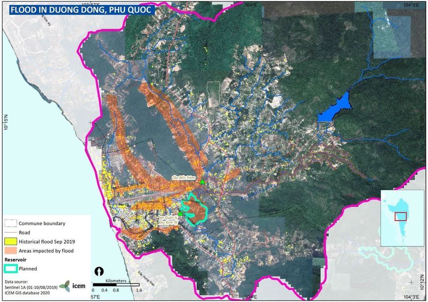
Acknowledgements
The project was established by the World Bank and the Australian Government’s Department
of Foreign Affairs and Trade (DFAT), and is implemented by the Cooperative Research Centre
for Water Sensitive Cities (CRCWSC) and the International Centre for Environmental
Management (ICEM). It is supported by the Australian Water Partnership (AWP) as part of its
Australia–Mekong Water Facility.
The team also acknowledges the contribution and gives thanks to the following agencies who
participated in the study: Ministry of Construction – Technical Infrastructure Agency, Vietnam
Institute for Urban and Rural Planning, Science and Technology Department, Department of
Planning and Architecture, Ministry of Natural Resources and Environment – Institute of
Strategy and Policy on Natural Resources and Environment, City Management Division of Phu
Quoc, Management Board for Public Works of Phu Quoc, Kien Giang Department of
Construction, Kien Giang Department of Planning and Investment, Kien Giang Department of
Natural Resources and Environment and GIZ Vietnam.

                                              3
Executive summary
The vision of this case study is enhanced flood management via a multifunctional
freshwater wildlife conservation park. It presents a unique draw for tourists and a
valuable recreational space for residents of Duong Dong ward, and leads the way in
demonstrating circular economy and sustainability principles in Vietnam.
As a closed island system, and leading national and international tourism destination,
Phu Quoc faces both unique opportunities and challenges. However, if mounting
problems with flooding, water supply, water demand, pollution and waste management
cannot be urgently addressed, its communities as well as its tourism industry will suffer.
Flood risk in Duong Dong ward is high, so doing nothing is no longer an option. This
case study considered the costs and benefits of both a conventional solution for flood
mitigation (dredging and widening Duong Dong River which flows all the way through
downstream Phu Quoc City), and a hybrid approach (developing a multifunctional
freshwater wildlife conservation park linked with a combined waste recycling facility).
This strategic assessment suggests both options will add value to the community but
in very different ways. Both options return around USD 3 of community value for every
dollar invested. The conventional approach provides a slightly stronger overall benefit–
cost ratio (BCR) of 3.3 with a net present value (NPV) of USD 139 million, but at a much
greater cost. The hybrid approach has a BCR of 2.8 and an NPV of USD 65 million.
Results illustrate the choice between scale and scope that is often associated with
comparing conventional and hybrid solutions. While the conventional approach would
offer significant benefits in terms of flood mitigation, the hybrid solution still offers a
strong level of flood protection compared with the baseline. As well as exceeding the
minimum flood protection design requirements, the hybrid solution offers a range of
additional co-benefits, including cost savings from waste disposal and significant
amenity, recreational and biodiversity benefits to park residents, residents of the wider
Phu Quoc City and tourists. The hybrid solution also includes more options for funding
and has a lower financing requirement. This lower cost may enable inclusion of
additional retreat adapt or defend flood mitigation measures and/or free public funds
for spending on other investment priorities. The choice between options will ultimately
be for policy makers to decide how to best allocate scarce resources. This initial
strategic assessment also highlights the value of further investigating and applying the
Integrated Urban Flood Management (IUFM) approach.
The hybrid solution also attempted to go beyond water management to show how
circular economy thinking can apply to both water and waste management and present
integrated solutions. Across the whole island, Phu Quoc should look at how to minimize
the import of resources and more efficiently and sustainably use its existing resources.
The goal should be a self-sustaining island that promotes inclusive development,
safeguarding the environment and the needs of local communities as well as growth of
the tourism sector. Circular economy approaches including hybrid solutions can present
‘win-win’ solutions to balance competing needs and create opportunities for public–
private partnerships and long term community value.
Finally, the case study adds to a growing list of practical applications of a 5-step
Integrated Urban Flood Management (IUFM) framework in the Greater Mekong region.
For information on the IUFM methodology see the IUFM Manual.

                                             4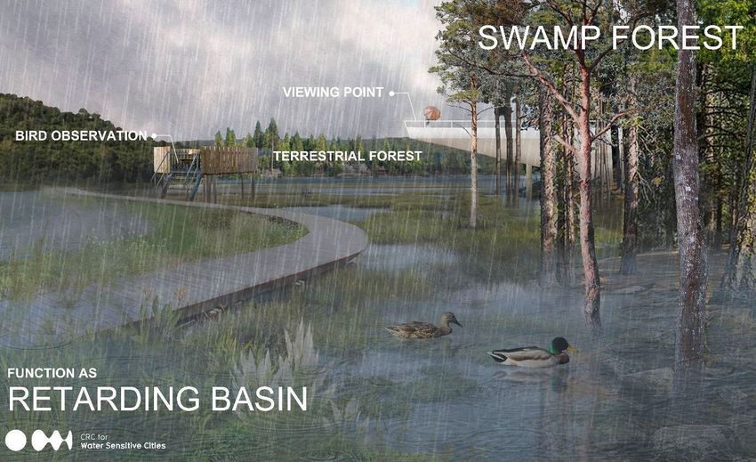
Contents
Acknowledgements ............................................................................................................ 3
Executive summary ............................................................................................................ 4
List of figures ...................................................................................................................... 6
Abbreviations ...................................................................................................................... 7
Project background ............................................................................................................ 8
Case study methodology.................................................................................................. 10
   Stakeholder engagement .................................................................................................... 12
1. Define your urban system context ............................................................................... 14
   1.1. Growth creating both opportunities and challenges .................................................. 14
   1.2 Planned infrastructure improvements ........................................................................ 16
   1.3 Sustainability initiatives on the island ......................................................................... 18
2. Undertake a flood risk assessment ............................................................................. 19
   2.1 Flood challenges in Phu Quoc City and Duong Dong ward ........................................ 19
3. Identify context-appropriate solutions ........................................................................ 22
   3.1 The conventional solution .......................................................................................... 22
   3.2 The hybrid approach .................................................................................................. 23
   3.2.1 Retarding basin ...................................................................................................... 24
   3.2.2 Constructed wetland and stormwater harvesting .......................................................... 26
   3.2.3 Eco-tone restoration ............................................................................................... 27
   3.2.4 Higher ground for commercial and residential development ................................... 28
   3.2.5 Combined waste recycling facility ........................................................................... 29
4. Value and choose interventions .................................................................................. 32
   4.1 Overall BCR .............................................................................................................. 32
   4.2 Comparison of costs .................................................................................................. 32
   4.3 Benefits ..................................................................................................................... 34
   4.4 Distribution of costs and benefits ............................................................................... 35
   4.5 Sensitivity testing ....................................................................................................... 36
5. Identify appropriate funding and financing mechanisms .......................................... 38
   5.1 Enabling policy and strategy ...................................................................................... 38
   5.2 Recognizing and valuing investment options that support policy objectives ............... 39
   5.3 Legal framework for green finance............................................................................. 40
   5.4 User fees and taxation ............................................................................................... 40
   5.5 Demonstration projects .............................................................................................. 40
   5.6 Leveraging private investment and public, private and community collaboration........ 41
   Box 1: Examples of collaboration for sustainability already in place on Phu Quoc ........... 42
6. Recommendations and next steps .............................................................................. 43

                                                                   5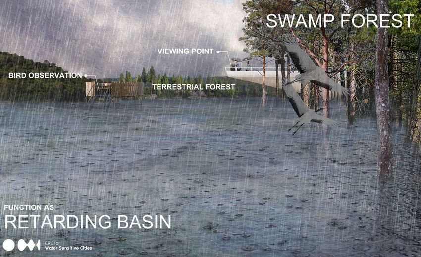
List of figures
Figure 1: Connections between this case study and other projects, programmes and plans in
Phu Quoc. ............................................................................................................................. 9
Figure 2: IUFM process....................................................................................................... 10
Figure 3: National stakeholder involvement in the Phu Quoc case study............................. 12
Figure 4: Beachfront in Duong Dong Town (left), Phu Quoc night market (right) – one of Duong
Dong Town’s main attractions. ............................................................................................ 14
Figure 5: Existing Duong Dong WSS. ................................................................................. 15
Figure 6: Dong Cay Sao landfill in Cua Duong commune (left) and pollution at Ong Tri Creek
flowing to Duong Dong River (right). ................................................................................... 16
Figure 7: Wetland ecosystem in the planned retention basin............................................... 17
Figure 8: Wetland ecosystem in the planned retention basin............................................... 17
Figure 9: Objectives of World Bank’s ProBlue project. ........................................................ 18
Figure 10: August 2019 flooding in Phu Quoc. .................................................................... 19
Figure 11: Number of houses flooded and associated damage by administrative unit in 2019
historical flood event. .......................................................................................................... 20
Figure 12: Historical flood extent in Duong Dong Town. ...................................................... 21
Figure 13: Planned widening of Duong Dong River for flood mitigation. .............................. 22
Figure 14: Transect overview of the components of the hybrid approach. ........................... 23
Figure 15: Elements of the hybrid solution overlaid on map of the current site. ................... 24
Figure 16: Indicative design of retarding basin showing controlled relief point (top) and transect
overview showing placement of the spillway and culvert, integrated as a road or walkway
(bottom). ............................................................................................................................. 25
Figure 17: Offline constructed wetland system (left), gross pollutant trap system (right). ..... 26
Figure 18: Design of wetland conservation park with landscaped features for recreation and
nature observation during dry season (top), minor flooding (middle) and extreme flooding
events (bottom). .................................................................................................................. 28
Figure 19: Higher ground for future commercial and residential development. .................... 28
Figure 20: Workers sorting waste at a waste recycling facility (output 50 tons per day) in Quynh
Coi, Thai Binh Province (top); composting area to turn organic waste into fertilizer for
agriculture (middle); compost products produced from organic waste (bottom). .................. 31
Figure 21: Comparison of capital costs: hybrid (top), conventional (bottom). ....................... 33
Figure 22: Comparison of net and cumulative benefits over time: hybrid (top), conventional
(bottom). ............................................................................................................................. 34
Figure 23: Benefit types and their value (hybrid solution). ................................................... 35
Figure 24: Distribution of costs and benefits (hybrid solution).............................................. 36
Figure 25: Range of outcomes identified through sensitivity analysis. ................................. 36
Figure 26: Volunteers collect waste at a beach in Duong Dong township for Phu Quoc
Environment Day 2020........................................................................................................ 42

Table 1: Comparison of overall BCR: hybrid (left) and conventional (right)                                                            34
Table 2: Comparison of capital costs: hybrid (left) and conventional (right)                                                          35

                                                                    6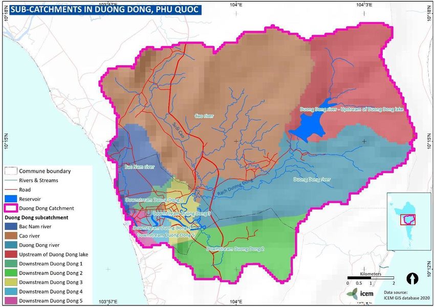
Abbreviations
AHD         Australian height datum
ARI         average recurrence interval
AWP         Australian Water Partnership
BCA         benefit–cost analysis
BCR         benefit–cost ratio
COD         chemical oxygen demand
CPC         City People’s Committee
CRCWSC      Cooperative Research Centre for Water Sensitive Cities
DFAT        Australian Government Department of Foreign Affairs and Trade
DOC         Department of Construction
GEDSI       gender equality disability and social inclusion
GHG         greenhouse gas
GIS         geographic information system
HCMC        Ho Chi Minh City
HEC-HMS     Hydrologic Engineering Center-Hydrologic Monitoring System
HEC-RAS     Hydrologic Engineering Center-River Analysis System
ICEM        International Centre for Environmental Management
IFC         International Finance Corporation
INFFEWS     Investment Framework for Economics of Water Sensitive cities
IOT         Internet of Things
IUFM        Integrated Urban Flood Management
IWRM        Integrated Water Resources Management
IWRMA       Integrated Water Resources Management Assessment
LEED        Leadership in Energy and Environmental Design
MBR         membrane bioreactor
NbS         nature-based solutions
NGO         non-government organization
NPV         net present value
ODA         Official Development Assistance
OECD        Organisation for Economic Cooperation and Development
PPC         Provincial People’s Committee
PPP         public–private partnership
RCP         Representative Concentration Pathway
SWMP        Sustainable Water Management Project
WSS         water supply system
WWTP        wastewater treatment plant

                                    7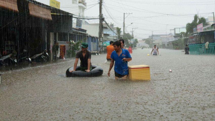
Project background
Now and in the future, cities need integrated solutions to complex challenges. Floods are the
most frequent natural disaster globally, and cause more damage than any other weather or
non-weather-related event. And flood-related damages are expected to grow, driven by
urbanization, land use changes and climate uncertainty. Compared with conventional ‘gray’
infrastructure by itself, nature-based solutions (NbS) such as wetland parks, raingardens,
bioswales, green roofs and walls, can involve less upfront investment, can be more scalable
and flexible and generate a range of environmental, economic and social co-benefits beyond
flood management.

A range of innovative hybrid approaches to integrated urban water management are already
operational across the Asia–Pacific region. The increasing recognition of hybrid approaches
that integrate NbS reflects the changing nature of societies across Asia and the increasing
aspirations for improved environmental quality, community health and economic prosperity.
However, sometimes it can be difficult for decision makers to justify using NbS, or hybrid
solutions compared with conventional measures.

Responding to this challenge, the Cooperative Research Centre for Water Sensitive Cities
(CRCWSC) and the International Centre for Environmental Management (ICEM) have been
working closely with national government agencies in Thailand and Vietnam to identify and
evaluate the full range of market and non-market benefits of NbS, as well as considering
appropriate financing and investment models.

The CRCWSC has developed and trialled the innovative Investment Framework For
Economics of Water Sensitive cities (INFFEWS) which comprises a Benefit–Cost Analysis
(BCA) Tool and a Value Tool that adjusts existing non-market values for application in new
contexts. These tools have been trialled extensively in Australia as well as in several cities in
China. The current project now applies them to the Mekong region, focusing on Thailand and
Vietnam. Four detailed case studies across Thailand and Vietnam demonstrate the Integrated
Urban Flood Management process and the assessment including quantifying market and non-
market benefits of NbS in monetary terms.
This case study is associated with a parallel World Bank-funded, ICEM-implemented study
Integrated Water Resources Management Assessment – Phu Quoc Sustainable Water
Management Project. That study developed a knowledge base on water resources, water
services and institutional capacity needs for water management on the island. Both projects
feed into the World Bank’s broader investment program with the Kien Giang Provincial
People’s Committee (PPC) on the island – the Sustainable Water Management Project to
address urgent water infrastructure gaps. That investment program includes a wastewater
treatment plant (WWTP) in Duong Dong with a capacity of 10,000 m3/day, about 170.5 km of
collection sewers and about 8,000 household connections. Figure 1 illustrates the connections
between these initiatives.

                                               8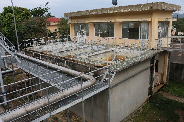
Figure 1: Connections between this case study and other projects, programmes and plans in
Phu Quoc.
Source: Project team.

                                           9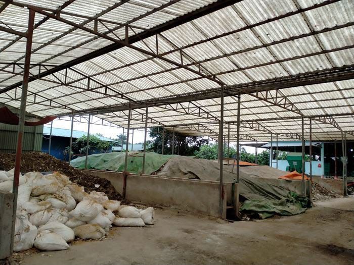
Case study methodology
Each case study follows the 5-step IUFM process for identifying, valuing and choosing an
appropriate mix of flood management interventions for a particular context.

Benefit–cost analysis (BCA) was adopted because it is a rigorous and accepted methodology
for comparing the value to the community of different options. BCA can be used for a range of
purposes including initial scoping of strategic concepts, detailed comparison of options, and
review of whether a project, program or regulation has delivered the promised benefits. This
analysis assesses the proposed strategic concepts.

Figure 2: IUFM process.
Source: Project team.

                                             10
The case study began with an initial site visit and consultations with government agencies.
The flood risk assessment stage was informed by the Integrated Water Resources
Management Assessment – Phu Quoc Sustainable Water Management Project for which
island-wide climate change assessments and flood modelling were undertaken.
This case study compares the planned conventional response to flooding – dredging and
widening the Duong Dong River – with a potential hybrid solution of a multifunctional wetland
park that both mitigates flooding and delivers a range of other co-benefits. The hybrid solution
was developed based on national and international best practice and the expertise of the
project team. The appropriateness of the proposed solution was tested with national
stakeholders during the second training module delivered 30–31 March 2021.
This case study presents 2 separate BCAs relative to a ‘do nothing’ scenario: one for the
conventional response and one for the hybrid solution. This approach involved compiling cost
and benefit estimates for the components of each response. Costs were taken mainly from
national cost norms and official statistics. This data was supplemented with data from other
countries in Asia where there were gaps. A key resource was a previous study conducted by
the CRCWSC with support from the World Bank on valuing the benefits of NbS for IUFM in
Kunshan, China. 1
Benefits were calculated using a mix of official statistics and supplemented by the INFFEWS
Value Tool allows which allows practitioners to adjust and transfer benefit valuations from
relevant research studies. For example, benefits for flood protection were estimated using
value transfer from a study on willingness to pay for flood reduction in Nghe An, in Vietnam’s
Central Region. 2 The value was then adjusted using official house prices in Phu Quoc
compared with Nghe An, and for relatively lower flood intensity in Phu Quoc compared with
Nghe An. A final value emerged by multiplying the willingness to pay per household in the
study with the estimated number of flood-affected people within a 500 m radius of the Duong
Dong River. The full cost and benefit assumptions can be found in the Annexes.
Another important consideration in the methodology is how benefits and cost change over
time. Some benefits may be one-off, such as increases in property values. Other benefits will
build over time, such as avoided flood damage. It is also important to build local technical and
financial capacity to maintain assets so they continue to deliver value, as well as defining who
will be responsible for maintenance. Additionally, the model recognizes benefits are more
valuable now than in say 5, 20 or 40 years’ time. The time value of money – or the ‘discount
rate’ is usually set according to national standards, and commonly ranges from 2–6%. In this
case, we assumed a discount rate of 4%.
After the cost and benefit information was added to the model, an important final stage was
sensitivity testing. This stage asks how strong the conclusions are when significant changes
are made to the assumptions. In cases such as these where the BCA is strategic, without
precise costs and benefits, undertaking this step is important for establishing the validity of
findings. In this case study, sensitivity testing involved increasing and decreasing costs and
benefits by 30%, running the model 1,000 times and building a distribution of probabilities.
Similar sensitivity analysis was done for different discount rates and key assumptions such as
1
Wishart, M., Wong, T., Furmage, B., Liao, X., Pannell, D. and Wang, J. (2021). The Gray, Green, Blue
Continuum: Valuing the benefits of nature-based solutions. Washington DC: World Bank.
2
Reynaud, A. and Nguyen, M. H. (2016). ‘Valuing flood risk reductions’. Environmental Modeling and
Assessment, 21(5), 603–617.
11the take up rate of small scale NbS by private parties and the period of analysis. Results of
the sensitivity testing are presented in Chapter 4.
Financing and funding recommendations were formulated based on international and national
good practice and innovation. In particular, this study considered how examples from Australia
could be applied to Phu Quoc.
Stakeholder engagement
Strong stakeholder engagement and co-creation of solutions was critical to the case study
approach. As well as promoting IUFM approaches, the project’s parallel goal was to build
capacity and create a community of practice of national champions who have the necessary
tools and knowledge to identify, evaluate and quantify NbS within a robust economic
framework.
At the beginning of the process, the case study methodology included extensive stakeholder
engagement, which helped to narrow down the selection of potential case study sites in line
with government priorities. Aligning with the steps in the IUFM process, a series of capacity
building and consultation workshops were organized throughout the project that brought
together key stakeholders and experts to provide feedback and discuss broader implications
including opportunities and challenges for scaling up. To ensure continuity of learning
outcomes and to support the development of a community of practice, the same participants
were invited to each event.
Figure 3 shows the agencies that were involved in the case study at national, provincial and
ward level.
Figure 3: National stakeholder involvement in the Phu Quoc case study.
Source: Project team.
12Three workshops were held:
• 1. Foundational training for national stakeholders (21–22 January 2021): This
2-day event provided a high-level overview and introduction of the topics, including
examples of NbS as multifunctional water infrastructure in Australia, China and
Vietnam. The session also introduced the project’s four case study locations (two in
Vietnam and two in Thailand), covering Steps 1 and 2 of the IUFM process and seeking
feedback on whether the project team had adequately understood the local context
and issues faced.
• 2. Identifying Integrated IUFM and NbS Interventions (30–31 March 2021): The
second session focused on the Step 3 of the IUFM process, presenting the hybrid
solutions and the anticipated benefits for the two Vietnamese case studies (one in Phu
Quoc and the other in Ho Chi Minh City). Key questions put to stakeholders focused
on local feasibility, whether the solutions adequately responded to the issues identified
in the previous phase, and whether the benefits were accurately described.
• Valuing and comparing IUFM solutions (18 June, 26 November 2021): A final
session was held separately for each case study focused on Steps 4 and 5 of the IUFM
process, presenting the results of the BCA analysis, and outlining potential modalities
for funding and financing. A key goal is to test the assumptions in the model with
participants to ensure their appropriateness.
131. Define your urban system context
1.1. Growth creating both opportunities and challenges
Located 120 km from Rach Gia City and 45 km from Ha Tien City, Phu Quoc City plays a
strategic role in the socio-economic development of Kien Giang Province. Known as ‘Pearl
Island’, Phu Quoc is also the largest island in the country, and has become a popular
destination for foreign and domestic tourists. In December 2020, the National Assembly
Standing Committee passed a resolution establishing Phu Quoc City from March 1 2021,
becoming the first island city in Vietnam.
Historically, Phu Quoc’s economy was based on fishing and agriculture. Over the past 10
years, the city has posted high and stable economic growth, attributed to fast-growing tourism
and service sectors and significant infrastructure investments. The number of tourists has
been increasing steadily in recent years, reaching over 5 million in 2019, yielding an estimated
revenue of more than 5.25 trillion VND (over USD 200 million). Under the Phu Quoc
Construction Master Plan, the island is envisioned to become an international destination and
a science and technology hub for the southeast Asian region, balancing economic
development with sustainability and preservation of historic monuments and cultural heritage.
The plan broadly covers all sectors, with a focus on technical infrastructure – roads, airports,
ports, electricity, water supply, drainage and wastewater management, solid waste
management – and on tourism facilities – resorts, eco-tourism and forests.
Situated within Duong Dong catchment, Duong Dong ward is the largest urban agglomeration
in the city (with a population of approximately 45,000) and constitutes the administrative and
economic centre. Phu Quoc night market, and long, straight beaches are major attractions in
Duong Dong ward, although much of the beachfront is privatized; public access is limited with
access mostly via hotels.
Figure 4: Beachfront in Duong Dong Town (left), Phu Quoc night market (right) – one of Duong
Dong Town’s main attractions.
Sources: Project team, 2020 (left), Marco Verch (right).
Concerns are emerging that continued expansion of the tourism sector together with rapid
urban growth are placing significant pressure on water resources and endangering the island’s
unique ecosystems. Phu Quoc faces an array of critical challenges related to water resources,
including water scarcity in the dry season, localized flooding and environmental pollution.
With only 16–17% of annual precipitation falls in the dry season, water scarcity has become a
significant concern, particularly in Duong Dong ward. Long periods of hot days, little rainfall
14and dissipated stream flows mean surface water storages at Duong Dong reservoir experience
significant decreases in dry season.
The Duong Dong water supply system (WSS) – the only centralized public water supply
network in Phu Quoc City – sources raw water from the Duong Dong reservoir – the island’s
only major storage basin with an area of 16 km2 and design capacity of 4.13 million m3
(Figure 5). The Duong Dong WSS operates at maximum capacity 24,000 m3/day, and
provides water supply services for all of Duong Dong ward, and parts of An Thoi ward and
Duong To commune. For example, in March 2020, Phu Quoc City People’s Committee
reported water level in Duong Dong reservoir decreased by 5–6 cm on average every day.
Such drops in water availability often force Duong Dong WWTP to reduce its production to
70–80% of capacity, resulting in water supply scarcity for people and tourists in Duong Dong
ward. Under the current meteorological conditions and with existing reservoir operating rules,
simulations suggest water demand would exceed supply on 470 days over 20 years, with a
maximum drought duration of 93 days.
For other areas of the island, communities and businesses mostly draw water directly from
aquifers, causing concerns about unregulated extraction and over-extraction.
Figure 5: Existing Duong Dong WSS.
Source: Project team.
Solid waste and wastewater volumes have increased consistently over the past decade, but
civil infrastructure growth has not kept pace. The 2 most populated areas on the island, Duong
Dong and An Thoi wards, experience the worst problems with domestic solid waste. Together,
they account for over 52% of the total volume of domestic solid waste produced per day
(100 tons). The island has no formal waste treatment system, and the remaining landfill in Cua
Duong commune is quickly becoming overloaded. The majority (70%) of the island’s domestic
wastewater is only preliminarily treated by septic tank while the rest is discharged directly to
open channels and water bodies.
Environmental pollution, including a serious problem of plastic waste, affects residents’ quality
of life, threatens natural habitats and biodiversity and hinders the growth potential of the
island’s tourism sector. Surface water pollution occurs in almost all rivers and creeks,
particularly the ones flowing through residential areas such as Duong Dong River and Ong Tri
Creek. The situation is most serious in dry season and is easily observed – water surfaces
are commonly covered in floating rubbish, black water with bad odour is common, and oil
slicks are often evident on the water surface (Figure 6).
15Figure 6: Dong Cay Sao landfill in Cua Duong commune (left) and pollution at Ong Tri Creek
flowing to Duong Dong River (right).
Source: Project team.
1.2 Planned infrastructure improvements
With these concerns, sustainable resources management is among the top priorities of the
Governments of Kien Giang Province and Phu Quoc District. The Phu Quoc Construction
Master Plan developed by Kien Giang PPC emphasizes developing water resources
infrastructure across the island to ensure adequate access to water for all communities as well
as to improve drainage conditions and address wastewater management. To address the most
critical elements of the master plan, Kien Giang PPC is currently developing a proposal for a
Sustainable Water Management Project (SWMP) under the World Bank.
The SWMP will include large scale investment to:
• construct the Cua Can multi-purpose off-stream water storage reservoir to increase
the island’s water security for the dry season and build climate change resilience
• construct a 20.3 km of stormwater drainage network
• establish a separate wastewater collection and treatment system, which includes
Duong Dong WWTP with a capacity of 10,000 m3/day, about 170.5 km of collection
sewers and about 8,000 household connections.
Phu Quoc City is also calling for new investment for a solid waste treatment facility in Ham
Ninh commune, which previously operated but closed in 2020. A second solid waste treatment
facility is planned in Cua Duong commune to be completed by 2030.
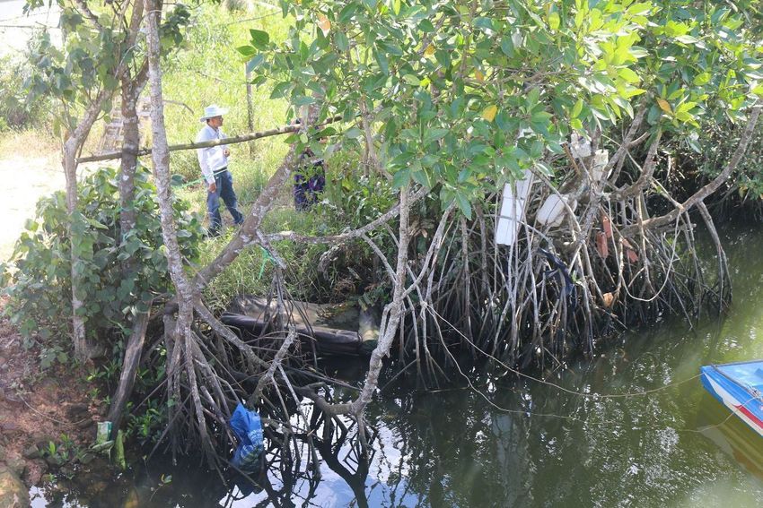
As part of an enhanced drainage network, the planned Duong Dong retention basin is located
adjacent to Nguyen Chi Thanh Road and Doan Thi Diem Road in Duong Dong ward,
approximately 5 km from the estuary (Figure 7). About 150 households, totalling about 600
residents, currently reside on the site. The residents hold a certificate of agriculture land use
right; i.e. the land is legally perennial agricultural land.
The area is currently a natural channel of Duong Dong River. Multiple wetland plants are
present, including Melaleuca, Rhizophora apiculate, Hibiscus tiliaceus, Sonneratia, Annona
glabra (Figure 8). Encroachment is common, since most residents have settled on the land
informally.
16Figure 7: Wetland ecosystem in the planned retention basin.
Source: Project team.
Figure 8: Wetland ecosystem in the planned retention basin.
Source: Project team.
171.3 Sustainability initiatives on the island
Recognising these challenges and the threats they pose to the island’s communities, economy
and environment, several sustainability initiatives have emerged in recent years. Ecotourism
and sustainable tourism are on the rise, and several large hotel chains have incorporated
circular economy principles into their operations. For example, Radisson Blu Phu Quoc was
the first partner to collaborate with La Vie Water for the ‘La Vie Glass’ project to encourage
the hospitality industry to use glass bottles and other environmentally friendly materials instead
of plastic. Radisson Blu Phu Quoc also runs the Radisson Blu Bee Garden to educate
communities and visitors on the importance of honeybees and to support local food
sustainability. Bamboo Step supplies a number of the major hotels with bamboo straws
including Radisson Blu, JW Mariott and Fusion.
Outside of the hospitality industry, several initiatives are tackling sustainability, focusing on
plastic waste. The World Bank ProBlue program (implemented jointly with the International
Finance Corporation (IFC)) supports Government of Vietnam plastic waste reduction
solutions. The program has three objectives (Figure 9).
Figure 9: Objectives of World Bank’s ProBlue project.
Source: World Bank.
Chapter 5 provides further examples of public–private and community collaboration supporting
more sustainable waste management on Phu Quoc Island.
182. Undertake a flood risk assessment
2.1 Flood challenges in Phu Quoc City and Duong Dong ward
Phu Quoc receives average annual precipitation of about 3,000 mm. Rainfall is unevenly
distributed throughout the year, falling predominantly in the rainy season from May to
November which accounts for 80% of the annual rainfall. During the rainy season, due to the
island’s moderate to steep topography, high precipitation levels quickly generate overland flow
which then drains into the stream networks. With few major natural or anthropogenic storages,
a large proportion of rain is converted to runoff and descends to the island’s few coastal
estuaries before being discharged to the sea.
The coverage and capacity of formal drainage services are very low. Only Duong Dong ward
(and An Thoi ward) have some form of drainage and flood management (a combined system).
However, these ad hoc and poorly maintained systems are increasingly inadequate to handle
large amount of precipitation in a short period. Poorly planned urban development, increased
impermeable surfaces, encroachment and blockages of natural drainage channels such as
Duong Dong River and Ong Tri Creek (from rubbish and inadequate dredging) have disrupted
Duong Dong’s natural drainage mechanisms. As a result, floodwater does not drain fast
enough to the sea during heavy rainfall events, causing localized flooding each rainy season.
Such flooding is exacerbated by tidal effects at the estuaries.
In August 2019, unprecedented heavy rains hit Phu Quoc, which received 1,170 mm of rain
over 10 days (accounting for up to 48% of average annual rainfall) (Figure 10). Island-wide,
8,424 houses were flooded, and 23 other houses collapsed, subsided/ cracked or lost their
roof. Total estimated housing damage was 83 billion VND, or over USD 3.6 million. Over 60 km
of roads were flooded and damaged, with average depth of 0.7 m. Almost 2,000 people had
to be evacuated.
Figure 10: August 2019 flooding in Phu Quoc.
Source: Tuoi Tre News.
Duong Dong ward was particularly badly affected by the flooding, accounting for 65% of
flooded houses and 24% of flooded roads (Figure 11). Main roads that were flooded included
19Tran Phu Road (4 km, 90 cm deep), Cach Mang Thang 8 Road (2 km, 120 cm deep), Nguyen
Trung Truc Road (1 km, 100 cm deep) and Mac Cuu Road (1 km, 130 cm deep). In residential
areas of Duong Dong ward, average flood depth was 50 cm, disrupting local communities and
tourists and damaging household appliances. Heavily developed residential areas and
technical infrastructure contributed to this disproportionate impact.
3,000,000 6000
2,500,000 5000
2,000,000 4000
houses
USD
1,500,000 3000
1,000,000 2000
500,000 1000
- 0
Duong An Thoi Cua Duong Cua Can Duong To Ganh Dau Bai Thom Ham Ninh
Dong
Estimated damage Number of houses flooded
Figure 11: Number of houses flooded and associated damage by administrative unit in 2019
historical flood event.
Source: Economic Division, Phu Quoc City People’s Committee, 2020.
20Figure 12: Historical flood extent in Duong Dong Town.
Source: Project team.
Duong Dong ward is prone to both pluvial and fluvial flooding. Projected increases in both
average precipitation in the wet season – i.e. daily maximum rainfall and 5-day maximum
rainfall – mean pluvial flooding is expected to worsen in both magnitude and intensity. With
limited data available, indicative results of HEC-RAS hydraulic modelling conducted in the
ongoing Phu Quoc Integrated Water Resources Management Assessment (IWRMA) project
showed the water level peaked at a maximum of 2.0 m AHD for an event of maximum hourly
rainfall of 72 mm.
In terms of fluvial flooding, HEC HMS catchment hydrological rainfall runoff modelling for the
IWRMA study (ICEM 2021) indicated a 50-year average recurrent interval (ARI) event would
result in a maximum flood height of 2.17 m AHD under climate change scenario RCP4.5 to
2050.
An additional significant issue across Phu Quoc is the anticipated increased storm surge
heights from climate change. At present, the expected storm surge height under a severe
event is 1.2 m. However, this height increases to 2.0 m by 2050 and to 2.5 m by 2100 due to
climate change under the RCP4.5 and RCP8.5 scenarios respectively. The lower reaches of
the Duong Dong River are of concern, facing the potential impacts of combined storm surge
and flood events. This case study did not directly consider solutions to coastal storm surge,
however future defence responses such as barriers, breakwaters and gates would need to be
applied for both the conventional and hybrid scenarios.
Expected impacts from flooding in Duong Dong ward are:
• travel disruption
• damage to houses
• business closures
• pollution due to overflow of wastewater and floating garbage in floodwaters
• potential loss of life during extreme events.
213. Identify context-appropriate solutions
3.1 The conventional solution
The threat of flooding in Duong Dong ward is such that ‘doing nothing’ is no longer an option.
The conventional solution outlined in the 2014 Duong Dong urban zoning plan is to widen the
Duong Dong River downstream, from a planned retention lake on the eastern outskirts of the
ward to the coast: an area approximately 5 km by 100 m wide, with dredging of an additional
2 m from the current river bed depth. Levees will be constructed on both banks of the river,
with levee height of 1.8 m for the 3 km section from the estuary to the Hung Vuong Bridge and
2.2–3.0m for the 2 km section from the Hung Vuong Bridge to the planned retention lake.
The conventional response is expected to provide a strong level of flood protection by
increasing floodwater storage and the drainage capacity of the Duong Dong River to mitigate
flood risk during extreme rainfall events, equal to a 100-year ARI event. During such an event,
the conventional response would decrease downstream water levels by 1.7m. 3
Since downtown residential areas are heavily developed on both sides of the river, widening
it would involve acquiring large areas of urban residential land and resettling thousands of
people. Compensation would be significant, and social disruption would be expected.
Figure 13: Planned widening of Duong Dong River for flood mitigation.
Source: Phu Quoc Construction Master Plan.
3
Sekkei Civil Engineering Ltd (2014). Duong Dong Urban Zoning Plan. Department of Construction.
Kien Giang Province People's Committee.
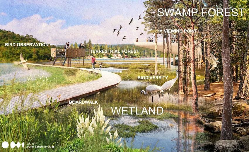
223.2 The hybrid approach
The hybrid approach instead focuses on the planned Duong Dong retention lake, proposing
to develop it into a multifunctional freshwater wildlife conservation park with a total area of
46 ha (Figures 14 and 15).
The components of the approach are as follows: 4
1. a retarding basin to reduce flooding to the downstream community around Duong Dong
River
2. a constructed wetland for stormwater harvesting and purification
3. an eco-tone restoration to serve as an ecotourism destination in Duong Dong ward
4. higher ground for high quality development and land reserved for resettlement
5. a combined waste recycling facility to demonstrate circular economy by turning organic
waste and sludge into compost or biogas.
Figure 14: Transect overview of the components of the hybrid approach.
Source: Project team.
4
Managed aquifer recharge (MAR) was initially included as part of the hybrid strategy. However, it was
removed after feedback from expert consultation workshops and from findings from the ICEM IWRMA
project which indicated the high groundwater table made the site unsuitable for MAR.
23Figure 15: Elements of the hybrid solution overlaid on map of the current site.
Source: Project team.
The hybrid solution capitalizes on the Duong Dong River’s pre-existing natural channel. It
would be significantly cheaper to implement due primarily to the lower compensation costs for
acquiring land and resettling people, given the land is designated as perennial tree cultivation
land.
The hybrid approach offers a range of social, economic and environmental co-benefits:
• increased flood protection for a 1-in-30-year flood event
• additional water supply from stormwater harvesting (reducing the recurring cost of
park maintenance)
• improved amenity and recreational opportunities
• improved biodiversity
• delayed cost of infrastructure investment in a solid waste treatment facility in Cua
Duong commune
• revenue generation from compost sales
• minimized social disruption via an in-situ resettlement scheme.
Each component of the hybrid strategy is explained in detail below.
3.2.1 Retarding basin
The first component is to design the wetland park as a retarding basin, so that water will
backup from the downstream bottleneck to inundate a larger area, mitigating the river’s limited
24drainage capacity. Floodwater will be released downstream in a controlled way through a relief
point (Figure 16, top) to manage peak flows and decrease flood risk to the downstream urban
area. This component would involve equipping the downstream interface with Duong Dong
River with appropriate hydraulic structures including a weir, gates, pumps and pipes (to enable
the flood detention operation) and an embankment/levee immediately downstream of the
wetland park (to contain the water). This feature could be integrated into the conservation park
design as an aesthetic, landscaped walkway or road (Figure 16, bottom).
Figure 16: Indicative design of retarding basin showing controlled relief point (top) and transect
overview showing placement of the spillway and culvert, integrated as a road or walkway
(bottom).
Source: Project team.
The total area of the retarding basin is estimated at 42.5 ha, including a retention lake as
permanent water body, the wetland and the swamp forest. The area will be excavated to 5 m
compared with the current bed, and shaped in a terraced form. A 2.5 km levee will contain the
floodwater.
Compared with the conventional approach, modelling results in the Duong Dong urban zoning
plan indicate a lower overall protection level against extreme flood events, but still a significant
25benefit compared with the do-nothing scenario. The design provides an approximate
protection level against a 1-in-30-year ARI event, which exceeds the minimum flood protection
design standards for comparable infrastructure (against a 1-in-10-year event). 5
3.2.2 Constructed wetland and stormwater harvesting
The constructed wetland component functions as a water cleansing system that will harvest
stormwater discharged from the upstream Duong Dong catchment and improve the
stormwater quality as it flows into the urbanized area. Although the upstream area is sparsely
populated, there is no formal wastewater system so households discharge domestic
wastewater into open channels or natural water bodies which then flow into the river.
To improve water quality while maintaining a strong level of flood protection, an ‘offline’ system
is recommended, which means the constructed wetland runs parallel to the Duong Dong River.
A divergent structure will be installed to divert a proportion of the dry weather flow into the
wetland for treatment, with high flows allowed to bypass via an adjacent waterway (Figure 17).
In the system, water flows through a series of densely vegetated wetland species, where it is
treated via microorganisms in reedbeds and other aquatic plants, whose root systems break
down the contaminated effluent. The water is then channelled back into the river mainstream,
or harvested for internal public uses such as irrigation, road cleaning and firefighting. In
Vietnam, local species that have been successfully used in wetland systems include
Phragmites australis and Typha angustifolia. 6 In the wetland, a gross pollutant trap can help
manage some of the solid waste problems by trapping litter and coarse sediment.
The constructed wetland will have an area of 1 ha, and the stormwater harvesting system will
have the capacity to harvest up to 350 m3/day of stormwater. When water levels are normal,
water in the retention lake can be recirculated through the wetland to maintain water quality
and the park’s amenity value. The wetland is a part of the retarding basin, so during flood
events, when floodwater exceeds a certain threshold, the wetland will be flooded.
Figure 17: Offline constructed wetland system (left), gross pollutant trap system (right).
Sources: Melbourne Water (left), City of Melbourne (right).
5 See TCVN 7957:2008 Drainage and sewerage – External Networks and Facilities. Note there is no
national design standard for retention/detention lakes.
6
Anh, B.T.K. (2018). ‘Selection of suitable plant species for wastewater treatment by constructed
wetland at the Formosa Ha Tinh Steel Company’, Vietnam Journal of Science and Technology, 56(2C),
157–163.
263.2.3 Eco-tone restoration
A small scale, accessible alternative to the mainly beach-based tourism offerings on Phu Quoc
island, focusing on conservation and showcasing of native species presents a significant and
unique draw for tourists. This component would be particularly useful for Duong Dong ward
which lacks attractions besides the beachfront. Such an initiative would also capitalize on the
increasing interest from domestic and international visitors in ecotourism.
The hybrid approach incorporates a 10 ha eco-tone restoration area featuring both aquatic
and terrestrial fauna and flora. Forests and wetlands showcase a diversified habitat, with
viewpoints for wildlife observation. Amenity for eco-tourism could be designed on walkways
above the lake, elevated to withstand various water levels. It could be integrated into the local
tourism activity program with guided tours to show tourists species native to Phu Quoc and
the Kien Giang Biosphere.
Tourism facilities could be developed at designated point so visitors can observe wildlife. The
facilities could be architecturally designed on platforms to easily cope with temporary rises in
water levels.
Currently, local residents and tourists have limited amenity and recreational opportunities and
limited public access to the beachfront in Duong Dong ward. The conservation park would
create significant amenity and recreational benefits for both these groups.
The following design renderings illustrate how the wetland conservation park could be
constructed as a dynamic and natural habitat during the dry season, minor and extreme
flooding events.
27Figure 18: Design of wetland conservation park with landscaped features for recreation and
nature observation during dry season (top), minor flooding (middle) and extreme flooding
events (bottom).
Source: Water Sensitive Cities Australia.
3.2.4 Higher ground for commercial
and residential development
This component takes advantage of the cut
materials from the soil excavation to create
the retarding basin and fill higher ground to
create a gradient in the park permanently
above inundation levels.
The higher ground will be reserved to
develop both an affordable apartment
building and high-quality development
Figure 19: Higher ground for future commercial and
properties such as luxury apartments, residential development.
boutique eco-hotels or restaurants. This Source: Project team.
28component capitalizes on the projected increase in land value associated with the
conservation park.
One of the anticipated challenges for this component is acquiring land from residents currently
residing within the site. Creating this higher ground with developable land could offset some
compensation costs, via land exchange from the current low-value agricultural land, to the
higher value apartments.
3.2.5 Combined waste recycling facility
Phu Quoc generates a significant amount of organic waste such as food waste, particularly
from its hospitality industry. Instead of placing pressure on the island’s at-capacity landfill sites,
parts of the collected food waste and organic segments of municipal waste could be
beneficially reused, e.g. turned into compost. There will also be demand to manage sewage
sludge safely and sustainably when the Duong Dong WWTP comes online. Sewage sludge
contains organic matter that can be transformed into energy and/or green chemicals.
Moreover, resource recovery from these wastes has become an increasing new focus of
wastewater management, to develop more sustainable processes in a circular economy
approach.
The common approach to recover these resources is via anaerobic digestion. This series of
biological processes involves microorganisms breaking down biodegradable material in the
absence of oxygen. It has been effectively tested and is considered the most commercial
method to convert organic wastes such as municipal activated sludge and the food and
organic portion of municipal waste into resources such as compost and methane-rich biogas.
Anaerobic co-digestion is a technology providing simultaneous digestion of different solid and
liquid wastes. The technology achieves more a appropriate carbon-to-nutrient ratio by co-
digesting nutrient-rich and highly COD-concentrated wastes. Further, co-digestion provides
higher efficiency in terms of land and equipment utilization by digesting various waste streams
in a single facility. The end product of this process – compost – could reduce demand for
imported agricultural fertilizer. This strategy demonstrates an opportunity to introduce and
promote circular economy principles on Phu Quoc Island, and helps to relieve the solid waste
management pressure on the inadequate system currently in place.
The proposed approach is to construct and operate a combined waste recycling facility that
turns organic waste and sludge into compost using co-digestion via a public–private
arrangement. The proposed facility will be located on the perimeter of the site and away from
the zoned commercial and residential area with an appropriate buffer zone to dispel any poor
odours for park visitors. 7 The facility has an assumed capacity to produce a maximum of
50 tons of compost per day and 1,500 tons of compost per year. This amount represents
around three-quarters of the island’s fertilizer consumption in 2020.
The compost could be sold at a below-market average price for organic fertilizer. Additionally,
constructing a combined waste recycling facility could delay investment in a second solid
waste treatment facility at Cua Duong commune by approximately 5 years.
Financial incentives for private engagement are drawn from the revenue generated from
selling compost as an alternative to imported fertilizer. Engagement programs, such as
educational visits by local schools and guided tours, can showcase innovative circular
economy approaches as a unique tourism experience. Collaboration with the not-for-profit
7
Another option is for it to be co located with future solid or liquid waste facilities.
29sector could also be pursued, similar to programs for managing inorganic waste (see
Chapter 1).
An alternative strategy could be constructing a bio-power facility using green waste, which
uses the same anerobic digestion process. Biogas is then converted into electricity, which
could be used onsite or sold to the electricity grid. This case study used composting because
it has lower costs and lower technology and risk management requirements.
30Figure 20: Workers sorting waste at a waste recycling facility (output 50 tons per day) in Quynh
Coi, Thai Binh Province (top); composting area to turn organic waste into fertilizer for agriculture
(middle); compost products produced from organic waste (bottom).
Source: suckhoemoitruong.com.vn.
314. Value and choose interventions
This section provides an overview of the results of the BCA. It compares the conventional
solution and the hybrid approach as described in Chapter 3 to a ‘do nothing’ scenario. Costs
were estimated in Vietnam Dong and converted to current USD. The cost and benefit
components and assumptions across the 40-year project period can be found in the Annexes.
It is important to note this study is a high-level strategic assessment with data limitations. The
main purpose is to ask, given the information available, whether the strategy is worth further
investigation.
4.1 Overall BCR
Overall, both options deliver a strong BCR. The conventional approach Key economic terms
provides a stronger BCR of 3.28, with an NPV of USD 139 million, but
at a much greater cost. The hybrid approach has a BCR of 2.81 and an Net present value:
NPV of USD 65 million. Compared with the conventional solution, it Calculates today’s value of a
provides a broader range of benefits, includes more options for funding future stream of payments
and has a lower financing requirement. This lower cost may free public over the entire life cycle
funds for spending on other investment priorities. including costs and benefits
Hybrid (USD) Conventional (USD) Benefit–cost ratio:
Compares the present value
Benefits 103,119,762 200,349,212
of all benefits with the cost.
Costs 36,647,170 61,149,230 For every dollar spent, the
BCR gives you how much
Net 66,472,592 139,199,982 you will get back in benefits
BCR 2.81 3.28
Table 1: Comparison of overall BCR: hybrid (left) and conventional (right).
Source: Project team.
4.2 Comparison of costs
Table 2 and Figure 21 break down and compare the costs associated with the hybrid and
conventional approaches. The hybrid approach represents just over half (56%) of the costs of
the conventional approach. The high land acquisition costs from resettling and compensating
thousands of people who live on both sides of the Duong Dong River account for the majority
of the costs associated with the conventional solution.
In contrast, the hybrid approach involves resettling fewer people around the retention lake,
and the land is zoned for agricultural purposes which lowers the compensation costs. To
further minimize social disruption, the hybrid approach includes an in-situ resettlement
scheme (see Section 3.2.4) with affordable apartment buildings. Some compensation costs
could also be offset via land exchange from the current low-value agricultural land, to the
higher value apartments.
32You can also read