Cultural Values Assessment: AC36 Consent Application (Te Waitematā) 2311 - Report prepared by: Mahuika Rāwiri - Environment Court
←
→
Page content transcription
If your browser does not render page correctly, please read the page content below
2311

                        Cultural Values Assessment:

                        AC36 Consent Application
                            (Te Waitematā)

Report prepared by: Mahuika Rāwiri
Reviewed by: Morehu Wilson
Dated: 24 August 2018

                                                      1
2312

Table of Contents
1      Statement of Use ......................................................................................................................................... 3
2      Te Ao Māori – The Māori World View ......................................................................................................... 5
3      NGĀTI PAOA VALUES/PRINCIPLES ............................................................................................................... 7
       Te Tapuwae o Ngāti Paoa: The Footprint of Ngāti Paoa ........................................................................... 15
4      He Take Tō Ngāti Paoa ki te Whenua Kura Nei me te moana – The Relationship of Ngāti Paoa to the land
       and sea....................................................................................................................................................... 19
5      Migration, War and Peace ........................................................................................................................ 19
5.2           Cultural connections within the vicinity of the project ..................................................................... 27
5.3           Natural Resources ............................................................................................................................. 27
6      BROAD HISTORICAL CONTEXT TO EXISTING CROWN RELATIONSHIPS...................................................... 28
6.1           He Whakaputanga o te Rangatiratanga o Niu Tīreni - Declaration of Independence 1835 .............. 28
6.2           Te Tiriti o Waitangi 1840 ................................................................................................................... 28
6.3           Treaty Settlement Process................................................................................................................. 30
7   SUMMARY OF CULTURAL HERITAGE VALUES………………………………………………………………………………………..34
7.1    Aspirations ........................................................................................................................................ 36
7.2           Decision-making, co-governance and co-management arrangements ............................................ 36
7.3           Cohesive and comprehensive project planning ................................................................................ 38
7.4           Positive Effects .................................................................................................................................. 38
8     RECOMMENDATIONS................................................................................................................................. 39
9             Bibliography ....................................................................................................................................... 42
10            Attachments....................................................................................................................................... 44

                                                                                                                                                                      2
2313

1   Statement of Use
    Ngāti Paoa Iwi Trust have been engaged by Panuku Development Auckland (Panuku) to
    prepare a Cultural Values Assessment (CVA) relating to the proposal for the 36th America’s
    Cup Resource Consent Application to be held on the Waitematā harbour, Auckland/Tāmaki
    Makaurau.
    The proposal by Panuku is for the construction, occupation, use and maintenance of
    permanent and temporary infrastructure in Freemans Bay necessary to host the 36th
    America's Cup, and to hold the 36th America's Cup and successive America's Cup events to
    2028.
    In reviewing this information it would appear that the adjoining water space will be
    developed to provide for berthage associated with America's Cup activities. This involves the
    removal of existing structures and location of new piles, pontoons and associated structures
    and services.
    The Wynyard Hobson proposal includes the location of structures and undertaking of
    activities within the coastal marine area and on land. A number of key infrastructure
    components that are planned for the development are most likely to not have an adverse
    impact on Māori cultural values, but clarity/certainty around this is still required as the
    project progresses.
    This CVA seeks to respond to the lodgement of resource consents for the coastal marine area
    by Panuku, by:
         ●     Documenting the cultural significance of the project area to Ngāti Paoa, including
               specific sites, features and values; and
         ●     Recommendations to achieve Ngāti Paoa aspirations, and mana whenua
               aspirations for consideration by Panuku.
    For the avoidance of doubt, this CVA provides a high-level overview of the associations and
    broad cultural values of Ngāti Paoa which apply to the cultural landscape within/surrounding
    the proposed project area.
    This is a living document. It will be developed further over time as the information held within
    the whenua is better understood. For example, as further investigations, development and/or
    natural processes occur, we discover additional information to support cultural heritage i.e.
    archaeological and geological records; or other sources of whakapapa or matauranga Māori.
    This document is prepared with the intention of it being continually referred to as a guide to
    decision making.
    Ngāti Paoa strongly encourage Panuku (and key stakeholders, project contractors) to use this
    document and other Ngāti Paoa iwi planning documents during the conceptual and research
    stages of policy and project development for the AC36 proposal (Attachment 5). The
    following Ngāti Paoa iwi planning documents should be referred to:
         •     Ngāti Paoa Iwi Trust, (2013) Interim Ngāti Paoa Iwi Management Plan
         •     Ngāti Paoa Strategic Plan (2015 -2020)
    Using these documents should improve the quality of the design proposal and the
    aspirations/outcomes to be achieved, improve relationships, and lessen the likelihood of
    adverse impacts on the values of mana whenua – consequentially resulting in positive
    impacts/outcomes. It is noted that the pre-design and detailed development as well as

                                                                                                     3
2314

operation and maintenance will require a cultural impact assessment to address site specific
issues and outcomes. Through discussions with Panuku, the use of this CVA is restricted to:
     ●     Sharing with Panuku consultants and construction teams for consideration of
           cultural values pertaining to policy and project development;
     ●     Sharing with other stakeholders for consideration of cultural values during the
           Environment Court direct referral process; and
     ●     Appending to Resource Management Act (RMA) documentation to inform
           regulatory decision making for the proposed.
Aside from the use described above, approval must be sought from Ngāti Paoa prior to this
document being copied, distributed or reproduced. It may not be relied upon in other
contexts, or for any other purpose without our prior review and agreement.
The use of this document and other Ngāti Paoa iwi planning documents does not remove the
need for direct engagement with Ngāti Paoa Iwi Trust.

                                                                                               4
2315

       Te Ao Māori – The Māori World View
       To provide a context for discussing Ngāti Paoa values, it is helpful to briefly explain the
       principles of the Māori world view.
       Understanding and working with Māori requires using a point of reference that paints a
       holistic picture rather than one that is piecemeal and fragmented. Māori origins, customs and
       traditions need to be considered and appreciated in their totality for Panuku to be effective in
       responding to the needs and aspirations of Māori. The Māori world view is essential to
       understanding the spiritual essence of Māori, and in particular Mana whenua (land authority)
       as the original inhabitants of Auckland.
       In the context of a Māori world view, Te Tiriti o Waitangi/Treaty of Waitangi features late in
       Māori occupation of Aotearoa and needs to be seen in that perspective. Te Tiriti o Waitangi is
       but a speck of time in Māori history despite it being the focus of much time and energy in
       current times. A better understanding of Te Tiriti o Waitangi and a broader appreciation of
       the history of Tāmaki Makaurau (Auckland) will enhance Māori progress and recognition of
       Mana Whenua values relating to the isthmus and Hauraki Gulf islands.
       The Māori world view represents a logical and coherent understanding of Māori culture and
       at the same time preserves the integrity of things Māori. An awareness and understanding of
       the Māori world view will enhance the ability of people to gain a Māori perspective in their
       actions and responsibilities, and to be more effective in engaging and working with Māori.
       According to Māori tradition, in the beginning there was nothing but darkness and emptiness,
       and within this vast emptiness and nothingness lying dormant, was potential. Io-Matua-Kore,
       the Supreme Being, dwelled within this realm. From him came the night, the long night, the
       dark night that remained for an eternity before the conception and joining of Ranginui, the
       sky father and Papatūānuku, the earth mother.
       From this union came the birth of more than seventy gods and guardians who dwelled within
       the dark, cramped, warm embrace of their parents. Eventually, the children of Ranginui and
       Papatūānuku sought expansion and growth and considered how they may realise this
       concept. After heated discussion among themselves, they then separated their parents and
       stepped forth in to the World of Light.
       In essence, Ngāti Paoa believes that all natural resources share a common genealogy. All
       things (animate and inanimate) descend from Ranginui and Papatūānuku. Their many children
       are the Atua, or kaitiaki (deities or gods) of the various resources. For example, Tāne Mahuta,
       the god of the forest and creator of Hine-ahu-one the first female form; Tangaroa, the god of
       the ocean and originator of all aquatic life; Rongomatāne, the god of cultivated food.
       This shared whakapapa means all things are connected and the individual mauri (life force) of
       resources is inseparably and inextricably connected with all other natural resources.1
       The very essence of the Māori world view is relationships - not only between people but also
       between the spiritual world and the natural world. Relationships extend from the deities to
       whānau, to hapū, to iwi, to fauna and to flora.
       Panuku and its key stakeholders/contractors will need to take into account such relationships
       in dealing with Mana Whenua and Mātāwaka. Positive and robust relationships with these

1
 Tukua, L & Wilson, M (2012) Ngāti Paoa Cultural Values Assessment: Horopata – Ngarowhenua Pā, Waiheke Island. Includes
preceding sections.

                                                                                                                          5
2316

         groups will require the understanding and fostering of concepts and values such as mana atua
         (spiritual authority), Mana Whenua, mana tangata (individual authority), rangatiratanga
         (chiefly authority), kaitiakitanga (guardianship) and manaakitanga (hospitality – inextricably
         linked to protection, management). An understanding of these concepts and values is
         inherent in Te Tiriti o Waitangi and is fundamental to effective, meaningful and durable
         relationships with Māori and Panuku.2

2
    Te Aranga Maori Cultural Landscape Strategy – March 2008

                                                                                                      6
2317
2 NGĀTI PAOA VALUES/PRINCIPLES
Central to Ngāti Paoa but not limited to, are our values and aspirations:
Rangātiratanga
These are the rights of Mana Whenua to shape and control their own destiny.3 The challenge
for Ngāti Paoa is to uphold the tikanga and kawa of our tūpuna and to reaffirm the mana of
the iwi in general. The involvement of Ngāti Paoa in this area and the pride we have for our
heritage sites will be a form of re-establishing our people’s spiritual wellbeing. The principle
of tribal self-regulation provides recognition that Ngāti Paoa reclaims responsibility, control
over, and the management of resources we traditionally had control over.
Tikanga
Tikanga (customary lore and practice) is essentially doing the right things and doing them the
right way. Māori have specific cultural values and perspectives through a body of highly
specialised knowledge developed over generations. The tikanga derived from this body of
knowledge, is underpinned by the various tribal kawa (spiritual and natural order) which
guide the interaction and moderate the balance between the relationships described above.
Success is dependent upon the exercise of tikanga and exhibiting this in the way we interact
with one another and our environment. Tikanga is a Māori system logic borne of inherited
collective wisdom. It is our Māori QMS (Quality Management System). It guides us to do the
right things in a manner that preserves our values, ethics and principles.4
Kaitiakitanga
Our individual and collective custodial rights and responsibilities protect and nurture our
environment and living places. Kaitiaki is a word derived from the verb ‘tiaki’ (to guard; to
protect; to keep; to watch for; to wait for) with the prefix ‘kai’ denoting the doer of the
action. Hence a ‘Kaitiaki’ can be translated as a guardian, and kaitiakitanga the act of
guardianship. Kaitiakitanga is defined in the Resource Management Act as guardianship
and/or stewardship. Stewardship is not an appropriate definition since the original meaning
of stewardship is ‘to guard someone else’s property’.5
Kaitiakitanga is the responsibility of all the members of the iwi within its boundaries. What we
have left, we must attempt to protect and preserve those areas. Particularly the wāhi tapu
which are culturally significant to Ngāti Paoa for the sake of our coming generations.
Rangatira deal with rangatira on political and business matters at the strategic level, but
kaitiaki must tend to kaitiakitanga matters daily. RMA issues are an on-going battle with the
preservation of what remains unchanged on the land and foreshore for centuries.
The exercise of kaitiaki and kaitiakitanga is status driven requiring ancestral authority which is
not transferable by any other processes than those which apply under Māori custom, tikanga
Māori. This is strictly linked to mana whenua.
As kaitiaki, Ngāti Paoa has responsibilities to protect the mauri of resources within our rohe
and to ensure that the spiritual and cultural aspects of resources are maintained for future
generations. Of particular importance to Ngāti Paoa is the belief that we all descend from the
3
Tukua, L & Wilson, M (2012) Ngāti Paoa Cultural Values Assessment: Horopata – Ngarowhenua Pā, Waiheke Island.
4
Tukua, L & Wilson, M (2012) Ngāti Paoa Cultural Values Assessment: Horopata – Ngarowhenua Pā, Waiheke Island.
Includes preceding sections.
5
Tukua, L & Wilson, M (2012) Ngāti Paoa Cultural Values Assessment: Horopata – Ngarowhenua Pā, Waiheke Island.
Includes preceding sections.
72318
union of Ranginui and Papatūānuku, therefore it is appropriate to seek the protection,
preservation and enhancement of this area for future Ngāti Paoa descendants and avoidance
of any environmental impacts.
Whakapapa
Recognition of our connections with one another and a place are our connections with the
past and the future. The relationship between Māori and land provides the clearest and
deepest expression of what can be termed ‘environmental whanaungatanga’ or a ‘familial
relationship’ with the other components of the environment.6
Ko te whenua ko au, ko au ko te whenua.
I am the land and the land is me.
With an understanding of Māori cosmogony will come an understanding of the nature of the
traditional relationship between Māori and land. In this case, Ngāti Paoa and Te Waitematā and
surrounding land areas.
Ko Pāpātūānuku tō tātou whaea
Ko ia te matua whāngai
He oranga mō tātou
I roto i te moengaroa
Ka hoki tātou ki te kōpū o te whenua
The land is our mother
She is the loving pārent
She nourishes and sustains us
When we die she enfolds us in her arms
Mana Whenua
Recognition of the innate rights and responsibilities accorded through whakapapa to those
tangata whenua who hold mana over a place through primacy of occupation and connection
with whenua.
6
Ibid.
82319
Ahi Kaa Roa
The importance of maintaining occupancy of, and connection with whenua – as the puna
(well-spring) of our identity and recognition of the value and importance of those who ‘keep
the home fires burning’.7
Manaakitanga
The practicing of hospitality and reciprocity in our interactions with one another. According
respect and extending friendship towards one another.8
Tapu
Recognition of those things deemed to be sacred by tangata whenua and the importance of
their protection and observance.9 The concept can be much wider than sacredness, being
used to protect mauri and a way of raising awareness of spiritual aspects and the descent
from the Atua of all things. The complementary word noa is often associated with tapu:
meaning “free from tapu”. The word rāhui, being a temporary restriction, is also linked to
tapu.
Wāhi Tapu
Māori recognise that within Papatūānuku are special or sacred places, wāhi tapu. These
places may be sacred because of events that may have taken place there. Wāhi tapu can
include:
• Places associated with death, i.e. burial grounds and caves, trees, mud flats;
• Places where people died and where bodies rest;
• Battlefields;
• Burial places of placenta;
• Tribal tūahu (altars);
• Sources of water for healing and death rites;
• Ara, i.e. pathways connecting tribal areas and resource sites;
• Ara purahoura- sacred pāthways for messengers;
• Mauri stones and trees;
• Carved poupou representing ancestors;
• Pā sites and papakāinga;
• Canoe landing sites;
• Sacred mountains, rivers, lakes and springs;
7
Ibid.
8
Ngāti Paoa Whanau Trust, (1993-96), Resource Management Plan
9
Tukua, L & Wilson, M (2012) Ngāti Paoa Cultural Values Assessment: Horopata – Ngarowhenua Pā, Waiheke Island.
92320
• Sites such as rivers and mountains named in whakatauki;
• Mahinga kai, i.e. birding, cultivation, fishing, forest and mineral resource sites;
• Toka taunga ika- rocks which identify fishing grounds;
• Wāhi taonga mahi a ringa, i.e. resource sites for Māori art resource material, i.e.
kiekie, flax, pounamu, etc.
• Confiscated lands;
• Landscape features which determine iwi and hapū boundaries;
• Mythology sites
• Historical sites
• Wāhi whakamahara, i.e. sites recognised as memorial to events.10
Kanohi Ki Te Kanohi
The value of working face to face11; of keeping enduring relationships intact and warm.
Mauri
Referring to the life force and life-supporting capacity), mauri is a central component of the
Māori perspective on the environment. It can be defined as the life principle, life supporting
capacity, or life force present in all things both animate and inanimate. The presence of mauri
in all things requires people to appreciate and respect that resource. The overuse, depletion
or destruction of natural resources leads to a diminishment of mauri. As such, things that
diminish the mauri of a resource cannot be supported and things that enhance mauri are to
be encouraged.
10
Waitangi Tribunal, Department of Justice, New Zealand (1987) Report of the Waitangi Tribunal on the Waiheke Claim (Wai10).
Retrieved from: http://www.justice.govt.nz/tribunals/waitangi-tribunal/publications/bound-reports. Page 3.
11
http://www.ngatipaoaiwi.co.nz includes preceding paragraphs &
Tukua, L & Wilson, M (2012) Ngāti Paoa Cultural Values Assessment: Horopata – Ngarowhenua Pā, Waiheke Island.
102321
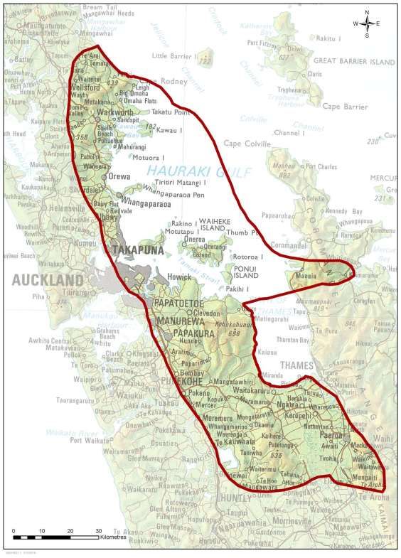
3 Te Tapuwae o Ngāti Paoa: The Footprint of Ngāti Paoa
Figure 1: Te Tapuwae o Ngāti Paoa
112322
Note: This map is not intended to identify exclusive claim, rather, to illustrate the area where
Ngāti Paoa considers that interests exist.
The Ngāti Paoa tribal rohe can be divided into five takiwā (districts/area) as follows:
• Mahurangi – from Te Ārai to Maungauika / North Head;
• Kohimarama – from Te Mata to Tāmaki River;
• Tāmaki – from the Tāmaki River to Wairoa River;
• Wharekawa – from Wairoa River to Pūkorokoro; and
• Hauraki Gulf Islands – including the islands in the Gulf.
More specifically for Ngāti Paoa, the following tribal traditional ‘pepeha’ illustrates the
boundary settlement as:
Ko te pou ki mua ko Te Hoe o Tainui,
Ko te pou ki tua ko Kawau, Ko te pou ki waho ko Waiheke, ko te pou ki uta ko Mokoia,
Ko Whakatīwai te poutokomanawa,
Ko Paoa te poutangata.
The foremost pillar is Te Hoe o Tainui,
The distant pillar is Kawau, The outer pillar is Waiheke, The inner pillar is Mokoia,
Whakatiwai is the pillar of the heart,
Paoa is the pillar for his descendants.
The general historical and cultural associations of Ngāti Paoa within Tāmaki Makaurau and
the Hauraki Gulf are well documented. The story of Ngāti Paoa has its origins in Tainui history
when Te Arawa chief Pikiao travelled to Pirongia and married Rereiao from Waikato. They had
a son called Hekemaru who later married Heke-i-te-rangi. The children of the Hekemaru and
Heke-i-te-rangi were a girl Paretāhuri, and two boys, Mahuta and Paoa. Paoa married
Tauhākari of the Ngā Iwi (a descendant of the Tini o Maruiwi, the ancient people of Peretū) at
Kaitotehe and their children were two sons named Toawhano and Toapoto, as well as Koura,
their daughter (Ngāti Koura being a senior sub tribe of the Tainui confederation of tribes).
In approximately the 1600s, Paoa left his home at Taupiri on the Waikato River, his wife
Tauhākari and their children. Paoa took another wife named Rauhea from Te Hoe o Tainui. He
later travelled to Piako, Hauraki. In Hauraki he married Tukutuku, the great grand-daughter of
Marutūahu, eponymous ancestor of the Hauraki tribes and the granddaughter of Tamaterā12.
Together they had 10 children. In the course of time the 10 children of Paoa and his followers
dominated the western shores of the Tikapa Moana o Hauraki ‘Hauraki Gulf’ the Hauraki
Plains and Piako River area from Kerepehi to Tāhuna, Te Hoe o Tainui, Pātetonga,
Waitakaruru, Pūkorokoro, Hauarahi, Kaiaua, Whakatiwai, Hunua, Orere and Clevedon. They
12
Simmons, D (2013) Greater Maori Auckland: Including the Maori Place Names of Auckland Collected by George Graham; Auckland,
The Bush Press of New Zealand. Page 45; and Graham, G (1951) The Journal of Polynesian Society, Tainui v60 no1 p80-92. Retrieved
from: http://www.jps.auckland.ac.nz page 82
122323
lived close to the related tribes of the Marutūahu compāct: Ngāti Maru, Ngāti Tamaterā,
Ngāti Whanaunga and those earlier tribes absorbed by them, Ngāti Huarere and Ngāti Hei.
As hapū of Ngāti Paoa took shape they built huge waka tauā and extended their footprint to
the Tāmaki River – Te Wai o Taiki, Kohimarama, Waitematā, Te Haukapua and Kiritai on the
North Shore. From their many pā Ngāti Paoa moved throughout the islands of Waiheke,
Pōnui, Rātōroa, Pākatoa and the wider islands of Tikapa Moana o Hauraki to Mahurangi, “Ngā
Poito o te Kupenga a Taramainuku”, the floats of the net of Taramainuku.13 Soon Ngāti Paoa
exerted an influence northwards until, by the 1700s, they held to a corridor from the
Waitematā Harbour south along the western shores of Tikapa Moana o Hauraki to the
Hauraki Plains.
Ngāti Paoa acknowledges our hapū, to Ngāti Hura, Ngāti Kapu, Te Uri Karaka and Te
Pātukirikiri. Ngāti Paoa also includes but not limited to:
1. Paoa O Wharekaho:
2. Ati Taheke:
3. Ngāti Horowhenua:
4. Matekiwaho:
5. Ngai Tauaiwi:
6. Ngāti Huia:
7. Ngāti Hura:
8. Ngāti Huruhuru:
9. Ngāti Kaiwhakapae:
10. Ngāti Kapu:
11. Ngāti Kauahi:
12. Ngāti Koura:
13. Ngāti Kupenga:
14. Ngāti Mahia:
15. Ngāti Manawa:
16. Ngāti Manu Aute:
17. Ngāti Ngāmuri:
18. Ngāti Omakau:
19. Ngāti Parengaherehere/Pare:
20. Ngāti Paretipa:
21. Ngāti Piri:
22. Ngāti Pōkai:
23. Ngāti Putoa:
24. Ngāti Raukura:
25. Ngāti Rauhea/Rauwhea:
26. Ngāti Rerekau:
27. Ngāti Ringatahi:
28. Ngāti Rurangi:
29. Ngāti Te Aho:
30. Ngāti Te Awa:
31. Ngāti Te Hiko:
32. Ngāti Te Umu:
13
Monin, P (2001) This Is My Place: Hauraki Contested, 1769 – 1875, Wellington, Bridget Williams Books.
132324
33. Ngāti Taharoku:
34. Ngāti Tahuna:
35. Ngāti Tarao:
36. Ngāti Taukiri:
37. Ngāti Taurua:
38. Ngāti Tipa:
39. Ngāti Tuahuru:
40. Ngāti Tuwhanga:
41. Ngāti Waitarata:
42. Ngāti Whata:
43. Te Aho Mate ki Tātahi:
44. Te Hingawaka:
45. Te Huruhuru:
46. Te Iwitanupo:
47. Te Korohura:
48. Te Kupenga:
49. Te Mate Tokorua:
50. Te Rapupō:
51. Te Taharoku:
52. Te Uri Karaka:
53. Te Uri a Haupa:
54. Tahakoko:
55. Upokotoia;
56. Waihinu;
Today the tribal centres of Ngāti Paoa are based around three marae; Wharekawa Marae at
Kaiaua by the western shores of Tikapa Moana, Makomako Marae at Pūkorokoro near
Miranda and inland at Waiti Marae, Tāhuna. Ngāti Paoa are also tangata whenua at Piritahi
Marae, Te Huruhi, Waiheke and today still enjoy close associations with the whānau of the
Marae who continue to uphold the Mana whenua status that is Ngāti Paoa.
142325
4 He Take Tō Ngāti Paoa ki te Whenua Kura Nei me te moana – The
Relationship of Ngāti Paoa to the land and sea
This section sets out the associations and relationship of Ngāti Paoa to the traditional cultural
landscape of Te Waitematā and Tikapa Moana o Hauraki, Te Onewa Pā (and areas north) and
Te Tō Pā (and areas in central). It presents our account of key events within the area that
shaped our tikanga and history, identifies who we have descended from, who we are, and our
connections to further afield within Aotearoa.
The history that is documented below is critical in shaping how we view the area in the
present day, regardless of whether works are taking place in areas that have been subject to
development over the years or not. This is because over time, our connections to the land,
and the events that have taken place there, have not changed.
4.1 Migration, War and Peace
Overview
Te Waitematā is a significant water way which Ngāti Paoa entered and occupied land on
either side of the isthmus at varying times of their migration, with fortified pā at Te To
(Freemans Bay) Panmure (Mokoia and Mauinaina), Te Onewa Pā (Northcote Point) and
Takapuna (North Head). As the name details “Tāmaki-Makaurau” – the land desired by many
– there was often tribal warfare. Accordingly the values connected with these processes and
events are related to whakapapa, life, death, and union.
Two key ancestral waka (Tainui and Te Arawa) to which Ngāti Paoa whakapapa, landed at
Waiheke following their significant journey from Hawai’iki. They left their markers on the
landscape, places where many important events were to occur over the course of Māori
occupation of Waiheke and surrounding Te Waitematā. The influence of the landings of the
ancestral waka, the occupation, warfare and battles that followed and the period of Ngāti
Paoa dominance on Waiheke tie Ngāti Paoa very closely to Waiheke.
The narratives outlined in this section are only chapters of the history of Ngāti Paoa. Many
other significant events led up to the narratives we have retold. Many others were happening
simultaneously. Many more followed.
Migration
Ngāti Paoa acknowledges the history of the island and its inhabitant’s pre, concurrent and
post their occupation and settlement. Ngāti Paoa acknowledges the first settlers, Maruiwi
from the Pacific, who arrived c950 and named Waiheke island Te-Motu-Arai-Roa ‘the long
sheltering island’. Tauhākari, the first wife of Paoa, was a descendent of Tini o Maruiwi,
thereby establishing the Ngāti Paoa link with Peretū and the region. Although, this link is
shared only by the descendants of the children of Paoa and his first wife Tauhākari. Toi-Te-
Huatahi ‘Toi the navigator’ arrived later in approximately the 1150's.
The stronger connection of Ngāti Paoa to Waiheke begins later around the 1350s, when the
Arawa waka landed at the Pūtiki inlet for rest and repairs following their arduous journey
from Hawai’iki. The awa and surrounding area is named Te Rangihoua meaning ‘the day of
renewal’ which relates to the relashing of their waka. The maunga where they landed was
named Te-Pūtiki-o-Kahumatamomoe ‘the top knot of Kahumatamomoe’. Kahumatamomoe
152326
was the son of the Arawa chief and ancestor, Tamatekapua. Once repairs were complete the
Arawa waka continued to Maketu.
The Tainui waka arrived at Waiheke around the same time, accompanied by the taniwha,
Moko-ika-hiku-waru, ‘the great eight tailed serpent fish’. On the Tainui waka at Horuhoru,
Gannet Rock, they heard the water lapping on the rocks. This reminded them of their
departure from Hawai’iki, and their lamenting gave rise to the names Tikapa Moana o Hauraki
(for the Hauraki Gulf), and Horuhoru/ Hotuhotu – which means heartfelt and uncontrollable
sobbing. Horuhoru is vested in Ngāti Paoa, recognising the connection to the place. The Tainui
waka continued with its descendants to return approximately 300 years later.
Figure 2.
Source: Journal of Polynesian Society, Tainui V60 1951 – illustrating the journey of Tainui from Hauraki to Waitematā
This map illustrates the journey of Tainui from Hauraki to Waitematā and identifies the Māori
place names across Tāmaki Makaurau. In particular, Te Hau Kapua the rangatira of Tainui
canoe landed at Te Hau Kapua (Torpedo Bay).14
In summary, Ngāti Paoa whakapapa to the ancestral waka of both Tainui and Te Arawa
through the marriages of the Te Arawa chief Pikiao to Rereiao from Waikato, the
grandparents of Paoa. Paoa is the eponymous ancestor of Ngāti Paoa.
14
Auckland Regional Council, (1996) Whakanewha Regional Park Management Plan, History of Human Occupation and Archaeology.
Auckland, New Zealand: Murdoch, G. Retrieved from: http://www.wmbc.co.nz/wp-content/uploads/2012/08/History-of-human-
occupation-and-archaeology-of-Whakenewha-Regional-Park2.pdfhttp://www.wmbc.co.nz/wp-content/uploads/2012/08/History-of-
human-%09occupation-and-archaeology-of-Whakenewha-Regional-Park2.pdf
162327
War and Peace
Warfare was frequent in the history of Māori occupation of Hauraki.15 Te Onewa Pā like
many other pā strategically located in Tāmaki Makaurau was invaded on a multitude of
occasions, and therefore the occupation of any iwi was likely to be challenged.
The Marutūahu (Hauraki) Confederation of tribes consisting of Ngāti Tamaterā, Ngāti Maru,
Ngāti Whanaunga and Ngāti Paoa were challenging and extinguishing the mana whenua of
Ngāti Huarere (Te Arawa) elsewhere on Waiheke and throughout the Coromandel Peninsula.
Taking place was the transition of Hauraki from the domain of Te Arawa to Tainui.16 This
movement from the Waikato began with Hotunui and later his son Marutūahu, descendants
of Hoturoa of the Tainui canoe after about 1650.
Ngāti Paoa hapū (sub-tribes), Te Uri Karaka, Ngāti Kapu and Ngāti Hura dwelled at Waiheke
after expanding from their traditional base lands of the Central East Waikato and the Western
Firth of Thames around the early 18th Century. These hapū of Ngāti Paoa also expanded in to
Tāmaki Makaurau and along the North Shore Coast Line as far as Mahurangi. Refer Figure 1.
As noted earlier, Ngāti Paoa links to Waiheke were established prior to invasion, through the
arrival of both genealogical waka, Te Arawa and Tainui at the island. It is not considered there
is a need to expand further on this history in this report.
In about 1740 the northern extension of Ngāti Paoa was restrained by the movement south of
Ngāti Whātua. Battles were fought on the Tāmaki isthmus and Ngāti Paoa was obliged to shift
over, to the eastern side of Tāmaki Makaurau and to the islands of Tikapa Moana. Then peace
with Ngāti Whātua was compacted by marriage settlements and gifts. The northern Ngāpuhi
followed close on the heels of the Ngāti Whātua in the later 1700s to challenge the
Waitematā holdings of both Ngāti Paoa and Ngāti Whātua. Following a complicated history of
attack and counter-attack, Ngāti Paoa held firm. Their famous fighting waka, Kahumauroa and
Te Kotūiti, and the strategic buttress of Te-Pūtiki-o-Kahumatamomoe Pā, maintained their
coastal prowess. Ngāpuhi captured O-Kahu-iti Pā at Waiheke, but not Te-Pūtiki-O-
Kahumatamomoe Pā.17
‘Ngāti Paoa were the most explosive of the Hauraki tribes in that by being mainly sea going
they adopted a mobility of action and ferocity that became the hallmark of their
performances.’ Tūroa (2000:69)
In the seventeenth century, Ngāti Paoa conquered Onewa and some other pā on the North
Shore and in West Auckland, but was defeated by Ngāti Whātua.18
Ngāti Paoa had an enviable agricultural economy to sustain their people. Captain Cook’s
description of the Firth of Thames attracted a great number of ships to the area. The period
1790–95 was dominated by sealing and whaling ships that did most of their repairs at
15
Waitangi Tribunal, Department of Justice, New Zealand (1987) Report of the Waitangi Tribunal on the Waiheke Claim (Wai10).
Retrieved from: http://www.justice.govt.nz/tribunals/waitangi-tribunal/publications/bound-reports. Page 3.
16
Simmons, D (2013) Greater Maori Auckland: Including the Maori Place Names of Auckland Collected by George Graham; Auckland,
The Bush Press of New Zealand. Page 45; and Graham, G (1951) The Journal of Polynesian Society, Tainui v60 no1 p80-92. Retrieved
from: http://www.jps.auckland.ac.nz page 82.
17
Waitangi Tribunal, Department of Justice, New Zealand (1987) Report of the Waitangi Tribunal on the Waiheke Claim (Wai10).
Retrieved from: http://www.justice.govt.nz/tribunals/waitangi-tribunal/publications/bound-reports
18
Simmons, D (2013) Greater Maori Auckland: Including the Maori Place Names of Auckland Collected by George Graham; Auckland,
The Bush Press of New Zealand. Page 45, and Graham, G (1951) The Journal of Polynesian Society, Tainui v60 no1 p80-92. Retrieved
from: http://www.jps.auckland.ac.nz Page 82
172328
Waiheke, which at the time, was the domain of Ngāti Paoa.19 This wealthy tribe was on the
brink of a new type of warfare. Ngāpuhi had a list of scores it wanted to settle. Hongi Hika had
recently returned from England and Australia with guns and a plan.
Around 1790, Ngāti Paoa fought a major battle at what is now Narrow Neck, and successful for
the moment Ngāti Paoa fortified Takapuna (North Head). The mooring place of the Tainui canoe
(Te Hau Kapua) is the same place where Ngāti Paoa ambushed Ngāpuhi canoes in 181920. In
1819 Ngāti Paoa escaped to Waiheke when they were besieged at the pā.21
In 1821 some 2,000 well-armed Ngāpuhi warriors set off from the Bay of Islands. In the
holocaust that followed, the Ngāti Paoa on Tāmaki (including the North Shore) were routed
and dreadful massacres took place. Some records indicating the loss of 300 Ngāti Paoa men 22,
and others indicating from the sight of the remains between 1000 – 2000 people of the battle
of Mauinaina and Mokoia.23 It appears that soon after the invaders challenged Waiheke,
which for 60 years had thwarted their pretensions. Te-Pūtiki-o-Kahumatamomoe Pā fell. The
defenders at Waiheke were no match for the musket and soon fled down the Firth of Thames.
They had not the expected opportunity to regroup and counter-attack. The beach near Kaiaua
remains sacred to this day for there some of the finest of the Ngāti Paoa fighting force were
overtaken in pursuit, and slain.24
The Ngāti Paoa survivors of these battles fled south to receive refuge with the Waikato tribes.
Long and tangled stories of raid and counter-raid continued well into the 1820s. It is sufficient
to say the invaders sought revenge and glory rather than land so eventually Ngāti Paoa were
able to return to their homes.
With the aid of a peace pact between Ngāpuhi and Te Rauroha of Ngāti Paoa, some of Ngāti
Paoa returned to their villages skirting Tikapa Moana. An account of this is retold by Maihi
(son of Maihi Te Hinaki and Riria from Ngāti Paoa) all of who survived the attack at Mokoia
and Mauinaina, following refuge in other areas of Tāmaki they returned to Waitematā in 1830
and lived at Awataha (Shoal Bay) and later there at Waiwharariki. They lived there at the
same time as the Ngāpuhi Chief, Eruera Patuone, and later moved with Patuone and a Ngāti
Paoa chieftainess, Riria Takarangi (a relative of Maihi’s mother Riria) who married Patuone, in
a peace arrangement. Patuone lived at Rangi on Ngāti Paoa land at Devonport in at least the
1840s. The land for the kāinga of Ngāti Paoa’s Te Rangi, to the north west of Mount Victoria,
was granted to him in 1854 and sold in 186025. Apparently he was given land as a protection
mechanism against his own people, Ngāpuhi26.
Ngāti Paoa (among many other iwi groups) was involved in the sale of land to Governor
Hobson in 1841, which formed part of the complete 1884 Crown purchase of the Mahurangi
Block – from Devonport to Te Arai. The whole purchase price was equivalent to £1500 in cash.
19
Verran, D (unknown) Maori at Te Onewa and Northcote to 1926, George Samuel Graham and the History of Onewa. Page 2.
20
Walker, R (2004 revised edition) Ka Whawhai Tonu Matou – Struggle Without End; Auckland, Penguin Books. Page 82.
21
Smith, S. P (1900) Journal of Polynesian Society, Volume 9, No. 1, Wars of the northern against the southern tribes of New Zealand
in the nineteenth century: Part III, Page 29.
22
Waitangi Tribunal, Department of Justice, New Zealand (1987) Report of the Waitangi Tribunal on the Waiheke Claim (Wai10).
Retrieved from: http://www.justice.govt.nz/tribunals/waitangi-tribunal/publications/bound-reports
23
Verran, D (unknown) Maori at Te Onewa and Northcote to 1926, George Samuel Graham and the History of Onewa.
24
Christmas, J (1981) Northcote: A background history; Auckland, Tanner-Couch Ltd.
25
Ibid.
26
Graham, G (1951) The Journal of Polynesian Society, Tainui v60 no1 p80-92. Retrieved from: http://www.jps.auckland.ac.nz
Pages 91-92
182329
From this time on, as settlers began to reside in the area, Māori names of the area started to
disappear27.
Patuone and Riria eventually moved to Te-Pūtiki-o-Kahumatamomoe Pā, Waiheke28.
Following the signing of Te Tiriti o Waitangi, the Government feared that the Māori living on
the outlying islands could pose a threat to the development of Tāmaki. Accordingly, in the
1840s, the constabulary forcibly removed Māori from Waiheke. Some resettled in the
Thames–Coromandel area and there they had to restart and rebuild a heritage for
themselves. By the 1950s, nearly all Ngāti Paoa had left Waiheke. Only archaeological sites
remain to evidence the relatively dense native population of past years.
Nonetheless, Ngāti Paoa descendants continued to be buried at Waiheke and specifically Te-
Pūtiki-o-Kahumatamomoe when they died, indicating that Ngāti Paoa still saw the island and
Te Rangihoua, as their ancestral home.
4.2 Cultural connections within the vicinity of the project
This section provides some detail of the cultural connections Ngāti Paoa have within the
landscape (and need to be considered within the realm of Te Ao Māori), such as: vantage
points from particular pā; settlements; significant events; food sources. These connections
have natural physical characteristics that have living significance to Ngāti Paoa and as such
have spiritual and cultural values, as well as aesthetic ones.
Fortress upon fortress had been built, developed and maintained as strongholds throughout
the rohe by Ngāti Paoa, rangatira and their hapū to protect the vast hinterland, motu and
food bowl of our people.29
This is not to be read as an exhaustive list of cultural connections, but a beginning to the
discussion of values to Ngāti Paoa.
Te Matā and Te Waitematā
Te Matā is the rock just to the south west of Kauri Point/Te Matarae o Mana (to the west of
Te Onewa Pā). This is a significant landmark as it was the Te Arawa under Tama Te Kapua
(chief and ancestor) who gave Tāmaki his mauri or soul by placing or burying a sacred rock
from Hawai’iki on Te Matā. The mauri or life source brought by Te Arawa canoe are
considered to give fertility to the gardens. The mauri was called Te Matā and so the water
was called Wai-te-matā, the waters of Matā. Another meaning is that Matā also means
obsidian, and the harbour at times glints like obsidian. This is also referred to as boat rock or
Niho Kiore/Rat’s Tooth.30 Te Matā was a place of uruuruwhenua, a ceremonial place. 31 A
party of Ngāti Paoa were attacked at Kauri Point while out fishing and the survivors were tied
to the rock. This rock was considered tapu as the Te Arawa waka and their crew are recorded
27
Andrews, K & Gray, D, (2010) Ngāti Paoa Cultural and Heritage Assessment of the ARC Waitawa Regional Park and Pawhetau Pa.
28
Simmons, D (2013) Greater Maori Auckland: Including the Maori Place Names of Auckland Collected by George Graham; Auckland,
The Bush Press of New Zealand. Pages 38 and 77.
29
Harlow, Diane (2011), Chelsea Estate Heritage Park Conservation Plan; Architage on behalf of Auckland Council Parks Department.
Section 3, page 11.
30
Christmas, J (1981) Northcote: A background history; Auckland, Tanner-Couch Ltd. Page 8.
31
Verran, D (2010) The Northshore: An illustrated history. Auckland, Random House New Zealand. Page 14.
192330
as having carried out their customary traditions of Uruuruwhenua at this location. The
survivors of the attack were then left to perish as the tide began to rise. This particular
incident became known as Niho Kiore and Ngāti Paoa imposed a rāhui around the location
and later claimed the rock as a boundary marker, and the surrounding waters as their own.
AREAS TO THE NORTH OF TE WAITEMATᾹ
Te Onewa Pā
The land to the north of Te Waitematā (where the Auckland Harbour Bridge is connected) is
referred to as Te Onewa Pā. The name Te Onewa Pā, is either based on its ditch defense
system on this southern cliff (“divided earth”), or in relation to the dark grey basaltic rock that
was found near here and a club made from this (“pātu onewa”)32. The pā protected kainga
(unfortified settlements), whose inhabitants relied on local roots and berries, kumara
cultivation and nearby fishing grounds – which included shark, sea-fish, shellfish - cockles,
pipis, mussels; sea eggs, and fresh water eels from lake Pupuke and Wairau creek33.
This site was popular among many tribes, and is thought to have been in use for hundreds of
years. It was a strategic site with expansive views of Te Waitematā and the whole of the
North Shore34. This would have also contributed to it being a location of inter-tribal conflict35.
The beach area to the west of this area is called Onepoto, aka little Shoal Bay. Okawau was
the home of the shag at the southern-most tip.36
Totara-tahi (one Totara tree)
In 1908 the point was called Totara-tahi (one Totara tree), which is associated with the
planting of a Totara tree called “Tainui” after the original canoe. The tree planting was
associated with the new status as a borough (Northcote Borough) and involved an important
presentation ceremony with Pataka Hapi of Waikato (see photos Appendix 2) who lead with
the history on the area and a haka37. The ceremony included the installation of a 4.5m flag
(ensign) and a 23m flagpole which Māori contributed funds to. It was at this time (unknown
whether prior to the ceremony or following) that the council made Te Onewa Pā (aka Point
Rough, Stokes Point and at this time referred to by Pākeha as Northcote Point) a public
domain. Several tall trees on this site were planted, but felled due to construction of the
Auckland Harbour Bridge38.
32
Christmas, J (1981) Northcote: A background history; Auckland, Tanner-Couch Ltd. Page 8.
33
Verran, D (unknown) Maori at Te Onewa and Northcote to 1926, George Samuel Graham and the History of Onewa.
34
Christmas, J (1981) Northcote: A background history; Auckland, Tanner-Couch Ltd.
35
Verran, D (unknown) Maori at Te Onewa and Northcote to 1926, George Samuel Graham and the History of Onewa; and
Christmas, J (1981) Northcote: A background history; Auckland, Tanner-Couch Ltd. Page 21.
36
Verran, D (unknown) Maori at Te Onewa and Northcote to 1926, George Samuel Graham and the History of Onewa; and
Christmas, J (1981) Northcote: A background history; Auckland, Tanner-Couch Ltd. Page 41.
37
Simmons, D (2013) Greater Maori Auckland: Including the Maori Place Names of Auckland Collected by George Graham; Auckland,
The Bush Press of New Zealand. Page 69.
38
Christmas, J (1981) Northcote: A background history; Auckland, Tanner-Couch Ltd. Page 41.
202331
Te Kopua o Matakerepo and Te Kopua o Matakamokamo
These are two volcanoes located on the north shore (see map in Appendix 3 with
accompanying Māori place names). It is considered the volcano god, Mataaho, stepped from
these two lagoons (Ngā Tapuwae) at Barry’s Point Road, right across the isthmus to the lake
of Te Pūkaki Tapu o Poutukeka, south of the airport.39 In essence they mean, the food
bowls/basins of Matakerepo (located to the south) and Matakamokamo (located to the
north).
Te Kopua o Matakerepo was a basin (aka Onepoto Basin or Onepoto Domain) that was
originally an area that was waterlogged and open to the sea, but is now enclosed and filled
with earth/hard material from the construction of the Auckland Harbour Bridge 40.
Awataha
Awataha is an important site to Māori. It is also known as area of land near The Warehouse
Way in Akoranga on the north side of the Tuff Crater at Northcote (Matakamokamo), which
was part of the Awataha village (papakāinga) and close to where Awataha marae and AUT
Akoranga are situated today. The channel that ran through Barry’s Point Reserve (originally
mudflats and tidal channels, reclaimed during 1930-1979, and cleanfill in 1980s) and Hillside
Creek is known as Awataha.41
There was an important site at Awataha – Te Urupā. In 1911 it was estimated there were
around 69 men, women and children; some of them were important kaumatua and kuia,
mainly Hauraki, who were later buried at Awataha urupā. This included Noka Hukanui and his
wife Waiti Noka42. Around 1910-16 Māori claim the area was an ancestral site and was never
intended to be part of the Mahurangi land purchase. The Crown did not agree, but this did
not deter Māori between 1925-26 from asserting the value of the land to them – although
they were issued with trespassing notices; time in prison; removal of remaining dwellings;
and then subsequent removal of tents43. Eventually those who were residing here, returned
to other areas of land close by, and/or of value to them.
Awataha remained vacant until 1942 when Ngāti Paoa tūpuna were disinterred (from the
urupa) to make way for a fuel-oil storage depot for the United States Navy. Both Ngāti Paoa
and Tainui, were asked by the Public Works and Health Department as it was required for
“war purposes”, to remove their tūpuna/ ko iwi (graves) in secret.44
Here is a poem from Hone Tuwhare written 20 years after the event:
Burial
In a splendid sheath
of polished wood and glass
with shiny appurtenances
lay he fitly blue-knuckled
and serene:
39
Northshore City Council (2006) Reserve Management Plan – Barry’s Point Reserve. Page 20-21.
40
Verran, D (2010) The Northshore: An illustrated history. Auckland, Random House New Zealand. Pages 24-26.
41
Ibid.
42
Ibid, and http://www.awataha.co.nz
43
http://www.awataha.co.nz
44
Ibid.
212332
hurry rain and trail him
to the bottom of the grave
Flowers beyond budding
will not soften the gavel’s
beat of solemn words
and hard sod thudding:
hurry rain and trail him
to the bottom of the grave
Through a broken window
inanely looks he up;
his face glass-gouged and bloodless
his mouth engorging clay
for all the world uncaring…
Cover him quickly earth!
Let the inexorable seep of rain
finger his greening bones, deftly
Hone Tuwhare summarises the poem as follows:
“My poem details the aftermath when we hauled Puhata from the womb of the
earth in a kind of Caesarean operation. My poem, which finally emerged about
twenty years after the event (the disinterment) and was first published in 1960,
is in essence a poem of extreme repugnance for the insensitivities of Pakeha
institution in heaping that kind of indignity Waikato: for nothing came of it, after
all, and no tanks (oil) were ever sited there”.45
Hone Tuwhare said “the whole incident became a burden which weighed heavily on me for
many years. It was like an albatross on my back”. The Māori people were angry and upset at
having the burial place of their ancestors desecrated and, to add insult to injury were forced
to keep the whole thing a secret46.
This site was significantly altered with 153,000m3 of excavations and 18m diameter concrete
foundations laid for 25 fuel-oil tanks. The site was no longer required a year later for defence
purposes, and the remaining areas were subsequently utilised for motorway purposes, and
later for commercial, residential and educational purposes – AUT47.
Although compensation does not protect the values of an area to Māori, it is important to
understand the context at this time and the disparities to Māori, whereby under the former
Public Works Act there was no requirement for compensation to Māori for taking of land –
despite Pakeha being compensated. This was changed in 1927 to include compensation for
Māori land, but customary land was not included until 197448.
45
Verran, D (2010) The Northshore: An illustrated history. Auckland, Random House New Zealand. Page 25
46
Waitangi Tribunal, Department of Justice, New Zealand (2006) Report of the Waitangi Tribunal on the Hauraki (Wai 686).
Retrieved from: http://www.justice.govt.nz/tribunals/waitangi-tribunal/publications/bound-reports. Volume 3 pages 1053-1057.
47
Simmons, D (2013) Greater Maori Auckland: Including the Maori Place Names of Auckland Collected by George Graham; Auckland,
The Bush Press of New Zealand. Pages 10 and 36.
48
Graham, G (1951) The Journal of Polynesian Society, Tainui v60 no1 p80-92. Retrieved from: http://www.jps.auckland.ac.nz Page
82
222333
Pupuke Moana - Lake Pupuke
In the 1200 C.E when the sleeping fires of Tāmaki awoke and came forth Rangitoto, the god of
volcanoes being, Mataaho who resides at Te Ipu a Mataaho - the crater of Maungawhau (Mt
Eden)49… there are a few stories associated with the origins and naming of Rangitoto (Te
Rangitoto o Tamatekapua – tapu by Tainui and Te Arawa50), one story on its origins in
particular, physically links it to the land area of Pupuke:
It is said that Rona, a lay of the district, was intent on some weaving. The light of the
day went as the sun went down, leaving Rona unable to finish her work. She was
annoyed by the curse of Mahuika, goddess of fire, for not giving her light to finish.
Mahuika had not even been asked, so was very annoyed at being cursed by this
impudent lady. She reached down and grabbed the hill Rona was sitting on from
below, drew it down then thrust it up again as the hill we now know as Rangitoto.
Rona herself threw into the sky, weaving and all. She is still there as the lady in the
moon grasping her bundle of weaving…Lake Pupuke which fills the hole left by
Rangitoto…is named Pupuke Moana because it breathes, or rather overflows51.
This site was also a significant fresh water source.
AREAS TO THE SOUTH OF TE WAITEMATᾹ
Te To pā – Headland Pā at Freemans Bay
Te To was a headland Pā at Freemans Bay, that was mostly removed to provide fill for the
reclamation of Freemans Bay which began in the 1870s and was completed by 1901 (now the
ground surface of Victoria Park).52 This pā was a significant defensive position. Both this pā
and Te Oka pā (see below) were considered to be out of the firing line for raiders in swift
canoes.53
Waikokota (shellfish waters) describes the shallows of Freemans Bay with abundant shellfish.
Waiatarau (reflections) the contemplative waters, perhaps viewed from the pa above, the
shallow tidal movements of the bay under shifting light (moon).54 The new public space/plaza
area in front of the Bird Cage Tavern (part of the Victoria Tunnel project) has been named
Waiatarau to represent/identify this cultural landscape in the present day.
Figure 3 below, illustrates the original foreshore line (based on high water mark in 1840) and
the tidal area 80m from this land. It also indicates five cultural areas/events/markers (as
referenced by George Farrant of the heritage team at Auckland Council), including Te To Pā.
This map visually details some of the cultural values of the area more specifically than the
Proposed Auckland Unitary Plan historic heritage layer.
49
Simmons, D (2013) Greater Maori Auckland: Including the Maori Place Names of Auckland Collected by George Graham; Auckland,
The Bush Press of New Zealand. Pages 70-71.
50
Palmer, D (2002) Walking Historic Auckland; NZ, New Holland Publishers Ltd. Page 52
51
Turei, P (2006) Evidence for Notice of Requirement: Victoria Park Tunnel.
52
Ibid.
53
Simmons, D (2013) Greater Maori Auckland: Including the Maori Place Names of Auckland Collected by George Graham; Auckland,
The Bush Press of New Zealand. Pages p12-13.
54
Simmons, D (2013) Greater Maori Auckland: Including the Maori Place Names of Auckland Collected by George Graham; Auckland,
The Bush Press of New Zealand. Page 45; and Journal of Graham, G (1951) The Journal of Polynesian Society, Tainui v60 no1 p80-92.
Retrieved from: http://www.jps.auckland.ac.nz page 82
232334
Figure 3.
Source: Victoria Park Event Guideline approved by Waitematā Local Board March 2014 – Appendix 1.
Te Oka Pā – Point Erin and surrounds
Motu Ngaengae: Watchmans Island is an integral component of the mauri of the area.
Te Ōkā: Pt Erin Baths and surrounds was a former headland pā with kāinga spilling into the
sheltered valleys.
Te Oneroa o Huatau / Te Oneoneroa o Ureia: (Shelley Beach), the sands of Huatau / The long
beach of Ureia is the beach below the pā. An ideal Tauranga waka, launching waka site at all
tides. Neho Keepa of Ngāti Paoa recalled that the beach was known in the early 20 th Century
as ‘Tauranga Mango’ – landing place of sharks.
4.3 Natural Resources
Through the Mana whenua lens there is an intrinsic relationship that exists with the land. This
was a land that was not demarcated by western titles of ownership but by her ecological
features such as maunga, ridgelines, waterways, and sites of cultural and spiritual
significance.
242335
Paoa ki uta, Paoa ki tai
Ki Waiheke
Ki Maunganui
Ki Tikapa
Haere mai ki Hauraki
He aute tē āwhea
Ko Paoa te tangata
Sustenance of the people
Te Waitematā and the surrounding water areas had abundant seafood. The abundance of the
sharks near this area is recorded as some 9,000 shark were fished at Kauri Point (near Te
Onewa Pā), and Puponga Point (Manukau) for a feast to affirm alliances in 1844, where some
3000 Māori attended.55 There were also records of fish, cockles, mussels and pipi within the
project water areas. Archaeological evidence further supports this cultural reference as there
are recorded midden pits around sites, such as Matakerepo.
Prior to the Auckland Harbour Bridge construction and the reclamation both the extent of
Shoal Bay and Sulphur Beach and Freemans Bay, was much greater than what is present now.
The water areas around Pupuke Moana and the stream network flowing into Oneoneroa
would have provided fresh drinking water. This includes Takapuna, known as the rock with a
spring (to the south side of Te Hau Kapua). Tainui drank of the waters of Takapuna (named
after Te Kawerau chief) when they first landed at Torpedo Bay, so called by them in memory
of that drinking spring in their homeland at Hawai’iki. 56
It is understood that the land to the north around Te Onewa Pā would not have provided
much in the sense of food resource asides from fern root, due to its clay soils, whereas the
areas around volcanic formations would have provided fertile soil for kumara and other
crops. The Takapuna and Devonport area was covered in tea-tree and flax, whereas areas
around Birkenhead were densely covered in kauri trees.57
The coastal forest associated with the kauri would have provided Māori with a wide variety of
foods, medicines and building materials as well as attracting birds which provided a valuable
food source. Particularly noted were the fruits (ureure) and white fleshy bracts (tawhara) of
the male flowers of the kiekie (Freycinetia banksii), a forest delicacy abundant in the North
Shore gullies, and also the fruits of the maire tawake (Syzygium maire) found growing in
swampy situations in Birkenhead. 58
Wai Kuta: (Kuta stream near College Hill) – Kuta was a textile resource with water proof
qualities. This is no longer present as the stream has been piped. Tuna Mau (eel stream from
Western Park), eel resource area that most likely had wetlands59.
55
Fisher, M and Hilder W (1969) Birkenhead: The Kauri Suburb; Birkenhead Borough Council. Page 10.
56
Harlow, D (2011) Chelsea Estate Heritage Park Conservation Plan; Architage on behalf of Auckland Council Parks Department.
Section 3, page 12.
57
Turei, P (2006) Evidence for Notice of Requirement: Victoria Park Tunnel.
58
Walker, R (2004) Ka Whawhai Tonu Matou - Struggle without an end; Auckland, Penguin Books. Pages 87-97
59
Ibid.
25You can also read