Damming rivers in the tectonically resurgent Uttarakhand Himalaya
←
→
Page content transcription
If your browser does not render page correctly, please read the page content below
GENERAL ARTICLES
Damming rivers in the tectonically resurgent
Uttarakhand Himalaya
K. S. Valdiya
In the fault-ridden, seismically and tectonically active belts recurrently ravaged by excessive rains
and resultant landslides in Uttarakhand, a very large number of big and small dams are being con-
structed and planned. Quite many of these projects suffered crippling damages during the 2013 dis-
aster as mountain slopes slid down and floodwater severely eroded stream banks and dumped huge
volumes of sediments on critical facilities. If the idea is to have environment-friendly power projects,
then the planners and dam builders must not ignore the geological reality of the geodynamically
sensitive region. Better sites for dams can be explored far upstream of the Main Central Thrust Zone.
Keywords: Hydroelectric projects, dams, landslides, seismicity.
Ambitious plan serious problems, such as washing away of barrages and
coffer dams, onrush of water and finer sediments, blow-
T HE vision of making Uttarakhand an Urja Pradesh outs and roof-collapse in tunnels associated with the pro-
(energy state) has inspired the state of Uttarakhand to jects, accumulation of sediments in reservoirs behind
embark upon an ambitious plan of having more than 180 dams, malfunctioning or even stoppage of generator tur-
big and small hydroelectric projects that are expected to bines due to excessive discharge of sediments, etc. during
generate more than 21,200 MW electricity (12,235 MW high floods and resultant loss of their economically use-
from just 95 projects in the Alaknanda and Bhagirathi ful life. The spectacle of devastation of a number of pro-
valleys; The Pioneer, 4 July 2013). Most of these projects jects under construction was witnessed with stunning
are located in the upper and middle reaches of 11 rivers impact in mid-June 2013. This was to be anticipated, for
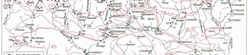
(Figure 1) (Patni, B. D., pers. commun., 2013)1,2. the projects are sited in the structurally disturbed and
From the structural map of Uttarakhand showing the tectonically over-stressed belt of seismicity, relentlessly
locations of dams and the terrane-defining thrusts and battered by excessive rainfalls and cloudbursts (Figure 2).
faults, it becomes obvious that presumably three factors
weighed heavily in the siting of these dams – (i) narrow- Belt of the Main Central Thrust
ness of the valleys, (ii) adequate water discharge in
rivers, and (iii) head of water requisite for turning tur- The ever-snowy mountain ranges rising to heights of
bines of generators. It is also quite apparent that the 5,000–8,000 m are known as the Great Himalaya or
structural layout (particularly related to faults and thrusts Himadri. It is made up of high-grade metamorphic rocks
in the areas chosen) and the seismicity of the region were intimately associated with mylonitized ( milled and
not taken into consideration. No thought was given to the recrystallized) porphyritic granites and augen gneisses. A
need for preserving the environmental integrity and to huge part of these rocks rides over the sedimentary and
the socio-economic problems the affected people will low-grade metamorphic rock assemblages of the Lesser
face or are facing. Himalaya – the populated terrane of Uttarakhand. The
Undeniably, the whole purpose of erecting dams is to southward thrusting of rock masses has taken place along
generate electricity. Storage of water for irrigation and a multiplicity of thrusts comprising the Main Central
control of floods were secondary, if at all. None of the Thrust (MCT) zone (Figures 2 and 3). The three impor-
planned dams in Uttarakhand can therefore be described tant thrusts of the MCT zone are the Munsiari Thrust at
as multi-purpose projects (Tables 1 and 2). Most of the the bottom, the Vaikrita Thrust in the middle and the Pin-
existing projects with installed capacity of nearly dari Thrust at the top1,3–6. A thrust never occurs alone; it
20,000 MW are not able to generate more than half their is always associated with parallel, sub-parallel thrusts
generating capacity (Patni, B. D., pers. commun., 2013). branching off from the main thrust. The result is the for-
Several dams and tunnels under construction are facing mation of imbricate piles of sheets and slabs of deformed
and sheared rocks (Figures 3 and 4). It may be empha-
K. S. Valdiya is in the Jawaharlal Nehru Centre for Advanced Scien-
tific Research, Bangalore 560 064, India.
sized that the Himalayan province is not only dissected
e-mail: ksvaldiya@gmail.com by ENE–WSW trending rather northward gently dipping
1658 CURRENT SCIENCE, VOL. 106, NO. 12, 25 JUNE 2014
GENERAL ARTICLES

Figure 1. Structural map of Uttarakhand showing locations of big dams (height >25 m) in existence, under construction and those planned. The
positions of dams are approximate. The structural elements comprise major thrusts and transverse (tear) fault dissecting the land. (Map after
Valdiya 1 and location of dams after Thakkar2 and Patni (pers. commun., 2013)).

                   Table 1.    Existing, under construction and proposed hydroelectric projects in Uttarakhand (after Thakkar2 )

                River                                        Existing        Under constriction      Proposed           Total

                Bhagirathi                                      13                   13                 22               48
                Alaknanda                                       32                   16                 74              122
                Mandakini and Pindar                             4                    2                                   6
                Ramganga                                        12                                      20               32
                Kali (including Gori and Darma)                 28                    8                 48               84
                Yamuna                                           9                    2                 33               44

Table 2.   Number of hydroelectric projects in Uttarakhand (after              As the northward-moving Peninsular India presses on,
                          Thakkar2 )                                        the Lesser Himalaya rock assemblages are compressed,
                                 Big           Small                        and are pushed under the huge pile of the Great Himala-
River                         (>25 MW)      (1–25 MW)           Total       yan rocks, the latter riding southwards onto and over the
                                                                            Lesser Himalaya.
Bhagirathi, Bhilangana           5               13               18
Alaknanda, W. Dhauli,           29               43               72           The movement has been going on since the MCT was
  Birahi, Pindar                                                            formed 20–22 million years ago. This movement is not
Ramganga                         6               12               18        continual but intermittent, rather episodic.
Kali, Darma, Gori               26               16               42           As a consequence of episodic movements on active
Yamuna                          17               13               30
                                                                            thrusts, there is compression and squeezing of the Lesser
                                                                            Himalayan rock assemblages, their bending and sliding
                                                                            along inter-formational thrust planes of the MCT zone.
thrusts, but is also torn by NW–SE, NNW–SSE, N–S and                        This has resulted in a number of thrust planes coming in
NNE–SSW trending nearly vertical dip–slip, net slip and                     closer proximity just south of the southern slopes of the
strike–slip faults, which have pronouncedly wrenched the                    Great Himalaya (Figures 1, 2 and 3). Another conse-
rock piles (Figure 1).                                                      quence of the repeated movement is shearing, shattering
CURRENT SCIENCE, VOL. 106, NO. 12, 25 JUNE 2014                                                                                         1659
GENERAL ARTICLES

Figure 2. The Main Central Thrust (MCT) zone in Uttarakhand comprising long, deep thrust planes, including the Munsiari Thrust, the Vaikrita
Thrust, and the Pindari Thrust. Besides these three principal thrust planes, there are a large number of thrusts and faults sub-parallel to or branching
from them; quite a few of them are active (after Valdiya et al.3 ).

                 Figure 3. Sections across the MCT zone in Uttarakhand Himalaya showing active thrust planes (thick line)
                 along the valleys of the Kali, Alaknanda and Mandakini rivers. Note how the Lesser Himalayan rock assemblages
                 slide under the Great Himalaya, even as the rock piles of the latter advance southwards over the former (Lesser
                 Himalayan assemblages) (after Valdiya 1,5).

and even pulverization of rocks, resulting in considerable                    Neotectonic activities
weakening of rocks. The weakened rocks are easily
vulnerable to seismic shocks, rains, frost action and to the                  Investigations carried out along the rivers Kali, Darma
imprudent activities of humans.                                               (Eastern Dhauli), Gori, Western Dhauli, Alaknanda,
1660                                                                                        CURRENT SCIENCE, VOL. 106, NO. 12, 25 JUNE 2014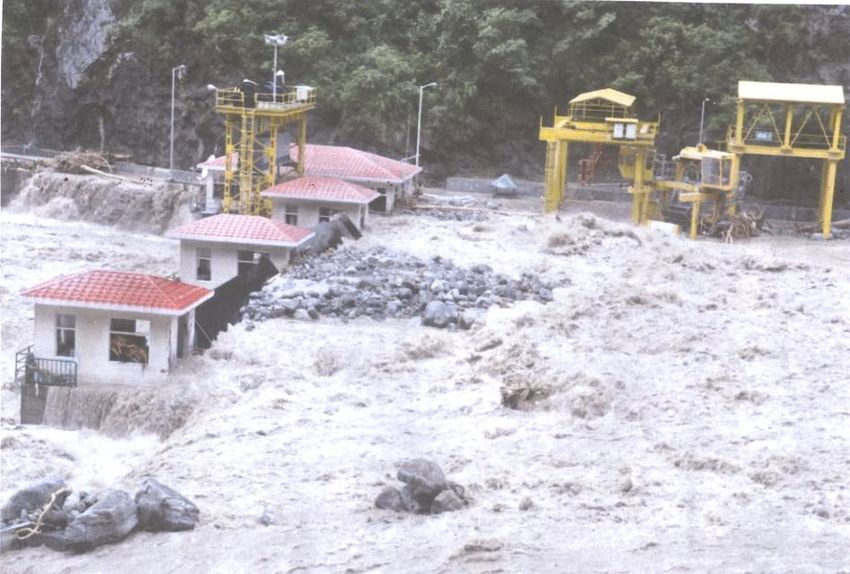
GENERAL ARTICLES

Mandakini and Bhagirathi demonstrate that practically all                Kali and Gori valleys in the east, imply continuing move-
thrusts of the MCT zone, and quite many of the Lesser                    ment at present on some of the faults of the MCT zone.
Himalayan terrane are neotectonically active. These have                 This is further borne out by occurrence of earthquakes all
been active in the Late Quaternary times, including the                  along the belt, just south of the Great Himalayan axis
Holocene. In other words, there were backward–forward,                   (Figure 5). Needless to state that earthquakes result from
sideways and up-and-down movements on them, particu-                     movements on planes of rupture which may or may not
larly since about 60,000 years4,6–13.                                    reach the surface.
   The Joshimath area (Figure 2) has been intermittently                    The metamorphic and granitic rocks of the Chhiplakot
sinking over a long belt for quite many decades owing to                 massif in eastern Kumaun have been rising up. The rock
the activeness of the Vaikrita Thrust that passes by.                    assemblages above the Vaikrita and Munsiari thrusts of
   The incidence of prolonged rock falls and slumping of                 the MCT zone are exhumed or pushed up at the rate of
rock-masses even during dry seasons witnessed in the                     1.2–3 mm/yr (ref. 14). Geodetic levelling and GPS inves-
                                                                         tigations demonstrate that the whole of the Lesser Hima-
                                                                         laya in Nepal is rising at the rate of ≤ 3 mm/yr, while the
                                                                         Great Himalaya is gaining height at the rate more than
                                                                         5 mm/yr (ref. 15). The rise of mountains is attributed to
                                                                         movements on active faults. Faster uplift together with
                                                                         environmental degradation has accelerated the rate of
                                                                         denudation – it is more than 6 mm/yr in a part of central
                                                                         Nepal16, and could be no less in the tectonically ravaged
                                                                         terrains of Uttarakhand. The inevitable consequence of
                                                                         voluminous accumulation of erosion-generated sediments
                                                                         is the progressive shallowing of channels, and frequent and
                                                                         more destructive floods. It happened this time around be-
                                                                         cause enormous volume of debris had been dumped in the
                                                                         river valleys by the builders of roads and dams. In a num-
                                                                         ber of reaches of rivers, the river beds rose by 10–20 m!
                                                                            The geomorphic peculiarity of the Himalaya bears elo-
                                                                         quent testimony to the continuing uplift of the land. In the
                                                                         Great Himalayan domain, river valleys are characterized
                                                                         by gorges with nearly vertical to convex walls and slit
                                                                         canyons in the proximity of active faults marked by pro-
Figure 4. The zone of imbricating pack of thrust sheets and slabs, re-   nounced knick points on river beds.
sulting from repeated and strong movements along the thrust planes of
the MCT. The hypocentres of the aftershocks of 1991 and 1999 earth-         In the Lesser Himalayan terrain, the commonly wider
quakes in Garhwal are related to the imbricate zone (after Kayal 17 ).   valleys with gentle valley slopes abruptly narrow down to
                                                                         canyons and gorges close to the active terrane-defining
                                                                         thrusts (Figure 6). These features imply faster uplift of

Figure 5. Distribution of epicentres is concentrated in the nearly
50 km wide belt of the MCT zone. Note, some areas register more fre-     Figure 6. Evolution of a gorge as the hill gradually rose due to
quent earthquakes (after Paul et al.22 ).                                movement on an active thrust plane.

CURRENT SCIENCE, VOL. 106, NO. 12, 25 JUNE 2014                                                                                     1661
GENERAL ARTICLES
rock masses on the planes of discontinuity (fault or the number of earthquakes of M 5, this part of the
thrust). Moreover, terraces lining these valleys represent Himalaya (Kapkot–Dharchula–Bajang) shows highest
sediments deposited by rivers as their bed gradient less- seismicity anywhere in the Himalaya. Myriads of micro-
ened due to uplift and/or resultant blockage (Figure 7). earthquakes occur in this region 21.
Thus, the narrow gorges and riverine terraces upstream of Analysis of 312 out of 2000-odd events of M 4.5 dur-
these gorges testify to the fact that there were upward ing the period 1999–2004 indicated that the strain accu-
movements on the active thrusts and faults in the not-too- mulated in the stressed rock masses of Uttarakhand is
distant geological past. Stepped terraces indicate more released by the NNW–SSE and N–S trending faults22,
than one spurt of uplift. Commonly there are three levels corroborating the inference of Valdiya 4,7.
of terraces, implying as many episodes of upward move-
ments on active faults and thrusts. In quite many areas Zones of endemic–recurrent landslides
there are more than three levels of terraces, indicating
repeated movements on thrusts. It has been stated that repeated movements on the
multiplicity of thrusts and faults have caused shearing,
shattering and breaking of rocks, which were already
Seismicity condition
mylonitized (milled and recrystallized) in the distant past.
The rocks making the southern slope of the Great Hima-
The MCT zone is seismically the most active belt of Utta-
laya and the adjoining mountain ranges of the Lesser Hi-
rakhand, where maximum strain build-up is taking place.
malaya are thus in a very weakened state, and therefore
Most of the epicentres of moderate earthquakes (M 5)
extremely vulnerable to seismic shocks and battering of
are concentrated in a narrow (50 km) zone (Figure 5).
rains. Even small tampering with the precarious balance,
Focal mechanisms demonstrate that most of the events
such as digging for house-building and quarrying can
are related to shallow ( 30 km) thrusting. The October
have adverse effect on the slope stability. Excavations
1991 Uttarkashi earthquake (Mb 6.6) and the March 1999
related to mining and road network have greatly destabi-
Chamoli earthquake (Mb 6.3) originated at a depth of
lized the slopes, triggering unending rock falls, landslides
12–15 km, and their aftershocks17 occurred all over the
and debris avalanches during heavy rains. Denuding the
imbrication zone of thrust sheets (Figure 4).
slopes of their protective forest cover has considerably
The 1999 Chamoli earthquake is related, in my opin-
aggravated the problem of hazard from mass-movements.
ion1,7, to the extremely active Nandprayag Fault. This
Pointing to the fact that there are a number of active
fault (Figures 1 and 2) generated aftershocks by strike–
faults, there is a high seismicity, and the landslides are
slip mechanism17. Soft-sediment deformation features in
frequent and large in dimension in the narrow MCT belt
the riverine sediments18 corroborate the inference that
(Figure 8), I had suggested complete banning of defores-
this area is recurrently affected by tectonic movement.
tation, mining and expansion of settlements, and mini-
Likewise, deformation of soft fluvial sediments in Uttar-
mum road-building activities in this extremely vulnerable
kashi area cut by a N–S trending Henna fault indicates
belt23.
that this whole Chamoli–Uttarkashi belt has been experi-
encing unbearable tectonic stresses19.
The Kapkot–Dharchula area and adjoining Darchula– Excessive rainfall and cloudbursts
Bajang area in NW Nepal are frequently rocked by earth-
quakes of M 5 to 6.5. From the quantitative seismicity To compound the tragedy resulting from frequent earth-
map of the Himalaya 20, it is apparent that if one goes by quakes and large-scale landslides, there has been exces-
sive rainfall, quite often extremely heavy rainfall over
limited geographic area at a time, for the last 7–8 years24.
The mid-2013 calamity that befell Uttarakhand demon-
strated the enormity of the hazard that stalks the land of
the MCT zone.
Locations of hydroelectric projects
Realizing that there is no adequate arable land and indus-
trial manufacturing base in the larger part of Uttarakhand,
only the hydroelectric potential provides the means to
Figure 7. Due to uplift on a fault/thrust plane and heaving up of the finance economic growth and social development as
ground, the gradient of the river bed decreases, causing deposition of seems to be happening in Bhutan. It is therefore necessary
its sedimentary load. Subsequent spurts of uplift are responsible for the
formation of many levels of terraces – the evolution of stepped ter- that the state harnesses its rivers for energy generation.
races. (Diagrammatic sketches after Valdiya 5 .) However, the sites must be chosen carefully taking into
1662 CURRENT SCIENCE, VOL. 106, NO. 12, 25 JUNE 2014GENERAL ARTICLES
Figure 8. The MCT zone, characterized by active thrusts, endemic landslides and recurrent earthquakes, is a belt of unstable
slopes vulnerable to seismic shocks, battering of rains and human activities (after Valdiya 23).
consideration the geological and ecological factors, inde- Reactivation of the active thrusts is bound to impact
pendent assessment of benefits to the local people and the stability of the engineering structures. One of the
the country at large and control on the management of the impacts could be the displacement or disruption of the
projects. structures due to sudden release of stress that the thrust
It will be obvious from the distribution of dam loca- movements entail. The effects on the tunnels associated
tions (Figure 1; Tables 3–6) based on information culled with dams would be far more severe – there would be dis-
from reports of Central Electricity Authority, Uttara- ruption or offsetting of tunnel, roof collapse, sudden on-
khand Hydroelectricity Nigam, Uttarakhand Renewable rush of interstitial groundwater with crushed material,
Energy Development Authority, etc. that the existing hy- and severe damage to tunnel lining. The very making of a
droelectric projects and those that are under construction tunnel is like opening an underground drainage and thus
or planned are sited close to the terrane-defining thrusts altering the groundwater regimes of the mountains,
known to be active. The sites were chosen presumably in resulting in drastic lowering of groundwater table and
the narrowest stretches of the river valleys, little realizing attendant drying up of springs and dwindling of surface
that the otherwise wide valleys with gentle valley sides flow in streams.
become narrow with steep to nearly vertical walls due to Figure 1 is self-explanatory. Needless to state that a
uplift of the ground and attendant accelerated riverbed large number of existing and planned hydroelectric pro-
erosion as explained earlier. The ground rises as a conse- jects are bound to encounter serious problems, particu-
quence of upward movement on active faults/thrusts larly if and when movements take place on the thrusts in
(Figure 6). Moreover, the belts of active faults are made the proximity of the project locations.
up of deformed rocks – many-times folded, sheared, shat-
tered an even crushed rocks. These rocks understandably Seismicity factor
easily break-up, fall-off, creep and slide or slump down
when excavated or shaken by earthquakes and explosions, Movement on thrust planes and along faults triggers
and sink under loads. These incidences are bound to pose shaking of the ground, and unlocking on those on which
a threat to the various structures built in the project areas. movements have got struck due to unevenness of the
The development of hydroelectric projects not only planes would generate larger or great earthquakes. Unless
entails excavations for the head race dams and associated the dams are designed to withstand peak ground accelera-
coffer dams, diversion tunnels, main tunnels for carrying tion of about 0.44 g (caused by earthquakes of M 7),
water to turbines, and multitudes of adits, but also for the they may face the problem of disconnection with their
network of roads, for residential colonies for work force, abutments and sliding if they are erected on slippery
and for power generators. Obviously, a dam site – no rocks (such as schists), and of overtopping of dam due to
matter if it is just a small one – is excessively subject to waves generated in the impounded water of reservoirs
tampering with the natural balance in a zone of very behind dams, besides slope failures and attendant mass-
weakened rocks. movements.
CURRENT SCIENCE, VOL. 106, NO. 12, 25 JUNE 2014 1663GENERAL ARTICLES
Table 3. Hydroelectric projects in the Ganga Basin (after Thakkar2 )
Head Head
race Power race Power
Project Dam tunnel gene- Project Dam tunnel gene-
(no. given in height length ration (no. given in height length ration
River Figure 1) (m) (km) (MW) River Figure 1) (m) (km) (MW)
Bhagirathi Loharing–Pala* 15 13.8 600 Alaknanda Alanknanda (Badarinath) 18 2.9 300
Bhagirathi Pala–Maneri* 78 12.5 480 Alaknanda Vishnuprayag (Lambagar) 14 12 400
Siyang Siyangad* 11.5 Alaknanda Bhyundar* 24
Siyang Maneri-I # 39 8.6 90 Alaknanda Vishnugad–Pipalkot 65 13.4 444
Siyang Maneri–Bhali# 16 304 Alaknanda Baula–Nandprayag 300
Siyang Tehri-I # 260.5 3.2 1000 Alaknanda Nandprayag–Langasu 100
Siyang Koteshwar* 97.5 400 Alaknanda Karnaprayag 160
Siyang Kotlibhel-1A* 80.5 1.45 195 Alaknanda Utyasu-I 70
Siyang Kakoragad* 12.5 Alaknanda Utyasu-II 205
Siyang Jalandharigad* 24 Alaknanda Utyasu-III 195
Siyang Asiganga-I, II, III* 16.3 Alaknanda Utyasu-IV 125
Siyang Harsil# 2 Alaknanda Utyasu-V 80
Siyang Bhaironghati-I 380 Alaknanda Shrinagar* 0.3 330
Siyang Bhaironghati-II 65 Alaknanda Kotlibhel-IB* 90 320
Siyang Gangotri 5.2 24 Birahi Gohna Tal 99 60
Jadhganga Karmoli 8.6 140 Birahi Birahi Ganga* 2.4
Jadhganga Jadhganga 1.1 50 Birahi Birahi-I # 7.2
Bhilangana Bhilangana-I 22.5 Pindar Buara 14
Bhilangana Bhilangana-II 63 Pindar Melkhet 15/56?
Bhilangana Phalendra (Bhilangana-III) 24 Pindar Dewal# 5
Bhilangana Balganga-2 7 Pindar Deosari 255/300?
Bhilangana Kot Budhakedargad 6 Pindar Mingalgom 114
Bhilangana Jakhoti (Dharmganga) 12.5 Pindar Bangari 44
Mandakini Rambara 7 76 Pindar Padli 27
Mandakini Gaurikund 18.6 Pindar Deoli* 13
Mandakini Sonprayag 7 Pindar Banal 10
Mandakini Kaliganga-1* 4 Pindar Bagoli 72
Mandakini Kaliganga-2* 6 Western Dhauli Malari–Jelam 4.5 55
Mandakini Madniganga 10 Western Dhauli Kosagad 24
Mandakini Madhmaneshwar-I* 2.6 10 Western Dhauli Jelam–Tamak 2.6 60
Mandakini Madhmaheshwar-II 3 6 Western Dhauli Dunagrigad 10
Mandakini Phata–Byung* 26 9.4 76 Western Dhauli Tamak–Lata 5.7 280
Mandakini Chuni–Semi 24 Western Dhauli Lata–Tapovan* 24.5 7.5 310
Mandakini Singoli–Bhatwari* 12.5 12 99 Western Dhauli Tapovan–Vishnugad* 22 12 520
Mandakini Agastmuni 25 Western Dhauli Rishiganga-II 35
Mandakini Vijaynagar–Tilwara 40 Western Dhauli Rishiganga-I 70
Mandakini Tilwara–Rudrapryag 20 Western Dhauli Deodi 4.5 60
Mandakini Lastargad 6 Ganga Kotlibhel-II* 82 3.1 530
Mandakini Rampur–Tilwara 25 Ganga Chilla# 144
#
Existing; *Under construction.
Seismologists predict that this region is likely to be erosion in the resurgent Himalayan province. Implied is
rocked by earthquakes much stronger than M 7 (ref. 25) it the fact of enormous volumes of eroded material finding
would be safer to design dams that can withstand peak their way into river valleys and in the natural and artifi-
ground acceleration as high as 1.0 g (ref. 25). cial lakes. Then there are voluminous masses of debris
I wonder how many of the dams built, under construc- generated by myriads of landslides and rock falls. Under-
tion and those planned have designs that can survive standably, the fine sediments and debris filling the reser-
large earthquakes. voirs formed behind the dams are rapidly losing their
water-holding or carrying capacity. In other words, the
Loss of storage capacity of reservoirs economically useful life of the reservoirs is diminishing
rapidly. It is well known that on an all-India basis, the
While the Lesser Himalayan terrane in Nepal is rising at sediment infilling is taking place at the rate 1.5–3 times
the rate of >3 mm/yr, the Great Himalaya is gaining more than anticipated at the designing stage.
height at a much faster rate of > 5 mm/yr, as already The mid-June 2013 calamity in Uttarakhand resulting
stated15. Faster rate of erosion has triggered accelerated from excessive rainfall, with cloudbursts in the Kedarnath
1664 CURRENT SCIENCE, VOL. 106, NO. 12, 25 JUNE 2014GENERAL ARTICLES
Table 4. Hydroelectric projects in the Kali Basin (after Thakkar2)
Head race Power
Project Dam tunnel generation
River (no. given in Figure 1) height (m) length (km) (MW)
Kali Garbyang 131
Kali Budhi 192
Kali Malpa 138
Kali Garba–Tawaghat 610
Kali Tawaghat–Tapovan 105
Kali Tapovan–Kalika 160
Kali Tapovan–Chunar 485
Kali Kalika–Baluwakot 120
Kali Kalika–Dantu 230
Kali Pancheshwar 290 6000
Kali Purnagiri 1000
Kali Tanakpur 94.5
Darma (Eastern Dhauli) Bokang–Baling 330
Darma (Eastern Dhauli) Sela–Urthing 230
Darma (Eastern Dhauli) Urthing–Subla 340
Darma (Eastern Dhauli) Sobla–Jhimjhimgaon 145
Darma (Eastern Dhauli) Dhauliganga (Khet) 56 5.4 280
Darma (Eastern Dhauli) Chhungarchal 4.2 240
Gori Mapang–Sirkari 340
Gori Bogdiar–Sirkari 170
Gori Sirkari–Rupsiabagar 210
Gori Rupsiabagar–Khasiabagar 260
Gori Goriganga–Munsiari 140
Gori Madakinigad 13.5
Gori Khartoli–Lumti Talla 55
Saryu Loharkhet 5
Table 5. Hydroelectric projects in the Yamuna Basin (after Thakkar2 )
Head race tunnel Power generation
River Project (no. given in Figure 1) Dam height (m) length (km) (MW)
Yamuna Hanumanchatti–Synachatti 33
Yamuna Barkol–Kuwa 42
Yamuna Barnigad–Naingaon 30
Yamuna Damtha–Naingaon 20
Yamuna Lakhwar 204 300
Yamuna Byasi 86 2.7 120
Tons Sankri–Mori 78
Tons Taluka–Sankri 140
Tons Jakhol–Sankri 45
Tons Naitwar–Mori 60
Tons Mori–Hanol 63
Tons Hanol–Tiuni 60
Tons Arakot–Tiuni (Pabar R.) 81
Tons Tiuni–Plasu 60
Tons Chammi–Naingaon 540
Tons Kishau 600
Tons Chatra 300
Tons Chibro 240
Tons Khodri 5.6 120
and Munsiari–Dharchula regions, resultant landslides of fallout in the reservoirs created – such as one behind the
unimaginable proportion and unprecedented floods in the dam in the Eastern Dhauli between Tawaghat and Khet
Bhagirathi, Mandakini, Alaknanda, Pindari, Gori, Darma which lost nearly 80% capacity of holding water and the
(Eastern Dhauli) and Kali rivers brought out the enormity Vishnuprayag project in the Alaknanda where the debris
of the problem of excessive generation of debris and its caused crippling damage (Figure 9). It is obvious that the
CURRENT SCIENCE, VOL. 106, NO. 12, 25 JUNE 2014 1665GENERAL ARTICLES
dams would not be able to serve their purpose of generat- High dams north of MCT zone
ing electricity if the landslides and mass-movements are
not prevented from happening. In view of the builders of North of the MCT zone, the wide swathe of high moun-
roads and dams cutting the unstable mountain slopes tain domains offers much better and relatively safer sites
recklessly and relentlessly, the prevention of landslides is for high dams. Not only the narrow gorges in the Great
a tall order. Himalayan and Tethys Himalayan domain provide ideal
One example would suffice to illustrate the point. The locations, but also there would be considerably less envi-
150-m high Kulekhani Dam, SW of Kathamandu in Ne- ronmental, social and economic problems. Bereft as these
pal, is being filled with sediments by the river and its domains are of forest cover, there are practically no hu-
tributaries – all of them forming deltas at the points of man settlements and agricultural fields. Therefore, there
streams meeting the reservoir. The deltas grew progres- will be no problems of deforestation and uprooting of the
sively downstream, eventually overwhelming the whole people. However, landslides, rock falls, and avalanches
of the lake. The result was an alarming loss of water- will be quite common, particularly in the belts cut by
holding capacity of the reservoir. The original storage faults, such as the Trans-Himadri Detachment Fault8.
capacity of 85.3 million m 3 in 1982 dwindled to 78.3 mil- It is not to be construed that the domain (upstream)
lion m 3 by July 1993, the sediment having been eroded north of the MCA zone is free from severe folding, fault-
from the catchment at 31,700 m 3/km2 /yr (ref. 26). A sin- ing and thrusting. Indeed there are severe folds, faults and
gle rainstorm event deposited 4.8 million m3 of sediment thrusts aplenty. Since the faults and thrusts of the MCT
at the rate of 31,700 m3/km2/yr (ref. 26). Now in the zone and of the Trans-Himadri Detachment Fault system
MCT zone such rainstorms have become more frequent together by themselves accommodate considerable
and much widespread in the last 7–8 years. One can amount of strain, there would be relatively lesser inci-
imagine what would happen to the reservoirs formed dence of earthquakes and attendant slope failures in the
behind dams. terrane between these two fault systems.
In the Tethys domain the wind blows strongly after
about 11 A.M. until sunset24. If the hydroelectric power
Table 6. Proposed hydroelectricity projects in the Saryu–Ramganga projects can be tied up with multiple projects of harness-
valleys (after Thakkar2 ) ing wind energy, Uttarakhand would indeed become an
Project District Power generation (MW) Urja Pradesh.
Khatri Bageshwar 63
Luni Bageshwar 54
Plea for smaller dams
Kuargad Bageshwar 45
Khutani Bageshwar 18
Saryu-I Bageshwar 7.5 I have been pleading for smaller dams with reservoir
Saryu-II Bageshwar 15 capacity of 50,000–1,00,000 m3 and power generation
Saryu-III Bageshwar 10 potential of 5 MW (refs 24, 27–29). The smaller dams are
Balighat Bageshwar 5.5
to be located not only on rivers but also on the multitude
Baliar Almora 88
Seraghat Almora 10 of tributary rivulets with adequate water discharge.
Chamgad Pithoragarh ? China provides an inspiring example of tapping stream
water in an environmentally sound and economically
rewarding manner. As far back as 1985, China had built
nearly 80,600 small hydro-power stations that produced
an aggregate amount of 8000 MW electricity of the total
20,000 MW hydroelectricity generated. The basic design
of small hydro-power projects incorporates storage,
retention, diversion and interconnection of stream waters,
and concurrently generating electricity while the lower
reaches of rivulets serve as storage basins.
In what Zheng Naibo30 described as Cascade Develop-
ment Scheme, streams joining small rivers (or rivulets)
are utilized to harness hydro-power and store water. In a
chosen catchment, small dams not more than 10–30 m
high are constructed across perennially flowing streams.
Using stream drops, the dams create head-water reser-
voirs for increasing the firm capacity of downstream
Figure 9. Flood filled the Alaknanda channel behind the Vishnu- power-producing stations (Figure 10). Tunnels from these
prayag dam with debris, inflicting crippling below to the project (cour-
tesy: B. D. Patni). many reservoirs bring down gushing waters to a single
1666 CURRENT SCIENCE, VOL. 106, NO. 12, 25 JUNE 2014GENERAL ARTICLES
Table 7. Expenditure and benefits from major and minor irrigation projects (Planning Commission statistics; after Singh31 )
Quality/expenditure (million rupees) Cumulative potential (million hectares)
Major/medium Minor Major/medium Minor
Pre-plan benefits – – 9.70 12.90
First plan 3,800 760 12.20 14.06
Second plan 3,800 1,420 14.30 14.79
Third plan 5,810 3,280 16.60 17.01
Annual plan 1966–1969 4,340 3,260 18.10 19.00
Fourth plan 1969–1974 12,370 5,130 20.70 23.50
Fifth plan 1974–1978, 24,420 6,310 24.82 27.30
1978–1979 9,770 2,370 25.86 28.60
Annual plan 1979–1980 10,790 2,600 26.60 30.00
Total 75,100 12,930 168.88 187.16
Table 8. Comparison of big dam with a series of smaller dams in a spot above the Station One. The collective contributions
river in USA (after Odum32 ) from several reservoirs provide required discharge and
Mainstream Multiple-head water balance to run the power plant of Station One.
reservoirs water Downstream a few more hydroelectric power plants are
behind a reservoirs behind constructed on spots where the requirements of water
big dam smaller dams
balance are met.
Number of reservoirs 1 34 Each of these stations has the capacity of generating
Drainage area (sq. miles) 195 190 6–12 MW of electricity. Thus, 4 or 5 smaller micro-hydel
Flood storage (acre-feet) 52,000 59,100 power plants provide electricity enough to meet the needs
Surface water for recreation (acres) 1,950 2,100
of the region and also feed the regional or national grid.
Flood pool (acres) 3,650 5,100
Bottom inundated and lost (acres) 1,850 1,600 The reservoir in the lower reaches of the rivulet can
Bottom protected (acres) 3,371 8,080 have substantial storage to supply water for drinking and
Total cost (US$) 6,000,000 1,985,000 irrigation locally as well as regionally.
The Cascade Development Schemes requires less in-
vestments, the periods of construction are shorter, and the
benefits come quite early30. Moreover, the projects can be
executed locally and thus local people can participate
meaningfully in the ventures.
Economics of smaller dams
As stated above, smaller dams cost much less, start
giving benefits quite early, bring greater benefits to the
people, including the local communities, and cause less
damage to natural resources such as minerals, forests,
agricultural lands, and to the habitats and socio-economic
fabric of the people affected28,29.
The data on major and minor irrigation projects entail-
ing construction of dams in India collected by the Planning
Commission were subjected to cost-benefit analysis31.
Table 7 eloquently demonstrates that it is better to go for
many smaller dams than for big dams, whether for water
storage or for power generation. This is true not only for
India; it was also true for USA as early as the 1950s. A
comparison of benefits of a big dam with a series of much
smaller dams located in the tributaries of the same river
(Table 8) showed that the latter not only cost less but
Figure 10. Multi-purpose cascade development scheme in which
small rivers, rivulets and streams are utilized for storing water (after start giving benefits quicker and without impairing the
Naibo30). environment32.
CURRENT SCIENCE, VOL. 106, NO. 12, 25 JUNE 2014 1667GENERAL ARTICLES
There is no denying that the cost of the electricity gen- Crystallines in the Kumaun Himalaya, India. J. Geol. Soc. India,
erated from smaller projects would be high (as much as 2001, 77, 47–72.
15. Jackson, M. and Bilham, R., Constraints on Himalayan deforma-
two times). However, if one takes into consideration (i) tion from vertical velocity fields in Nepal and Tibet. J. Geophys.
the monetary value of the natural resources (mineral, for- Res., 1994, 99, 13897–13912.
est, agricultural land) that are lost, (ii) the cost of restor- 16. Arita, K. and Ganzawa, Y., Thrust tectonics and uplift process of
ing the damaged land, and (iii) the huge financial burden the Nepal Himalaya revealed from fission-track ages. J. Geol.
on relocating and rehabilitating the uprooted/displaced Tokyo Geogra. Soc., 1997, 106, 156–167.
17. Kayal, K. R., Seismotectonic structures of western and eastern
people, the high cost of electricity generated by smaller Himalayas: Constraints from micro-earthquake data. Mem. Geol.
hydel projects is more than compensated28,29. The well- Soc. India, 2003, 53, 279–311.
being and socio-economic security of the people should 18. Pandey, P. and Pandey, A. K., Soft-sediment deformation features
be the overriding consideration, not the cost. It should in the meizoseismic region of 1999 Chamoli earthquake in Hima-
also include the communities adversely affected by dam- laya and their significance. Himalayan Geol., 2004, 25, 79–80.
19. Pandey, P. and Pandey, A. K., Active deformation along the Hinna
building activities. Fault in Uttarkashi region of Garhwal Himalaya. J. Geol. Soc.
India, 2006, 68, 657–665.
20. Kaila, K. L., Gaur, V. K. and Narain, H., Quantitative seismicity
1. Valdiya, K. S., Geology of Kumaun Lesser Himalaya, Wadia Insti- map of India. Bull. Seismol. Soc. Am., 1972, 62, 1119–1132.
tute of Himalayan Geology, Dehradun, 1980, p. 291. 21. Pandey, M. R., Tuladhar, R. P., Avouac, J. P., Lave, J. and Mas-
2. Thakkar, H., Uttarakhand ke baandh, Samayaantar, 9–19 August sot, J. P., Interseismic strain accumulation on the Himalayan
2013. crustal rams (Nepal). Geophys. Res. Lett., 1995, 22, 751–754.
3. Valdiya, K. S., Paul, S. K., Chandra, T., Bhakuni, S. S. and 22. Paul, A., Pant, C. C., Darmwal, G. S., Pathak, U. and Joshi, K. K.,
Upadhyay, R. C., Tectonic and lithological characterization of Seismicity pattern of Uttarakhand (1999–2004) as recorded by
Himadri (Great Himalaya) between Kali and Yamuna rivers, Cen- DTSN in Kumaun Himalaya. Geol. Sur. India Spec. Publ., 2005,
tral Himalaya. Himalayan Geol., 1999, 20, 1–17. 85, 89–96.
4. Valdiya, K. S., Tectonic evolution of the central sector of the 23. Valdiya, K. S., Accelerated erosion and landslide-prone zones in
Himalaya. Philos. Trans. R. Soc. London, Ser. A, 1988, 326, 151– the Himalayan region. In Environmental Regeneration in Hima-
175. laya: Strategy and Concept (ed. Singh, J. S.), Gyanodaya Praka-
5. Valdiya, K. S., Dynamic Himalaya, Universities Press, Hyderabad, shan, Nainital, 1985, pp. 12–38.
1998, p. 178. 24. Valdiya, K. S., Environmental Geology: Ecology, Resource and
6. Valdiya, K. S., Reactivation of terrain-defining boundary thrusts Hazard Management, McGraw Hill Education, New Delhi, 2013,
in central sector of the Himalaya: Implications. Curr. Sci., 2001, 2nd edn, p. 615.
81, 1418–1431. 25. Khattri, K. N., Observed and theoretical acceleration response
7. Valdiya, K. S., Himalayan transverse faults and folds and their spectra in the Tehri region: Implication for seismic hazard in the
parallelism with subsurface structures of north Indian plains. Tec- region. Curr. Sci., 1995, 69, 161–171.
tonophysics, 1976, 32, 353–386. 26. Galay, V. K., Okaji, T. and Nishino, K., Erosion from the Kulek-
8. Valdiya, K. S., Trans-Himadri Fault: tectonics of a detachment hani watershed, Nepal, during the July 1993 rainstorm. In Chal-
system in central sector of Himalaya, India. J. Geol. Soc. India, lenges in Mountain Resource Management in Nepal (eds Shreier,
2005, 65, 537–552. H., Shah, P. B. and Brown, S.), ICIMOD, Kathmandu, 1995, pp.
9. Valdiya, K. S. and Kotlia, B. S., Fluvial geomorphic evidence for 13–24.
Late Quaternary reactivation of a synclinally folded nappe in 27. Valdiya, K. S., Must we have high dams in the geodynamically
Kumaun Lesser Himalaya. J. Geol. Soc. India, 2001, 58, 303–313. active Himalayan domain? Curr. Sci., 1992, 62, 289–296.
10. Valdiya, K. S., Rana, R. S., Sharma, P. K. and Dey, P., Active 28. Valdiya, K. S., High dams in central Himalaya in the context of
Himalayan Frontal Fault, Ian Boundary Thrust and Ramgarh active faults, seismicity and social problems. J. Geol. Soc. India,
Thrust in southern Kumaun. J. Geol. Soc. India, 1992, 40, 509– 1997, 49, 479–499.
528. 29. Valdiya, K. S., Geology, Environment and Society, Universities
11. Pant, P. D., Goel, O. P. and Joshi, M., Neotectonic movement in Press, Hyderabad, 2005, p. 226.
the Loharkhet area, district Almora, Kumaun Himalaya. J. Geol. 30. Naibo, Z., Cascade development and multipurpose utilization of
Soc. India, 1992, 40, 245–252. small river. Urja, 1986, 19(3), 179–184.
12. Luirei, K., Pant, P. D. and Kothyari, G. C., Geomorphic evidence 31. Singh, S., Political economy of large dams: some tentative asser-
of neotectonic movements in Dharchula area, northeast Kumaun: a tions. In Environmental Problems and Prospects in India (ed.
perspective of recent tectonic activity. J. Geol. Soc. India, 2006, Balakrishnan, M.), Oxford University Press, New Delhi, 1993, pp.
67, 92–100. 195–232.
13. Bali, R., Agrawal, K. K., Patil, S. V., Nawaz Ali, S., Rastogi, S. 32. Odum, E. P., Fundamentals of Economy, Chapmann & Hall, New
K. and Krishna, K., Record of neotectonic activity in the Pindari York, 1959, p. 178.
Glacier Valley: study based on glacio-geomorphic and AMS fabric
evidence. Earth Sci. India, 2011, 40, 1–40.
14. Patel, R. C., Adlakha, V., Singh, P., Kumar, U. and Lal, N., Geo-
logy, structural and exhumation history of the Higher Himalayan Received 7 January 2014; revised accepted 11 April 2014
1668 CURRENT SCIENCE, VOL. 106, NO. 12, 25 JUNE 2014You can also read