Des Moines River Headwaters Watershed River Eutrophication Total Maximum Daily Load - River Eutrophication - Minnesota Pollution Control Agency
←
→
Page content transcription
If your browser does not render page correctly, please read the page content below

River Eutrophication
March 2021

Des Moines River Headwaters
Watershed River Eutrophication Total
Maximum Daily Load
Excessive Phosphorus in streams and rivers in the Des Moines River Headwaters
Watershed
Authors
Timothy Erickson, P.E., Houston Engineering Inc.
Rob Davis, Houston Engineering Inc.

Contributors/acknowledgements
Katherine Pekarek-Scott, MPCA
Bryan Spindler, MPCA
Joanne Boettcher, MPCA
Marco Graziani, MPCA
Rachel Olmanson, MPCA

Editing
Administrative staff

Cover photo credit: MPCA-Lower Des Moines River Watershed
https://www.pca.state.mn.us/water/watersheds/lower-des-moines-river

The MPCA is reducing printing and mailing costs by using the Internet to distribute reports and
information to a wider audience. Visit our website for more information.
The MPCA reports are printed on 100% post-consumer recycled content paper manufactured without
chlorine or chlorine derivatives.

Document number: wq-iw7-56e
Contents
Contents .............................................................................................................................................. ii
List of tables ....................................................................................................................................... iv
List of figures ...................................................................................................................................... iv
Acronyms............................................................................................................................................ vi
Executive summary ........................................................................................................................... viii
1. Project overview ............................................................................................................................ 9
     1.1      Purpose ................................................................................................................................................ 9
     1.2      Identification of waterbodies ............................................................................................................ 10
     1.3      Priority ranking .................................................................................................................................. 10
2. Applicable water quality standards and numeric water quality targets ........................................ 12
3. Watershed and waterbody characterization ................................................................................ 13
     3.1      Streams .............................................................................................................................................. 15
     3.2      Subwatersheds .................................................................................................................................. 15
     3.3      Land use ............................................................................................................................................. 19
     3.4      Current/historical water quality ........................................................................................................ 21
     3.5      Pollutant source summary ................................................................................................................. 23
              3.5.1        River Eutrophication (Total Phosphorus-Streams) ........................................................ 23
4. TMDL development ..................................................................................................................... 29
     4.1      Loading allocation methodology/Natural background ...................................................................... 30
              4.1.1        Natural background consideration ................................................................................ 30
              4.1.2        Upstream Waterbodies/Upstream Boundary ............................................................... 31
     4.2      Data Sources ...................................................................................................................................... 33
              4.2.1        Hydrologic Simulation Program-Fortran ....................................................................... 33
     4.3      Phosphorus ........................................................................................................................................ 33
              4.3.1        Loading capacity ............................................................................................................ 33
              4.3.2        Load allocation methodology ........................................................................................ 35
              4.3.3        Wasteload allocation methodology .............................................................................. 35
              4.3.4        Margin of safety............................................................................................................. 37
              4.3.5        Reserve Capacity............................................................................................................ 38
              4.3.6        Seasonal variation.......................................................................................................... 38
              4.3.7        TMDL summary.............................................................................................................. 39
5. Future growth considerations ...................................................................................................... 40
     5.1      New or expanding permitted MS4 WLA transfer process ................................................................. 40
     5.2      New or expanding wastewater .......................................................................................................... 41

Des Moines River Headwaters Watershed RES TMDL Report                                                                         Minnesota Pollution Control Agency
                                                                                  ii
6. Reasonable assurance.................................................................................................................. 41
     6.1      Regulatory .......................................................................................................................................... 41
              6.1.1        Construction Stormwater .............................................................................................. 41
              6.1.2        Industrial Stormwater.................................................................................................... 42
              6.1.3        Wastewater NPDES & SDS Permits................................................................................ 42
              6.1.4        Subsurface Sewage Treatment Systems Program ......................................................... 42
              6.1.5        Feedlots ......................................................................................................................... 43
              6.1.6        Nonpoint Sources .......................................................................................................... 44
     6.2      Nonregulatory .................................................................................................................................... 44
              6.2.1        Pollutant Load Reduction .............................................................................................. 44
              6.2.2        Prioritization .................................................................................................................. 48
              6.2.3        Funding .......................................................................................................................... 49
              6.2.4        Planning and Implementation ....................................................................................... 50
     6.3      Reasonable Assurance Summary ....................................................................................................... 50
7. Monitoring plan ........................................................................................................................... 51
8. Implementation strategy summary .............................................................................................. 52
     8.1      Permitted sources .............................................................................................................................. 52
              8.1.1        Construction Stormwater .............................................................................................. 52
              8.1.2        Industrial Stormwater.................................................................................................... 52
              8.1.3        MS4 ................................................................................................................................ 52
              8.1.4        Wastewater ................................................................................................................... 52
     8.2      Nonpermitted sources ....................................................................................................................... 53
              8.2.1        River Nutrients (TP) ....................................................................................................... 53
     8.3      Cost .................................................................................................................................................... 54
     8.4      Adaptive management ...................................................................................................................... 54
9. Public participation ...................................................................................................................... 55
10. Literature cited ............................................................................................................................ 56
Appendix A: CAFOs ............................................................................................................................ 59

Des Moines River Headwaters Watershed RES TMDL Report                                                                          Minnesota Pollution Control Agency
                                                                                   iii
List of tables
Table 1. Stream reach impairments addressed in this TMDL report. ......................................................... 10
Table 2. Surface Water quality standards for Des Moines River Headwaters Watershed stream reaches
addressed in this TMDL report. .................................................................................................................. 13
Table 3. Approximate drainage area of impaired stream reaches. ............................................................ 15
Table 4. Impairments in each HUC-10 subwatershed. ............................................................................... 15
Table 5. Land cover (MRLC 2011) in the Des Moines River-Headwaters Watershed ................................. 19
Table 6. Current condition in river eutrophication impairments and water quality sites in the Des Moines
River Headwaters Watershed ..................................................................................................................... 21
Table 7. Summer average flow and phosphorus loading in Des Moines River, Windom Dam to Jackson
Dam (AUID 07100001-501) ......................................................................................................................... 34
Table 8. Summer average flow and phosphorus loading in Heron Lake Outlet, Heron Lk (32-0057-01) to
Des Moines R (AUID 07100001-527). ......................................................................................................... 35
Table 9. Converting flow and permit limit concentrations into phosphorus loads. ................................... 36
Table 10. WLA for NPDES permitted wastewater dischargers in impaired reaches in Des Moines River
Basin. ........................................................................................................................................................... 36
Table 11. Reserve capacity for future “sewered” communities. ................................................................ 38
Table 12. Allocations for Des Moines River, Windom Dam to Jackson Dam (AUID 07100001-501) for River
Eutrophication TMDL. ................................................................................................................................. 39
Table 13. Allocations for Heron Lake Outlet, Heron Lk (32-0057-01) to Des Moines R (AUID 07100001-
527) for River Eutrophication TMDL. .......................................................................................................... 40
Table 14. Potential river nutrient reduction implementation strategies ................................................... 53
Table 15. Summary of agricultural BMPs and their primary and secondary targeted pollutants. ............. 54

List of figures
Figure 1. Impaired waters in the Des Moines River Headwaters Watershed addressed in this TMDL
report. ......................................................................................................................................................... 11
Figure 2. Pre-European settlement vegetation for the Des Moines River Headwaters Watershed. ......... 14
Figure 3. Des Moines River-Headwaters Watershed HUC-10 Subwatersheds. .......................................... 17
Figure 4. Drainage areas of RES impaired streams in the Des Moines River-Headwaters Watershed. ..... 18
Figure 5. Land use/Land cover (MRLC 2011) in the Des Moines River-Headwaters Watershed. ............... 20
Figure 6. Monitoring locations in impaired stream reaches addressed in this TMDL report. .................... 22
Figure 7. 2008-2015 total phosphorus WPLMN load data from the Des Moines River at Jackson (MPCA
2020c). ........................................................................................................................................................ 23
Figure 8. Sources of phosphorus in the Des Moines River watersheds based on the Des Moines River
Basin WRAPS report findings (MPCA 2020c). ............................................................................................. 24
Figure 9. Permitted sources and feedlots in the Des Moines River Headwaters Watershed. ................... 26
Figure 10. Individual subsurface sewage treatment systems by county in the Des Moines River
Headwaters Watershed. ............................................................................................................................. 29
Figure 11. Boundary conditions for impaired reaches addressed in this TMDL report. ............................. 32
Figure 12. Flow duration curve for Des Moines River, Windom Dam to Jackson Dam (AUID 07100001-
501) (2005-2014). ....................................................................................................................................... 34
Figure 13. Flow duration curve for Heron Lake Outlet, Heron Lk (32-0057-01) to Des Moines R (AUID
07100001-527) (2005-2014). ...................................................................................................................... 35
Figure 14. SSTS replacements in the Des Moines Headwaters Watershed counties since 2002. .............. 43

Des Moines River Headwaters Watershed RES TMDL Report                                                                       Minnesota Pollution Control Agency
                                                                                  iv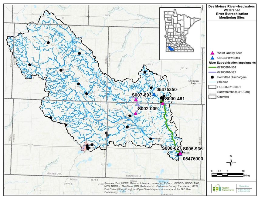
Figure 15. The number of reported BMPs installed by subwatershed in the Des Moines River Headwaters
Watershed................................................................................................................................................... 45
Figure 16. Reinvest in Minnesota Reserve Conservation Easements by county in Minnesota broken out
by type. ....................................................................................................................................................... 48
Figure 17. Funds spent in the Des Moines River Headwaters Watershed for conservation practices,
shown by pollution type, funding sources and year, according to the MPCA Healthier Watersheds
website (MPCA 2020b). .............................................................................................................................. 50
Figure 18. Adaptive management concept. ................................................................................................ 55

Des Moines River Headwaters Watershed RES TMDL Report                                                                      Minnesota Pollution Control Agency
                                                                                 v
Acronyms
AFO                                    Animal Feeding Operation
AU                                     Animal units
AUID                                   Assessment Unit ID
AWWF                                   Average Wet Weather Flow
BMP                                    Best Management Practice
BOD5                                   5-day biological oxygen demand
BWSR                                   Board of Water and Soil Resources
CAFO                                   Concentrated Animal Feeding Operation
cfs                                    Cubic foot per second
CREP                                   Conservation Reserve Enhancement Program
CRP                                    Conservation Reserve Program
CWA                                    Clean Water Act
CWLA                                   Clean Water Legacy Act
DOFlux                                 Diel dissolved oxygen flux
DNR                                    Minnesota Department of Natural Resources
E. coli                                Escherichia coli
EPA                                    U.S. Environmental Protection Agency
EQuIS                                  Environmental Quality Information System
HSPF                                   Hydrologic Simulation Program-Fortran
HUC-08                                 8-digit Hydrologic unit code
HUC-10                                 10-digit Hydrologic unit code
IPHTs                                  Imminent public health threats
kg/day                                 Kilogram per day
kg/yr                                  Kilogram per year
LA                                     Load allocation
lb                                     Pound
lbs/ac                                 Pounds per acre
lbs/day                                Pounds per day
LC                                     Loading capacity
LGU                                    Local Government Unit

Des Moines River Headwaters Watershed RES TMDL Report                              Minnesota Pollution Control Agency
                                                            vi
m                                      Meter
MAWQCP                                 Minnesota Agricultural Water Quality Certification Program
mg/L                                   Milligrams per liter
MOS                                    Margin of safety
MPCA                                   Minnesota Pollution Control Agency
MS4                                    Municipal Separate Storm Sewer Systems
NLCD                                   National Land Cover Dataset
NPDES                                  National Pollutant Discharge Elimination System
NPS                                    Nonpoint source
NRCS                                   Natural Resource Conservation Service
NRS                                    Nutrient Reduction Strategy
NSE                                    Nash-Sutcliffe Efficiency
PWP                                    Permanent Wetland Preserve
RC                                     Reserve Capacity
RES                                    River eutrophication standard
RIM                                    Reinvest in Minnesota
SDS                                    State Disposal System
sq mi                                  Square mile
SSTS                                   Subsurface Sewage Treatment Systems
SWCD                                   Soil and Water Conservation District
TMDL                                   Total Maximum Daily Load
TP                                     Total phosphorus
ug/L                                   Microgram per liter
WLA                                    Wasteload allocation
WPLMN                                  Watershed Pollutant Load Monitoring Network
WQBELs                                 Water quality based effluent limits
WRAPS                                  Watershed Restoration and Protection Strategy
WRP                                    Wetland Reserve Program
WTP                                    Water treatment plant
WWTP                                   Wastewater treatment plant

Des Moines River Headwaters Watershed RES TMDL Report                               Minnesota Pollution Control Agency
                                                              vii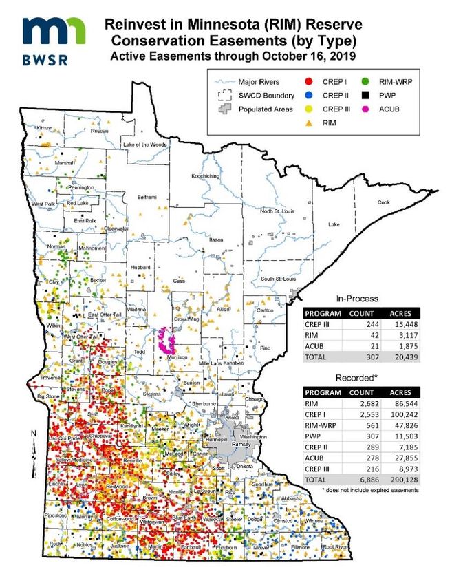
Executive summary
Section 303(d) of the Clean Water Act (CWA) provides authority for completing Total Maximum Daily
Load (TMDL) studies to achieve state water quality standards and/or designated uses. The TMDL
establishes the maximum amount of a pollutant a waterbody can receive on a daily basis and still meet
water quality standards. The TMDL is divided into wasteload allocations (WLAs) for point or permitted
sources, load allocations (LAs) for nonpoint sources (NPSs) and natural background, a margin of safety
(MOS), and a reserve capacity (RC).
This report addresses two river eutrophication standard (RES) impaired stream reaches listed on the
Section 303(d) impaired waters list within the Des Moines River Headwaters Watershed, 8-digit
hydrologic unit code (HUC-08) 07100001. River eutrophication impairments are treated as phosphorus
impairments. Addressing multiple impairments in one TMDL report is consistent with Minnesota’s
Water Quality Framework that seeks to develop watershed-wide protection and restoration strategies
rather than focus on individual reach impairments.
The Des Moines River Headwaters Watershed, located in southwestern Minnesota, drains
approximately 801,772 acres of six counties (Cottonwood, Jackson, Lyon, Murray, Nobles, and
Pipestone). There are 14 communities in the watershed, the largest of which are the cities of
Worthington, Slayton, Windom, Lakefield, Heron Lake, and Fulda. Heron, Shetek, and Sarah lakes are in
this watershed. Larger streams and rivers include Okabena Creek, Elk Creek, Jack Creek, Beaver Creek,
Lime Creek, and the West Fork Des Moines River. The outlet of the Des Moines River Headwaters flows
into the Lower Des Moines River (07100002) in Jackson, Minnesota.
This TMDL report used a variety of methods to evaluate current loading contributions by the various
pollutant sources, as well as the allowable pollutant loading capacity (LC) of the impaired water bodies.
These methods include the Hydrological Simulation Program – FORTRAN (HSPF) model and the flow
duration curve approach. This TMDL report was developed in conjunction with a basin-wide TMDL
report, which addresses multiple impairments throughout the watersheds of the basin, including the
Des Moines River Headwaters Watershed (07100001) and the Minnesota portions of the Lower Des
Moines River (07100002) Watershed and the East Fork Des Moines River (07100003).
A general strategy and cost estimate for implementation to address the impairments are included. NPS
will be the focus of implementation efforts. NPS contributions are not regulated and implementation
efforts will need to proceed on a voluntary basis. Permitted point sources will be addressed through the
Minnesota Pollution Control Agency’s (MPCA) National Pollutant Discharge Elimination System
(NPDES)/State Disposal System (SDS) Permit programs.

Des Moines River Headwaters Watershed RES TMDL Report                           Minnesota Pollution Control Agency
                                                        viii
1.         Project overview
1.1        Purpose
The CWA Section 303(d) requires that states publish a list of surface waters that do not meet water
quality standards, and therefore do not support their designated use(s). These waters are then classified
as impaired, which dictates that a TMDL must be completed to address them. The TMDL calculates the
maximum amount of a pollutant that a waterbody can receive and still meet water quality standards,
and allocates pollutant loads across the sources of pollutants.
The passage of Minnesota’s Clean Water Legacy Act (CWLA) in 2006 and the Clean Water Land and
Legacy Amendment in 2008 provided a policy framework and resources to state and local governments
to accelerate efforts to monitor, assess and restore impaired waters and to protect unimpaired waters.
The result has been a comprehensive “watershed approach” that integrates water resource
management efforts, local governments, and stakeholders to develop watershed-scale TMDL reports,
restoration and protection strategies, and plans for each of Minnesota’s 80 major watersheds. The
information gained and strategies developed in the watershed approach are presented in major
watershed-scale Watershed Restoration and Protection Strategy (WRAPS) reports, which guide
restoration and protection of streams, lakes, and wetlands across the watershed, including those for
which TMDL calculations are not made.
This report addresses two RES impaired stream reaches in the Des Moines River Headwaters Watershed
listed on the 303(d) Impaired Waters list. The Des Moines River Headwaters Watershed boundaries
presented in this TMDL report cover portions of six counties in Minnesota, including Cottonwood, Lyon,
Murray, Jackson, Nobles, and Pipestone.
The goal of this TMDL is to quantify the pollutant reductions needed to meet state water quality
standards for RES impairments, treated as phosphorus, for river reaches identified in Table 1 and
Figure 1. This TMDL report is developed and established in accordance with Section 303(d) of the CWA
and provides WLAs and LAs for the watershed as appropriate. This report addresses RES impairments
identified in the most recent monitoring and assessment cycle and uses the most recent methods and
data available at the time of this report.
This TMDL report is developed in conjunction with a separate watershed-wide TMDL report. The
watershed-wide report addresses additional impaired streams and lakes, including 1 chloride
impairment, 2 turbidity/TSS impairments and 10 bacteria (Escherichia coli [E. coli]) impairments in 13
stream reaches, and 23 excessive lake nutrients (phosphorus) impairments in the Des Moines River
Basin (MPCA 2020d). A previous TMDL report was completed in the Des Moines River Basin in 2008. The
West Fork Des Moines River Watershed TMDL Final Report: Excess Nutrients (North and South Heron
Lakes), Turbidity, and Fecal Coliform Bacteria Impairments (MPCA 2008) was approved by the U.S.
Environmental Protection Agency (EPA) in 2008 and an implementation plan, the West Fork Des Moines
River and Heron Lake TMDL Implementation Plan (Heron Lake Watershed District 2009), was approved
by the MPCA in 2009. The previous report addressed a total of 33 impairments covering lake nutrients,
turbidity, fecal coliform bacteria and pH in the Des Moines River Headwaters and Lower Des Moines
River Watersheds. For more information, see West Fork Des Moines River Watershed TMDL Final Report:
Excess Nutrients (North and South Heron Lake), Turbidity, and Fecal Coliform Bacteria Impairments. The

Des Moines River Headwaters Watershed RES TMDL Report                          Minnesota Pollution Control Agency
                                                        9
watershed-wide TMDL report revises the North and South Heron Lakes TMDLs due to the availability of
additional data and a watershed-wide HSPF model.
Previous effluent limit review efforts have determined facilities upstream of North Heron Lake and
Talcot Lake have reasonable potential to cause or contribute to an exceedance in lake eutrophication
standards. Reasonable potential analysis for facilities downstream of the lakes was completed to
determine if they contribute to the RES impairments in reach 07100001-501 and 07100001-527. Based
on the previous effluent review and the reasonable potential analysis, it was determined a boundary
condition is needed. The boundary condition determination discussion is further described in Section
4.1.2.
1.2 Identification of waterbodies
This TMDL report addresses two river eutrophication impairments listed on the 2018 303(d) impaired
waterbodies list for the Des Moines River Headwaters Watershed, and are listed in Table 1. Figure 1
shows the location of the impaired reaches in the Des Moines River Headwaters Watershed.
Table 1. Stream reach impairments addressed in this TMDL report.
Watershed Assessment Impairment/ Designated Beneficial Listing
Waterbody
(HUC-08) Unit ID Parameter Class Use1 Year
Des Moines River, Windom Dam River
Des Moines 07100001-501 2Bg, 3C AQR 2018
to Jackson Dam Eutrophication
River-
Headwaters Heron Lake Outlet, Heron Lk (32- River
(07100001) 07100001-527 2Bg, 3C AQR 2018
0057-01) to Des Moines R Eutrophication
1AQR = Aquatic recreation.
1.3 Priority ranking
The MPCA’s schedule for TMDL completions, as indicated on Minnesota’s Section 303(d) impaired
waters list, reflects Minnesota’s priority ranking of this TMDL report. The MPCA has aligned TMDL
priorities with the watershed approach and WRAPS schedule. The MPCA developed a state plan
Minnesota’s TMDL Priority Framework Report (2015a) to meet the needs of EPA’s national measure
(WQ-27) under EPA’s Long-Term Vision (2013) for Assessment, Restoration and Protection under the
CWA Section 303(d) Program. As part of these efforts, the MPCA identified water quality impaired
segments that will be addressed by TMDLs by 2022. The Des Moines River Headwaters Watershed
waters addressed by this TMDL report are part of that MPCA prioritization plan to meet EPA’s national
measure.
Des Moines River Headwaters Watershed RES TMDL Report Minnesota Pollution Control Agency
10Figure 1. Impaired waters in the Des Moines River Headwaters Watershed addressed in this TMDL report.
Des Moines River Headwaters Watershed RES TMDL Report Minnesota Pollution Control Agency
112. Applicable water quality standards and
numeric water quality targets
The criteria used to determine stream and lake impairments are outlined in the MPCA’s document
Guidance Manual for Assessing the Quality of Minnesota Surface Waters for the Determination of
Impairment: 305(b) Report and 303(d) List (MPCA 2018). Minn. R. ch. 7050.0470 lists waterbody
classifications and Minn. R. ch. 7050.2222 lists applicable water quality standards.
The Minnesota narrative water quality standard for all Class 2 waters (Minn. R. 7050.0150, subp. 3)
states that:
The aquatic habitat, which includes the waters of the state and stream bed, shall not be degraded
in any material manner, there shall be no material increase in undesirable slime growths or
aquatic plants, including algae, nor shall there be any significant increase in harmful pesticide or
other residues in the waters, sediments, and aquatic flora and fauna; the normal fishery and
lower aquatic biota upon which it is dependent and the use thereof shall not be seriously impaired
or endangered, the species composition shall not be altered materially, and the propagation or
migration of the fish and other biota normally present shall not be prevented or hindered by the
discharge of any sewage, industrial waste, or other wastes to the waters.
The impaired waters covered in this TMDL report are classified as Class 2Bg. Relative to aquatic life and
recreation, the designated beneficial uses for the most stringent classifications, 2B waters, are:
Class 2B waters – The quality of class 2B surface waters shall be such as to permit the
propagation and maintenance of a healthy community of cool or warm water aquatic biota, and
their habitats according to the definitions in subpart 4c. These waters shall be suitable for aquatic
recreation of all kinds, including bathing, for which the waters may be usable. This class of
surface water is not protected as a source of drinking water (Minn. R. ch. 7050.0222, subp. 4).
The water quality standards shown in Table 2 are the numeric water quality target for each parameter
shown. For more detailed information refer to Minn. R. 7050.0222.
The RES consist of two parts, requiring an exceedance of the causative variable and a response variable,
which indicates the presence of eutrophication. The causative variable is total phosphorus (TP). The
response variables include chlorophyll-a, diel dissolved oxygen flux (DOFlux), 5-day biochemical oxygen
demand (BOD5), or pH. Water quality standards for the response variables must be met, in addition to
meeting phosphorus limits, for the water body to be considered meeting standards. The MPCA
evaluated extensive datasets from across the state to establish clear relationships between the causal
factor TP and the response variables. It is expected that by meeting the TP target, the response variables
(Table 2) will also be met. The RES apply to summer month mean values, for June to September. The Des
Moines River Headwaters Watershed is located in the Southern River Nutrient Region and has a TP
standard of 150 microgram per liter (ug/L) or 0.15 milligrams per liter (mg/L). For more information on
the development of Minnesota’s RESs, please see Minnesota Nutrient Criteria Development for Rivers
(MPCA 2013a).
Des Moines River Headwaters Watershed RES TMDL Report Minnesota Pollution Control Agency
12Table 2. Surface Water quality standards for Des Moines River Headwaters Watershed stream reaches addressed in this
TMDL report.
Water Quality Period of Time
Standard Parameter Units Criteria
Standard Standard Applies
Total phosphorus
Not to exceed 150 ug/L Summer Mean June - September
(causative1)
Chlorophyll-a
Not to exceed 35 ug/L Summer Mean June - September
(response2)
River
Eutrophication- Diel dissolved oxygen flux
Not to exceed 4.5 mg/L Summer Mean June - September
Southern Rivers (response2)
Nutrient Region 5-day biological oxygen
demand Not to exceed 3.0 mg/L Summer Mean June - September
(response2)
pH Not to be less than 6.5
su3 Summer Mean June - September
(response2) or greater than 9.0
1Primary, causative indicator of impairment; must be exceeded to be assessed as impaired.
2Secondary, response indicator of impairment; one of the four response parameters must be exceeded to be assessed as
impaired.
3pH is standard units.
3. Watershed and waterbody characterization
The Des Moines River Headwaters Watershed is located in southwestern Minnesota, and encompasses
part of the Western Corn Belt Plains and the Northern Glaciated Plains Region. The watershed covers an
area of 1,253 square miles ([sq mi] approximately 801,772 acres) and extends across six counties:
Cottonwood, Jackson, Lyon, Murray, Nobles, and Pipestone. The headwaters of the Des Moines River
originate in the northwestern part of the watershed in a poorly drained region from its principal source,
Lake Shetek. The Des Moines River flows from the Lake Shetek outlet southeasterly for 94 miles to the
Minnesota/ Iowa border, through Des Moines, Iowa, and eventually drains to the Mississippi River at
Keokuk, Iowa. No part of the Des Moines River Headwaters Watershed is located within the boundary of
a Native American Reservation.
The watershed lies on the Coteau des Prairies, a prominent upland in southern Minnesota with a flat
iron-shaped plateau that rises to an altitude of more than 1,900 feet (579 m) within the watershed. The
western boundary was formed during the late Wisconsin Glaciation and is a terminal moraine. The
northern and eastern boundaries of the watershed are also morainic highs formed during recession of
the Des Moines lobe during the late Wisconsin Glaciation. The Des Moines River Headwaters Watershed
is comprised of glacial deposits reaching a thickness of approximately 900 feet (275 m), with numerous
small glacial lakes.
Figure 2 shows the presettlement vegetation in the Des Moines River Headwaters Watershed (DNR
1994), with the main presettlement vegetation classified as prairie. The Des Moines River Headwaters
Watershed was largely settled by Europeans between the 1850s and the 1870s, and the majority of the
land use changes occurred since then. Additional land use conversion has continued with approximately
81% of the watershed in row crop agriculture, approximately 6% in pasture or grassland, 3% in
waterbodies or marshes, approximately 6% urban, and 1.1% forested. Lands adjacent to the Des Moines
River are heavily utilized for pasture, cropland, and urban development, with a narrow riparian corridor.
Des Moines River Headwaters Watershed RES TMDL Report Minnesota Pollution Control Agency
13Figure 2. Pre-European settlement vegetation for the Des Moines River Headwaters Watershed.
Des Moines River Headwaters Watershed RES TMDL Report Minnesota Pollution Control Agency
14These changes have resulted in the loss of more than 95% of the historic prairie and wetland
communities within the Des Moines River Headwaters Watershed. The current land base is a highly-
productive agricultural region characteristic of the loess- and glacial flour- derived soils and precipitation
patterns.
3.1 Streams
This TMDL report covers two stream reaches, identified by assessment unit identification (AUID)
numbers, with RES impairments. Reach information for each RES impaired stream are presented in
Table 3.
Table 3. Approximate drainage area of impaired stream reaches.
Total
Reach
Watershed Drainage
Stream/Reach Name AUID Length
(HUC-08) Area
[miles]
[sq mi]
Des Moines River, Windom Dam to Jackson Dam 07100001-501 1,241 24.86
Des Moines
River-
Headwaters
(07100001) Heron Lake Outlet, Heron Lk (32-0057-01) to Des
07100001-527 443.6 13.61
Moines R
3.2 Subwatersheds
The headwaters of the Des Moines River flows southeast from the Shetek Lake Subwatershed
(headwaters, 0710000102) through watersheds with prominent shallow, natural lakes. The Shetek Lake
Subwatershed (HUC-10) is first joined by Beaver Creek Subwatershed (0710000101) and becomes the
Talcot Lake-Des Moines River Subwatershed (0710000108). Several HUC-10 subwatersheds in the
southern tier of counties then join the Des Moines River, including Lime Creek (0710000104), Okabena
Creek (0710000107), Jack Creek (0710000107), and Heron Lake (0710000108) subwatersheds, prior to
becoming the city of Windom-Des Moines River Subwatershed (0710000108). Near Jackson, Minnesota
the Des Moines River then flows into the Lower Des Moines River Watershed (07100002) and flows into
Iowa. Figure 3 show the HUC-10 subwatersheds for the Des Moines River-Headwaters Watershed. Table
4 provides a list of impairments addressed in this TMDL report located in each HUC-10 subwatershed.
Table 4. Impairments in each HUC-10 subwatershed.
HUC-10 AUID/ Impairment/
HUC-08 Waterbody
Subwatershed DNR Lake ID Parameter
Heron Lake Heron Lake Outlet, Heron Lk (32-
07100001-527 River Eutrophication
Des Moines (0710000107) 0057-01) to Des Moines R
River-
Headwaters City of Windom-
(07100001) Des Moines River, Windom Dam to
Des Moines River 07100001-501 River Eutrophication
Jackson Dam
(0710000108))
Des Moines River Headwaters Watershed RES TMDL Report Minnesota Pollution Control Agency
15The drainage areas for the two RES impaired reaches are shown in Figure 4. Reach 07100001-501
watershed drains 1,241 sq mi, and includes all eight of the HUC-10 subwatersheds in the Des Moines
River Headwaters Watershed. Reach 07100001-527 watershed drains approximately 444 sq mi, and
includes four HUC-10 subwatersheds, including Lime Creek (0710000103), Jack Creek (0710000106),
Okebena Creek (0710000105), and Heron Lake (0710000107).
Des Moines River Headwaters Watershed RES TMDL Report Minnesota Pollution Control Agency
16Figure 3. Des Moines River-Headwaters Watershed HUC-10 Subwatersheds.
Des Moines River Headwaters Watershed RES TMDL Report Minnesota Pollution Control Agency
17Figure 4. Drainage areas of RES impaired streams in the Des Moines River-Headwaters Watershed.
Des Moines River Headwaters Watershed RES TMDL Report Minnesota Pollution Control Agency
183.3 Land use
The land use for the Des Moines River-Headwaters Watershed and HUC-10 subwatersheds are
summarized in Table 5 and shown in Figure 5. Row crop is the largest land use in each subwatershed,
and the watershed as a whole, with wetlands and lakes more common in low-relief subwatersheds.
Drainage is prominent in the Beaver Creek, Okabena Creek, and Heron Lake subwatersheds where
upland sloughs were historically prominent. However, drainage throughout the entirety of the Des
Moines River Headwaters Watershed is common. The conversion of native vegetation to agricultural
lands has resulted in increased overland flow, decreased groundwater recharge (lower groundwater
infiltration), and increased the NPS transport of sediment, nutrients, chemical (agricultural and
residential), and feedlot runoff.
Groundwater recharge in the region is slow and varies from 0 to 6 inches per year (MPCA 2017b). High
agricultural land use contributes to high nutrient, sediment, and bacterial export as well, which can
impact both surface waters and aquifers. Agricultural land use exceeds 80% in the watershed and
receiving surface- and ground- water reflect these uses with elevated nutrient and bacterial loading
common throughout the watershed.
Table 5. Land cover (MRLC 2011) in the Des Moines River-Headwaters Watershed
Open Forest/ Barren/
HUC-08/HUC-10 Cropland Rangeland Developed Wetland
Water Shrub Mining
Subwatershed3 [%] [%] [%] [%]
[%] [%] [%]
Des Moines River-
Headwaters 81.1 5.9 6.0 3.1 2.9 1.1 0.03
(07100001)
Beaver Creek
82.2 9.8 5.1 1.8 0.6 0.4 0.02
(0710000101)
Lake Shetek
72.0 8.7 5.4 3.2 10.3 0.3 0.04
(0710000102)
Lime Creek
83.5 4.4 6.4 3.4 1.7 0.5 0.01
(0710000103)
Talcot Lake-Des Moines
80.0 6.3 4.7 5.5 2.9 0.4 0.07
River (0710000104)
Okabena Creek
88.1 1.7 8.2 1.2 0.2 0.6 0.02
(0710000105)
Jack Creek
87.9 2.3 5.2 2.3 1.4 0.9 0.02
(0710000106)
Heron Lake
76.7 2.1 6.1 5.6 7.8 1.7 0.02
(0710000107)1
City of Windom-Des
Moines River 76.6 9.4 6.9 2.8 1.4 2.9 0.04
(0710000108)2
1HUC-10 includes reach 07100001-527.
2HUC-10 includes reach 07100001-501.
3Totals of percentages may not equal 100% due to rounding errors.
Des Moines River Headwaters Watershed RES TMDL Report Minnesota Pollution Control Agency
19Figure 5. Land use/Land cover (MRLC 2011) in the Des Moines River-Headwaters Watershed.
Des Moines River Headwaters Watershed RES TMDL Report Minnesota Pollution Control Agency
203.4 Current/historical water quality
Existing water quality conditions are described using data downloaded from the MPCA’s Environmental
Quality Information System (EQuIS) database1. EQuIS stores data collected by the MPCA, partner
agencies, grantees, and citizen volunteers. All water quality sampling data utilized for assessments,
modeling, and data analysis, for this report and reference reports, are stored in this database and are
accessible through the MPCA’s Environmental Data Access website1. Data from the current 10-year
assessment period (2006 through 2015), consistent with the time period for the application of the water
quality numeric standards, were used for development of this TMDL report. Various agencies and local
partners, such as the MPCA, Soil and Water Conservation Districts (SWCD), local watershed districts, and
volunteer monitoring programs collected data to develop this TMDL report. Figure 6 shows the locations
of water quality sites used to develop this TMDL report.
Phosphorus and the available response variables (chlorophyll-a, pH, and/or BOD5) data are summarized
by watershed, AUID, and station in Table 6 for each impaired stream addressed in this TMDL report. The
RES impairments are based on the Southern Rivers Nutrient Region TP standard of 150 ug/L.
Chlorophyll-a has a numeric standard of 35 ug/L for the Southern Rivers Nutrient Region, BOD5 has a
numeric standard of 3.0 mg/L, diel DOFlux is not to exceed 4.5 mg/L, and pH must be greater than 6.5 but
less than 9, all for Class 2B waters in the Southern Rivers Nutrient Region.
Table 6. Current condition in river eutrophication impairments and water quality sites in the Des Moines River Headwaters
Watershed
Summer
Number of Number of
AUID Station Parameter Period Average
samples Exceedances
(Jun-Sept)
Phosphorus (ug/L) 2014-2015 14 232 14
S000-027 Chlorophyll a (ug/L) 2015 6 40.6 2
pH 2014-2015 21 8.5 0
Phosphorus (ug/L) 2014-2015 9 252 8
07100001-501 S000-481
pH 2014-2015 21 8.4 0
Phosphorus (ug/L) 2010-2015 66 218 46
S005-936 Chlorophyll a (ug/L) 2011-2013 10 122 7
pH 2010-2015 59 8.1 0
Phosphorus (ug/L) 2005-2015 137 237 96
Five-day Biological Oxygen
S002-009 2006-2008 30 9.3 29
Demand (mg/L)
pH 2006-2015 130 8.2 16
07100001-527
Phosphorus (ug/L) 2014-2015 14 216 10
S007-893 Chlorophyll a (ug/L) 2014-2015 12 23.9 3
pH 2014-2015 20 8.3 0
1
https://www.pca.state.mn.us/environmental-data
Des Moines River Headwaters Watershed RES TMDL Report Minnesota Pollution Control Agency
21Figure 6. Monitoring locations in impaired stream reaches addressed in this TMDL report.
Des Moines River Headwaters Watershed RES TMDL Report Minnesota Pollution Control Agency
22Two monitoring sites in the watershed are part of the MPCA’s Watershed Pollutant Load Monitoring
Network (WPLMN) database2; one watershed outlet site (Jackson) and one up-stream subwatershed site
(Avoca). The WPLMN is a long-term program designed to measure and compare pollutant load
information from Minnesota’s streams and track water quality trends. Over the years of 2008 through
2015 at the Des Moines River at Jackson, the months of March, June, and July each accounted for 15%
to 20% of the load (Figure 7). Over a more recent period of record (2013 through 2015), a significant
portion of the load was delivered in June alone: 38% at the Jackson site and 56% at the seasonal Avoca
site.
Figure 7. 2008-2015 total phosphorus WPLMN load data from the Des Moines
River at Jackson (MPCA 2020c).
3.5 Pollutant source summary
3.5.1 River Eutrophication (Total Phosphorus-Streams)
Sources of phosphorus to impaired reaches addressed in this TMDL report include both point and NPS.
Point sources of pollution only include those sources that are regulated through NPDES permits in the
impaired watersheds and include permitted stormwater, wastewater, and NPDES-permitted
concentrated animal feeding operation (CAFO). Nonpermitted or NPSs include such things as
unregulated watershed runoff, septic systems, non-NPDES permitted animal feeding operations (AFOs),
streambank erosion, and atmospheric deposition. Individual sources of phosphorus are discussed in
detail below.
A numeric estimate of the distribution of phosphorus sources in the watershed is presented in Figure 8.
Figure 8 was created using multiple lines of evidence, including the Des Moines River Basin HSPF model
and local knowledge (MPCA 2020c). Agricultural land uses, including both surface and tile discharge,
were estimated to be the largest source of phosphorus. Much of the phosphorus leaving agricultural
fields is from applied fertilizer and manure, while some is also from phosphorus native to the soil.
2
https://www.pca.state.mn.us/water/watershed-pollutant-load-monitoring
Des Moines River Headwaters Watershed RES TMDL Report Minnesota Pollution Control Agency
23Figure 8. Sources of phosphorus in the Des Moines River watersheds based on the Des Moines River Basin WRAPS report
findings (MPCA 2020c).
3.5.1.1 Permitted sources
Permitted sources account for 9% of the phosphorus load in the watershed (Figure 8). Permitted sources
include permitted feedlots, wastewater treatment plants (WWTP), construction stormwater, industrial
stormwater, and municipal stormwater. Each is discussed in detail below.
Feedlot Facilities
In Minnesota, AFOs are required to register with their respective delegated county or the state if they
are 1) an animal feedlot capable of holding 50 or more animal units (AU), or have a manure storage area
capable of holding the manure produced by 50 or more AUs outside of shoreland; or 2) an animal
feedlot capable of holding 10 or more AUs, or have a manure storage area capable of holding the
manure produced by 10 or more AUs, that is located within shoreland. Further explanation of
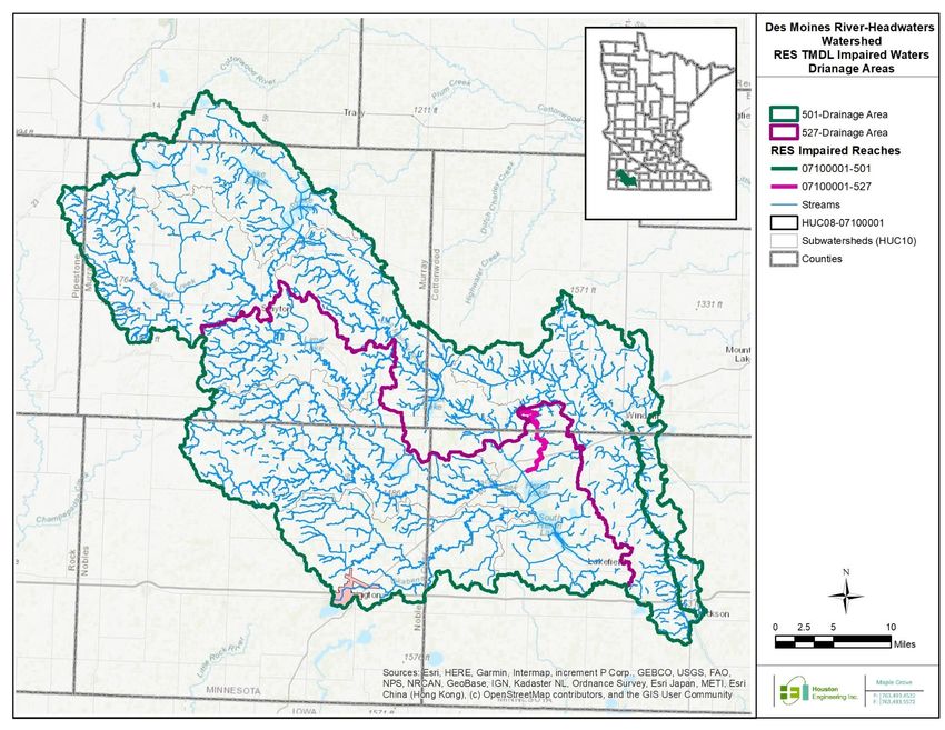
registration requirements can be found in Minn. R. 7020.0350. Figure 9 shows the locations and AUs for
registered feedlots in the Des Moines River Headwaters Watershed.
Of the approximately 527 AFOs with 215,493 AUs, in the Des Moines River Headwaters Watershed, 49
are CAFOs. CAFOs are defined by the EPA based on the number and type of animals. See Appendix A for
the complete list of CAFOs in the Des Moines River Headwaters Watershed. The MPCA currently uses
the federal definition of a CAFO in its permit requirements of animal feedlots along with the definition
of an AU. In Minnesota, the following types of livestock facilities are required to operate under a NPDES
Permit or a state issued SDS Permit: a) all federally defined CAFOs that have had a discharge, some of
which are under 1,000 AUs in size; and b) all CAFOs and non-CAFOs that have 1,000 or more AUs.
CAFOs and AFOs with 1,000 or more AUs must be designed to contain all manure and manure
contaminated runoff from precipitation events of less than a 25-year - 24-hour storm event. Having and
complying with an NPDES permit allows some enforcement protection if a facility discharges due to a
25-year - 24-hour precipitation event (approximately 5.2 inches in 24 hours) and the discharge does not
contribute to a water quality impairment. Large CAFOs permitted with an SDS permit or those not
Des Moines River Headwaters Watershed RES TMDL Report Minnesota Pollution Control Agency
24covered by a permit must contain all runoff, regardless of the precipitation event. Therefore, many large
CAFOs in Minnesota have chosen to have an NPDES permit, even if discharges have not occurred in the
past at the facility. A current manure management plan, which complies with Minn. R. 7020.2225, and
the respective permit, is required for all CAFOs and AFOs with 1,000 or more AUs.
CAFOs are inspected by the MPCA in accordance with the MPCA NPDES Compliance Monitoring Strategy
approved by the EPA. All CAFOs (NPDES permitted, SDS permitted, and not required to be permitted)
are inspected by the MPCA on a routine basis with an appropriate mix of field inspections, offsite
monitoring and compliance assistance.
Wastewater Treatment Plants
WWTPs can contribute phosphorus to lakes and streams. There are 19 NPDES wastewater permits in
Des Moines River Headwaters Watershed; 12 of them are municipal wastewater permits and 7 are
industrial permits. Only three NPDES permits were given WLAs (see Section 4.3.3) due to the boundary
condition (see Section 4.1.2). The WLAs result in a new phosphorus effluent limit for one facility and are
consistent with either current or already established future phosphorus effluent limits in the other two.
Effluent limits continue to be reviewed every five years as part of the permit review process, and
additional or modified limits will be dependent on the receiving water body of the treated water and the
broader watershed context. All facilities in the Des Moines River Headwaters Watershed have
undergone an MPCA watershed phosphorus review. Watershed scale phosphorus effluent limit reviews
are developed to establish the need for TP effluent limits and monitoring requirements for NPDES
permitted wastewater treatment facilities. Phosphorus permit limits are based on the potential of a
facility to contribute to a downstream water that exceeds lake or RESs. Procedures for implementing
RESs in NPDES wastewater permits in Minnesota (MPCA 2015b) outlines the analysis and calculations
used to establish necessary phosphorus limits. All facilities in the Des Moines River Headwaters
Watershed that hold a permit were invited to attend a meeting in November, 2019 to learn about the
TMDL WLAs and the impacts to phosphorus permit limits (see Section 9).
Construction Stormwater
Construction stormwater can be a source of phosphorus due to runoff of phosphorus bound to
disturbed and easily erodible soils during construction activities. On average, there are approximately
400 acres (about 0.1%) in the watershed covered by a construction stormwater permit at any given
time. Construction stormwater permits require erosion control measures, so phosphorus from
construction is considered, but not a significant contributor of phosphorus.
Des Moines River Headwaters Watershed RES TMDL Report Minnesota Pollution Control Agency
25Figure 9. Permitted sources and feedlots in the Des Moines River Headwaters Watershed.
Des Moines River Headwaters Watershed RES TMDL Report Minnesota Pollution Control Agency
26Industrial Stormwater
Industrial stormwater can be a source of phosphorus. A phosphorus-containing material handled, used,
processed, or generated, when exposed to stormwater, may leak, leach, or decompose and be carried
offsite. There are seven NPDES permitted industrial stormwater permittees, but only one (Heron Lake
Bio Energy; NPDES Permit #MN0067385) received a WLA which is consistent with their current permit
(see Section 4.3.3) in the drainage area of the impaired rivers covered in this TMDL report, due to the
boundary condition (see Section 4.1.2). It is assumed that loads from permitted industrial stormwater
sites that operate in compliance with the permit are meeting the WLA.
Municipal Stormwater
Phosphorus from sediment, grass clippings, leaves, fertilizers, and other phosphorus-containing
materials can be a source of phosphorus and can be conveyed through stormwater pipe networks to
surface waters. Developed areas attribute approximately 4% of TP load in the Des Moines River Basin
watersheds (see Figure 8). The city of Worthington (MS4 Permit #MS400257) is the only Municipal
Separate Storm Sewer System (MS4) permitted area in the watershed and covers 4.15 sq mi in the
drainage area of both impaired reaches. Worthington did not receive a WLA (see Section 4.3.3) for
either impaired reach, due to the boundary condition (see Section 4.1.2).
3.5.1.2 Nonpermitted sources
NPSs (nonpermitted sources) include overland erosion and runoff, streambank erosion, non-NPDES
permitted AFOs, land applied manure, subsurface sewage treatment systems (SSTS), and atmospheric
deposition. NPSs account for 89% of the phosphorus load in the watershed (see Figure 8). Individual
NPSs of phosphorus are discussed in detail below.
Upland Erosion and Runoff
Soil erosion can source of nutrients because phosphorus often binds to sediment particles and can be
transported downstream along with the sediment. Upland erosion includes overland erosion and tile
lines with open tile intakes. In addition to sediment, organic materials often contain phosphorus and,
much like sediment, organic materials can be transported across the landscape with runoff. Overland
erosion can occur by sheet, rill, or gully modes of sediment transport that can convey phosphorus tightly
bound to sediment to surface waters. Upon the formation of a gully, these areas are sensitive and highly
susceptible to continued disturbance. In addition, dissolved phosphorus can be transported through tile
lines in agriculture areas. Protecting sensitive areas with deep-rooted vegetation that stabilizes soils can
help mitigate phosphorus loss. Minimizing uncovered fields can also reduce the erosive power of heavy
rain events.
Phosphorus loading from upland sources is estimated to be 0.3-0.6 lbs/acre annually for the Des Moines
River Headwaters Watershed. Overland runoff coupled with the high percentage of straightened stream
channels, agricultural land use, loss of wetlands and tiling – jointly indicating an altered hydrology –
increase the conveyance of phosphorus loss from the landscape to water bodies once mobilized from
soils.
Des Moines River Headwaters Watershed RES TMDL Report Minnesota Pollution Control Agency
27Stream Bank Erosion
Like overland erosion, phosphorus can be bound to sediment in streambanks and transported
downstream when erosion occurs, and thus be a source of phosphorus. During large precipitation
events or during spring snow melt, streams can convey water at high velocity and volumes with
significant stream energy. High stream power values commonly observed in the watershed exceed the
stress stream banks can withstand. This leads to bank failure and stream bank erosion, with sediment
and bound phosphorus transported downstream. The removal of natural vegetation can exacerbate
streambank erosion along a channel.
In addition, alterations to the stream reaches, e.g. channel widening and channel straightening, further
increase stream energy and likelihood of streambank erosion. Intense agricultural land use throughout
the watershed, specifically row crop production, has led to an altered hydrology for the region through
the drainage of wetlands and straightening of streams to facilitate farm needs. These landscape-scale
hydrological impacts have increased stream slope through straightening streams and the volume of
water drained annually. Increased stream slope and water conveyance increases the stream power and
the likelihood of streambank failure that can contribute to elevated in-channel phosphorus loads. Near
streambank and channel erosion accounts for 4% of TP loading in the watershed.
Non-NPDES Permitted Feedlots and Manure Application
AFOs under 1,000 AUs and those that are not federally defined as CAFOS do no operate with permits.
These facilities must operate their facilities in accordance with Minn. R. 7020.2000 through 7020.2150
to minimize their impact on water quality. AFOs may pose an environmental concern if the facilities are
located near water and manure is inadequately managed, especially in open lot feedlots. There are 337
facilities in the Des Moines River Headwater Watershed that have open lots. Of those with open lots, 39
are located within 1,000 feet of a lake or 300 feet of a stream.
Approximately 58% of the AUs in the watershed are swine and the majority of the manure is held in
liquid manure storage areas. Another 40% of the AUs are cattle and the manure is held in either liquid
manure storage areas or in stockpiles. When stored and applied properly, manure provides a natural
source for crop fertilizer.
However, manure can have a high content of phosphorus per unit of manure. Since manure can have
different ratios of nitrogen to phosphorus content, deliberate manure management measures must be
employed to ensure excessive phosphorus application do not occur if manure is applied based on
nitrogen rates. There is potentially a significant amount of winter application of manure onto snow
covered or frozen soils based on MPCA feedlot staff observation. High intensity precipitation events
during the spring can cause erosion of both the soil as well as the manure that is applied onto the soil,
leading to high phosphorus loads making their way to streams and lakes. Land applied manure from all
AFOs must comply with Minn. R. 7020.2225.
SSTS
Nutrients from SSTSs can be a source of phosphorus. Failing SSTS with an insufficient dry zone between
the leach field and bedrock or saturated zone, or improperly designed SSTS, can result in the transfer of
phosphorus to groundwater and surface waters. SSTSs that discharge untreated sewage to the land
surface are considered imminent public health threats (IPHTs). The approach to identifying IPHTs varies
Des Moines River Headwaters Watershed RES TMDL Report Minnesota Pollution Control Agency
28You can also read