Exploration and mining in the Skeena Region, British Columbia
←
→
Page content transcription
If your browser does not render page correctly, please read the page content below
Exploration and mining in the Skeena Region, British Columbia

  Jeff Kyba1, a
  1
      Regional Geologist, Ministry of Energy and Mines, 3726 Alfred Avenue, Smithers, BC, V0J 2N0
  a
      corresponding author: Jeff.Kyba@gov.bc.ca

  Recommended citation: Kyba, J., 2015. Exploration and mining in the Skeena Region, British Columbia. In: Exploration and Mining in British
  Columbia, 2014. British Columbia Ministry of Energy and Mines, British Columbia Geological Survey, Information Circular 2015-2, pp. 97-
  114.

  1. Introduction                                                           2. Regional geology
    Mineral exploration continued in the Skeena Region (Fig. 1)               The Skeena Region is underlain by autochthonous rocks
  despite challenging market conditions, and about 80 projects              of ancestral North America, parautochthonous terranes with
  were active (Fig. 2). Some major programs continued to drill,             North American affinities (Slide Mountain, Yukon-Tanana)
  expand, and define deposits, but most projects focused on                 and exotic terranes (Quesnel, Cache Creek, Stikine, Alexander)
  relatively inexpensive work such as soil sampling, prospecting,           that were accreted to the western North American margin
  and geological mapping. Total exploration expenditures                    (Fig. 1, Nelson et al., 2013). Metal prospects span a spectrum
  decreased 20% from 2013 levels to $161 million (Fig. 3).                  of deposit types including porphyry and intrusion-related,
  Similarly, exploration drilling decreased by 39% to 151,204               volcanogenic massive sulphides, precious metal veins, skarns,
  metres (Fig. 4). Mine development expenditures totalled about             sedimentary exhalite, Carlin-type gold, and manto replacement.
  $208 million. At least $300 million was spent on infrastructure           The most economically significant deposits are porphyry and
  projects directly related to the mining and exploration industry          precious metal veins in Stikinia and Quesnellia. In the Skeena
  including hydro transmission lines and port expansions in                 Region, most occurrences are in Stikinia; an island arc terrane
  Stewart and Prince Rupert. In 2014,                                       analogous to the Philippines (Marsden and Thokelson, 1992).
    • Red Chris Development Company Ltd. (Imperial Metals                   Successions in Stikinia record three arc-building episodes:
         Corporation) crushed and stockpiled ore taken from                 Paleozoic (Stikine assemblage); Triassic (Stuhini Group);
         the Main and East zones of the Red Chris copper-gold               and Late Triassic-Jurassic (Hazelton Group). Most porphyry
                                                                            copper-gold mineralization in Stikinia formed between 220 Ma
         project (Fig. 5) and continued final stages of construction
                                                                            to 195 Ma (Logan and Mihalynuk, 2014).
    • Banks Island Gold Ltd. began producing at the Yellow
         Giant gold project
                                                                            3. Operating mines
    • Avanti Mining Inc. began construction activities at their
                                                                               The Huckleberry copper-gold-silver-molybdenum mine
         Kitsault molybdenum-silver project
                                                                            (Fig. 6; Table 1) is a porphyry deposit spatially related to
    • Seabridge Gold Inc. received their Environmental
                                                                            the Bulkley intrusions (late Cretaceous). In the Main zone,
         approval and initial construction permits for their KSM
                                                                            mineralization is in hornfelsed and fractured Hazelton Group
         gold-copper project                                                volcanic rocks adjacent to a 500 m-diameter granodiorite stock.
    • the Northwest Transmission line to Bob Quinn Lake and                 The mined-out East zone is centred on a 40 m-wide granodiorite
         extension to Red Chris was commissioned                            dike. Ore in both zones is in a stockwork of quartz, pyrite and
    • Pretium Resources Inc. delivered a feasibility study for              chalcopyrite, crosscut by gypsum-filled fractures. The mine
         their high-grade gold Brucejack project                            is operated by Huckleberry Mines Ltd. Ownership is divided
    • Gold Reach Resources Ltd. expanded resources at Ootsa                 between Imperial Metals Corporation (50%) and the Japan
         by 87%                                                             Group (50%) comprising of Mitsubishi Materials Corporation,
    • Colorado Resources Ltd. released a maiden resource at                 Dowa Mining Co. Ltd., and Furakawa. Co. Higher grades and
         the North ROK copper-gold project and completed an                 better recovery during 2013 resulted in a metal production
         exploration program at the KSP gold project                        increase of 17%. Total output was 18,693 tonnes copper, 92.8
    • Kaizen Discovery Inc. confirmed porphyry-style copper                 kilograms gold, and 7403.5 kilograms silver from 5,895,193
         mineralization at Tanzilla                                         tonnes of ore mined from the Main Zone Extension pit. Grades
    • A new copper-gold system, Pyramid, was discovered 50                  averaged 0.346% Cu with copper recoveries averaging 91.6%.
         km north of Dease Lake by Gold Jubilee Capital Corp.               Concentrate is trucked to the Port of Stewart and loaded onto
    • Doubleview Capital Corp. drilled 404 m grading 0.25%                  marine vessels destined for Asia.
         Cu and 0.25 g/t Au at the Hat project                              Milling operations were temporarily shut down in late February
  Industry activities are summarized herein by geographic area              after the mill was damaged. Short-term repairs allowed milling
  (Fig. 1, inset) and deposit stage.                                        to resume in early April and permanent repairs were completed

                                                                       97
Exploration and Mining in British Columbia, 2014. British Columbia Ministry of Energy and Mines, British Columbia Geological Survey IC 2015-2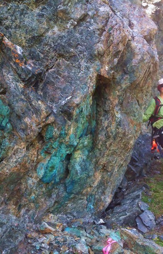
Kyba

  Fig. 1. Active mining and exploration projects Skeena Region, 2014. Cordilleran terranes after Nelson et al. (2013). Inset shows geographic areas
  discussed herein. Although the Fireside and Groundhog projects are not in the Skeena Region, they are reported on in this paper.

                                                                         98
Exploration and Mining in British Columbia, 2014. British Columbia Ministry of Energy and Mines, British Columbia Geological Survey IC 2015-2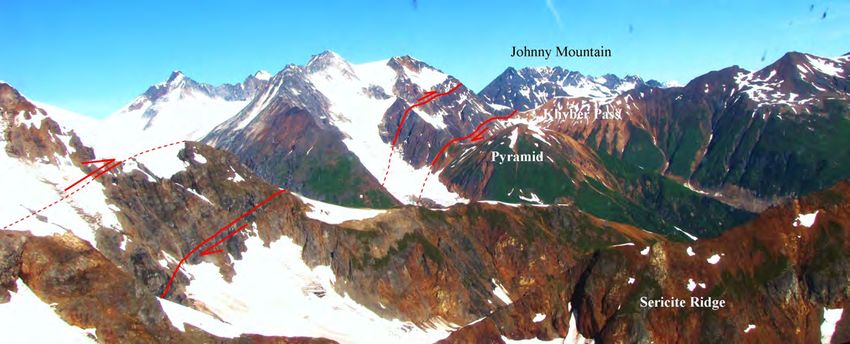
Kyba
Table 1. Operating mines in the Skeena Region, 2014.
Mine Operator Commodity; deposit Forecast 2014 Production Reserves Near-mine Website
type; MINFILE (based on Q1-Q3) exploration
Huckleberry Huckleberry copper, gold, silver, 16,329.3 tonnes (36 M lbs) 42.7 Mt at 0.330% soil sampling, http://www.
Mines Ltd. molybdenum copper, 90 kg (2900 oz) gold, copper and 0.009% claim imperialmetals.
093E 037 5443 kg (175,000 oz) silver molybdenum expansion com/s/
(December 31, 2013) HuckleberryMine.
asp
Fireside Fireside barite 35,000 tonnes 550,000 tonnes (non drilling http://www.
Minerals Ltd. 094M 003 43-101 compliant) firesideminerals.
com/
Yellow Giant Banks Island gold, silver 373 kg (12,002 oz) gold, 35,718 t at 19 g/t gold drilling http://www.
Gold Ltd. 103G 024, 26 1005 kg (32,321 oz) silver and 45 g/t silver (non banksislandgold.
43-101 compliant) com/s/Home.asp
400 380
374
350 351
350
310
300
270
Thousands of Metres 249
250
197
200
169
144 151
150
100 92
57
50 38
0
2001 2002 2003 2004 2005 2006 2007 2008 2009 2010 2011 2012 2013 2014
Year
Fig. 4. Annual exploration drilling estimates for the Skeena Region
from 2001-2014.
in November. Onsite infrastructure developments included
Fig. 2. Exploration expenditures in 2014 by exploration stage for the
commissioning and ongoing construction of the tailings storage
Skeena Region. facility and production of cyclone sands for incremental lifts of
dam material. The Main Zone Optimization project to remove
300
legacy tailings and waste rock from the former Main Zone Pit
285
(Fig. 6) continued for the third year. The project extends the
mine life to 2021 with reserves totalling approximately 33.8
250
220
Mt grading 0.343% Cu and 0.009% Mo at a 0.20% Cu cut-off
201 grade. Exploration was limited to reconnaissance-scale surveys
200
at the nearby Whiting Creek prospect.
Millions of Dollars
170 172
161 Fireside Minerals Ltd. continued to mine barite (Fig. 7) from
140
150
127
the Fireside mine. Barite is in steeply dipping veins in Kechika
Group sedimentary rocks near a Paleozoic (?) gabbro dike
100
100 (Wojdak, 2008). In 2014, production increased 30% from 2013
55
65 levels to approximately 32,000 tonnes from 36,000 tonnes
50 mined. Increased production was partly due to commissioning
10
21 of a second Raymond roller mill and packing system. A non
7
0 NI-43-101 compliant reserve estimate totals 550,000 tonnes.
2001 2002 2003 2004 2005 2006 2007 2008 2009 2010 2011 2012 2013 2014
Year Exploration drilling at the Moose Pit identified sufficient barite
Fig. 3. Annual exploration spending estimates for the Skeena Region resources to justify plans for its reactivation. Barite ore is
from 2001-2014. crushed, milled, and bagged onsite. It is sold mainly as a heavy
99
Exploration and Mining in British Columbia, 2014. British Columbia Ministry of Energy and Mines, British Columbia Geological Survey IC 2015-2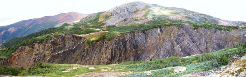
Kyba

  Fig. 5. Overview of the Red Chris copper-gold deposit.

  Fig. 6. Mining at Huckleberry Mines Main zone extension pit.

  Fig. 7. Barite mining at Fireside Minerals Bear Pit. Photo by Andrew         Fig. 8. Overlooking Banks Island Gold processing plant at Yellow
  Allan.                                                                       Giant.

  drilling fluid additive.                                                     gold mineralization at Quartz Hill, where drill hole QH-14-01
    Banks Island Gold Ltd. received Mines Act and                              returned 14.5 m grading 2.5 g/t Au including 2.25 m grading
  Environmental Management Act permits for their Yellow                        14.0 g/t Au. Further drilling is planned.
  Giant gold-silver mine on Banks Island, about 105 km south                      Nephrite jade is found in deformed serpentinites of the Cache
  of Prince Rupert. By the end of 2014, underground mining was                 Creek terrane (east of Dease Lake) and of the Slide Mountain
  well underway from the Bob and Tel portals. The processing                   terrane (at Cassier). It was mined from at least four quarries in
  facility (Fig. 8) was fully operational in early August. As of               the Dease Lake area: Provencher Lake, Kutcho, Cassiar,
  early June, the company reported producing 222.2 kg of gold                  and Dynasty. Jade sales are by private arrangement, and range
  (7,145 ounces) and 577.3 kg silver (18,559 ounces) from the                  from small, highly polished pendants to multi-tonne rough
  Bob zone (Fig. 9). Exploration defined a 600 m-long gold-                    boulders. Jade is generally mined from placer tenures, except
  in-soil anomaly. Follow-up drilling identified a new zone of                 at Dynasty, where it is mined from outcrops.

                                                                         100
Exploration and Mining in British Columbia, 2014. British Columbia Ministry of Energy and Mines, British Columbia Geological Survey IC 2015-2
Kyba

                                                                                    KSM consists of four deposits: Kerr, Sulphurets, Mitchell,
                                                                                 and Iron Cap. Proven plus Probable reserves total over 2.1
                                                                                 billion tonnes averaging 0.55 g/t Au and 0.21% Cu, forming
                                                                                 one of the largest undeveloped gold-copper porphyry resources
                                                                                 in North America. Measured plus Indicated resources (inclusive
                                                                                 of reserves) total 2,780 Mt grading 0.55 g/t Au, 0.21% Cu,
                                                                                 2.9 g/t Ag and 55 ppm Mo. Inferred resources total 1,127 Mt
                                                                                 grading 0.41 g/t Au, 0.17% Cu, 3.0 g/t Ag and 50 ppm Mo.
                                                                                 Recent exploration has found deeper zones and higher grades
                                                                                 that remain to be added to the mineral reserves and mine plan;
                                                                                 an updated resource estimate is expected in early 2015.
                                                                                    The KSM project is planned to operate over a 55 year mine
                                                                                 life with an estimated capital cost of $5.3 billion. The initial
                                                                                 25 years would be an open pit mining operation processing
                                                                                 130,000 t/d decreased to 90,000 t/d for the remaining 30
                                                                                 years. Ore would be fed to a floatation mill, produce a gold-
  Fig. 9. Gold-bearing chalcopyrite and interstitial sphalerite from the         copper-silver concentrate, and then trucked to the Stewart port
  Bob zone at Banks Island Gold’s Yellow Giant gold project.
                                                                                 facility. Metallurgical testing indicates that a clean 25% copper
                                                                                 concentrate can be produced, as well as a separate molybdenum
  4. Eskay-Stewart-Anyox area                                                    concentrate and gold-silver dore.
  The Eskay-Stewart-Anyox area, in western Stkinia, is bounded                      The KSM deposits are spatially and genetically related
  by the Iskut River, Bowser Basin, Nass River and the Alaskan                   to high-level diorite to monzonite plugs and dikes (Mitchell
  border. The area contains significant porphyry, volcanogenic                   intrusions) that that intrude Stuhini Group and Hazelton
  massive sulphide, and precious metal vein deposits (Fig. 1;                    Group rocks (Nelson and Kyba, 2014). The Mitchell zone
  Table 2).                                                                      (Febbo et al., 2015) is exposed in an erosional window
                                                                                 below the Mitchell thrust fault and consists of schistose rocks
  4.1. Proposed mines                                                            with abundant sericite, disseminated pyrite and a deformed
    The KSM gold-copper porphyry project (Seabride Gold Inc.)                    quartz-pyrite-chalcopyrite stockwork containing remarkably
  received provincial approval of an Environmental Assessment                    uniform copper and gold grades. Iron Cap is in the hanging
  application in late July and federal approval in mid-December.                 wall of the Mitchell thrust fault, and below the Sulphurets
  Significant pre-construction permits were also granted in                      thrust. Chalcopyrite occurs as fine disseminations and in
  September, allowing building of roads, construction camps,                     quartz-pyrite veins. Epithermal-style mineralization in quartz
  and rights-of-way to the Mitchell-Treaty tunnels, and site                     stockwork and breccias containing higher gold and silver
  preparations at the mine site and tailing management facility.                 grades are also present at Iron Cap. Original lithologic textures
  Ground-breaking activities are expected in 2015.                               are commonly obliterated by intense, pervasive silicification.
    Exploration activities included mapping and drilling at Deep                 However, in windows of weaker alteration, primary textures
  Kerr, MacQuillan and Iron Cap. Drilling followed up 2013                       are preserved including porphyritic intrusions and screens of
  results and totalled 29,508 m in 29 holes (Table 3). Thirteen                  pebble conglomerate. Quartz-rich arkose, granulestone, pebble
  holes totalling 12,900 m targeted Deep Kerr and are expected                   conglomerate, mudrocks, and andesitic volcanic rocks at Iron
  to increase the Inferred Resource estimate of 514 Mt grading                   Cap are considered part of the Jack Formation, the basal unit of
  0.53% Cu and 0.36 g/t Au (in addition to known reserves)                       the Hazelton Group, and are interpreted to have been deposited
  generated from 2013 drilling. Results expanded the deposit by                  adjacent to syndepositional faults that controlled late Triassic-
  400 m along strike and 300 m at depth. An updated resource                     Early Jurassic porphyry systems (Nelson and Kyba, 2014).
  estimate is expected in early 2015. The bottom of known                           Pretium Resources Inc. continued exploration and
  mineralization is now understood to be at a similar elevation as               development activities at the Brucejack-Snowfield high-
  the Sulphurets valley floor, allowing for potential underground                grade gold (Fig. 10) project, 65 km north of Stewart and 6
  access.                                                                        km from the KSM project. Efforts during 2014 were largely
    Approximately 10,429 m in 10 drill holes targeted the Lower                  focused on corporate initiatives to ensure that project financing
  Zone of the Iron Cap deposit, which is mostly below known Iron                 and permitting remained on schedule. The company’s
  Cap deposit reserves. Iron Cap now measures approximately                      Environmental Assessment application was formally accepted
  750 m along strike. Limits at depth and to the north have                      in mid-August. Surface drilling totalled 9,325 m in 7 drill
  not yet been defined. Drilling toward the proposed Mitchell-                   holes and 14 wedges. Results confirmed high-grade gold
  Treaty tunnel to the north returned strong gold-copper grades.                 mineralization at the Valley of the Kings below the present
  A maiden resource estimate for the Lower Zone is expected in                   Mineral Resource estimate (Table 4).
  early 2015.                                                                       An updated feasibility study released in June adjusted project

                                                                           101
Exploration and Mining in British Columbia, 2014. British Columbia Ministry of Energy and Mines, British Columbia Geological Survey IC 2015-2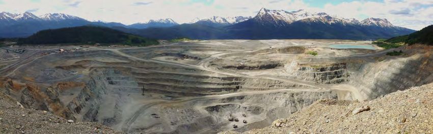
Kyba

  Table 2. Proposed mines and exploration projects, Eskay-Stewart-Anyox area.

  Property       Proponent          MINFILE Deposit Type Commodities 2014 Activities                                  Website

  Bow            Decade Resources 104B 132     Porphyry       Au            Diamond drilling (15 holes)               www.
                 Ltd.                                                                                                 decaderesources.ca
  Bronson        Snip Gold Corp.    104B 077   Porphyry       Au, Cu, Ag    Geology, Corporate                        www.snipgoldcorp.
                                                                                                                      com
  Brucejack      Pretium Resources 104B 193    Porphyry       Au, Ag        Diamond drilling (9,325 m, 7 holes,       www.pretivm.com
                 Inc.                                                       14 wedges) Geology, Geochemistry,
                                                                            Corporate, Underground development,
                                                                            environmental
  Columario      Argonaut           103I 077   Vein/Breccia   Au            Geochecmistry (rock chips)                www.
                 Exploration Inc.                                                                                     argonautexploration.
                                                                                                                      com
  Corey          Kenrich-Eskay      104B 240   porphyry       Au, Ag, Cu    Geology, Geochemistry                     www.eskaymining.
                 Mining Corp.                                                                                         com
  Del Norte      Teuton Resources 104A 176     Vein/Breccia   Au            Diamond drilling ( 2 holes) Geoology      www.teuton.com
                 Corp.                                                      Geochemistry, Corporate
  Dolly Varden Dolly Varden       103P 188     Vein/Breccia   Ag            Diamond drilling (5,280 m, 12 holes)      www.
               Silver Corporation                                           Geology, Geochemistry (2,500 soils),      dollyvarensilver.com
               Hecla Mining                                                 Geophysics (IP + EM, 10.9 line km, 2
               Company                                                      borehole IP + EM)
  Granduc        Castle Resources 104B 021     Massive        Cu, Ag, Au    Corporate                                 www.castleresources.
                 Inc.                          Sulphide                                                               com
  High           Teuton Resources              Vein/Breccia   Au            Diamond drilling                          www.teuton.com
                 Corporation
  Homestake      Homestake          103P 216   Vein/Breccia   Au, Ag, Zn    Diamond drilling (2,972 m, 6 holes),      www.agnicoeagle.
  Ridge          Resource                                                   Geology, Geochemistry                     com
                 Corporation
  Inel           Colorado           104B 113   Vein/Breccia   Au, Ag, Zn,   see KSP below                             www.
                 Resources Ltd./                              Cu                                                      coloradoresources.
                 Snip Gold Corp.                                                                                      com
                                                                                                                      www.skylinegold.
                                                                                                                      com
  King           Metallis Resources 104B 079   Porphyry       Cu, Au, Mo    Geology, Geochemistry                     www.
                 Inc.                                                                                                 metallisresources.
                                                                                                                      com
  KSM            Seabridge Gold     104B 103   Porphyry       Au, Cu, Ag,   Diamond drilling (29,508 m, 29 holes),    www.seabridgegold.
                 Inc.                                         Mo            Geology, Geochemistry, Geophysics,        net
                                                                            Corporate
  KSP            Colorado           104B 138   Porphyry       Au, Cu        Diamond drilling (791 m, 6 holes)         www.
                 Resources Ltd.                                             Geophysics (mag, 600 line km),            coloradoresources.
                                                                            Geology, Geochemistry (soils,             com
                                                                            rock chips)
  Premier        Ascot Resources    104B 054   Vein/Breccia   Au            Diamond drilling (36,672 m, 169 holes),   www.ascotresources.
                 Ltd.                                                       Geology, Geochemistry                     ca
  Red Mountain IDM Mining Ltd. 103P 086        Vein/Breccia   Au            Diamond drilling (3,630 m, 12 holes),     www.idmmining.
                                                                            Geology, Geochemistry, Corporate          com
  Snowfield      Pretium Resources 104B 179    Porphyry       Au, Cu, Mo    Corporate                                 www.pretivm.com
                 Inc.
  Tide North     Auramex            104B 252   Massive        Au            Diamond drilling (501 m, 1 hole),         www.auramex.com
                 Resources Corp.               Sulphide                     Geology
  Torbrit        Dolly Varden       103P 191   Sedimentary Ag, Pb, Zn,      see Dolly Varden                          www.
                 Silver Corporation            Replacement Cu, Au                                                     dollyvarensilver.com
  Treaty Creek   American Creek     104B 078   Vein/Breccia   Au, Ag, Cu    Corporate                                 www.americancreek.
                 Resources Ltd.                                                                                       com

                                                                    102
Exploration and Mining in British Columbia, 2014. British Columbia Ministry of Energy and Mines, British Columbia Geological Survey IC 2015-2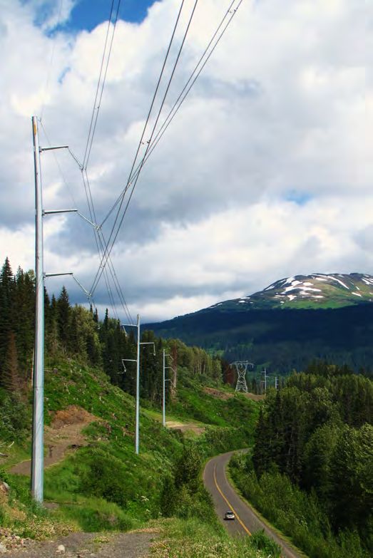
Kyba

  Table 3. Highlight drilling results from KSM.

  Zone                      Hole ID                   From (m)      To (m)             Width (m)     Au (g/t)      Cu (%)        Ag (g/t)

  Iron cap Lower Zone       IC-14-053                 488.4         1002.4             514           0.68          0.3           5.2
                            IC-14-054A                322.4         832.5              510.1         0.41          0.28          10.5
                            IC-14-054A                604.4         872                267.6         0.39          0.23          4.8
                            IC-14-055                 257.5         624.3              366.8         0.59          0.17          2.5
                            IC-14-057                 176           600.2              424.2         0.4           0.22          4
                            IC-14-058                 5.9           802                796.1         0.39          0.22          4
                            IC-14-059                 178.7         771.4              592.7         1.14          0.37          3.7
                            IC-14-060                 124           525.3              401.3         0.47          0.17          8
                            IC-14-061                 431.4         794.4              363           0.38          0.28          6.8
  Deep Kerr                 K-14-28C                  900           1257.4             357.4         0.5           0.63          1.9
                            K-14-34A                  871.4         1608.4             737           0.36          0.59         1.1
                            K-14-39                   945.4         1197.4             252           0.55          0.69          1.4
                            K-14-45                   400.4         1123               722.6         0.36          0.59          2.6

                                                                               or contained in a zone of bulk low-grade mineralization up to
                                                                               several grams per tonne gold. Bulk low-grade mineralization
                                                                               tends to be associated with disseminated anhedral pyrite. High-
                                                                               grade gold-silver electrum mineralization is hosted in deformed
                                                                               transitional epithermal stockwork veins up stratigraphy from
                                                                               several large and slightly older porphyry deposits; the multi-
                                                                               phase Mitchell intrusions (Pretium Resources, 2015).
                                                                                  Ascot Resources Ltd. continued drilling at the Premier
                                                                               and Big Missouri gold projects 20 km north-northwest of
                                                                               Stewart. Drilling of a multiphase program completed in 2014
                                                                               (36,672 m in 169 holes) identified a new area of mineralization
                                                                               at Big Missouri before focusing on zones around Premier.
                                                                               Broad zones of elevated (>1 g/t eAu) mineralization support
  Fig. 10. Fine-grained electrum and pyrite in quartz-carbonate matrix
                                                                               the resource estimate released in March. Indicated Resources
  from the Brucejack Cleopatra vein.                                           total 93.5 Mt grading 0.82 g/t Au and 6.9 g/t Ag. Additional
                                                                               Inferred Resources total 79.2 Mt grading 0.59 g/t Au and 7.2
  specifics including gold price, increased reserves, and higher               g/t Ag. Both estimates used a 0.3 eAu cut-off and include the
  gold grades. Results remained positive for the proposed 2,700                Dilworth, Martha Ellen and Big Missouri deposits. The
  tonne per day milling operation forecasted to operate for 18                 Premier and surrounding deposits are hosted in Hazelton
  years and produce 226 tonnes (7.27 million ounces) of gold.                  Group andesite tuffs, lapilli tuffs, and flows. Dikes of Premier
     Brucejack is on the eastern limb of the northerly trending                porphyry are spatially associated with most mineralized zones
  McTagg anticlinorium, a regional scale, mid-Cretaceous                       and are interpreted to be ring dikes to a vent flanking a larger
  structural culmination in the western Skeena fold belt (e.g.,                volcanic center in the Big Missouri area (Alldrick, 1993).
  Nelson and Kyba, 2014). The Brucejack property is underlain                     In April, the Red Mountain gold project (Fig. 12) was optioned
  by volcanosedimentary rocks of the Stuhini Group (Triassic)                  from Seabridge Gold Inc. to Revolution Resources Corp. who
  that are unconformably overlain by the Hazleton Group (Late                  changed their name to IDM Mining Ltd. An updated resource
  Triassic-Jurassic, Fig. 11) and Bowser Lake Group cover rocks.               estimate and Preliminary Economic Assessment completed in
  These rocks are cut by the Brucejack fault, which is interpreted             July indicated favorable economics to pursue a 1,000 tonne
  to have had a long history of reactivation (Nelson and Kyba,                 per day seasonal underground mine. A Project Description was
  2014). Alteration is mainly pervasive quartz-sericite-pyrite                 submitted to the British Columbia Environment Assessment
  replacement in zones several hundred metres wide and several                 office for review. IDM completed 12 drill holes (3,630 m)
  kilometres long. Most of the five mineral resources (West Zone,              testing mineralization beyond known resources at the Marc,
  Valley of the Kings, Bridge Zone, Gossan Hill, and Shore                     AV, and JW zones. Drilling and surface results confirm gold
  Zone) are in the intensely altered zones and associated with                 mineralization, most notably 138 m grading 1.41 g/t Au from
  vein-stockworks. High-grade zones are either on the margins                  64 m depth in drill hole MC14-03. Retreat of the Bitter Creek

                                                                         103
Exploration and Mining in British Columbia, 2014. British Columbia Ministry of Energy and Mines, British Columbia Geological Survey IC 2015-2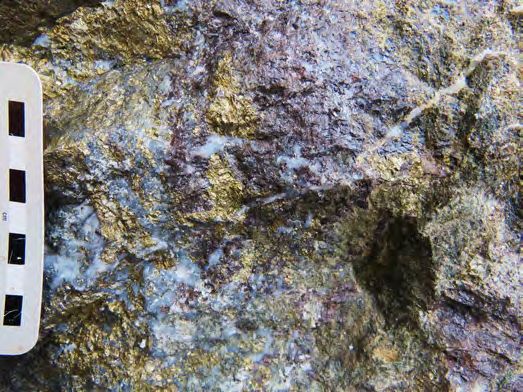
Kyba

  Table 4. Highlight drilling results from Brucejack.
  Zone                        Hole ID                     From (m)       To (m)           Width (m)           Au (g/t)      Ag (g/t)
  Valley of the Kings         SU-632-W4                   78.76          80.86            2.1                 2415.17       353.43
                              SU-644-W1                   113            135.1            22.1                26.14         10.59
                              SU-644-W2                   169.75         174.2            4.45                515.24        90.48

  Fig. 11. Looking north, Hazelton Group conglomerate (left) unconformably overlying folded Stuhini Group argillite and sandstone. Unconformity
  is marked by white dashed line. Gossanous backdrop is Sulpurets ridge, foreground drops off to Brucejack Creek.

                                                                            and geophysical anomalies along the north-northwest regional
                                                                            structural trend hosting the Torbrit mine. Seven of the twelve
                                                                            drill holes returned intersections including 9.01 m grading
                                                                            1,496 g/t Ag from hole DV14010 from the Kitsol vein. Drilling
                                                                            results also confirmed a direct correlation between silver
                                                                            mineralization and a 7.2 km-long potassium anomaly, which
                                                                            will be used to guide 2015 exploration.
                                                                               Homestake Resource Corporation resumed 100% ownership
                                                                            of the Homestake Ridge silver-gold project. Agnico Eagle
                                                                            Mines Limited returned the project after their second year
                                                                            of exploration focussed on the Slide target. Drilling totalled
                                                                            2,972 m in six holes which extended the Slide zone to a strike
                                                                            length of 800 m. Best results include 4.5 m grading 144 g/t Ag
                                                                            from drill hole HR14-264. Metal zonation patterns at the Slide
                                                                            zone appear analogous to the neighboring Main Homestake
                                                                            Silver deposit, which contains a deeper, gold enriched zone.
  Fig. 12. Looking northeast over IDM Mining’s Red Mountain gold            Future drilling aims to test this deeper target at the Slide zone.
  project. Photo courtesy of IDM Mining.                                    The company also continued target generation work on their
                                                                            optioned Kinskuch Property. The cumulative 625 km2 mineral
  glacier and Cambria ice fields revealed new showings up to 500            claims host 58 MINFILE occurrences and have been divided
  m away from historic workings.                                            into four target areas: Esperenza, FH, Illiance and Kitgold.
                                                                               Teuton Resources Corp. completed five drill holes at their
  4.2. Exploration projects                                                 Del Norte property, 25 km east-northeast of Stewart. Results
                                                                            indicate porphyry copper-gold mineralization (Fig. 13) with a
     Dolly Varden Silver Corporation partnered with Hecla
                                                                            highlight intercept from drill hole D14-03 returning 12.19 m
  Mining Company to complete multiple surveys and 5,280 m
                                                                            grading 0.92 g/t Au, 0.15% Cu and 3.07 g/t Ag. Teuton also
  of drilling near the past producing Dolly Varden, Torbrit                 completed sixteen drill holes at their High project, immediately
  and Wolf high-grade silver mines 45 km southeast of Stewart.              south of Pretium Resources Brucejack project. Results
  Exploration concepts focused on intersections of prospective              confirmed gold-silver mineralization over widths up to 15 m.
  stratigraphy with altered and mineralized structures. Twelve                 Teuton and American Creek Resources Ltd. continued a
  drill holes spaced over 2 km tested multi-element geochemical             legal dispute over ownership of the Treaty Creek project area

                                                                      104
Exploration and Mining in British Columbia, 2014. British Columbia Ministry of Energy and Mines, British Columbia Geological Survey IC 2015-2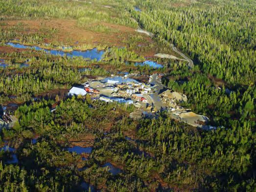
Kyba

                                                                             anomaly identified in 2013. Groundwork included geochemical
                                                                             sampling, prospecting, and geological mapping.
                                                                                Eskay Mining Corp. conducted reconnaissance scale
                                                                             prospecting and mapping at their Corey property between
                                                                             Eskay Creek and KSM.
                                                                                Colorado Resources Ltd. partnered with SnipGold
                                                                             Corporation to explore their KSP (Khyber, Sericite and Pins)
                                                                             property in the Bronson trend (Fig. 14; Metcalfe and Moors,
                                                                             1992), which includes the past-producing Snip and Johnny
                                                                             Mountain gold mines. Extensive visible alteration (Fig. 14) led
  Fig. 13. Chalcopyrite-bearing drill core from Teuton Resources Del         company geologists to compile legacy data and consolidate a
  Norte project. Photo courtesy of Teuton Resources.
                                                                             ground position amenable to testing kilometre-scale deposit
                                                                             models. Analysis of 684 rock and 1,247 soil samples and 600
  northeast of Seabridge Gold’s KSM project. Compilation of
  geotechnical drilling and geophysics completed by Seabridge                line km of airborne magnetic surveys led to further sampling
  for the Mitchell-Treaty twin tunnel access to KSM has                      and late-season drilling, including 791 m in six holes.
  highlighted areas for further testing.                                     Best results include 101.4 m grading 1.16 g/t Au (drill hole
    Decade Resources Ltd. completed drill testing at the Bow                 KSP14-003) and a 34 m interval grading 2.98 g/t Au. New
  property 35 km north-northwest of Stewart and adjacent to                  geological mapping now covers over 50 square kilometres and
  the past producing Scottie Gold mine. Early season grab                    indicates several untested zones. British Columbia Geological
  sampling returned gold values up to 3,418 g/t Au and led to                Survey mapping indicates that the structural and stratigraphic
  follow-up drilling. Best results were returned from drill-hole             framework may be analogous to the KSM mineralized system
  DDH-14-Bow-1; 49.6 m grading 15.25 g/t Au and DDH-14-                      (Kyba and Nelson, 2015).
  Bow-2: 12.66 m grading 38.43 g/t Au. Fifteen drill holes were
  completed to test high-grade gold mineralization hosted in the             5. Stikine Arch
  Blueberry vein structure and the Sixties zone.                               The Stikine Arch includes parts of the Stikine, Cache Creek,
    Auromex Resource Corp. and Pretium Resources Inc.                        and Quesnel terranes and is cut by regional east-west trending
  completed a single 500 m hole at the Tide North prospect. The              faults (Fig. 1). The most common metal prospects are high-
  hole tested a deep conductivity target interpreted to be in the            potassium, calc-alkalic porphyry style deposits similar to Red
  same stratigraphic units as Eskay Creek. Results found a thick             Chris (Table 5). Late Triassic to Early Jurassic copper-gold
  succession of foliated carbonaceous sedimentary rocks with                 bearing stocks intrude Stuhini and Hazelton Group rocks.
  minor sulphides.
    Metallis Resources Inc. completed a reconnaissance program               5.1. Mine development
  at the King property, immediately west of the KSM project.                   Red Chris Development Company Ltd. (Imperial Metals
  Exploration aimed to ground truth the King VTEM geophysical                Corporation) is in the final stages of construction at the Red

  Fig. 14. Looking northwest along the Sky fault system (Kyba and Nelson, 2015) from Sericite ridge towards Pyramid, Khyber Pass and Johnny
  Mountain at Colorado Resources KSP project.

                                                                       105
Exploration and Mining in British Columbia, 2014. British Columbia Ministry of Energy and Mines, British Columbia Geological Survey IC 2015-2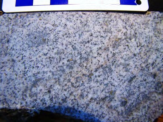
Kyba

  Table 5. Mine development, proposed mines, and exploration projects, Stikine Arch.
  Property      Proponent                   MINFILE Deposit Type Commodities 2014 Activities                         Website
  Boulder Gold Pacific Bay Minerals Ltd. 104I 004      Vein/Breccia Au            Diamond drilling (246 m, 1 hole), www.
                                                                                  Geology,Geochemistryorporate       pacificbayminerlas.
                                                                                                                     com
  Castle        Kaizen Discovery Inc.       104G 076 Porphyry      Au, Cu, Mo,    Geology, Corporate                 www.kaizendiscovery.
                                                                   Ag                                                com
  DOK           Boxxer Gold Corp.           104G 043 Porphyry      Cu, Au         Diamond drilling (834.9 m, 2       www.boxxergold.com
                                                                                  holes), Geology, Geochemistry
  Eaglehead     Carmax Explorations Ltd. 104I 008      Porphyry    Cu, Mo         Diamond drilling (2264.22 m, 4     www.carmaxex.com
                                                                                  holes), Geology, Geochemistry
  Eldorado      Colorado Resources Ltd. 104H 026 Porphyry          Au, Cu         Diamond drilling (892 m, 4 holes), coloradoresources.
                                                                                  Geology, Geochemistry              com
  Galore Creek Galore Creek Mining    104G 090 Porphyry            Cu, Au         Corporate, Environmental           www.gcmc.ca
               Corporation (Teck
               Resources Limited/
               NOVAGOLD Resources
               Inc.
  GJ           Teck Resources Limited 104G 034 Porphyry            Cu, Au         Corporate, Geology, Geochemistry www.ngexresources.
                                                                                                                   com
  Grizzly       Garibaldi Resources Inc. 104G 079 Porphyry         Cu, Au         Geology, Geochemistry, Corporate www.
                                                                                                                   garibaldiresources.
                                                                                                                   com
  Hat           Doubleview Capital Corp. 104J 015      Porphyry    Cu, Au         Diamond drilling (2,831, m, 7    www.doubleview.ca
                                                                                  holes), Geology, Geophysics
  Kutcho Creek Capstone Mining Corp.        104I 060   Massive     Cu, Zn, Ag,    Corporate                        www.capstonemining.
                                                       Sulphide    Au                                              com
  Kutcho Jade Continental Jade Ltd.         104I 078   IM_Rock     Jade           Mining                           www.jademine.com
  Metla         Clive Aspinall              104K 113 Porphyry      Au             Corporate
  Newmont       Romios Gold Resources       104B 281 Skarn         Au, Ag, Zn     Geophysics ( ZTEM, 372 line km) www.romios.com
  Lake          Inc.                                                              Geology, Geochemistry (314 Rock
                                                                                  chips)
  North ROK     Colorado Resources Ltd. 104H 035 Porphyry          Cu, Au         Diamond drilling (2,191 m, 5     www.
                                                                                  holes), Geology,                 coloradoresources.
                                                                                                                   com
  Pyramid       Gold Jubilee apital Corp.              Porphyry    Cu, Au         Geophysics (IP), Geology,
                                                                                  Geochemistry
  RCN           Serengeti Resources Inc.               Porphyry    Cu, Au         Geology, Geochemistry,           www.
                                                                                  Geophysics (IP)                  serengetiresources.
                                                                                                                   com
  Red Chris    Red Chris Development 104H 005 Porphyry             Cu, Au         Mine Construction, Environmental www.imperialmetals.
               Company Ltd. (Imperial                                                                              com
               Metals Corporation)
  ROK          Oz Minerals optioned     104H 012 Porphyry          Mo, Cu         Diamond drilling (842.15 m, 2       www.
               from Firesteel Resources                                           holes), IP (44.85 line km), Geology firesteelresources.com
               Inc.
  Schaft Creek Teck Resources Limited 104G 015 Porphyry            Cu, Mo, Au,    Geology                            www.teck .com
                                                                   Ag
  Sheslay       Prosper Gold Corp.          104J 035   Porphyry    Cu, Au         Diamond drilling (6,221.5 m, 19    www.prospergoldcorp.
                                                                                  holes), Geology, Geochemistry      com
  Spectrum      Skeena Resources Limited 104G 036 Vein/Breccia Au                 Diamond drilling (1,940 m, 9       www.skeenaresources.
                                                                                  holes), Geology, Geochemistry      com
  Summit        Pistol Bay Mining Inc./     104H 015 Porphyry      Cu, Au         Geology, Geochemistry,             www.vegamininginc.
                Vega Mining Inc.                                                                                     com
  Tanzilla      Kaizen Discovery Inc.       104I 023   Porphyry    Cu, Mo         Diamond drilling (1,386 m, 5       www.kaizendiscovery.
                                                                                  holes), Geology, Geochemistry,     com
                                                                                  Corporate
  Tatogga Lake New Chris Minerals Ltd. 104G 166 Porphyry           Cu, Mo         Geology, Geochemistry,
                                                                                  Geophysics (IP)
  Turnagain     Hard Creek Nickel Corp. 104I 119       Magmatic    Ni, Co, Pt, Pd Corporate                          www.hardcreeknickel.
                                                                                                                     com/

                                                                    106
Exploration and Mining in British Columbia, 2014. British Columbia Ministry of Energy and Mines, British Columbia Geological Survey IC 2015-2
Kyba
Chris copper-gold project 80 km south of Dease Lake. The
Northwest Transmission line (Fig. 15) now connects the
project to a 287 KV grid-based power originating near Terrace.
Imperial constructed the 93 km extension from Bob Quinn to
the project and sold it to BC Hydro in late December for $52
million. Ore taken from the Main and East zones (Fig. 16), is
being crushed and stockpiled in preparation for mill equipment
being commissioned. Before milling can proceed, Red Chris
needs an Environmental Management Act permit to discharge
tailings. Because of the tailings dam breach and resulting
flood at the Mount Polley mine, also owned by Imperial,
a third party review of the tailings impoundment area made
recommendations to be integrated into the design. Capital costs
have increased to total $643M for the completion of the 30,000
tonne per day mine. The expected mine life is 28 years.
Fig. 16. The first bench at the East Zone, Red Chris copper-gold mine.
5.2. Proposed mines
Teck Resources Limited re-logged over 16,867 m of
historic drill core at the Schaft Creek copper-gold-silver report. Teck owns 75% of the project and Copper Fox Metals
molybdenum deposit. Ongoing metallurgical, geotechnical, Inc. retains 25%. Teck and Novagold Resources Inc. completed
little more than basic monitoring and maintenance at the
and environmental studies will enhance the 2013 feasibility
Galore Creek gold-copper deposit. Capstone Mining Corp.
continued to maintain an airstrip and camp at their Kutcho
Creek massive sulphide project, 100 km east of Dease Lake.
5.3. Exploration projects
Oz Minerals Limited returned the ROK-Coyote copper-
gold project to Firesteel Resources Inc. after the exploration
program was interrupted by protests. Drill targets generated
from overlapping IP and magnetic anomalies were tested
with two holes totalling 842.15 m. Best results were returned
from drill hole DD14RK006; 109.1 m grading 0.11 g/t Au and
0.05% Cu from 383 m depth. Colorado Resources Ltd. grew
their North ROK copper gold project from a single rock chip
sample collected during a British Columbia Geological Survey
regional mapping project (Ash, 1997) to a 142.3 Mt Inferred
Resource estimate grading 0.22% Cu and 0.26 g/t Au in nine
months. The company returned in early 2014 and demonstrated
continuity at depth and a new zone, West Mabon. Drilling
totalled 2,191 m in five holes. Colorado also completed 892 m
of drilling at the Eldorado prospect northeast along trend from
the Red Chris deposit. Despite broad intersections of weak
copper-gold mineralization, Colorado returned the property to
Sunrise Resources Ltd.
New Chris Minerals Ltd. completed reconnaissance surveys at
their Tatogga Lake project area. Over one thousand combined
soil and rock samples were collected in conjunction with a
ground IP survey and geological mapping. New showings were
discovered along the ‘Northern Lights’ shear zone (Fig. 17).
Skeena Resources Ltd. completed a late-season drill program at
the Spectrum gold project 85 km south of Dease Lake, on the
eastern flank of Mt Edziza. Nine drill holes totalling 1,950 m
confirmed historical gold values and proved depth continuity
well below historical drilling. The best intersection returned 27
Fig. 15. Northwest Transmission Line near Bell 2. m grading 10.63 g/t Au from 106 m depth in drill hole 14-SP-
107
Exploration and Mining in British Columbia, 2014. British Columbia Ministry of Energy and Mines, British Columbia Geological Survey IC 2015-2Kyba
Fig. 18. Traversing across the strongly QSP altered Silica Ridge.
Detailed studies of the clay alteration mineralogy helped define drill
targets, which led to the discovery of a copper-gold-molybdenite
bearing porphyry and high sulphidation system.
included four drill holes totalling 2,264 m and a TITAN 24
geophysical survey. Results of the 18-line km geophysical
survey identified two areas of high chargeability over a 5.6 km
strike length. Drilling targeted both the East zone and Bornite
zone and intersected copper-molybdenum-gold-mineralization
(Fig. 19) reflecting similar grades to those in a 2012 resource
estimate. Drilling proved the mineralized system extends
deeper than previously known.
Pacific Bay Minerals Ltd. completed a single 246 m drill
hole at Boulder Gold 60 km east of Dease Lake. Boulder City
has a rich placer gold history but a bedrock source has never
Fig. 17. Chlorite shear hosted quartz-carbonate-chalcopyrite- been fully investigated. Drilling results have returned visual
malachite-azurite veining at the Northern Lights showing, New Chris sulphide mineralization with assays pending.
Mineral’s Tatogga Lake project. Gold Jubilee Capital Corp. discovered a new copper-gold-
004.
Serengeti Resources Inc. completed a program at their RCN
property to follow up 2013 results. Groundwork included an IP
survey and geochemical rock and soil sampling. Results of the
2014 program included outcrop samples up to 0.97% Cu and
1.38 g/t Au and open-ended chargeability highs.
Kaizen Discovery Inc. (formerly West Cirque Resources)
proved porphyry and high-sulphidation style copper-gold-
molybdenum mineralization at Tanzilla, 23 km southeast of
Dease Lake (Fig. 18). The 2 x 1.5 km changeability anomaly
underlying Silica ridge was tested this year with three diamond
drill holes, which returned copper-gold grades of up to 0.13%
Mo and 0.148 g/t Au. Drill hole TZ 14-05 targeted the central
chargeability high and intersected strong pervasive, silica and
advanced argillic altered hydrothermal breccias containing
disseminated and vein hosted covellite, chalcopyrite, enargite,
and molybdenite. Fig. 19. Chalcopyrite- and bornite-bearing quartz vein in phyllic
Carmax Mining Corp. resumed exploration at the Eaglehead altered granodiorite at Carmax Mining’s Eaglehead project. Photo by
copper-molybdenum-gold-silver porphyry. Ground work Bev Quist.
108
Exploration and Mining in British Columbia, 2014. British Columbia Ministry of Energy and Mines, British Columbia Geological Survey IC 2015-2Kyba
silver showing at Pyramid (Fig. 20) 50 km north of Dease
Lake. The 2014 work program included a 32.3 line km Volterra
3D IP survey and 722 combined geochemical soil, silt, and rock
samples. Widespread anomalous gold and copper values in
soils coincident with IP chargeability and resistivity anomalies
are guiding follow up work. The best hand sample returned
11.5 g/t Au, 7.0 g/t Ag and 0.08% Cu.
About 105 km west of Dease Lake, Prosper Gold Corp.
completed a drilling program at the Sheslay copper-gold
project, which was optioned from Firesteel Resources Inc.
Drilling totalled 6,221 m in twenty holes and aimed to expand
known mineralization. Results were consistent with historical
copper gold values (Fig. 21). The best results were from drill
hole S045: 106.98 m grading 0.77% Cu, 0.407 g/t Au and 1.02
g/t Ag.
Doubleview Capital Corp. continues exploration work Fig. 21. Outcrop sample of the chalcopyrite-bearing Sheslay diorite.
through the winter at the nearby Hat gold-copper porphyry
project 95 km west of Dease Lake. Over 7,000 m of drilling
in 22 holes was completed in 2013-2014. The Lisle zone has silver project. Visible chalcopyrite has been reported but not
received most of the drilling and returned the best intersections validated by analytical results.
(drill hole HAT-022; 404.2 m grading 0.25% Cu and 0.255 g/t Romios Gold Resources Inc. followed up on their 2013
Au from 43.4 m depth including 118.4 m grading 0.55% Cu copper-gold-silver porphyry related skarn discovery at
and 0.41 g/t Au). The deposit now extends along a strike length Burgundy Ridge with sampling and prospecting in the larger
of 962 m, and to a depth of 400 m. Newmont Lake project area. Rock chip samples (Fig. 22) were
collected of which 173 targeted Burgundy Ridge. The average
About 40 km northwest of Schaft Creek and 50 km southwest
from Burgundy Ridge returned 0.40% Cu, 0.48 g/t Au and 4.78
of Telegraph Creek, Boxxer Gold Corp. completed two drill
g/t Ag; the highest grades were in excess of 9% Cu, 52 g/t Au
holes totalling 834.9 m, on the DOK copper-gold-molybdenum-
and 171 g/t Ag. Prospecting nearly 2 km beyond Burgundy
ridge identified several zones of porphyry-related copper-
gold bearing skarns. Mineralization appears to be related to
megacrystic potassium feldspar syenite porphyry and diorite
porphyry dikes intruded into dolomitic limestones.
6. Skeena Arch
The Skeena Arch forms a topographic high separating the
Bowser and Netchako basins. The district contains numerous
Cretaceous and younger faults whose enveloping trend is
northeast, at a high angle to the general northwest Cordilleran
Fig. 20. Fracture-controlled mineralization in quartz-sericite-pyrite Fig. 22. Systematic sampling at Burgundy Ridge. Photo courtesy of
altered diorite at Pyramid. Photo by Dustin Perry. Romios Gold.
109
Exploration and Mining in British Columbia, 2014. British Columbia Ministry of Energy and Mines, British Columbia Geological Survey IC 2015-2Kyba
trend. Mineral deposits in the area include calc-alkalic was suspended in mid-August pending the outcome of the
porphyries, precious metal veins, and minor coal (Fig.1; Table Independent Expert Engineering Investigation and Review
6). Panel, which is investigating the tailings dam breach at Mt.
Polley.
6.1. Mine development
Avanti Mining Inc. (Alloy Corp Mining Inc. as of December 6.3. Exploration projects
1st) is working to reopen the past-producing Kitsault Goldreach Resources Ltd. continued drilling at their Ootsa
molybdenum- silver mine, 115 km north of Terrace. In June, copper-gold-silver molybdenum porphyry project about 6 km
the project received an amendment to an existing Mines Act south of the producing Huckleberry copper mine. Measured
permit and federal approval of their Environmental Assessment and Indicated Resources increased from 2013 results and now
application. These approvals allowed the company to begin total 153.9 Mt grading 0.21% Cu using a 0.20 eCu cut-off.
road and camp construction and infrastructure upgrades. Drilling in 2014 totalled 9,795 m in 20 drill holes (11 targeted
Also in June, the Nisga’a First Nation and the company known resource areas and 9 tested step out exploration targets).
successfully negotiated a Mine Benefits Agreement. Details of Goldreach also expanded their mineral claim holdings totalling
the agreement include a net smelter royalty of up to 2% (based over 71 km2 and added several known prospects to their
on prevailing molybdenum prices) and a resolution to all exploration inventory, including the Troitsa Peak gold-silver
outstanding litigation. A memorandum of understanding with prospect and the past-producing Captain silver mine.
the Wilp Luuxhon First Nation was also signed. Construction About 32 km southwest of Houston, Similco Mines Ltd.
activities are scheduled to continue throughout the winter, tested the Fenton Creek prospect with about 3,000 m of
focusing on upgrading the Nass River Bridge and a 150 bed diamond drilling in nine holes. Targets were generated from
construction camp. The mine plan outlines a 45,000 tonne 1,600 m of percussion drilling in 53 holes and deep penetrating
per day mill to be active for at least 14 years. Current Proven IP geophysics. Finlay Minerals Ltd. completed about 1,000 m of
plus Probable reserves total 226.3 Mt grading 0.083% Mo + drilling in 3 holes at their Silver Hope project, 35 km southeast
5.3 g/t Ag. The company plans to truck concentrate to Prince of Houston and surrounding the past producing Equity Silver
Rupert or Vancouver. Kitsault operated from 1967 to 1972 and Mine. Northern Abitibi Mining Corporation completed seven
again from 1981 to 1982, milling 13.4 Mt grading 0.101% trenches and 274 geochemical rock chip samples at the Ches
Mo. Molybdenite mineralization (Fig. 23) is primarily hosted porphyry project 80 km south of Burns Lake. Results indicate
in aplite dikes and banded quartz-molybdenite veins related a variably mineralized zinc-copper-tungsten skarn system
to diorite-quartz diorites of the Lime Creek intrusive complex over an area 1.5 x 0.5 km. A 1.5 m rockchip sample returned
(Eocene) that cut Jurassic greywackes and argillites of Bowser 1.25% Zn, 0.16% Cu and 0.12% WO3 (tungsten trioxide). KGE
Basin (Carter, 1974). Management Ltd. completed biogeochemical bark sampling
at the Boer property, a company completed an IP geophysical
6.2. Proposed mines survey at the CR prospect and Astorious Resources Ltd.
In February, Metal Mountain Resources Inc. submitted reported results of an IP survey at Babine.
an application for an amendment to their existing Mines Act
7. Atlin area
Permit to build a 250 tonne per day onsite mill at their Dome
The Atlin Area area, in the northwestern part of the Skeena
Mountain gold mine, 35 km east of Smithers. An Environmental
Region, is underlain by the Cache Creek, Stikine, and Yukon-
Assessment application of the Morrison copper-gold project
Tanana terranes (Fig. 1). The Stikine terrane hosts almost all of
was referred to the Minister of Environment in mid-July but
the active projects (Table 7), although the Cache Creek terrane
hosts some economic mineral deposits, most significantly
placer gold mined east of the community of Atlin. Deposit
types include Kuroko-type massive sulphides (e.g., Tulsequah
Chief), precious metal breccia pipes and porphyry (e.g., Thorn)
and epithermal veins (e.g., Engineer).
7.1. Proposed mines
In early December, Chieftain Metals Corp. filed an updated
feasibility study for their Tulsequah Chief high-grade copper-
lead-zinc-gold-silver VMS deposit about 100 km south of Atlin.
Rather than building a road between Atlin and the deposit, the
plan calls for conventional barging during five months of the
year, eliminating $125 million of pre-production capital costs.
Fig. 23. Sheeted quartz-molybdenite veins cutting Lime Creek The 1,100 tonne per day underground mine would operate for
intrusive complex quartz monzodiorite at Kitsault. at least 11 years on 4.4 Mt of reserves.
110
Exploration and Mining in British Columbia, 2014. British Columbia Ministry of Energy and Mines, British Columbia Geological Survey IC 2015-2Kyba
Table 6. Mine development, proposed mines, and exploration projects, Skeena Arch.
Property Proponent MINFILE Deposit Type Commodities 2014 Activities Website
Babine Astorius 093L 209 Porphyry Cu, Au Geophysics (IP) www.astoriusresources.
Resources Ltd. com
Big Onion Eagle Peak 093L 124 Porphyry Cu, Mo, Au, Ag Geology, Geochemistry www.
Resources Inc. eaglepeakresources.com
Boer KGE Porphyry Cu Geochemistry (biogeochem, till),
Management Geology
Ltd.
Ches Northern Abitibi 093F 042 Porphyry Mo, Cu, Zn, W 7 trenches, Geochecmistry (274 www.naminco.ca
Mining Corp. rock chips)
CR Wes Moll 093L 007 Porphyry Cu Geophysics (IP), Geology
Davidson Don Davidson 093L 110 Porphyry Mo Corporate
Deer Horn Deer Horn 093E 019 Vein/Breccia Au, Ag, Te Corporate www.deerhornmetals.
Metals Inc. com
Dome Metal Mountain 093L 022 Vein/Breccia Au, Ag Corporate www.
Resources Inc./ metalmountainresources.
Gavin Mines com
Ltd.
Emerald Glacier Lowprofile 093E 001 Vein/Breccia Zn, Ag, Pb, Cu, Geology, Geochemistry
Ventures Ltd. Au
Fenton Similco Mines 093L 248 Vein/Breccia Cu, Ag, Zn Diamond drilling (3,000 m,
Ltd. 9 holes), Percussion Drilling
(1,600 m, 53 holes) Geology,
Geochemistry, Geophysics (IP, 9
line km)
Fireweed Shamrock 093M 151 Sedimentary Ag Corporate www.shamrockresources.
Resources Inc. Replacement com
Hanson Lake John Chapman/ 093K 078 Porphyry Mo, Cu Geology, Geochemistry
Gerry Carlson
Huckleberry Huckleberry 093E 037 Porphyry Cu, Mo Geology, Geochemistry (soils) www.imperialmetals.
Mines Ltd. com
Kitsault Avanti Mining 103P 120 Porphyry Mo, Ag Corporate www.avantimining.com
Inc./Alloy Corp.
Mining Inc.
Lennac Lake Don MacIntyre 093L 190 Porphyry Cu, Mo Corporate
Morrison Pacific Booker 093M 007 Porphyry Cu Corporate www.pacificbooker.com
Minerals Inc.
Ootsa Goldreach 093E 105 Porphyry Cu, Au Diamond drilling, (9,795 m, 20 www.
Resources Ltd. holes), Geology, Geochemistry goldreachresources.com
(soils)
S2 Vale Porphyry Cu, Mo, Ag Geophysics, Geology, Geochemistrywww.vale.com
Silver Hope Finlay Minerals 093L 256 Vein/Breccia Ag, Cu Diamond drilling www.finlayminerals.com
Ltd.
Silver Queeen New Nadina 093L 002 Porphyry Cu, Mo Corporate www.nadina.com
Explorations
Limited
Suskwa Xander 093M 027 Porphyry Cu, Au Geophysics ( EM + Mag, 937 line
Resources Inc. km)
Yellow Giant Banks Island 103G 021 Vein/Breccia Au, Ag Diamond drilling www.banksislandgold.
Gold Ltd. com
111
Exploration and Mining in British Columbia, 2014. British Columbia Ministry of Energy and Mines, British Columbia Geological Survey IC 2015-2Kyba
Table 7. Proposed mines and exploration projects, Atlin area.
Property Proponent MINFILE Deposit Type Commodities 2014 Activities Website
Engineer BC Gold Corp. 104M 014 Vein/Breccia Au Geology, Corporate www.
bcgoldcorp.com
Golden Eagle Troymet Exploration Corp. 104M 044 Vein/Breccia Au Geology, Corporate, www.troymet.
Feasibility com
Tulsequah Chieftain Metals Inc. 104K 002 Massive Cu, Zn, Ag, Au Corporate www.
Chief Sulphide chieftainmetals.
com
Rohan Eagle Plains Resources Ltd./ 104M 032 Vein/Breccia Au Geology www.
Rosedale Resources Ltd. eagleplains.ca
Thorn Brixton Metals Corp. 104K 031 Vein/Breccia Au, Cu Diamond drilling (1,287 m, www.
8 holes), Geology, brixtonmetals.
Geochemistry, Corporate com
7.2. Exploration projects 8. Good Hope area
Brixton Metals Corporation continued exploration at the The Good Hope area, in the northeastern part of the Skeena
Thorn project 125 km south-southeast of Atlin. The project Region, is underlain by the Qusenell, Yukon-Tanana, and Slide
contains multiple targets including high-grade silver-gold-lead- Mountain terranes and the Cassiar platform of ancestral North
zinc diatreme breccias, high-grade veins, porphyry copper- America (Fig. 1). Economic mineral deposits include manto
gold, and intrusion-related sediment-hosted gold. In 2014 the replacement at Silvertip, porphyry molybdenum at Storie, and
company completed eight drill holes totalling 1,287 m divided nephrite jade at Cassiar (Table 8).
between the Glenfiddich zone (464 m in 4 holes) and the
Outlaw zone (823 m in 4 holes). Results from the Outlaw zone 8.1. Proposed mines
discovered 59.65 m grading 1.15 g/t Au and 5.64 g/t Ag from JDS Silver Inc. has repaired the 26 km access road to the
76 m depth in drill hole THN14-128. Mineralization is hosted Silvertip high-grade silver manto deposit about 95 km west
in siltstone but is thought to be intrusion related. Brixton filed of Watson Lake. A concentrator has been purchased and is
a maiden Inferred Resource estimate for the combined Oban, currently being stored in Watson Lake. The mine is proposed
Talisker and Glenfiddich zones. Total estimated in-pit and to be a 74,000 tonne per year underground operation. Limited
underground inferred resources total 7.4 Mt grading 35.54 g/t mine site preparation work was completed in 2014 and the
Ag, 0.51 g/t Au, 0.13 % Cu, 0.32 % Pb and 0.59% Zn. Grades Mines Act Permit review began in November.
and cut offs vary between deposits. Grassroots prospecting,
mapping, and geochemical sampling programs were completed 8.2. Exploration projects
by Eagle Plains Resources Ltd. at the Rohan property and BC Moly Ltd., formerly Columbia Yukon Exploration Inc.,
by Troymet Exploration Corp. at the Golden Eagle. BCGold filed an updated resource estimate for their Storie molybdenum
Corp. completed limited corporate activities to source financing project 85 km north of Dease Lake. Measured plus Indicated
for their Engineer gold mine 31 km west-southwest of Atlin. estimates total 117 Mt grading 0.068 % Mo using a 0.03 % Mo
Discussions were unsuccessful to source financing for a 4,000 cut off. Pacific Bay Minerals Ltd. completed a 409 m diamond
tonne bulk sample. drilling program at the Haskins-Reed polymetallic skarn
Table 8. Proposed mines and exploration projects, Good Hope area.
Property Proponent MINFILE Deposit Type Commodities 2014 Activities Website
Cassiar Jade Cassiar Mountain Jade IM_Rock Jade Mining www.jadecity.com
Cassiar Jade Cassiar Jade Contracting 104P 005 IM_Rock Jade Mining www.
cassiarjadecontracting.
com
Haskins Reed Pacific Bay Minerals Ltd. 104P 021 Skarn Zn, Pb, Ag, Mo Diamond drilling (409 m, 6 www.
holes), Geology, Geochemistry pacificbayminerals.com
Silvertip JDS Silver Inc. 104O 038 Sedimentary Ag, Pb, Zn, Au Access road repair, corporate www.jdsmining.ca
Replacement
Storie BC Moly Ltd. 104P 069 Porphyry Mo Corporate www.columbiayukon.
com
Fireside Fireside Minerals Ltd. 094M 003 IM_Rock Barite Diamond drilling (2242 m), www.firesideminerals.
mining com
112
Exploration and Mining in British Columbia, 2014. British Columbia Ministry of Energy and Mines, British Columbia Geological Survey IC 2015-2Kyba
Table 9. Proposed mines, Bowser Basin.
Property Proponent MINFILE Deposit Type Commodities 2014 Activities Website
Arctos Fortune Minerals 104H 022 Metallurgical Anthracite Environmental www.fortuneminerals.
Limited coal com
Groundhog Atrum Coal 104A 078 Metallurgical Anthracite Diamond drilling, (10,084 m, www.atrumcoal.com
coal 51 holes), Geophysics (seismic)
project 5 km north of Highway 37 and 105 km north of Dease Hicken (British Columbia Geological Survey). I benefitted
Lake. Results returned up to 48.6 m grading 2.31 % Zn from from discussions with Regional Geologists Paul Jago, Bruce
drillhole 14-02 targeting the Brett zone. Northcote, Fiona Katay, and Jim Britton.
9. Bowser Basin References cited
Jurassic to Cretaceous deltaic deposits of Bowser Basin Alldrick, D.J., 1993. Geology and metallogeny of the Stewart mining
camp, northwestern B.C. British Columbia Ministry of Energy
host the only significant anthracite deposits in Canada in the and Mines and Petroleum Resources, British Columbia Geological
Groundhog-Klappan Coalfield which, including Arctos and Survey Bulletin 85.
Groundhog, extends across the boundary between the Skeena Ash, C.H., MacDonald, R.J.W., and Friedman, R.M., 1997.
and Omineca regions (Fig. 1; Table 9; British Columbia Stratigraphy of the Tatogga Lake area, northwestern British
Geological Survey, 2015). The Government of British Columbia Columbia (NTS 104H, 12, 13; 104G/9, 16. In: Geological
Fieldwork 1996, British Columbia Ministry of Energy, Mines and
has extended the deferral of issuing new coal licences in the Petroleum Resources, British Columbia Geological Survey Paper
Klappan area for an additional year, ending in December 2015. 1997-1, pp. 283-290.
Existing coal licences are not affected. British Columbia Geological Survey, 2015. British Columbia coal
industry overview 2014. British Columbia Geological Survey
Information Circular 2015-3, 14 p.
9.1. Proposed mines Carter, N.C., 1974. Geology and Geochronology of Porphyry Copper
Atrum Coal continued advancing the Groundhog ultra-high and Molybdenum Deposits in West-Central British Columbia:
rank anthracite coal project toward an underground bulk sample. Unpublished PhD thesis, University of British Columbia.
The project area is 150 km northeast of Stewart. Drilling in 2014 Febbo, G.E., Kennedy, L.A., Savell, M., Creaser, R.A., Friedman,
R.M., 2015. Geology of the Mitchell Au-Cu-Ag-Mo porphyry
included 41 exploration holes and 10 hydrological monitoring
deposit, Northwestern British Columbia. In: Geological Fieldwork
holes totalling 10,084 m. Trenching, environmental baseline 2014, British Columbia Ministry of Energy and Mines, British
monitoring, and site planning have positioned the project Columbia Geological Survey Paper 2015-1, in press.
to excavate a bulk sample in early 2015. A supplementary Kyba, J. and Nelson, J.L., 2015. Stratigraphic and tectonic
Pre-Feasibility Study details a 5.4 Mt/ year run-of-mine framework of the Khyber-Sericite-Pins mineralized trend, lower
Iskut River, northwest British Columbia. In: Geological Fieldwork
underground operation for 38 years for the Groundhog North 2014, British Columbia Ministry of Energy and Mines, British
deposit, which contains an estimated 609 Mt. The feasibility Columbia Geological Survey Paper 2015-1, in press.
also proposes a multi-mine plan once the initial Groundhog Logan, J.M., and Mihalynuk, M.G., 2014. Tectonic controls on Early
North mine is operational. A project-wide JORC compliant Mesozoic paired alkaline porphyry deposit belts (Cu-Au ± Ag-
Measured + Indicated + Inferred resource estimate totals 1,567 Pt-Pd-Mo) within the Canadian Cordillera. Economic Geology,
Mt. Fortune Minerals Limited completed minimal groundwork 109, 827-858.
Marsden, H., and Thorkelson, D.J. 1992. Geology of the Hazelton
on the Arctos anthracite project jointly owned with POSCAN. Volcanic Belt in British Columbia: Implications for the Early to
Plans to conduct baseline work were put on hold as no new Middle Jurassic Evolution of Stikinia. Tectonics, 11, 1266 – 1287.
permits were issued in the Klappan Strategic Initiative Area. Metcalfe, P. and Moors, J.G. 1993. Refinement and local correlation
of the upper Snippaker Ridge section, Iskut River area, B.C.
(104B/10W and 11E). In: Geological Fieldwork 1992, British
Acknowledgments
Columbia Ministry of Energy, Mines and Petroleum Resources,
This report was made possible by the cooperation of Paper 1993-1, pp. 335-340.
companies operating in northwestern British Columbia, and I Nelson, J.L., Colpron, M., and Israel, S.K., 2013. The Cordillera of
thank mine staff, exploration geologists, and prospectors for British Columbia, Yukon, and Alaska: tectonics and metallogeny.
their generous hospitality, time and resources. Special gratitude In: Colpron, M., Bissig, T., Rusk, B., and Thompson, J.F.H.,
(Editors), Tectonics, Metallogeny, and Discovery - the North
to those who provided photographs and specifics about their American Cordillera and similar Accretionary settings. Society of
projects. The information in this report was summarized from Economic Geologists, Special Publication 17, pp. 53-109.
news releases, quarterly reports, MD&A reports, company Nelson, J., and Kyba, J., 2014. Structural and stratigraphic control of
websites, technical reports, Geological Survey of British porphyry and related mineralization in the Treaty Glacier – KSM
– Brucejack – Stewart trend of western Stikinia. In: Geological
Columbia publications, site visits and discussions with industry Fieldwork 2013, British Columbia Ministry of Energy and Mines,
professionals and personnel. Valuable assistance was provided British Columbia Geological Survey Paper 2014-1, pp. 111-140.
by the Smithers Mines Office staff, JoAnne Nelson, and Adrian Pretium Resources, 2015, Brucejack Geology Summary, www.
113
Exploration and Mining in British Columbia, 2014. British Columbia Ministry of Energy and Mines, British Columbia Geological Survey IC 2015-2You can also read