FILLING THE GAPS - CURVE | Carleton University Research ...
←
→
Page content transcription
If your browser does not render page correctly, please read the page content below
FILLING THE GAPS
                Reimagining Public Space as a Continuum

                                   by

                              Analiz Ochoa

A thesis submitted to the Faculty of Graduate and Post Doctoral Affairs in

        partial fulfillment of the requirements for the degree of

                         Master in Architecture

                           Carleton University

                        Ottawa, Ontario, Canada

                                 ©2021

                              Analiz Ochoa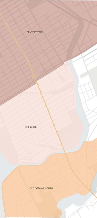
iii

ABSTRACT

There is a special joy found in the gaps of time and space

along the street—a possibility to dream, wonder, or suddenly

encounter the unexpected. Yet, these moments are rapidly

disappearing from the urban fabric as our streets undergo a

process of erosion. Like the river eating its bank, the public

realm is flaked away by traffic, congestion, and private

interests.

Who owns public space? To address this question, Filling the

Gaps reflects on the agency of the street and the different

actors that come into play. How can the notion of public and

private be reconceptualized to open-up urban spaces to

city-users? This thesis discovers the missed opportunities for
iv   Filling the Gaps

                        interactions with and within the city by observing Ottawa’s

                        street life. How can the street be transformed from a space

                        of passage alone to a space for connection and human

                        interaction? Four dismissed and unseen urban gaps are

                        chosen to explore the possibilities of publicness along the

                        street. How can a continuum streetscape for public life

                        emerge within the city? Through tactical interventions and

                        urban storytelling, the project reimagines a process where

                        urban dwellers renegotiate and extend the public realm’s

                        boundaries.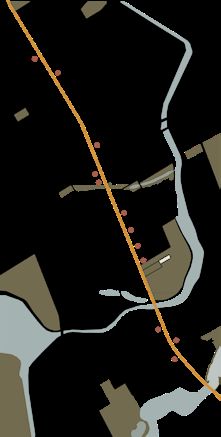
vii

ACKNOWLEDGEMENTS

To my mom and dad, for your guidance, for your unconditional

support and for providing me with all the tools I needed get

to the position I am in today. No words would ever explain

the gratitude I have for all the sacrifices both of you made.

To Rami, for being present in the day-to-day and proving

your constant support. Thank you for accompanying me to

explore the city and for all the thoughtful conversations that

developed along the way.

To my advisor, Federica Goffi, for your continual guidance

and kind words of reassurance through this remarkably
viii Filling the Gaps

                        difficult year. Your brilliant ideas and immense knowledge

                        helped and encouraged me to produce this project.

                        To all my family and friends, for all the help and motivation

                        you have given me through my career as a student.

                        To all the dwellers living along Bank Street, for allowing me

                        to document their day-to-day for this work.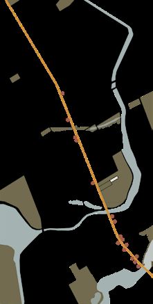
x                                                                                                                                     xi

TABLE OF CONTENTS

iii                 Abstract                                             PART THREE   STREETS OF TOMORROW
vii                 Acknowledgements
x                   Table of contents
xii                 List of figures                                      67           3.1 Emergence: A New City-User
                                                                         73           3.2 Tactical Urbanism: the Poblenau Superblock
1                   Prologue                                             79           3.3 Gap Transformation: Corner, Storefront, Alley,
3                   Introduction                                                      Parking Lot
                                                                         113          3.4 Reimagining Public Space as a Continuum in
                                                                                      Ottawa

PART ONE            DISMISSED SPACES

                                                                         125          Conclusion
13                  1.1 Life Along the Street
19                  1.2 The Street as the Foundation                     128          Endnotes
25                  1.3 The Street in the Time of Covid                  132          Bibliography

PART TWO            A WALK ALONG THE STREET

31                  2.1 The Street: Public Life on Bank Street
35                  2.2 The Three Neighbourhoods: Centertown, the
                    Glebe and Old Ottawa South
49                  2.3 Unpleasant Design
53                  2.4 The Gap Typologies: Corner, Storefront, Alley,
                    Parking Lot
xii                                                                                                                                                                                    xiii

LIST OF FIGURES

Figure 0.1 – Bächle in Freiburg, Germany, Photograph by David Sims, Soft City, (Washington:    PART TWO                      A WALK ALONG THE STREET
      Islander Press, 2019), 190.

Figure 0.2 - Karl Jilg/Swedish Road Administration, Illustration by Karl Jilg, accessed

      November      03,   2020,      https://www.vox.com/xpress/2014/11/18/7236471/cars-       Figure 2.1 – Bank Street’s neighbourhoods map, Illustration by Analiz Ochoa, March 2020.

      pedestrians-sidewalks-roads.                                                             Figure 2.2 - Bank Street along the Centertown neighborhood, Illustration by Analiz Ochoa,

                                                                                                  October 2020.

                                                                                               Figure 2.3 - Community street garden outside the Centertown United Church, Photograph
PART ONE                          DISMISSED SPACES                                                by Analiz Ochoa, October 2020.

                                                                                               Figure 2.4 - Empty lot enclosed by a metal fence between 136 and 152 Bank Street,

Figure 1.1 – Two boys along Bank Street and Fourth Avenue, Photograph by Analiz Ochoa,            Photograph by Analiz Ochoa, October 2020.

      October 2020.                                                                            Figure 2.5- Bank Street along the Glebe neighborhood, Illustration by Analiz Ochoa, October

Figure 1.2 – Model of Carlo Felice Theater, Genoa, Italy, Designed by Aldo Rossi, 1991,           2020.

      accessed November 03 2020, https://www.artsy.net/artwork/aldo-rossi-il-teatro-carlo-     Figure 2.6- The Patterson’s Creek Park intersection opens-up views of the park, Photograph

      felice-di-genova                                                                            by Analiz Ochoa, October 2020.

Figure 1.3 – Hester Street, Photograph by Maurice Branger, in Joseph Stomberg, “The            Figure 2.7 - Alley besides 745 Bank Street, Photograph by Analiz Ochoa, October 2020.

      forgotten history of how automakers invented the crime of ‘jaywalking,’” Vox, accessed   Figure 2.8- Bank Street along the the Old Ottawa South neighborhood, Illustration by Analiz

      January 05, 2021, https://www.vox.com/2015/1/15/7551873/jaywalking-history                  Ochoa, October 2020.

Figure 1.4 – A summer day in Byward Market Square, Photographed by Analiz Ochoa,               Figure 2.9 - Storefront at 1063 Bank Street, Photograph by Analiz Ochoa, November 2020.

      October 2020.                                                                            Figure 2.10 - Open corner between Belmont Street and Bank, where the Sri Chinmoy

Figure 1.5 – A fall day in Clarence Street and Byward Market Square, Photographed by              Meditation Centre has placed a cluster of benches and planters around a small

      Analiz Ochoa, October 2020.                                                                 monument, Photograph by Analiz Ochoa, October 2020.
xiv xv
Figure 2.11 - Bench on Bank Street and Waverly Street W, Photograph by Analiz Ochoa, 3, 2016, https://www.cbc.ca/news/canada/ottawa/ottawa-ncc-shuts-down-lemonade-
September 2020. stand-1.3662830.
Figure 2.12 – “Archisuits,” Artwork by Sarah Ross, accessed November 21, 2020. https:// Figure 3.2 – Poblenou superblock in its original, temporary-feeling form in 2016 Photograph
www.insecurespaces.net/archisuits.html. by BCNUEJ, in David Roberts, “Barcelona Wants to Build 500 Superblocks. Here’s What
Figure 2.13 - Gap along Bank Street between Henry’s and Alterna Savings, Photograph by It Learned from the First Ones.,” Vox, April 9, 2019, https://www.vox.com/energy-and-
Analiz Ochoa, September 2020. environment/2019/4/9/18273894/barcelona-urban-planning-superblocks-poblenou.
Figure 2.14 - A boy on the sidewalk, Photograph by Analiz Ochoa, September 2020. Figure 3.3 – Architecture on the edge of the Poblenou superblock, Photograph by
Figure 2.15 - Collection of corners along Bank Street, Photograph by Analiz Ochoa, Maysun, in David Roberts, “Barcelona Wants to Build 500 Superblocks. Here’s What It
September 2020. Learned from the First Ones.,” Vox, April 9, 2019, https://www.vox.com/energy-and-
Figure 2.16 - Collection of storefronts along Bank Street, Photograph by Analiz Ochoa, environment/2019/4/9/18273894/barcelona-urban-planning-superblocks-poblenou.
September 2020. Figure 3.4 – Map showing the gap interventions along Bank Street, Illustration by Analiz
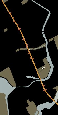
Figure 2.17- Collection of alleys along Bank Street, Photograph by Analiz Ochoa, September Ochoa, March 2020.
2020. Figure 3.5 - L’Esplanade building along the intersection of Bank Street and Laurier Avenue,
Figure 2.18 - Collection of surface parking lots along Bank Street, Photograph by Analiz Ottawa, Photograph by Analiz Ochoa, October 2020.
Ochoa, September 2020. Figure 3.6 – Corner intervention as a gathering plaza, Illustrated by Analiz Ochoa, January
2020.
Figure 3.7 – Transition of corner intervention, Illustrated by Analiz Ochoa, January 2020.
PART THREE STREETS OF TOMORROW Figure 3.8 - Wallack’s storefront at 231 Bank Street, Ottawa, Photograph by Analiz Ochoa,
October 2020.
Figure 3.1 - Eliza and Adela Andrew’s Lemonade stand, by Kurtis Andrews, in Idil Mussa, Figure 3.9 – Storefront intervention as an area to stop and stay, Illustrated by Analiz Ochoa,
“Where’s Your Permit? Children’s Lemonade Stand Shut down in Ottawa,” CBC, July January 2020.xvi xvii
Figure 3.10 – Transition of storefront intervention, Illustrated by Analiz Ochoa, January Figure 3.21 – Block of Bank Street and Third Avenue as it stands to date, Illustrated by
2020. Analiz Ochoa, March 2020.
Figure 3.11 – A section through the storefront intervention, Illustrated by Analiz Ochoa, Figure 3.22 – Street gaps are filled with tactical interventions that invite people to engage
January 2020. with the street, Illustrated by Analiz Ochoa, March 2020.
Figure 3.12 – Alley in the Glebe within the block of Bank Street and Fourth Avenue, Ottawa, Figure 3.23 – With time as the design interventions spread onto every city gap, a public
Photograph by Analiz Ochoa, October 2020. space continuum is conceived, Illustrated by Analiz Ochoa, March 2020.
Figure 3.13 – Alley intervention as a staircase that leads people to inhabit the roof tops, Figure 3.24 – An emerging intervention of a street park, Illustrated by Analiz Ochoa, March
Illustrated by Analiz Ochoa, February 2020. 2020.
Figure 3.14 – Transition of alley intervention, Illustrated by Analiz Ochoa, February 2020.
Figure 3.15 – Side elevation of the alley intervention, Illustrated by Analiz Ochoa, February
2020.
Figure 3.16 – Parking lot outside of the Old Ottawa South Public Library, Ottawa, Photograph
by Analiz Ochoa, October 2020.
Figure 3.17 – Parking lot intervention as a children playground, Illustrated by Analiz Ochoa,
February 2020.
Figure 3.18 – Transition of parking lot intervention, Illustrated by Analiz Ochoa, February
2020.
Figure 3.19 – As interventions emerge along the street a continuous public space is fostered,
Illustrated by Analiz Ochoa, March 2020.
Figure 3.20 – An emerging intervention of a restaurant’s storefront, Illustrated by Analiz
Ochoa, March 2020.PROLOGUE People watching, those ones passing Through the center, life unfolds at last Time is running; the, day is starting At the edges, the audience is looking On the asphalt, cars are moving fast People watching, no space for gathering No resting places, no art for glaring Dismissed and unseen, the streets at vast Time is running; the, day is changing In-between spaces, only for parking No site for wonder, in soft contrast People watching, but no one is pausing A lonely culture, of mindless walking Upon the city, solitude was cast Time is running, the day is fading The streets are empty, no life for staging Like the paths of a time long past People-watching, those ones leaving Time is running, the day is ending
2 Filling the Gaps Introduction 3
INTRODUCTION
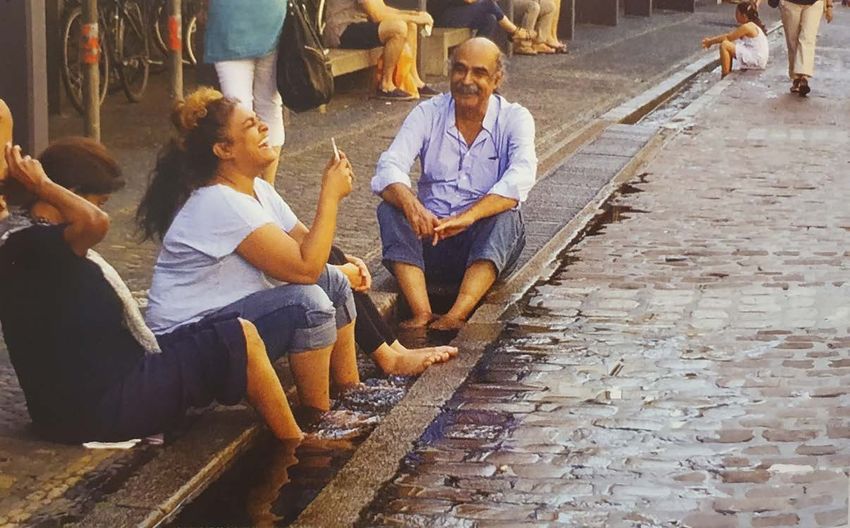
Four people chat and laugh along the edge of a water
channel in Freiburg, Germany (figure 0.1). Walking through
the city on a warm summer afternoon, they have found an
opportunity to rest and refresh in this urban feature. Far
back, in the same channel, a little girl has discovered space
for reflection, or perhaps a space to wait for her friends to
come and play. On each side of the channel, other people
continue walking, uninterrupted through their daily paths.
While others sit at the edge of the street gazing at those
passing by.
Pedestrians can find a special joy in the gaps of time and
Figure 0.1 - Life along the
street, Bächle in Freiburg,
Germany © David Sims.4 Filling the Gaps Introduction 5
space along the street—a possibility to dream, wonder, or
suddenly encounter the unexpected. In the city, streets
behave like the backdrop for urban life. As people move
along the day, those at the edges watch the play of life
unfold. Some actors walk on the sidewalk, while others exit
the stage through thresholds. However, a few dare to partake
in activities not originally prescribed to the grid. In the book
Loose Space, architecture professor and environmental
psychologist Karen Frank and urbanism professor Quentin
Stevens observe the various ways people appropriate public
space in the city for “leisure, entertainment, self-expression
or political expression, reflection and social interaction -all
outside the daily routine and the world of fixed functions
and fixed schedules.”1
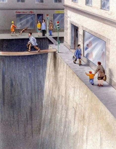
Unfortunately, in North American cities, these unprescribed
activities are rapidly disappearing from the urban fabric,
as many streets undergo a process of erosion. Since the
automobile’s invention, urbanists and architects have been
planning the city to accommodate vehicles leaving little public
Figure 0.2 - Artist Karl
space for people to inhabit. Artist Karl Jilg’s satirical depiction Jilg’s satirical depiction
of the street as a deep
of the street as a deep ravine illustrates narrow sidewalks ravine. © Illustration
by Karl Jilg comissioned
and wavering planks restricting pedestrian movement (figure by the Swedish Road
Aministration.6 Filling the Gaps Introduction 7
0.2). Streets are valued for their circulation capabilities, Filling the Gaps looks at the street’s spatial linearity, physical
serving only to link segregated functions. However, as a proximity and accessibility to all as an opportunity for a
public network, streets have the potential to do more than public life continuum to emerge within the urban fabric.
connect people with a destination; they can also provide The project develops along Bank Street in Ottawa, which is
opportunities to connect people with themselves, with each chosen as a case study; however, to achieve the public realm’s
other, and the city. continuity, the whole city’s network must be considered.
The design approach developed on this particular artery
As any Western modernist-planned municipality, Ottawa could unfold throughout any city street resulting in unique
suffers from segregated zones and functions. The physical interventions for every street corner and gap —or enough
spread of amenities has promoted vehicular congestion street corners and gaps to create a significant change—,
on the streets. Moreover, by prioritizing cars, public spaces fostering a continuum in the urban fabric.
for people to occupy have been reduced to a minimum.
Nevertheless, a projected population growth of 40% from Bank Street crosses Ottawa from North to South. The artery
2018 to 2046 has compelled the municipality to redraft the stands as a major socioeconomic backbone in the city, along
city’s New Official Plan.2 The population jump makes an the three neighbourhoods closest to the downtown core:
increase in vehicular congestion unfeasible, so the time has Centertown, The Glebe, and Old Ottawa South. The conditions
come to give streets back to the people. The New Official of Bank Street in these three neighbourhoods are ideal for
Plan addresses the need for a more engaging and livable public life to emerge. There is a high-density population
urban fabric that fosters sustainable forms of transportation, without the overpowering high-rise built forms, which allows
healthy and inclusive communities, and culture propagation.3 for a sense of human scale, and a diversity of uses – office
But how can this be achieved when through the years, as buildings, grocery stores, clothing shops, schools, houses–
public space was flaked away, city-users were deterred from within walking distance from each other. Therefore, this
using streets? thesis identifies the potential to ‘fill in the gaps’ to revitalize8 Filling the Gaps
streets and foster social interaction. As a way to exemplify
the typologies of gaps and potential of interventions along
the downtown streets, this thesis provides design insight on
four gaps along Bank Street located within the limits of one
of these neighbourhoods. Each space characterizes different
socioeconomic and spatial conditions. Such gaps classify as
dismissed and unseen spaces of unexplored potential as the
current uses do not fulfill their role within the urban fabric.
The project develops a different urban narrative for each
site to construct a new spatial identity through tactical
interventions. The goal is to attract the community to these
spaces with flexible and playful interventions that users can
change or adapt depending on their needs. By engaging
people with the urban fabric, a new city-user can emerge—
the urban dweller. One that takes ownership, adds value
and protects the interests of the public realm. As the new
city-user inhabits and interacts with the gaps, unprescribed
activities will again occupy the city’s network, making it more
likely for public spaces to spread and foster the potential for
social interaction. By filling every gap along the street with
spaces that encourage publicness, a continuous public realm
is re-conceived out of the existing network of downtown
streets.Part One DISMISSED SPACES THEMES & RESEARCH
12   Filling the Gaps                                                                                Dismissed Spaces   13

                         1.1 PUBLIC LIFE ALONG THE STREET

                         A girl holding hands with her father points at the blueberry danishes
                         that two young women enjoy sitting along the bakery shop’s edge. The
                         baker is outside, handing a closed package to a tall man standing next
                         to the shop’s door. The baker removes her mask, and the two discuss
                         the challenges their children have experienced with online learning. Both
                         hoping schools open-up once fall comes—an older woman passes-by
                         walking a chocolate Goldendoodle, slightly smiling at the pair. A young
                         man on the sidewalk across holds a camera up to take a picture of the
                         dog. The older woman waves at him and shouts: “looking to buy a
                         puppy?” Behind him, two boys, with a look of mischief, burst out of the
                         candy shop. Laughing, they run to pet the Goldendoodle. After some
                         play, the two boys walk back home side-by-side, guarding a candy bag
                         in-between.

Figure 1.1 - Two boys
walking home after
running errands along
Bank Street, Ottawa,
2020.© Photographed by
the author.
14 Filling the Gaps Dismissed Spaces 15
The story above is fictional, written while observing life on
Bank Street one summer day of 2020 during one of the The lack of interactions and public life observed in North
author’s site visits. Although all these characters were present American urban centers has been a topic of study among
in the same space simultaneously, these interactions did not scholars, urbanists and city councillors for decades. In the
occur. After buying the blueberry danishes, the two young 1960s, a critical voice emerged —urban writer Jane Jacobs
women walked away from the bakery as there was no space (1916-2006)— with her book Death and Life of Great
to sit and chat. The little girl passed-by a few minutes later, American Cities. She presented a vision of a city made for
but there were no danishes to see. The baker gave a package people that contrasted with the principles and ideals of
to the man standing outside the shop; the man asked the the most influential urban planners, architects and city
baker about her child but quickly left the scene as he saw councillors at the time.4 Jacobs’ observations opened the
the women with the Goldendoodle coming along. There was door to the study of public life, influencing many scholars’
not enough space on the sidewalk for all these characters work, including professors Karen Frank and Quentin Stevens.
to maintain a 6-feet separation, which was a COVID-19 However, even though academics have broadly discussed
restriction imposed by the municipality to prevent the spread the importance of public life, North American cities have
of the pandemic that broke worldwide in 2020. The woman failed to implement adequate solutions to develop urban
with the dog was wearing a mask that covered her mouth, public spaces.
so even though she glanced at the baker, it is hard to tell if
behind the mask hid a saluting smile. The young man on the While North American urban planners and city councillors
sidewalk across tried to take a picture of the Goldendoodle, dismissed Jane Jacobs’ principles, in Europe, architect and
but he struggled as the cars passing-by obstructed the view. urbanist Jan Gehl meticulously observed and recorded public
And finally, the two boys walked straight back home after life. In 1971 Gehl presented his findings on Life Between
running their errands, as the street did not seem like a safe Buildings.5 In 2000 Jan Gehl founded the Danish firm Gehl
place to play with the dog (figure 1.1). Architects to spread his early research and ideas of people-16 Filling the Gaps Dismissed Spaces 17
centred urban design. Today, Gehl’s unique understanding of if the space is attractive and available,9 two qualities that
public space’s quality and design conditions is visible in many ordinary North American urban streetscapes often lack.
contemporary European urban models like the Barcelona These activities include taking a walk at lunchtime, standing
Superblock in Spain, which will be further discussed in part outside under the sun, or sitting down while eating a danish.
three of this thesis. Social activities are those that have not been prescribed
by the grid but rather emerge as associated activities of
Let us go back to the description of life on Bank Street the other two categories.10 In the description above, social
presented at the beginning of this section and revisit it activities were interrupted by a lack of infrastructure, space
together with Gehl’s design theories and principles to uncover and security along the street. The two young women did not
the missing elements in this urban space. According to find a sitting area to eat and chat. There was no space on the
Gehl, for streets to host public life, they must accommodate sidewalk for the baker and the man to start a conversation.
infrastructure for three main activities to unfold: necessary, And the cars on the street discourage both the photographer
optional, and social activities.6 Necessary activities are those and the kids from pursuing new ventures. Many streets
imperative to the space in which all participants engage.7 today lack social connections. A lack of interactions at the
Moving from one place to another represents a necessary street level means a reduction of social cohesion among the
activity within the street. This action was performed by all of neighbourhood. Besides the economic stagnation empty
the characters in the story above. Other necessary activities streets generate, the absence of social connections can also
can be commercial, especially along main streets, which lead to fracture communities.
often form a neighbourhood’s economic backbone.8
Although all streets allow for some form of circulation,
most lack the infrastructure to support optional and social
activities. Optional activities are pursued voluntarily. Only18 Filling the Gaps Dismissed Spaces 19
1.2 THE STREET AS THE FOUNDATION
In Death and Life of Great American Cities, Jane Jacobs
compares cities to a living organisms. In this metaphor,
streets form the circulation network through which the city’s
life flows. Therefore, streets are a fundamental unit of public
space making-up the city; they weave into neighbourhoods,
which then agglomerate together to shape a broader
ecosystem.12 Within the city, streets determine “the security,
the social cohesion and economic development” of the
“Streets and their sidewalks, the main public spaces of a city, are its most whole.13 As with anything in nature, events at the micro-
vital organs. Think of a city and what comes to mind? Its streets. If a city’s scale produce effects on the macro scale. In North American
streets look interesting, the city looks interesting; if they look dull, the city
cities, vehicular circulation has become the primary focus
looks dull.”11
-Jane Jacobs for street design. By diminishing streets to transit networks,
cities have been impaired with congestion and segregation,20 Filling the Gaps Dismissed Spaces 21
reducing spaces for public life.14 passage and transit. In this city, inhabitants must travel to
specific destinations to find space for public life. In contrast,
As a result, the street image is distorted as a two-dimensional in this thesis, it is argued that the urban fabric should be the
surface only to be used by vehicles to move, forgetting one providing a continuum space for publicness to emerge
about the other multiple layers of spaces that compose it. at every street corner and along their paths.
Perpendicular to the ground plane, the building’s edge rises.
The threshold accommodates the various activities that The etymology of the word street derives from the Latin
attract people to the street. Parallel to the roadbed, there root stere- which translates to “spread, extend, stretch
is the sidewalk where people move and interact with one out.”15 Throughout history, streets have played the role of
another. Through this layer, pedestrians can experience the connectors, stretching and extending city life from indoors to
city and identify themselves in it by feeling the textures outdoors, and private to public. The Carlo Felice Theater in
defining the edge, perceiving the mixing scents, and listening Genoa, Italy, stands as an example of this urban pattern. This
to the melody of the everyday. The sky and foliage make up theatre was designed in 1827 by Carlo Barabino (1768-1835)
the top plane, connecting people with nature, the passage and rebuilt by Aldo Rossi (1931-1997) after the Second World
of time and the changing seasons. War destroyed its interiors. Within the theatre’s footprint,
an indoor public plaza connects to the street, granting the
Observing Ottawa’s morphology, it is possible to notice public realm permeability to the building’s inside (figure
specific destinations where people can connect with the 1.2). Before the automobile’s rise, North American city’s
city and outdoor communal activities can occur. The Byward images also show streets as spaces for private life extension.
Market, Major’s Hill Park and the Lansdowne complex, for Back in 1914, streets were occupied by people, and everyday
example, are destinations where different groups of people activities unfolded along these spaces. Streets represented a
can gather around. While these spaces allow for lingering, place for children to play, small merchants to sell goods and
they are considered arrival points rather than places of dwellers to gather around (figure 1.3). 1622 Filling the Gaps Dismissed Spaces 23
As a series of spaces weaved together, streets should be able
to provide a continuous public space for people. With the
New Official Plan, the City of Ottawa recognizes the need
to invest in streets and sidewalks to reshape and reform
the cityscape through urban design. To accomplish this, the
city proposes two policies. Policy 2.2.4.1 encourages the
Street development of 15-minute neighbourhoods, which act as
Public Plaza
“complete communities that support active transportation
and transit, reduce car dependency and enable people
to live car-light or car-free.”17 Policy 4.6.3 promotes the
Figure 1.2 - Model of Carlo development of living streets, which refer to the “temporary
Felice Theater in Genoa,
Italy. Designed by Aldo reallocation of street space from primarily serving vehicles
Rossi in 1991.
to serving people.”18 These two policies can ensure a future
for public space to emerge in city streets. However, the
New Official Plan does not outline implementation steps or
an updated city budget to allow for these changes. In the
Ottawa Citizen’s article, “Dresden: Ottawa’s official plan is
bold. Will city council be bold too?”, architect Toon Dresden
points out that “creating the built environment is a political
act.”19 As a city that often struggles with slow bureaucratic
Figure 1.3 - The street
as a place for children to processes, the changes this city needs cannot be left to be
play, small merchants to
sell goods and dwellers undertaken by the government alone.
to gather around. Hester
Street, New York, 1914. ©
Maurice Branger.24 Filling the Gaps Dismissed Spaces 25
1.3 THE STREET IN THE TIME OF COVID
Throughout the Covid-19 pandemic, the importance of public
health and personal distancing in our everyday lives became
the priority. Provincial authorities asked people to transfer
their work and leisure lives inside.20 As private businesses
and vehicles withdrew from the streets, a once buried public
space emerged. Many cities across Canada opted to open-up
portions of their streets and allowed people to access public
space while complying with social distancing restrictions.21
Ottawa was a little late in the game, as the municipality
feared that opening-up streets to pedestrians would lead
to overcrowding.22 Eventually, other public entities worked
Figure 1.4 - A summer day
in Byward Market Square, towards granting more space for people in the city: the NCC
during the COVID-19
pandemic, Ottawa, 2020. closed the Queen Elizabeth Driveway to vehicular traffic,
© Photographed by the
author.26 Filling the Gaps Dismissed Spaces 27
and Westboro’s councillor Jeff Leiper blocked off a stretch
of Byron Avenue.23 After being confined to their homes for As businesses move onto the street, they tend to set physical
weeks, these tactical transformations encouraged people barriers and behavioural regulations that restrict city-users’
to walk around the block, enjoy the sun and safely talk to freedom of movement and diversity of use. In this particular
neighbours six feet away. example, the street’s section intended for pedestrian
movement is too narrow for activities other than circulation
For a while, opening-up streets to the public while closing to occur (figure 1.5); to stop for a moment or gather with
them to traffic allowed people to reappropriate the public friends, a person along this path must pay to the businesses
sphere. However, the second phase of the lockdown revealed lined-up along the sidewalk for the experience. In the future,
structures of power and invisible boundaries that encompass city leaders must think of a more balanced and inclusive
the public realm. The partial reopening of cities allowed approach for private entities and the public to share the
private enterprises like restaurants to expand their dining sidewalk. For example, an option can be for municipalities
rooms onto the street. Although it is crucial to recognize that to set-up areas for open tables that are accessible to all,
the economic crisis would have put restaurants and other including the surrounding restaurants’ customers.
shops out of business, the total occupation of the public
realm by the private sector has unfortunate consequences
for city-users. For instance, in Ottawa, patios taking over
the ByWard Market Square’s sidewalk created a barrier of
disconnection between public and the buildings of the urban
fabric (figure 1.4). The sidewalk is part of the public realm;
Figure 1.5 - A fall day
nevertheless, private entities enclosed the area and built in Clarence Street and
Byward Market Square,
fortified enclaves to open-up space for paying customers during the COVID-19
pandemic, Ottawa, 2020.
only. The same policies that previously helped people re- © Photographed by the
author.
inhabit the public realm suddenly restricted the same space
for private consumption.Part Two
A WALK ALONG THE STREET
SITE ANALYSIS30 Filling the Gaps A Walk Along the Street 31
2.1 THE STREET
PUBLIC LIFE ON BANK STREET
In this quote, Gehl Architects’ creative director and author of
the book Soft City, David Sim, briefly describes the evolution
of the street into city life. As connectors of activities, streets
can bring people together and enable them to share
portions of their private life in the public realm. However, in
Ottawa, there is often not enough space available for people
to extend life onto the street, as most spaces are privately
owned and commercial in nature. The following chapter
“The most ancient traces of human life on Earth are paths. Networks of looks at this urban pattern and its consequences on Bank
paths came long before buildings and urban blocks, marking the patterns
Street.
of mobility and reflecting economy of human energy: walking. The street
as a space resulted from connecting these patterns of human mobility to
the human activities in buildings.”24 Bank Street emerges at the northernmost part of Ottawa, a
- David Sim
few steps west of the Parliament, perpendicular to Wellington32 Filling the Gaps A Walk Along the Street 33
Street, within the Centertown neighbourhood. Life on the Ottawa could be an ideal location for a public life continuum
street unfolds among a white masonry backdrop on one side to emerge. In Death and Life of Great American Cities, Jacobs
and a dark steel facade with an open plaza at ground level on lists four indispensable conditions to generate diversity:
the other. The long artery represents a significant thread in concentration, small blocks, aged buildings, and mix-uses
the city’s network, crossing vital streets and neighbourhoods and services.26 From the Centertown neighbourhood to Old
along its path. From Centertown to Old Ottawa South, Bank Ottawa South, Bank Street meets three out of four of these
Street condenses multiple connecting points attracting conditions. Superficially, it might seem that Bank Street hosts
diverse groups of people (ethnic, socioeconomic, age) to mix-uses and services like schools, residential spaces, office
travel along the street. While walking down Bank Street, buildings, etc. However, Bank Street hosts mainly commercial
a dweller will find a pedestrian promenade that bridges services at ground level, and these spaces are not publicly
walkers to various downtown office buildings, Sparks Street. accessible. As mentioned in section 1.1 Public Life Along the
Travelling down south, there is Somerset Street; along this Street, commercial services are categorized as prescribed
path lives Ottawa’s Chinatown and a section of Little Italy. activities. In Bank Street, 84% of the space at ground level
Further down, Bank Street morphs into two sets of bridges. is bounded to prescribed activities: 47% retail storefronts,
One crosses over the Rideau Canal and the other over the 9% miscellaneous spaces (such as institutions and religious
Rideau River. From here, the street connects to bike and buildings) and 29% vehicular transit. That leaves only 16% of
pedestrian pathways for people to contemplate and enjoy a the street for public use, including pedestrian circulation and
landscape of greenery and water over the changing seasons. the emergence of unprescribed social activities.
This long artery can connect city-users with many places in the
city, attracting a diverse population to the street. In Soft City,
Sim states that diversity and concentration are two necessary
conditions for livable urban spaces.25 Hence Bank Street inA Walk Along the Street 35
2.2 THE NEIGHBOURHOODS
CENTERTOWN, THE GLEBE AND OLD OTTAWA SOUTH
The great length of Bank street allows over its 70km
development –making it the longest street in Ottawa– for
a street life’s study conducted through the lenses of three
different neighbourhoods closest to downtown: Centertown,
The Glebe and Old Ottawa South. Along these three
neighbourhoods, Bank Street acts as a connecting artery to
other areas of the city (figure 2.1).
Figure 2.1 - Map of Bank
Street’s neighbourhoods.A Walk Along the Street 37
Empty lot
CENTERTOWN
Centertown is the heart of Ottawa’s downtown (figure 2.2).
Over the years, the area has experienced residential growth
tied to work proximity and walkability advantages.27 Making
adults (25-64 years old) represent 68.8% of the area’s
population.28 Compared to the other neighbourhoods in
this study, Centertown has the highest percentage of people
living alone, 39.5%.29 However, along Bank Street, space for
social activities is minimal. The streetscape comprises of
some office and apartment towers, two storey-buildings and
a few religious entities.
Most buildings use the ground floor for commercial
Figure 2.2 - Map of
Bank Street along purposes, marking the edge between private and public.
Old Ottawa South38 Filling the Gaps A Walk Along the Street 39
Along the twenty blocks that comprise this section of Bank Street,
there are only two areas designed for public gatherings: the Bank
of Canada Museum’s plaza and a community street garden outside
the Centertown United Church (figure 2.3). Other open spaces are
dormant gaps between structures or empty street corners like the
empty lot enclosed by a metal fence between 136 and 152 Bank
Figure 2.3 - Community Street and L’Esplanade building’s empty corner (figure 2.4). Aside
street garden outside
the Centertown United from the Bank of Canada and the Centertown United Church’s
Church, Ottawa, 2020.
© Photographed by the garden, public infrastructure mainly consists of about ten benches
author.
along the sidewalk over the 20 block span.
Figure 2.4 - Empty lot
enclosed by a metal fence
between 136 and 152
Bank Street, Ottawa, 2020.
© Photographed by the
author.A Walk Along the Street 41
Patterson
Creek Park
THE GLEBE
Once considered a rural, suburban area at the city’s
limits,30 the Glebe flourished to be one of Ottawa’s vibrant
neighbourhoods (figure 2.5). Today, families with children
and youth make up most of the area’s population; 55.5%
adults (25-64 years old) and 28.2% of children and youth (0-24
years old). However, the eclectic coffee houses, office spaces
and unique local shops attract many young professionals to
the street. While in Centertown, Bank Street is one of many
commercial spaces. In the Glebe, Bank Street functions as
the main commercial strip. Buildings are primarily low-rise
with commercial ground floors, except for some mid-rise
and high-rise apartment buildings around Lansdown.
Figure 2.5 - Map of
Bank Street along
The Glebe42 Filling the Gaps A Walk Along the Street 43
The blocks’ edges are sometimes more spread apart than
Centertown, which sometimes allows for open spaces that
people can inhabit. For instance, The Patterson’s Creek Park
intersection opens-up views of the park, which provides a
visual break from the storefront (figure 2.6). However, other
smaller gaps like alleyways are not as engaging as they are
Figure 2.6 - The often used as parking spaces (figure 2.7). Since this section of
Patterson’s Creek Park
intersection opens-up Bank Street counts with sixteen other parking lots and street
views of the park, Ottawa,
2020. © Photographed by parking space, some gaps could be used for public purposes.
the author.
Figure 2.7 - Alley besides
745 Bank Street, Ottawa,
2020. © Photographed by
the author.A Walk Along the Street 45
OLD OTTAWA SOUTH
Bundled between the Rideau River and Rideau Canal lies Old
Ottawa South (figure 2.8). This area is home to many young
families, with children (0-14 years old) and youth (14-24
years old) making up a large part of the population, 19.1%
and 15.6% respectively.31 This neighbourhood’s morphology
is similar to that of the Glebe, with a traditional main street
occupied by two-storey buildings and residential houses
spread within the surrounding areas.
However, Old Ottawa South differs from the previous two
neighbourhoods, as storefronts do not always define Bank
Street’s edge. Buildings are spread apart from each other,
Figure 2.8 - Map of
Bank Street along leaving large empty gaps along the street (figure 2.9). About
Old Ottawa South46 Filling the Gaps A Walk Along the Street 47
twenty of these gaps are used as parking lots. A characteristic
that makes this path less engaging to walkers. Among the
ten blocks that comprise this section of Bank Street, there
are only two open spaces for public use. One is an open
corner between Belmont and Bank Street, where the Sri
Chinmoy Meditation Centre has placed a cluster of benches
and planters around a small monument (figure 2.10). The
Figure 2.9 - Storefront at other open space is a gathering area in the park at the edge
1063 Bank Street, Ottawa,
2020. © Photographed by of the Rideau River. Besides these two spots, other public
the author.
infrastructure on the street consists of six benches spread
along the sidewalk.
Figure 2.10 - Open corner
between Belmont Street
and Bank, where the
Sri Chinmoy Meditation
Centre has placed a
cluster of benches and
planters around a small
monument, Ottawa, 2020
© Photographed by the
author.48 Filling the Gaps A Walk Along the Street 49
2.3 UNPLEASANT DESIGN
While Bank Street’s functionality invites diversity, it lacks
the infrastructure to host it. For public life to unfold, it is
not enough to enable spaces for movement; favourable
conditions for lingering must also exist for optional
and social activities to evolve.32 In this study, the three
neighbourhoods have high walkability scores: Centertown
at 94.3, the Glebe at 85.8 and Old Ottawa South at 81.3.33
The Ottawa Neighborhood study website describes a walk
score to “measures walkability on a scale from 0 – 100 based
on walking routes to destinations such as grocery stores,
Figure 2.11 - Bench on the
schools, parks, restaurants, and retail.”34 However, the score
intersection Bank Street
and Waverley Street West,
fails to address the quality of the walkable environment. The
Ottawa, 2020.
© Photographed by the
neighbourhoods’ analysis above shows that open spaces in
author.50 Filling the Gaps A Walk Along the Street 51
Bank Street with pleasant conditions for people to stop and needs. However, unpleasant and even hostile designs stand
linger are minimal. on our streets, immutable, untouchable, unchangeable by
most. The scarce design consideration given to environmental
Besides the few gardens outside of religious institutions or qualities along the street has generated an obsolete public
parks intersecting with Bank Street, public infrastructure space pattern in the urban fabric.
consists of randomly set-up benches. Gehl notes in Life
Between Buildings that people tend to seek spaces along
spatial boundaries to stand or sit.35 In Bank Street, sidewalks
are often tight, so benches are mostly found on street corners
with no edge to ground them (figure 2.11). The benches are
bolted to the pavement, so it is impossible to rearrange their
configuration and have a face-to-face conversation with Figure 2.12 - Sarah Ross’
project Archisuits (2005).
another person comfortably. They are also designed with an The project is a critique
against urban spaces and
armrest in the center to prevent a person from lying down. their inhospitality to the
human body, “the suite
The benches’ hostile design contributes to an anti-human includes the structure’s
negative space and allows
narrative in the city. In an interview with radio producer the wearer to fit into the
system designed to deny
Roman Mars, architect and writer Selena Savic defines hostile them.”38 Los Angeles, USA,
2005. © Sarah Ross.
or unpleasant design as a social control technique where an
object’s unique features restrict users’ behaviours.36 Artist
Sarah Ross’ project Archisuits captures this term with a
suit designed to fit a street bench’s structure (figure 2.6).37
The public realm is a shared space that requires constant
negotiations and adaptations to meet city-users’ various52 Filling the Gaps A Walk Along the Street 53
2.4 THE GAP
While Bank St. might lack pleasant conditions for people to
stop and linger, the street comprises a variety of open spaces
with undiscovered potential for publicness. There are voids
between buildings or along facades that go unnoticed on our
daily passing; leftover spaces missing a function or wasting
away as surface parking lots; and oddly shaped pockets
lacking adequate infrastructure for people to inhabit. These
gaps are dormant spaces that break the continuity of the
public realm.
Nevertheless, the lack of defined edges regarding both
Figure 2.13 - Gap along
Bank Street, between functionality and physical barriers welcomes ‘looseness.’
Henry’s and Alterna
Savings, Ottawa, 2020. Franck and Stevens defines ‘loose space’ as a by-product
© Photographed by the
author.54 Filling the Gaps A Walk Along the Street 55
of street life, the different ways city-users discover and
appropriate public space.39 ‘Looseness’ allows for boundaries
to be redrafted and new uses reimagined, providing
opportunities for different forms of interactions with and
within the urban fabric.
Four gap typologies along Bank Street are identified in this
study: the corner, the storefront, the alley and the surface
parking lot. In Part 3, each gap is analyzed and reframed to
explore the possibilities of ‘loose space.’
Figure 2.14 - For this boy
the sidewalk along Bank
Street can suddenly turn
into a bike track, Ottawa,
2020. © Photographed by
the author.56 Filling the Gaps A Walk Along the Street 57
Figure 2.15 - Collection
of corners along Bank
Street, Ottawa, 2020.
© Photographed by the
author.
CORNER
On Bank Street, some corners’ sidewalks extend onto
the roadbed or contain setbacks that provide additional
pedestrian space. But rather than infrastructure for people
to use, this extra space is populated with unpleasant
benches, private patios, or empty parking lots. Within the
block, corners mark the meeting point of two edges. People
walking on the street tend to agglomerate in these areas
as they converge in-between intersections or wait to cross
streets. As suggested by David Sims in Soft Space, these urban
features, are distinct enough to function as an orientation
point or a designated meeting zone.40 These characteristics
make corners ideal locations for community gatherings,
where people congregate, share a meal, or watch a local
performance.58 Filling the Gaps A Walk Along the Street 59
Figure 2.16 - Collection
of storefronts along Bank
Street, Ottawa, 2020.
© Photographed by the
author.
STOREFRONT
Storefronts align along the sidewalk’s edge, functioning as
a two-dimensional barrier dividing the private and public.
However, by occupying a prime piece of real estate for its
accessibility to the public, storefronts could have a more
interactive dialogue with the urbanscape. The façade
design of the ‘Storefront’ for Art and Architecture (1993),
by Steven Holl in New York, can serve as a precedent.41 The
openings and incisions on the façade achieve a degree of
permeability between the commercial and the commons.
Designers and store owners can also rethink the storefront’s
display section. Instead of showcasing inanimate objects,
storefronts can display activities along with the products. For
instance, a furniture store could showcase office furniture
while providing a start-up with a meeting area.60 Filling the Gaps A Walk Along the Street 61
Figure 2.17 - Collection
of alleys along Bank
Street, Ottawa, 2020.
© Photographed by the
author.
ALLEY
A narrow passage carved within the block, the alley is often
misused as a parking spot or a dumpster’s keeper. Two
parallel walls often shape this gap, enhancing the spatial
linearity while limiting side-to-side movement. Alleys behave
as secret passageways people travel through to reach other
streets and invisible neighbourhoods that hide behind the
main avenue. However, more peculiar passageways allow for
upward movement, as they accommodate the emergency
stairways for side buildings. Along alleys, forward movement
is often public, but upward movement is reserved only for
the building’s residents. Nevertheless, as passageways,
alleys can be reimagined for all dwellers to move between
levels, creating a new dimension for the public realm.62 Filling the Gaps A Walk Along the Street 63
Figure 2.18 - Collection of
surface parking lots along
Bank Street, Ottawa, 2020.
© Photographed by the
author.
PARKING LOT
In both the Glebe and Old Ottawa South, surface parking lots
are overpowering the urban fabric. In the Glebe, there are
sixteen parking lots within fifteen blocks; and in Old Ottawa
South, there are twenty parking lots within ten blocks. As
proposed by professor, city planner and urban designer Eran
Ben-Joseph in the book Rethinking a Lot, surface parking
lots in cities could transform into spaces that promote
community activity and play.42 This thesis discusses how
the parking lot can be reoccupied with a variety of parks
that cater to Bank Street’s diverse public needs. A surface
parking lot can turn into a playground for kids, while another
can become a seniors’ gym.Part Three
STREETS OF TOMORROW
METHODOLOGY66 Filling the Gaps Streets of Tomorrow 67
3.1 EMERGENCE
A NEW CITY-USER
This thesis argues for filling the gaps with infrastructure
or temporary activities that boost street life in order to
reimagine a public space continuum. Nevertheless, as the
capital city, Ottawa is constantly struggling between providing
its people what they need or maintaining the image of status
that belongs to a capital city. So far, the municipality has
chosen to portray a prescribed environment of order and
control, where urban space is tied to designated functions
and official uses. As a result, Ottawa’s pristine appearance
and homogenous urban fabric pleases city officials and real
estate investors but fails to reveal the diverse identity of the
Figure 3.1 - Eliza and
Adela Andrew’s Lemonade populations living within it.
stand, photograph by
Kurtis Andrews, Ottawa,
2016. © Photographed by
Kurtis Andrews.68 Filling the Gaps Streets of Tomorrow 69
In 2016 two sisters –five and a seven-year-old Eliza and Adela backlash at the NCC’s decision through social media. A day
Andrews– set up a lemonade stand along Colonel by Drive. after, the NCC granted the two girls a selling permit; and,
For decades, lemonade stands have been a rite of passage a year later, offered more special permits to other young
for kids to learn entrepreneurial skills. Most of the time, this entrepreneurs.47 Frank and Stevens argue that although
also represents a kid’s introduction to street life and other many spaces possess qualities that allow for ‘looseness’, it is
urban activities. However, on this summer day, as the girls up to the public to discover the pwzossibilities of interaction
provided a service to tired bikers passing-by the canal, the within the urban fabric:
NCC showed up to shut down the business, as the girls had no
“The emergence of loose space depends upon: first, people’s recognition
permit to sell on NCC’s land (figure 3.1).43 These regulations of the potential within the space and second, varying degrees of creativity
tend to tighten the usage of urban spaces. According to Frank and determination to make use of what is present, possibly modifying
existing elements or bringing in additional ones.”48
and Stevens, tight space’s qualities opposed those of the
‘loose space.’44 They prevent unpredictable performances in
Through decades, restrictions in Ottawa have inhibited
the public realm, instead building a dull environment where
people’s behaviour within the urban fabric. In 2014, filmmakers
scenes along the street cast the same monotonous actions
Nathan Hauch and Amen Jafri produced a documentary —
over and over again.
The City that Fun Forgot?— exploring Ottawa’s reputation
as a government town. In the film, politicians, journalists
Ottawa’s governing body has realized the impact some
and artists discuss how, through the years, Ottawa has been
restrictions have had on the public realm’s detriment. With
trapped within a culture of conformity; they criticize the
the new policies outlined in the New Official Plan, Ottawa
youth as either seeking complacency in a government job or
hopes to repeal its denomination as “the city that fun
escaping the city searching for creative outlets.49 Although
forgot,”45 to become “the most liveable mid-sized city in
the tech industry seems to have disrupted this way of
North America.”46 However, change cannot come from policy
thinking among the youth, encrypted behaviours like those
alone. After the lemonade stand was shut-down, citizens70 Filling the Gaps
highlighted above still remain coded in the urban fabric. For
a shift in behaviour to occur, a series of tactical interventions
are designed within the gaps for people to interact with the
city and rediscover the public realm’s possibilities.72 Filling the Gaps Streets of Tomorrow 73
3.2 TACTICAL URBANISM
THE POBLENAU SUPERBLOCK
Tactical Urbanism is an approach to city building where
“fast, low-cost and high-impact”50 changes are introduced to
underused urban areas. Urban dwellers and larger entities
alike can initiate these projects, but they always require
individuals’ participation to test and experiment with the
spaces.51 The municipality, developer and designer can later
receive users’ feedback and implement more structural
modifications. Over time tactical changes can define spaces
and transform the way people relate to the urban fabric.
The Poblenou Superblock in Barcelona used tactical changes
Figure 3.2 - The tactical
to help inhabitants reimagine a human-centric narrative
intervention to the
Poblenau Superblock,
within the street. For more than thirty years, urban ecologist
Barcelona, 2016. ©
Photographed by BCNUEJ.74 Filling the Gaps Streets of Tomorrow 75
Salvador Rueda has been pushing the city to redraft its grid citizens found the interventions disruptive, others used the
and grant priority to pedestrians. Rueda redesigned a new space to meet and talk with neighbours. They discussed how
grid, defined by groups of nine-city-blocks, which delineate the tactical interventions could feel more permanent and
pedestrian-only-zones.52 In 2016, schools of architecture eventually requested the city to replace the tires and wood
in Barcelona and Rueda submitted a proposal to the crates with more temporary urban furniture (Figure 3.3).54
municipality to create a superblock in the Poblenou district. Rueda explains that participatory urbanism is essential, as
The municipality granted the permit to close one of the once pedestrian spaces are carved in the city, inhabitants
streets to traffic in order to test things out.53 Using paint, should decide what uses are needed.55
tires, potted plants and wood crates, the students created a
series of play spaces along the street (Figure 3.2). While some Tactical Urbanism stands as a response to the slow and
bureaucratic urban planning processes. It requires citizens’
action to curate the urban fabric gaps like unused alleys,
empty parking lots, dismissed corners, and narrow sidewalks.
Now that the City of Ottawa is drafting the New Official Plan,
the municipality should consider this inclusive approach
to building the city. The outlined policies currently address
the need to transform the city’s urbanscape; and allow for
walkability, culture, and innovation to flourish. However, the
document does not address how to involve the public in
the physical redesign process, perpetuating citizens’ role as
passive consumers.
Figure 3.3 - The Poblenau
Superblock, Barcelona,
2016. © Photographed by In Ottawa, as in many North American cities, restrictions
Maysun.76 Filling the Gaps
and controls within the urban fabric have forged a culture of
citizens that must conform with the activities and experiences
available or provided to them, rather than creating spaces
that satisfy their own cravings. People need to rediscover
the many capabilities public space has to offer. For this, a new
street user must emerge one that, as described by Frank and
Stevens, appropriates public space “to pursue activities not
set by a predetermined program.”56 In this thesis, this new
city-user is referred to as an urban dweller. Tactical urbanism
is a practice that involves the appropriation or occupation
of the urban fabric. Sociologist Saskia Sassen states that “to
occupy is to remake, even if temporarily, a bit of territory,
and therewith to remake its embedded and often deeply
undemocratic logistics of power.”57 Tactical interventions
can promote people first to interact with urban spaces,
eventually change spaces to suit their needs, and finally
produce the public realm continuum. This process, in the
end, can redefine the role of the citizen within the urban
fabric.You can also read