Geospatial Portal 2022 - Product Description
←
→
Page content transcription
If your browser does not render page correctly, please read the page content below
Product Description

Geospatial Portal 2022
Product Description

21 October 2021
Contents
Product Summary ...................................................................................................................... 4

Geospatial Portal Classic Layout.............................................................................................. 4
   Main Functions ......................................................................................................................... 4
   Map Tools and Navigation ........................................................................................................ 9
   Map Layers and Content ........................................................................................................ 10
   Connecting to and Managing Data Sources ........................................................................... 13
   Search for Dataset or Service Metadata ................................................................................. 15
   Search for Geographic Names ............................................................................................... 16
   Edit Underlying WFS-T or PSS Service Resource .................................................................. 17
   Attribute Data .......................................................................................................................... 17
   Mobile Devices ....................................................................................................................... 18
   Support for Business Workflows ............................................................................................. 19
   Create a Personal Storage Service (PSS) .............................................................................. 21
   Administer Instances with the Administration Console ............................................................ 21
   Support User Registration and Login ...................................................................................... 21
   User-Defined Settings ............................................................................................................. 21
   Easily Accessible Multilingual Layouts .................................................................................... 22
   Follow OGC Specifications ..................................................................................................... 23
   Cloud Deployment .................................................................................................................. 24

Geospatial Portal Consumer Layout ...................................................................................... 24
   Key Features .......................................................................................................................... 25
      Display and Navigate Map Compositions ............................................................................ 25
      Feature Information ............................................................................................................. 26
      Measurements in Geospatial Portal – Consumer ................................................................ 27
      Information Bar in Geospatial Portal – Consumer ............................................................... 28
      Easy Printing ....................................................................................................................... 28
      Integration with Google Map Services ................................................................................. 29
      Two Consumer Portal Layouts ............................................................................................ 30
      Share Map........................................................................................................................... 30

11 October 2021                                                                                                                              2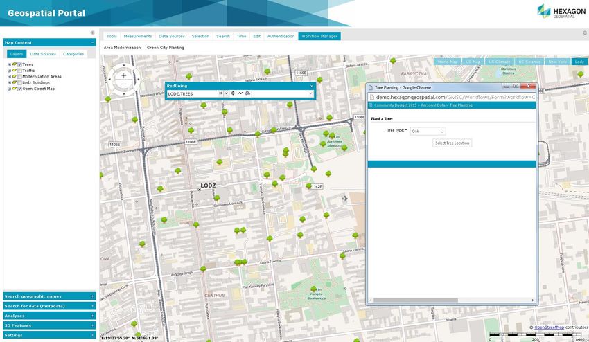
Search ................................................................................................................................. 31
      3D Display ........................................................................................................................... 31
      Display Extruded Data in Geospatial Portal – Consumer .................................................... 32
   Dedicated Mobile App for Geospatial Portal – Consumer ....................................................... 32
      Auto Optimalization of Consumer Portal Layout .................................................................. 33
      WAI Design ......................................................................................................................... 33

Geospatial Portal Features for ERDAS APOLLO ................................................................... 34
   Connect to ERDAS APOLLO .................................................................................................. 34
   Search ERDAS APOLLO Catalog .......................................................................................... 34
   Consume ERDAS APOLLO Data ........................................................................................... 34
   Execute Processes Over the Web .......................................................................................... 35
   Vector Web Service Workflow ................................................................................................ 36

Contact Us ................................................................................................................................ 37

About Hexagon......................................................................................................................... 37

11 October 2021                                                                                                                                3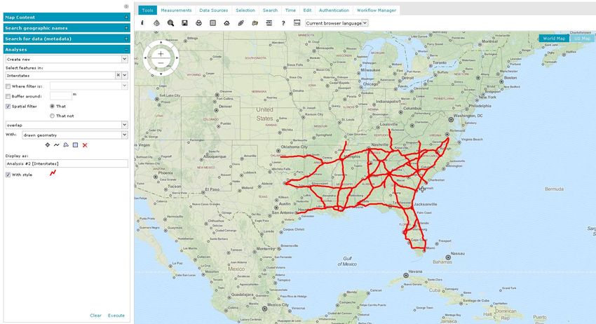
Product Summary
Geospatial Portal – Classic is a full-featured, configurable, and customizable thin-client application that can be
used for finding, viewing, querying, analyzing, and consuming geospatial data published by Hexagon products
or other standards-based web services. Because Geospatial Portal is installed and configured on a web
application server, it can be accessed by multiple users via web browsers.
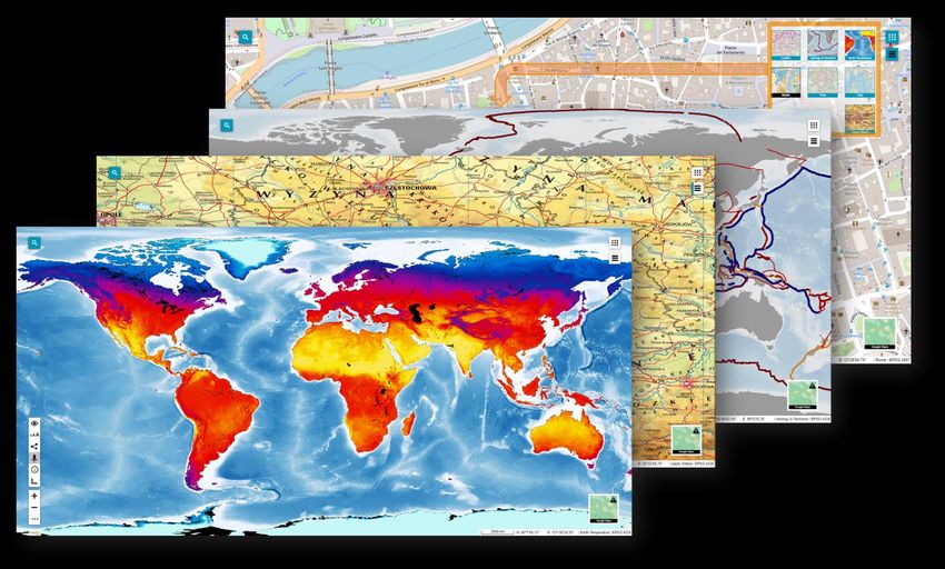
Multiple data sources can be integrated into an easily navigated single map view. The Geospatial Portal
ensures smooth browsing through intuitive navigation controls and technical advances, such as asynchronous
communication, that ensures panning and zooming are not interrupted by having to wait for servers to
respond. The client’s utility is enhanced by additional tools such as measuring area and distance, controlling
the appearance of individual map layers, and saving and recalling the current map context.
Geospatial Portal – Classic supports all the web services and open standards required for modern Spatial Data
Infrastructure (SDI) client applications. This client solution provides International Standards Organization
(ISO)/Open Geospatial Consortium (OGC) standards compliance. Geospatial Portal also offers advanced
functionality, including GeoRSS, coordinate transformation (CT) capability, connection to ERDAS ® APOLLO,
Transactional Web Feature Service (WFS-T) service-based features editing, and ad-hoc dynamic analyses
over Web Feature Service (WFS) or GeoMedia® WebMap Publishing Service (WMPS).
Cutting-edge myVR technology brings rich 3D visualization via WebGL. Geospatial Portal – Classic displays
the world as it is by adapting standard raster services to the elevation model and by handling dedicated 3D
data sources. Moreover, the portal offers extrusion and display of vector data within the 3D world, including
underground features positioned below the globe sphere, and a first-person perspective view.
In addition to the professional-level rich internet application, Geospatial Portal includes a simplified and user-
friendly entry-level layout aimed at non-professional consumers of geospatial data. Optimized for performance
and user experience, Geospatial Portal – Consumer layout takes advantage of the most up-to-date web
technologies and standards.
Geospatial Portal – Consumer layout can be easily accessed on mobile devices using either a web browser or
the GeoMedia WebMap Mobile application. GeoMedia WebMap Mobile runs on Android, iOS, and Windows
mobile platforms and is available for free download from Google Play, the AppStore, and the Microsoft store.
Click on a link below for quick navigation:
Geospatial Portal Classic Layout
Geospatial Portal Consumer Layout
Geospatial Portal Features for ERDAS APOLLO
Geospatial Portal Classic Layout
Main Functions
• Navigate maps easily via intuitive mouse control
• View 2D maps and content from:
• Web Map Service (WMS) 1.1.1 and 1.3.0
• Web Map Tile Service (WMTS) 1.0.0
• GeoMedia WebMap Publisher Service (WMPS)
11 October 2021 4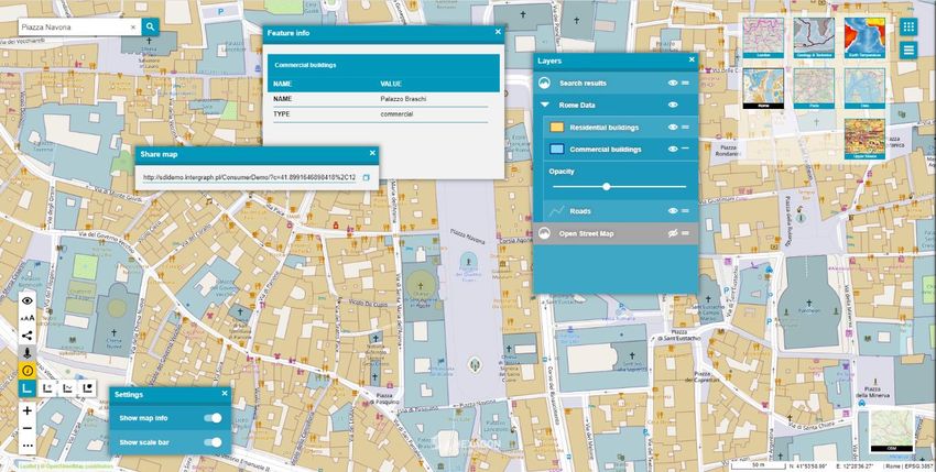
•   Google Maps™ and Bing® Maps
            •   OpenStreetMap
            •   ERDAS APOLLO
            •   GeoRSS feeds

   •   3D display
            •   Take advantage of advanced myVR technology
            •   Display data and services:
                •   Base map display
                •   WMS and WMTS display
                •   ERDAS APOLLO services
                •   GeoMedia WebMap Publisher Service (WMPS), including dynamic analyses over WMPS
                •   3D Tiles (prepared based on GeoTIFF using mTransformer)
                •   3D Objects (prepared based on OBJ, 3DS, KMZ using mTransformer)

11 October 2021                                                                                      5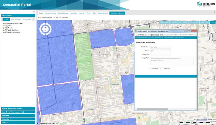
•   Display vector data from GeoMedia WebMap WFS service
          •   Extrude 2-dimensional vector data to rapidly build 3D scenes

11 October 2021                                                              6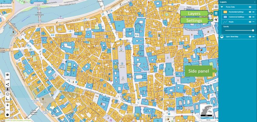
•   Display underground features, both 3D Objects and WFS vector features

11 October 2021                                                                       7
•   Perform sunlight analysis

          •   Display First Person Perspective to explore 3D scenes

11 October 2021                                                       8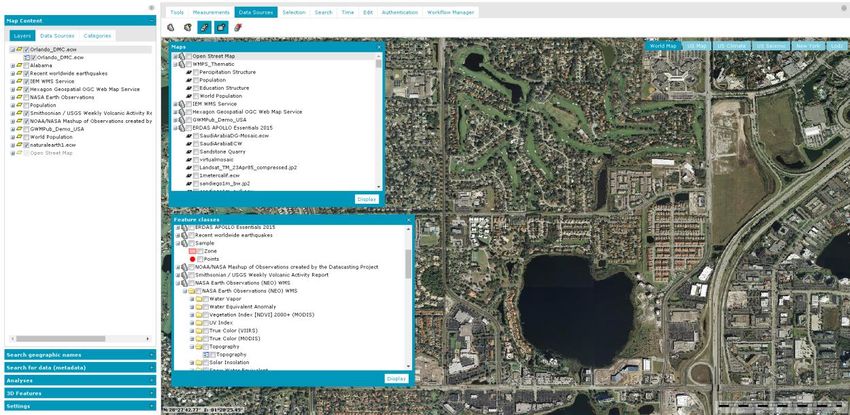
Connect to the web services for discovery, view, download, and coordinate transformation.

    •   Query data sources:
             •   WFS services, both WFS 1.1 and WFS 2.0 (ISO 19142)
                 •   Use Filter encoding (ISO 19143 supported)
             •   GeoMedia WebMap Publisher Service (WMPS)
             •   Catalog Service for the Web (CSW) services for datasets, datasets series, and services metadata
                 •   Retrieve information from catalog services (CSW 2.0.2 ISO AP 1.0)
    •   Create and edit vector data stored in a user-defined service (Personal Storage Service) as well as accessed via
        WFS-T service
    •   Search for information:
             •   Addresses based on OpenLS (Open Location Service) or LUWS (Location Utility Web Service)
             •   Geographic names using the Gazetteer Service (WFSG)
    •   Transform coordinates online using Web Coverage Tiling Service (WCTS) and WPS-CT support
    •   Run Geospatial Portal on mobile devices:
             •   Using mobile web browser (Geospatial Portal will automatically run in a dedicated mobile layout)
             •   Using mobile application for Android, iOS, and Windows OS mobile devices (Consumer layout)
    •   Create and manage user profiles:
             •   Store user maps and workspaces
             •   Manage user maps and workspaces
             •   Save map context according to OGC Web Map Context (WMC) standard

Map Tools and Navigation
    •   Navigate the map using a mouse or the Navigation Control
    •   Read coordinates over mouse position
    •   Change map scale using the Scale Bar
    •   Position map view using the Overview window

11 October 2021                                                                                                           9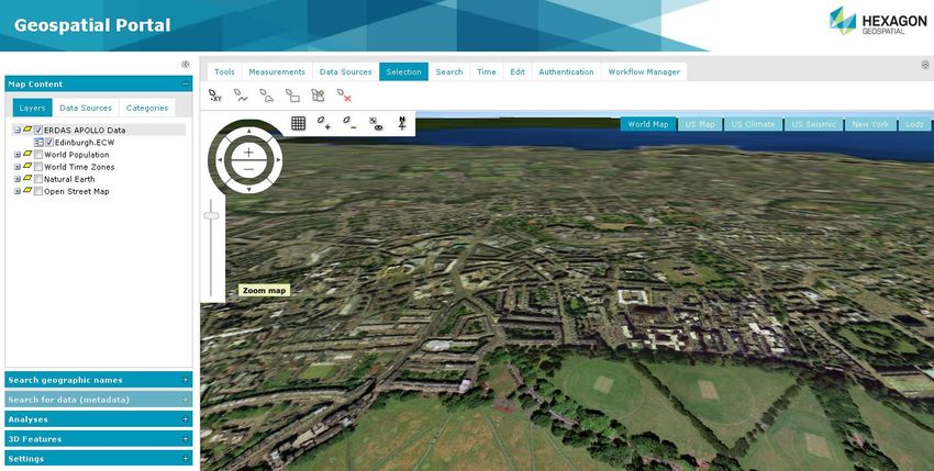
•   Select features on the map by point, line, or area
   •   Get point coordinates
   •   Measure distance and area

   •   Print simple map
            •    Select format, page size, template, scale, DPI, and orientation for print job
                •   Supports portrait and landscape templates
                •   Title and other textual fields on the printout are configurable
                •   Relocate the effective printout area by mouse move
   •   Quick map printing using the standard browser print facilities
   •   Display Feature information at selected point
   •   Share link to a specific map view
   •   Dynamic object view for vector features

Map Layers and Content
   •   Manage layers, components, and content displayed on the map
   •   Map Window displays all the layers that make up the map
   •   Manage Map Content
            •    Group data layers by source/data providers
            •    Arrange available layers into categories
            •    Drag and drop to change the order of layers on the map
            •    Assign custom layer graphics with WMS services
            •    Check box to toggle layer visibility
            •    Click the context menu to access more options available for single layers and/or services

11 October 2021                                                                                              10
• Define layer styles (styling capabilities dependent upon individual third-party services)
• Attribute-based symbology based on:
• Unique value
• Range thematic
• User-defined
• Quick thematic legend creation with automatic classification and color assignment
11 October 2021 11• Define layer properties such as display mode, locatability, translucency, format, etc. • Define a pattern fill for area geometry 11 October 2021 12
•   Set graphic for point geometry type

    •   Display and edit labels, including label rotation, for WFS services
    •   Filter layers:
              •    Filter display of vector data from data sources such as WMPS and WFS
              •    Filter can be set separately for each feature class layer
              •    Objects can be filtered in the map window using available attributes
    •   Set scale bands for each layer in the map
    •   Add predefined scales
    •   Save and reuse user maps and workspaces within a configuration
    •   Manage and configure map contexts (WMC), including export and import

Connecting to and Managing Data Sources
Geospatial Portal – Classic offers numerous service connectors that let you consume data and functionality
delivered by web services.

    •   Use administrator-defined connections to a service, modify them, or add your own
    •   Connect to web services asynchronously
    •   View all services currently connected to and available in the Geospatial Portal

11 October 2021                                                                                              13
Supported services include: • Authenticated web services • WMS Time parameter 11 October 2021 14
The lists of available service types and predefined services can be configured using the Administration
Console.

Search for Dataset or Service Metadata
Geospatial Portal – Classic lets you connect to OGC Catalog Service for the Web (CSW) and search for
metadata available in a catalog or federated catalogs. Icons designate what type of data is displayed, including
for series, service, or dataset.

    •   Add service to map and center map on selected metadata (requires the web service metadata to provide this
        information)
    •   Obtain detailed information about discovered metadata
    •   Search metadata using multiple parameters
    •   Visualize the range for found metadata on the map

11 October 2021                                                                                                     15
Search for Geographic Names Connect to WFS-G (Gazetteer) service or services to search geographic objects such as cities, regions, and points of interest. See information and the location in the map window for each search result. 11 October 2021 16
Edit Underlying WFS-T or PSS Service Resource
    •   Add features to feature classes
    •   Edit, move, continue, and remove geometry
    •   Insert text on the map at any angle
    •   Remove selected features from the database
    •   Snap functionality
    •   Markers and annotation layers, including add, edit, and delete
    •   Work with WFS-T or Personal Storage Service (PSS), depending on the need

Attribute Data
    •   Display feature classes and attribute values for selected data sources (for example, WMPS, WFS, or PSS)

    •   Data is presented in tabular form
             •    Data Window can contain many tabs with displayed data
             •    Data for one feature class is presented on a single tab
             •    Data view allows sorting, hiding columns, changing column size and order
    •   Selecting records in the Data Window automatically highlights the corresponding objects on the map
    •   Export all or selected features to CSV file

Analysis
Perform a series of attribute or spatial queries on data from selected sources. Set spatial filters or create a
buffer. Geospatial Portal uses capabilities of underlying services to enable available query criteria and
operations. Query definitions are saved in the Legend and can be reused or modified at any time. Updates to
queries are instantaneously updated in the map and data windows.

11 October 2021                                                                                                   17
Mobile Devices
Geospatial Portal automatically displays a simplified interface, in either landscape or portrait orientation, when
viewed on a mobile device.
On mobile devices, you can:
• Display, zoom, and switch predefined maps
• Show feature attributes (GetFeatureInfo)
• Maintain a list of pre-defined maps
11 October 2021 18• Access the Scale Bar
• Center the map based on device localization capabilities (GPS, A-GPS)
• Use your finger to scroll the map
• Change map scale with zoom buttons or with device-specific gestures, such as pinching the screen
• Find your location on the map
Support for Business Workflows
When deployed with Hexagon’s Workflow Manager, Geospatial Portal can be used to automate and organize
the typical workflows of government agencies, utilities companies, and enterprise users.
• Run pre-configured workflows with the Workflow Manager
• Combine map-based operations with the steps of business workflows, including map navigation
• Display, edit, and select features and attributes
11 October 2021 1911 October 2021 20
Workflows can be easily configured and launched from the Geospatial Portal interface. Administration Console
lets you add new icons that represent the workflows.

Create a Personal Storage Service (PSS)
Personal Storage Service lets you create a local service in the session into which you collect vector data. You
can create feature classes, define attributes, add features, add and edit attribute values, and display vector
data served by a service in the map and data windows.

Administer Instances with the Administration Console
A web-based Administration Console provides the means for creating and configuring all aspects of server-
side engines, web services, and web applications in a single place. Portal instances (portal applications
available under a given web address) can be created, configured, and removed. For each portal instance, the
following features can be configured:

    •   Banner image
    •   Application title (multilingual)
    •   Existence and order of interface icons available to end users
    •   Service types available to end users
    •   Predefined services
    •   An initial default workspace, including all pre-configured services
    •   Color theme
    •   Appearance and behavior of map variants

Support User Registration and Login
Geospatial Portal provides functionality for user registration and login. Registered users have their own profiles
(folders on the server) that store user maps.

User-Defined Settings
Options in the settings tab let you:

    •   Change the coordinate system
        •   Administrator pre-defines the list of available coordinate systems
        •   Map ranges are recalculated when coordinate system is changed

11 October 2021                                                                                                21
• Change screen size
• Toggle on/off:
• Axes order
• Coordinates visibility
• Scale bar visibility
• Navigator visibility
• Cross-hair indicating map center
• Customize the view in the browser window, such as hiding elements of Geospatial Portal to give you more map
window area
Easily Accessible Multilingual Layouts
• Select language from a dropdown list (if available, Geospatial Portal automatically starts in the default user’s web
browser language).
• LTR (left to right) and RTL (right to left) languages are supported. Geospatial Portal layouts adapts to the
currently chosen language automatically. The display of the controls for the layout is changed, and the text is
aligned to the right or left.
11 October 2021 22• Adjust font size. Three font sizes are available. Adjust the font size by pressing one dedicated button.
• High contrast mode. Designed in accordance with W3C Web Accessibility Initiative (WAI) guidelines and
standards, the high contrast mode is very useful to people with disabilities.
Follow OGC Specifications
Geospatial Portal works in accordance with OGC discovery, view, download, and transformation services. It
supports the following OGC/ISO specifications:
11 October 2021 23• WMS 1.1.1, 1.3.0 [time dimension]
• WMTS 1.0.0
• WFS 1.1.0, 2.0.0
• WFS(T) 1.1.0, 2.0.0
• WFS(G) 1.0
• CSW 2.0.2, ISO AP 1.0
• WCTS 0.3.0
• OpenLS [OLS] 1.1
• WMC 1.1
• GeoRSS
• FE 1.1.0, 2.0.0
• GML 3.2.1
Cloud Deployment
All Geospatial server products can be deployed in the cloud (via Amazon EC2).
Geospatial Portal Consumer Layout
Geospatial Portal – Consumer layout is a simplified, user-friendly, entry-level layout for non-professional
consumers of geospatial data. You can use maps for discovery and visualization with minimal effort. Optimized
for performance and user experience, Geospatial Portal – Consumer takes advantage of the most up-to-date
web technologies and standards.
11 October 2021 24Geospatial Portal – Consumer provides smooth and intuitive navigation on ubiquitous touchscreens. The technology framework behind Geospatial Portal – Consumer, including CSS3 and HTML5, remains consistent across the broader Hexagon mobile story, which is crucial to homogeneity of configuration and deployment. Geospatial Portal – Consumer offers a high level of usability across desktops, laptops, tablets, and mobile phones — anywhere modern web browsers are supported. Configuration of Geospatial Portal – Consumer is done via the web-based Administration Console. Both pre- configured maps and search sources can be easily configured without any need for programming. Direct access to Oracle® and support for GeoMedia data warehouses make the search easy to configure and very powerful. Key Features Display and Navigate Map Compositions Geospatial Portal – Consumer displays both raster datasets published through WMS, WMPS, or WMTS services and vector feature classes published through WFS. WFS service is offered in GeoMedia WebMap. Users can define several map compositions and smoothly switch between a set of pre-configured maps. The active map composition is highlighted in Geospatial Portal – Consumer. In the menu, available layers are listed, grouped under the name of the service the layers come from. Users can change the layer order within the group by dragging and dropping an individual layer, switch a layer on or off, or modify a layer’s opacity for optimal map display. 11 October 2021 25
Feature Information
The Feature Info dialog in Geospatial Portal – Consumer layout displays information about features portrayed
on the map.

When using the Feature Info dialog in Geospatial Portal – Consumer, the tooltip showing available layers for
the feature area appears. After selecting the layer, the Feature Info dialog opens immediately. Because the
Feature Info dialog is floating (not modal), users can keep it open continuously while simultaneously navigating
map layers, performing measurements, and so forth.

11 October 2021                                                                                              26
Measurements in Geospatial Portal – Consumer
Users can perform basic measurements, such as gathering point coordinates or calculating the distance
between two locations. Measurement tools – Measure Point, Measure Line, and Measure Area – are
accessible by clicking the Measurement button in the left toolbox.

The measurement results are displayed the map over the measured feature.

11 October 2021                                                                                         27
Information Bar in Geospatial Portal – Consumer
The Information Bar provides geographic information for the current cursor position in a map window.
Displayed in the bottom right corner in the application, the Information Bar shows:
• Geographic latitude and longitude
• Name of the active Map Composition
• Coordinate system EPSG code of the current map
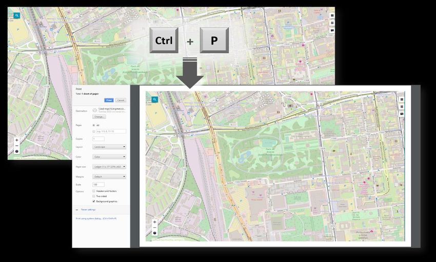
Easy Printing
Maps can be printed using the standard browser print facilities. Use the Ctrl+P keyboard combination to
quickly print the map currently displayed in Geospatial Portal – Consumer layout.
11 October 2021 28Integration with Google Map Services It is possible to view Google Maps and explore Google Street View in Geospatial Portal – Consumer layout. The Google Maps layer configured with Consumer Portal can be used as a base map and/or a standard layer added to the legend. Users (for both base map and standard layer) can choose the map type: roadmap, hybrid, traffic, satellite, or terrain. Exploring the Google Street View in Consumer layout is intuitive and uses well-known Google Street View native functionality. The Google Street View mode is available in a floating and resizable pop-up window. The marker on the map shows your location and view direction and follows the position when you move in the Street View. With integrated Google Search service, Consumer Portal users can search a POI or address by using the standard Consumer Portal search control. Pins with the locations of searched objects appear on the map. 11 October 2021 29
Two Consumer Portal Layouts
    •   Window (default):
        •   All windows are modal and floating
        •   All windows are resizable.
        •   The position of the floating windows is retained
    •   Panel
        •   Settings and Layers dialogs are displayed in the sidebar panel

Share Map
Copy the URL and share the current map composition. A shared map preserves all its properties, including:

11 October 2021                                                                                             30
• Current map composition
• Layer settings
• The selected base map
• The map range and scale
Search
POI and Addresses – search for interesting objects or addresses. The following search engines are supported:
• Google Search (requires registering of Google API Key)
• LUWS (Location Utility Web Service): uses geocoding to determine the position and address of an object (POI).
With LUWS, users can search addresses, points of interest, cadastral data, or any defined geospatial objects.
LUWS service is provided within the GeoMedia WebMap product.
• Oracle and WMPS database: define search in Administration Console by using the Search Configuration wizard.
• Coordinates - The built-in coordinate search allows users to type coordinates in Decimal Degrees format
(DD.ddddd; e.g., 51.23456 21.78654) or Degrees, Minutes, Decimal Seconds (DMS; e.g., 51° 14' 4.42" N 21° 47'
11.54" E). The coordinate separator can be a space or comma. To determine the direction, you can provide
cardinals or type a minus character for West and South (e.g., 34.23456S 61.78654W or -34.23456 -61.78654).
3D Display
In addition to the traditional 2D map display in Geospatial Portal – Consumer, you can also view data in 3D.
Geospatial Portal – Consumer displays a base map on a three-dimensional globe and renders other supported
data sources where appropriate. With 3D objects being displayed in Geospatial Portal – Consumer, you can
see how the shadows cast by objects at a given latitude and longitude are changing during the day and during
the course of seasons throughout the year.
11 October 2021 31Display Extruded Data in Geospatial Portal – Consumer In Geospatial Portal – Classic, users can extrude two-dimensional vector features and view them in 3D scenes. Now users can view 3D scenes with extruded features in Geospatial Portal – Consumer as well. The highlight style for selectable WFS objects is customizable. Dedicated Mobile App for Geospatial Portal – Consumer Based on Hexagon’s Mobile SDK, a touch-friendly GeoMedia WebMap Mobile application is available out of the box. The app displays 2D Consumer layout maps that can be accessed through either a URL or QR Code. The app is available for iOS, Android, and Windows mobile platforms. Features include: 11 October 2021 32
•   Display pre-defined maps
    •   Turn on/off layers, change opacity for a specific layer
    •   Locate yourself on the map
    •   Search features on the map
    •   Retrieve selected feature information
    •   Use QR Code reader to scan QR Codes associated with Consumer layout to access the map
    •   Support for operating systems (both tablets and smartphones):
             •    iOS, version 12 or later
             •    Android, version 5 or later
             •    Windows, version 10

Auto Optimalization of Consumer Portal Layout
Consumer Portal layout is automatically optimized to the web browser in which it is launched. The GUI
elements adapt to the screen size and layout (e.g., the base map switcher or map info bar is displayed
horizontally or vertically). The thumbnail size also changes slightly also if needed. Consumer Portal detects
web browser type (mobile and desktop). Since using the new Window layout on mobile devices may be a bit
uncomfortable for users, the Panel layout is always applied when Consumer Portal is displayed on mobile
devices, even if the new Window layout is set for given instance in Administration Console.

WAI Design
    •   High contrast mode. Designed in accordance with W3C Web Accessibility Initiative (WAI) guidelines and
        standards, the high contrast mode is very useful to people with disabilities.

    •   Adjustable font size. Three font sizes are available. Adjust the font size by pressing one dedicated button .

11 October 2021                                                                                                         33
Geospatial Portal Features for ERDAS
APOLLO
The Geospatial Portal can be used as a thin client to connect to ERDAS APOLLO for core operations.
Dedicated Geospatial Portal layouts enable the interface to access key ERDAS APOLLO functions.
Connect to ERDAS APOLLO
Consume ERDAS APOLLO services through Geospatial Portal interface.
• Connect to ERDAS APOLLO Advantage catalog
• Browse and search the catalog for metadata and datasets
• Visualize datasets on the map
• Download datasets
• Execute server-side geoprocessing (functionality available in ERDAS APOLLO Professional)
Search ERDAS APOLLO Catalog
The Geospatial Portal provides an interface for discovery of assets collected in the ERDAS APOLLO catalog.
• Browse ERDAS APOLLO catalog hierarchy and third-party services repository
• Search by object type, web availability, keywords, spatial footprint (box, point, line, polygon), and registration
dates (registration, acquisition, temporal extent)
• Define a working geometry by drawing on the map or selecting a feature on the map, then apply a buffer to the
selected geometry
• Discover raster, vector, terrain, LAS, video, web services, and business data
• Display extents and points of interest on the map
• Customize display style according to user needs
• Interactive search that displays items dynamically as you navigate the map
• View metadata
• ERDAS APOLLO Index Metadata — the whole set of coverage metadata for selected search results
• ISO 19115 metadata using ISO 19139 XML encoding
• Quickly select data of interest using result thumbnails and metadata
Consume ERDAS APOLLO Data
• Visualize data service layers on the maps
• Publish GeoRSS feed so it can be consumed by Geospatial Portal or any other RSS reader
• Download data, including:
• Raster, vector, terrain, LAS, and business data (documents, movies, any electronic content)
• Original files, ERDAS IMAGINE and Google formats
• Open search results directly in Google Earth and ERDAS IMAGINE
• Download data from given aggregates that intersect a given polygon
• Utilize raster and terrain data in geoprocessing workflows
11 October 2021 34• Clip, Zip, and Ship data
• Select polygonal clip areas, search the catalog, and download multiple aggregates or individual datasets
of gridded or LAS data
• Output options include output format, resolution, SRS, bands, and more
• Clip, Zip, and Ship subsets of LAS data
• Select Classifications
• Filter by Return value
• Clip by Bounding Box or Polygon
• Automatic mosaic of results when clipping across multiple LiDAR datasets to return one single LiDAR file
• Output formats: GeoTIFF, IMG, NTF, ECW, JP2, LAS
ERDAS APOLLO Advantage maintains a large download job query, executes the job asynchronously, and
provides email notification when the download jobs begin. Another email, containing a hyperlink to the
download location, is sent when a job completes.
Execute Processes Over the Web
Create value-added data products via OGC Web Processing Service (WPS). Execute complex spatial models
in a map area of interest, with no required knowledge of the process or data. Select, configure, and execute
the processes remotely.
• Fully described processes
• Process View displays all processes the user has the right to read and execute.
• Process Description provides a detailed description of the model selected to execute.
• Process Input displays all process arguments and allows you to configure them. It also:
• Provides support for multiple data inputs
• Provides configurable alpha-numeric and color input fields
• Provides default values for arguments
• Highlights required arguments
• Input data search results:
• Provide separate panels to display each imagery data input required to execute a process
• Display imagery search results for the area the user is looking at in the map
• Prompts the user to select valid input data to “load” as the process input
• Process monitoring
• My Process View lists all processes the user has run and displays job metadata: when the process was
run, which process was run, and its progress.
• Process Arguments View displays all arguments used in the process run.
• Process Output View lists each process output with metadata, thumbnail, extent, and the tools to
visualize and download the processing results.
• Visualize and download process outputs
• Add process outputs to the map as map layers.
• Use any map and layer tools to manipulate the outputs.
11 October 2021 35• Configure layer opacity, visibility, and styling
• Zoom in, zoom out, and pan
• Measure distances and identify pixel values
• Generate a Web Map Context (WMC) for distribution of a user-created map
• Use the Clip, Zip, and Ship feature to download the process results.
Vector Web Service Workflow
Find, filter, and edit data.
• Create, edit, and update vector data geometry and attributes, with the use of WFS-T
• Find and select features (individual instances of vector data) and visualize their properties and attributes with a
simple mouse click
• Find and filter vector data by defining a filter on spatial extent and alphanumeric properties
11 October 2021 36Contact Us
https://go.hexagongeospatial.com/contact-us-today
About Hexagon
Hexagon is a global leader in digital reality solutions, combining sensor, software and autonomous
technologies. We are putting data to work to boost efficiency, productivity, quality and safety across industrial,
manufacturing, infrastructure, public sector, and mobility applications.
Our technologies are shaping production and people-related ecosystems to become increasingly connected
and autonomous — ensuring a scalable, sustainable future.
Hexagon's Safety, Infrastructure & Geospatial division improves the performance, efficiency and resilience of
vital services. Its Safety & Infrastructure solutions enable smart and safe cities. Its Geospatial software
leverages the power of location intelligence.
Hexagon (Nasdaq Stockholm: HEXA B) has approximately 21,000 employees in 50 countries and net sales of
approximately 3.8bn EUR. Learn more at hexagon.com and follow us @HexagonAB.
11 October 2021 37You can also read