Innovative Edge Computing Technology for Autonomous Monitoring Systems - International Federation of ...
←
→
Page content transcription
If your browser does not render page correctly, please read the page content below
Innovative Edge Computing Technology for Autonomous Monitoring
                                   Systems

                           Lidija ŠPIRANEC and Elias NIEL, Switzerland

   Key words: monitoring, autonomous, sensors, software, safety, reliability, edge computing,
   total station

   SUMMARY

   The need for permanent 24/7 monitoring has been rapidly growing in the last decade. Be it in
   developing urban areas, open-pit mines or areas with possible natural hazards, today, more than
   ever, safety comes first. Deformation monitoring provides information about movements and
   allows immediate informed decisions based on data.

   Every automatic monitoring system consists of four components: monitoring sensors, power
   supply, communication device and monitoring software. The biggest threat to permanent
   monitoring systems is missing data or data losses. This means if any of the system’s components
   malfunction, data would not be gathered and there would be no information about the monitored
   object during the downtime, which can pose a severe safety threat. The most frequent causes of
   data loss are communication or power failure, data server failure and environmental effect on
   the measurements. Therefore, to ensure the utmost reliability of the monitoring system, the field
   components must operate intelligently and autonomously.

   This paper will present how the latest technological advancements in Leica Geosystems’
   monitoring solution ensure continuous and uninterrupted dataflow. The new Leica TM60 is a
   self-learning monitoring total station, specifically built for the purpose of 24/7 monitoring and
   using the ATRplus technology. Due to its robustness, it also has the longest maintenance
   intervals among total stations, thus providing the longest continuous operation in the field. The
   TM60 is controlled by Leica GeoMoS Edge, the new monitoring software component
   embedded on communication devices in the field. Its functionality is to perform the configured
   measurement cycle, compute the raw measurement data quality and, based on it, trigger the
   repeated measurements and finally, to deliver the measured data to the monitoring office
   software – Leica GeoMoS Monitor. Data transfer is realised by using the EdgeConnect
   technology, powered by Hexagon’s Xalt, which enables secure cloud IoT connectivity between
   the field and the office.

   Robustness and resilience of the highest quality monitoring solutions can be attributed to
   reliable edge computing technology. Monitoring sensors and software must cooperate and be
   able to adapt to any change in the environment to achieve the ultimate goal of preventing data
   loss. Only when data is available, the hazard of the monitored object can be ascertained.

Innovative Edge Computing Technology for Autonomous Monitoring Systems (10996)
Lidija Špiranec and Elias Niel (Switzerland)
FIG e-Working Week 2021
Smart Surveyors for Land and Water Management - Challenges in a New Reality
Virtually in the Netherlands, 21–25 June 2021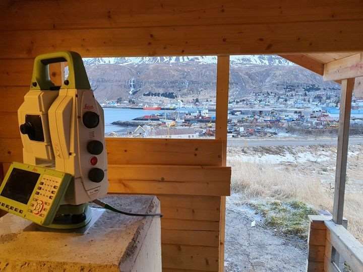
Innovative Edge Computing Technology for Autonomous Monitoring
                                   Systems

                           Lidija ŠPIRANEC and Elias NIEL, Switzerland

       1. INTRODUCTION

   Automated geodetic monitoring systems have been utilized for over 30 years (Brown,
   Kaloustian, & Roeckle, 2007). The rapid pace of world development requires higher safety
   standards than ever, therefore the need for automated monitoring systems is also in constant
   growth. Whether it is monitoring for construction or maintenance purposes, protection against
   natural hazard threats, ground stability in the mining industry or structural health analysis, only
   when the monitoring data is in real-time data can it truly allow for informed and quick decisions.
   Hence, insufficient data or the complete lack of data, whatever its cause may be, can pose a
   severe safety threat if unforeseen movement occurs.

   Similar to the four elements of nature, there are typically four components of automated
   monitoring systems:
      − Monitoring sensors: responsible for generating raw measurements within defined
          intervals. They can be geodetic sensors (e.g. total stations, GNSS, levels), geotechnical
          sensors (e.g. tilt meters, extensometers, piezometers), environmental sensors (e.g.
          weather stations) or remote sensing sensors (radars, InSAR)
      − Power supply: provides power to on-site equipment. The power source must be 24/7
          operational with the availability of a fallback solution (usually a battery). Examples of
          power supplies include mains electricity, solar panels and generators.
      − Communication device: enables near-instantaneous data transfer between the field and
          the office. Regardless of whether the monitoring system is connected to the internet, or
          is only operating within a local area network, communication devices (usually industrial
          routers) represent the bridge between the sensors and monitoring software.
      − Monitoring software: responsible for the processing of measured data from the field
          sensors, it provides near real-time information about movements. Monitoring software
          must be able to automatically detect and inform about displacements outside of defined
          thresholds, as well as provide the overview of historic data to visualise and analyse
          movement trends.

   Each of these components carries its own complexity and can malfunction in its own way, but
   only if all components are seamlessly integrated into the monitoring system, the probability of
   data gaps can be reduced to a minimum.

   This paper presents how the latest technological advancements in Leica Geosystems’
   monitoring solution (Figure 1) ensure continuous and uninterrupted dataflow:

Innovative Edge Computing Technology for Autonomous Monitoring Systems (10996)
Lidija Špiranec and Elias Niel (Switzerland)
FIG e-Working Week 2021
Smart Surveyors for Land and Water Management - Challenges in a New Reality
Virtually in the Netherlands, 21–25 June 2021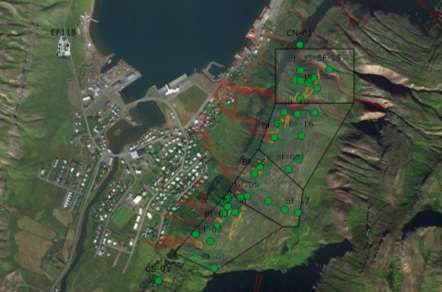
− Leica TM60: a total station specifically built for the purpose of 24/7 monitoring. Its
         technical solutions and robustness allow for highest measurement success rate with the
         longest maintenance intervals among total stations.
       − Leica GeoMoS Edge: the edge computing technology, which is responsible for the
         autonomous execution of the measurement cycles and local data storage in case of
         communication failure.
       − EdgeConnect technology, powered by Hexagon’s Xalt: technology which enables
         secure IoT connectivity between the monitoring sensors in the field and the Leica
         GeoMoS Monitor monitoring software.

                                 Figure 1 Leica Geosystems monitoring solution

       2. AUTONOMOUS MONITORING SOLUTION

   An autonomous monitoring solution refers to a monitoring system which continues being fully
   operational in case of communication or power failure, or both. While failures of the main
   power source can easily be overcome by having a secondary power source (e.g. internal or
   external battery, generator), communication failure implies that the execution of the
   measurement cycles must proceed without the feedback from the monitoring software.
   Therefore, the equipment in the field must possess its own intelligence, in order to be able to
   autonomously proceed with data acquisition and adapt to potential changes in the environment.

       2.1 Monitoring Total Station

   The new Leica TM60 (Figure 2) is a self-learning monitoring total station, that can adapt to the
   environmental conditions and automatically measure targets farther away than traditional
   surveying total stations. It is equipped with the latest Leica Captivate onboard software, where
   environmental specific configurations do not have to be set. This allows to speed up the
   measurement frequency in monitoring applications and decreases the number of bad or failing
   measurement attempts as it automatically adapts to changing environmental conditions, which
   can happen during regular monitoring cycles.

Innovative Edge Computing Technology for Autonomous Monitoring Systems (10996)
Lidija Špiranec and Elias Niel (Switzerland)
FIG e-Working Week 2021
Smart Surveyors for Land and Water Management - Challenges in a New Reality
Virtually in the Netherlands, 21–25 June 2021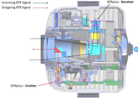
This is possible with the image-based ATRplus technology for
   target recognition and measurements. It consists of an active
   laser source in the telescope, which emits a coaxial infrared
   beam that will be reflected by the target. A CMOS sensor,
   functioning as a passive receiver unit in the telescope detects
   the reflected signal, which is appearing as a light spot on the
   camera sensor (Figure 3). In the first step software algorithms
   analyse and process this image to classify the light spot as a
   surveying target. Hence the emitted laser energy is varied and
   regulated to improve the spot quality on the CMOS sensor in
   terms of saturation and sharpness. This is based on the distance,
   and moreover the environmental conditions, which have a big
   influence on the laser beam. During this process the parameters,     Figure 2 The latest monitoring
   which used to be configured by the “visibility settings” in the      total station, Leica Nova TM60
   predecessor of the TM60 – the TM50, are derived and automatically applied by the self-learning
   ATRplus. Thus, the user does not have to decide between “Good”, “Rain & Fog” or “Sun &
   Reflection” to get the best performance for the automatic target recognition (Grim et al., 2015).
   The Leica TM60 is the first monitoring total station using this technology.

                       Figure 3 Optical path of ATRplus signals inside the TM60 telescope

   Additionally, also non-target reflections can be detected and rejected. To reject a foreign signal,
   such as headlights or bright sunlight, which might appear within the field of view of the
   telescope, the ATRplus technology uses the so-called “BiDi-Mode” during the target search.
   This mode regulates the laser emitter in such way, that alternating bright- and dark images can
   be recorded by the receiver. An active foreign light source (e.g. sunlight – not only direct, but
   also deviated through mirroring effects of metal, water, or windows) appears the same in both         3

Innovative Edge Computing Technology for Autonomous Monitoring Systems (10996)
Lidija Špiranec and Elias Niel (Switzerland)
FIG e-Working Week 2021
Smart Surveyors for Land and Water Management - Challenges in a New Reality
Virtually in the Netherlands, 21–25 June 2021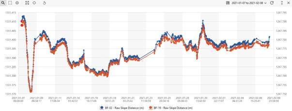
kinds of images, however a passive reflector, like a monitoring prism appears differently in the
   respective images (Figure 4). This enables that similar light spots on the CMOS sensor can be
   classified as correct monitoring prisms.

                Figure 4 Bright (left) and dark (right) ATRplus image of a car and a reflective prism

   While ATRplus has been well established in classical surveying total stations and
   MultiStations, it is now also available for long-range measurements up to 3000 meters in the
   TM60 monitoring total station. This is achieved with a special lens system focusing the emitted
   laser energy in a narrow beam, allowing longer measurement ranges. This comes with a smaller
   field of view for automatic target aiming which can be an advantage when having multiple
   prisms close to each other in a far range. The Leica TM60 also can measure prisms with an
   angular accuracy of 0.5”. This is achieved by the combination of a quadruple head angle-
   measurement system on the Hz- and V-Axis, an internal inclination sensor and the automatic
   target measurement of the ATRplus. Crucial is the possibility of determining the centre of the
   light spot on the CMOS sensor with sub-pixel accuracy. This centre point is then known in pixel
   coordinates of the CMOS sensor which then are applied with the known sensor-offsets to the
   centre of the optical axis.

   The Leica TM60 is also equipped with a Piezo-Drive system. This ensures smooth long-term
   operation, reliability and stability independent of the surrounding conditions (Grimm et al.,
   2013). The distance measurement module is based on the traditional and highly accurate phase-
   shift comparison technology – the Leica PinPoint distance measurement system. Additionally,
   the Imaging variant of the Leica TM60 is equipped with an overview camera and an on-axis
   camera in the telescope suitable for camera based aiming (“see what the total station sees”), for
   photo documentation as well as the possibility to perform photogrammetric tasks in post
   processing.

   Automatic point learning (AutoLearn) is another monitoring-specific innovation for total
   stations. It enables all targets in a defined area to be rapidly detected, measured and learned.
   This feature is available only for the Leica TM60 instruments and it is particularly important
   during the first setup of the monitoring system, but also when additional prisms are being
   installed. Automating point learning is a big step forward in geodetic monitoring because
   human errors, like omitted points, are eliminated by using ATRplus technology.

Innovative Edge Computing Technology for Autonomous Monitoring Systems (10996)
Lidija Špiranec and Elias Niel (Switzerland)
FIG e-Working Week 2021
Smart Surveyors for Land and Water Management - Challenges in a New Reality
Virtually in the Netherlands, 21–25 June 2021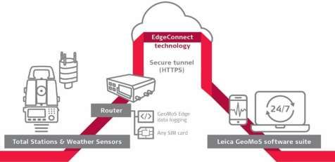
AutoLearn is utilized through the GeoMoS Monitor software. The simplest procedure to learn
   new points is by using the cameras on the instrument; either the overview camera or the
   telescope camera with 30x magnification. The live video stream from the camera can be used
   to position the instrument in the wanted direction. In the next step, an image of that area is
   captured and a rectangular search area is drawn on the image. Next, the TM60 performs a search
   within the defined area (Figure 5), according to the preconfigured settings. Once the search has
   been completed, there is a report of the number of prisms found in that area and the number of
   prisms which are new in that monitoring project. In the case of using a TM60 variant without
   cameras or when measuring in darkness, AutoLearn can still be performed based on the angular
   values (azimuth and vertical angle) of the extents of the search area. The prerequisite of this is
   that the instrument’s orientation must be known.

         Figure 5 Leica TM60 conducting the prism search within a defined area. The configuration was
           Edge
         done usingComputing   in Monitoring
                    GeoMoS AutoLearn  feature.

       2.2 Edge Computing in Monitoring

   The software component of most monitoring systems is usually a standalone or cloud
   deployment of the specialized monitoring software, which acts as a server. Having a direct
   communication between the sensors and the server allows many benefits, including repeated
   measurements of points and real-time warnings where the defined limits were exceeded, but it
   also displays weakness in its dependency on stable communication component. This means that
   with every communication outage, measurements cannot be carried out, which produces data
   gaps and therefore becomes a safety threat. For that reason, monitoring systems must be able
   to run autonomously for a certain period of time, to persevere with data acquisition. This,
   however, is not a permanent solution, as complete detachment from the server also has a
   consequence of losing real-time information and notifications in case of detected movements.
   GeoMoS Edge provides the autonomous solution, by having the data acquisition component
   replicated from the server and embedded on a communication device. Its functionality is to
   perform the configured measurement cycle, compute the raw measurement data quality and,
   based on it, trigger the repeated measurements and finally, to deliver the measured data to the
   monitoring office software – Leica GeoMoS Monitor. GeoMoS Edge currently supports Leica
   total stations, MultiStations and weather sensors. Leica total stations can perform prism            6

Innovative Edge Computing Technology for Autonomous Monitoring Systems (10996)
Lidija Špiranec and Elias Niel (Switzerland)
FIG e-Working Week 2021
Smart Surveyors for Land and Water Management - Challenges in a New Reality
Virtually in the Netherlands, 21–25 June 2021
measurements, as described in (Lehmuller, 2016), reflectorless measurements and take images
with defined schedules, while MultiStations can also automatically scan predefined areas, as
described in (Wöllner, 2017). Weather sensors cater for general information about
environmental conditions, but also provide crucial data for meteorological corrections of total
station slope distance measurements.
Figure 6 Measurement process with GeoMoS Monitor and GeoMoS Edge
The workflow (Figure 6) starts with configuring the measurement cycle in Monitor, which then
sends the configuration to GeoMoS Edge. In case of communication failure, data acquisition
will persist autonomously, based on the last available configuration and measurements will be
stored locally until the communication with the server (GeoMoS Monitor) is restored. This
means that data gaps due to communication failure are eliminated.
2.3 Secure Data Transfer
Communication protocols between the field and the office must fulfil the highest security
requirements, due to the sensitivity of monitoring data, as well as the overall security of the
local network the server belongs to. This can be achieved with special IT configuration, which
typically requires involvement of IT experts. A secure communication is achieved using either
VPN technology or by configuring firewall settings (static IP address, inbound and outbound
rules in the PC and the communication device). This process adds complexity to the monitoring
installation, which can make it costly and time consuming, therefore increasing the time until
monitoring can start.
EdgeConnect technology, powered by Hexagon’s Xalt, is a cloud service which simplifies this
process. It is integrated into GeoMoS Edge and enables secure cloud IoT connectivity between
the field and the office. EdgeConnect uses a clever pairing procedure between GeoMoS Monitor
and the router, making use of a standard, open HTTPS port, therefore requiring no additional
IT modifications. Once paired, GeoMoS Monitor takes ownership of the device, making it
impossible for the device to be hijacked, or for the data to be stolen. The user has full control
of the device and can move it from one project to another. EdgeConnect removes the IT
complexity from the monitoring installation equation, reduces costs and significantly shortens
the time until monitoring can start.
Innovative Edge Computing Technology for Autonomous Monitoring Systems (10996)
Lidija Špiranec and Elias Niel (Switzerland)
FIG e-Working Week 2021
Smart Surveyors for Land and Water Management - Challenges in a New Reality
Virtually in the Netherlands, 21–25 June 20213. CASE STUDY
The latest monitoring solution from Leica Geosystems described in Chapter 2 was released in
November 2020, but it already has several success stories worldwide. For this article, the focus
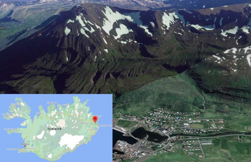
is on the monitoring system installed in the remote area of Iceland, to monitor slopes in the
aftermath of landslides, which caused the evacuation of the whole town of Seyðisfjörður (Figure
7).
Figure 7 Location of Seyðisfjörður in Iceland (sources Google Maps and Google Earth)
3.1 Seyðisfjörður Landslides
Located in a narrow fjord in East Iceland, Seyðisfjörður is often lauded as one of Iceland’s most
picturesque towns. From 15th to 18th December 2020, several landslides hit this town,
destroying or damaging more than 10 buildings (Figure 8), with the largest landslide on 18th
December. The latest of which ranks as the most damaging landslide to have affected an urban
area in Iceland. Ahead of the mudslides, intense rainfall had occurred in the area, with 569 mm
of cumulative rainfall between 14th and 18th December – the heaviest rainfall measured over a
five-day period in Iceland. In comparison, the average annual rainfall in Reykjavík is about 860
mm (URL1: Icelandic Met Office, IMO, 2020).
Innovative Edge Computing Technology for Autonomous Monitoring Systems (10996)
Lidija Špiranec and Elias Niel (Switzerland)
FIG e-Working Week 2021
Smart Surveyors for Land and Water Management - Challenges in a New Reality
Virtually in the Netherlands, 21–25 June 2021Figure 8 Damage caused by landslides in Seyðisfjörður (Photos: National Commissioner's Special Forces, URL1)
After the occurrence of landslides, the land continues to adjust for some time, causing further
slope instability, especially during and after rainfall events. The December landslides produced
several cracks on the slopes above the town and the IMO experts noted the importance of setting
up measuring equipment for real-time monitoring of the slopes above the town.
3.2 Installed Monitoring System
Following the events, as an emergency measure, a manually observed prism and total station
scheme was installed. In the early days of January 2021, automated monitoring equipment
arrived at Reykjavík and the IMO surveying engineer travelled to Seyðisfjörður to install it. In
total 34 prisms were mounted on the slope (2 reference points and 32 monitoring points) and
the Leica TM60 I monitoring total station was set up in a stable area more than 1km away from
the slope (Figure 9). The TM60 I – with imaging capabilities, together with a weather sensor,
is connected to a Leica ComGate20 communication device with a SIM card from the local
cellular provider.
Figure 9 Monitoring system in Seyðisfjörður. EF118 is the location of the total station, while green dots
represent the prisms. Red lines depict the outlines of the December landslides.
Innovative Edge Computing Technology for Autonomous Monitoring Systems (10996)
Lidija Špiranec and Elias Niel (Switzerland)
FIG e-Working Week 2021
Smart Surveyors for Land and Water Management - Challenges in a New Reality
Virtually in the Netherlands, 21–25 June 2021To establish an internet connection between the router and GeoMoS Monitor installed at the
IMO office in Reykjavík, following a simple code exchange the hardware was paired using
EdgeConnect technology. Data visualisation and analysis is completed using GeoMoS Now!
service, which is specifically designed to display monitoring data and is available on any mobile
device or PC using a browser.
The installation of the monitoring system was quite challenging, due to the very few hours of
daylight in Seyðisfjörður at that time of the year. The monitoring total station, its survey control
and measurement arrays were commissioned and scheduled in GeoMoS Monitor within two
hours, this mainly thanks to the AutoLearn feature, which automatically found and measured
all 34 prisms in complete darkness. Without this technology, finding and learning the prisms
would have needed to be bound to daylight and it would have been a much more time-
consuming process, as each point would need to be located and measured individually. A
weather sensor is measuring the environmental conditions in the vicinity of the total station,
thus providing the valuable temperature and pressure information, both as meteorological
corrections for total station measurements, as well as for providing weather data.
Figure 10 Leica TM60 I monitoring total station in the measurement hut
The monitoring measurement cycle consists of meteorological and prism measurements at
30min intervals. With the Leica TM60 I (Figure 10), being an imaging variant of the instrument,
to provide added benefit, it automatically captures images of four defined image areas every
hour during the daylight. This assists the IMO team to identify and visually confirm any changes
in the locations between the prisms.
Innovative Edge Computing Technology for Autonomous Monitoring Systems (10996)
Lidija Špiranec and Elias Niel (Switzerland)
FIG e-Working Week 2021
Smart Surveyors for Land and Water Management - Challenges in a New Reality
Virtually in the Netherlands, 21–25 June 20213.3 Data Analysis
For the purpose of this article IMO shared one month of their data, starting with the installation
on 7th of January 2021. During that period, the communication device went offline eight times,
if the changes of status during the configuration are ignored (Figure 11). This means that during
the connection downtime caused by instability of the cellular network signal, GeoMoS Edge
was collecting data autonomously and storing raw measurements locally on the communication
device, fulfilling its design intent of “no data gaps”, which would typically occur if there was
no office to total station communication.
Figure 11 Changes of connection status in the period from January 7 to February 8
Raw measurements collected from the weather sensor are temperature and pressure, whereas
the prism raw measurements are horizontal (Hz) and vertical (V) angle and raw slope distance.
These locally stored measurements were automatically sent to GeoMoS Monitor (server) for
processing immediately after the connection was restored. Figures 12 and 13 display the raw
data availability during the same period. Final system configuration modifications were done
on 15th January, which reduced the noise in total station raw measurements.
Figure 12 Temperature measurements from the weather sensor in the period from January 7 to February 8
10
Innovative Edge Computing Technology for Autonomous Monitoring Systems (10996)
Lidija Špiranec and Elias Niel (Switzerland)
FIG e-Working Week 2021
Smart Surveyors for Land and Water Management - Challenges in a New Reality
Virtually in the Netherlands, 21–25 June 2021The temperature measurements chart (Figure 12) is not displaying data gaps. The range within
the temperature values were measured is between +9.7˚C and -10.6˚C. The prism measurements
chart (Figure 13) for the points BF-02 and BF-19 shows occasional missing measurements, with
the 48h period without measurements from midday 22nd to midday 24th of January 2021.
However, success of electro-optical prism measurements highly depends on environmental
conditions and requires a clear line of sight to the prism. If the line of sight is obstructed (snow,
dirt on the prism or severely inclement weather), the measurement will fail. GeoMoS software
has the intelligence with the option to retry the unsuccessful measurements, as well as
measurements which do not fulfil the required quality, at the end of the cycle. This can increase
the reliability in the system, although it is possible that the obstructed status has not changed.
Figure 13 Slope distance measurements on BF-02, BF-19 points in the period from January 7 to February 8
As the TM60 is scheduled to take images during the daylight hours, that can also be utilised for
environmental condition analysis. Figure 14 is showing the image captures of “StoraSkridan”
image area before (22nd of January at 10:10AM), during (23rd of January at 13:43PM) and after
(25th of January at 11:38AM) the period without measurements. From the images it is clear that
there were severe weather conditions, in which measurements cannot be executed successfully.
On the picture after that period, it is evident that the mountain is covered with more snow than
before, but the air was clear and the total station measurements were successful.
Figure 14 Image captures from the TM60, showing the ”StoraSkridan” image area before, during and after the
blizzard 12
Innovative Edge Computing Technology for Autonomous Monitoring Systems (10996)
Lidija Špiranec and Elias Niel (Switzerland)
FIG e-Working Week 2021
Smart Surveyors for Land and Water Management - Challenges in a New Reality
Virtually in the Netherlands, 21–25 June 2021The World Weather webpage, which keeps weather data archive (URL2: World Weather)
confirmed that there was a blizzard on the 23rd of January in Seyðisfjörður (Figure 15).
Figure 15 Weather in Seyðisfjörður on 23rd January 2021 (URL2: World Weather)
4 CONCLUSION
The purpose of every deformation monitoring system is to inform about the movements in the
monitored area. When data is missing, people and objects in the vicinity could find themselves
in danger, as the real-time notifications would not be triggered. Robustness and resilience of
the highest quality monitoring solutions can be attributed to reliable edge computing
technology. The ATRplus technology within the TM60 monitoring total station automatically
adapts the measurement settings to current environmental conditions and ensures the targets are
measured automatically up to 3,000 m away. GeoMoS Edge communicates with the total station
and executes the measurement cycles, even when it is disconnected from the server. GeoMoS
Edge recognises points which were not measured or were measured with insufficient quality
and will remeasure them automatically at the end of the cycle. GeoMoS Monitor will receive
the data which fulfils the defined quality thresholds, either in real-time or immediately after the
connection to GeoMoS Edge is restored. EdgeConnect technology provides simple and secure
communication between Edge and Monitor, whereas AutoLearn ensures the most timesaving
and the only automatic target learning solution in the market.
Monitoring technology is continuously advancing and enables new solutions for the market.
Developing robust monitoring sensors and adding intelligence both to hardware and software,
enhances geodetic monitoring solutions, but there are measurement methodology constraints
which still cannot be overcome. For electro-optical measurements with total stations, the
constraint lies in its line of sight. Obstructions like unclean or snow-covered prisms, as well as
severe weather conditions (fog or blizzard), can all cause failed measurements. The only
solution for these impediments is adding different measurement methodology to the project,
e.g. GNSS or geotechnical sensors. Monitoring sensors and software must cooperate and be
able to adapt to any change in the environment to achieve the ultimate goal of preventing data
loss. Only when data is available, the hazard of the monitored object can be ascertained.
Innovative Edge Computing Technology for Autonomous Monitoring Systems (10996)
Lidija Špiranec and Elias Niel (Switzerland)
FIG e-Working Week 2021
Smart Surveyors for Land and Water Management - Challenges in a New Reality
Virtually in the Netherlands, 21–25 June 2021REFERENCES
Brown, N., Kaloustian, S., & Roeckle, M. (2007), Monitoring of Open Pit Mines using
Combined GNSS Satellite Receivers and Robotic Total Stations, International
Symposium on Rock Slope Stability in Open Pit Mining and Civil Engineering,
September 12 - 14 , 2007. Perth, Western Australia.
Grimm, D, Zogg, H.-M. (2013), Leica Nova MS50, White Paper, Leica Geosystems
Grimm, D, Kleemaier, G., Zogg, H.-M. (2015), ATRplus, White Paper, Leica Geosystems
Lehmuller, K. (2016), Ensuring smooth flow through a busy canal, GEO:CONNEXION,
April 2016, pp. 33-35.
URL1: Icelandic Met Office, accessed 12 February 2021,
URL2: World Weather, accessed 12 February 2021,
Wöllner, J. (2017), Automatisches Monitoring mit robusten Deformationsergebnissen aus
automatisierter Scananalyse, 18. Internationaler Ingenieurvermessungkurs Graz, 2017
BIOGRAPHICAL NOTES
Dr. Lidija ŠPIRANEC is a Senior Product Engineer in the Monitoring Product Management
group at Leica Geosystems. She received her Ph.D. in geodesy and geoinformatics from Faculty
of Geodesy at the University of Zagreb, Croatia.
Mr. Elias NIEL is a Product Engineer in the TPS Product Management group at Leica
Geosystems. He received his M.Sc. degree in Surveying and Geoinformation from the Vienna
University of Technology, Austria.
CONTACTS
Dr. Lidija Špiranec
Leica Geosystems AG
Heinrich-Wild-Strasse
Heerbrugg
SWITZERLAND
Tel. +41 71 727 3459
Email: lidija.spiranec@leica-geosystems.com
Web site: https://leica-geosystems.com/
Mr. Elias Niel
Leica Geosystems AG
Heinrich-Wild-Strasse
Heerbrugg
Innovative Edge Computing Technology for Autonomous Monitoring Systems (10996)
Lidija Špiranec and Elias Niel (Switzerland)
FIG e-Working Week 2021
Smart Surveyors for Land and Water Management - Challenges in a New Reality
Virtually in the Netherlands, 21–25 June 2021SWITZERLAND Tel. +41 71 727 4758 Email: elias.niel@leica-geosystems.com Web site: https://leica-geosystems.com/ Innovative Edge Computing Technology for Autonomous Monitoring Systems (10996) Lidija Špiranec and Elias Niel (Switzerland) FIG e-Working Week 2021 Smart Surveyors for Land and Water Management - Challenges in a New Reality Virtually in the Netherlands, 21–25 June 2021
You can also read