Google Street View Images Support the Development of Vision-Based Driver Assistance Systems
←
→
Page content transcription
If your browser does not render page correctly, please read the page content below
Google Street View Images Support the Development of
                       Vision-Based Driver Assistance Systems
                                    Jan Salmen∗ , Sebastian Houben∗ , and Marc Schlipsing∗

   Abstract— For the development of vision-based driver as-
sistance systems, large amounts of data are needed, e. g.,
for training machine learning approaches, tuning parameters,
and comparing different methods. There are basically three
possible ways to obtain the required data: using freely available
benchmark sets, doing own recordings, or falling back to
synthesized sequences. In this paper, we show that Google
Street View can be incorporated as a valuable source for image
data. Street View is the largest publicly available collection
of images recorded from a drivers’ perspective, covering many
different countries and scenarios. We describe how to efficiently
access the data and present a framework that allows for virtual
driving through a network of images. We assess its performance
                                                                         Fig. 1.  Availability of Google Street View images, January 2012
and show its applicability in practice considering traffic sign
                                                                         (http://support.google.com).
recognition as an example. The introduced approach supports
an efficient collection of image data relevant to training and
evaluating machine vision modules. It is easily adaptable and
extendible, whereby Street View becomes a valuable tool for                 Synthesized sequences are also used in practice as they
developers of vision-based assistance systems.                           allow to simulate driving long distances at low cost. They
                                                                         are particularly helpful for the evaluation of optical flow
                     I. INTRODUCTION
                                                                         and stereo approaches, where ground truth data is very hard
   Several vision-based assistance systems are already avail-            to obtain for real-world videos [7][8]. Nevertheless, for the
able in mass production vehicles today, e. g., lane detection,           development of security relevant systems one cannot rely
traffic sign recognition, and obstacle avoidance. Many more              exclusively on simulated data.
will follow within the next years, contributing significantly               We argue that the retrieval of images from Google Street
to the evolution of intelligent vehicles towards fully au-               View is a powerful alternative, especially in earlier stages of
tonomous vehicles.                                                       development: Huge amounts of image data are available for
   The development of vision-based modules typically re-                 many different countries all over the world (see Fig. 1) and
quires large amounts of data: Machine learning approaches                they can be accessed easily and efficiently – as we showcase
for object detection and recognition have to be trained.                 in this paper.
Parameter tuning for different scenarios can either be done                 Thinking of the different types of vision-based algorithms
manually or automatically. Finally, algorithms’ performance              needed for intelligent vehicles, Google Street View record-
have to be assessed on additional test data, that was not                ings do not satisfy all of them equally well. As the available
involved in the process of training or parameter optimization.           images feature a relatively coarse temporal resolution, ap-
   Collecting appropriate data is often more time-consuming              proaches relying on high frame rates (e. g., estimation of
and more expensive than the algorithm development itself.                optical flow) cannot be applied reasonably. Nevertheless,
This holds even more if data from other countries has to                 the data can be very useful for the development of object
be considered, e. g., to test the transferability of an existing         detection and recognition algorithms.
module or to evaluate approaches for new scenarios.                         Of course, relevant data is not annotated in Street View
   Instead of recording and annotating hours of driving                  images – i. e., identification (labeling) of relevant objects.
by oneself, sometimes publicly available data sets can be                This would be done manually as it is common for recorded
useful. However, there are only a few, e. g., for pedestrian             videos. Nevertheless, as the new approach presented here
detection [1][2][3], traffic lights detection [4], traffic sign          allows accessing a huge amount of video data, it is inappro-
recognition [5], and stereo vision [6]. Thinking of traffic              priate to examine all images. Rather, this demands iterative,
sign recognition, for instance, only Germany is covered so               semi-supervised, and therefore semi-automatic approaches to
far. Furthermore, these datasets were usually recorded with a            object detection.
specific goal and may not be applied on other, even similar,                In this paper, we describe the basic principles needed for
problems.                                                                accessing Google Street View data from own applications
  ∗ J. Salmen, S. Houben, and M. Schlipsing are with the Institut für   (Sec. II). Section III presents our framework that allows
Neuroinformatik, Ruhr-Universität Bochum, 44780 Bochum, Germany         virtual driving through arbitrary regions in order to collect
firstName.lastName@ini.rub.de                                            data and evaluate algorithms. We conducted experiments
B. XML
                                                                         . . . output=xml&ll=[LAT,LNG]
                                                                            Using this request, one can receive additional information
                                                                         for a panorama image in XML format, e. g., place and
                                                                         recording time. For our purposes, the most important entries
                                                                         are the so called pano ids. This is a unique identifier
                                                                         for the current panorama, but additional IDs are given for
                                                                         the adjacent panoramas, i. e., on the same road and / or for
 Fig. 2.   Example of a thumbnail image obtained using the static API.   crossing roads. Those entries are called links.
                                                                            It is noteworthy that also the street type (e. g. highway,
                                                                         rural road, inner city, etc.) can be derived from the XML
concerning performance and characteristics of the framework
                                                                         data (entry road argb), allowing for specialized processing.
(Sec. IV). As an example of use, we considered the collection
of traffic sign images for detection and recognition (Sec. V).
Finally, results are discussed in Sec. VI.                                                          TABLE I
                                                                         Z OOM LEVELS AVAILABLE IN THE S TREET V IEW STATIC API, NUMBER
    II. THE GOOGLE STREET VIEW STATIC API
                                                                                    OF TILES , AND RESULTING PANORAMA IMAGE SIZES .
   The image database of Google Street View is a network
of adjacent 360◦ high resolution panorama images, which                            Zoom level    Number of tiles     Resulting   image size
are divided into quadratic tiles. Those images are intended                            0            1 ×1                  512    × 256
                                                                                       1            2 ×1                1,024    × 512
to be accessed via the Google Maps static application pro-                             2            4 ×2                2,048    × 1,024
gramming interface (API). In order to make them usable                                 3            8 ×4                4,096    × 2,048
for algorithm development, some undocumented features                                  4           16 × 7               8,192    × 3,584
                                                                                       5           28 × 13             14,336    × 6,656
have to be considered. Many of the technical details have
been described recently by Jamie Thompson in his weblog1 .
Images from Google Street View have also been considered
for research projects in other domains [9][10].
   It is not completely clear that the presented way of usage
is compliant with Google’s terms of service2 (for additional
information, also see the related FAQ3 ). However, accessing
the provided data conforms to the conditions, as long as
no copies or modified versions of the electronic content
are published. In particular, Google grants unlimited and                Fig. 3.   Tiles in the panorama image (Fig. 2) for zoom levels 3, 4, and 5.
free access to the Google Maps API for “non-profits and
applications deemed in the public interest”, e. g., universities.
For the reasons discussed above, we are not going to publish             C. Tile
data sets extracted from Google Street View for now.
   The undocumented API features mentioned above are                     . . . output=tile&panoid=[ID]&zoom=[Z]&x=[X]&y=[Y]
some simple HTTP requests to cbk0.google.com/cbk                            Given the panorama ID, we are able to access the
along with some parameters. For the sake of                              panorama image using this ID in the request above instead
completeness, we introduce all four known commands                       of GPS coordinates. In contrast to the thumbnails mentioned
below, which are simply attached to the prefix                           in Sec. II-A, larger images are divided into tiles of size
http://cbk0.google.com/cbk?. . . (i. e., HTTP GET).                      512 × 512 pixels which have to be requested indepen-
For now, two of them are used by the current framework.                  dently specifying their relative positions X and Y within the
                                                                         complete image. Additionally, six different zoom levels (Z
A. Thumbnail from GPS coordinates                                        ∈ [0, . . . , 5]) are made available. Table I gives an overview
. . . output=thumbnail&w=[SX]&h=[SY]&ll=[LAT,LNG]                        of the number of tiles and the resulting image size. Figure 3
   This request requires GPS coordinates (latitude LAT and               illustrates some example tiles from different zoom levels. In
longitude LNG). If a Street View panorama image close to the             the largest level, a panorama image with an amazing number
defined position is available, a thumbnail image of size SX              of 90 mega pixels can be accessed.
× SY in JPEG format is returned. The maximum possible
size is 300 × 128 pixels. The thumbnail shows the full 360◦              D. Thumbnail from ID
panorama, see Fig. 2 for an example.
                                                                         . . . output=thumbnail&w=[SX]&h=[SY]&panoid=[ID]
  1 http://jamiethompson.co.uk/web/2010/05/15/
google-streetview-static-api
                                                                           This does basically the same as II-A, returning a thumbnail
  2 http://www.google.com/intl/en ALL/help/terms maps.html               image, but taking a panorama ID instead of GPS coordi-
  3 http://code.google.com/intl/en/apis/maps/faq.html                    nates.
possibilities for later processing. The algorithm has to keep
track of all panorama IDs that already have been visited (list
visitedIds) to avoid circular routes. If a node is visited for
the first time and is contained in the search area (line 11), the
corresponding XML data is requested. It is always followed
the first link and the rest is stored in a stack (storedIds).
The algorithm stops if all reachable nodes inside the search
area have been visited (line 5). Note that this does not
necessarily mean that all roads have been considered – this
requires a path to the starting point that lies completely inside
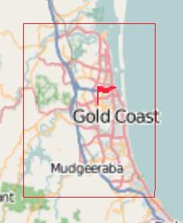
Fig. 4. User interface of our framework. the search area.
If the result data is to be stored locally (cf. Sec. V), a save
path for images and / or a database can be specified. We are
III. FRAMEWORK FOR VIRTUAL DRIVING planning to extend the framework by the support of plug-ins,
allowing to customize and extend the system dynamically at
Based on the interface described in the last section, a
runtime.
framework that allows for virtual driving in Google Street
View was developed. The system is operated through a IV. EVALUATION
graphical user interface shown in Fig. 4. The user is able
to scroll and zoom a map realized with the freely available The performance of the proposed framework is measured
Marble4 toolkit. The interface features the choice of a with respect to different quantities: What distance can be
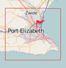
starting point, the definition of a rectangular search area virtually covered per hour? How many panorama images are
and a visualization of the recent path. The map material is available meanwhile? How does the proposed search algo-
based on the publicly available OpenStreetMap data which rithm perform regarding runtime complexity and memory
might in principle deviate from the GoogleMaps coordinates. consumption? Moreover, we are interested in details con-
However, we did not experience any significant inaccuracies. cerning coverage and density of Street View within certain
After initialization, the virtual drive can be started. It areas or street types.
follows the logic documented in pseudo-code in algorithm 1.
We make use of a depth-first-search algorithms, that is,
always following the first possible branch, storing other
4 http://edu.kde.org/marble
Algorithm 1: Pseudo-code for virtual driving
Input: GPS coordinates (X, Y) of starting point and
rectangular search area
1 currentId ← getPanoIdForGpsCoordinates(X , Y );
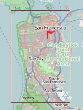
2 Repeat Fig. 5. Regions considered for an initial evaluation of our framework.
3 if contains(visitedIds, currentId ) then
4 if isEmpty(storedIds) then
5 STOP ; TABLE II
R ESULTS OF EVALUATION CONSIDERING REGIONS FROM F IG . 5.
6 else
7 currentId = dequeue(storedIds); City Distance [km] #Panoramas Time [h]
San Fransisco, USA 3023.8 268,127 10:03
8 else Penghu Islands, Taiwan 514.8 44,736 1:41
9 if isInsideSearchArea(currentId ) then Port Elizabeth, South Africa 2105.1 175,369 5:58
Belo Horizonte, Brazil 1426.3 128,459 4:33
10 append (visitedIds, currentId ); Alcalá de Henares, Spain 409.9 32,645 1:01
11 xmlData ← requestXmlData(currentId ); Gold Coast, Australia 2509.8 219,558 8:34
12 links ← linksFromXml (xmlData);
13 currentId ← links[0 ]; In order to obtain baseline results, we only access XML
14 for i ← 1 to i < numberOf (links) do data in our first experiment (i. e., we skip lines 16 and 17 of
15 enqueue(storedIds, links[i ]); the pseudo-code given in algorithm 1). We selected several
16 img ← requestImage(currentId ); cities from different continents, specifying start point and
17 process(img); search area (see Fig. 5) and collected relevant statistics over
time. All experiments were conducted on a standard desktop
PC (Intel Xeon W3520 CPU, 6 GB RAM) with a broadband
×104 number of nodes visited
×103 number of nodes in queue
3 traffic signs had to be labeled (semi-)manually in order to
20 obtain the final dataset (we refer to [5] for more details).
15 2 Therefore, it cannot be expect to have similar datasets for
many other countries in the near future. Nevertheless, it
10 would be very useful to see how far results for detection
1
5 and classification of German traffic signs transfer to other
countries having different signs types (e. g. different shapes,
0 0 colors, pictograms, etc.).
0 1 2 3 4 5 6 7 8 9 The following experiment wants to show that the presented
time [h]
framework can be used to collect a large amount of data –
Fig. 6. Detailed performance analysis of virtual driving on Gold Coast,
Australia. similar to that of GTSRB – with significantly less effort.
A. Setup
connection (download speed approx. 5,000 kb / s). The results In order to detect traffic signs in Street View images,
are given in Tab. II. we used the approach proposed by Viola and Jones [11],
Compared to real-world recordings the effort and costs arguably the most popular real-time object detection frame-
of ’virtual driving’ is very low and the data acquisition is work. This detector is typically applied based on Haar-like
very fast, e. g. the mean virtual driving speed on our system features (see Fig. 8), simple filters which can be evaluated
was at 300 km / h. The mean distance between two panorama very cheaply using a pre-calculated integral image. It is
images amounted to 11.5 m, while no significant differences noteworthy that Haar features can also be employed for other
between the probed cities could be determined. vision tasks in intelligent vehicles, e. g., estimation of optical
Detailed statistics for the virtual trip at Gold Coast, flow [12] and, therefore, allow for a universal preprocessing.
Australia are given in Fig. 6. The number of visited nodes
develops almost linearly over time. The slight flattening that
can be observed is very probably due to the increasing
number of stored panorama IDs that have to be processed
Fig. 8. Basic types of Haar wavelet features used for the Viola-Jones
(see algorithm 1, line 3). The number of IDs stored for later detector.
processing first increases quite constantly up to 2,900 and is
then worked through. For the purpose of minimizing manual efforts, we propose
If images are to be accessed, the resulting performance a semi-supervised training procedure. An initial detector is
also depends on the processing that is done on the images, trained based on an available, small dataset and is then
as well as on the considered zoom level. Therefore, the applied to some Street View images. The extracted detections
hardware used and the internet connection available can limit are manually sorted in three categories: positive (i. e., images
processing speed. In the following section, we consider a showing traffic signs), negative, and unfeasible. The latter
more complex example. category applies to images that feature similar characteris-
V. EXAMPLE OF USAGE tics than the positive examples, but that are not explicitly
searched. The positive and negative images are added to
The “German Traffic Sign Recognition Benchmark”
the initial training set and the detector is trained anew.
(GTSRB) presented in [5] is a single-image classification
This procedure can be repeated several times, increasing the
benchmark incorporating more than 40 sign classes. It com-
detector’s performance iteratively.
prises more than 50,000 images originating from over 1,700
The only crucial point is how to obtain the data for
real-world traffic signs (see Fig. 7). During the first compe-
the very first detector training. For the example considered
tition phase, almost 200 results were submitted5 , reflecting
here, images from the GTSRB dataset were used as positive
the vivid interest in this topic.
examples and randomly chosen images from Street View as
negative examples. We will discuss this issue in the next
section.
For this experiment, we accessed panorama images of
zoom level 3, which translates to a resolution of 3,072×1,536
pixels. For finding traffic signs it is sufficient to consider a
third of the vertical resolution, discarding top and bottom
Fig. 7. Example images from the GTSRB benchmark. parts.
B. Results
While benchmarks like GTSRB can obviously have great
impact, it took our group several months to collect this In contrast to the first evaluation presented in Sec. IV,
amount of data – in fact, more than 150,000 images of we retrieved and processed panorama images here, resulting
in a significant decrease of virtual driving speed to approx.
5 http://benchmark.ini.rub.de 40 km / h on the test system.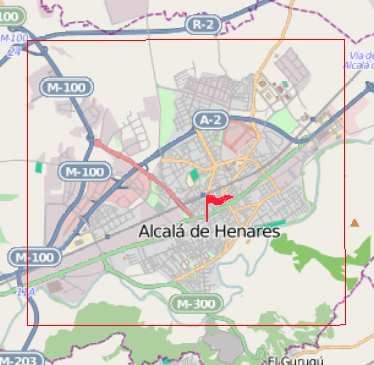
We were able to collect more than 10,000 images of traffic        used, appropriate image sequences have to be recorded. This
signs within a single week. It is noteworthy that using Street       can be very time consuming and expensive – and one can
View, typically less than five images are obtained from each         assume that this hinders the development of new assistance
real-world traffic sign instance. This means in reverse that         systems.
the 10,000 new images already cover more different sign                 We propose the use of images from Google Street View
instances than the original GTSRB dataset.                           in order to support the processes of machine learning from
   Beside the raw number of retrieved images, the perfor-            examples and algorithm evaluation. As driving and recording
mance of the final Viola-Jones detector can be measured              already have been done, it becomes much easier for scientist
regarding precision and recall. Therefore, an amount of              and developers to train and test their approaches on large
2,000 panorama images were assessed manually, resulting in           data sets covering different countries.
a precision of 49.3 % and a recall of 81.6 %. Thus, only half           In this paper, we explained in detail how the image data
of the detections are false alarms, while the major amount           can be accessed through the static API provided by Google.
of the traffic signs have been found.                                This is permitted (at least tolerated) in particular for non-
                                                                     profit institutions. We presented a framework allowing for
C. Discussion                                                        virtually driving through the Street View image data network
   The application of Street View as a data pool for training        and assessed its performance. Using a desktop PC, several
and testing of image-based machine learning algorithms               hundreds of kilometers can be processed on a single day.
includes several caveats that one should take care of to avoid          The gained image data is versatilely usable, e. g., for train-
statistically biased results.                                        ing and testing object detection and recognition algorithms
   Firstly, we point out that the available data itself is biased.   and, thus, denote a highly valuable support for their further
The recordings were predominantly made during daytime                development. In future work, we plan to collect datasets for
with stable weather conditions. We note, however, that this          object detection and classification (e. g., traffic signs, traffic
argument is valid for several published benchmark datasets           lights, cars) in different countries.
as well.
   Secondly, there is no context between recordings. There                                        R EFERENCES
are only few recordings of the same object and sometimes              [1] P. Dollár, C. Wojek, B. Schiele, and P. Perona, “Pedestrian detection:
                                                                          A benchmark,” in Proceedings of the IEEE Conference on Computer
acquisitions were done months apart even with connected                   Vision and Pattern Recognition, 2009, pp. 304–311.
panoramas. Therefore, any algorithms can only work on                 [2] M. Enzweiler, A. Eigenstetter, B. Schiele, and D. M. Gavrila, “Multi-
single images.                                                            cue pedestrian classification with partial occlusion handling,” in Pro-
                                                                          ceedings of the IEEE Conference on Computer Vision and Pattern
   The third caveat concerns the systematics. A data set of               Recognition, 2010, pp. 990–997.
this size has to be processed automatically. Possible results         [3] C. Keller, M. Enzweiler, and D. M. Gavrila, “A new benchmark
(e. g., image sections) can be annotated manually afterwards              for stereo-based pedestrian detection,” in Proceedings of the IEEE
                                                                          Intelligent Vehicles Symposium, 2011, pp. 691–696.
to gradually improve the performance. This systematically             [4] R. de Charette and F. Nashashibi, “Real time visual traffic lights
excludes false negative examples from the training or test                recognition based on spot light detection and adaptive traffic lights
data.                                                                     templates,” in Proceedings of the IEEE Intelligent Vehicles Symposium,
                                                                          2009, pp. 358–363.
   This is the severest argument that we want to address              [5] J. Stallkamp, M. Schlipsing, J. Salmen, and C. Igel, “The German
carefully. Possibilities to circumvent biased training are semi-          Traffic Sign Recognition Benchmark: A multi-class classification com-
manual labeling, i. e., the manual annotation of randomly                 petition,” in Proceedings of the IEEE International Joint Conference
                                                                          on Neural Networks, 2011, pp. 1453–1460.
chosen panoramas which can be favored in the training                 [6] S. Morales and R. Klette, “A third eye for performance evaluation
phase, and the use of Street View data as a supplement to                 in stereo sequence analysis,” in Proceedings of the International
a more solid data base. In our example of German traffic                  Conference on Computer Analysis of Images and Patterns, 2009, pp.
                                                                          1078–1086.
signs, we do indeed strongly benefit from the GTSRB dataset           [7] W. van der Mark and D. M. Gavrila, “Real-time dense stereo for
that had already been collected. Nevertheless, this is only               intelligent vehicles,” IEEE Transactions on intelligent transportation
relevant for the very first training stages. If no data had been          systems, vol. 7, no. 1, pp. 38–50, 2006.
                                                                      [8] T. Vaudrey, C. Rabe, R. Klette, and J. Milburn, “Differences between
available, one could have collected a few training examples               stereo and motion behaviour on synthetic and real-world stereo se-
manually from Street View panorama images or any other                    quences,” in Proceedings of the Conference on Image and Vision
image source.                                                             Computing New Zealand. IEEE Press, 2008, pp. 1–6.
                                                                      [9] B. Micusik and J. Kosecka, “Piecewise planar city 3d modeling
   We therefore argue that due to its tremendous size and                 from street view panoramic sequences,” in Proceedings of the IEEE
nearly effortless access Street View can reasonably improve               Conference on Computer Vision and Pattern Recognition, 2009, pp.
the acquisition of training and test data for video-based driver          2906–2912.
                                                                     [10] A. R. Zamir and M. Shah, “Accurate image localization based on
assistance systems in awareness of the above mentioned                    google maps street view,” in Proceedings of the European Conference
pitfalls.                                                                 on Computer Vision, 2010, pp. 255–268.
                                                                     [11] P. Viola and M. Jones, “Robust real-time object detection,” Interna-
         VI. CONCLUSIONS AND OUTLOOK                                      tional Journal of Computer Vision, vol. 57, no. 2, pp. 137–154, 2001.
                                                                     [12] J. Salmen, L. Caup, and C. Igel, “Real-time estimation of optical flow
  The development of vision-based modules for intelligent                 based on optimized haar wavelet features,” in Proceedings of the In-
vehicles has to rely on large amounts of image data. When                 ternational Conference on Evolutionary Multi-Criterion Optimization,
no data is publicly available and simulated data cannot be                2011, pp. 448–461.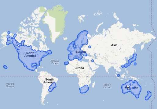
You can also read