Interchange Access Plan - Sydenham - JANUARY 2019 - VERSION 0.20 - Sydney Metro
←
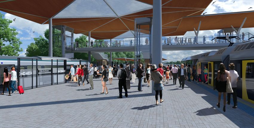
→
Page content transcription
If your browser does not render page correctly, please read the page content below
Interchange Access Plan – Sydenham
JANUARY 2019 - VERSION 0.20

                                INTERCHANGE ACCESS PLAN – SYDENHAM
                                                                     1
Contents

    Sydney Metro.....................................................3                                     Sydenham – interchange and transfer
    Interchange Access Plan issues, assessment and                                                         requirements ................................................... 21
    actions........................................................................................... 3   Overview.....................................................................................21
    Interchange Access Plan purpose...................................... 3                                Walking interchange and transfer requirements........22
    Sydney Metro objectives........................................................ 3                      Cycling interchange and transfer requirements......... 26
                                                                                                           Train interchange and transfer requirements.............. 30
    Interchange and transfer principles............ 4
                                                                                                           Bus interchange and transfer requirements.................32
    Customer-centred design......................................................4
                                                                                                           Vehicle drop-off interchange and
    Sydney Metro customer principles.....................................4
                                                                                                           transfer requirements........................................................... 36
    An integrated customer journey......................................... 5
                                                                                                           Operations, maintenance and
    Access and egress.................................................................... 5                management provisions...................................................... 38
    Modal hierarchy.........................................................................6              Sydenham – actions..............................................................40
    Legislative requirements and applicable guidelines... 8                                                Sydenham – artist’s impression........................................ 43
    Operations and maintenance...............................................9
    Defining the interchange area..............................................9
    Terms and definitions............................................................ 10
    Interchange Access Plans planning conditions............12
    Wayfinding................................................................................ 14
    Consideration of station design and precinct plan.... 14
    Consideration of potential service changes................. 14
    Consultation...............................................................................15
    Regional context – Bankstown to Sydenham.............. 16
    Related projects...................................................................... 16

    Sydenham – local context............................. 18
    Station strategy....................................................................... 19
    Current land use and characteristics............................... 19
    Future land use....................................................................... 20
    Opportunities and constraints.......................................... 20
    Modes without provision..................................................... 20

                                                                                                                                                                                                             Author           Sydney Metro

                                                                                                                                                                                                             Version Number   0.20

                                                                                                                                                                                                             Date             January 2019

                                                                                                                                                                                                             File Name        Sydenham Interchange
                                                                                                                                                                                                                              Access Plan

2   INTERCHANGE ACCESS PLAN – SYDENHAM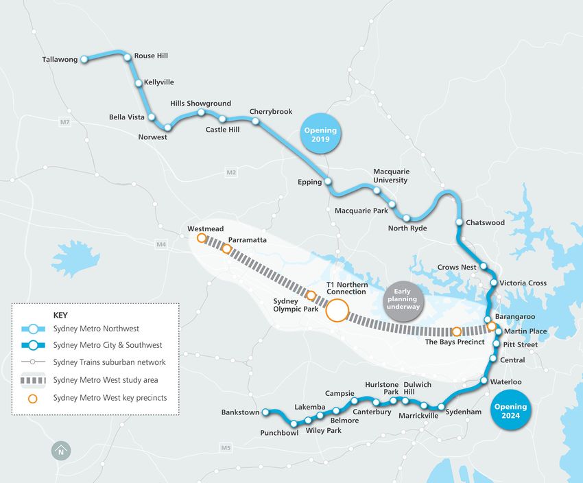
Sydney Metro
Sydney Metro will deliver state-of-the-art rail services across the rail network by addressing current and between Tallawong and Bankstown via the Sydney CBD.
to the people of Sydney and will be the first fully- emerging constraints, including train, platform and The projects include: Interchange Access Plan
automated metro rail system in Australia. Combining station crowding, and network complexity.
best-practice design and operations with the
• Eight new stations between Tallawong and
Cherrybrook, including four kilometres of elevated
purpose
Sydney Metro Northwest, from Tallawong to Chatswood
opportunity to deliver urban renewal and place-making, skytrain between Bella Vista and Rouse Hill.
is the first stage of Sydney Metro, with Sydney Metro The Interchange Access Plan has been prepared to:
Sydney Metro will deliver a step change in the provision
City & Southwest from Chatswood to Bankstown • 15 kilometres of twin tunnels between Bella Vista
of safe and efficient rail services that maximise • Respond to the requirements of the Sydney
included as the second stage. Sydney Metro Northwest and Epping.
customer experience. Metro City & Southwest – Chatswood to
will deliver, for the first time, a reliable public transport • Conversion of five existing stations and the railway
Sydenham conditions of approval.
Together with other projects in Sydney’s Rail Future, service to a region that has the highest car ownership corridor between Epping and Chatswood to
Sydney Metro will support a major increase in the levels per household in NSW. Over the coming decades, metro operations. • Provide detailed interchange deliverables.
capacity of Sydney’s rail network, with a train every an extra 200,000 people will move into Sydney’s north- • Seven new underground stations between Crows • Inform the interchange design of transport and
four minutes during the peak hour and a line capacity west, taking its population above 600,000, or twice the Nest and Waterloo, including 15 kilometres of tunnels. access facilities, including footpaths, cycle paths
of 40,000 passengers per day. The project will size of Canberra. and bike parking, bus stops (temporary transport
• Renewal and conversion of eleven existing above-
significantly improve reliability and service provision requirements considered), and car parking.
Sydney Metro will deliver 66 kilometres of metro rail ground stations between Sydenham and Bankstown
to metro operations. • Identify customer amenities, shelter, and road
and traffic management required to ensure easy,
The conversion of existing railway corridors and accessible, safe and efficient customer transfer
stations to metro operations will include upgrades to when services start in 2024.
platform, overhead electricity and track infrastructure, • Provide a list of actions for delivery partners and
and electronic and communication systems. other stakeholders to enable the implementation
of an easy customer transfer which supports the
Interchange Access Plan issues, project objectives.
assessment and actions
The Interchange Access Plan is provided to inform
The Interchange Access Plan has been developed planning and investment decisions. This document
by applying broad transport and access standards, will be updated in response to station design
guidelines, principles and strategies to the specific as required.
physical and operating environment of the interchange.
It consolidates the requirements and aspirations for Sydney Metro objectives
good customer transfer and identifies potential barriers
or risks to achieving them, considering anticipated The objectives of Sydney Metro are to:
patronage and movement patterns once metro services • Improve the quality of the transport experience
are in operation. for customers.
• Provide a transport system that is able to satisfy
The Interchange Access Plan sets out areas that are
long–term demand.
likely to require attention, either as part of the metro
development or subsequently, and identifies the agency • Grow public transport patronage and mode
or stakeholder responsible for delivering improvements. share.
Some improvements to infrastructure and operations • Support the productivity of the Global Economic
will be made as a direct result of constructing the metro Corridor.
stations and associated works. Any future proposed • Serve and stimulate urban development.
improvements would be informed by further detailed • Improve the resilience of the transport network.
assessment of infrastructure design, capacity and
• Improve the efficiency and cost effectiveness of
condition, guided by the Interchange Access Plan.
the public transport system.
Sydney Metro
INTERCHANGE ACCESS PLAN – SYDENHAM
3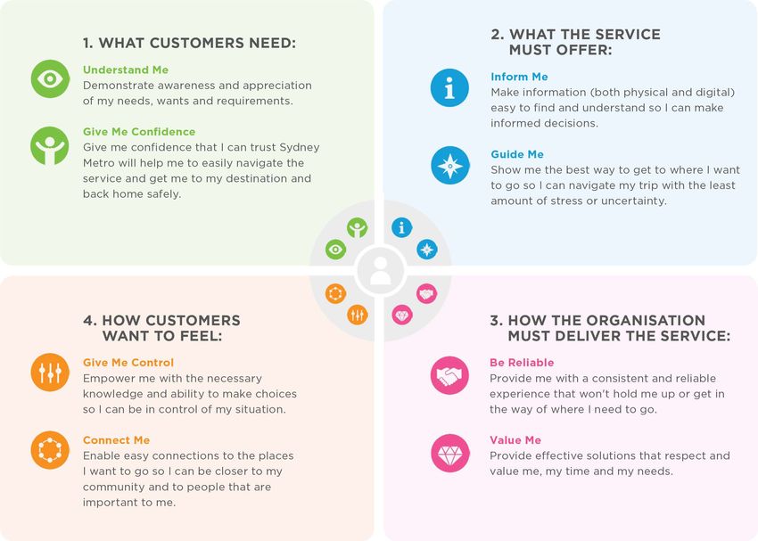
Interchange and transfer principles

    Transport for NSW (TfNSW) is responsible for ensuring the needs of the customer are                                   Sydney Metro provides a customer focus by addressing       The stations, interchanges, trains and complete travel

    at the centre of planning and decision making for the transport system, and that all                                  customer needs at all stages of the journey. A critical    experience all contribute to and will be integral to the
                                                                                                                          principle of Sydney Metro is that every effort will be     customer experience. A high-quality transport product
    projects and services are designed and operated accordingly. This is reflected in the
                                                                                                                          made to make good connections to other modes,              is critical to attracting and retaining customers, and also
    TfNSW mission statement:                                                                                              ensuring easy and quick transfer. It is critical to        to meeting broader transport goals.

    ‘The customer is at the centre of
                                                                                                                          customers that their journey is seamless and well
                                                                                                                                                                                     Linking communities, schools, hospitals, key
                                                                                                                          integrated across all connecting modes and that there
                                                                                                                                                                                     destinations and businesses with the new
                                                                                                                          is easy and safe access to connect to/from the metro.

    everything we do in transport.’                                                                                       At each stage of the journey there are a number of
                                                                                                                                                                                     metro network is key in delivering the easy
                                                                                                                                                                                     customer experience.
                                                                                                                          touchpoints where the customer will interact with
                                                                                                                          a TfNSW product, service, system or is interacting         Sydney Metro customer principles
                                                                                                                          in one of TfNSW’s spaces such as a station or an
                                                                                                                                                                                     The Sydney Metro customer principles inform the
                                                                                                                          interchange or using one of TfNSW’s modes. At these
                                                                                                                                                                                     design, development and operation of the services,
                                                                                                                          touchpoints the aim is to make it easy to interact as
                                                                                                                                                                                     products, systems and spaces to enable customers to
                                                                                                                          well as provide consistency in service delivery and
                                                                                                                                                                                     have an easy and safe customer experience.
                                                                                                                          information, such that it is easy for a customer to have
                                                                                                                          a seamless journey.

    Door-to-door-to-door experience for Sydney Metro

                                                              Metro’s ongoing success and building a solid customer
    Customer-centred design
                                                              base.
    Sydney Metro aims to serve a diverse set of customers
                                                              Customers expect the provision of a service that is on
    who will undertake a number of journeys throughout
                                                              time, clean, safe, comfortable, efficient, convenient,
    the day and week using the metro. The design and
                                                              has the right information and has adequate
    delivery of service is centred around the customer –
                                                              customer service. These basics are key drivers of
    their needs, behaviours, and their jobs to be done.
                                                              customer satisfaction.
    Sydney Metro’s commitment is to deliver a reliable
                                                              Sydney Metro’s goal is to deliver a level of service that
    ‘door-to-door-to-door’ (from origin to destination
                                                              goes beyond satisfaction, makes it easy for customers
    and back again) transport solution (see figure below),
                                                              to use the metro and encourages repeat use across
    which is easy for all customers, by the delivery of
                                                              the multiple types of journeys they may make. This
    a thoughtfully designed, seamlessly integrated
                                                              will support TfNSW’s goal of increasing the number of
    experience that helps move customers around safely,
                                                              journeys taken on public transport by the public, both
    quickly and easily and is adaptive to change. Providing
                                                              in the peak and off-peak periods.
    services centred around the customer is key to Sydney
                                                                                                                          Sydney Metro customer principles

4   INTERCHANGE ACCESS PLAN – SYDENHAM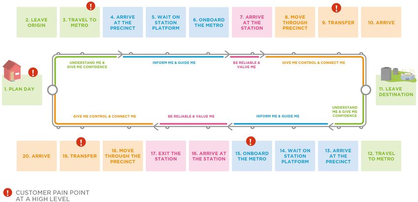
Interchange and transfer principles continued
An integrated customer journey station will vary to the extent that it is a trip origin or In general, stations with high levels of surrounding surrounding residential areas, such as Cherrybrook
destination throughout the day. The diagram on this employment and/or educational institutions, such as and Epping, tend to be origin stations in the morning
Customers see their journey from ‘door-to-door-to- page shows the diverse range of trips to a variety of Norwest or Macquarie University, tend to be destination peak period. This trend reverses in afternoon as people
door’ and may plan and use multiple travel modes land use categories. stations in the morning peak period. Stations with high return to their homes.
throughout their journey in order to achieve their tasks.
It is critical to customers that their journey is seamless
Hills
Showground
Hill
st
and well integrated across all connecting modes, and
Norwe
k
a
Castle
roo
Vist
that access to/from the metro from other modes is
rryb
g
le
easy, efficient and safe.
a
pin
vil
Bell
lly
Che
Ep
rs rie
Ke
ity
ll
ive ua
The Sydney Metro customer journey map captures
Hi
Unacq
e
us
the touchpoints in a customer’s journey from door
M
k
Ro
r
Pa
g
(origin – planning the day) to door (destination) to door
on
ie
w
ar
lla
(return to origin). Key customer satisfaction drivers and qu
Ta
ac de
customer principles that are important to customers M Ry
have been noted at each journey stage. The satisfaction rth
No LEGEND
drivers indicate the service attributes that customers
od Metro Uses
wo
consider most important, what customers believe ats
Ch Access to universities
represents value, and the elements of the transport
Journey to work
experience that contribute to customer satisfaction. st
s Ne
Crow CBD distributor
Customer experience of the transport system is made
up of two core elements – the functional benefit and Local service + shopping trips
the experience of the journey itself. Customer Value Local core employment area trips
a Cross
Victori
Proposition research suggests there are a number of
broad factors that encourage people to use public Land Uses
transport. These factors reflect the trade-offs customers Barangaroo Major commercial
consider when making their travel choices and indicate Major industrial
known customer ‘pain points’ that impact customer Major shops
Martin
interaction with public transport. Sydney Metro must Place
Residential growth area
ensure that these elements are well understood in order
to deliver products, services, systems and stations that Pitt Facilities
Stre
match customer needs and increase its customer base. et Rail interchange
Bus interchange
Access and egress Ce Ferry + bus interchange
ntra
l
Sydney Metro will facilitate a diverse range of trips, Light rail + bus interchange
W
providing not only a fast journey to work but also at Rail + light rail + bus interchange
er
lo
encouraging trips for other purposes such as access o Rail + bus interchange
within the Sydney’s north-west, Sydney’s Global
Sy
B
Entertainment/Recreation
an
de
Economic Corridor, the north-west business park, local
k
n
st
ha
Major hospital
ow
M
m
Pu
or business trips, access to universities and educational
ar
n
n
ric
TAFE
ch
Du
institutions, and service and recreational uses.
kv
b
Hur
Wi
ow
il
lw
le
University
ley
ich
lsto
l
In order to facilitate a range of trips across the
Lak
Canterb
Pa
Hil
ne P
rk
Belmore
multitude of destinations Sydney Metro stations will act
emb
l
Campsie
ark
as both origins and destinations for these trips. Each
a
ury
Sydney Metro trip diversity and accessibility
INTERCHANGE ACCESS PLAN – SYDENHAM
5Interchange and transfer principles continued
Modal hierarchy Transport Description
Station entrance mode
Designing an efficient interchange requires the
allocation of space to different users, according to Pedestrian networks in and around the station must encourage walking, cater for forecast
TfNSW’s modal hierarchy. Wherever possible, this Walking and cycling
demand, minimise delays crossing roads, and provide access to the station and other modes
hierarchy aims to prioritise transfers from more for all (including older people, and people with young families and disabilities, who have greater
equitable and sustainable modes, such as walking safety and mobility needs) in line with Disability Discrimination Act 1992 (DDA) requirements.
Trains
and cycling, over vehicle-based modes, including the Through-site links to stations should be open 24 hours a day (or as long as metro is operating).
provision of supporting infrastructure. The modal Light rail, bus, Pedestrian infrastructure shall be designed to accommodate modelled volumes/demands and to
and ferry
hierarchy used in this plan is consistent with the protect pedestrians from other road users in accordance with relevant Australian Standards, and
transport planning principles defined in the EIS. Austroads and NSW Government guidelines.
Coaches
Due to the location of each station, particularly within For bicycle riders, the interchange must provide safe and clear bicycle access in the vicinity
the Sydney CBD, in general, metro customers are not Taxis of the station, signage and bike parking facilities at stations, in order to encourage cycling to
expected to access the station by driving their car. Sydney Metro.
No car parking is to be provided at any of the metro
Kiss-and-ride
stations between Chatswood and Sydenham and no Cycle routes must be of a high quality outside the stations, be designed to accommodate
additional parking will be provided between Sydenham forecasted modelled user demands in accordance with Australian Standards and Austroad
Park-and-ride
and Bankstown. Guidelines, and be safely integrated with the local network.
Every arrival or departure from each station will be Modal hierarchy The station must enable through-access to allow for bicycles to be taken on metro trains.
as a pedestrian – either from the precinct or after Cycleways need to be separated from vehicles, pedestrians and parked cars in accordance with
transferring from or to connecting modes. modes of travel. The design of the interchange aims to Austroads Guidelines and NSW Government directions.
prioritise customers with accessible requirements.
Consideration is given to accessible facilities for all Bicycle access and bike parking must be provided at all stations in accordance with Australian
Standards, Austroads Guidelines and NSW Government directions.
Transport Description Rail Customer transfer from rail services will occur between platforms at Epping, Chatswood,
mode Martin Place, Central, Sydenham, and Bankstown Stations. At these stations clear and intuitive
Walking and Walking and cycling are the highest priority access modes as they are the most sustainable, wayfinding should be provided to ensure an easy customer transfer. At other stations customers
cycling cost-effective, equitable and accessible. Pedestrians and bicycle riders have the lowest will need to exit the stations and use existing footpaths to connect to other rail stations.
environmental impact and (typically) require the least amount of space, while they also Sydney Metro interchanges shall incorporate accessible facilities, and safe, accessible paths
contribute to personal safety, urban and commercial viability. of travel between Sydney Metro platforms and other rail platforms, in accordance with the
For stations located within established urban areas, walking and cycling access will be Disability Standards for Accessible Public Transport 2002 (DSAPT).
predominantly along existing paths and routes, which may require upgrade. Additional new Light rail, bus Transfer to other public transport modes is a high priority in station planning. These services
paths and routes may also be required. For stations located within new or developing urban and ferry expand the effective catchment area of Sydney Metro. Seamless transfer is required in order to
development areas, additional new paths and routes may be proposed. encourage linked trips within the public transport network.
The interchange must provide safe, easy, quick, direct, continuous, high-quality, clearly Sydney Metro interchanges shall incorporate accessible facilities and safe, accessible paths of
signposted and accessible access between the station and other modes for connecting and travel between station and light rail, bus and ferry facilities, in accordance with the DSAPT.
transferring customers. Coaches Transfer to coaches is the next highest priority after public transport in station planning. Coach
services provide connection to major city and regional NSW destinations. Transfer between
A safe and well-defined pedestrian connection shall be provided from the station entry/exit to
coaches and the connecting public transport services and/or surrounding land use is important
the nearest footpath on the adjacent street network. Pedestrian routes within the station and
to ensure high level customer experience.
interchange shall be clear, direct, unimpeded, accessible, provide for clear sight lines and passive
surveillance, and facilitate easy circulation. Pedestrian risks within the station and interchange Sydney Metro interchanges shall incorporate accessible facilities and safe, accessible paths of
shall be reduced by highlighting all hazards with high-contrast finishes, special lighting or travel between the station and the coach facility, in accordance with the DSAPT.
tactile paving.
6 INTERCHANGE ACCESS PLAN – SYDENHAMInterchange and transfer principles continued
Transport Description
Park-and-ride
Kiss-and-ride
mode
Light rail
Coaches
Taxi Taxis are the highest priority of the car-based modes, supplementing the public transport
Walking
Cycling
Trains
Ferry
system for access to destinations separated from the public transport network.
Taxi
Bus
Taxi access and parking should be provided at all stations, with shelters, seating and taxi
providers’ contact details. CHATSWOOD
Taxi zones are to be visible and well signposted, and located where taxis can depart easily in
CROWS NEST
most directions to reduce any unnecessary travel to reach the passenger’s destination.
Sydney Metro interchanges shall incorporate accessible facilities, and accessible paths of travel VICTORIA CROSS
between station and taxi facilities, in accordance with the DSAPT.
Kiss-and-ride Kiss-and-ride is the preferred mode of those accessing the station by private vehicle, but a BARANGAROO
relatively low priority. Kiss-and-ride supports the concept of car sharing, trip chaining and ride
sharing, reducing the number of single-occupant trips, and, in some instances, parking demand. MARTIN PLACE
Kiss-and-ride spaces are to be provided where safe and efficient vehicle access and high PITT STREET
vehicle turnover is available, as part of kerbside parking or within station car parks closest to
the station. Kiss-and-ride in CBD areas will not be provided for exclusively, but could occur in
CENTRAL
existing short-term parking zones. Access must be safe and easy for vehicles to enter and exit,
minimising conflicts with pedestrians, cycles, buses and other vehicles.
WATERLOO
Ridesharing services, such as GoCatch and Uber, will use kiss-and-ride zones to pick up and
drop off passengers. SYDENHAM
Sydney Metro station interchanges shall incorporate accessible facilities and accessible paths of
MARRICKVILLE
travel between station and kiss-and-ride facilities in accordance with the DSAPT.
Park-and-ride Park-and-ride is the lowest priority of all modes. Given the high accessibility to sustainable DULWICH HILL
transport modes in Sydney, formal parking facilities are only suggested outside of major centres.
The stations between Chatswood and Sydenham will not include park-and-ride facilities and HURLSTONE PARK
there is no additional car parking proposed for stations between Sydenham and Bankstown.
For Sydney Metro Northwest, due to the extent of likely station catchments and the nature of CANTERBURY
the local transport networks, 4,000 parking spaces will be provided for metro customers at
Tallawong, Kellyville, Bella Vista, Hills Showground and Cherrybrook Stations.
CAMPSIE
Access to parking areas should be located away from town centres where possible, with new
parking areas accessible by a safe, well-lit footpath to enable customers to drive and catch BELMORE
the train. Parking areas should also be located and designed to minimise disruption to walking
connections between town centres and the station. LAKEMBA
Car park layouts shall ensure safe and efficient entry, exit and circulation for pedestrians and
WILEY PARK
vehicles. Car parks shall have clearly marked pedestrian circulation to achieve safe segregation
of pedestrian pathways and vehicles in car parks. Car park access points shall be oriented away
PUNCHBOWL
from station entries to avoid conflicts between pedestrians and vehicles.
Park-and-ride shall be compliant with the Sydney Metro Northwest Parking Management BANKSTOWN
Strategy and the Sydney Metro City & Southwest Parking Management Strategy.
Planned modal provision at stations
INTERCHANGE ACCESS PLAN – SYDENHAM
7Interchange and transfer principles continued
Legislative requirements and applicable guidelines
Legislation or Description Legislation or Description
guideline guideline
Legislation Guidelines
Disability The act sets legislation to eliminate discrimination against users with disabilities. Australian Standards relevant to construction, operation and maintenance of interchanges and all relevant
Discrimination Standards modes.
The principles of this act have been applied in the development of this plan and through the
Act 1992 The relevant standards have been considered throughout the development of this plan and
design development process to ensure safe, convenient and equitable access and transfer
throughout the interchange for all levels of ability. were used to guide the design development of the interchange. The standards were used to
ensure the provision of safe and efficient multi-modal interchange facilities.
Disability The purpose of Disability Standards for Accessible Public Transport 2002 (Transport Standards)
Austroads Austroads’ levels of service (LoS) establish standards of performance for key infrastructure,
Standards for (DSAPT) is to enable public transport operators and providers to remove discrimination agains
guidelines based on its ability to accommodate forecast use and movements safely and efficiently. Levels
Accessible people with disabilities from public transport services ‘as far as possible’.
range from A to F, in descending order of performance.
Public
These standards were applied throughout the interchange to ensure that safe, convenient,
Transport 2002 Austroads guidelines were considered throughout the development of this plan, and were used
efficient and sufficient access and transfer is granted for all levels of ability.
to guide the design development process to provide safe and efficient interchange facilities.
Strategy and
policy RMS Traffic These documents are Roads and Maritime Services (RMS) complementary documents to the
and Transport Austroads Guide to Traffic Management and the Australian Standards AS1742, 1743 and 2890
Future The strategy is an update of the 2012 NSW Long Term Transport Master Plan. It outlines a vision,
Technical
Transport 2056 strategic directions and customer outcomes. The strategy acknowledges the vital role transport The content of the directives were applied in conjunction with the relevant Austroads
Directives
plays in the land use, tourism, and the economic development of towns and cities. It includes guidelines, and were incorporated in the design of the multi-modal interchange facilities, such
issue-specific and place-based supporting plans that focus on integrated solutions rather than as crossing facilities, and changes to the existing road layout.
individual modes of transport. The strategy also focuses on the role of transport in delivering
Local council Guidelines for development in the local government area, including:
movement and place outcomes that support the character of the places and communities
guidelines
needed for the future. • Marrickville Development Control Plan 2011
• Marrickville Local Environmental Plan 2011
The principles of this strategy have been applied in the development of this plan, including the
• Marrickville Bicycle Strategy 2007
six state-wide outcomes to guide the provision of interchange facilities, integration of the metro
station with the future strategic transport networks and consideration of future changes in
Key principles of both the Marrickville Local Environmental Plan 2011 and the Marrickville
technology and innovation affecting customer transfers
Development Control Plan 2011 have been considered in conjunction with the development
Eastern City Prepared by the Greater Sydney Commission (GSC), the Eastern City District Plan is a 20- of this plan, and are reflected in the spatial considerations of the interchange. The planned
District Plan year plan to manage growth in the context of economic, social and environmental matters to infrastructure aligns with the local government guidelines and strategies.
achieve the 40-year vision for Greater Sydney. It contains the planning priorities and actions for
TfNSW Sets out requirements for wayfinding in transport interchanges.
implementing the Greater Sydney Region Plan: A Metropolis of Three Cities, at a district level
Interchange
and is a bridge between regional and local planning. A comprehensive wayfinding strategy for the interchange has been developed in accordance
Wayfinding
with the core principles of the wayfinding requirements as outlined by TfNSW, and outlines
The Eastern City District covers the Bayside, Burwood, City of Canada Bay, City of Sydney, Requirements
objectives and controls to ensure that intuitive, clear and consistent signage is provided at the
Inner West, Randwick, Strathfield, Waverley and Woollahra local government areas.
interchange.
The content of the strategy has been considered in this plan by examining the context of the TfNSW Guidelines for the development of interchanges.
station in relation to the surrounding regional land uses and growth precincts, linkages to local, Interchange
strategic and metropolitan centres, and connectivity to transport networks including rail, light These guidelines have been considered in the design of the interchange, to ensure high quality
Planning
rail and road corridors. infrastructure and a safe and efficient service is provided throughout.
Guidelines
8 INTERCHANGE ACCESS PLAN – SYDENHAMInterchange and transfer principles continued
Legislative requirements and applicable guidelines continued Operations and maintenance Defining the interchange area
The station must provide access for operations and The area to be included in the Interchange Access Plan
Legislation or Description maintenance activities. Sufficient space shall be has been determined by the particular local context of
guideline provided at stations for the accommodation of buses in each metro station. The definition of the ‘interchange’
Guidelines the event of planned or unplanned disruption of normal area reflects local pedestrian routes, circulation patterns
operations. and desire lines; land use and the level of activity
Crime Provides guidance on crime prevention strategies through the design of physical spaces.
around the station; relationships to other transport
Prevention Further detail regarding the operation and maintenance
The content of this crime prevention strategy has been considered through the development networks and modes; and the proximity of local access
Through of the interchange can be seen in the operations,
of this plan, as demonstrated through the station and interchange layout that includes the roads and routes.
Environmental maintenance and management provisions, which
provision of pedestrian plazas and additional public domain to improve pedestrian safety.
Design fits within the TfNSW Interchange Operations and The area to be considered as the interchange is
NSW Bicycle Provides guidance to assist in the planning and design of high-quality cycleways within the Maintenance Framework. effectively determined by:
Guidelines on-road and off-road environments. The guide should be read in conjunction with Austroads • The current and likely demands for pedestrian access
guidelines, however it prevails for any differences. to the station entry/entries as currently proposed.
This plan responds to the relevant guidelines by incorporating the design principles in the • Formal or informal bike routes and desire lines, in
delivery of bicycle facilities throughout and within proximity to the interchange, including relation to the station entry/entries.
bicycle paths and bicycle parking.
• The path of travel from the surrounding rail stations.
State Provides guidance to ensure the consistent delivery of safe and effective bus-related • The path of travel from the surrounding light rail
Transit Bus infrastructure across New South Wales.
stops, if applicable.
Infrastructure The key components of the guide have been considered throughout the development of this • The path of travel from the surrounding bus stops.
Guide plan, including the planning of bus facilities and consideration of the availability and quality of
• Current or planned taxi zones, ranks or stands, as
the interchange and transfer facilities.
well as informal customer drop-off/pick-up points
from/to taxis.
Relevant RMS and DSAPT standards and guidelines were adhered to during the design of the interchange and will • The anticipated propensity for, and location of,
continue to be throughout the detailed design stages. In addition, the Design Review Panel (DRP) also considers drop-off and pick-up of customers as passengers in
accessibility requirements, RMS has been consulted on the IAP, and the design review process carried out by private cars.
Sydney Metro comprises three stages. • Major destinations within the immediate catchment
of the station, including over site development to be
undertaken as part of the metro project.
INTERCHANGE ACCESS PLAN – SYDENHAM
9Interchange and transfer principles continued
Terms and definitions
Term Definition Ownership/responsibility
Precinct
Station The station building and all service facilities required for the One or more of the following: The area where the station
and interchange interacts
operation of the metro, including the entries and exits, and • Sydney Metro operator. with the local context
under the direct responsibility of the contracted operator.
• TfNSW.
The station is within the interchange area, and includes the
area directly owned by TfNSW as part of Sydney Metro or
Sydney Trains, including the ground plane that will be used for
over station development, the licensed maintenance area, and Interchange
The area and assets that facilitate customer access to the
any other areas required for station operation.
public transport network, transfer between modes and entry
Interchange* The area and assets that facilitate easy, safe and intuitive One or more of the following: to urban centres by providing an efficient customer journey
customer access to and egress from the public transport • Sydney Metro operator.
network, transfer between modes by accessible paths, entry
• TfNSW.
to urban centres, and an efficient customer journey. The Station
• Other transport operators. The station building
interchange includes the station (see above). and all service facilities
• Local council. required for the
The interchange can have multiple sites that may not
operation of the Metro
be connected, and includes areas that are owned by • RMS.
other stakeholders. • Private property owners.
Precinct The area that influences and interacts with the station and One or more of the following:
interchange, within the local context. The interchange provides • Local council.
a transport access focal point for the precinct, serving key
• RMS.
attractions and generating opportunities for land use change
• Private property owners.
and place-making opportunities within the precinct.
The precinct includes areas that are owned by
other stakeholders.
Catchment The station walking catchment is generally within an One or more of the following:
800-metre walk of the station. For suburban stations the • Local council.
catchment and the precinct may be the same. For urban
• RMS.
stations the precinct will generally be smaller than the
• Private property owners.
catchment. The Project may seek greater catchment areas
to assess specific outcomes, such as parking impacts on
local streets.
The cycling catchment for Sydney Metro stations is taken
as 2.5 kilometres, due to their proximity to each other and KEY
potential destinations along the network. This is a comfortable Proposed Metro Station Taxi zone
10-minute bike ride for an average rider.
Rail station Kiss and ride zone
* For Epping, Chatswood, Martin Place, Central, Sydenham and Bankstown Stations, many customers will Light rail stop Park and ride zone
transfer within the boundaries of the station – both between Sydney Trains services and between Sydney Bus stop
Trains and Sydney Metro services. These Interchange Access Plans acknowledge the need to consider the
Cycle parking
broader principles of customer transfer as an integral part of station design.
Illustration of terms and definitions
10 INTERCHANGE ACCESS PLAN – SYDENHAMCycling catchment
A comfortable 10-minute
bicycle ride from the station
along streets and cycle paths
2.5km
800m
Walking catchment
A comfortable 10-minute
walk from the station
along footpaths
Illustration of terms and definitions
INTERCHANGE ACCESS PLAN – SYDENHAM
11Interchange Access Plans planning conditions
The Minister for Planning granted approval to carry out Critical State Significant Infrastructure (Sydney Metro City & Southwest– Chatswood to Sydenham)
on 9 January 2017, subject to conditions of approval. A modification including Sydenham Station and Metro Facility South was subsequently approved on 13 December 2017,
subject to additional conditions of approval. The Interchange Access Plans requirements under these conditions of approval are outlined below.
Condition Description Relevance in the document Condition Description Relevance in the document
E92 The Proponent must develop an Interchange Access Plan for each station to inform the final (g) integration with existing and The station and precinct has been designed to integrate
design of transport and access facilities and services, including footpaths, cycleways, passenger proposed transport infrastructure effectively with existing and proposed transport
facilities, parking, traffic and road changes, and integration of public domain and transport and services; infrastructure and services for all travel modes. The
initiatives around and at each station. The Interchange Access Plan(s) must consider walking and interchange provides for safe and efficient transfer to
cycling catchments and take into account: all modes in close proximity to the station. Refer to –
(a)
a station access hierarchy A modal hierarchy consistent with the principles defined Walking interchange and transfer requirements; Cycling
consistent with the transport in the EIS was adopted. Refer to – Modal hierarchy. interchange and transfer requirements; Train interchange
planning principles defined within and transfer requirements; Bus interchange and transfer
the EIS; requirements; and Vehicle drop-off interchange and
transfer requirements.
(b)
safe, convenient, efficient and Safe, convenient, efficient and sufficient access was
sufficient access to stations considered for each travel mode in the development of (h) pedestrian, cycle, bus, taxi, vehicle Access for all modes has been accounted for and
and transfer between transport the IAP. Safeguarding for future demand was considered and emergency vehicle access and has considered potential service changes. Refer to –
modes (including subterranean and included in the action plan. Refer to – Local context; parking infrastructure and service Walking interchange and transfer requirements; Cycling
connections and the safeguarding Vehicle drop-off interchange and transfer requirements; changes; interchange and transfer requirements; Train interchange
of additional entrances in response and Actions. and transfer requirements; Bus interchange and transfer
to land use change and patronage requirements; Vehicle drop-off interchange and transfer
demand); requirements; and Operations, maintenance and
management provisions.
(c) the maintenance or improvement The level of service for pedestrians and cyclists was
of pedestrian and cyclists level of considered and used to inform the design of pedestrian (I) legislative requirements and All applicable legislation, standards and guidelines were
service within a justified proximity to applicable guidelines; used in the development of the design and Interchange
thoroughfares and crossings, planned cycleways and
stations; other infrastructure. Refer to – Walking interchange and Access Plan. Refer to – Legislative requirements and
transfer requirements; Cycling interchange and transfer applicable guidelines.
requirements; and Actions. (j) safety audits, including but not A safety audit is being undertaken prior to Stage 3
limited to a review of traffic facility design completion and will be used to inform further
(d) current transport initiatives and All current transport initiatives and plans were
and cycle changes to ensure development of the Interchange Access Plan. The traffic
plans; considered, including state government strategies,
compliance with Austroads design facility and cycle changes in scope already comply with
Council plans and general transport design guidelines.
criteria; Austroads design criteria.
Refer to – Legislative requirements and applicable
guidelines. (k) final design, infrastructure, Design principles and access and service objectives are
management and service measures detailed in Interchange and transfer principles.
(e) opportunities and constraints Key opportunities and constraints affecting the design
and the level of access and service to
presented by existing and are presented in Opportunities and constraints.
be achieved for all users; and
proposed transport and access
infrastructure and services; (l) the contents of the Interchange The contents of the developing IOMP have been taken
Operations and Maintenance Plan into account including operational requirements,
(f) patronage changes resulting from Forecast patronage is presented in Local context
(IOMP) and operational management management provisions and responsibilities. Refer to –
land use, population, employment, and accounts for future land use, population and provisions for future operational Operations, maintenance and management provisions.
transport infrastructure and service employment. Potential future service changes have requirements, including maintenance,
changes; informed the design process and the provision of security and management
interchange facilities. responsibilities.
12 INTERCHANGE ACCESS PLAN – SYDENHAMInterchange Access Plans planning conditions continued
Condition Description Relevance in the document Condition Description Relevance in the document
E92 The Interchange Access Plan(s) must be The Interchange Access Plan has undergone various E95 The Proponent must in consultation Not applicable for Sydenham Station.
continued prepared in consultation with the Traffic levels of consultation with stakeholders including council, with the TTLG review the need and
and Transport Liaison Group (TTLG) the TTLG and the Design Review Panel. The action plan opportunities for a pedestrian and
and the Design Review Panel and must details a program for delivery and implementation of the cycle bridge across the rail corridor
be supported by traffic and transport works required for the interchange. Traffic and transport to replace the Nelson Street Bridge.
analysis. Where necessary, consultation analysis was undertaken to support the design and The review must be presented in
must also be undertaken with major action plan. Refer to – Consultation; and Actions. the Interchange Access Plan(s) and
landholders adjoining station precincts. the findings implemented by the
The Plan(s) must detail a delivery and Proponent.
implementation program which must E95.1 Before approval of the Interchange Opportunities for dedicated cycle connections between
be provided to and agreed by the Access Plan or Station Design and Sydenham Station and Marrickville Station have been
Secretary before commencement of Precinct Plan relevant to the Sydenham investigated and provision for delivery has been allowed
permanent aboveground facilities at any Station upgrade and Sydney Metro for. Refer to – Actions and E95.1 – Cycleway Connections
station site Trains Facility South, the Proponent between Sydenham and Marrickville document.
E93 In developing the Interchange Access Plan(s), the Proponent must consider: must, in consultation with the TTLG,
(a) traffic and accessibility design Traffic and accessibility design requirements were investigate opportunities for dedicated
requirements; and accounted for, including the Disability Discrimination cycle connections between Sydenham
Act, Disability Standards for Accessible Public Transport Station and Marrickville Station. Where
and Roads and Maritime Services standards. Refer to – opportunities for such connections are
Legislative requirements and applicable guidelines; and identified, the relevant Interchange
Actions. Access Plan and/or Station Design and
Precinct Plan must include provision
(b) the Station Design and Precinct The Interchange Access Plan and Station Design and
for delivery of any connections
Plan(s) required by Condition E101. Precinct Plan are being developed in conjunction with
one another and give consideration to each other in their E96 The Interchange Access Plan(s) must The Interchange Access Plan has undergone review by an
ongoing refinement. be reviewed by a qualified traffic and independent traffic and transport professional.
transport professional(s), independent
E94 The Proponent must in consultation Not applicable for Sydenham Station.
of the detailed design process
with the TTLG review the need and
for the CSSI, having regard to the
opportunities for lift access between
requirements of this approval.
Hickson Road and High Street and
which the meets the objective of
increasing the patronage catchment
to Barangaroo Station and improved
community accessibility. The review
must be presented in the Interchange
Access Plan and the findings
implemented by the Proponent.
INTERCHANGE ACCESS PLAN – SYDENHAM
13Wayfinding Consideration of station Consideration of potential
design and precinct plan service changes
The aim at all interchanges is to provide Wayfinding signage and information is to be provided The Interchange Access Plan and Station Design Potential service changes have been considered for
in accordance with the TfNSW guidelines, to ensure and Precinct Plan (SDPP) are being developed in each transport mode and have been incorporated
intuitive, clear and consistent information
consistency with TfNSW signage. conjunction with one another. Relevant items from the where relevant in each modal plan, for example the
and signage, as well as legible, intuitive SDPP have been considered in the IAP, for example potential future bus routes being accommodated for
spaces, to enhance customer journeys Customers are to be provided with wayfinding and demonstration of urban and place making outcomes through the provision of a potential future bus stop.
through efficient navigation and transfer information when they are: are reflected in the IAP through the identification Flexibility has been provided in the design of the
between services and modes. Effective • Interchanging between services or modes. of new plaza and how these facilitate safe and interchange facilities to accommodate potential service
comfortable movement through to interchange changes as well as growth in demand and mode share
wayfinding will encourage a seamless • Connecting to and from public transport by walking,
facilities. The SDPP equally considers items in the IAP, (e.g. future proofing of cycle parking).
customer journey from origin to final cycling, catching a taxi, being dropped off or picked
for example pedestrian amenity and the provision of
destination and back again. up in private vehicle or parking in their car. precinct kerbside facilities that are required to bring
about an integrated customer journey.
Wayfinding and its legibility will ensure that all Detailed wayfinding information can be found in the
customers can travel independently and easily on Sydney Metro Wayfinding Guidelines.
Sydney Metro by:
• Understanding the needs of customers.
• Providing accurate information at the right time to
appropriately guide and inform customers on their
journey.
• Planning and creating predictable and intuitive
environments.
• Applying a consistent system of signs and
information.
Wayfinding will support the safety of pedestrians and
protect them from other road users by providing clear
signage to ensure:
• Safe integration with existing networks.
• Controlled (signalised), direct paths of travel
along pedestrian desire lines within low speed
environments.
Wayfinding is supported by a design that is visually
simple and intuitive to negotiate, contributing to an
easy customer experience by:
• Providing visibility between station levels where
possible.
• Using intuitive design to minimise wayfinding choices
and the need for signage.
• Providing safe, legible, efficient, convenient,
obstruction free, level, direct and attractive routes for
customer access.
14 INTERCHANGE ACCESS PLAN – SYDENHAMConsultation
Targeted consultation was undertaken for the In many cases pre-consultation sessions with key
Date Group/ Feedback
Sydenham Station Interchange Access Plan (IAP) stakeholders were held to identify and resolve organisation
and included all major stakeholders. The consultation anticipated issues in advance of the formal consultation
25 July Roads and Roads and Maritime Services does not support footpath widening on Railway
process involved the following steps: process. Furthermore, previous consultation was
2018 Maritime Parade and requests traffic modelling and further details to support related actions.
also undertaken with many stakeholders on the
• Organising briefing sessions with key stakeholders. Services Need to understand how the footpath on Railway Parade will accommodate the
concept design of the station, and the consultation
• Distributing the IAP to stakeholders ahead of Sydney demands of buses, traffic, pedestrians and cyclists.
discussed here refers to that undertaken during the
the briefing session to allow for early review detailed design process. Various working groups and Coordination Bus stops on Railway Parade are likely to be the more desired kiss-and-ride location.
and comment. forums were used to obtain feedback on the IAP, and Office Consideration needs to be given to how this will be managed, and making the kiss-
• Presenting the key elements of the IAP to consultation included the following parties and forums: and-ride on Sydenham Road prominent.
stakeholders and allowing time for discussion. Pedestrian counts/modelling may be appropriate to assess the footpath capacity in
• Roads and Maritime Services (RMS).
• Distributing the IAP to any additional personnel the precinct.
• Sydney Coordination Office (SCO).
identified during the briefing session for further 9 August Transport for The Centre for Road Safety supports potential reductions in speed limits, and raises
review and comment. • Transport for NSW (TfNSW) divisions including the 2018 NSW concerns about the existing lack of cycle parking creating safety risks.
Centre for Road Safety, Infrastructure and Services,
• Reviewing comments received and incorporating The unsignalised pedestrian zebra crossing across Burrows Avenue would be of
and Freight, Strategy and Planning.
feedback into the IAP where applicable. concern if regular bus services are to be introduced.
• Inner West Council.
• Responding to each stakeholder and ensuring The future potential bus stop on Burrows Avenue will only be feasible for regular bus
contentment with responses to be able to close out • Sydney Trains. routes if required turns can be efficiently made at the intersections of Hogan Street/
comments where applicable. • The Traffic and Transport Liaison Group (TTLG), Unwins Bridge Road and Unwins Bridge Road/Railway Road.
including representatives from RMS, TfNSW, Sydney 22 August Inner West Need to consider cycle access from Sydenham Road, and conflict between
Trains, Inner West Council and emergency services. 2018 Council pedestrians and cyclists at the northern concourse – detailed design should ensure
• The Design Review Panel (DRP), including a range reduced conflict, safe cycle speeds and safe movement management.
of architects involved in the review of Sydney Opportunities should be examined to provide a link between the proposed Railway
Metro designs. Parade cycleway and council’s existing route along Sydney Steel Road.
In some cases key stakeholders were consulted multiple Council raises concerns about safety at the intersections of Railway Parade/
times to work through certain actions and comments Gleeson Avenue and Burrows Avenue/Hogan Street and along Burrows Avenue,
raised, with additional sessions organised to discuss key while recognising the southern plaza as an essential element of the new station.
elements of the action plan. Need to consider infrastructure improvements to manage conflict, optimisation to
accommodate swept paths and potential traffic calming measures.
A brief summary of the presentations given to key
28 August Sydney Nil relating to the IAP.
stakeholders on the IAP and the main issues raised is
2018 Trains
presented in the following table.
29 August Traffic and Provision for a potential shared path on Railway Parade and other potential
2018 Transport infrastructure improvements to accommodate cycling connections between
Liaison Sydenham and Marrickville stations would require further discussion with TfNSW
Group during detailed design stage.
(TTLG) Consider opportunities to extend the on-road separated cycleway from Meeks Road
and link to Marrickville Road/Victoria Road.
4 Design Review whether there is a need to provide for taxis on both sides of the station.
September Review Panel The accessible path between the station and bus stop on Railway Parade may
2018 (DRP) need signage to direct passengers to use the Sydney Metro exit, and this should be
addressed in the document to ensure a coordinated outcome.
INTERCHANGE ACCESS PLAN – SYDENHAM
15Regional context – Bankstown to Sydenham
Sydney Metro will deliver a world-class metro rail Providing seamless multi-modal journeys for customers Improved cycling infrastructure and bike parking will
system for the people of Sydney. The most obvious is a key outcome of Future Transport Strategy 2056. enable easier travel by bike, connecting metro stations Related projects
benefit will be to people in local communities from to surrounding cycle routes. Each metro station will
Sydney Metro will deliver interchanges that help achieve The following projects will be completed and
Rouse Hill to Bankstown walking to their nearest connect into the surrounding walking and cycling
this outcome by putting the customer at the centre. operational when the Sydney Metro City &
metro station. network, and will provide bike parking facilities.
Southwest commences operations:
Metro’s high-frequency service means that there will
The schematic map below shows metro’s role in the The integration of walking and cycling and public • WestConnex – St Peters Interchange Stage 2 and
never be a long wait time when transferring between
context of the wider transport system. Many more transport will increase metro’s accessibility to more St Peters to Haberfield Stage 3.
services. High-quality links between rapid and suburban
people will be able to benefit from fast, accessible, people in Sydney, helping to make journeys faster and
buses will help transform the travel experience by • Victoria Road Precinct mixed use development
reliable and frequent metro services by travelling to a more reliable and providing greater travel choices
enabling access to more places, linking more people via (ongoing).
metro station by bike or other public transport modes to communities.
transfer on to or from Sydney Metro. • Sydenham Station Creative Hub (to be
to then transfer to metro.
confirmed).
• Marrickville Metro Shopping Centre expansion.
GREATER PARRAMATTA AND BURWOOD INNER WEST
OLYMPIC PENINSULA
PARRAMATTA COXS CREEK L1
e
le
ry
rk on
am
l
wn
ch
k
ow
vil
o
ar
bu
ba
ie
Pa urlst
lo
e
Hi ulwi
sto
nh
ck
yP
hb
or
ps
er
er
m
rri
de
lm
nk
nc
ke
at
nt
m
ile
D
H
ll
Ma
Sy
W
Be
Ca
Ca
Ba
Pu
La
W
Central
T4 T8
BANKSTOWN COOKS RIVER
AIRPORT CYCLEWAY T8
SOUTHWEST HURSTVILLE KOGARAH T4 SYDNEY
AIRPORT
KEY Sydney Metro Train Bus Cycle route Proposed cycle route Light rail
Regional context – Bankstown to Sydenham
16 INTERCHANGE ACCESS PLAN – SYDENHAMYou can also read


