Keeping Rivers Cool Getting ready for climate change by creating riparian shade - V.1 23/08/12
←
→
Page content transcription
If your browser does not render page correctly, please read the page content below
Keeping Rivers Cool

Getting ready for climate change by
      creating riparian shade
                                   V.1
                               23/08/12
We are the Environment Agency. We protect and improve the environment
and make it a better place for people and wildlife.
We operate at the place where environmental change has its greatest impact
on people‟s lives. We reduce the risks to people
and properties from flooding; make sure there is enough water
for people and wildlife; protect and improve air, land and water quality and
apply the environmental standards within which
industry can operate.
Acting to reduce climate change and helping people and wildlife adapt to its
consequences are at the heart of all that we do.
We cannot do this alone. We work closely with a wide range of partners
including government, business, local authorities, other agencies, civil society
groups and the communities we serve.

Asiantaeth yr Amgylchedd ydym ni. Rydym yn diogelu ac yn gwella'r
amgylchedd ac yn ei wneud yn lle gwell i bobl a bywyd gwyllt.
 Rydym yn gweithredu lle mae newid amgylcheddol yn cael yr effaith fwyaf ar
fywydau pobl. Rydym yn lleihau'r risgiau i bobl ac eiddo sy'n gysylltiedig â
llifogydd; yn sicrhau bod digon o ddŵr i bobl a bywyd gwyllt; yn diogelu ac yn
gwella ansawdd aer, tir a dŵr ac yn cymhwyso'r safonau amgylcheddol y gall
diwydiant weithredu‟n unol â hwy.
Mae gweithredu i leihau newid yn yr hinsawdd a helpu pobl a bywyd gwyllt i
addasu i'w ganlyniadau wrth wraidd popeth a wnawn.
 Ni allwn wneud hyn ar ein pennau ein hunain Rydym yn gweithio'n agos
gydag amrywiaeth eang o bartneriaid gan gynnwys y llywodraeth, busnesau,
awdurdodau lleol, asiantaethau eraill, grwpiau cymdeithas sifil a'r cymunedau
a wasanaethir gennym.

Cyhoeddwyd gan:                                 Published by:
Asiantaeth yr Amgylchedd                        Environment Agency
Horizon House                                   Horizon House, Deanery Road
Deanery Road                                    Bristol BS1 5AH
Bryste BS1 5AH                                  Email: enquiries@environment-agency.gov.uk
E-bost: enquiries@environment-agency.gov.uk     www.environment-agency.gov.uk
www.environment-agency.gov.uk
                                                © Environment Agency 2011
© Asiantaeth yr Amgylchedd 2011
                                                All rights reserved. This document may be
Cedwir pob hawl. Caniateir atgynhyrchu‟r        reproduced with prior permission of
ddogfen hon gyda chaniatâd Asiantaeth yr        the Environment Agency.
Amgylchedd o flaen llaw.                        Further copies of this report are available from
Mae copïau pellach o‟r adroddiad hwn ar gael    our publications catalogue:
oddi wrth ein catalog cyhoeddiadau:             http://publications.environment-agency.gov.uk
http://publications.environment-agency.gov.uk   or our National Customer Contact Centre: T:
                                                                                                   2
neu oddi wrth ein Canolfan Cenedlaethol         03708 506506
Cysylltiadau Cwsmeriaid: Ffôn: 03708 506506

E-bost: enquiries@environment-agency.gov.uk     E: enquiries@environment-agency.gov.uk.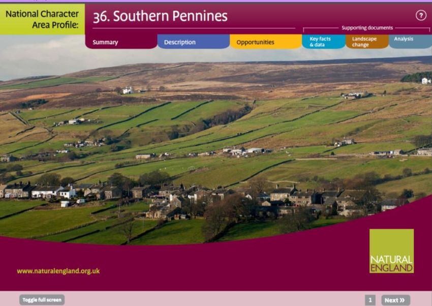
Keeping
                                         Rivers
                                         Cool
Getting ready for climate change by creating riparian shade

                                         Rachel Lenane BSc, MSc, MIEEM
                                         Environment Agency
                                                                  3
                                         23/07/2012 v.3
Foreword

Getting ready for climate change by creating riparian
shade

Purpose: This guidance has been produced to support the creation of shade over rivers using
riparian trees and vegetation (riparian shade). The focus is on maintaining suitable freshwater
habitat for salmon and brown trout (salmonid) populations that we expect to be at risk from the
effects of climate change. It has been written to explain the benefits of riparian shade (sections 1
and 2) and provide consistent advice on creating riparian shade (sections 3-10) to support the
Environment Agency‟s initiative on Keeping Rivers Cool. It has been designed for use by the
Environment Agency „Keeping Rivers Cool‟ pilot catchment officers and „Keeping Rivers Cool‟
leads in external partner organisations. As we gather more information on best practice ways of
creating riparian shade we will add to and develop this guide, making it more widely available to
land owners and other interested organisations in the second year of the project.

How to use this guide: This is designed to be used as a digital guide containing brief
summarised information on creating riparian shade. It contains embedded electronic links to
additional useful information. Because of these electronic links it is easier to use the guidance on a
computer (rather than a print out) in order to go straight to recommended websites.

If you would like to suggest any changes to this document, let someone know that an electronic
link needs updating, or have further information that could be included, please contact Rachel
Lenane.

                                                                                                       4
Contents

1. Introduction ......................................................................................... 7
  1.1 Climate change and river temperature ................................................................................... 7
  1.2 Optimum river temperatures for salmon and brown trout ....................................................... 8
  1.3 Wider ecological benefits of riparian vegetation ..................................................................... 8
2. Site selection and design - targeting planting and fencing .......... 10
  2.1 Factors influencing water temperature ................................................................................. 10
  2.2 Channel orientation .............................................................................................................. 12
  2.3 Tree and shade mapping tools ............................................................................................. 13
  2.3.4 Existing tree cover (LiDAR derived vegetation object maps) ............................................. 14
3. Species selection for tree planting schemes ................................. 15
  3.1 Planting native woodland...................................................................................................... 15
  3.2 Broadleaves not conifers ...................................................................................................... 16
  3.3 Using National Character Area Profiles ................................................................................ 17
  3.4 Creating a diverse vegetation structure ................................................................................ 17
  3.5 Other tree species considerations ........................................................................................ 18
4. Natural regeneration & protecting trees with fencing ................... 19
  4.1 Fencing design considerations ............................................................................................. 20
  4.2 Stock watering ...................................................................................................................... 21
5. Funding available for planting trees................................................ 22
  5.1 The Woodland Trust MOREwoods scheme ......................................................................... 22
  5.2 Funding from local councils .................................................................................................. 22
  5.3 Heritage Lottery Fund ........................................................................................................... 22
  5.4 Grants available for woodland creation in Wales .................................................................. 22
  5.5 Grants available for woodland creation in England .............................................................. 23
6. Maintenance of riparian trees and vegetation ................................ 25
7. Consents and local engagement ..................................................... 26
  7.1 Environment Agency consents ............................................................................................. 26
  7.2 Local Authority consents ...................................................................................................... 26
  7.3 Local engagement ................................................................................................................ 26
  7.4 Access rights ........................................................................................................................ 26
  7.5 Secretary of State approval .................................................................................................. 27

                                                                                                                                             5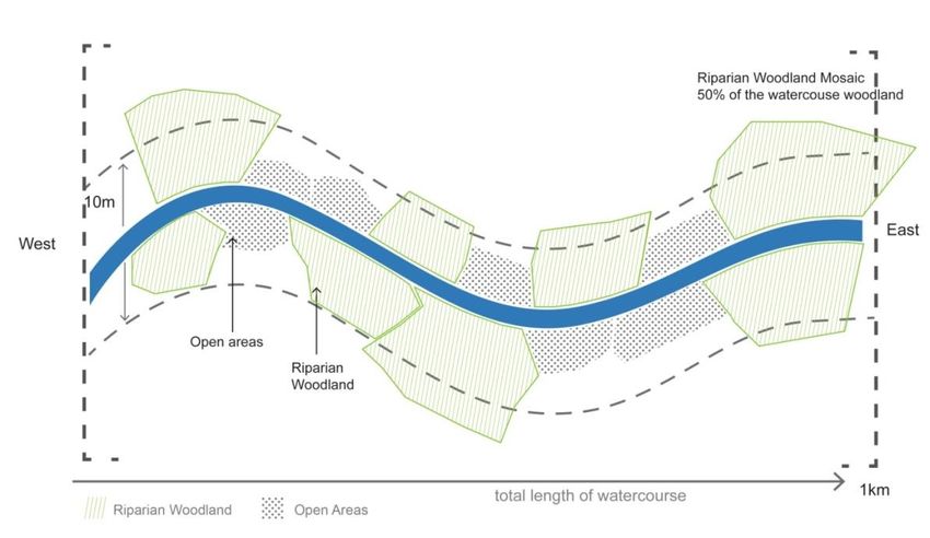
8. Taking flood risk into account ......................................................... 27
9. Other potential constraints on tree planting .................................. 30
  9.1 Avoiding priority habitats and species .................................................................................. 30
  9.2 Invasive non-native species control ...................................................................................... 30
10. Examples of good practice of creating riparian shade ............... 31
  10.1 Wye & Usk Foundation (WUF) - Natural regeneration to create shade and prevent erosion
  on the Upper Afon Clywedog, Ithon Catchment, Wye valley ...................................................... 31
  10.2 Eden Rivers Trust – Creating shade and preventing erosion through planting riparian trees
  on the River Petteril, Eden catchment ........................................................................................ 32
Annex I ................................................................................................... 33
References ............................................................................................. 36

                                                                                                                                 6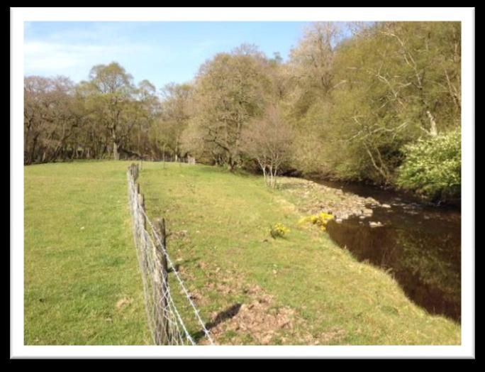
1. Introduction

1.1 Climate change and river temperature

Predicting the future is fraught with uncertainty however, climate experts have tried to capture some of this
uncertainty in the current set of scenarios for the UK in the UKCP09 projections1. The models predict that
average summer air temperatures will warm by between 2°C and 4°C by the 2050s compared to the long-
term 1961-90 average temperature. River temperatures are sensitive to changes in climate and water
temperatures are expected to rise by a similar amount2. It may not seem much but even small changes like
this can have an impact on the health of wildlife living in freshwaters. Brown trout and salmon are
particularly vulnerable to predicted climate change. A rise in water temperature above 22°C for more than
seven consecutive days can be lethal for brown trout3.

The Environment Agency is looking at ways of keeping rivers cool and taking action now to prevent, where
possible, rivers in England and Wales becoming inhospitable for our freshwater wildlife over the next 60-70
years. Trout and salmon populations in England and Wales are already under stress with some rivers
reaching temperatures above the lethal limit for these species during recent hot, dry summers.

Historically natural rivers, streams and their floodplains across the UK were more densely wooded, and
woody debris would have been a common feature in river channels4. Much of this tree cover has been lost
and many rivers now lack shade. Riparian trees and shrubs can help reduce local stream temperatures on
hot summer days. Summer mean and maximum water temperatures are on average 2-3ºC lower in shaded
than in open rivers5. Increasing tree and shrub cover in the riparian zone will also help to provide a natural
source of in stream woody debris. Woody debris is beneficial for many species of plants, invertebrates and
fish6. Leaf litter accumulates against woody debris and is an important food reserve for shredding macro-
invertebrates. Research in the UK showed 147 invertebrates, some rare, were strongly associated with
woody debris7. Otters also use woody debris for “resting” sites. It also has a key role in protecting salmonid
fish through the creation of thermal refugia as water temperature at the stream bed can be significantly
cooler than at the stream surface particularly during periods of low flow when temperatures are likely to be
highest. EA staff should see our internal policy position, „Woody debris in rivers (43_12)8‟, for more
information on this topic.

In the right location natural regeneration, through livestock exclusion and fencing-off lengths of river, is a
good habitat restoration method as the new woodland will closely match existing woodland in proximity to
the site. Natural regeneration also has a good survival rate, so if the site and time frame allows it is also a
cost effective method of woodland creation. Where planting is more appropriate (or a combination of
natural regeneration and planting) a planting design plan should be prepared which takes account of
specific site conditions, appropriate sources for plant stock and includes consideration of future
management.

In certain circumstances other interventions for cooling rivers for example, river restoration, heated effluent
control, modified abstraction regimes and water meadow management may also be beneficial and we will
be exploring these in the future. In the mean time we aim to help create riparian shade where we think it will
have the greatest benefits for river ecology.

1
    Jenkins, G.J., Perry, M.C., and Prior, M.J. (2008)
2
    Webb, B.W. & Nobilis, F. (1997)
3 Elliott, J. M. & Elliott and J. A. (2010)
4
  Peterken, G.F., Hughes, F.M.R. (1995)
5
  Bowler, D.E., et al.(2012) & Caissie, D. (2006)
6
  Braccia, A. & Batzer, D.P. (1999)
7
  Godfrey, A. (2003)
8
  Environment Agency (2012)
                                                                                                                  7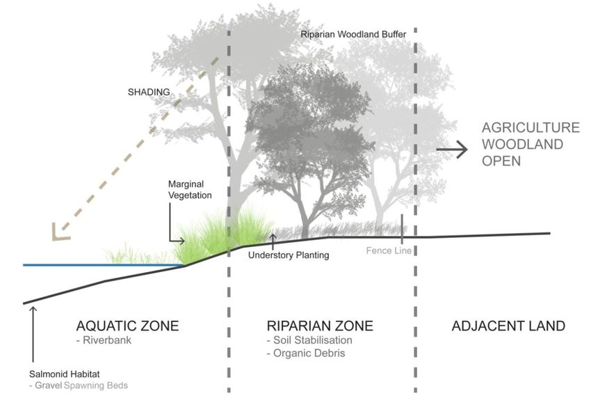
Although there are still some knowledge gaps about the cooling effects of introducing more riparian trees
we can‟t ignore the risks of climate change to river conservation. Creating riparian shade in the right places
can also provide a range of wider ecological benefits. We recognise that it is not a standalone measure to
managing warming in rivers, but it is a low-risk reversible action, providing a range of ecosystem services
and a good start to keeping rivers cool.

1.2 Optimum river temperatures for salmon and brown trout

Water temperature affects all physical, chemical and biological processes in the freshwater environment
and it displays natural diurnal and seasonal variations, dependent on location and climate9. These daily
temperature fluctuations are more pronounced in small streams, particularly if they are not shaded by
riparian vegetation.
In freshwater systems most species have a specific temperature range in which they can live. Salmonids
require temperatures of between 5 and 15°C for normal growth and temperatures above 22°C for more
than seven consecutive days can be lethal for brown trout 10. In smaller fresh water streams in Southern
England, temperatures in excess of 31°C have already been recorded11. These recorded temperatures
highlight the need to take action to try and reduce water temperatures in streams in order to protect trout
and salmon populations and maintain a suitable habitat to support them.

1.3 Wider ecological benefits of riparian vegetation

The influence riparian trees have on the habitat quality of the river is determined by tree species, extent
and structure of the woodland, and the topography of the riparian zone. Organic inputs from the riparian
zone in the form of leaf litter, and insects can account for up to 50% of the energy in a river system. The
many benefits provided by riparian vegetation (

Figure 1) in helping to maintain natural stream functions are shown in Table 1.

Table 1. The functional roles of different vegetation components of the riparian zone and adjacent land
(provided by SKM Enviros).

     Zone                           Location      Component                           Functions

                                                                  Stream bank erosion control, provision of
                                                Tree roots        thermal refugia and shelter from predators,
     Riparian Zone – Aquatic Zone

                                                                  and nutrient uptake.
                                    River
                                    Bank                          Provides shade at stream margins, erosion
                                                Herbaceous        control, sediment retention, nutrient source
                                                Vegetation        (e.g. leaf litter and terrestrial invertebrates),
                                                                  uptake of nutrients and habitat for wildlife.

                                                                  Shade moderates water temperature and
                                                Canopy and        instream productivity, nutrient sources (e.g.
                                    Margins
                                                Trunks of Trees   retained leaf litter, wood and terrestrial
                                    of Rivers                     invertebrates), uptake of nutrients, CWD
                                                and Shrubs
                                                                  creates habitat and cover for wildlife and
                                                                  thermal refugia. Trees and woody debris can

9
  Broadmeadow, S., et al. (2010)
10
   Elliott, J. M. & Elliott and J. A. (2010).
11
   Broadmeadow, S. et al. (2010).
                                                                                                                      8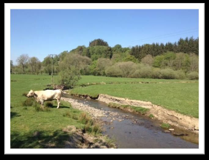
Zone             Location      Component                          Functions

                                                   help to slow flood flows

                                                   Barrier between stream and adjacent land
    Adjacent Land

                    Areas
                                                   use, improves soil structure increasing
                    adjoining   Woodland and
                                                   infiltration and slowing surface run off leading
                    the         shrub and field
                                                   to uptake of nutrients and retention of
                    riparian    layer vegetation
                                                   sediment and provides habitat for wildlife,
                    zone
                                                   particularly otters.

Figure 1. The riparian zone is defined as the area of land adjoining a river channel, including the river bank
but not the wider floodplain. It can provide shade to cool the stream, stabilise stream banks, and act as a
source of nutrients and woody debris (provided by SKM Enviros).

                                                                                                                 9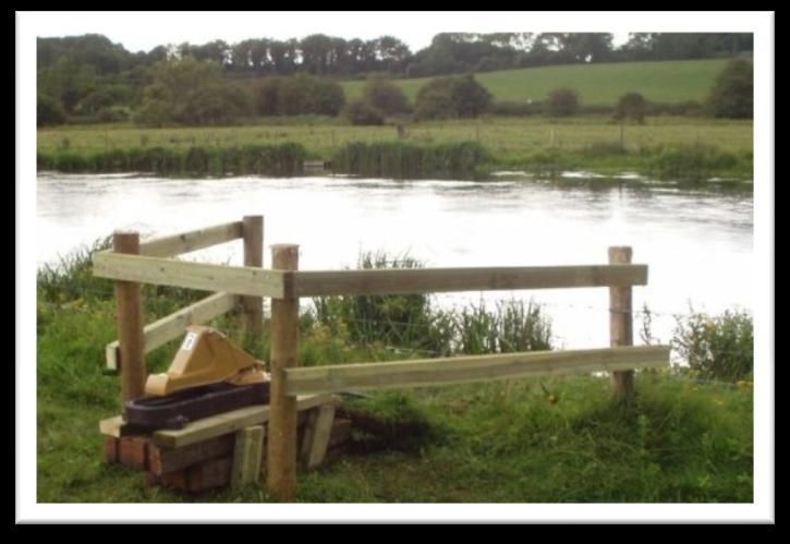
2. Site selection and design - targeting planting and fencing
2.1 Factors influencing water temperature
Figure 2 indicates the complex interplay of some of the dominant factors influencing river water temperature
and shows how the efficacy of riparian shading in cooling stream temperatures reduces downstream.
Planting the banks of the headwater streams is likely to offer the greatest benefits to water temperature
within a river basin12. The graph also indicates the impact that tributary inflows can have on stream
temperature and may indicate that all tributaries to a point should be considered for tree planting to
maximise the benefits. These upstream/ downstream influences obviously depend on the size of
catchments and channels and no evidence has yet come to light about how to quantify how far such
impacts extend downstream in UK catchments.
Discharge
High
Impact on stream temperature
Groundwater
Mediu
m
Tributaries
Low
Riparian shade
Upstream Downstream
Figure 2. Conceptual impact of riparian shading, tributary influences and discharge on stream temperature
from catchment headwaters to outlets (based on Poole & Berman, 2001).
The focus of riparian planting or fencing to reduce instream temperatures should be in uplands or
head waters on smaller low order streams (see Error! Reference source not found.). Stream orientation
hould also be considered in the design of tree planting or fencing schemes to optimise shading
over the stream channel. In addition to the creation of riparian shade in the streams of the upper
catchment, there may be benefits of planting riparian trees further downstream to create thermal
refuges for fish.
Specific local issues will influence site selection for tree planting or fencing. An important consideration will
be the availability of land and support of landowners. Other catchment objectives such as the reduction of
flood risk and the impacts of diffuse pollution13 will influence choice of species, planting design and site
selection.
The width of the riparian zone that needs to be planted to provide optimum shade is not yet clear. To gain
more evidence it would beneficial to plant a range of widths within the „Keeping Rivers Cool‟ pilot
catchments. When considering planting or fencing to create riparian shade, we initially recommend:
Selecting headwaters (low order streams)
Planting and fencing on streams of less than 5m width
Planting belts of riparian trees between 2 – 5m wide (although greater widths than this are
preferable, with land owner support, for other measures such as reducing diffuse pollution).
Fencing should be on both banks for effective stock proofing.
12
Correll, D.L. (2005)
13
Forestry Commission (2011). p.46 „Water quality and buffer areas‟.
10 Shading 50% of the water surface with dappled shade14 as shown in Figure 3, unless working on
chalkstreams where Natural England have recommended shading of about 30% where in-channel
macrophytes need to be considered.
15
Box 1. How many trees to plant
How many trees to plant?
The number of plants required for each area will depend on the design used. Once the areas to be
planted and the species have been decided, the number of plants for each species can be calculated.
The Woodland Trust provides the following guidance on planting per hectare:
“High stocking rates can be used to speed up canopy closure and gain „control‟ of a site more rapidly,
especially on weedy sites to keep maintenance costs down, or where rabbits may cause high losses.
One to two year-old trees (30–60cm) planted at 2–2.5 metre centre spacing is the most common
„formula‟ and provides reasonably rapid canopy closure. Older, taller trees will cost disproportionately
more, grow more slowly when first transplanted and have a lower survival rate.”
• Planted every 3 metre centres – 1,111 trees per hectare
• Planted every 2.5 metres centres– 1,600 trees per hectare
• Planted every 2 metre centres – 2,500 trees per hectare
Planting is best undertaken between October and March when trees are fully dormant and most
tolerant to stress caused by lifting, handing, storage and transporting.
For information about different British tree species please refer to: http://www.british-
trees.com/introduction
British Trust Conservation Volunteers have a useful practical guide on how to plant and manage
trees: „Trees and Aftercare: a practical handbook’: www.btcv.org/handbooks
The Woodland Trust also have a plethora of practical tree planting information. Advice is available
here including species information, tree planting costs, funding advice, design considerations and a
picture guide to planting trees.
14
Broadmeadow, S. & Nisbet, T. (2002)T (p.6 Summary of findings)
15
Woodland Trust (2010)
11Figure 3. Riparian planting should create a mosaic of tree cover producing dappled shade that covers around
50% of a reach (provided by SKM Enviros).
Box 2. Strahler Stream Classification
Strahler Stream Classification
The Strahler Stream Classification is used to define stream order based on a hierarchy of tributaries
(Figure 4) Streams are classed in orders, 1, 2 and 3. Headwaters are order 1, being the smallest and
very start of a watercourse. When two 1st order streams come together they form a 2nd order stream,
this process continues, as the size of the watercourse grows. A 2nd order must join another 2nd order
to make a 3rd order stream.
Figure 4. Strahler Stream Classification
2.2 Channel orientation
The orientation of the channel is an important consideration as it will determine the extent and duration of
shade cast over the water‟s surface during the day. On a watercourse orientated east-west light will reach
the river bank for a large proportion of the day unless shaded by woodland situated on the southern bank.
Rivers with a north-south orientation will have more restricted light levels, except for the middle of the day
12when they will receive little protection from woodland on either bank, particularly if the river channel is wide
(Figure 5).
East – West Orientation North – South Orientation
Figure 5. Direction of sun travel and corresponding shade cast (provided by SKM Enviros).
2.3 Tree and shade mapping tools
We have developed two mapping tools to help identify the right places to plant trees to create more shade.
One shows you where there are gaps in tree cover and the other helps identify the degree of existing
shading. Both tools are derived from LIDAR (Light Detection And Ranging) data for England and Wales
collected by the Environment Agency. We provide accurate maps of riparian tree distribution, indicating
presence and absence of riparian vegetation over 2.5m (this is how we defined existing trees), and shade
maps, indicating where rivers are most and least shaded within a catchment. These maps are intended as
guidelines only and decisions should be supported by local site information and survey.
2.3.1 Catchment shade maps
For a limited number of catchments we have developed „shade maps‟ (Figure 6) using models showing
average incoming solar radiation within catchments, where there is LiDAR data (there are some gaps
across the country). The measure of incoming solar radiation indicates the likely amount of shade created
by the landscape e.g. hill and valley effects as well as shading caused by existing vegetation. These shade
maps can be used to support the identification of key areas to target to increase riparian shade. The shade
maps are intended as guidelines only and decisions made using these should be supported by local site
information or survey.
2.3.3 What catchments are shade maps are available for?
Shade maps involve a lot of computer processing time. We have only produced a limited number for the
River Basin management pilot catchments and „Keeping Rivers Cool‟ pilot catchments, as well as a few for
catchments that managers have contacted us about because they are planning tree planting projects. At
the time of writing shade maps are available for: Wye, Rivers Test & Itchen, Hampshire Avon, Derbyshire
Derwent, Tyne, Frome (Dorset), Cherwell (West Thames), Dove (Midlands), Ribble, Shropshire Middle
Severn, Kennet & Pang, Wey, Adur & Ouse, River Don, Wear, Tone, Ecclesbourne, River Leam, Welland
and Irwell.
13Figure 6. Example of a shade map pdf
Shade map pdfs are licensed as EA Opendata. For more information on shade maps, or access to the
data, please contact Alastair Duncan.
2.3.4 Existing tree cover (LiDAR derived vegetation object maps)
Data about the presence of existing trees are available in two formats. One is easy to view and can be
used without any special software as Georeferenced JPEGs (Figure 7), which are a visual representation.
The second is Binary Grid format which contains the vegetation objects >2.5m (trees) and can be used with
Geographic Information Systems (GIS). Both data formats are available under license as special data.
They are both chargeable for non-commercial & commercial use, but the license also allows exemption
from the charges where the organisation requesting the data is a co-deliverer of the „Keeping Rivers Cool
Project16‟ or has a partnership agreement with the EA. The data are presence/absence so do not give
actual heights of individual trees but just note them if they are greater than 2.5m high.
Figure 7. Part of JPEG image of LiDAR derived vegetation object map showing vegetation over 2.5m
For more information on shade maps, or access to the data, please contact Alastair Duncan.
16
Agreements are currently in development and likely to include Rivers Trusts, The Woodland Trust, Forest
Research, Forestry Commission and Natural England.
142.3.5 Rivers Trust catchment mapping portal
Using various partner organisation data sets in GIS, it is possible to overlay various catchment data and
identify where the most benefits from planting and fencing can be obtained. The Rivers Trust have
developed a catchment mapping portal which allows non-GIS users to do this. For more information and a
link to the portal visit: http://www.theriverstrust.org/catchment_mapping/index.html
The Ribble Rivers Trust is also working on developing a GIS based system for prioritising sites for planting
and fencing.
3. Species selection for tree planting schemes
3.1 Planting native woodland
The establishment of native woodland within riparian zones presents an opportunity to enhance the
biodiversity of the area. Native tree species support a greater diversity and abundance of terrestrial
invertebrates and provide high quality of leaf litter, which is beneficial to the aquatic zone17. There are
several issues to consider when selecting planting material including the species, provenance and origin of
seed stock. These are discussed below in Boxes 2-4. Water use by trees might also be a consideration in
areas which may suffer drought.
18
Box 2. British Native Trees
British Native Trees
British native trees are those that re-colonised the British Isles naturally, without human intervention,
after the retreat of the last Ice Age some 10,000 years ago. Over many generations populations of
these species have adapted to specific local conditions (soil type, climate etc) resulting in the genetic
make-up of woodland of local provenance.
The Environment Agency only recommends planting of British Native trees.
Box 3. British Native Provenance
British Native Provenance
A tree of British Native Provenance is one whose seed was collected from a known location in the wild
within Britain. Its Forestry Commission Seed Zone should be given (see information in Box 4.).
17
Broadmeadow, S. & Nisbet, T. (2002)
18
NEAS (2007)
1519
Box 4. Local Provenance
Local Provenance
A tree of local provenance is one whose seed was collected from within the same Forestry
Commission Seed Zone as it is to be planted.
Ideally a plant‟s parents should come from that catchment or at least the general area. These plants
will be better adapted to the local environment and contain characteristics that can add to the local
distinctiveness of an area.
The Environment Agency encourages the use of local provenance stock in its schemes. There are
certain areas where local provenance stock must always be used, for example within wooded Sites of
Special Scientific Interest (SSSIs), Ancient Woodland and historic landscapes. For these sites we do
not recommend planting, natural regeneration is the better option.
Using local provenance stock can require advance planning. For information about British flora
suppliers visit the Flora Locale website. Flora Locale is an independent charity promoting the
conservation and enhancement of native wild plant populations and communities.
The Forestry Commission has developed a system to help the identification of, and trade in, locally
sourced stock for planting native trees and shrubs. This is a map of local seed zones (based on major
geoclimatic influences and taking account of geological and landform boundaries); and guidance on its
use. It also includes a voluntary scheme to allow seeds and plants to be identified and monitored in a
consistent way.
For more information about Using local stock for planting native trees and shrubs please refer to
Forestry Commission practice note 008.
3.2 Broadleaves not conifers
The optimum tree type to plant to provide shade on rivers are broadleaves with lighter foliage for
example birch, willow, rowan, ash, hazel, aspen and bird cherry20. These will provide dappled shade
for rivers, with reduced water interception. Species with denser crowns of foliage such as oak and
beech can be interspersed with these21.
We do not support the planting of conifer in floodplains or adjacent to rivers22 for several reasons:
Extensive conifer planting in river catchments with poorly buffered soils can indirectly lead to
acidification of rivers23.
Coniferous woodland, should not be planted within 20m of the stream bank due to the heavy shade
cast by the canopy all year round which can be detrimental to riparian habitat quality due to the
restricted growth of the understory leading to bare stream banks and high rates of sedimentation24
Water use by conifers is generally higher than by broadleaves. As conifers retain their leaves
throughout the year they intercept more rain which is lost via evaporation rather than drainage,
preventing it from reaching the ground25 for use by other flora and running off into rivers.
19
Herbert, R. Samuel, S. & Patterson, G. (1999)
20 Forestry Commission (2003)
21
Nisbet, T. (2005)
22
NEAS (2007)
23 Nisbet, T., et al. (2011)
24
Broadmeadow, S. and Nisbet, T.R. (2004)
25
Nisbet (2005), & Calder, I.R., et al. (2008)
163.3 Using National Character Area Profiles
The trees planted on riparian banks should reflect the geographical location and character of the area.
England has been divided into National Character Areas (NCAs) by Natural England (Figure 8) to promote
conservation planning at a landscape scale. NCA profiles will be published in September 2012 and will
include a section on the trees and woodland which provides information about local species. This should be
used to inform planting plans in terms of choice of species and type of planting.
Figure 8. Front cover of Natural England’s National Character Area Profile for the Southern Pennines
3.4 Creating a diverse vegetation structure
The aim when designing new lengths of riparian trees and shrubs is to create an intricate structural mosaic
of habitat producing dappled shade on the water course. As well as helping to keep the river cool, greater
diversity of riparian vegetation, incorporating a mixed age structure, mixed species and vegetation heights
can increase the conservation value for invertebrates, birds and other organisms26.
Five key structural habitats can be used to achieve this mosaic effect27:
1. Open ground, particularly in the marginal aquatic zone;
2. Occasional isolated trees that will ultimately achieve a grand size
3. Open glades within the woodland28
4. Patches of scrub; and
5. Closed canopy native broadleaf woodland.
A management plan should be prepared to ensure that in time a mix of tree and shrub ages is achieved.
Initial planting should include quick growing short lived species amongst slower growing species that will
hopefully become veteran landscape trees eventually as mature trees are especially important in providing
wood and woody debris to the stream.‟i When developing a planting plan consider the desired height of
riparian trees in order to provide enough shade for your stream width (Figure 9). For information on tree
heights at different ages for different broadleaf native species see graphs and tables in Annex I.
Your local Woodland Trust contact may be able to help you develop a planting plan.
26
Broadmeadow, S. & Nisbet, T. (2004)
27
Forestry Commission (2003)
28
if a woodland, rather than a riparian belt is being created
17Figure 9. Vegetation structure and height can have a direct effect on the level of shade cast over the water’s
surface and thus on water temperature (not to scale, provided by SKM Enviros). (also see graphs and tables
in Annex I)
3.5 Other tree species considerations
Tree Disease
Alder is considered a „riparian specialist‟ and is useful at stabilising riverbanks; however it is suggested that
in areas of acid sensitivity „the use of alder should be limited‟. The UK Forestry Standard „Forests and
Water Guidelines 2011‟ recommend that the planting of alder should be limited to less than 10% of the area
within riparian zones of water bodies failing or at risk of failing good status due to acidification. More
information is available from the Forestry Commission here.
Information on other plant pests and diseases can also be found on the Forestry Commission website here.
Water use by trees
Predicted drier summers will create a higher water demand and increased pressure on water resources. As
water uptake and use can vary between different broadleaf trees, the impact of trees on the water regime of
adjacent land should be considered particularly at sites draining on to wetland habitats. Riparian woodland
planting is unlikely to have a significantly detrimental impact on the general water resource although it may
be unacceptable to other stakeholders in catchments which have recently been affected by drought.
More research is needed to quantify the water use of a wide range of native woodland species. It is known
that Willow and Poplar can sustain high transpiration rates of over 500 mm yr-1 in wet soil conditions29
which is higher than other broadleaf species. It should be noted that tree shading may in some
circumstances reduce evaporative losses from streams and this is part of the reason why the interactions
between riparian trees and water use is not straight forward. For more information on this topic see „Water
use by trees‟. A Forestry Commission Information Note 065
29
Hall, R.L. et al.(1996)
184. Natural regeneration & protecting trees with fencing
An important element in establishing new riparian trees is protection by fencing from browsing and
trampling domestic livestock and adjacent land uses, as well as delineating the area to be managed
appropriately. Most, if not all areas of tree planting will require stock proof fencing. Other benefits of fencing
include the reduction of „poaching‟ by animal hooves, which can cause bank erosion and reduction of
stream pollution by animal waste (Figure 10). Fencing should be on both banks to prevent stock from
crossing the stream to browse on the adjacent side (Figure 11.)
Figure 10. Example of cattle poaching, over grazing and bank erosion on an un-fenced tributary of the River
Ithon, Wye (photo by Rachel Lenane).
Figure 11. Example of riparian banks with only one bank fenced, allowing access to grazing livestock on both
sides, tributary of the Tyne (photo by Rachel Lenane).
There are different views as to the merits of fencing to allow natural regeneration to take place, versus
actively planting trees along rivers. In upland areas where there is very little opportunity for native flora to
propagate from local seed sources the natural regeneration approach may not be successful. Alternatively,
where there are local seed sources the approach may generate hardy plants of local provenance, well
adapted to local conditions. Natural regeneration can be a very cost effective measure, if location and time
frame permit, but there is far less control over the structure and design of the local site. When opting for
natural selection invasion of non-native species like sycamore, Italian alder or Japanese knotweed must be
considered.
Careful analysis of advantages and disadvantages of actively planting trees against promoting natural
regeneration is needed in the early design stages of a project. Site specific characteristics will play an
important part in the outcome.
The merits of the different approaches will be something that will be explored through the „Keeping Rivers
Cool‟ pilot catchments.
194.1 Fencing design considerations
The Conservation Volunteers (formerly known as „British Trust of Conservation Volunteers‟) has published
an excellent handbook on fencing: BTCV – Agate, E., 2001. Fencing a practical handbook. BTCV
Enterprise Ltd. Which can be purchased from Amazon or through the EA‟s online book purchase system.
Key fencing recommendations:
Tree tubes are recommended to provide protection to the young saplings especially where rabbit
or deer grazing is evident locally, at least initially until the newly planted stock is established.
Rabbit spiral guards may be more cost effective than tree shelters and require less maintenance.
In exposed conditions tree shelters can be readily blown over, and if not spotted and rectified
quickly, cause abnormal growth of the emerging tree.
Fencing should be designed to be robust and able to accommodate the full extent of the
watercourse through the year to take account of the patterns of flooding of marginal areas year
round, as this will be a key influence on fencing design and layout.
Ideally the line of the fence should be positioned as far from the watercourse as possible, which
reduces the risk of bank erosion caused by flooding from undermining the fence line.
In flood prone areas, line and wire (rather than netting) is recommended for riparian fencing as it
reduces the chances of flood debris getting caught. Running fencing parallel to the direction of
the watercourse helps to reduce flood damage, and minimises the accumulation of debris.
Where it is impossible to avoid placing fences across the direction of water-flow, it is important to
strengthen key strainers and posts, bracing as necessary. Separating the fence into more and
less vulnerable sections, will avoid losing tension in long stretches of fencing. One technique is to
build in weak links which will give way under moderate pressure, prevent excessive strain on the
overall fence line. These „Sacrificial‟ weaker sections are designed to minimise the cost of re-
building flood damaged fencing, as it is cheaper to re-wire rather than completely re-fence.
The fence line should have frequent access points, for maintenance.
In situations where livestock require access to the watercourse it is important this is done in a
controlled way. In some cases provision of watering troughs or field pumps may provide a
solution, thereby reducing livestock access. Where crossing points are needed water-gates may
be necessary.
„When fencing riparian schemes, it is important to consider the need for gates and deer-jumps to
ease the removal of stray livestock and for maintenance, kissing-gates or stiles on footpaths for
visitor access, and the possible need for badger gates.‟ Vehicles may also require access, it is
preferably for any ford access there is a hard base.
„It is also essential to check fences and water-gates regularly, and especially after floods‟
It is important to be aware of local species considerations, for example, whether the fencing
needs to include bird strike markers to deter Black Grouse from becoming entangled in the
fencing (e.g. in the Ribble catchment).
204.2 Stock watering
Where livestock are prevented from accessing water from adjacent streams new solutions will need to
be provided. Pasture pumps can be low maintenance solutions to providing stock watering in remote
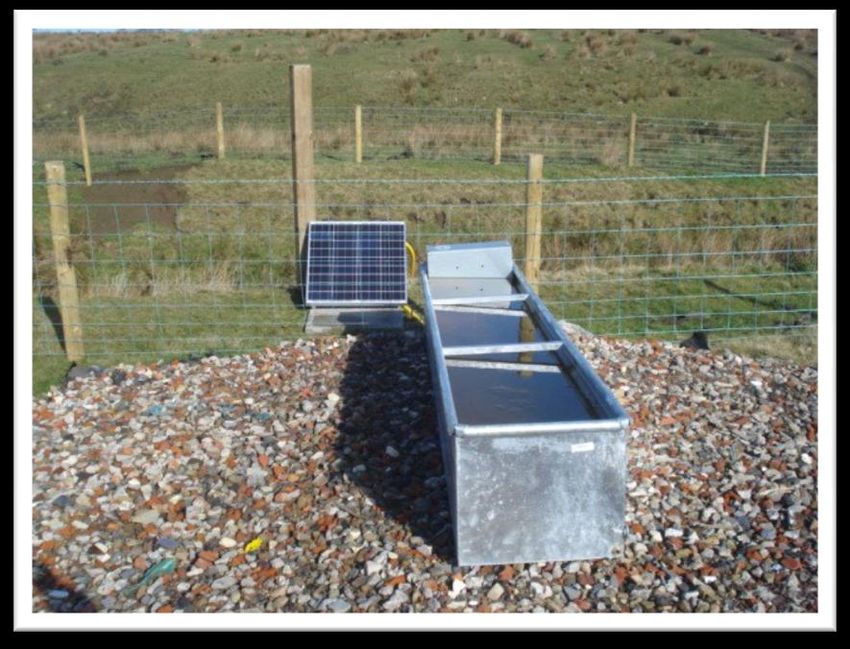
locations where streams have been fenced off (Figure 12, Figure 13, Figure 14). They are portable and
can be placed up to 50 metres away from the river. More information on these can be found on the
Defra website.
Figure 12. Sheep operated pasture pump providing water from a fenced off tributary of the River Ithon in the
Wye (photo by Rachel Lenane)
Figure 13. A cattle operated pasture pump for more details look on the Defra website
Figure 14. Solar powered stock watering trough in the Ribble catchment (Photo provided by Jack Spees,
Ribble Rivers Trust Director)
215. Funding available for planting trees
Various schemes and sources of funding are available to assist landowners and communities plant trees or
create woodland. The Royal Forestry Society has a list of over 50 grants and funding schemes available for
woodland creation and management available here.
Below is a quick guide to the current funding schemes that you are most likely to find useful for creating
new small native riparian woodlands. None of the schemes below explicitly provide funding for planting less
than a hectare. However, exceptions can be made, so it may be worth contacting the relevant organisation
to discuss your planting scheme further.
The Woodland Trust woodland creation team can provide advice on Forestry Commission funding. Their
details can be found by clicking here. Some examples of available funding are as follows:
5.1 The Woodland Trust MOREwoods scheme
If the grants summarised below are not appropriate for your planting scheme, the Woodland Trust (WT)
may be able to help. The „MOREwoods‟ scheme run by the Trust offers support and guidance in the first
instance to help you with your scheme but can also provide small grants of materials in appropriate
circumstances. The scheme is ideal for small-scale, scattered, low density planting on sites of 0.5ha and
above. Riparian planting or planting in diffuse or narrow blocks (such as shelterbelts, riparian schemes or
maximising field corners). Where appropriate landowners receive help with materials (trees / stakes / tubes)
– whilst the landowner is still required to pay towards the materials they receive them at a 60% discount to
their actual cost; £1,000 worth of materials costs the landowner only £400.
WT officers provide help with species choices and planting design. When the landowner is happy with the
proposal WT will arrange to deliver the trees and associated materials. The WT can also arrange planting
through a contractor, if desired, with the landowner being asked to provide 70% of the total costs.
It is worth noting that unlike the Forestry Commission England and Welsh Glastir grant schemes, planting
under MOREwoods may affect your Single Farm Payment. If you are claiming this and wish to continue to
claim it please check implications prior to planting.
Further information on the MOREwoods scheme can be found by clicking here.
5.2 Funding from local councils
Some local councils offer support for small scale woodland creation schemes. This can be anything from 25
free trees to grants of up to £500. In the first instance contact your local authority to find out what is
available in your area.
5.3 Heritage Lottery Fund
We will be encouraging partners in the „Keeping Rivers Cool‟ project to apply for Heritage Lottery Funding
from 2014-2016. For information on how to make an application please visit the HLF web pages here.
Please also contact Rachel Lenane to let her know that you are considering this option so she can
coordinate the applications under the „Keeping Rivers Cool‟ banner.
5.4 Grants available for woodland creation in Wales
Welsh Government, Glastir
From 2012 Glastir is replacing existing agri-environment schemes. It has a „Woodlands Element‟ designed
to support land managers who wish to create new woodland and/or manage existing woodlands.
Forestry Commission Wales, Woodland Creation Grant
The Glastir Woodland Creation Grant (WCG) is administered by Forestry Commission Wales:
22 For all landowners across Wales with more than 0.25 hectares of land
On land designated by Forestry Commission Wales and conservation bodies in Wales as suitable
for new planting.
Where there is no conflict with other agri-environmental schemes.
The grant includes an allowance for fencing including gates and stiles
Comprehensive information on the grant, including a list of Glastir project officers to contact and a helpful
FAQ section, is available here
5.5 Grants available for woodland creation in England
Funding for woodland creation is normally supported through the Forestry Commission‟s English Woodland
Grant Scheme, though there are some instances where Natural England‟s Environmental Stewardship
Scheme is more appropriate, for example where woodlands are grazed by livestock, or for woodlands on
common land. If neither of these schemes are suitable the Woodland Trust‟s „MOREwoods‟ scheme,
mentioned above, may also be able to provide funding.
Forestry Commission’s English Woodland Grant Scheme
The Forestry Commission‟s (FC) English Woodland Grant Scheme (EWGS) offers a suite of 6 grants to
help create and enhance woodlands for environmental and social. The Woodland Creation Grant (WCG) is
the FC‟s main grant contributing to the costs of establishing new woodland. A summary is provided below,
for more comprehensive information from the FC please click here.
Forestry Commission’s Woodland Creation Grant (WCG)
The aim of this grant is to create woodlands that generate public benefits. Particular priorities are new
woodlands:
For wildlife, particularly where they can act as protective buffers and link important woodland
habitats or other associated natural areas
That reduce flood risk, improve water quality and prevent soil erosion;
That are resilient and can adapt to climate change
Near to where people live, particularly within the urban fringe and that provide access and
recreation
To enhance the landscape and restore former industrial land
To create productive woodlands and wood products that support the rural economy and capture
carbon
Application for WCGs should normally be for planting areas of no less than 0.25ha and on average, no
narrower than 30m with a minimum width of 15m. This may rule out a lot of planting proposals to create
riparian shade.
If you are considering planting trees with other objectives, such as decreasing flood risk and/ or reducing
diffuse pollution the FC provide „Additional Contributions‟ designed to support the creation of appropriately
targeted and designed new woodland. To be eligible for additional contributions the new woodland must
comply with specific design principles outlined in these guidelines.
Natural England’s Environmental Stewardship Scheme (England)
The Environmental Stewardship scheme is administered by Natural England under two headline categories
Entry Level Stewardship (ELS) and Higher Level Stewardship (HLS). It provides funding to farmers and
other land managers, who deliver effective environmental management on their land, including woodland.
See Box 5 for more information.
23Box 5. Information on NE’s Environmental Stewardship Scheme - from information in Forestry Commission England
note, ‘Funding for Farm Woodlands in England’. Grants and Regulations National Team. Version 3.0 Jan 2011 and
‘Look after your land with Environmental Stewardship (NE124).
Entry Level Stewardship (ELS)
Acceptance into Entry Level Stewardship (ELS) is determined by a „points per hectare‟
calculation across an entire farm. On achieving a points target, meeting the scheme conditions
and agreeing to deliver the options chosen, the farm owner will automatically receive funding.
£30 /ha /yr is available for eligible woodland on a points basis e.g. a 100ha holding would need
to achieve 3000 points. The woodland on a holding does not need to be included. An example
option is “maintenance of a stock-proof woodland boundary” – to prevent livestock grazing the
woodland and causing environmental damage @ 4 points per 100 m of boundary.
Points are earned for the range of environmental management options agreed to. There are
over 65 management options to choose from. For the comprehensive list of options please
refer to the „Environmental Stewardship handbook, third edition (NE226)‟, Section 3. For
„Keeping Rivers Cool - creating riparian shade‟, the most relevant ELS options may be in
sections C „Options for trees and woodland‟, E; „Options for buffer strips‟, and J, „Options to
protect soil and water‟. For more information, please visit the Natural England website.
Higher Level Stewardship (HLS)
HLS is a targeted and competitive scheme that is only available to farmers and land managers
in 110 areas across England with particular high priority features on their holding. Support for
woodlands is based on a set of targeting maps where Natural England are seeking the most
environmental benefits from HLS agreements for wildlife, landscape, the historic environment
and resource protection. A Farm Environment Plan is first produced to identify the special
environmental features and their condition. HLS can pay for capital work and annual
payments, with supplements also available. For example, woodland creation may include
capital payment for tree planting and protection work; annual payment for income forgone and
tree maintenance; supplementary payment if public access is provided.
246. Maintenance of riparian trees and vegetation
Useful available guides on best practice ways of managing riparian trees and vegetation include:
SEPA‟s: ‘Engineering in the Water Environment Good Practice guide: Riparian Vegetation
Management, Second edition, June 2009’
Forestry Commission‟s: „The management of semi-natural woodlands: 8. Wet woodlands (2003).
British Trust Conservation Volunteers (Now „The Conservation Volunteers‟) have a useful practical
guide on how to plant and manage trees: „Trees and Aftercare: a practical handbook’ (which can be
bought online, or through the Environment Agency online book purchasing system).
In nearly every case the Environment Agency or other partner will not own the land where tree planting is to
take place. Where the land is not owned by the person or group wishing to carry out works3 landowner
consent and a long-term commitment to maintenance should be obtained before the planting scheme
starts. On most riparian planting schemes it would be beneficial to have at least a 3-5 year maintenance
programme where landscape contractors maintain and manage all planting. After this the landowner should
assume ownership and responsibility for the planting and maintenance of fencing where appropriate. It is
important that the land owner is entirely involved when the tree planting or fencing plans are being
developed and aware of the long term nature of the project.
The contractor should be responsible for all horticultural operations including weed control, for the 3-5
years after planting. The landscape contractor should also remove any planting sundries (spiral shelters,
mulch mats, stakes etc) at the end of the maintenance period.
The EA, Rivers Trust, Woodland Trust or other lead partner should provide landowners with a management
plan so they understand how to manage the trees and fencing.
257. Consents and local engagement
If you are working with an Area Environment Agency Officer they will be able to help you through
the process of gaining consent for riparian planting and fencing. This may involve contacting local
EA Flood Defence Consents Officers, in Area Partnership & Strategic Overview (PSO) teams to
check if new riparian planting is suitable in your area.
7.1 Environment Agency consents
Before planting trees, or erecting fences ask your local EA catchment lead to consult EA Area Asset
Performance teams. They need to be aware of your plans and will advise on avoiding emergency and
maintenance access routes. Early communication will prevent any conflicts of interest arising.
The EA may require Flood Defence Consent for planting within 7 to 16m of main rivers (a main river is a
watercourse marked as such on a main river map)30. This is known as the byelaw strip and different widths
apply to different regions; check with the local office by speaking to the Partnership and Strategic Overview
team. The distance begins at the top of the riverbank, or where there is a flood defence structure, like a wall
or embankment, then it is from the landward edge of that feature.
The Environment Agency may also want to consent for any planting within a designated flood storage area
and within the 1 in 100 year floodplain. As byelaws vary between regions you need to liaise with the
Partnership and Strategic Overview team to see if this is required.
Herbicide treatment adjacent to watercourses will require Herbicide Application consent.
7.2 Local Authority consents
Lead Local Flood Authorities are now responsible for flood defence consents on ordinary watercourses. An
ordinary watercourse is every river, stream, ditch, drain, cut, dyke, sluice, sewer (other than a public sewer)
and passage through which water flows and which does not form part of a main river. Consent is not
required for planting trees on the banks or ordinary watercourses, however, the works should be discussed
with the Lead Local Flood Authority.
7.3 Local engagement
It is important to consult the right interest groups when starting projects which have the potential to alter the
way the landscape looks or riverside access.
If you are considering planting or fencing within an Area of Outstanding Natural Beauty (AONB), it will be
important to consult with the local AONB partnership. It is also good practice to consult with the local
planning authority landscape and/or tree officer.
It will also be important to engage local interest groups early on in the decision making process, these will
include Parish/Community Councils, local angling and rambling groups. The local Area Environment
Agency Officer should be in a good position to know who to contact.
7.4 Access rights
Please bear in mind that the riparian zone is also accessed by other groups from time to time and much
access is by right or by prior legal agreement. As such tree planting and fencing schemes, however
inherently valuable and important they may be, need to accommodate other users. Commonly footpaths or
bridleways will follow sections of water courses. Angling groups may have access. Grazing and watering
rights for stock may affect fence locations. Access for draining and maintenance or overhead / underground
cables and pipes is also often a feature.
30
Main rivers in England are designated by Defra, in Wales they are designated by Welsh Government.
26Where appropriate, ensure that footpaths/rights of way are inclusive and accessible for all by considering
the “Access for All Design Guidance”. This guidance will shortly be available on the Environment Agency
internet pages.
7.5 Secretary of State approval
It would be advisable to avoid proposing planting or fencing on common land as Secretary of State
approval is required for planting or fencing on common land by owners or commoners. The person wishing
to build the fence must advertise the application in a local paper, and the Secretary of State must allow 28
days for members of the public to make representations.
8. Taking flood risk into account
The Information below is taken from the Environment Agency (2012) „Trees near Rivers‟ Quick Guide.
Strategically placed woodlands, trees and shrubs in floodplains can reduce flood risk, by slowing down soil
erosion and holding back flood flows. However, when considering planting trees near rivers EA must
ensure they do not increase the risk of flooding to property; and prevent watercourses and flood defences
from being maintained.
The EA encourages a risk-based approach when considering riverside planting, with a greater level of
consideration needed in higher flood risk locations (see Box 5).
Box 5. Taking flood risk into consideration when planting riparian trees31
Planting individual or small groups (4 to 25 ) of trees and shrubs within the byelaw strip will
generally be acceptable as long as they do not:
1. Obstruct maintenance access,
2. Significantly interfere with flood flows in critical channels, or reduce the capacity
of flood storage areas,
3. Sit within the normal river channel,
4. Affect the approach to bridges, flood span openings or other control structures.
If planted at 2 metre centres this would occupy an area between 4m2 and 100m2. However,
this is not a strict definition and each case should be looked at on its merits. The scale of
the proposal in relation to the overall floodplain is the key consideration.
Follow the flow chart below to help you decide whether to plant trees or not:
31
NEAS (2007)
27You can also read