LSTM-TrajGAN: A Deep Learning Approach to Trajectory Privacy Protection
←
→
Page content transcription
If your browser does not render page correctly, please read the page content below
LSTM-TrajGAN: A Deep Learning Approach to
Trajectory Privacy Protection
Jinmeng Rao
GeoDS Lab, Department of Geography, University of Wisconsin-Madison, WI, USA
Song Gao
GeoDS Lab, Department of Geography, University of Wisconsin-Madison, WI, USA
Yuhao Kang
GeoDS Lab, Department of Geography, University of Wisconsin-Madison, WI, USA
Qunying Huang
Department of Geography, University of Wisconsin-Madison, WI, USA

      Abstract
The prevalence of location-based services contributes to the explosive growth of individual-level
trajectory data and raises public concerns about privacy issues. In this research, we propose a
novel LSTM-TrajGAN approach, which is an end-to-end deep learning model to generate privacy-
preserving synthetic trajectory data for data sharing and publication. We design a loss metric
function TrajLoss to measure the trajectory similarity losses for model training and optimization.
The model is evaluated on the trajectory-user-linking task on a real-world semantic trajectory dataset.
Compared with other common geomasking methods, our model can better prevent users from being
re-identified, and it also preserves essential spatial, temporal, and thematic characteristics of the
real trajectory data. The model better balances the effectiveness of trajectory privacy protection
and the utility for spatial and temporal analyses, which offers new insights into the GeoAI-powered
privacy protection.

2012 ACM Subject Classification Security and privacy → Privacy protections; Computing
methodologies → Artificial intelligence

Keywords and phrases GeoAI, Deep Learning, Trajectory Privacy, Generative Adversarial Networks

Digital Object Identifier 10.4230/LIPIcs.GIScience.2021.I.12

Funding Support for this research was provided by the University of Wisconsin - Madison Office of
the Vice Chancellor for Research and Graduate Education with funding from the Wisconsin Alumni
Research Foundation.

 1      Introduction
The increasing location-based services (LBS) have generated large-scale individual-level
trajectory data (i.e., a sequence of locations with attributes) through mobile phones, wearable
sensors, GPS devices, and geotagged social media [19]. Such trajectory big data provide
new opportunities to study human mobility patterns and human-environment interactions
[11], disaster responses [12, 27] and public health issues [17, 25]. It also introduces grand
challenges regarding the protection of geoprivacy and broader behavioral, social, ethical, legal
and policy implications [14]. Generally speaking, trajectory privacy refers to an individual’s
rights to prevent the disclosure of individual trajectory identity and associated personal
sensitive locations [15, 2, 5].
    Due to the data breach concerns and increasing public awareness of location privacy
protection, many approaches have been proposed to prevent users’ trajectories from being
identified. A common practice is to remove the identifiers (e.g., user name or ID number)
from the trajectory data. However, it turned out that such “de-identified” trajectories may
            © Jinmeng Rao, Song Gao, Yuhao Kang, and Qunying Huang;
            licensed under Creative Commons License CC-BY
11th International Conference on Geographic Information Science (GIScience 2021) – Part I.
Editors: Krzysztof Janowicz and Judith A. Verstegen; Article No. 12; pp. 12:1–12:17
                   Leibniz International Proceedings in Informatics
                   Schloss Dagstuhl – Leibniz-Zentrum für Informatik, Dagstuhl Publishing, Germany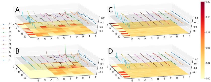
12:2   LSTM-TrajGAN: A Deep Learning Approach to Trajectory Privacy Protection

       still cause serious privacy threats since the spatial, temporal and thematic characteristics of
       trajectories can still be used as strong quasi-identifiers for linking the trajectories to their
       creators [2]. Another commonly used method is to aggregate trajectory points into geographic
       or administrative units so that their original locations are not revealed. Nevertheless, recent
       studies show that aggregation may fail to preserve user privacy and reduce the spatial
       resolution and effectiveness of spatial analysis [3, 28, 5]. For example, De Montjoye et al.
       [3] lower the resolution of a human mobility trace dataset through spatial and temporal
       aggregation to prevent the individuals from being identified, but the coarsened dataset only
       provides little anonymity. Thus, in order to achieve trajectory privacy protection more
       efficiently, we need to deal with the spatial and temporal characteristics of trajectory data
       more comprehensively.
            Current trajectory privacy protection studies focus on two research streams. One is
       the differential privacy approach to grouping and mixing the trajectories from different
       users so that the identification of individual trajectory data is converted into a k-anonymity
       problem [23, 31]. For example, the spatial cloaking approach mixes together the trajectory
       points between k users using k-anonymous cloaked spatial regions, making these trajectories
       k-anonymized [7]. Also, the mix-zones approach anonymizes the trajectory points in a
       mix-zone using pseudonyms and breaks the linkage between the former segment and the
       latter segment of the same trajectory that passes through a mix-zone [24]. Alternatively,
       the generalization-based approach first divides the points of k trajectories into different
       k-anonymized regions, and then reconstructs k new trajectories by uniformly selecting points
       from each k-anonymized regions and linking them together [22].
            Another research stream is called geomasking, which blurs the locations of original
       trajectory data by utilizing perturbation on the spatial dimension so that the original
       locations can be hidden or modified while spatial patterns may not be significantly affected
       [9, 5]. For example, Armstrong et al. [1] explored the privacy preservation ability and spatial
       analysis effectiveness of several types of geomasks. Kwan et al. [15] evaluated the spatial
       analysis effectiveness of three different random perturbation geomasks on lung-cancer deaths.
       Seidl et al. [26] applied grid masking and random perturbation on GPS trajectory data and
       evaluated the privacy protection performance. Gao et al. [5] investigated the effectiveness
       of random perturbation, gaussian perturbation, and aggregation on Twitter data as well as
       explored the privacy, analytics, and uncertainty level of each method.
            While these approaches all show the capabilities to protect trajectory privacy, they also
       expose several limitations. First of all, despite the diversity, the goal of these approaches
       largely is to obfuscate the trajectory locations and add more uncertainty to preserve privacy.
       However, the trade-off between the effectiveness of trajectory privacy protection and the
       utility for spatial and temporal analyses is still hard to control [18], and this issue has not been
       fully discussed or evaluated. Besides, current studies mainly focus on the spatial dimension
       of trajectory data whereas other semantics (e.g., temporal and thematic attributes) are
       rarely considered. In fact, these characteristics have been proven to be crucial for trajectory
       user identification [21]. Moreover, current approaches rely heavily on manually designed
       procedures. Once the procedure is disclosed, one may have the chance to recover the original
       trajectory data [28] (e.g., using reverse engineering). The “black-box” machine learning
       models may help to solve this issue.
            To this end, this research aims to explore the effectiveness of state-of-the-art deep learning
       approaches for trajectory privacy protection. We propose a novel LSTM-TrajGAN model
       that combines the Long Short-Term Memory (LSTM) recurrent neural network and the
       Generative Adversarial Network (GAN) structure together to generate privacy-preserving
       synthetic trajectories as alternatives to real trajectories for trajectory data sharing and
       publication. Two research questions (RQ) will be investigated in this work.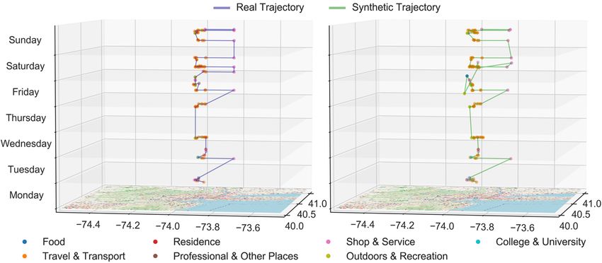
J. Rao, S. Gao, Y. Kang, and Q. Huang                                                                   12:3

    RQ 1: How effective is the proposed LSTM-TrajGAN model in protecting the trajectory
creators from being re-identified? (i.e., privacy protection effectiveness)
    RQ 2: Can the synthetic trajectories preserve the semantic features (spatial-temporal-
thematic characteristics) compared to real trajectories? (i.e., utility)
    The main contributions of our work are fourfold: (1) we propose an end-to-end deep
learning approach to generating privacy-preserving trajectory data. The procedure is simple
and highly secure (a GeoAI “black-box”); (2) we introduce a trajectory encoding model for
semantic trajectory encoding; (3) we design a new TrajLoss metric function to measure the
trajectory similarity losses for training deep learning models; and (4) we evaluate the privacy
protection effectiveness and the utility of the proposed model using real-world LBS data and
explore the trade-off between them.
    The remainder of the paper is organized as follows. Section 2 introduces our methodological
framework, including a trajectory encoding model, the LSTM-TrajGAN model, and the
TrajLoss function design. In section 3, we train and test our model using a city-scale weekly
trajectory dataset and compare with other commonly used trajectory privacy protection
methods. Both privacy protection effectiveness and utility are evaluated and compared
with baseline approaches. In section 4, we discuss the factors affecting privacy protection
effectiveness, the trade-off between privacy protection and utility, and the limitations of our
model. Section 5 summarizes this research and outlines the future work.

 2      Method

Inspired by the vision of the TrajGANs [18], we propose a new approach consisting of three
main components: (1) a Trajectory Encoding Model, which encodes GPS location coordinates,
temporal attributes, and other attributes such as point of interest (POI) category; (2) a
Trajectory Generator, which takes random noise and original trajectories as inputs to generate
synthetic trajectories as outputs; and (3) a Trajectory Discriminator, which takes trajectories
as inputs and determines them as “real” or “synthetic”.
    The overall workflow is described in Figure 1. The goal is to train an “intelligent” trajectory
generator that generates “realistic” synthetic trajectories to replace the original trajectories,
which preserves differential privacy in trajectory analysis tasks such as Trajectory-User
Linking (TUL) and trajectory data mining (e.g., work/home location clustering). Meanwhile,
it ensures the quality of multiple spatial or temporal summary analysis tasks. Such a
framework can serve as a trajectory privacy protection layer in trajectory data acquisition,
processing, and publication pipelines, which publish the synthetic alternatives rather than
the real trajectory data that may disclose individual privacy.

     Figure 1 The overall workflow of the proposed LSTM-TrajGAN approach.

                                                                                                      GIScience 2021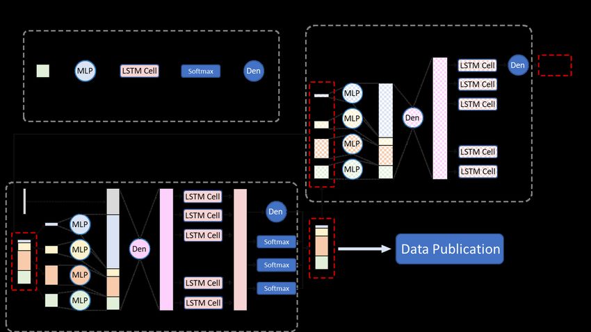
12:4 LSTM-TrajGAN: A Deep Learning Approach to Trajectory Privacy Protection
2.1 Trajectory Encoding
First, we introduce a trajectory encoding model that converts the original trajectory data
to a specific format that serves as the inputs for the LSTM-TrajGAN model. The main
reason for the encoding process is that the trajectory data usually contain various types
of attributes such as interval data (e.g., GPS coordinates, date and time), nominal data
(e.g., POI category), ordinal data (e.g., POI rating), and these data need to be converted
into valid numerical representations for training the deep learning model. Our trajectory
encoding model includes two parts: trajectory point encoding and trajectory padding.
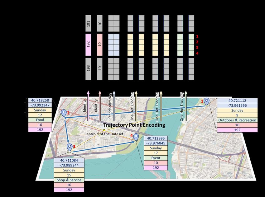
Trajectory Point Encoding
The trajectory point encoding process is illustrated in Figure 2. A semantic trajectory point
contains the following attributes: location, time, user id, trajectory id, and other optional
attributes such as POI category. For the location attribute, we standardize all the latitudes
and longitudes using the centroid of all the trajectories in the dataset to obtain the deviations
of the latitudes and longitudes from the centroid. In this way, the model can better learn
the spatial deviation pattern between different trajectory points. These deviation values will
be used as the numerical representations of the trajectory points for constructing spatial
embeddings [20].
For the temporal attributes and categorical attributes, we use the one-hot encoders (i.e.,
a representation process using dummy variables in machine learning) to encode the attributes
into high-dimensional binary vectors based on their vocabulary sizes. For example, the
“Day” attribute is encoded into 7-dimensional binary vectors, and “Monday” is represented
as [1, 0, 0, 0, 0, 0, 0]. Likewise, the “Hour” attribute is encoded into 24-dimensional binary
vectors, and the “Category” attribute is encoded into 10-dimensional binary vectors. Note
that we don’t encode the User ID and the Trajectory ID since they are only used to indicate
the user and the trajectory that the point belongs to.
Figure 2 An example for the trajectory point encoding process.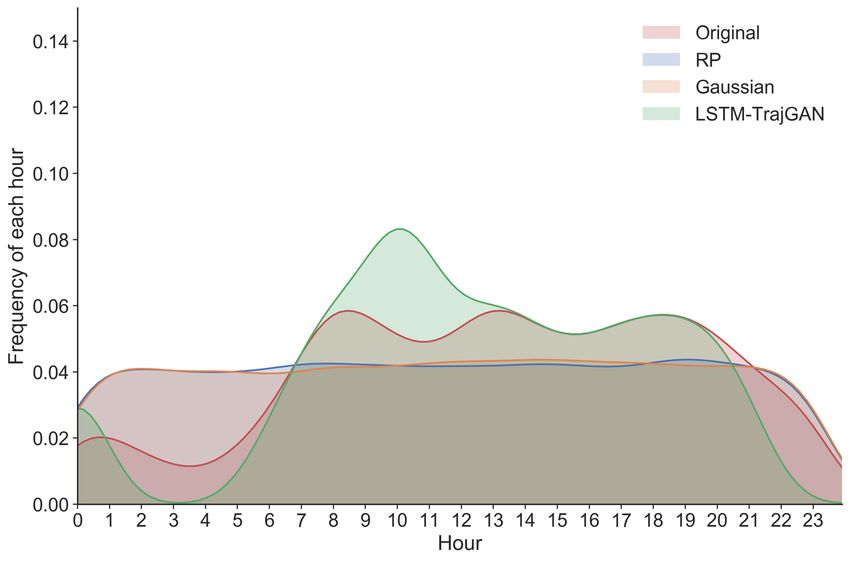
J. Rao, S. Gao, Y. Kang, and Q. Huang                                                                    12:5

Trajectory Padding
After the trajectory point encoding process, all the spatial, temporal, and thematic attributes
of a trajectory are stored in a multidimensional matrix, whose first dimension indicates the
index for each trajectory. Since the length of each trajectory data (i.e., the number of the
trajectory points) is a variable, we then apply the trajectory padding technique to make
sure all the trajectories have the same length as the longest trajectory. Specifically, we
use zero pre-padding to pad empty trajectory points (i.e., the points whose attributes are
all set to zero) to each trajectory until all the trajectories reached the same length as the
longest trajectory in the dataset. The main reason is that the data with the same size can be
utilized for batch processing and training the deep learning model, which would speed up the
training process. During the model training and inference processes, these padded trajectory
points will be masked (i.e., cut) and they won’t actually influence the neural network weight
updates and the derived results.

2.2    LSTM-TrajGAN Model
Figure 3 describes the neural network structure of the LSTM-TrajGAN Model. The trajectory
generator captures the data distribution and pattern of the real trajectory data and generates
synthetic trajectory data based on their corresponding original trajectory data and random
noise. In addition, the trajectory discriminator distinguishes whether the trajectory samples
come from the training set (i.e., real trajectory data) or the trajectory generator (i.e., synthetic
trajectory data). The goal of the trajectory generator is to generate “high-quality” synthetic
trajectories that can “fool” the trajectory discriminator, which leads to a two-player minimax
game between them. The generated synthetic trajectories aim to be competent for spatial
and temporal summary analysis, while having some degree of uncertainty and randomness
to protect the user privacy in trajectory analysis tasks with privacy issues involved. This
idea is reflected in the design and optimization of the LSTM-TrajGAN model.

   Figure 3 The neural network structure of the LSTM-TrajGAN Model.

Trajectory Generator
As is shown in Figure 3, the trajectory generator consists of five functional layers: the input
layer, the embedding layer, the feature fusion layer, the LSTM modeling layer, and the
regression/classification layer. The generator first takes the encoded real trajectories and

                                                                                                       GIScience 2021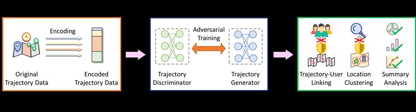
12:6   LSTM-TrajGAN: A Deep Learning Approach to Trajectory Privacy Protection

       random noise as inputs, and embeds trajectories using Multilayer Perceptrons (MLPs) [10].
       For the spatial dimension of a trajectory (i.e., pairs of latitude and longitude deviations),
       we embed each pair of them using a MLP to get 64-dimensional vectors. For the temporal
       dimension (e.g., day and hour) and categorical attributes (e.g., POI category), we use MLPs
       to embed them respectively and get fixed-length vectors based on their vocabulary sizes:

          espatial
           i       = φs (∆lati , ∆loni ; Wes )                                                         (1)

          eday
           i   = φd (viday ; Wed )                                                                     (2)

          ehour
           i    = φh (vihour ; Weh )                                                                   (3)

          ecategory
           i        = φc (vicategory ; Wec )                                                           (4)

           Where ∆lati and ∆loni stand for the latitude and longitude deviation of the i-th trajectory
       point; viday , vihour , and vicategory stand for the one-hot vectors for the day, hour, and category
       attributes of the i-th trajectory point; φs , φd , φh , and φc stand for the MLPs with an
       activation function – the Rectified Linear Unit (ReLU) for embedding the spatial, daily,
       hourly, and categorical attributes; Wes , Wed , Weh , and Wec are the embedding weight
       matrices for these MLPs; espatial i      , eday  hour
                                                   i , ei    , and ecategory
                                                                    i        are the embedded vectors for
       each attribute respectively. Note that the embedding weight matrices are shared among all
       trajectory points.
           After the embedding process, we further concatenate all the vectors and the random
       noise, and then use a dense layer to fuse them into 100-dimensional vectors. By leveraging
       the feature fusion, we take the advantage of all the spatial, temporal, and categorical
       characteristics of each trajectory point and fuse them together to support spatiotemporal
       trajectory modeling and generation. In the LSTM modeling layer, we use a many-to-many
       LSTM structure that takes a sequence with specific time steps as the input and generates
       a sequence with the same time steps as the output. Recurrent models such as LSTM are
       proven to be efficient in spatial-temporal sequence modeling and prediction [8, 21]. Given
       the dimension of the fused feature, we assign 100 units in the LSTM model and feed the
       fused features to the model:

          H = LST M (F ; Wlstm )                                                                       (5)

           Where F represents for the fused features of all the trajectory points in a trajectory (i.e.,
       F = [f0 , f1 , ..., fmaxlength−1 ]), in which fi is the fused feature vector for the i-th trajectory
       point; H is the output of the LSTM model, which has the same time step dimensions as the
       input (i.e., H = [h0 , h1 , ..., hmaxlength−1 ], in which hi is the modeling output vector for fi );
       Wlstm is the weight matrix of the LSTM model.
           Finally, we decode the synthetic trajectory data from the output H of the LSTM modeling
       layer. Each feature vector hi in H is a 100-dimensional vector containing the spatial, temporal,
       and categorical characteristics of a synthetic trajectory point. To decode the latitude and
       longitude deviations, we use a dense layer with two units and use the tanh hyperbolic tangent
       function. In addition, we further stretch the output range to make sure its range covers all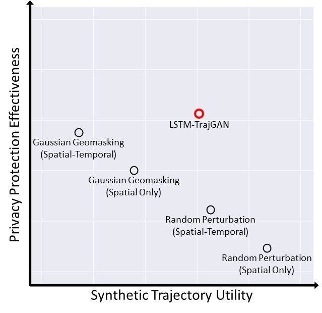
J. Rao, S. Gao, Y. Kang, and Q. Huang                                                                     12:7

the possible deviation values. To decode the day, hour and category attributes, we use dense
layers that have as many units as the vocabulary sizes, and use the sof tmax normalized
exponential function to recover the one-hot representation of these attributes:

   (∆lat0i , ∆lon0i ) = Ds (hi ; Wds )                                                           (6)

   vi0day = Dd (hi ; Wdd )                                                                       (7)

   vi0hour = Dh (hi ; Wdh )                                                                      (8)

   vi0category = Dc (hi ; Wdc )                                                                  (9)

    Where ∆lat0i and ∆lon0i are the latitude and longitude deviations of the i-th synthetic
trajectory point; vi0day , vi0hour , and vi0category represent the one-hot vectors for the day, hour,
and category attributes of the i-th synthetic trajectory point; Ds , Dd , Dh , and Dc represent
the dense layers with a tanh or sof tmax function for decoding the location, day, hour, and
category attributes; Wds , Wdd , Wdh , and Wdc are the decoding weight matrices for these
dense layers; Note that the decoding weight matrices are shared among all trajectory points.

Trajectory Discriminator
As is shown in Figure 3, the trajectory discriminator has a very similar structure as the
trajectory generator. The major differences between them are:
    (1) The discriminator only takes trajectory data as the input (no random noise needed);
    (2) We use a many-to-one LSTM model that takes the features with time steps as the
input and make one scalar as the output:

   h = LST M (F ; Wlstmd )                                                                      (10)

    Where F represents for the fused features of all the trajectory points in a trajectory (i.e.,
F = [f0 , f1 , ..., fmaxlength−1 ]), in which fi is the fused feature vector for the i-th trajectory
point; Wlstmd is the weight matrix of the LSTM model; and h is the output scalar of the
LSTM model.
    (3) We use a one-unit dense layer with the sigmoid activation function to make binary
classification (real or synthetic) on the scalar output:

   Od = Dbc (h; Wbc )                                                                           (11)

    Where Dbc is the one-unit dense layer with a sigmoid function used to make binary
classification, and Wbc is its weight matrix; Od is the final output of the discriminator.

2.3    TrajLoss for Measuring Trajectory Similarity Losses
The original GAN is designed to optimize the following objective function [6]:

   O(D, G) = min max(Ex∼pdata (x) [logD(x)] + Ez∼pz (z) [log(1 − D(G(z)))])                     (12)
                  G    D

                                                                                                        GIScience 2021
12:8 LSTM-TrajGAN: A Deep Learning Approach to Trajectory Privacy Protection
Where pdata (x) represents the distribution of the real data samples; pz (z) represents a prior
on noise variables; D(x) represents the probability that x came from pdata (x); G(z) represents
a mapping from pz (z) to pdata (x). The generator aims to minimize Ez∼pz (z) [log(1−D(G(z)))]
while the discriminator aims to maximize Ex∼pdata (x) [logD(x)] + Ez∼pz (z) [log(1 − D(G(z)))],
leading to a two-player minimax game.
According to the objective function O(D, G), the loss function for the discriminator can
be considered as a Binary Cross-Entropy (BCE) loss function (LBCE ), which will also be
used in training the generator. However, different from the original GAN, we need the real
trajectory data as inputs. Thus, we design a new loss metric function named TrajLoss to
further measure the similarity losses between the real trajectory data and the synthetic
trajectory data in spatial, temporal and categorical dimensions, and use this loss function to
train the generator. The TrajLoss is defined as follows:
T rajLoss(y r , y p , tr , ts ) = αLBCE (y r , y p ) + βLs (tr , ts ) + γLt (tr , ts ) + cLc (tr , ts ) (13)
Where y r and y p represent the ground truth label and the prediction result of the
trajectory by the discriminator, respectively; tr and ts represent the real trajectory and the
corresponding synthetic trajectory; LBCE is the original binary cross-entropy loss from the
discriminator; Ls , Lt , and Lc are the spatial similarity loss, temporal similarity loss, and the
categorical similarity loss between the real and synthetic trajectories, respectively; α, β, γ,
and c are the weights for these losses and can be assigned differently for different scenarios.
In this paper, we use the L2 loss (i.e., least square errors) for Ls as a recent study [8]
shows that the L2 loss is effective in measuring trajectory spatial similarity. Besides, we
choose the Softmax Cross-Entropy (SCE) as the loss function for Lt and Lc since they are
all regarded as multi-classification problems in this framework, and thus can be optimized
using SCE. During the model training, the weights of the generator will be updated by the
TrajLoss to improve the quality of the synthetic trajectory data.
3 Experiments
To address the abovementioned RQ1, this section first evaluates the effectiveness of trajectory
privacy protection using the proposed LSTM-TrajGAN model on a classic LBS task:
Trajectory-User Linking (TUL), which identifies users from trajectories and link trajectories
to them [4]. TUL is an essential task in geo-tagged social media applications and receives
increasing privacy concerns [4, 30, 21]. The evaluation can be regarded as an adversarial
experiment: we train the LSTM-TrajGAN model and use the generated synthetic trajectories
to suppress the accuracy of a state-of-the-art TUL algorithm. We also compare our approach
with the other two commonly used location privacy protection methods: Random Perturbation
and Gaussian Geomasking.
Meanwhile, to address the RQ2 for verifying the utility of the proposed model (i.e., the
usefulness of the synthetic trajectories in analysis), we also explore the spatial and temporal
characteristics of the synthetic trajectories to see if they preserve sufficient information from
the original trajectories to further support spatial and temporal analyses.
3.1 Trajectory-User Linking
Dataset
We use the Foursquare weekly trajectory dataset in New York City (NYC) provided by Petry
et al. [21], which is extracted from the Foursquare NYC check-ins dataset [29]. We only
keep the user ID, trajectory ID, location, hour, day, and category attributes and removeJ. Rao, S. Gao, Y. Kang, and Q. Huang 12:9
other attributes (e.g., price tier, rating, weather). The summary of the attributes is shown
in Table 1. There are 193 users, 3,079 trajectories and 66,962 trajectory points in total in
the dataset. We use 2/3 of the trajectories for training the LSTM-TrajGAN model and 1/3
for testing as suggested in [21].
Training and Evaluation
We train the LSTM-TrajGAN model on the training set for 2,000 epochs with several default
training hyperparameters (e.g., we use an adam optimizer with a learning rate of 0.001 and
set the batch size to 256). After the training process, the trajectory data from the test set as
well as random noise are then used as the input of the generator to get synthetic trajectory
data. A visualization example of a real trajectory from the test data and its corresponding
synthetic trajectory generated by our model is shown in Figure 4 as a comparison. Next, we
use the MARC (Multiple-Aspect tRajectory Classifier [21]), a start-of-the-art TUL algorithm,
to perform the TUL task on both the test data and our synthetic data. Same as [21], we
evaluate the TUL accuracy with five commonly used metrics: ACC@1 (Top-1 Accuracy,
showing the model’s ability to have the correct label to be the most probable label candidate),
ACC@5 (Top-5 Accuracy, showing the model’s ability to have the correct label among the
top 5 most probable label candidates), Macro-P (Macro Precision, the mean precision among
all classes), Macro-R (Macro Recall, the mean recall among all classes), and Macro-F1 (the
harmonic mean of Macro-P and Macro-R). For comparison, we also evaluate the privacy
protection effectiveness of Random Perturbation (spatial filter: within 1 km; temporal filter:
within 24 hours) and Gaussian Geomasking (spatial filter: standard deviation = 0.001;
temporal filter: within 24 hours).
Figure 4 The visualization example of a real trajectory from the test data and its corresponding
synthetic trajectory generated by our model.
The results are shown in Table 2. The higher the TUL accuracy, the worse the capability
for trajectory privacy protection. One can conclude that the synthetic data generated by
the LSTM-TrajGAN successfully suppress the scores in the four metrics (ACC@1, Macro-P,
Macro-R, and Macro-F) from over 0.900 to around 0.400. The Top-5 Accuracy is decreased
from over 0.976 to 0.722. The results show that our model can effectively prevent users
from being identified by analyzing the trajectories. Additionally, Random Perturbation has
limited effectiveness in protecting trajectory privacy regarding the TUL task, and Gaussian
Geomasking works better while still has higher scores than our model. The results also indicate
that leveraging both spatial and temporal dimensions of the trajectories simultaneously leads
to better privacy-preserving performance than using only the spatial dimension.
GIScience 202112:10 LSTM-TrajGAN: A Deep Learning Approach to Trajectory Privacy Protection
Table 1 The summary of the Foursquare NYC weekly trajectory dataset.
Attribute Type Number / Range
Trajectory ID integer 3,079
User ID integer 193
Latitude float (40.550852, 40.988332)
Longitude float (-74.269644, -73.685767)
Hour integer 24
Day string 7
Category string 10
Table 2 The privacy protection effectiveness of different privacy protection methods on the TUL
task (RP stands for Random Perturbation; Gaussian stands for Gaussian Geomasking).
Method ACC@1 ACC@5 Macro-F1 Macro-P Macro-R
Original 0.938 0.976 0.925 0.937 0.927
RP (Spatial Only) 0.777 0.934 0.758 0.806 0.764
RP (Spatial-Temporal) 0.668 0.888 0.640 0.711 0.654
Gaussian (Spatial Only) 0.561 0.832 0.522 0.573 0.537
Gaussian (Spatial-Temporal) 0.486 0.766 0.431 0.488 0.470
LSTM-TrajGAN 0.459 0.722 0.381 0.429 0.428
3.2 Synthetic Trajectory Characteristics Analysis
Here, we analyze the spatial and temporal characteristics and other properties of the synthetic
trajectories generated by the LSTM-TrajGAN to evaluate its utility (RQ2).
Spatial Characteristics
The spatial characteristics are explored based on two metrics: the Hausdorff Distance and the
Jaccard Index. The Hausdorff Distance is a metric for measuring the distance between two
point sets in a metric space and has been widely used for measuring the spatial dissimilarity
between two trajectories. The Jaccard Index, also known as the Intersection over Union,
is an efficient metric for measuring how much the two sample sets or regions overlap, and
we use this to indicate the similarity of the activity spaces between two trajectories [18].
We calculate the Hausdorff Distance between each pair of the original and the synthetic
trajectories. Likewise, we also calculate the Jaccard Index between the convex hulls of them
since the convex hull can generally represent the activity space of LBS users [16]. Table 3
presents the summary of these metrics.
It shows that Random Perturbation has the smallest average Hausdorff Distance (0.004)
and the largest average Jaccard Index (0.763), which makes sense since it only makes a limited
influence on the spatial dimension of the trajectories. While such a method could preserve
spatial similarity well, it sacrifices the location privacy. Our model performs better than
Gaussian Geomasking on these two metrics and also better suppresses the abovementioned
TUL metrics, which strikes a better balance between spatial similarity and location privacy.
Temporal Characteristics
We also explore the temporal characteristics based on the visualization of two summary
indicators: temporal visit probability distribution for each POI category, and overall temporal
visit frequency distribution. We count the frequencies of visits to each POI category at eachJ. Rao, S. Gao, Y. Kang, and Q. Huang 12:11
Table 3 Spatial characteristics evaluation based on Hausdorff Distance and Jaccard Index (RP
stands for Random Perturbation; Gaussian stands for Gaussian Geomasking).
Hausdorff Distance Jaccard Index
Method
Min Max Std Mean Min Max Std Mean
RP 0.001 0.006 0.001 0.004 0.000 0.977 0.194 0.763
Gaussian 0.001 0.034 0.005 0.014 0.000 0.933 0.231 0.478
LSTM-TrajGAN 0.001 0.046 0.006 0.012 0.000 0.951 0.234 0.582
hour in original trajectories and the synthetic trajectories using three different approaches,
and convert them into probability distribution matrices (Figure 5), in which the temporal
patterns and the temporal similarity can be analyzed and compared.
Figure 5 The hourly temporal visit probability distribution for each POI category by (A)
Original data, (B) LSTM-TrajGAN, (C) Random Perturbation (within 24 hours), and (D) Gaussian
Geomasking (within 24 hours) data (F: Food; T: Travel & Transport; R: Residence; P: Professional
& Other Places; S: Shop & Service; O: Outdoors & Recreation; C: College & University; A: Arts &
Entertainment; N: Nightlife Spot; E: Event).
(a) Overall temporal visit frequency (b) Overall categorical visit frequency
distribution. distribution.
Figure 6 Overall temporal visit frequency distribution and overall categorical visit frequency
distribution (RP stands for Random Perturbation; Gaussian stands for Gaussian Geomasking).
It shows that the temporal visit probability distribution from LSTM-TrajGAN shares a
large commonality with that from the original data, which embodies a significant temporal
similarity. Some parts of the result by LSTM-TrajGAN (i.e., categories C and E) have
near zero visit probability since these categories rarely appear in training data and thus
the model doesn’t learn sufficient information to make intelligent predictions on them. As
GIScience 202112:12 LSTM-TrajGAN: A Deep Learning Approach to Trajectory Privacy Protection
the comparisons, the temporal visit probability from Random Perturbation and Gaussian
Geomasking show neither temporal similarity with the original data nor significant temporal
patterns over 24 hours (except for the Event category).
Besides, we investigate the overall temporal and categorical visit frequency distribution
(Figure 6a and Figure 6b). The overall temporal visit frequency distribution from our model
can better fits the original data (Pearson Coefficient: 0.761) than Random Perturbation
(0.536) and Gaussian Geomasking (0.535). The overall categorical visit frequency distribution
also fits well (0.889). Hence, we conclude that our model generally well preserves both
temporal and categorical characteristics.
4 Discussion
This section discusses the factors that may affect the privacy protection effectiveness of the
LSTM-TrajGAN model, and the trade-off between the privacy protection effectiveness and
the utility. Finally, we discuss the limitations of our approach.
4.1 Factors Affecting Privacy Protection Effectiveness
Training and Optimization Settings
We first explore how the different learning rates, loss metric functions, and random noise
data affect the metric scores in the TUL task compared with the baseline setting (i.e., the
learning rate = 0.001; the spatial dimension = 64; and the TrajLoss metric function during
training). As shown in Table 4, different random noise data have small influences on the
metrics, which in fact contributes to the potential generalizability of the proposed approach
for generating privacy-preserving trajectory data. We also found that the selection of the
learning rate may have a great influence on the metrics. A higher learning rate (0.002) makes
the model converge faster, generating the synthetic trajectories that have less uncertainty
and share more characteristics with the original trajectories, leading to higher TUL metric
scores and vice versa. Although this is not always the case, the learning rate should be
carefully set to balance the trajectory utility and privacy protection effectiveness.
Table 4 The metrics in the TUL task based on the synthetic trajectories by LSTM-TrajGAN
using different training and optimization settings as well as different spatial embedding dimensions.
LSTM-TrajGAN ACC@1 ACC@5 Macro-F1 Macro-P Macro-R
Baseline 0.459 0.722 0.381 0.429 0.428
Different Random Noise 0.466 0.741 0.398 0.451 0.436
Higher Learning Rate (0.002) 0.841 0.959 0.824 0.855 0.828
Lower Learning Rate (0.00002) 0.055 0.157 0.029 0.047 0.054
Higher Spatial Dimensions (128) 0.510 0.811 0.504 0.513 0.513
Lower Spatial Dimensions (32) 0.426 0.703 0.396 0.402 0.392
TrajLoss without Spatial Loss 0.047 0.176 0.030 0.037 0.042
TrajLoss without Temporal Loss 0.093 0.252 0.076 0.119 0.089
TrajLoss without Categorical Loss 0.354 0.623 0.311 0.386 0.346
No TrajLoss 0.010 0.032 0.002 0.001 0.007
In addition, we also investigate how the TrajLoss metric function contributes to the
training. When removing the Spatial Loss or the Temporal Loss from the TrajLoss function,
the metric scores fall dramatically, implying that the synthetic trajectories fail to preserveJ. Rao, S. Gao, Y. Kang, and Q. Huang 12:13
the spatial or temporal characteristics of the original trajectories. By comparison, removing
the Categorical Loss only has a limited impact on the metric scores. Not surprisingly,
removing the whole TrajLoss function results in losing spatiotemporal characteristics and
thus getting the lowest TUL metric scores. We conclude that the spatial and the temporal
dimensions represent the essential characteristics of a trajectory and hence need to be taken
into consideration explicitly in the privacy protection approaches.
Spatial Embedding
Since the embedding of temporal attributes and categorical attributes is based on their
vocabulary sizes, we mainly discuss the spatial embedding. The commonly used methods
for spatial embedding are Multilayer Perceptron (MLP) and the Geohash algorithm. For
example, Gupta et al. [8] use a MLP to embed the location of each person to obtain a
fixed-length vector and use the vector as the input for an LSTM model to generate human
trajectory. Petry et al. [21] introduce a binary Geohash algorithm, in which they first use
the Geohash algorithm to divide the area into grid cells and then encode the latitude and
longitude as a character string, and finally convert the string into a binary fixed-length vector
as the representation for the spatial dimension of each trajectory point.
We use MLPs in the generator and the discriminator to embed the spatial dimension,
but we implement them in a different way. Instead of directly embedding the coordinates,
we first derive the deviations of latitudes and longitudes from the centroid of all trajectory
locations, and then we embed these deviations into 64-dimensional vectors using MLP. There
are two considerations: (1) On the one hand, unlike the trajectory classification task in [21],
our goal is to generate synthetic trajectories, which means we need to decode the coordinates
out from the hidden features in the model, and therefore using binary Geohash may lead to
difficulties in learning the valid representation of coordinates, in designing the proper spatial
loss, and in back-propagating the errors; and (2) On the other hand, unlike the restricted
prediction area described by a Cartesian coordinate system in [8], the prediction area in our
task is on the city scale, and the difference between two GPS coordinates only appears after
the decimal point. It would be a grand challenge for the model to learn and predict the
coordinates with only subtle changes. As such, we standardized the coordinates to make the
difference between two locations more significant for the model to learn. Recent studies also
indicate that scattering the locations based on deviations may help preserve privacy [5].
We also explore how the spatial embedding dimensions affect the metrics in the TUL
task. As is presented in Table 4, embedding the location information into a vector with
higher dimensions (e.g., 128) improves the TUL metric scores and vice versa. This makes
sense since vectors in a higher-dimensional space are usually able to extract and embed more
information than that in a lower-dimensional space. However, this also involves a trade-off
between location accuracy and computational effort due to the limitation of physical devices.
4.2 The Trade-off between Privacy Protection Effectiveness and Utility
Generally speaking, specific trajectory analysis tasks may rely on different types of trajectory
data (e.g., POI-based or road network-based) or different requirements (e.g., road extraction
requires the location of each trajectory point to be precise), making it challenging to design
a generic privacy protection method. However, we can evaluate a method by some specific
criteria to determine its application scenarios, and even design a method based on this
consideration to cover as many scenarios as possible. Inspired by the evaluation framework
that involves the privacy, analytics, and uncertainty [5], we investigate the relationship
GIScience 202112:14 LSTM-TrajGAN: A Deep Learning Approach to Trajectory Privacy Protection
between privacy protection effectiveness and utility. Figure 7a demonstrates the performance
of each method. It is worth noting that the placement of each method is estimated from our
experiment. We believe that the consideration of this relationship would help choose and
design proper trajectory privacy protection methods for specific scenarios.
(a) (b)
Figure 7 (a) The performance of each method in privacy protection effectiveness and utility; (b)
The trade-off between the effectiveness of privacy protection (presented by TUL Top-5 Accuracy) and
the preservation of spatial characteristics preservation (presented by Average Hausdorff Distance).
Sometimes the relationship between the privacy protection effectiveness and the utility
is somewhat contradictory: we hope that the synthetic data are less similar to the original
data to protect privacy while still preserving some similarities as good alternatives for
spatiotemporal modeling or analyses. This may result in a “catch-22 situation”. As an
end-to-end deep learning model, the LSTM-TrajGAN is able to monitor and quantify this
relationship during training and help to find the best-balanced parameter settings. For
example, as training progresses, the TUL accuracy (Top-5 Accuracy) increases while the
Average Hausdorff Distance decreases (Figure 7b). Carefully selecting the model weight
from different epochs based on this relationship could ensure that the synthetic trajectories
preserve spatiotemporal characteristics to some extent while maintaining a low TUL accuracy
as needed, thereby balancing the privacy protection effectiveness and the utility of synthetic
trajectories.
4.3 Limitations
Several limitations exist in our current approach. First, compared to traditional geomasking
techniques that blur the existing trajectories, our deep learning model that generates new
trajectories leads to a much higher computational effort and also needs an additional training
process before its deployment in applications. Second, we focus on the TUL task and analyzed
spatial and temporal characteristics of the synthetic trajectories, which reflects their potential
for privacy-preserving trajectory analysis, but more specific evaluations are not investigated
yet. Third, our model generates only the synthetic trajectories that have the same length as
the original trajectories. Finally, our model currently focuses on city-scale trajectories, and
the deviation-based location representation may not be suitable for global-scale trajectories.
These limitations will be further explored in our future work.J. Rao, S. Gao, Y. Kang, and Q. Huang 12:15
5 Conclusion and Future Work
This research proposes a novel LSTM-TrajGAN approach, i.e., a deep learning model
that combines the LSTM recurrent neural network and the GAN structure to generate
privacy-preserving synthetic trajectories for trajectory data publication. We utilize the
idea of adversarial training in the model design, train our model on a Foursquare NYC
weekly trajectory dataset, and evaluate its privacy protection effectiveness in the TUL task.
Regarding the two research questions we posed at the beginning of this research, the results
show that (RQ1) our model can generate the spatial-temporal synthetic trajectories that
prevent the trajectory creators (i.e., users) from being re-identified to certain degree and
(RQ2) keep some spatial, temporal, and thematic characteristics of the original trajectories.
Additionally, the results show that the model has the potentials for supporting further
spatial or temporal analyses. Lastly, we explored the factors affecting the privacy protection
effectiveness and discussed the trade-off between model effectiveness and utility in general.
The design of a new loss function TrajLoss offers new insights into the development of
spatially explicit artificial intelligence techniques for advancing GeoAI [13].
Our future work will focus on improving the trajectory similarity loss metric function,
extending our framework to global-scale trajectory datasets, generating custom variable-
length synthetic trajectory data, exploring potential privacy attack and defense strategies,
and evaluating the privacy protection effectiveness and utility of our model in other trajectory
data mining and analysis tasks.
References
1 Marc P Armstrong, Gerard Rushton, Dale L Zimmerman, et al. Geographically masking
health data to preserve confidentiality. Statistics in Medicine, 18(5):497–525, 1999.
2 Chi-Yin Chow and Mohamed F Mokbel. Trajectory privacy in location-based services and
data publication. ACM SIGKDD Explorations Newsletter, 13(1):19–29, 2011.
3 Yves-Alexandre De Montjoye, César A Hidalgo, Michel Verleysen, and Vincent D Blondel.
Unique in the crowd: The privacy bounds of human mobility. Scientific reports, 3:1376, 2013.
4 Qiang Gao, Fan Zhou, Kunpeng Zhang, Goce Trajcevski, Xucheng Luo, and Fengli Zhang.
Identifying human mobility via trajectory embeddings. In International Joint Conferences on
Artificial Intelligence, pages 1689–1695, 2017.
5 Song Gao, Jinmeng Rao, Xinyi Liu, Yuhao Kang, Qunying Huang, and Joseph App. Exploring
the effectiveness of geomasking techniques for protecting the geoprivacy of Twitter users.
Journal of Spatial Information Science, 2019(19):105–129, 2019.
6 Ian Goodfellow, Jean Pouget-Abadie, Mehdi Mirza, Bing Xu, David Warde-Farley, Sherjil
Ozair, Aaron Courville, and Yoshua Bengio. Generative adversarial nets. In Advances in
Neural Information Processing Systems, pages 2672–2680, 2014.
7 Marco Gruteser and Dirk Grunwald. Anonymous usage of location-based services through
spatial and temporal cloaking. In Proceedings of the 1st international conference on Mobile
systems, applications and services, pages 31–42. ACM, 2003.
8 Agrim Gupta, Justin Johnson, Li Fei-Fei, Silvio Savarese, and Alexandre Alahi. Social GAN:
Socially acceptable trajectories with generative adversarial networks. In Proceedings of the
IEEE Conference on Computer Vision and Pattern Recognition, pages 2255–2264, 2018.
9 Kristen H Hampton, Molly K Fitch, William B Allshouse, Irene A Doherty, Dionne C Gesink,
Peter A Leone, Marc L Serre, and William C Miller. Mapping health data: Improved privacy
protection with donut method geomasking. American Journal of Epidemiology, 172(9):1062–
1069, 2010.
10 Simon Haykin. Neural networks: a comprehensive foundation. Prentice Hall PTR, 1994.
GIScience 202112:16 LSTM-TrajGAN: A Deep Learning Approach to Trajectory Privacy Protection
11 Qunying Huang and David WS Wong. Modeling and visualizing regular human mobility
patterns with uncertainty: An example using twitter data. Annals of the Association of
American Geographers, 105(6):1179–1197, 2015. doi:10.1080/00045608.2015.1081120.
12 Qunying Huang and Yu Xiao. Geographic situational awareness: Mining tweets for disaster
preparedness, emergency response, impact, and recovery. ISPRS International Journal of
Geo-Information, 4(3):1549–1568, 2015.
13 Krzysztof Janowicz, Song Gao, Grant McKenzie, Yingjie Hu, and Budhendra Bhaduri. GeoAI:
Spatially explicit artificial intelligence techniques for geographic knowledge discovery and
beyond, 2020.
14 Carsten Keßler and Grant McKenzie. A geoprivacy manifesto. Transactions in GIS, 22(1):3–19,
2018.
15 Mei-Po Kwan, Irene Casas, and Ben Schmitz. Protection of geoprivacy and accuracy of spatial
information: How effective are geographical masks? Cartographica: The International Journal
for Geographic Information and Geovisualization, 39(2):15–28, 2004.
16 Jae Hyun Lee, Adam W Davis, Seo Youn Yoon, and K. G. Goulias. Activity space estimation
with longitudinal observations of social media data. Transportation, 43(6):955–977, 2016.
17 Mingxiao Li, Song Gao, Feng Lu, Huan Tong, and Hengcai Zhang. Dynamic estimation of
individual exposure levels to air pollution using trajectories reconstructed from mobile phone
data. International Journal of Environmental Research and Public Health, 16(22):4522, 2019.
18 Xi Liu, Hanzhou Chen, and Clio Andris. trajGANs: Using generative adversarial networks
for geo-privacy protection of trajectory data (vision paper). In Location Privacy and Security
Workshop 2018 in conjunction with GIScience ’18, pages 1–7, 2018.
19 Yu Liu, Xi Liu, Song Gao, Li Gong, Chaogui Kang, Ye Zhi, Guanghua Chi, and Li Shi. Social
sensing: A new approach to understanding our socioeconomic environments. Annals of the
Association of American Geographers, 105(3):512–530, 2015.
20 Gengchen Mai, Krzysztof Janowicz, Bo Yan, Rui Zhu, Ling Cai, and Ni Lao. Multi-scale
representation learning for spatial feature distributions using grid cells. In The Eighth
International Conference on Learning Representations. openreview, 2020.
21 Lucas May Petry, Camila Silva, Andrea Esuli, Chiara Renso, and Vania Bogorny. Marc:
a robust method for multiple-aspect trajectory classification via space, time, and semantic
embeddings. International Journal of Geographical Information Science, pages 1–23, 2020.
22 Mehmet Ercan Nergiz, Maurizio Atzori, and Yucel Saygin. Towards trajectory anonymization:
a generalization-based approach. In Proceedings of the SIGSPATIAL ACM GIS 2008
International Workshop on Security and Privacy in GIS and LBS, pages 52–61, 2008.
23 Ben Niu, Qinghua Li, Xiaoyan Zhu, Guohong Cao, and Hui Li. Achieving k-anonymity
in privacy-aware location-based services. In IEEE INFOCOM 2014-IEEE Conference on
Computer Communications, pages 754–762. IEEE, 2014.
24 Balaji Palanisamy and Ling Liu. Mobimix: Protecting location privacy with mix-zones over
road networks. In 2011 IEEE 27th International Conference on Data Engineering, pages
494–505. IEEE, 2011.
25 Yoo Min Park and Mei-Po Kwan. Individual exposure estimates may be erroneous when
spatiotemporal variability of air pollution and human mobility are ignored. Health & place,
43:85–94, 2017.
26 Dara E Seidl, Piotr Jankowski, and Ming-Hsiang Tsou. Privacy and spatial pattern preservation
in masked GPS trajectory data. International Journal of Geographical Information Science,
30(4):785–800, 2016.
27 Zheye Wang, Xinyue Ye, and Ming-Hsiang Tsou. Spatial, temporal, and content analysis of
twitter for wildfire hazards. Natural Hazards, 83(1):523–540, 2016.
28 Fengli Xu, Zhen Tu, Yong Li, Pengyu Zhang, Xiaoming Fu, and Depeng Jin. Trajectory
recovery from ash: User privacy is not preserved in aggregated mobility data. In Proceedings
of the 26th International Conference on World Wide Web, pages 1241–1250, 2017.J. Rao, S. Gao, Y. Kang, and Q. Huang 12:17
29 Dingqi Yang, Daqing Zhang, Vincent W Zheng, and Zhiyong Yu. Modeling user activity
preference by leveraging user spatial temporal characteristics in LBSNs. IEEE Transactions
on Systems, Man, and Cybernetics: Systems, 45(1):129–142, 2014.
30 Fan Zhou, Qiang Gao, Goce Trajcevski, Kunpeng Zhang, Ting Zhong, and Fengli Zhang.
Trajectory-user linking via variational autoencoder. In International Joint Conferences on
Artificial Intelligence, pages 3212–3218, 2018.
31 Huaijie Zhu, Xiaochun Yang, Bin Wang, Leixia Wang, and Wang-Chien Lee. Private trajectory
data publication for trajectory classification. In International Conference on Web Information
Systems and Applications, pages 347–360. Springer, 2019.
GIScience 2021You can also read