Mariners Weather Log - Voluntary Observing Ship Program
←
→
Page content transcription
If your browser does not render page correctly, please read the page content below
Mariners Weather Log
Vol. 43, No. 2 August 1999
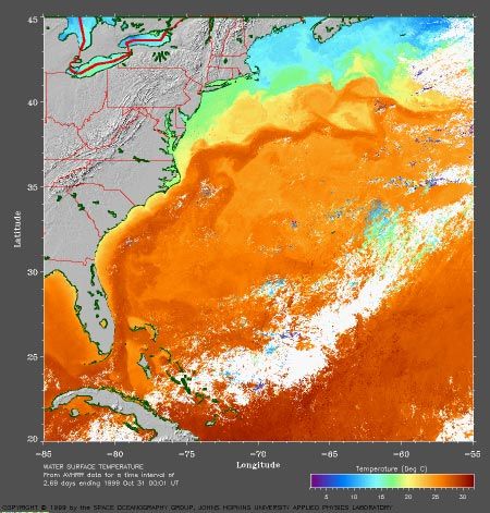
Sea Surface Temperature image of the North Atlantic Ocean
showing the Gulf Stream System (intense currents on the western side
of the North Atlantic Ocean). For centuries, the only information on
ocean surface currents came from mariners. With the introduction of
satellites, a view of ocean currents can be seen on a daily basis.
Mariners Weather Log

                  Mariners Weather Log                                               From the Editorial Supervisor

                                                                                     As the 20th century ends and we enter the new
                                                                                     millennium, now, as never before, the topics of
                                                                                     weather and climate are at the forefront of specula-
                                                                                     tion and study. In the past, predictions about
                                                                                     humanity’s future did not take account of changing
                 U.S. Department of Commerce
                                                                                     climate, disappearing forests, spreading deserts,
                  William M. Daley, Secretary                                        rising sea levels, and the like. Now, as we are all
                                                                                     aware, changes like these are likely to affect our
                     National Oceanic and                                            future profoundly. In light of this, the cover of this
                  Atmospheric Administration                                         issue was chosen to recognize the impact that ocean
               Dr. D. James Baker, Administrator
                                                                                     currents such as the Gulf Stream have on weather
                National Weather Service                                             and climate.
                    John J. Kelly, Jr.,
      Assistant Administrator for Weather Services                                   The Gulf Stream impacts weather both in the United
                                                                                     States and Europe. Along the United States east
               National Environmental Satellite,
                Data, and Information Service                                        coast, a class of storms, referred to as “Nor’Easters”
                     Robert S. Winokur,                                              can form in winter near or over the Gulf Stream as
                   Assistant Administrator                                           cold air from the North American continent meets the
                                                                                     Gulf Stream warm air. Development of these storms
                          Editorial Supervisor
                            Martin S. Baron                                          can sometimes be explosive, with central pressures
                                                                                     dropping 18 mb (0.5 inches) or more in less than 24
                                 Editor                                              hours (called “bombs” in our North Atlantic Marine
                             Mary Ann Burke                                          Weather Reviews). Further east, the Gulf Stream has
                                                                                     a major moderating impact on the weather of Iceland,
                                                                                     Western Europe, the Azores, and the Canary Islands.

 The Secretary of Commerce has determined that the publication of this               It is widely believed that ocean currents, along with
 periodical is necessary in the transaction of the public business required by law   phenomena such as El Niño and La Niña are key to
 of this department. Use of funds for printing this periodical has been approved
 by the director of the Office of Management and Budget through December             understanding and predicting weather and climate
 1999.
                                                                                     change. They will be at the forefront of climate
 The Mariners Weather Log (ISSN: 0025-3367) is published by the National             research throughout the 21st century. We will con-
 Weather Service, Office of Meteorology, Integrated Hydrometeorological
 Services Core, Silver Spring, Maryland, (301) 713-1677, Ext. 134. Funding is        tinue to run articles on these subjects as they become
 provided by the National Weather Service, National Environmental Satellite,         available.h
 Data, and Information Service, and the United States Navy. Data is provided by
 the National Climatic Data Center.

 Articles, photographs, and letters should be sent to:
                                                                                         Some Important Webpage Addresses
 Mr. Martin S. Baron, Editorial Supervisor
 Mariners Weather Log                                                                NOAA                        http://www.noaa.gov
                                                                                     National Weather Service    http://www.nws.noaa.gov
 National Weather Service, NOAA                                                      VOS Program                 http://www.vos.noaa.gov
 1325 East-West Highway, Room 14108                                                  SEAS Program                http://seas.nos.noaa.gov/seas/
 Silver Spring, MD 20910                                                             Mariners Weather Log        http://www.nws.noaa.gov/om/
                                                                                                                  mwl/mwl.htm
 Phone: (301) 713-1677 Ext. 134                                                      Marine Dissemination        http://www.nws.noaa.gov/om/
 Fax: (301) 713-1598                                                                                              marine/home.htm
 E-mail: martin.baron@noaa.gov
                                                                                                 See these webpages for further links.

2 Mariners Weather Log
Mariners Weather Log

Table of Contents

Hurricane Avoidance Using the “34-Knot Wind Radius” and “1-2-3” Rules ................................ 4

Obtaining National Weather Service Hurricane Advisories Using E-Mail .................................... 7

Great Lakes Wrecks—The Roy A. Jodrey .................................................................................... 10

Departments:

Physical Oceanography ..................................................................................................................................... 11

AMVER ............................................................................................................................................................. 18

National Data Buoy Center................................................................................................................................ 20

Marine Biology .................................................................................................................................................. 22

Marine Weather Review
       North Atlantic, December 1998–March 1999 ..................................................................................... 26
       North Pacific, December 1998–March 1999 ....................................................................................... 36
       Tropical Atlantic and Tropical East Pacific, January–April 1999 ....................................................... 44
       Climate Prediction Center, January–April 1999 ..................................................................................51

Fam Float ........................................................................................................................................................... 53

Coastal Forecast Office News ............................................................................................................................ 54

VOS Program .................................................................................................................................................... 56

VOS Cooperative Ship Reports ......................................................................................................................... 74

Buoy Climatological Data Summary ............................................................................................... .................. 86

Meteorological Services
       Observations ......................................................................................................................................... 90
       Forecasts ............................................................................................................................................... 93

                                                                                                                                                      August 1999 3
Hurricane Avoidance
Hurricane Avoidance Using the 34-Knot Wind Radius and 1-2-3
Rules
Michael Carr
George Burkley
Maritime Institute of Technology and Graduate Studies
Linthicum Heights, Maryland
Lee Chesneau
Marine Prediction Center
The Maritime Institute of Technol- the center of one of these hurri- keep the earth’s atmosphere in
ogy and Graduate Studies canes can cause the ocean’s balance.
(MITAGS) offers both two- and surface to rise and produce a
five-day Coast Guard approved coastal surge that can be 20 feet or Because a hurricane expedites
weather courses which meet more above the normal high water removal of heat from equatorial
International Maritime Organiza- mark. While it is hard to grasp the regions to cooler polar areas it is
tion Standards of Training and power of a typical hurricane, if the similar to a circuit breaker in an
Conduct for Watchkeepers energy from one were converted to electrical system or a relief valve
(STCW) requirements. electricity, it could supply the on a radiator. It quickly transfers
United States power demand for heat from hot equatorial regions to
I
t is no secret that a hurricane six months. cool polar areas. Hurricanes are so
(or typhoon) is a very power good at removing heat that water
ful and dangerous weather Although the subject of how temperatures behind a hurricane
system. A fully developed cat- hurricanes form is complex there are often reduced several degrees.
egory 5 hurricane (on the Saffir- are some general constants. All
Simpson Hurricane Scale), the hurricanes originate near the Avoidance is an essential ship
highest classification a hurricane equator and sustain themselves by routing tactic in dealing with
can attain, will have winds in capturing and condensing the hurricanes and, though recognized
excess of 135 knots and will warm moist air that is present at limits do exist in both hurricane
control over one million cubic these latitudes. A hurricane begins track and intensity forecasting,
miles of atmosphere. to form when there is a buildup of there are two reliable rules that
equatorial heat and this heat is should be used by mariners. These
Hurricanes can also create waves unable to move away to the earth’s are the “34-knot wind radius” and
over 50 feet high in the open polar regions quickly enough to the “1-2-3” rules.
ocean. Further, the low pressure at
Continued on Page 5
4 Mariners Weather Log
Hurricane Avoidance
Hurricane Avoidance Using this information, a chart can Averaging errors in track deviation
Continued from Page 4 be constructed showing the area to from predicted path for the period
be avoided, and this area should 1988-1997 substantiates this rule
Thirty-Four-Knot Wind be compared with National of thumb:
Radius Rule Weather Service, Marine predic-
tion Center sea-state and wind- Forecast Avg. Error (nm) Avg. Error (nm)
The 34-knot wind radius rule wave analysis and forecasts. Interval (left & right (left & right
states that ships should stay (Hours) of track) of track)
Subsequent forecasts should be Atlantic Ocean Pacific Ocean
outside the area of a hurricane used to validate and update
where winds of 34 knots or greater conditions, which are then used to 24 88 71
are analyzed or predicted. Often update a ship’s route. 48 166 137
this area is not symmetrical
72 248 195
around a hurricane, varying within
The 1-2-3 Rule:
semi-circles or quadrants.
Constructing an Area to be Therefore, when a hurricane’s
Thirty-four knots is chosen as the Avoided Around a Tropical track is plotted, a 100-mile error
critical wind speed because as Cyclones Track for each 24-hour period must be
applied and a vessel within this
wind speed doubles its generated The 1-2-3 rule states that track adjusted area must take action as
force increases by a factor of four error forecasting for a hurricane is if a hurricane were bearing
(see side bar on wind force), and 100 miles either side of a pre- directly toward them, which may
when 34 knots is reached, sea state dicted track for each 24-hour become the case.
development significantly limits forecast period. Thus, for a 24-
ship maneuverability. When ship hour period, an error of 100 miles Combining both the “34-knot
maneuverability is limited, then (1 day x 100 miles) to the left or wind radius” and “1-2-3” rules
course options are also signifi- right of an official predicted track allows calculation of the area to
cantly reduced. is applicable. For 48 hours the avoid when a hurricane- or a
error is 200 miles (2 x 100), and hurricane-force mid-latitude low
Hurricane advisory messages for 72 hours the error is 300 miles
produced by the National Weather (3 x 100). Continued on Page 6
Service, National Hurricane
Center provide 34-knot wind
radius analysis and forecast. For
example; advisory #30 for Hurri- Wind Force
cane Bonnie, produced on August Force per square foot experienced when wind is blowing perpendicular to a
26, 1998, provided the following surface is calculated using this formula:
information on location of 34-knot
winds: F = 0.004V(squared)
0900Z Wed 26 Aug 1999: F = wind force measured in pounds per square inch
34 knot winds……….200NE 150SE V = wind velocity in knots
125SW 150NW
(Thirty-four knot winds found out to 200 Wind Speed Force (lbs./square foot)
miles from center in NE quadrant, 150 10 0.4
miles of center in SE quadrant, 125 miles 15 0.9
of center in SW quadrant, and 150 miles 20 1.6
of center in NW quadrant.) 25 2.5
30 3.6
Forecast for 27 Aug 1999: 34 4.6
34 knot winds……….200NE 150SE
50SW 75NW Source: U.S. Navy Sailors Handbook
August 1999 5
Hurricane Avoidance

Hurricane Avoidance                    instructor at the Maritime Institute   tion, and heavy Weather Avoid-
Continued from Page 5                  of Technology and Graduate             ance.
                                       Studies (MITAGS) in Linthicum
pressure system is detected. An        Heights, Maryland. Michael             Lee Chesneau is a senior marine
example of this technique is           authored the recently released         forecaster with the NWS’s Marine
diagramed in Figure 1. Mariners        book “Weather Simplified: How to       Prediction Center, Camp Springs,
transiting hurricane- and typhoon-     Read Weather Charts and Satellite      Maryland. He is the Outreach
prone regions who make use of          Images” published by Interna-          Coordinator and liaison to the
these two well-proven techniques       tional Marine/McGraw Hill.             Maritime Institute of Technology
will reduce risk to life, cargo, and                                          Conference and Training Center in
vessel damage.                         George Burkley is a 1989 graduate      Linthicum Heights, Maryland,
                                       of the California Maritime Acad-       commonly known in the maritime
Author Biographies                     emy and has served as a merchant       industry as MITAGS. He co-
Michael Carr is a graduate of the      ships officer and an aviator in the    instructs two-day marine Weather
U.S. Coast Guard Academy and a         U.S. Naval reserve. He currently is    Safety Seminars jointly with
U.S. Navy Ship Salvage Diving          the Marine Science Department          Navigator Publishing and
Officer (SSDO). He holds a 1600-       Head at MITAGS, instructing in         MITAGS, as well as the five-day
ton all oceans license and is an       radar/ARPA, electronic naviga-         Heavy Weather Avoidance courses
                                                                              at MITAGS.h

Figure 1. Diagram of the 1-2-3 rule.

6 Mariners Weather Log
Hurricane Advisories

Obtaining National Weather Service Hurricane Advisories
Using E-Mail

Note: The following provided        The University of Illinois at        tion systems. Although the service
information does not imply any      Urbana-Champaign (UIUC)              is free, the user is responsible for
endorsement by the National         operates an e-mail Listserver, of    any charges associated with the
Weather Service as to function or   which two Lists, WX-ATLAN,           communication system(s) used by
suitability for your purpose or     and WX-TROPL, are of special         their e-mail system. As this
environment.                        interest to mariners who do not      Listserver will send requested data
                                    have direct access to the World      on a continuous basis until service
                                    Wide Web but who are equipped        is successfully terminated, poten-
Using the University of             with an e-mail system. These lists   tial charges might be significant.
Illinois Listserver for Marine      provide an automated means to
Applications                        receive hurricane information via    As a general guide, National
                                    e-mail. Information on this system   Weather Service hurricane pro-
                                    may be found at: http://ralph.       ducts average 1 Kbyte each in
These Lists provide an automated    centerone.com/wxlist/.               length. The tropical weather
means to receive NWS hurricane                                           OUTLOOK is transmitted on a
forecast products via e-mail.       Users should be aware of the costs   six-hour cycle during the hurri-
However, performance may vary       for operating their particular e-    cane season. Other products are
and receipt cannot be guaranteed    mail system before attempting to
by either UIUC or the National      use this Listserver, especially
Weather Service.                    when using satellite communica-                    Continued on Page 8

                                                                                              August 1999 7
Hurricane Advisories

Hurricane Advisories                   To subscribe to WX-ATLAN send             UPDATE = Storm updates (they
Continued from Page 7                  e-mail to listserv@po.uiuc.edu              often cites recon reports)
                                       and include the following mes-              [WTNT6x]
transmitted when active systems        sage:
exist, on a six-hour cycle (one                                                  STRIKE = Strike probabilities
series of products for each storm).    sub wx-atlan YourFirstName YourLastName      (landfall probabilities)
Products may be transmitted more                                                    [WTNT7x]
often as the systems approach          To signoff WX-ATLAN send e-
landfall, to make corrections, etc.    mail to listserv@po.uiuc.edu and          ALL = All sub-topics
The lists may contain products in      include the following message:
addition to those produced by the                                                RECON = URNT12 FOS header
National Weather Service.              signoff wx-atlan                             Vortex messages

This Listserver is not operated or     WX-ATLAN mailings are subdi-              To receive bulletins from just one
maintained by the National             vided based on product category.          specific product, say the strike
Weather Service. Please direct all     There is presently no way to              probabilities, send e-mail to
questions to Chris Novy at:            restrict mailings to a specific           listserv@po.uiuc.edu with the
chris@siu.edu.                         storm. By default, when you first         following:
                                       subscribe, you will receive ONLY
National Weather Service hurri-        the brief outlook (OUTLOOK)               set wx-atlan topics: strike
cane products may also be found        The available sub-topics are:
on the World Wide Web at links                                                   You can also use combinations of
including:                             OUTLOOK = Brief discussions               the keywords for multiple prod-
                                         concerning development                  ucts. For example:
http://www.nws.noaa.gov                  trends [ABNT20]
http://weather.gov                                                               set wx-atlan topics: strike,position,tropdisc
http://www.nhc.noaa.gov                TROPDISC = Detailed discus-
http://www.nws.noaa.gov/om/              sions concerning development            Notes: If you have previously
    marine/forecast.htm                  trends [AXNT20]                         specified a list of sub-topics and
                                                                                 now you want to add or delete
Below are an abbreviated set of        FORECAST = Storm forecasts                specific sub-topics, prefix them
instructions for the WX-ATLAN             (wind and sea height esti-             with a (+) or (-) respectively. For
and WX-TROPL lists on the                 mates) [WTNT2x]                        example, to add ADVISORY and
UIUC Listserver.                                                                 delete TROPDISC (while leaving
                                       ADVISORY = Storm status                   any other sub-topics alone) you
                                         reports (movement, wind                 would send the command:
WX-ATLAN Information                     speeds, etc) [WTNT3x]
                                                                                 set wx-atlan topics: +advisory -tropdisc
This list contains topical weather     STRMDISC = Discussion reports
outlooks, hurricane position              concerning a specific storm            You must already be subscribed to
reports, etc. It is most active from      [WTNT4x]                               WX-ATLAN in order to use the
June through December. Portions                                                  sub-topic commands.
of the products on this list may be    POSITION = Position reports
in abbreviated (coded) format.            [WTNT5x]                                                  Continued on Page 9

8 Mariners Weather Log
Hurricane Advisories

Hurricane Advisories                      PACIFIC-NW = Pacific Ocean                    You must already be subscribed to
Continued from Page 8                        Northwest region (100E to                  WX-TROPL in order to use the
                                             180E)                                      sub-topic commands.

WX-TROPL Tropical Informa-                PACIFIC-SW = Pacific Ocean                    If you wish to receive National
tion                                         Southwest (120E to 180E                    Weather Service hurricane prod-
                                             south of Equator)                          ucts via e-mail only upon indi-
This list contains topical weather                                                      vidual request , the NWS
outlooks, hurricane position              INDIAN-N = Indian Ocean                       FTPMAIL server may be more
reports, etc. Portions of the                (North) (100E to 40E north of              appropriate for your needs.
products on this list may be in              Equator)
abbreviated (coded) format.
                                          INDIAN-S = Indian Ocean                       Using the NWS FTPMAIL
Note: For Atlantic and Gulf of               (South) (120E to 40E south of              Server
Mexico information see the WX-               Equator)
ATLAN list.                                                                             National Weather Service radiofax
                                          PACIFIC-SE = Pacific Ocean                    charts broadcast by U.S. Coast
To subscribe to WX-TROPL send                Southeast Region                           Guard from Boston, New Orleans,
e-mail to listserv@po.uiuc.edu                                                          and Pt. Reyes, California are
and include the following mes-            To receive bulletins from just one            available via e-mail. Marine text
sage:                                     specific region, say the northwest            products are also available. The
                                          Pacific Ocean, send e-mail to                 FTPMAIL server is intended to
sub wx-tropl YourFirstName YourLastName   listserv@po.uiuc.edu with the                 allow Internet access for mariners
                                          following:                                    and other users who do not have
To signoff WX-TROPL send e-                                                             direct access to the World Wide
mail to listserv@po.uiuc.edu and          set wx-tropl topics: pacific-nw               Web but who are equipped with an
include the following message:                                                          e-mail system. Turnaround is
                                          You can also use combinations of              generally in under three hours,
signoff wx-tropl                          the keywords for multiple areas.              however, performance may vary
                                          For example:                                  widely and receipt cannot be
WX-TROPL mailings are subdi-                                                            guaranteed. To get started in using
vided into geographic regions. By         set wx-tropl topics: pacific-en, pacific-nw   the NWS FTPMAIL service,
default, new subscribers will                                                           follow these simple directions to
receive all bulletins. We have set        Notes: If you have previously                 obtain the FTPMAIL “help” file
up sub-topic areas for a number of        specified a list of sub-topics and            (6 Kbytes).
geographically related regions:           now you want to add or delete
                                          specific sub-topics, prefix them              Send an e-mail to:
PACIFIC-EN = Pacific Ocean                with a (+) or (-) respectively. For           ftpmail@weather.noaa.gov
   Eastern Northern region (90W           example, to add PACIFIC-NW and
   to 140W)                               delete INDIAN-N (while leaving                Subject line: Put anything you
                                          any other sub-topics alone) you               like.
PACIFIC-NC = Pacific Ocean                would send the command:
   North Central region (140W                                                           Body: help
   to 180W)                               set wx-tropl topics: +pacific-nw -indian-n
                                                                                        Also available at: http://weather.
                                                                                        noaa.gov/pub/fax/ftpmail.txt

                                                                                                            August 1999 9
Great Lakes Wrecks
Great Lakes Wrecks The Roy A. Jodrey
Skip Gillham
Vineland, Ontario, Canada
I
t has been twenty-five years Lake Ontario. There were three Shortly afterwards the hull slipped
since the Roy A. Jodrey bumps and the ship sheered to port off the precarious perch on the
went to the bottom of the St. and took on a starboard list. ledge, rolled on its side and sank.
Lawrence River. The ship was lost
off Wellesley Island on November The vessel was intentionally Due to the depth and location,
21, 1974. grounded adjacent to the Coast salvage of the ship or cargo
Guard station near Alexandria proved unfeasible. The Roy A.
This was a modern member of the Bay, New York, some 1600 feet Jodrey remains on the bottom as
Algoma Central Marine fleet. It upstream from Pullman Shoal. proof that even the most modern
was barely nine years old, having ships are not exempt from disaster.
been launched at Collingwood, The forward area was badly holed
Ontario, on September 9, l965. and a quick investigation revealed Note: Skip Gillham is the author
The ship sailed to load the first the seriousness of the damage. of 18 books, most related to Great
cargo, a shipment of limestone, on The crew abandoned ship via Lakes ships and shipping.h
November 11, l965. lifeboat and around midnight the
Captain and Chief Engineer were
The 640-foot, 6-inch long bulk removed.
carrier was constructed with on-
board systems and a 250-foot self-
unloading boom that allowed the
discharge of a wide variety of
cargoes without the need for
shore-based personnel or equip-
ment.
Roy A. Jodrey operated through-
out the Great Lakes and St.
Lawrence Seaway and was
carrying 20,450 tons of taconite
ore pellets from Sept Iles, Quebec,
to Detroit when it went down.
The upbound vessel struck Pull-
man Shoal in the American
Narrows section of the St.
Lawrence east of the entrance to The Roy A. Jodrey above Lock 1 of the Welland Canal on February 25,
197l. (Skip Gillham photo.)
10 Mariners Weather LogPhysical Oceanography
Waves Beneath the Sea
Bruce Parker
National Ocean Service
O
n August 29, 1893, two slow going. Nansen wrote: “We result that the ship hardly moved
months into its voyage to could hardly get on at all for the at all (see Figure 1).
the North Pole, the dead water, and we swept the
Norwegian ship Fram was whole sea along with us.” “We Bjerknes then turned the problem
steaming in calm weather through made loops in our course, turned over to his student Vagn Walfrid
open waters north of Taimur sometimes right round, tried all Ekman, who proceeded to confirm
Island, Siberia, when it came sorts of antics to get clear of it, but Bjerknes’ theory with mathemat-
almost to a dead stop. The ship’s to little purpose. The moment the ics and with experiments. In these
engine had been going at full engine stopped, it seemed as if the experiments he used a glass tank
pressure, moving her at 5 knots, ship was sucked back.” containing a freshwater layer on
when the speed suddenly dropped top of a salt-water layer that had
to1 knot, and stayed that way. The The Fram encountered dead water been dyed a dark color to make
ship’s progress was greatly on several other occasions during the interface clearer. Ekman pulled
slowed, and Dr. Fridtjof Nansen, its voyage. In November 1898, a model boat along the surface and
the leader of the expedition, wrote two years after his expedition’s was able to generate clearly
in his journal, “It was such slow end, Nansen sent a letter to observable internal waves propa-
work that I thought I would row Professor Vilhelm Bjerknes, an gating along the interface between
ahead to shoot seal.” old classmate, asking for his the two water layers.
opinion as to the cause of this
The Fram had encountered what phenomenon. Bjerknes hypoth- This was the first demonstration
Norwegian seaman called esized correctly that, when there is and explanation of internal waves
“dödvand” or “dead water”. This a layer of fresh water on top of in the ocean. Internal waves,
strange phenomenon caused a ship saltwater, a moving ship will not however, had been observed
to lose her speed and to refuse to only generate visible waves at the earlier in a totally different setting.
answer her helm. The only clue to boundary between water and air, Benjamin Franklin may have been
its cause was that dead water but will also generate invisible the first to write about them, in a
always occurred at locations waves beneath the sea along the letter dated December 1, 1762,
where the sea was covered with boundary between the freshwater while he was in Madeira, Spain.
fresh or brackish water. And this layer and the saltwater layer below He had made what he referred to
was indeed the case in the sound it. The energy that normally would as an Italian lamp, by filling the
north of Taimur Island, where the have propelled the ship forward bottom third of a glass tumbler
ice cover had been melting was instead going into generating
rapidly. August 30th brought more these “internal waves,” with the Continued on Page 12
August 1999 11Physical Oceanography
Figure 1. A model of the Norwegian ship Fram generating an internal wave at the interface between an upper
layer of freshwater and a lower layer of saltwater.
Waves Beneath the Sea face between two liquids (whether lighter water in the top layer
Continued from Page 11 water and oil or saltwater and follows after, flowing down into
freshwater) there are many the depression. This lighter water
with water, and the next third with similarities with the wave motion moves downward in the water
oil. He noticed times when the along the surface of the ocean column into a layer of heavier
surface of the oil (with air above (described in our last Physical water. The buoyancy of the lighter
it) was motionless, but the surface Oceanography column). When the water (being surrounded now by
of the water under the oil could be two layers are motionless, with the heavier water) eventually starts it
“in great commotion, rising and lighter fluid resting on the heavier moving upward again. This
falling in irregular waves”. He one, and the interface is a horizon- oscillation of the interface be-
repeated this experiment many tal straight line, the entire system tween the two layers also moves
times when he returned to is in equilibrium. At every point horizontally, because the indi-
America. Today one often sees the weight of the fluid is exactly vidual water particles do not just
toys where a layer of blue-dyed balanced by the pressure exerted move up and down; they also
water is covered with a layer of on it by neighboring fluid. If move to the left and right. In fact,
clear oil to make the waves along something disturbs the interface, water particles in both layers trace
the interface look like waves at for example by pushing the out circular orbits (rotating in
sea. These waves, however, look interface up at some point, heavier opposite directions on opposite
like they’re moving in slow water from the lower layer will be sides of the interface). Energy is
motion, and they become larger moved higher up in the water transferred horizontally to sur-
and break more easily than would column into a layer of lighter rounding water particles, and so
water waves covered with a layer water. Gravity will then pull the the wave (i.e., the shape of the
of air. (As we shall see, this is due heavier water back down. Without distorted interface) propagates
the small difference in the densi- any appreciable friction to stop along the interface (see Figure 2).
ties of water and oil, which is this downward movement the
much smaller than the difference inertia of the heavier water will Due to the small density differ-
in the densities of water and air). keep it moving downward, over- ence between the two water
shooting its original at-rest
When one looks at the details of equilibrium position and moving Continued on Page 13
the wave motion along the inter- deeper than it originally was. The
12 Mariners Weather LogPhysical Oceanography
Waves Beneath the Sea drag on the ship reaches a maxi- around the world where there was
Continued from Page 12 mum when the ship’s speed is very a fresh or brackish water layer on
close to the internal wave speed. If top of a saltwater layer. Dead
layers, the gravitational restoring the ship has enough power to go water was especially common in
force is reduced, and is much faster than the speed of the the fjords of Scandinavia. A fjord
smaller than the restoring force for internal wave (usually speeds is a hollowed-out glacial valley
waves on the ocean’s surface. The greater than 5 knots will be with a sill at the ocean end. Cold
heavier water particles raised up enough), it can break away from dense saltwater fills the bottom of
in the crest of an internal wave are the dead water. Dead water is thus the fjord to the depth of the sill.
not that much heavier than the less of a problem today with the The surface water is lighter due to
surrounding water, so it takes power of modern ships. However, the freshwater from streams
longer for these water particles to there have been cases where a ship running into the fjord. The sill at
slow up and start falling again. has slowed down and then sud- the entrance tends to act like a
Likewise, lighter water particles denly come to a dead stop (some- filter, keeping a major portion of
lowered into the trough of an times with extreme vibrations). In the energy in the ocean from
internal wave are not that much such cases, the initial reaction is getting into the fjord, so that there
lighter than surrounding water. usually that the ship has run is little vertical mixing and the
They are, therefore, only slightly aground. In some instances ships two layers are maintained. Thus, a
buoyant and so they also take have even been dry-docked to fjord is an ideal location for the
longer to slow up and then to assess the damage from the generation of internal waves. Dead
starting moving upward. This “grounding,” only to find that water was less common in rivers
makes for larger wave heights there was none. because, even with strong runoff,
(they move farther up or down the water column can be well
before slowing down) and for Back when ships had less power mixed from top to bottom if the
slower propagating wave forms (it than today, incidents of dead water currents are strong enough (espe-
takes longer for the restoring force were reported at many locations
to return water particles to their Continued on Page 14
average position). Internal wave
periods vary from 10 minutes to
several hours, compared with
several seconds to minutes for
surface waves. Internal waves can
reach heights of several hundred
feet in the ocean, much larger than
their surface wave counterparts.
For a ship to be caught in dead
water, first, its draft must be close
to the thickness of the fresh water
surface layer, so it can generate an
internal wave, and second, it must
be traveling at the same speed (or
slower) than the speed of propaga-
tion of the internal wave created. Figure 2. An idealized internal wave propagating along the interface
The speed of the internal wave is between an upper layer of freshwater and a lower layer of saltwater. The
determined by the density differ- streamlines show the direction of flow for a particular moment in time. The
ence between the two layers, and particle orbits are the motion of specific water particles over one complete
by the thickness of the layers. The cycle of the internal wave as it propagates from left to right.
August 1999 13Physical Oceanography
Waves Beneath the Sea downward into the ocean depths. also produce currents (see below)
Continued from Page 13 The action of surface waves often that can reach speeds of 6 knots.
mixes the water to a particular The largest internal waves tend to
cially if there are strong tidal depth, so that the entire upper occur where the thermocline is
currents). When dead water was layer is the same warmer tempera- deep and where the local genera-
reported in rivers (with slow ture. In this case there is a sudden tion mechanisms are energetic
currents), it occurred at different change in temperature as one enough (places like the Strait of
locations at different times of the crosses the interface between this Gibralter, where current speeds
year because of differing amounts warm upper layer and the cooler are increased by the sudden
of runoff, since the thickness of layer below. This interface is narrow width of the strait).
the upper layer had to be compa- called a thermocline (the interface
rable to the ship draft. Dead water between fresher water and saltier When two fluid layers are close in
occurred upriver during dry water is called a halocline). It is density it does not take much of a
seasons, and outside the river along the thermocline that internal disturbance to move water verti-
entrance in the sea during periods waves in the ocean propagate. cally and to generate an internal
of heavy runoff. Dead water also When water density increases with wave. As we have seen, this
tended to be more prevalent depth (due to decreasing tempera- disturbance can be a moving ship,
during sea breezes and flood tides ture or to increasing salinity) the but it can also be a change in wind
(which helped maintain the water is said to be “stratified”. stress or pressure at the ocean
thickness of the freshwater surface Wherever water is stratified, surface. When stratified water
layer). internal waves are possible. flows over a bump in the river
bottom (or over an ocean ridge or
Internal waves are not limited to Because the density difference shelf break, or over any irregular
rivers and fjords where fresh between an upper warm layer and underwater topography) the fluid
water flows out over saltwater. a lower cool layer in the ocean is particles will be displaced verti-
Most internal waves, in fact, occur smaller than that between fresh- cally upward. Being heavier than
offshore and in the open ocean, water and saltwater layers, and their surroundings, those water
but there the density differences because the thickness of these particles are acted upon by gravity
are primarily due to differences in layers is larger, the amplitudes of to move them downward again,
water temperature. The upper the internal waves in the ocean thus starting the internal wave (see
layer is lighter because the water can be much larger than those in Figure 3). The internal waves that
is warmer than in the lower layer. fjords and rivers. Ocean internal result can vary significantly,
Heat from the sun warms the waves are often 160 feet high, but having periods from a few minutes
surface waters of the ocean, and have been measured at heights of
that heat slowly propagates 600 feet. These internal waves Continued on Page 15
Figure 3. Internal wave generated by two-layered flow over a topographic feature on the bottom.
14 Mariners Weather LogPhysical Oceanography
year. During some months these
packets arrive every 12 hours.
These waves can be 165 feet high
and accompanied by currents on
the order of 3 knots or higher.
Although internal waves beneath
the surface of the water are not
directly visible, they do have an
effect on the water’s surface that
is clearly observable. Figure 4
illustrates the circulation pattern
produced by propagating internal
waves. Water in the upper layer
moves down toward the trough of
Figure 4. The circulation pattern produced by a propagating internal the internal wave as the interface
wave. At the water’s surface, long slicks of smooth water alternate with moves deeper, and water in the
bands of rougher water. Surface debris tends to collect in the convergence upper layer over the crest is
zones over the troughs of the internal wave, as does plankton. pushed aside as the crest of the
internal wave moves upward. At
the ocean’s surface, therefore, the
Waves Beneath the Sea currents oscillate stratified water
motion of the surface water is
Continued from Page 14 over continental shelf topography
away from the crests and toward
or through a strait, which gener-
to many days. Internal tidal the troughs; the water tends to
ates long internal tidal waves,
waves, with the thermocline or converge over the troughs and
which become unstable as they
halocline moving up and down at diverge over the crests. This
propagate onto the sloping shelf
tidal frequencies, are probably the causes any floating surface debris
(much like a wave breaking on a
most common variety. An earth- to collect over the troughs. This
beach). This breaking of the
quake can produce internal debris dampens the small surface
internal tidal wave generates
tsunamis at the same time that it is ripples, making the surface
packets of solitons with even
producing the much faster and smooth and glassy. The result is
larger heights and stronger cur-
more destructive tsunami on the long parallel slicks of smooth
rents. For example, packets of
ocean’s surface. water on the ocean surface,
internal solitons have been ob-
alternating with long rows of
served in oil fields in the northern
Sudden disturbances can generate rougher water.
South China Sea that were gener-
“solitary” internal waves. A ated 350 miles to the east, and two
solitary wave (also called a Such surface patterns were
to four days earlier, by tidal
soliton) is a single peak or trough observable by Nansen and many
forcing at the shallow sill in the
that moves along the thermocline. others who described the surface
Luzon Strait (halfway between
Such waves can maintain their waters during incidents of dead
Taiwan and the Philippines).
shape as they travel for hundreds water. Nansen’s comment that “we
These waves had traveled at
of miles. Disturbances at a shelf swept the whole sea along with
speeds of 4 to 8 knots and had
break or in a strait can produce us” was a typical description of
been refracted around an island
packets of solitons, which always dead water and was a reference to
creating a complex interference
travel with the tallest soliton at the the smooth slick area (over the
pattern of wave fronts. Packets of
front of the packet. A typical unseen trough of the internal wave
solitons are very common in this
situation is that strong tidal area, observable throughout the Continued on Page 16
August 1999 15Physical Oceanography
Waves Beneath the Sea drill for oil in water over 7000 feet Whether an internal wave played a
Continued from Page 15 deep, they use dynamic position- role in the Thresher tragedy will
ing and propulsion to maintain a never be known, but internal
just behind and below the stern of constant position while drilling. waves are certainly important in
the ship) that moved with the ship. Studies in the Andaman Sea (west submarine operations. They can
His comment that “The moment of Burma) have shown increases affect sound transmission and a
the engine stopped, it seemed as if in mooring line tensions that submarine can trim its buoyancy
the ship was sucked back,” was a correlate directly with indepen- so that it can “rest” on a density
reaction to the slick area (and dently measured packets of 200- layer, move slowly, and remain
succeeding surface pattern) foot high internal solitons propa- undetected by surface craft.
moving past the ship as the gating past the drillship. Internal Internal waves observed with
internal wave below propagated waves are capable of causing large satellite Synthetic Aperture Radar
forward leaving the ship behind. integrated forces on vertical (SAR) may also be used to locate
For the larger internal waves elements such as risers and moving ships, by analyzing
offshore and in the open ocean, tethers. Because of the real patterns at the surface produced
the parallel rows of smooth slicks possibility of riser failure or other by the internal waves generated by
and rougher water can each be 60 problems, internal soliton predic- the ship.
miles long. The difference in the tion systems have been developed.
surface roughness can be seen Internal waves also have a variety
from satellites with Synthetic Internal waves have also been of other as yet not fully appreci-
Aperture Radar (SAR) or with cited as the possible cause for a ated effects. The slicks above the
ordinary photography (if the sun is few unexplained submarine losses. troughs have been shown to be
at the right angle). With packets of Perhaps the most famous was the associated with higher concentra-
internal solitons, each soliton is loss of the USS Thresher on April tions of plankton. This has been
preceded by a very long band of 10, 1963, in the Gulf of Maine. seen not just at the surface, but
rough water (called “rips”) and The most probable cause of the throughout the water column over
followed by an equally long band tragedy was determined by the the troughs. Porpoises have been
of calm water. Navy to be a leak in an engine observed feeding in these surface
room seawater system which slicks. The porpoises also ride
Most of the interest in internal shorted electrical circuits causing internal waves, much as a surfer
waves today is not because of a loss of propulsion power. At rides a wave on the surface of the
dead water, but because of the some point she sank below her ocean. Porpoises learn to tilt
damage that the large internal crush depth and then plunged to themselves at a slope that matches
waves in the ocean can do, the bottom. Two days before, the slope of the internal waves, so
especially to oil drilling opera- however, a large storm crossed the that in effect they’re on a per-
tions. Large amplitude internal Gulf of Maine creating a subsur- petual downhill ride.
waves (especially packets of face eddy and (it was speculated)
internal solitons), with their possibly a 300-foot-high internal We have only talked about internal
associated strong currents, can wave. A submarine traveling waves traveling horizontally along
create enormous bending moments through an internal wave could an interface between two layers of
in offshore structures, and have very quickly cross from dense to water, such as a thermocline.
been reported to displace oil less dense water and suddenly However, water temperature can
platforms hundreds of feet in the become heavier and start to sink. become cooler with depth in a
horizontal as well as tens of feet in Without prompt pumping of smooth and continuous manner,
the vertical direction. Drillships ballast overboard and enough rather than in a sudden change
appear to be especially susceptible propulsion power to propel it
to the effect of internal waves. toward the surface, the submarine Continued on Page 17
Self-propelled and designed to could continue to head deeper.
16 Mariners Weather LogPhysical Oceanography
Waves Beneath the Sea ship’s hull. They also imagined defeated by Octavian. Ekman cites
Continued from Page 16 very large remora fish (the normal an account by Pliny the Naturalist,
size remora attach themselves to who said that during that sea battle
when crossing a thermocline. In sharks and other fish) that could a remora fish grabbed onto
such cases, internal waves are no attach onto the hull of a ship and Antony’s ship and held it so fast
longer restricted to traveling hold it in place even during a that he was obliged to board
horizontally. Although the largest strong wind. The slick that follows another vessel. Although it will
still travel horizontally, some also a ship in dead water led some never be known for sure, Ekman’s
travel vertically. Thus, internal mariners to believe that something guess that an internal wave was
waves can travel to all depths of had made the water stick to the involved may be correct. The
the ocean if the stratification is vessel and the ship had to drag it Battle of Actium took place on the
right. They are, therefore, an along it, thus greatly reducing its Adriatic Sea along the coast of
important mechanism for trans- speed. Dalmatia (near where Croatia is
porting energy from the ocean’s today). The Adriatic Sea receives
surface to the ocean bottom. If Over the years mariners have tried large amounts of freshwater river
vertical propagation is impeded by a variety of ways to escape dead runoff. Antony’s fleet was trapped
the bottom or by a sudden change water, including shearing off close to shore by Octavian’s fleet.
in stratification at some depth, course, running the whole crew Octavian had lighter shallower-
these internal waves can also be forward and aft on the deck, draft vessels, whereas Antony’s
reflected. scooping up quantities of water on vessels were heavy deeper-draft
deck, pouring oil on the water Roman warships equipped with
Internal waves also occur in the ahead of the ship, working the stone throwing catapults. Histori-
atmosphere, traveling on the rudder rapidly, firing guns into the ans have mentioned how the
interface between warm and cold water, and hitting the water with lighter ships of Octavian were
air. They can produce patterns of oars. Tugboats with a vessel in more maneuverable. But if on that
clouds organized into bands, with tow were usually more successful day there was a layer of brackish
the clouds over the crests of the in escaping. Typically the vessel water on the surface, Antony’s
internal wave. They are often they towed had a deeper draft and deeper draft vessels would have
found downwind of mountain was the vessel actually caught in been more likely to be captured by
ranges, the so-called lee waves in the dead water. When this hap- dead water, and Pliny’s descrip-
which sailplane pilots soar to great pened one course of action was to tion of Antony’s vessel being held
heights. shorten the rope between the fast may have been accurate. The
tugboat and the towed vessel as battle ultimately ended when
In the report that Ekman wrote much as possible. Unknowing to Cleopatra decided to flee with her
describing his experiments and his the tug captain, this allowed the 60 ships and Antony abandoned
mathematical treatment of internal tug’s propeller to mix the water his legions and chased after her. It
waves, he also provided a section around the vessel being pulled, was a sea battle that changed
of collected historical anecdotes destroying the interface on which history, and it is possible that
about the occurrences of dead the internal wave traveled. internal waves may have played a
water recorded as far back as the role in Octavian’s victory, which
Roman Empire. Since dead water Of all the stories collected by led to his subsequent crowning as
would very suddenly hold back a Ekman, to which he attributed a Rome’s first emperor, Augustus.
ship, as if by a mysterious force, it role to internal waves, the most
was attributed to a whole host of famous was the Battle of Actium, Bruce Parker is the Chief of the
causes. Seamen blamed it on the the naval battle on September 2, Coast Survey Development
gods or other supernatural forces, 31 BC, where the fleets of Marc Laboratory, National Ocean
on magnetic rocks, and on mol- Antony and Cleopatra were Service, NOAA.h
luscs that suddenly grew on the
August 1999 17AMVER
Hands Across the Water!
Ship Reporting Systems Save Lives at Sea
Richard T. Kenney
United States Coast Guard
Maritime Relations Officer
A
s part of a visit to U.S. The Chinese group was headed by San Francisco; and a USCG small
Coast Guard facilities Mr. Wang Zhi Yi, Director of the boat Group and Air Station in Los
around the United States, Shanghai Maritime Safety Agency Angeles. In a meeting with Vice
a delegation of officials from the (SMSA). It included Mr. Zhai Admiral Collins, the U.S. Coast
People’s Republic of China visited Jiugang, Director of the Naviga- Guard’s Pacific Area Commander,
the AMVER Maritime Relations tion Safety Division of the Mari- discussions centered on develop-
Office in New York City. There, time Safety Agency (MSA) of ing a “partnership” between the
they were met by Captain Gabriel China; Mr. Chang Fu Zhi, Director MSA and USCG on such matters
Kinney, Chief of the Office of of the Navigation Safety Division as search and rescue, port state
Search and Rescue at U.S. Coast of SMSA; Mr. Chen Zhen Wei, control, and oil pollution response
Guard (USCG) Headquarters in Director of the Aids To Naviga- programs.
Washington, D.C., and Mr. Rick tion District of SMSA; Mr. Gao
Kenney, the AMVER Maritime Hui, an Engineer from the Minis- The purpose of their New York
Relations Officer. At Mr. try of Communication; and Mr. Hu visit was to brief AMVER offi-
Kenney’s invitation, Captain Shen Ming, an Investments Engineer cials on the establishment of a
Jugen, former Master of the from the Shipping Bureau of the new China Ship Reporting System
AMVER rescue ship Gao He, and Ministry of Communication. (CHISREP) for any vessels,
Mr. Lachun Liu, Chief of Ship foreign and domestic, that enter
Operations, from the offices of The group had previously visited the Chinese sea area (9 degrees N
COSCO North America in the USCG’s Pacific Area Head- northward, 130 degrees E, west-
Secaucus, New Jersey, were quarters in Alameda, California; ward, excluding other countries’
invited to participate as technical Vessel Traffic Service facilities
interpreters. Continued on Page 19
18 Mariners Weather LogAMVER
Hands Across the Water!
Continued from page 18
territorial seas). Participation in
CHISREP is mandatory for all
Chinese-registered ships over 300
GT engaged in international
routes, and 1600 GT engaged in
domestic coastal routes. All ships
not registered in China must report
when they arrive or depart from
Chinese harbors. The reporting
scheme follows the IMO-pre-
scribed format.
The main functions of CHISREP
are to provide assistance for Officials of the China Ship Reporting System (CHISREP) and U.S. Coast
search and rescue, marine safety Guard AMVER Safety Network exchange information on the similarities
and pollution prevention, utilizing and differences between the two computerized lifesaving systems. From
information from the system. right, Richard Kenney (U.S. Coast Guard AMVER Maritime Relations
CHISREP is an active system, Officer), Wang Zhi Yi (Director General, Shanghai Maritime Safety
Agency), and Gabriel Kinney (Chief, U.S. Coast Guard, Office of Search
which means once a ship joins
and Rescue). An interpreter is seated on the far right.
CHISREP and begins sending
daily position reports, if a report is
missed, the CHISREP Center will worldwide AMVER system, Discussions also centered around
perform a pre-alarm and consult CHISREP is a smaller, regional other search and rescue issues of
the ship’s company, operator or system. In contrast to the Chinese mutual interest, such as GMDSS
related departments to ensure that system, AMVER is used only for implementation, and the planned
the ship is in no distress. Reports search and rescue. It is a “passive” COSPAS-SARSAT termination of
fall into two categories: General system that does not initiate action 121.5 MHz beacon processing. A
Reports (Sail Plan, Position unless a ship is unreported or bilateral agreement between the
Report, Deviation Report, and overdue. The only reports required two nations, signed in 1987, was
Final Report), and Special Reports are the Sail Plan, Position Reports, seen as a good blueprint for future
(Dangerous Goods, Harmful Deviation Report, and Arrival close cooperation in training,
Substances, and Marine Pollutant Report. The Coast Guard repre- communications, and even joint
Reports). Reports can be sent via sentatives took advantage of the search and rescue exercises. Both
NBDP, Morse, wireless phone, or opportunity to promote increased sides considered this dialogue
Inmarsat. Coast Radio Stations in AMVER participation by the valuable to understanding the role
Shanghai, Guangzhou, and Dalian COSCO fleet. Captain Shen was of both the AMVER and
are prescribed report-receiving called upon to relate his experi- CHISREP systems, and the
stations. The CHISREP computer ence in carrying out an AMVER benefits of maximum participation
center is located in the Shanghai rescue of a yachtsman in a remote by ships in both. It was agreed that
Maritime Safety Administration. area of the Pacific Ocean during a discussions would continue on
storm to illustrate the value of broader issues of search and
There was an exchange of infor- AMVER reporting. rescue so that, by joint coopera-
mation on the operation of both tion, the two nations could en-
systems. By comparison to the hance safety of life at sea.h
August 1999 19National Data Buoy Center
Some Frequently Asked Questions About NDBC Buoys
David B. Gilhousen
National Data Buoy Center
Bay St. Louis, Mississippi
Are weather buoys relatively (NDBC) was founded in 1970 as a What is relatively new are the web
new? joint National Weather Service sites that help to disseminate the
(NWS)–U.S. Coast Guard observations. NDBC’s web site,
(USCG) project, and deployed its http://www.ndbc.noaa.gov/
Actually, no. The U.S. Navy first first experimental buoy southeast receives approximately 2 million
developed experimental buoys to of Norfolk, Virginia, in 1972. By hits each month, and the NWS’s
acquire weather data in the 1950s. 1979, NDBC had moored 26 Interactive Marine Observation
Approximately 50 individual data buoys in the Pacific, Atlantic, and page, http://www.nws.fsu.edu/
buoy programs were conducted by Gulf of Mexico. There are pres- buoy/, which also contains
many agencies and research ently 67 buoy stations supported Canadian and British buoys,
laboratories in the 1960s. The by NWS and other agencies.
National Data Buoy Center Continued on Page 21
20 Mariners Weather LogNational Data Buoy Center
Questions About NDBC Buoys the wave measurements would be government agencies other than
Continued from Page 20 severely affected at many of these NWS. Some of these agencies
sites by shallow water and would support data collection for experi-
receives approximately 3.5 million not be representative of nearby ments that could last from a few
hits each month. deeper water. months to several years. Once the
experiment is complete, the station
is no longer continued unless
Why arent waves measured Who determines where Congress supplies funding.
at more stations? buoys and C-MAN stations Several years ago, Congress
are located? supplied permanent funding for 36
buoy and C-MAN stations that
Sea state is not an easy measure-
had been funded originally by
ment to make. Between the two No one person or agency deter- other government agencies.
major types of NDBC stations mines the locations. The number
(floating moored buoys and fixed of buoy locations grew and
platforms), it is more difficult to
measure waves from a platform.
evolved in response to the chang- Can cameras that relay
ing needs of the NWS, other live photos be added to
government agencies, and non- NDBC buoys?
If the station identifier is alphanu- federal reimbursable customers.
meric instead of numeric, the
station is a fixed platform in the The first group of buoys was Yes, but several significant
Coastal-Marine Automated placed 200 to 300 miles offshore problems would have to be solved.
Network (C-MAN). For example; for NWS support in the 1970s. First, a method of keeping salt
The NWS chose these locations spray off the lenses would have to
• CSBF1 identifies the C-MAN because they wanted advance be developed. NDBC tries to
station at Cape San Blas, indication of storms and wave operate stations one to two years
Florida conditions before they affected the without servicing them. Second,
coastal areas. Then, after 1979, the communications capability of
• 42036 identifies a moored eight buoys were deployed in the the Geostationary Operational
buoy in the northeastern Gulf Great Lakes in response to the Environmental Satellite (GOES)
of Mexico. sinking of the Edmund system that NDBC uses is far too
Fitzgerald. When the USCG limited to relay photos. Other
A C-MAN automatic weather announced plans to automate satellites could be used, but they
station is usually located on a lighthouses, Congress funded the would be very expensive to
lighthouse, pier, jetty, piling, NWS for the C-MAN program in operate.
beach, or offshore platform. Only the 1980s. Although the C-MAN
on offshore platforms, where program did include several For answers to other frequently
NDBC uses a downward-pointing offshore platforms and (originally) asked questions, visit: http://
laser sensor, can waves be easily a few coastal buoys, most coastal www.ndbc.noaa.gov/faq.
measured. Even if waves could be buoys were funded through shtml/
measured at all C-MAN stations, reimbursable agreements with
August 1999 21You can also read