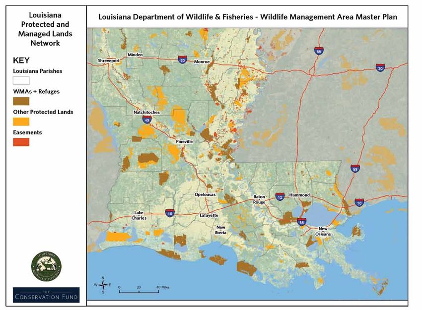
Master Plan for Wildlife Management Areas and Refuges - Louisiana Department of Wildlife and Fisheries
←
→
Page content transcription
If your browser does not render page correctly, please read the page content below
Louisiana Department of Wildlife and Fisheries
Master Plan for Wildlife Management
Areas and Refuges

                                             LANDSCAPE SCALE VISION AND OPPORTUNITIES   01
FOREWORD
My Friends –                                                as additional land and funding donations have and            ments that allow us to improve our WMA holdings and
                                                            continue to come forth, adding more properties to the        capacities. This WMA Strategic Master Plan is yet the
I am fortunate to follow predecessors that acted            Department’s Wildlife Management Area and Refuge             result of another cooperative endeavor with The Fund,
proactively on bequest of forward thinking staff            program. The WMA program was well received by the            helping us with an outside view of how we can move
to manage our great Wildlife Management Areas               hunters and fishers of our state, as these lands provided    our public land management program forward in a
(WMAs) and Refuge system. Those staff being the ones        quality wildlife recreational pursuits and opportunities     professional and proactive manner, while meeting the
entrusted by YOU, the citizens of our great state, to       for the sportsman. The land acquisition program also         wildlife resource needs and societal desires.
manage the tremendous wildlife resources associated         incorporated lease agreements with private and other
with the fields, prairies, sloughs, bayous, swamps          government land ownerships, enabling the Department          Our history has brought us to our current standing,
and forests across the state. At a time when land           to provide a wider variety of wildlife habitats for recre-   but we cannot rest, as much is still needed in certain
values were based primarily on their ability to grow        ational pursuits.                                            areas of the state to ensure a viable wildlife resource
agricultural crops, those managers knew inaction by                                                                      is sustained amidst the continuing draw on our natural
the Department would result in the continued loss and       As lands were acquired and/or enrolled in the WMA            resources from an ever expanding human dimension on
degradation of one of the nation’s greatest bottomland      program, personnel were hired to perform the manage-         the landscape. We must identify and prioritize issues
hardwood ecosystems; the Mississippi Alluvial Valley        ment tasks on these areas necessary to provide access        threatening our wildlife resources, develop appropri-
(MAV) bottomland forests. These forests were being          to the public and monitoring of activities allowed on the    ate mechanisms to thwart those threats, including fee
cleared extensively in that portion of the state to grow    WMAs. Hunting seasons and general rules and regula-          acquisition or conservation easement purchase of criti-
agricultural crops, providing the landowners with           tions were adopted by the Louisiana Wildlife and Fisher-     cal habitats, and continue to educate our public on the
a steady income flow they were not receiving from           ies Commission, based on recommendations of profes-          importance of our mission as the wildlife and fisheries
the forests on those lands. Over 80 percent of the          sional staff working on these WMAs and surrounding           agency of the great Sportsman’s Paradise.
bottomland hardwood forests in the MAV portion of our       private lands. Development plans were established for
state were cleared for agricultural production during       each WMA, based on the federal aid 5-year planning           Please, help us make it happen, for you and all of our
the middle of the 20th century. These clearings were a      cycle, providing staff and administration a continuing       future generations, Louisiana.
tremendous loss of important, quality wildlife habitat      forward- looking aspect of needs for sustaining the wild-
that is still impacting wildlife populations today.         life resources of these areas as well as the demands of
                                                            the public. The WMAs have become well known for the
My predecessors, working with Department staff and          quality of the habitats they represent and the tremen-
an overwhelmingly supportive state legislature, were        dous wildlife resources associated with these lands.
successful in utilizing Department funds to initiate an
aggressive land acquisition program, with an emphasis       Continued planning is necessary to maintain optimum
placed on acquiring remnant bottomland hardwood             use of these properties for our public. The Conserva-        Robert J. Barham
forest tracts within the Mississippi Alluvial Valley. The   tion Fund has been one of those private entities that        Secretary
forward thinking of these individuals also captured         continue to be strong partners with LDWF in securing
the interests of other conservation minded entities         lands for the WMAs and negotiating proactive agree-

                                                                                                                                                                                  i
acknowledgements

Financial support for this planning effort and publication   The Conservation Fund Planning Team
was provided by the United State Fish and Wildlife Service
                                                             Will Allen, Project Director, Master Plan Analysis
with additional funding provided by the State Wildlife
Habitat and Natural Heritage Trust Fund and the Louisiana    Ole Amundsen, Project Manager, Lead Plan Author
Department of Wildlife and Fisheries.                        Ray Herndon, Lower Mississippi Region Director,
                                                             Conservation Strategies and Implementation
Louisiana Department of Wildlife and Fisheries
                                                             Jazmin Varela, GIS Specialist
Office of Wildlife
Jimmy Anthony, Assistant Secretary                           Report Layout
Kenny Ribbeck, Chief of Wildlife Division
                                                             Jo Gravely, Freelance Photographer/Designer
Bob Love, Chief of Coastal & Non-Game Resources Division
Tommy Tuma, Biologist Director                               Report Design Team
Mike Carloss, Biologist Director                             Brian Phelps, Project Manager, Hawkins Partners
Amity Bass, Natural Heritage Program Manager                 Will Marth, Lead Design, Hawkins Partners
Nicole Lorenz, Natural Heritage Data Manager
Steve Smith, WMA Program Manager
Brad Mooney, GIS Coordinator                                 Report Citation
                                                                                                                  This public document was published at a total cost of $550.00.
                                                             Report citation: Louisiana Department of Wildlife    15 copies of this public document were published in the first
Office of Fisheries                                          and Fisheries and The Conservation Fund. 2014.       printing at a cost of $550.00. This document was published
Scott Longman, Biologist Administrator                                                                            by the Louisiana Department of Wildlife and Fisheries, 2000
                                                             Master Plan for Wildlife Management Areas and        Quail Drive, Baton Rouge, La. to provide information to the
Randy Myers, Boating Access Program Manager                  Refuges. Baton Rouge. 84 pages.                      public and staff of LDWF about the WMA and Refuge systems.
Becky Chapman, Public Information Officer                                                                         This material was printed in accordance with the standards for
                                                                                                                  printing by state agencies established pursuant to R.S. 43:31.
Enforcement Division                                                                                              Printing of this material was purchased in accordance with the
                                                                                                                  provisions of Title 43 of the Louisiana Revised Statutes.
Gabe Giffin, Information Section

 ii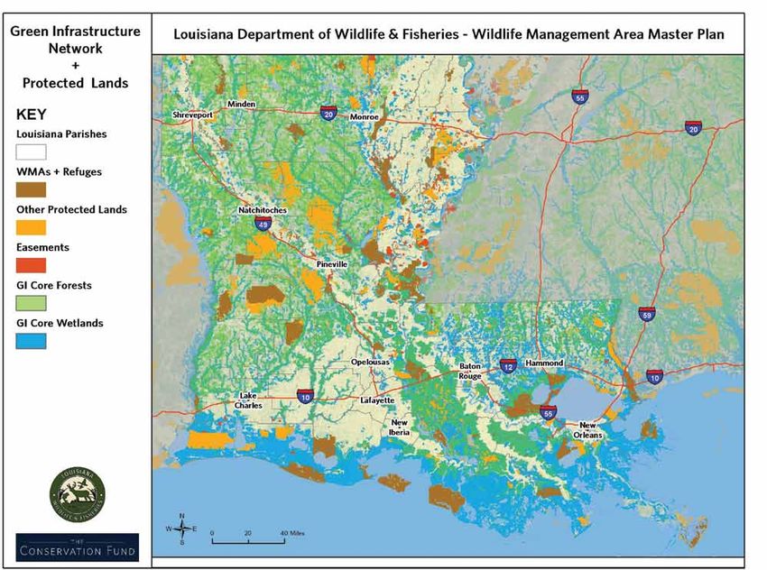
Contents

Executive Summary                           1
State of the State                          5
Landscape Scale Vision and Opportunities   17
Site Scale Vision and Opportunities        33
Conclusion                                 83

                                                iii
1   EXECUTIVE SUMMARY
1
Conservation plans make an
organization more efficient, able
to manage change and balance
competing needs.
                                    EXECUTIVE SUMMARY

                                    Both residents and visitors to Louisiana are attracted to   •   Provide the public, LDWF personnel, and key
                                    its wild places, abundant hunting and fishing opportu-          stakeholders with a useful reference document on
                                    nities and the biodiversity of the state. The challenge         important information and policies
                                    is to provide access to these special landscapes at an      •   Promote adaptive management through research
                                    adequate scale that facilitates public enjoyment without        and monitoring
                                    degrading natural resources for future generations. The
                                    Louisiana Department of Wildlife and Fisheries (LDWF)       Many compelling reasons exist for LDWF to craft a big
                                    manages a network of more than 1.6 million acres of         picture plan for its network of lands. Planning helps
                                    public lands. The purpose of this Master Plan is to guide   an organization become more responsive, nimble and
                                    LDWF’s landscape level management of this network of        proactive in its interactions with the public and conser-
                                    lands and to highlight opportunities for enhancing the      vation partners as well as in meeting management and
                                    network in the future.                                      funding challenges. In a 2010 national survey, the Land
                                                                                                Trust Alliance (the Alliance) found that conservation or-
                                    Goals for the Master Plan are to:                           ganizations that had conservation plans protected twice
                                                                                                as much land as organization without plans. A compel-
                                    •   Sustain a range of facilities and uses for the public   ling vision for the future can inspire the public to take
                                        to enjoy LDWF lands                                     action. Conservation plans make an organization more
                                    •   Provide a green infrastructure vision for LDWF to       efficient, able to manage change and balance compet-
                                        implement and manage landscape scale conserva-          ing needs.
                                        tion
                                                                                                In 2008, LDWF underwent a performance audit by the
                                    •   Identify focused restoration efforts to maximize        Legislative Auditor. The report found areas for improve-
                                        positive impact for ecosystems and leverage part-       ment in tracking acreage of LDWF lands, outlining land
                                        ner resources                                           acquisition processes and the need for a comprehensive
                                    •   Provide a comprehensive vision for landscape scale      plan to guide property management activities. The Mas-
                                        adaptive management for both LDWF lands and             ter Plan is one of several of LDWF’s long-term efforts to
                                        other partners                                          respond to the audit report and maintain strong bonds
                                                                                                of trust with the public.

 MASTER PLAN OF WILDLIFE MANAGEMENT AREAS AND REFUGES                                                                                                 2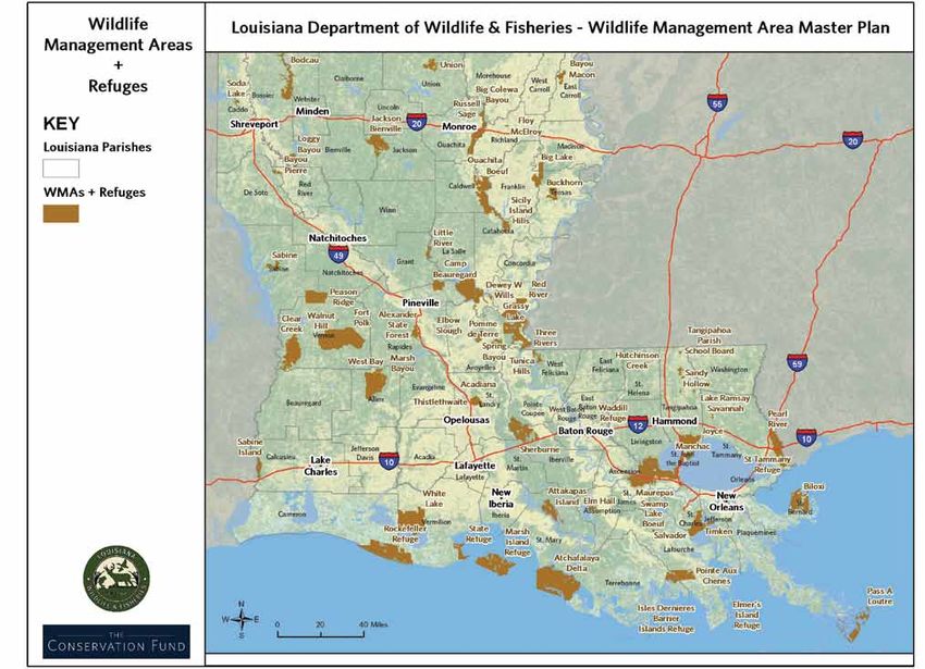
3 E xecutive S ummary
The Master Plan represents a landscape scale vision for
the future of LDWF. As part of the Master Plan a green
infrastructure network was developed to connect the
state’s wildlife management areas (WMAs) and refuge        LDWF Mission Statement
systems through a series of wildlife corridors.

The Master Plan links site level management plans for
                                                           To manage, conserve, and promote
                                                           wise utilization of Louisiana’s renewable
individual WMAs and organizational priorities reflected    fish and wildlife resources and their sup-
in the LDWF strategic plan. Like a site plan, the Mas-     porting habitats through replenishment,
ter Plan assesses the current resource management          protection, enhancement, research,
issues facing LDWF, examines the on-going efforts of       development, and education for the
LDWF and its partners, and examines gaps in the LDWF       social and economic benefit of cur-
portfolio of lands. Spatially, the Master Plan focuses     rent and future generations; to provide
on a proposed green infrastructure network designed        opportunities for knowledge of and use
to highlight future opportunities for conservation and     and enjoyment of these resources; and
corridors to connect LDWF lands together. The Master       to promote a safe and healthy environ-
Plan provides guidance on a land acquisition process for   ment for the users of the resources.
LDWF as well as how to strategically use other tools and
programs to implement LDWF’s statewide vision.

                                                                  E xecutive S ummary                   4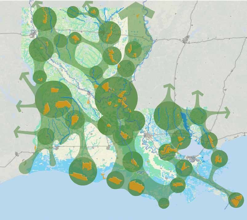
2   STATE OF THE STATE
5
STATE OF THE STATE
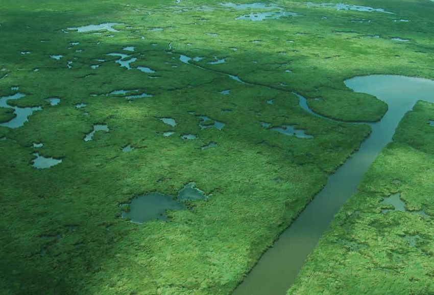
Louisiana offers residents and visitors a range of land- ment, building new land in the Mississippi and Atcha-
scapes from vast forests to remote barrier islands and falaya River deltas. Simultaneously, wave action from
immense wetlands systems. Within these landscapes hurricane storm surges and increased flooding from ris-
exist special places such as prime hunting spots, fishing ing sea levels erodes Louisiana’s coastline and wetlands
holes, birdwatching areas, and other sites that make at an alarming rate. Keeping this state of flux in mind,
Louisiana the “Sportsman’s Paradise.” The Louisiana acreage figures of public lands represent an important
Department of Wildlife and Fisheries (LDWF) Master story of public investment.
Plan’s green infrastructure network identifies the land-
scape level connections of these special places, in order Federal and state agencies own and manage roughly 3.3
to appropriately conserve and restore Louisiana’s rich million acres or 9.7 percent of Louisiana. LDWF’s wildlife
tapestry of ecological and recreational assets. management areas (WMAs) and refuges cover over 1.6
million acres or roughly 4.4 percent of the state. Other
To begin planning for the future, an understanding of state-owned lands, including State Parks, also contrib-
the current state of public lands in Louisiana and the ute to the inventory of public lands.
trends and threats at work within the state is critical.
Over the years substantial planning has occurred, and Federal agencies also are significant land stewards.
reviewing these plans helps identify work that LDWF The U.S. Fish and Wildlife Service (USFWS) manages an
can undertake as an agency and opportunities in which extensive series of refuges, covering over 600,000 acres.
it can collaborate as a partner. The United States Department of Agriculture’s (USDA)
Forest Service’s Kisatchie National Forest covers over
603,000 acres. The National Park Service (NPS), with
Public Lands in the Jean Lafitte National Park and other sites, manages
Louisiana close to 20,000 acres of public land. The United States
Army Corps of Engineers (USACE) and the Department
of Defense (DoD) both have extensive land holdings
Louisiana covers over 33 million acres and is home for within the state. Interestingly, many lands are leased
4.5 million residents. However, Louisiana is a dynamic by LDWF from USACE and DoD and are included in the
natural system, with an ever shifting balance between WMA and Refuge system.
what can be classified as land and what is considered as
open water. The state’s vast river systems deposit sedi-
MASTER PLAN OF WILDLIFE MANAGEMENT AREAS AND REFUGES 67 S tate of the S tate
In addition, several national and local nonprofit conser-    the fastest growing region of the state. The parishes
vation organizations operate in the state and protect        of Ascension, Livingston, St. Tammany and St. John
land by both fee acquisition and conservation ease-          the Baptist have experienced increases in population
ment, including The Nature Conservancy, Orleans Audu-        over the past decade and are forecast to continue this
bon Society, Coastal Land Trust, Coastal Plain Conser-       growth. The top parishes for growth through 2020 are
vancy, and the Land Trust for Southeastern Louisiana.        expected to be Livingston, St. Tammany, Ascension, St.
Ducks Unlimited, also known as America’s Wetlands            John, Plaquemines, Bossier, and DeSoto. These popula-
Trust, is a national nonprofit responsible for over 41,000   tion trends support LDWF’s aspirations to secure the         In planning for future use of LDWF
acres of easements.                                          assets currently managed and to expand its holdings,         lands, examining population trends
                                                             where feasible and appropriate, in order to serve the
                                                             state’s growing numbers.                                     provides guidance as to how LDWF may
Population trends                                                                                                         best serve the public interest. As of July
                                                             Population growth brings about many changes on the
In planning for future use of LDWF lands, examining          landscape level. According to the Louisiana State Wildlife
                                                                                                                          2011, the state’s population is estimated
population trends provides guidance as to how LDWF           Action Plan (SWAP) completed by LDWF in 2005, habitat        at 4,574,836, marking a 1.4 percent
may best serve the public interest. As of July 2011, the
state’s population is estimated at 4,574,836, marking
                                                             destruction, land conversion and fragmentation are           increase from the 2000 census. The U.S.
                                                             leading threats to ecosystems in Louisiana. The SWAP is
a 1.4 percent increase from the 2000 census. Over the        a statewide plan for the conservation of rare and declin-    Census Bureau forecasts that by 2020,
past decade, the impacts of hurricanes Katrina and Rita      ing species, and the habitats that support such species.     the state population will be 4,719,160 –
have caused swings in population at the parish level.        The SWAP identifies 317 Species of Greatest Conserva-
The U.S. Census Bureau forecasts that by 2020, the state     tion Need (SGCN), and provides information on the
                                                                                                                          a population increase of over 3 percent.
population will be 4,719,160 - a population increase of      threats to these species as well as conservation strate-
over 3 percent.                                              gies. The SWAP also provides detailed information on 38
                                                             terrestrial habitats, 12 aquatic basins, and five marine
Overall, Louisiana’s population appears to be shifting       habitats that are critical to the conservation of SGCN,
from rural areas to metropolitan regions. An estimated       and strategies to protect and conserve such habitats. As
70 percent inhabit urban or suburban areas. Accord-          causes of these threats, the SWAP lists residential devel-
ing to analysis by Dr. Troy Blanchard of Louisiana State     opment, commercial/industrial development, conver-
University, southern Louisiana will continue to be

                                                                                                                                      S tate of the S tate         8
sion to agriculture or other forest type, and the develop- to LDWF efforts to capitalize on tourism. Texas is the
ment of infrastructure such as pipelines and roads. largest source of tourists visiting Louisiana, accounting
for 25 percent of all visitors. The Texas cities of Houston
As highlighted in the SWAP, many parishes in the Upper and Dallas/Ft. Worth are the leading cities for visitors
West Gulf Coast Plain and northern portions of the Mis- to Louisiana. Mississippi and Florida are also significant
sissippi River Alluvial Plain are declining in population. sources of visitors to Louisiana accounting for 6 percent
The top parishes forecast to experience population loss each of tourists to the state. By studying the reasons
through 2020 include: Madison, Tensas, East Carroll, that draw residents of Texas to Louisiana, LDWF can The Texas cities of Houston and Dallas/
Winn, Concordia, Vernon, and Catahoula. maximize its existing strengths with this market. Ft. Worth are the leading cities for visi-
In addition, projections indicate that the state’s popu- Trends among user groups of LDWF WMAs and refuges tors to Louisiana. Mississippi and Florida
lation is growing older with a 5 percent increase in are factors to consider in planning for state lands. Ac- are also significant sources of visitors to
the state’s retirement age portion of the population. cording to the Outdoor Industry Foundation, Louisiana’s
Estimates show that 17.6 percent of the population active outdoor recreational economy contributed more
Louisiana accounting for 6 percent each
will be composed of persons 65 years of age or older than $4.7 billion to the state’s economy, generating over of tourists to the state. By studying the
by 2030. Therefore, LDWF must anticipate this demand $225 million in state tax revenue and supporting 48,000 reasons that draw residents of Texas to
for facilities designed with an aging population in mind. jobs.
Improved access for wheelchairs for bathrooms, board- Louisiana, LDWF can maximize its exist-
walks, shooting ranges and visitor centers are examples In surveys conducted for the Louisiana Statewide Com- ing strengths with this market.
of the needs of an older population. prehensive Outdoor Recreation Plan (SCORP), the most
important recreational activities were fishing, crabbing
and crawfishing, with 62 percent of residents participat-
Tourism and Outdoor ing in these activities. Other important activities were
Recreation Trends walking-hiking, camping, public access to water, and
hunting. These results suggest that LDWF efforts to
improve and maintain access to waterways are broadly
Louisiana is a significant tourist destination. Under- supported by the public. Facilities for camping are
standing the sources of visitors to Louisiana is critical popular with the public. However, if LDWF embraces
9 S tate of the S tatethis priority, additional resources would be required to more Texas visitors to engage in wildlife viewing experi-
maintain those facilities to meet public expectations ences not available within their own state.
for campgrounds with modest services. According to
the SCORP, trends in travel indicate that shorter, more
frequent weekend trips for recreation are more popular Lifestyle Trends
than longer season vacations. If this trend holds, it may
mean that more of the state’s recreational tourism will The national trends of increased obesity and a seden-
be from within the state or from the nearby states of tary lifestyles are strongly observed in Louisiana. For
Alabama, Arkansas, Texas, Florida and Mississippi. example, in 1990, roughly 12.3 percent of the state’s
population was considered to be obese, where as in
Hunting and fishing are extremely important activities 2011, 31.7 percent were classified as obese. Nationally,
on LDWF WMAs across the state and are central to the watching TV is the top after school activity chosen by
mission of LDWF. In 2014, the LDWF licensing section all children ages 8 to 18. In a recent Centers for Disease
processed over 2.4 million transactions for an estimated Control survey, 70 percent of children in Louisiana have
800,000 customers. Individuals may hold multiple li- a TV in their bedroom. According to the Bureau of Labor
censes, and the figures reflect transactions by residents Statistics, Louisiana ranked second in the country for
and nonresidents. The number of hunters, anglers and watching the most television at three and a half hours
wildlife viewers fluctuates each year depending upon per day. According to the United Health Foundation,
a wide range of variables such as the health of the Louisiana ranked 49th in the country in overall health.
economy, weather events, and lifestyle trends. One of the factors in the Foundation’s ranking was
physical activity; adults were asked if they had partici-
As hunting and fishing licenses are a major revenue pated in any physical activity at some point within a 30-
source for LDWF, there is a need to monitor trends day period. Based on the responses, Louisiana ranked
among LDWF’s key user groups. Increasing the diver- 47th in the country. These national trends have major
sity of funding sources for LDWF is a sound strategy to implications for the future of public health of Louisiana
provide stable funding. Exploring new fee structures for residents and the use of LDWF lands.
different user groups such as bird watchers, expanding
hunter education programs to bring new people into
the sport, and supporting environmental education to Invasive Species
secure general public awareness are all solid methods
for securing a promising future. Ecosystems have evolved over thousands of years, with
plants and animals finding distinct niches in often harsh
One of the key assets of Louisiana is its abundant landscapes. The introduction, both intentional and
birdlife. Louisiana attracts more than half of the birds of unintentional, of exotic species of plants and animals
America either as permanent residents or as migrants upsets this careful, complex and subtle balance that has
been worked out on the landscape for centuries. Most
in the Mississippi and Central flyways, according to a
2004 study by the ecotourism firm FERMATA in assess- importantly, invasive species threaten to displace native One of the key assets of Louisiana is
species, which are often a central motivation for the its abundant birdlife. Louisiana attracts
ing opportunities for a state birding trail. This dramatic
conservation of protected lands. more than half of the birds of America
occurrence draws both bird watchers and hunters to
either as permanent residents or as
Louisiana. One of the most insightful recommendations
According to the Louisiana State Wildlife Action Plan, migrants in the Mississippi and Central
from the FERMATA report was to focus on attracting
there are over 230 invasive plant and animal species in flyways.
S tate of the S tate 10the state. Invasive species are broken into four tiers, with document”, in that it will evolve over time to mirror the
Tier 1 species being the most problematic. Tier 1 species changing conservation landscape in Louisiana. There-
are those that experience severe or widespread nega- fore, the SWAP must be revised every 10 years, at a
tive impacts to wildlife and natural communities. They minimum. LDWF, with input from partners, is currently
include species such as feral hogs, giant salvinia, Chinese working on the first comprehensive review and revision
tallow, and the red imported fire ant. The SWAP provides of the SWAP, which will be completed in 2015.
strategies to deal with invasive species in the state. Pub-
lic land stewards should address any invasive issues on
their properties to reduce natural resource damage. Coastal Land Loss
The purpose of the Louisiana Comprehensive Wildlife According to the Coastal Protection and Restoration
Conservation Strategy (2005), referred to in this report Authority, Louisiana has lost over 1,883 square miles
as the Louisiana State Wildlife Action Plan (SWAP), was of land since the 1930s. If dramatic action is not taken,
to provide LDWF and other conservation groups with the state could lose an additional 1,756 square miles
a strategy for the conservation and management of of land over the next 50 years. Complex factors are at
Louisiana’s fish and wildlife resources, with an emphasis work behind these changes, which are attributed to sea
on species of conservation concern and associated habi- level rise, coastal subsidence, and damage by storm
tats. By promoting proactive conservation, the SWAP is events. By the year 2100, ocean levels could be 24 to 47
intended to reduce the need for future listings under inches higher than today, based on a continued average
the Endangered Species Act. There are four primary subsidence rate of 8 to 31 inches per century and mid-
goals of the SWAP, all of which are closely related to the range sea level rise model estimates. State and federal
LDWF Master Plan. The first goal of the SWAP is Species governments have launched ambitious efforts to restore
Conservation, which is directly tied to the Master Plan, coastal barrier islands, replenish coastal areas with sedi-
as LDWF properties are and will continue to be criti- ment, and restore marshlands. LDWF plays a vital role
cal to maintaining healthy populations of all species of in the planning of such coastal restoration projects on
wildlife in Louisiana. The second goal of the SWAP is properties it owns and or manages.
Habitat Conservation, which is also clearly connected to
the Master Plan, as LDWF properties often provide the LDWF’s vast network of coastal WMAs and refuges is
best and most reliable opportunities to achieve large- directly impacted by changing sea level and increased
scale habitat management and conservation. Public flood events. As LDWF assesses areas to invest resourc-
Outreach and Education, the third goal of the SWAP, es, understanding the future impacts of changes in sea
cannot and will not be achieved without the opportu- level and the degree of land loss may help inform those
nities for conservation education provided by LDWF discussions.
WMAs, as these areas often provide the public with
their best access to natural systems, thereby increas-
ing public appreciation and support for conservation. Past Planning Efforts
Finally, the fourth goal of the SWAP, Partnerships, is
clearly linked with the Master Plan, as some of LDWF’s The state of Louisiana has benefited from many plan-
WMAs are made available via such partnerships, ning efforts over the years. Over 40 regional and state-
thereby increasing opportunities for both conservation wide plans were reviewed and assessed for relevance to
and public access. The SWAP is intended to be a “living this Master Plan. Brief summaries of the LDWF Strategic
Plan and the SWAP and other agency plans are provided
11 S tate of the S tateFigure 1
Predicted land change along the Loui-
siana coast over the next 50 years if we
do nothing more than we have done
to date. Red indicates areas likely to be
lost, and green indicates areas of new
land. This map is based on assumptions
about increases in sea level rise, sub-
Map provided by:
sidence, and other factors. (Estimate Coastal Protection and Restoration Authority of Louisiana. 2012.
based on less optimistic scenario of Louisiana’s Comprehensive Master Plan for a Sustainable Coast. Coastal
future coastal conditions.) Protection and Restoration Authority of Louisiana. Baton Rouge, LA.
S tate of the S tate 12Figure 2
This figure shows generalized estimates
of flood depths for a 100 year flood 50
years from now, once the landscape
has degraded and with no additional
flood protection. These flood depths
represent a broad planning level
evaluation of overall flooding risk. This
map is based on assumptions about
increases in sea level rise, subsidence,
Map provided by:
and other factors. (Estimate based
Coastal Protection and Restoration Authority of Louisiana. 2012.
on less optimistic scenario of future Louisiana’s Comprehensive Master Plan for a Sustainable Coast. Coastal
coastal conditions.) Protection and Restoration Authority of Louisiana. Baton Rouge, LA.
13 S tate of the S tatealong with how the Master Plan relates and imple- is that green infrastructure networks frequently provide private and public lands, and provide valuable informa-
ments portions of these planning efforts. The expansive opportunities for outdoor recreation for the public tion on how management of WMAs and other LDWF
nature of the LDWF Master Plan is such that many of and help support viable populations of game species. properties can provide maximum benefits to SGCN. The
the recommendations of other planning efforts can be Through the thoughtful implementation of the green importance of such public lands to the conservation of
achieved through the implementation of the Master infrastructure network, LDWF can make strong progress SGCN will become even more pronounced in the future,
Plan. Identifying areas of collaboration among govern- on the delisting of federally listed species, as the net- as development pressure increases on private lands.
ment, nonprofit, academic and other partners is critical work will provide protected and managed habitat and
for the full implementation of the LDWF Master Plan. will help focus habitat restoration efforts. The overarching framework of the Master Plan focuses
strongly on management and protection of viable ter-
The strategic plan for LDWF established several goals, The LDWF strategic plan objective of sustaining an aver- restrial and aquatic habitats for a wide range of species.
activities, and objectives that can be facilitated through age of 800,000 annual users of the WMA and Refuge A comprehensive green infrastructure network is a
the Master Plan. The overall goal for the Wildlife Pro- system is supported by efforts articulated in the LDWF sound approach to preserve a diverse and rich ecosys-
gram is to enhance and conserve the habitat necessary Master Plan. Users have an impact on the network of tem and minimize future listings of species under the
to maintain the state’s species diversity and optimum LDWF lands, and only through wise planning can these Endangered Species Act. Many of the opportunities for
distribution and densities of wildlife populations, and impacts be addressed. Hunting license fees and other conservation identified in the green infrastructure net-
to increase the opportunities for the public to enjoy user fees are the key source of LDWF revenue, so keep- work will be sites that are appropriate for management
outdoor experiences including hunting and fishing. ing user groups interested in the LDWF network of pub- and restoration of listed species as well as sites that
LDWF tracks rare, threatened and endangered species lic lands is also vital. Balancing public use with natural are in prime condition and require protection through
and habitats as one method of measuring conservation resource management is the nexus of sustainability and acquisition or other mechanisms. Although many of
success or to identify areas that need improvement. is at the heart of the vision established by the Master the species of concern used in the green infrastructure
Plan as well as an objective of the LDWF strategic plan. network are federally listed species, there are a signifi-
The green infrastructure network crafted within the cant number of non-listed species that have been used
Master Plan supports the goals of the LDWF strate- The SWAP is intended to provide guidance to both to create the network design, including state species of
gic plan by articulating an interconnected system of LDWF and other conservation organizations throughout concern.
protected lands that provides habitat for both federally the state on how best to direct conservation dollars
listed species as well as other non-listed wildlife. By and effort to benefit rare and declining species. This The green infrastructure network developed for the
examining several different habitat and landscape types, proactive approach to conservation is intended to limit LDWF Master Plan highlights advantages of connecting
the green infrastructure network will assist LDWF in future Endangered Species Act listings. The goals and the state’s WMA and Refuge system through wildlife cor-
conserving the biodiversity of the state. Another benefit strategies detailed in the SWAP can be applied to both ridors. The success of the restoration efforts proposed
A nother planning effort that warrants attention is the Comprehensive Master Plan for a Sustainable Coast. After Hurricanes Katrina and Rita,
the Louisiana Legislature created the Coastal Protection and Restoration Authority (the Authority) in 2005 and required that this new agency
develop a plan for a safe and sustainable coast. In 2007 the Authority released its first Master Plan highlighting many land protection and res-
toration projects. In January 2012 the Authority released an updated draft plan for the coast with a 50-year time horizon. Based on the latest
research and models, the projects endorsed by this draft plan may, over 30 years, reverse the level of land loss to coastal erosion to actual
land gain. In the final analysis, 145 projects were proposed in the Master Plan ranging from restoration to structural protection.
S tate of the S tate 14within the Master Plan for a Sustainable Coast will have by the forest products companies and Timber Invest- ation was applied to coastal forest as well as landforms
a significant impact on the success of LDWF planning ment Management Organizations (TIMOs). Linking the such as cheniers and natural levees that serve as
efforts. In addition, the green infrastructure network forest lands of Louisiana with Texas would help improve protection and allow for the coast to be more resilient
identifies areas for conservation of inland wetlands and the long term viability of wildlife corridors. Second, the from hurricanes. The LDWF Master Plan’s emphasis on
riparian areas that will improve the disaster resistance Upper Louisiana Delta highlights 10 parishes from the coastal ecosystems, corridors and conserving chenier
of Louisiana to storm events. Wetlands and riparian Arkansas border down to Avoyelles Parish. This region ridges is a shared priority. Chenier restoration is a prior-
floodplain areas often serve as storage areas for flood has been the focus of partnership efforts to conserve ity for both LDWF and the Gulf Coast Prairies Landscape
waters. If these flood prone lands are developed, the forested habitat, promote corridors for the Louisiana Conservation Cooperative.
water that would have been stored is moved more rap- black bear, and restore bottomland hardwoods ecosys-
idly downstream, increasing the severity of flood dam- tems. State plans for tourism were examined for the LDWF
age as well as increasing the pace of the flood event. A Master Plan. The Department of Culture, Recreation
green infrastructure network that conserves wetlands In the revised Louisiana State Wildlife Action Plan and Tourism commissioned two reports by FERMATA
and aquatic areas will help store floodwaters and slow (SWAP), which will be completed in 2015, Conservation on the viability of coastal and inland birding trails as an
the pace of flood events in the downstream areas. Opportunity Areas (COAs) will be identified through- approach to diversify tourism, educate the public on
out the state. These COAs will be specific areas where the outdoors, and promote conservation. The core of
The 2010 Louisiana Statewide Forest Resource Assess- conservation dollars and effort can be concentrated to these two reports offers a detailed assessment of major
ment and Strategy, more commonly known as a Forest provide the most benefit to SGCN and their habitats. birding trail routes and an inventory of existing facilities
Action Plan (FAP), analyzed forest conditions and trends Many factors will be considered in the process of identi- including WMAs. A total of 24 WMAs and the Booker
across the state and incorporated three overarching na- fying COAs, including: Fowler Fish Hatchery were recommended as significant
tional priorities: conserving working forest landscapes, • Occurrence of S1, S2, and S3 species. sites along the bird trails.
protecting forests from threats, and enhancing public • Occurrence of S1 natural communities.
benefits from trees and forests. • Location of Critical Habitat for Federally listed spe-
cies. LDWF Master Plan
The FAP features a map of eco-cultural regions and
priority areas that overlays nicely with many of the
• Presence of existing conservation lands (including
WMAs). Goals
landscape level priorities of LDWF. The Florida Parish • Opportunities for wildlife corridors.
priority area is eligible for Forest Legacy funding and • Projected development and population growth. Based on an analysis of a wide range of state and
reflects six of the eight state level issues, including suit- regional plans, surveys and meetings with LDWF staff,
ability for longleaf pine regeneration and the likelihood Once identified, COAs will help LDWF and other con- the following goals have emerged for the Master Plan.
of increased pressure from suburban development. servation groups in prioritizing habitat management, Many of these goals were produced by other govern-
LDWF has a natural interest in partnership within this habitat protection, and land acquisition. ment planning efforts as noted. However, these goals
region regarding longleaf pine as a prime habitat for present an opportunity for collaboration.
the red-cockaded woodpecker (RCW) and the gopher The Coastal and Estuarine Land Conservation Program
tortoise. Providing increased access to outdoor recre- Plan (CELCP) evaluates land conservation opportunities Sustain a range of facilities and uses for the public to
ation and hunting and fishing for nearby populations in order to aid efforts to protect and conserve habitats enjoy LDWF lands
would also be a shared priority between LDWF Master that provide environmental, historical, aesthetic, and • Maintain an annual average of 800,000 users of the
Plan and FAP. recreational benefits for the public. Wetlands, shore- WMA and Refuge system (LDWF strategic plan)
lines, and adjacent uplands are listed as CELCP priority • Incorporate American Wetland Birding Trail list
The FAP also highlights two other priority areas. First, areas. Important ecological aspects of these priority of WMAs into evaluation of funding priorities for
the Terrace Flatwoods region of central and western areas are biotic production, corridors/connectivity and/ WMA infrastructure improvements such as parking
Louisiana draw attention to the longleaf pine ecosystem or core conservation areas, migrating bird habitat, and facilities, nature trails, boardwalks and observation
and overlaps with significant WMAs and lands owned landscape processes and functions. Special consider- platforms
15 S tate of the S tateProvide a green infrastructure vision for LDWF to Identify focused restoration efforts to maximize impact
implement and manage landscape scale conservation for ecosystems and leveraging partner resources
• Expand LDWF holdings by 5,000 acres per year (Vi- • Promote increased acreage and natural manage-
sion 2020 + other plans) ment of longleaf pine
• Accelerate acquisition of wetlands and grasslands • Restore wetlands and chenier ridges
from private landowners in the prairie region • Rebuild barrier islands and ridges. (Master Plan of
• Identify Important Bird Areas (IBAs) and partner Coastal Protection and Restoration Authority)
with appropriate organizations to implement con- • Sustain a diversity of coastal habitats including cy-
servation strategies press swamps, marshes, ridges, and barrier islands
• Continue efforts to support the conservation of (Master Plan of Coastal Protection and Restoration
remaining migratory bird habitat Authority)
• Investigate potential land acquisitions for habitat • Restore bottomland hardwood forest restoration as
for rare, threatened and endangered species per Forest Breeding Bird Decision Support Model
• Continue to work with U.S. Fish and Wildlife Service • Pursue tactical acquisition of available coastal
(USFWS) and other partners to implement the prairie
recovery plan for all threatened and endangered
species
• Work with landowners and other partners to initi-
ate or continue the implementation of Partners
In Flight (PIF) bird conservation plans, conserva-
tion plans developed for amphibians and reptiles,
and federally endangered and threatened species
recovery plans
• Work with organizations such as Ducks Unlimited
(DU), National Wild Turkey Federation (NWTF),
The Conservation Fund (the Fund), and USFWS
to assure quality habitat distribution across the
landscape
Provide the public, LDWF personnel, and key stake-
holders with useful reference documents on important
information and policies
• Provide accurate acreage for LDWF owned and
managed lands
• Provide a template to guide site management plans
• Provide summary/outline of land acquisition pro-
cess and project selection criteria as reference for
agency staff, partners, and the public
S tate of the S tate 163 LANDSCAPE SCALE VISION AND OPPORTUNITIES 17
Green infrastructure planning
reaches beyond an individual
parcel or park scale. It is the big
picture vision for a region or state.
                                        LANDSCAPE SCALE VISION AND OPPORTUNITIES

                                        One of the primary goals of the Louisiana Department         Green infrastructure has become a popular term,
                                        of Wildlife Fisheries (LDWF) Master Plan is to identify      referring to everything from green roofs to ecologically
                                        and assess future land acquisition and restoration op-       friendly stormwater management systems and large
                                        portunities. This section examines opportunities beyond      networks of natural areas. What these different usages
                                        the individual wildlife management area (WMA) or par-        have in common is the basic recognition that our built
                                        cel level, focusing instead on large, statewide or multi-    environment and our ecological environment are con-
                                        parish scale acquisitions and restoration opportunities.     nected and strongly interrelated. For the context of this
                                                                                                     project, our definition of green infrastructure is at the
                                                                                                     landscape scale - illustrating an ecologically-based net-
                                        What is Green                                                work of public and private lands. Green infrastructure
                                        Infrastructure?                                              planning reaches beyond an individual parcel or park
                                                                                                     scale. It is the big picture vision for a region or state.
                                        Just as communities must direct strategic development        The green infrastructure network consists of core areas,
                                        to maintain and enhance quality of life, communi-            corridors, and hubs that provide essential habitat to
                                        ties also need strategic conservation to accommodate         endangered and threatened species as well as other
                                        development while maintaining a healthy environment.         important species that link to broader natural functions
                                        The infrastructure that sustains a community is both         and processes at the ecosystem scale. Core areas contain
                                        built (e.g., roads, utilities) and natural (e.g., drinking   well‐functioning natural ecosystems and provide high‐
                                        water, clean air, forests).                                  quality habitat for native plants and animals that meet a
                                                                                                     minimum size threshold based on landscape conditions.
                                        A green infrastructure network is an interconnected          These are the nuclei of the green infrastructure network.
                                        system of natural areas and open spaces that conserves
                                        ecosystem values, helps sustain clean air and water, and     Corridors are linear features that link core areas in
                                        provides benefits to people and wildlife. Once designed,     order to allow animal and plant propagule movement
                                        a green infrastructure network provides a framework          between them with the goal of creating viable and
                                        that can be used to guide future growth and land             persistent metapopulations. Often these corridors can
                                        conservation decisions to accommodate population             be used for passive recreation such as hiking and biking,
                                        growth while preserving community assets and natural         and when combined with water corridors offer oppor-
                                        resources.

   MASTER PLAN OF WILDLIFE MANAGEMENT AREAS AND REFUGES                                                                                                     18
19 LANDSCAPE SCALE VISION AND OPPORTUNITIES
tunities for canoeing, rafting, and fishing. In creating   as forest interior dwelling birds, whose habitat needs        We believe that green infrastructure provides equal
corridors, the landscape between core areas is assessed    overlap those of other animals and plants. Keystone           value to communities and requires the same level of
for its linkage potential, and conduits and barriers to    species are those with an important role in ecosystem         attention, care and concern.
wildlife and seed movement are identified.                 function, such as pollinators and top carnivores. Habitat
                                                           preferences of umbrella and keystone species help             The LDWF Green Infrastructure Network is a central tool
Hubs provide breathing room for plants and animals,        identify core areas and hubs. Connectivity requirements       to aid LDWF staff in assessing the landscape opportuni-
ecosystems and people. Hubs are aggregations of core       of less vagile (i.e., mobile) species (e.g., amphibians and   ties. It is a statewide green infrastructure network most
areas, other habitat, and other natural land divided by    small mammals) are used to model corridors. When              recently updated in 2010. A brief summary of develop-
major roads or gaps and meet a minimum size thresh-        sufficient habitat is protected to sustain umbrella and       ment of the network is provided.
old based on landscape conditions. Hubs are intended       keystone species, other important components and
to be large enough to support populations of native        microhabitats are encompassed and are more likely to          In 2008, The Conservation Fund (the Fund) received a
species, serve as sources for emigration into the sur-     be protected as well.                                         Section 6 Cooperative Endangered Species Conservation
rounding landscape, and link areas outside the extent of                                                                 Fund grant entitled: “Determining Mitigation Needs for
the analysis area for a particular project.                Gray infrastructure refers to traditional man-made            NiSource Natural Gas Transmission Facilities - Imple-
                                                           structures, such as roads, railways, airports and sewers      mentation of the Multi-Species Habitat Conservation
Umbrella and keystone species native to an area            that bind a community together and help improve the           Plan (MSHCP).” As part of this planning effort, the Fund
are used to determine size, connectivity, and other        efficiency of our economy. This infrastructure is planned     created a 13-state green infrastructure network to help
thresholds in the green infrastructure network design.     and maintained, and is considered to be a basic neces-        find the best locations for mitigation for impacts to fed-
Umbrella species are a species or group of species, such   sity and a necessary investment in our collective future.     erally listed species as part of the NiSource MSHCP.

                                    Partial list of 40 major plans reviewed by the Fund of some of the major plans reviewed
    •   Performance Audit of the Louisiana Department of Wildlife and Fisheries           •    Open Pine Landbird Plan West Gulf Coastal Plain/Ouachitas, 2010
        Office of Wildlife (2008)
                                                                                          •    Southeast United States Regional Waterbird Conservation Plan, 2006
    •   Louisiana: Vision 2020 Master Plan for Economic Development (1999)
                                                                                          •    Gulf Coast Joint Venture: Chenier Plain Initiative, 2001
    •   Louisiana Department of Wildlife and Fisheries Strategic Plan 2011-12
        through 2015-16 (2010)                                                            •    Gulf Coast Joint Venture: Mississippi River Coastal Wetlands Initiative,
                                                                                               2002
    •   Louisiana Comprehensive Wildlife Conservation Strategy (CWCS) (2006)
                                                                                          •    Forest Legacy Assessment of Need (2005)
    •   Concept and Development Plan: America’s Wetland Birding Trail: Red
        River Leg, Mississippi River Leg and Zachary Taylor Parkway Leg (2007)            •    Louisiana Statewide Forest Resource Assessment and Strategy, 2010

    •   Concept and Development Plan: America’s Wetland Birding Trail – Along             •    Coastal Impact Assistance Program Plan, 2009
        Louisiana’s Great Gulf Coast (2004)
                                                                                          •    State of Louisiana Coastal and Estuarine Land Conservation Program
    •   Louisiana State Comprehensive Outdoor Recreation Plan (SCORP), 2009                    Plan (CELCP) May 2011

    •   Restoration, Management, and Monitoring of Forest Resources in the                •    Louisiana Comprehensive Master Plan for a Sustainable Coast, Draft
        Mississippi Alluvial Valley: Recommendations for Enhancing Wildlife                    January 2012
        Habitat by the Lower Mississippi Joint Venture, 2007

                                                                                                LANDSCAPE SCALE VISION AND OPPORTUNITIES                                       20
During the fall of 2008, the Fund convened a focus outlined green infrastructure network elements (e.g.,
group meeting in Louisiana to begin reviewing the core forests, core wetlands, hubs, and corridors).
design of the green infrastructure network. Following
a short presentation on the green infrastructure design Starting in the spring of 2010, the Fund staff modeled
method, the Fund staff distributed a six‐page feedback core areas, hubs, and corridors of the green infrastruc-
form to solicit information on current species distribu- ture network. The wetland core areas portion was
tion, current research and fieldwork, and species that completed in May 2010, and associated wetland cor-
were no longer present within the state. Participants ridors were delineated in August 2010. Staff relied on The LDWF Green Infrastructure Network
were also asked to comment on umbrella and keystone the National Land Cover Database’s wetland classes, as is a central tool to aid LDWF staff in
species criteria, and thresholds for core areas for forest this was the only data consistently available across all
and wetlands. Similar questions were listed for feedback 13 states. Based on peer‐reviewed literature on habitat assessing the landscape opportunities. It is
on assumptions for the delineation of wildlife corridors. needs of focal species, wetlands greater than or equal a statewide green infrastructure network
Next, participants were asked to review a GIS data qual- to 370 acres (150 hectares) were selected as core wet-
ity assessment report and a bibliography of state plan- land areas. Wetland connectors were manually identi-
most recently updated in 2010.
ning documents. Participants were asked to add missing fied using National Hydrographic Data (NHD) in three
GIS layers or planning documents that were in develop- NHD regions (2, 5 and 6). Staff added the stream valleys
ment so that these products could be incorporated into and riparian cover along these connector streams to
the MSHCP green infrastructure network design. The identify wetland corridors.
Fund transcribed and analyzed the input provided at the
state focus group meetings. Modeling work on the forest core areas began in March
2010 and was completed in September 2010 for the
During this period, the Fund staff continued to contact 13‐state study area. The Fund used the “National Green
individual focus group participants to obtain addi- Infrastructure Assessment” developed by the United
tional GIS layers, scientific literature, or clarification of States Environmental Protection Agency (EPA). This as-
comments made on the input forms. The draft green sessment uses a morphological spatial pattern analysis
infrastructure network design protocol document, com- (MSPA) to identify hubs and links.
pleted in 2009, defined scales, established criteria and
thresholds, identified keystone/umbrella species, and
© Sean Gardner © Sean Gardner
21 LANDSCAPE SCALE VISION AND OPPORTUNITIESNext, the Fund examined the peer reviewed literature as a key element to be used in developing Master Plan
on umbrella/keystone species, and with feedback from recommendations. In February 2012, the Fund staff met
state officials, created a matrix of focal species with with field staff across Louisiana, providing an orienta-
acreage thresholds matched to both state boundar- tion to the project and the green infrastructure network
ies and ecoregions. By using ecoregional boundaries, design. Surveys on field staff priorities and site manage-
the Fund was able to cross reference each ecoregion ment challenges were reviewed. Acquisition opportuni-
to a suite of focal species and consequentially to a size ties and improvements to facilities were discussed. Over
threshold needed to sustain a viable population of 40 national, regional and state-level planning studies
those species. These thresholds indicate the minimum were reviewed by the Fund to assess long-term trends
forest acreage that can accommodate the needs of to key natural resources and opportunities for collabora-
many forest‐dependent species. A caveat on the inter- tive implementation of the Master Plan.
pretation of focal species thresholds is that this method
is an attempt to broadly characterize a landscape; it In March, the Fund staff met with LDWF headquarters
© Tim Lenz
does not state that these species actually occupy these staff to review the information collected, assess the
forest core areas. Focal species thresholds are broad priorities to be addressed within the Master Plan, and
indicators, providing general clues as to ecoregional
habitat quality and viability. For Louisiana, more than
to ascertain the level of policy issues to be elaborated
upon within the document. GIS analysis of the distri-
The U.S. Fish and Wildlife Service and
NiSource have embarked upon a
37 species were utilized as umbrella and/or keystone bution of species of concern and other resources was
Multi-Species Habitat Conservation
species, including the Louisiana black bear, river otter, conducted and reviewed by LDWF.
Plan (MSHCP) that, when completed,
cerulean warbler, red-cockaded woodpecker, king rail,
will allow NiSource to operate under a
Bachman’s sparrow, mole salamander, and wild turkey. The green infrastructure network covers over 16 million
single, consolidated permit for the next
acres - an impressive 48 percent of Louisiana. The vision
50 years.
In September 2010, the Fund began using a least cost map illustrates the major core areas both as they relate
path model to identify optimal connections between to LDWF lands and new opportunities. Major corridors
The MSHCP’s unprecedented scope —
core forest areas, preferring intervening forest and for wildlife and recreation are illustrated as general
geographically, over 6.4 million acres;
avoiding urban areas and roads. Forest corridors were concepts, capturing the overall flow and connectivity of
duration, 50 years; number of species,
at least 656 feet (200 meters) wide, based on interior the network.
75 federally listed — took NiSource and
forest bird requirements and a study that showed that
the USFWS to The Conservation Fund.
corridors greater than 656 feet (200 meters) wide gen-
They sought the Fund’s assistance
erally had less than 10 percent exotic invasive plants. A
in determining the best locations for
width of 984 feet (300 meters) was preferable. Concur-
mitigation using its strategic conserva-
rent to the analysis on core areas, the Fund modeled
tion assessment and planning expertise
hubs for the overall green infrastructure network. As
and its conservation leadership ser-
hubs provide a protective buffer around core areas, a
vices for convening stakeholder groups
critical step in creating hubs was to sufficiently buffer
throughout the affected states. When
the core forest and wetlands to include edge transitions
the MSHCP is issued, NiSource mitiga-
and protection from disturbances and pollution.
tion dollars will leverage both state and
federal conservation funds and provide
In 2011, LDWF invited the Fund to craft a Master Plan for
significant conservation benefits.
the WMA and Refuge system, with the green infrastruc-
ture network serving as both the cooperative match for
the partnership between LDWF and the Fund as well
LANDSCAPE SCALE VISION AND OPPORTUNITIES 2223 LANDSCAPE SCALE VISION AND OPPORTUNITIES
Tactical Acquisitions
A significant number of the LDWF’s WMAs is leased
from other government agencies and private landown-
ers. While the public use and LDWF’s management prac-
tices of these leased lands often make these non-state
owned WMAs indistinguishable from areas currently             Many of the leased WMAs are owned
owned by the state, the leased areas may be subject to
future change of ownership and/or lease agreements.           by forest products companies or TIMOs.
                                                              These lands can be sold at any time to
LDWF maintains several WMAs on active military bases,
USACE lands and USDA Forest Service lands. While              another private owner that may not
these federal landowners are the most stable partners         possess the same stewardship ethic or
for joint management, the possibility does exist that
these lands may be no longer needed by the federal            interest in public use.
agency at some point in the future.

Several WMAs are Section 16 lands; acreage provided
to the State of Louisiana by the federal government for
management uses that fund public schools. In Louisi-
ana, many of these lands are still owned by the State
Land Office. However, they are under the complete
management, control and authority of the Parish School
Boards. Several school boards have leased their section
16 lands to LDWF. Considering the budget challenges
faced by Parish School Boards, it is possible that a direct
revenue source may be sought for these lands.
Many of the leased WMAs are owned by forest prod-
ucts companies or TIMOs. These lands can be sold at
any time to another private owner that may not possess
the same stewardship ethic or interest in public use.

In addition to leased WMAs, TIMOs and forest products
companies are significant landowners across the state.
According to Louisiana Statewide Assessment of Forest
Resources, forest products industry owns approximately
10 percent or roughly 1.4 million acres of the state’s
forests. Expanding WMAs through the purchase or lease
of additional private timber lands may be an outcome
that benefits both the economy and the environment.
Timber company lands have advantages over other
landownership types in that the properties are often
more consolidated and have a well-documented land
management history.
                                     LANDSCAPE SCALE VISION AND OPPORTUNITIES                      24
You can also read