MH370 - CAPTION - A New Plausible Piloted Trajectory
←
→
Page content transcription
If your browser does not render page correctly, please read the page content below
MH370 – CAPTION – A New Plausible Piloted Trajectory
                                              Jean-Luc Marchand 1
                                                  CAPTION 2
                                V1.1 – 22nd Sept. 2021 (updated 10th Oct. 2021)

Note: Part of this document may be used or copied with no restriction under the condition that its full
title, the name CAPTION, its version and date and the author’s name are included on all such copies
and derivative work.

Executive Summary
CAPTION describes the reconstructed trajectory of flight MH370 based on two main assumptions: the
aircraft was piloted until its end and that the hijackers’ initial plan could not be executed as foreseen,
thus making Learmonth an impossible target to reach.
New elements that have enabled an updated analysis include the release of civil radar data, the sailor
Kate Tee’s sighting and the unprecedented detailed conclusions that can be drawn from them and
thirdly the results of seismic data analysis from Cocos Islands thus enabling potential additional
waypoints to be considered with their time tag. The usage of a further series of real-time simulations
has led to this new plausible piloted trajectory for the MH370.
The use of simulations has allowed for a closer match to the real flight conditions, for example
through the usage of actual meteorological data in the 4D interpolation modelling as direct inputs into
the simulator in quasi real-time. It is important to highlight that the Flight Management System
automation algorithms modelling, as a proprietary system, is not available to anyone not directly
related to the aircraft manufacturers. Therefore, the simulations were performed using an FsX-PMDG
B777-200LR model which is the closest affordable existing model to the B777-200ER.
The new elements led to the identification of new scenarios on the aircraft behaviour, in particular
following the hijacking after the IGARI waypoint. They are the basis for the identification of two
additional overflown waypoints namely NOPEK and Cocos Islands, with good time precision. In
addition, they highlighted the probable presence of an ash cloud encountered during the journey which
might have impacted the trajectory profile.
The series of simulations concluded that the trajectory:

       •    had repeated the same manoeuvre several times in order to mislead any potential surveillance
            of the flight i.e. exit radar coverage with a subsequent change to the flight direction, speed
            and/or altitude and

       •    had been flown at a constant altitude of ~23000ft from the Inmarsat Ping 2 (also called Arc-2)
            time tag the aircraft until Ping 6 (or Arc-6) time tag.
Interestingly, the reconstructed trajectory includes two options to follow route T41 or route M641 after
overflying Cocos Islands given the perfect match between the respective estimated Burst Time Offset
(BTO) and Burst Frequency Offset (BFO) values along these paths and the Inmarsat BTO and BFO
measured values published in [0].

1
    With contributions from Philippe Gasser, CAPTION
2
    CAPTION Initiative, see https://www.mh370-caption.net
                                                            1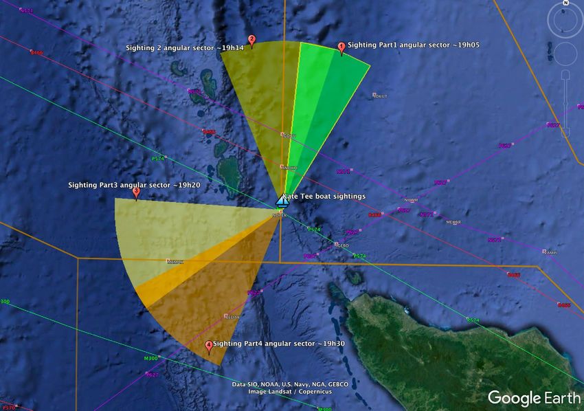
From Cocos Islands, Route T41 is the path to Learmonth on the Australian Continent while route
M641 is the path to Perth. The choice between the two options would certainly have been made based
on the unknown initial plan and fuel consideration. Subsequently, CAPTION favours Learmonth
(Route T41) as it could have just been reached, whilst Perth (Route M641) was out of reach at the
Cocos Islands decision point.
The journey stopped short well before the respective targets. As assumed in the Malaysian official
report [2], this is most probably due to the fuel exhaustion and the subsequent engines flame out. This
was confirmed by the results of the fuel consumption computation performed in this study.
Finally, the identified End of Flight (EoF) zone is found along Arc-7. Assuming it was following route
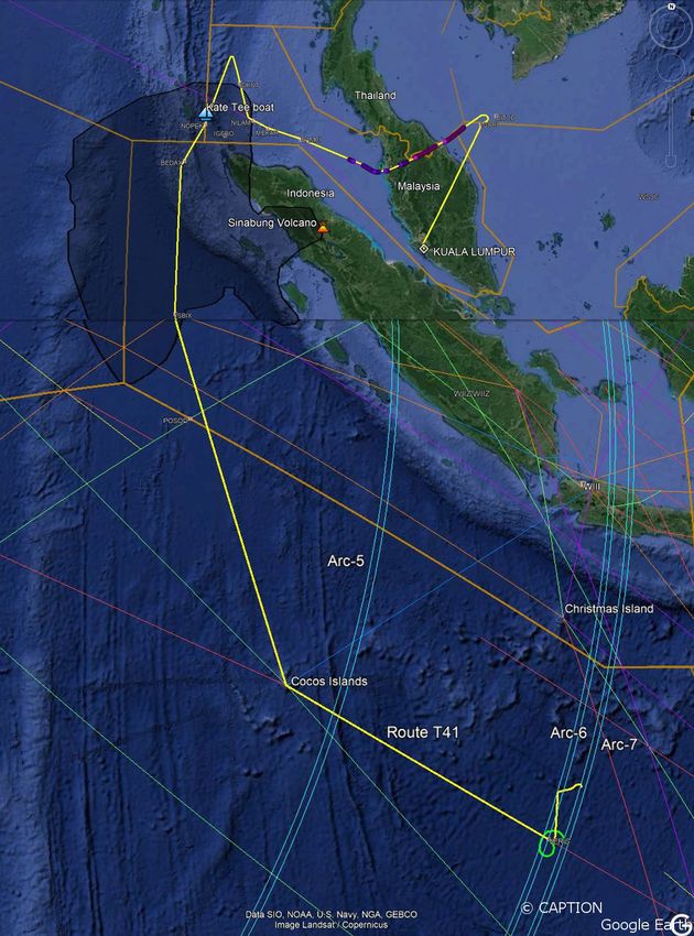
T41, the EoF would be located between ~15.7°S and ~17.5°S. Figure 1 illustrates the full trajectory
with two extreme variants at the end of flight after Arc-6.
Figure 1: CAPTION reconstructed piloted trajectory including NOPEK and Cocos Islands waypoints
2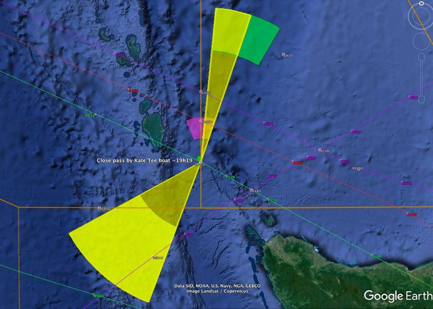
Table of Contents

1.      Introduction ................................................................................................................................... 5
2.      Objective ....................................................................................................................................... 5
3.      The transponder manual switch-off… and RAT deployment? ..................................................... 5
4.      New radar data from civil surveillance systems............................................................................ 6
5.      Sailor Kate Tee’s eye sighting report ............................................................................................ 7
6.      Mount Sinabung volcanic eruption and its ash cloud ................................................................... 8
7.      Seismic data recorded at Cocos Islands ........................................................................................ 9
8.      CAPTION Reconstructed Trajectory .......................................................................................... 10
9.      Key aspects of the identification of the trajectory....................................................................... 16
10.     CAPTION key events detailed description ................................................................................. 17
     10.1    Transponder switch-off ......................................................................................................... 17
     10.2    180° U-Turn after IGARI ...................................................................................................... 17
     10.3    Left Electrical Bus isolated or Electrical Power switch-off?................................................. 18
     10.4    RAT deployment (scenario 2) ............................................................................................... 18
     10.5    Manual piloting (scenario 2) ................................................................................................. 18
     10.6    Direct to KADAX waypoint (near Khota Baru).................................................................... 19
     10.7    Waypoints LOSLO, ENDOR, OPOVI, VAMPI and MEKAR ............................................. 19
     10.8    First officer mobile phone detected ....................................................................................... 19
     10.9    Exit from Western Hill radar coverage ................................................................................. 20
     10.10       Electrical power switched back on .................................................................................... 20
     10.11       Arc1 - first Inmarsat Ping .................................................................................................. 21
     10.12       Turn right to a northern direction ...................................................................................... 21
     10.13       End of turn to the north – Arc1.1 ...................................................................................... 22
     10.14       Start descent – Arc1.2 to IDKUT waypoint? .................................................................... 23
     10.15       Increased descent rate ........................................................................................................ 23
     10.16       IDKUT waypoint ............................................................................................................... 24
     10.17       Start of Phone Call -1 Attempt .......................................................................................... 24
     10.18       Phone Call-1 Attempt ........................................................................................................ 24
     10.19       End of Phone Call -1 Attempt ........................................................................................... 24
     10.20       Exiting Sabang radar coverage at ~10000ft....................................................................... 24
     10.21       Bottom of Descent ............................................................................................................. 24
     10.22       Major-Turn3 Left............................................................................................................... 25
     10.23       Ash cloud encounter? ........................................................................................................ 25
     10.24       Crossing routes N571 and P574 and descending to 3000ft ............................................... 26
     10.25       Passing by Kate Tee’s boat................................................................................................ 26
     10.26       NOPEK waypoint - Exiting Malaysian FIR ...................................................................... 26

                                                                           3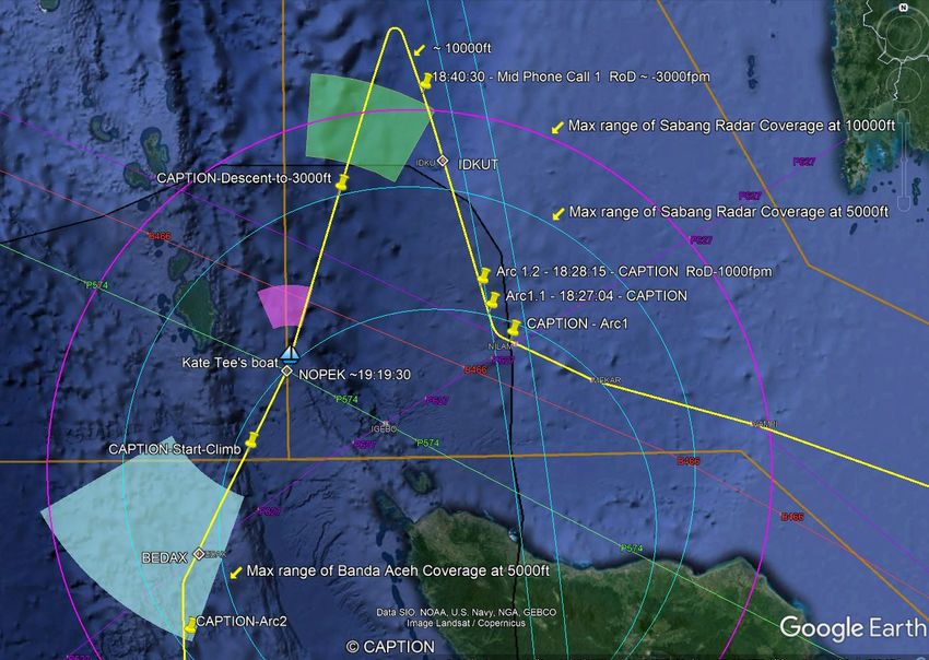
10.27        Start climb to 23000ft ........................................................................................................ 27
  10.28        BEDAX waypoint ............................................................................................................. 27
  10.29        ToC at 23000ft................................................................................................................... 27
  10.30        Major-Turn4 before a direct route to ISBIX waypoint...................................................... 28
  10.31        Arc2 ................................................................................................................................... 28
  10.32        ISBIX waypoint ................................................................................................................. 29
  10.33        Arc-3 .................................................................................................................................. 29
  10.34        Arc-4 .................................................................................................................................. 29
  10.35        Cocos Islands at 22:22:22 UTC ......................................................................................... 29
  10.36        Option 1: Arc-5 heading to Learmonth ............................................................................. 30
  10.37        Option 1: Phone call-2 attempt from the ground .............................................................. 30
  10.38        Option 1: VERIS waypoint? .............................................................................................. 30
  10.39        Option 1: Arc-6 ................................................................................................................. 31
  10.40        Option 1: Arc-7 ................................................................................................................. 31
  10.41        SATCOM Log-On Completed .......................................................................................... 32
  10.42        Option 2: Arc-5 heading to Perth ...................................................................................... 33
  10.43        Option 2: Phone call-2 attempt from the ground ............................................................... 33
  10.44        Option 2: Arc-6 ................................................................................................................. 33
  10.45        Option 2: Arc-7 ................................................................................................................. 34
  10.46        SATCOM Log-On Completed .......................................................................................... 34
  10.47        Initial plan: Learmonth or Perth?....................................................................................... 34
11.   How does CAPTION compare with Inmarsat data? ................................................................... 35
12.   What about fuel consumption?.................................................................................................... 39
13.   The End of Flight ........................................................................................................................ 40
14.   Conclusions ................................................................................................................................. 41
15.   References: .................................................................................................................................. 42
16.   Glossary: ..................................................................................................................................... 44
17.   Annex 1: Autonomy of the battery.............................................................................................. 45
18.   Annex 2: Kate Tee’s sighting ...................................................................................................... 50
19.   Annex 3: Volcano ashes .............................................................................................................. 50

Note: This document can be downloaded from
https://www.mh370-caption.net/wp-content/uploads/MH370-PlausibleTrajectory-CAPTION.pdf

                                                                          4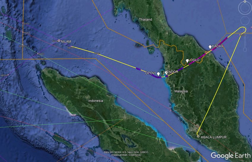
1. Introduction

Since the first analysis that reconstructed a plausible fully piloted trajectory by CAPTIO in [1] and
after the release of the Malaysian Final report [2], some complementary elements either became
available or deserved deeper investigation. The present report provides new findings on these elements
and proposes a new plausible piloted trajectory called CAPTION 3. The new factual elements are:
      1- The scenario of a manual switch-off of the transponder
      2- New radar data from civil surveillance systems of Kota Bharu and Penang publicly released
         by V. Iannello in [3]
      3- Sailor Kate Tee’s eye sighting report in [4] to [12] and analysed in detail in Annex 2.
      4- The Sinabung volcanic eruption and its ash cloud transportation as detailed in Annex 3.
      5- Seismic (infrasound) data recorded at Cocos Islands as analysed by Ed Anderson in [13].
From the results of detailed analyses of the points listed above, a revised plausible piloted trajectory is
reconstructed also using the full Inmarsat set of data, including those data that have often been ignored
by publicly available studies so far. This trajectory also follows the assumption that the aircraft flew at
a constant altitude between Arc2 and Arc6 minimising the number of changes of altitude.
In addition, a rationale is tentatively provided to explain some of the decisions possibly – and perhaps
logically – made by the People in Command (PIC) during the flight.
Elements from the CAPTIO study in [1] that are still applicable will not be addressed again in this
report, only new elements are presented as well as the complete CAPTION trajectory.

      2. Objective
The objective of this study is to determine a plausible piloted trajectory based on new and/or revised
pieces of information since the publication of the Malaysian final report.
Each of the elements listed above will be considered in sequence with an innovative perspective. All
the necessary information has been extracted from publicly available sources. Then, the resulting full
set of elements will be used as the basis for the refinement of the revised CAPTION trajectory.

      3. The transponder manual switch-off… and RAT deployment?
On his blog, V. Iannello provided a detailed description [14] of the active transponder manual switch-
off. The actions described and their timings correspond to the sequence of manual actions leading to a
proper switch off of the transponder and not to a “hard” disconnection by a power cut.
This new element is demonstrating that the hijacking could have been done from the cockpit. The
proper shutdown of the transponder means that electrical power was available until this moment at
least.
This means that the electrical power provided to the SATCOM - already analysed in a large number of
publications - was most probably shutdown at a later stage. Considering the various ways of cutting
the power, there are two possible scenarios for doing so.

3
    www.mh370-caption.net
                                                     5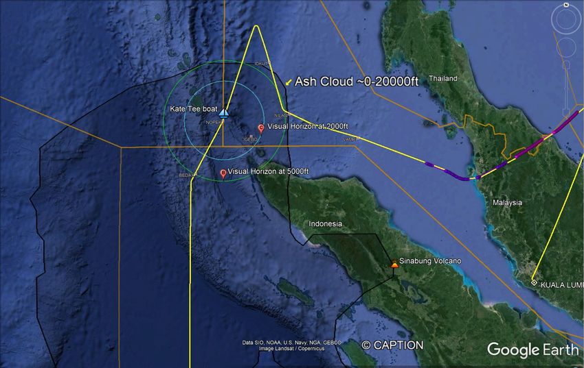
Scenario 1
The first scenario consists of isolating the left bus by switches on the overhead panel leaving the right
bus powering the basic functions of the aircraft but no longer the SATCOM, provoking its subsequent
hard logout. Nevertheless, under these circumstances the autopilot is fully functional and provides
lateral navigation (LNAV) and vertical navigation (VNAV) capabilities. Quasi-normal flight
conditions would have been ensured.
Scenario 2
The second scenario consists of isolating both main buses and thus all electrical generators, i.e. the
main generators (IDG), the backup generators and the auxiliary generator (APU), via the overhead
panel switches isolating both electrical transfer buses. This is strongly supported a-posteriori by the
occurrence of the power switch being back on (cf key event 10) later around 18:23:00 UTC.
This would have triggered the deployment of the RAM Air Turbine (RAT), which provides the
minimum electrical and hydraulic power necessary for flying the aircraft 4. It does not supply power to
the left bus which feeds the SATCOM equipment. An important aspect to keep in mind is that the
RAT does not charge the main battery - rated 47 Amps.hour - whose voltage at full capacity is about
27 to 28V. From this moment, the battery provided its share of electrical power. Gradually it
discharged itself until reaching the critical minimum voltage level of about 14V, which appears to be a
threshold at which the battery cannot contribute to supplying power anymore. In such a case some
systems could suffer a lack of power. From our simulations it appears that some important navigation
systems, like the ADIRU for example, could be among the first candidates in this case. During test
flights our simulator revealed that without reconnecting the electrical buses the battery voltage reached
this critical low level about one hour after main and backup buses’ isolation. This is equivalent to a
flown distance of ~480Nm. The analysis of the battery discharge and its potential consequences is
provided in Annex 1.
This would explain why the electrical power was re-established either before reaching this time limit
or after having experienced a battery low voltage occurrence, which by coincidence is about the same
time of the exit out of Western Hill radar coverage.
A consequence of the power supply by the RAT only is that temporarily Auto-Pilot (A/P) functions
were not available. Nevertheless, some FMS functionalities were most probably still available, such as
displaying waypoints on the navigation display and using them as guiding targets during the manual
piloting induced by such a situation (note: this is different from navigating with the VOR/DME aids).
Therefore, the manual piloting leg would have started somewhere after IGARI waypoint (probably
after the Major U-Turn-1 once the aircraft had been stabilised on a direct heading to Kota Bharu) and
it lasted until the electrical power re-establishment. After this switch back on, the A/P LNAV and
VNAV functionalities became available again, allowing the control of the flight in overflying
waypoints with RNAV precision as in a normal flight.
We estimate that the power was switched off between the re-entry in the FIR Singapore and BASIR
waypoint, as concluded in Annex 1 dedicated to the analysis of the autonomy of the battery.

       4. New radar data from civil surveillance systems
On his blog, V. Iannello released radar digital data from civil surveillance systems from Kota Bharu
and Penang [3]. This data clearly demonstrates that the aircraft flew a direct path to KADAX
waypoint, which is in the vicinity of Kota Bharu. Then it flew almost directly to ENDOR waypoint in

4
    On 20th Dec. 2018, LA8084 flight from Sao Paulo to LHR landed at Belo Horizonte (~90Nm away) powered by the RAT only
                                                                   6
the southeast of Penang Island, then it followed a northwest track to OPOVI waypoint and finally
headed directly to MEKAR waypoint in the northwest of the Malacca Straight.
Considering the shape of the trajectory provided by the radar data, which presents some irregularities
in its path, it is not clearly established that it was flown with the A/P in LNAV control mode. In fact,
this radar data is also compatible with a trajectory flown under manual control using waypoints as
guiding targets.

    5. Sailor Kate Tee’s eye sighting report
On her blog [7], sailor Kate Tee reported the eye sighting of a slow, low-flying aircraft during the
night of the 8th of March 2014 Malaysian time (~19:19:00 UTC on March 7th). A detailed analysis is
provided in Annex 2, including information directly provided by the sailor herself. It shows that her
testimony is coherent and credible if one accepts it was flight MH370. The timing and the bearings
visually measured by the sailor are compatible with a trajectory using NOPEK waypoint as a target (cf
Figure 2) with a slight turn at that point, followed by a direct leg to BEDAX waypoint.

                     Figure 2: Kate Tee’s eyes sighting sectors and corresponding timing
Verification has been performed to confirm that the estimated altitude, the sectors of viewing and the
speed are acceptable characteristics of a fly-by close to Kate Tee’s boat, either as a straight-line or as a
two-segment broken-line trajectory.
Thus, overflying NOPEK waypoint at ~19:19:30 UTC is a new key point taken into consideration
for the determination of the new 4D piloted trajectory presented below in this report.
In the selected trajectory below, the type of legs best suiting the overall path – in particular the
segment between ~18h40 and ~19h19 UTC – is a two-leg broken line turning at NOPEK waypoint
and targeting BEDAX waypoint as the next report point. The family of such possible trajectories is
illustrated by the Yellow sectors in Figure 3 for flying altitudes between 2000ft and 10000ft.

                                                     7
Figure 3: Family of possible 2-leg broken line paths at altitudes between 2000ft and 10000ft (Yellow area)

    6. Mount Sinabung volcanic eruption and its ash cloud
Kate Tee reports that during her sighting the aircraft appeared to be surrounded by an orange glow. A
possible interpretation is that this could have been caused by volcanic ashes. In fact, Volcanic Ash
Advisories (VAA) concerning Mount Sinabung on the 7th and 8th of March are mentioned in the
Malaysian Final report [2] section 1.7.2-3. Actually, the volcano had been continuously active
following a significant eruption in January leading to a quasi-permanent release of thin particles until
the beginning of March. Mount Sinabung volcanic eruption material and its ash cloud evolution have
been analysed in detail in Annex 3, thanks to simulation runs of atmospheric propagation models from
NOAA. It shows that ashes have spread from sea level up to a maximum altitude of 20000ft only and
would have been in motion reaching Kate Tee’s boat’s location in a two-day journey. For these
altitudes, Figure 4 sketches the geographical location of the ashes on 7th March at about 18:00UTC in
perspective with the angular sector of Kate Tee’s eye sightings.

                  Figure 4: Ash cloud location relative to Kate Tee’s boat at the time of the sighting

                                                           8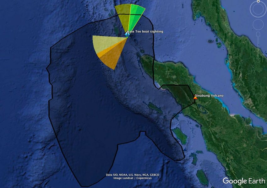
The conclusion is that an ash cloud was most likely present in Kate Tee’s boat’s area and in a
larger surrounding zone with a very high probability. Our simulation could not take into account
the accumulation from earlier days. Thus, our results are probably an underestimation of the true ash
concentration. This matches her sighting testimony and could explain the visual orange glow
phenomenon. In addition to this, the ash cloud’s ceiling might also explain the trajectory profile in that
area. In trying to avoid the ashes the aircraft descended at first and then subsequently flew above the
cloud. This fits well with the found optimum flight level of 23000ft after waypoint BEDAX.

    7. Seismic data recorded at Cocos Islands
On his blog [13], Ed Anderson published reports of studies on the possibility that infrasound and
seismic detectors had captured MH370 overflying Cocos Islands. The analysis of the few publicly
available screen shots of infrasound data from the IM.I06 array indicates that only one significant
acoustic event took place between the times of the 4th and 5th Inmarsat pings. This has been analysed in
more detail thanks to seismic data used as infrasound data and captured by II.COCO detector as part of
the Global Seismograph Network IRIS/IDA. The time of occurrence of this event is 22:22:22 UTC.
This is the time tag where the aircraft possibly passed above the seismic detector, which is located just
beside the Cocos Islands runway as illustrated in Figure 5. The records seem to indicate that the
incoming direction was probably from the northwest and the outgoing direction was towards the
southeast.
Unfortunately, some of the existing extra infrasound data are not publicly available for such an
analysis.

          Figure 5: Location of the infrasound detectors array and seismic detector at Cocos Islands

                                                      9
8. CAPTION Reconstructed Trajectory
Considering these new elements with a fresh eye, is it possible to identify a simple trajectory
reconciling all of them with the indisputable facts coming from the surveillance systems, the ACARS
messages and the Inmarsat data as well as adequate FMS flight modes? The positive answer is
illustrated in Figure 6 with its corresponding list of key events provided in Table 1 with two final leg
options provided in complementing Table 2 and Table 3. This list of events starts at IGARI waypoint
and finishes at the estimated end of the flight just after Inmarsat Arc-7, with two possible route options
after overflying Kate Tee’s boat and Cocos Islands.
The two route options have to be considered because their corresponding estimated BTO 5 and BFOs
match very well with the Inmarsat Arc-5 and 2nd phone call attempt measured data. Arc-6 and Arc7
crossing points can also be properly selected to match Inmarsat data. Between the two route options,
the one heading to Learmonth on the Australian continent is the one that best resists scrutiny.
The trade-off of altitude versus speed was analysed and simulated with our flight simulator with the
conclusion that, matching the key events timing and maximising the range, the optimum altitude was
~23000ft under VNAV control.
We chose the approach of using flight simulations because the flight dynamics and actual meteo make
theoretically computed average values too far from reality. The flight management system (FMS)
automation model needs to “fly” the trajectory in an almost actual context in order to provide the best
instantaneously induced flight parameters. In particular, the 4D interpolated quasi-real-time meteo data
is key and was input to the simulator every five seconds.
At this stage a caveat must be made: our flight simulator includes a B777-200LR model and not a
B777-200ER like the actual aircraft. The differences are threefold, the 9M-MRO B777-200ER
includes:
           a) Rolls-Royce engines instead of GE’s,
           b) a smaller wing area by 9m2 but includes winglets
           c) a smaller weight (~7 tons less)
Nevertheless, the results of the simulation will form the baseline for the new trajectory determination.
Thus, due to these small differences which have partial compensation effects, some imprecision will
exist, for example, the actual levelled altitude which may not be exactly 23000ft but would not be far
from it.
The final results are in accordance with the commonly accepted hypothesis that the engines provided
their quasi-nominal thrust capability until the end. The fuel consumption computation of this study
provides coherent results matching this assumption and estimates a near-total exhaustion of the fuel.
Nevertheless, the PIC decision taken at Cocos Islands, where they had the possibility of taking a direct
route to Christmas Island, which they did not take, shows to have been risky. Referring to the
temporary power supply regime by the RAT, or the battery discharge which led to losing some
capabilities among which possibly a reliable fuel consumption prediction, they could have been misled
on the value of the remaining fuel weight.
One could also think about a past similar situation when, in 1996, Ethiopian Airlines ET-961 hijackers
naively thought they had enough fuel to complete their planned journey.

5
    Inmarsat Burst Time Offsets (BTO) and Burst Frequency Offsets (BFO) are defined and analysed in Inmarsat paper [20]
                                                            10
Figure 6: Full CAPTION Trajectory enhanced by the newly considered events
11Table 1: CAPTION Trajectory key events with their time tag and location until Cocos Islands
Event Time Latitude Longitude Altitude Description Track Ground Vertical Est. Est. Inmarsat Inmarsat
Speed Speed BTO BFO 6 BTO BFO
UTC ° ° ft ° kt fpm μs Hz μs Hz
1 17:21:13 Transponder manual switch-off from the cockpit
2 180° U-Turn: could be with the A/P on or could
be manual
3 Electrical Power switch-off either:
1- In the cockpit by overhead panel switches
2- In the EEB by breakers opening
4 RAM Air Turbine deployment leading to systems
shedding
5 Manual piloting starts (i.e. no more LNAV &
VNAV functionalities)
6 Direct to KADAX (near Khota Baru) using Nav
Display waypoints as guidelines (cf radar data)
7 ~38500ft Legs LOSLO, ENDOR, (South of Penang Island), ~495kt
OPOVI, VAMPI and MEKAR
First officer mobile phone detected by a LBS
(Localisation Base station) at Bandar Baru Farlim
8 17:52:27 ~6Nm South of Penang Penang.
Exit from Western Hill radar coverage at 10 Nm
9 18:22:12 after MEKAR on route N571
Electrical power switched back on either:
1- to recover from the discharge of the battery and
the loss of the ADIRU
2- to get LNAV and VNAV back before the
discharge of the battery and the loss of the
10 ADIRU
11 18:25:27 6.778 95.931 38500 Arc-1: first Inmarsat Ping (logon request) 296.0 495 0 12520 142 12520 142
Turn right to a northern direction (repeat same
manoeuvre as at IGARI: exit radar coverage and
significant change of heading). Emergency
12 18:25:40 95.874 6.808 38500 recovery? 296.0 495 0
6
A bias of 150Hz is used for the BFO calculation
12Arc-1.1 (from SITA log file)
2 possible explanations for the small RoC :
1- referring to Richard Godfrey [15]: BFO / Hertz
increase in Turns (MH16 from Kuala Lumpur to
Amsterdam 7th March 2014 BFO Analysis) up to
7.4Hz
2- As the aircraft is finishing its turn, it is the roll
back to horizontal that makes the antenna speed
13 18:27:04 6.964 95.795 38500 ~120fpm 345.0 495 150 12470 168 12520 175
Arc-1.2 (from SITA log file) start descent at -
1000 fpm while under Sabang radar coverage.
14 18:28:15 7.134 95.740 38500 (ECON descent at IAS 240kt) 342.5 492 -1000 12460 142 12480 143
Increase descent -3000fpm (with speed brakes to
15 18:33:15 7.860 95.541 36500 get quicker under 10000ft) 342.5 -3000
16 18:35:25 8.005 95.504 28000 IDKUT waypoint 342.5 406 -3000
17 18:39:58 8.400 95.392 16000 Start-Phone Call -1 attempt 342.5 347 -3000 89 88
18 18:40:33 8.462 95.372 15200 Phone Call 1 attempt 342.5 347 -3000 89 87
19 18:40:56 8.494 95.364 14000 End of Phone Call 1 attempt 342.5 335 -3000 ~12450 89 89
20 ~18:41:30 Exit from Sabang radar coverage at 10000ft
~5000-
21 ~18:43:45 8.804 95.263 ~10000 Bottom of Descent 342.5 277
Major-Turn3 Left after descent. Repeat same
manoeuvre for the third time as at IGARI and at
~5000- 18:25:40: exit radar coverage and significant
22 18:46:45 8.917 95.188 ~10000 change of heading. 270 277
~5000- Entry into the ash cloud (estimated from sea level
23 ~19:05:00 7.985 94.850 ~10000 up to 20000ft) 198 ~276
~5000- Start descent to 3000ft possibly for ash avoidance
24 ~19:06:00 ~10000 manoeuvre 198 ~270
25 19:19:00 6.634 94.428 3000 Passing close to Kate Tee’s boat (~19:19:00) 198 262
26 19:19:30 6.604 94.417 3000 NOPEK (Exiting Malaysian FIR) 208 269
Start climb to 23000ft (VNAV ECON Climb) ~3500/
27 ~19:30:10 5.871 94.042 3000 IAS 298/0.620M 208 270 ~4500
28 ~19:36:00 5.364 93.788 20000 BEDAX 208 395 ~4000
ToC at 23000ft (then select mode: VNAV CRZ
29 ~19:37:00 5.271 93.730 23000 ECON) 268/0.619M 208 414 0
30 ~19:37:30 5.169 93.691 23000 Major-Turn4 before Direct to ISBIX 192 393 0
31 19:41:03 4.783 93.690 23000 Arc-2 180 390 0 11540 111 11500 111
1332 20:22:00 0.365 93.670 23000 ISBIX 180 386 0
33 20:41:05 -1.611 94.163 23000 Arc-3 166 385 0 11730 147 11740 141
34 21:41:27 -7.832 95.716 23000 Arc-4 166 381 0 12790 169 12780 168
35 22:22:22 -12.201 96.840 23000 YPCC - Cocos Island 166 380
At Cocos Islands a decision had to be made on the next leg. If the assumption is made that the PIC went on using documented waypoints, there are two suitable
candidate routes i.e.T41 and M641 towards Learmonth and Perth respectively. At the current altitude and speed, they both post excellent compatibility with Inmarsat
data at Arc-5 and at the phone call of 23:14 UTC. On the contrary, to the North-East, route G200 to Christmas Island is incompatible with these Inmarsat data. If the
PIC stopped following waypoints then there would be a large family of possibilities.
How to decide between the two routes T41 and M641? If one assumes that the PIC did actually target an airport for landing, then the consideration of the remaining
weight of fuel onboard and its corresponding maximum range will provide a way to choose. Our fuel computations and consumption simulations indicate that around
~10T of fuel would have remained at Cocos Islands. The distance between Cocos Islands and Learmonth is ~1160Nm while Cocos Islands are ~1600Mn away from
Perth. The Flight Crew Operational Manual (FCOM) indicates that, with zero wind, Learmonth could have been potentially reachable with 14 tons while Perth
would have needed at least 17.5 tons. Proceeding to Learmonth direction is also the choice by default because it is the shortest route to reach the Australian continent
and could have been the target of the PIC’s plan that could not be followed eventually.
Consequently, the logical choice would be to take route T41 towards Learmonth which will be the first to be analysed. But as the end of flight at Arc-6 and Arc-7 on
route M641 posts interesting features, this one will be analysed also. Table 2 presents option 1 to Learmonth and Table 3 presents option 2 to Perth.
Option 1: Route T41 to Learmonth
Table 2: CAPTION Trajectory key events with their time tag and location on route T41 to Learmonth from Cocos Islands till the End of Flight (Option 1)
36 22:41:22 -13.214 98.415 23000 Arc-5 123.5 377 0 14590 206 14540 204
Phone Call from 23:14:01 to 23:15:02
BFO is 217Hz on average as provided by Inmarsat.
From this point several alternate paths are possible
37 23:14:30 -15.115 101.440 23000 without using waypoints 123.5 372 0 219 0 217
Southern option among the alternate paths:
38 23:54:25 -17.270 105.001 23000 VERIS 123.5 362
39 00:10:58 -15.813 105.307 23000 Arc-6 35 359 0 18020 251 18040 252
40 00:19:29 -15.711 106.108 5000 Arc-7: according to best BFOs 180 350 -3000 18400 180 18400 182
SATCOM Log-On Completed – probably ditching
41 00:19:37 -15.332 106.290 0 at this Last point 175 150 -13600 18440 -1 18410 -2
Note Distance Cocos Islands to Learmonth= 1160Nm
14Option 2: Route M641 to Perth
Table 3: CAPTION Trajectory key events with their time tag and location on route M641 to Perth from Cocos Islands till the End of Flight (Option 2)
42 22:41:22 -13.673 98.051 23000 Arc-5 141.3 377 0 14510 201 14540 204
Phone Call from 23:14:01 to 23:15:02
43 23:14:30 -16.267 100.221 23000 BFO is 217Hz on average as provided by Inmarsat. 141.5 372 0 217 0 217
44 00:10:58 -20.099 103.623 23000 Arc-6 close to route M641 60 359 0 18040 252 18040 252
45 00:19:29 -20.311 104.323 5000 Arc-7: according to best BFOs 180 350 -3200 18410 182 18400 182
SATCOM Log-On Completed Ping 28 - Last point
46 00:19:37 -20.313 104.324 0 ditching 180 150 -14000 18410 -2 18410 -2
Note Distance Cocos Islands to Perth= 1600Nm
Section 10 provides details on each key event along with complementary information and/or its justification. The paragraph numbering follows the events numbering
making the reading easier.
159. Key aspects of the identification of the trajectory
The reconstructed trajectory was built taking into account all the extra elements presented in Sections
3 to 7 which provide additional waypoints to consider with some indication of timings.
In addition, a large number of real-time simulations were performed taking into account the quasi-real
meteorological conditions along the flight. Philippe Gasser, during the CAPTIO initiative, has
developed a specific add-on software application feeding our FsX-PMDG simulator with the input of
4D-interpolated Nullschool meteo data [16] every 5 seconds.
During these simulations, several VNAV (Vertical Navigation) flying modes have been tested. Table 1
figures result from the best simulation which after Arc-1 used a sequence of three successive B777
flying modes best adapted for the corresponding phases of flight as the aircraft descended, climbed
and flew level. From Arc-1.2 until the climb after flying by Kate Tee’s boat the aircraft simulator
automatically selected a 240kt Descent mode. The follow-up climb phase was flown in ECON Climb
mode. And the long leg from the top of this climb just before Arc-2 until Arc-6 was flown in ECON
Cruise mode at 23000ft. The cost index had been set to 0 after IGARI to maximise the range.
Thus, there was NO MANUAL CHANGE OF SPEED from Arc-1. The speed evolution came only
from the FMS automation algorithms of the automatically selected flying modes as the FMS interprets
by itself the pilot changes of altitude accordingly. Thus, from Arc-1 onwards the speed was
continuously automatically controlled by the aircraft. Thus, from the top of the climb after BEDAX
waypoint, the FMS automatically and continuously adjusted the speed slightly by few knots to take
care of the continuous fuel weight decrease.
The CAPTION reconstructed trajectory BFOs in both options matches the available Inmarsat
measured BFOs and BTO. The standard deviation of the BFO residuals (BFORs) is ~2.3Hz for both
options. When considering the available extra BFOs (like those we named Arc-1.1 and Arc-1.2 for
example), which are not usually considered by the other studies, the BFOR σ becomes ~3.5Hz.
For both route options, the computed fuel consumption results in a fuel weight value lower than the
precision of the model meaning that at Arc-6 and Arc-7 the remaining fuel weight was close to zero.
This result matches normal flight expectations with engines quasi-nominally performing as assumed in
the official report [2]. The end of flight was provoked by a sequential flame out of the engines due
to fuel exhaustion in the vicinity of Arc-6.
1610. CAPTION key events detailed description
This section provides the rationale for each key event with complementary information and graphical
illustrations when necessary. Let’s remember that a large number of ground speed figures are not
computed averages via the ratio distance over time, but they are provided by our simulator and come
exclusively from the FMS automation itself using the input of the actual local meteo conditions
provided every 5 seconds via 4D-interpolated Nullschool data publicly available in [16].
Let’s analyse the key events one by one once the aircraft was levelled just after its top of climb and
just after IGARI waypoint heading to BITOD waypoint as illustrated in Figure 7 by the yellow arrow.
It was in a Singaporean control area delegated to Kuala Lumpur Air Traffic Control (ATC).
Figure 7: MH370 flight leg fully traced by ATC until its Secondary Radar label disappearance
10.1 Transponder switch-off
This refers to Section 3 “The transponder manual switch-off… and RAT deployment”. It is most
probable that this was done manually in the cockpit. Not only would this make the aircraft information
disappear on the secondary radar ATC and military displays, but also mislead the military tracking
algorithms which did not properly capture the U-turn in real-time. It took several days for the military
to reconstruct the flight path and the 180° turn.
10.2 180° U-Turn after IGARI
Being “invisible” to the Civil ATC and “isolated” from the military, the aircraft performed a quick U-
Turn. This was made at the boundary of the military radar coverage and in the Vietnamese ATC area.
Military data shows a turn but this capture was an incomplete tracking as the ADS-B data disappeared.
Thereafter, several disconnected legs needed several days to be identified and linked together.
The turn could have been performed via the auto-pilot as described by V. Iannello [3], but
alternatively it could have been driven fully manually, as shown by our simulations. Both ways show
similar characteristics of the U-Turn.
This was cleverly perpetrated at the limit of the radar coverage following a model repeated several
times later: exit radar coverage, change direction (and possibly altitude) and re-enter the radar
coverage “as a new flight” with no recent history for that radar (cf paragraphs 10.12 and 10.22).
1710.3 Left Electrical Bus isolated or Electrical Power switch-off?
There is basically no doubt that some or all of the electrical power was switched-off voluntarily. The
exact time when the Electrical Power switch-off occurred is unknown. But the absence of an ACARS
routine message due at ~17h37 and the impossibility at 18:03 for a phone call from the ground to be
forwarded to the AES provide an estimate of the last moment of the switch-off. The SATCOM did not
transmit any data nor any signalling information between 17:07 and 18:03 which means that, at least,
the left bus had been unpowered as there was no proper logoff from the AES which is powered by this
bus.
There are two possibilities for performing such a switch-off: either in the cockpit by isolating the
corresponding generators via switches on the overhead panel, or in the Electronic Equipment Bay via a
manual hard disconnection of breakers of the left and right main transfer buses. The cockpit scenario is
most probable since it has been demonstrated that the transponder was manually, properly switched
off.
In the case of an action in the cockpit, two scenarios (or interpretations) are possible (cf Sect. 3):
1- The left bus only has been unpowered and the aircraft went on powered by the right bus and
under the control of the auto-pilot (Scenario 1).
2- All the five generators have been isolated which is equivalent to a complete switch-off of the
electrical power. Subsequently, this would have triggered the take-over by the Standby buses
with the deployment of the RAT (Scenario 2).
More details on the electrical switch off cases have been provided in Annex 1 of the CAPTIO analysis
report [1].
Both scenarios lead to the same trajectory and same timing. Our opinion is that Scenario 2 provides a
convincing rationale for the power switches being back on later at ~18h23 UTC.
10.4 RAT deployment (scenario 2)
The RAM Air Turbine (RAT) automatically deploys as the ultimate electrical and hydraulic power
supply before the battery. As a consequence of the limited power supplied by the RAT, the Electrical
Management System had to perform some systems shedding in order to match the available energy
supply (note: it is not sure if shedding is still active in such a minimum power situation).
In addition, a RAT critical feature is that it does not supply power for charging the main battery (cf
FCOM). To the contrary, the battery energy contributes to power some of the equipment (possibly
under the EMS supervision, tbc). Thus, it decreases and its voltage consequently i.e. from the nominal
27V down to approximately 13V. At this voltage level the battery stops supplying power.
Thus, after the U-Turn, the RAT and the main battery were most probably the only sources of
electrical power.
10.5 Manual piloting (scenario 2)
Because of either a systems shedding or a pre-established degraded mode configuration, some
functionalities ceased operating, in particular the auto-pilot functions like the LNAV and VNAV,
forcing the PIC to pilot the aircraft manually. This is possible by using waypoints as simple guiding
navigation targets displayed on the navigational display (ND) with the intentional path indicated in
dotted lines. Once a waypoint is entered in the FMC, a purple direct route is displayed on the ND. The
pilot needs only to adjust the heading to follow the provided purple line.
1810.6 Direct to KADAX waypoint (near Khota Baru)
Considering the publicly available radar data, after the U-Turn the aircraft path followed a Direct to
KADAX waypoint in the northwest of Khota Baru. The U-turn was a constant left turn to a south-
westerly direction i.e. a 180° turn to the left to a track almost parallel to the boundary of Kuala
Lumpur FIR and Bangkok FIR and back towards the Malaysian Peninsula, in the direction of the
waypoint KADAX. It overflew this point before proceeding over the Malaysian inland.
10.7 Waypoints LOSLO, ENDOR, OPOVI, VAMPI and MEKAR
From KADAX waypoint to the south of Penang island (ENDOR and OPOVI) the flight path followed
the FIR boundary between Bangkok FIR and Kuala Lumpur FIR first and Bangkok FIR afterwards.
This was done on purpose so that the Air Traffic Management (ATM) controller on duty on each side
of the boundary might have assumed that his or her counterpart controller was actually controlling the
aircraft.
People in Command wanted the aircraft to be seen as flying a standard trajectory along waypoints and
standard routes especially in such a sensitive area like the Malacca Straight monitored by Kuala
Lumpur and Bangkok civil and military ACCs.
After Penang, the flight took the direction of waypoints VAMPI and MEKAR with a quasi-over-flight
of Pulau Perak Island. At 18:03 UTC, a phone call attempt from the ground AOC did not go through.
These legs, including leg 10.6, are well-documented thanks to the civilian radar data of the approaches
to Khota Baru aiport and to Penang airport as provided in [3] and illustrated in Figure 8.
Figure 8: Clever path in-between Malaysia and Thailand FIRs depicted by the civilian radar plots (Purple)
10.8 First officer mobile phone detected
When passing to the south of Penang Island between waypoints ENDOR and OPOVI, the first officer’s mobile
phone was detected by a Penang mobile phone terrestrial communications system at 17:52:27UTC. This
provides a key point in two aspects: the geographic location and the timing. No clear interpretation so as to why
only this gsm was detected and why other mobiles were not, such as the pilot’s or the passengers’ for example.
1910.9 Exit from Western Hill radar coverage
The maximum detection range of the Western Hill Penang radar is ~255Nm. Nominally, the radar can
only detect aircraft flying at altitude ~31000 ft and above, with a 5000 ft height precision. The range
of the aircraft last detected spot is ~243NM which is consistent with the radar capability.
The aircraft disappeared from the military radar records of this radar at 18:22:12 UTC. The Last Radar
Spot Position (LRSP) is at approximately10NM beyond MEKAR waypoint in the northwest direction
on route N571 i.e. ~(6.5770N, 96.3423E) along the corresponding track of 296°. This is illustrated in
Figure 9.
According to the latest estimation, when exiting the radar coverage, the aircraft is supposed to have
flown at ~38500ft with a ground speed of around ~495kt.
Figure 9: Exit from Western Hill radar coverage and Arc-1 crossing
10.10 Electrical power switched back on
The electrical power of the AES was switched back on just after exiting the Western Hill radar
coverage meaning that the left electrical bus was re-powered. Bearing in mind the necessary time for
booting, it is estimated that this occurred at ~18:22:30 UTC. Is it a coincidence or a well-thought
action?
If the right bus was not isolated and was still powering the aircraft, there would have been no reason to
reactivate the left bus as the aircraft would have been fully functional at this point in time. It could
have continued that way under the same “semi degraded” situation. Still, maybe reactivating some
comfort systems was a possible reason, although this is a weak explanation. Most probably the left bus
re-powering was the consequence of a full electrical power re-activation and this must have been
necessary, but why?
During our simulations, we tested the flying of the leg IGARI to MEKAR where the power supply was
provided by the RAT in conjunction with the main battery. In such a case, the battery discharge led to
20a decreased voltage reaching ~13/~14V, while delivering ~46A, in the vicinity of NILAM at about
~20Nm after the estimated power switch-back (cf Figure 9) showing that the simulator coherently
modelled the battery’s behaviour. As a consequence, the ADIRU lost its power with a message
displayed on FsX Main Function Display MFD: “NAV ADIRU INERTIAL” as shown in Figure 24 of
Annex 1: Autonomy of the battery. It would mean that the SAARU took over and during 3 minutes it
provided NAV info based on the last ADIRU data. This would lead to a more complicated way to
properly navigate because the SAARU must be realigned from time to time afterwards.
Thus, two interpretations are possible:
1- Reconnection of the generators via the buses’ reconnection before a complete battery
discharge and get LNAV and VNAV back in full operation preventing discharge of the battery
and the loss of the ADIRU. The battery is rated for 47 Amps.hour and the FsX-PMDG
simulator posted ~13V and 46A when triggering the ADIRU off message. This is consistent
with the capacity limit of the battery showing good modelling of its behaviour.
2- to recover from the emergency coming from the actual discharge of the battery and the loss of
the ADIRU
Referring to the assumption that the PIC had an initial plan in mind, the return of the power at such a
point in time raises a valid question. Was this part of the plan, or was it a response to the emergency
arising from the sudden loss of control information and navigation capability of the aircraft in a
delicate, degraded situation? This should be placed in the context (cf below) of the presence of
surrounding traffic: an Emirates flight close behind and Indigo traffic coming ahead and to stay
undetected.
Other interpretations are possible but are less convincing, such as re-establishing some functions to
ensure a more comfortable environment with full instruments or systems operational for the cabin, for
example.
10.11 Arc1 - first Inmarsat Ping
The consequence of switching the electrical power back on is that the SATCOM of the AES (SDU)
rebooted and began to function, producing the first Inmarsat ping with a logon request coming from
the aircraft also called Arc-1. This proper logon is an a-posteriori confirmation that the SDU did not
log off properly earlier on.
This logon request was recorded at 18:25:27 UTC and only concerned the SDU while selected systems
controlled from the cockpit remained off, like VHF Radios and the SSR transponder for example. As
the SDU is located in a separate location (in the cabin ceiling close to the middle-rear), the People in
Command probably overlooked it or they simply were not aware of the way it is powered. In any case,
they had no control of it and had just to take their chance. The CAPTION Arc1 crossing location is
shown in Figure 9.
10.12 Turn right to a northern direction
The sequence of actions i.e. exiting radar coverage and making a significant change of heading recalls
the manoeuvre executed after IGARI where the aircraft flew at the limit of radar coverage and turned
back. The rationale for this turn here after NILAM might be the conjunction of several reasons: the
surrounding traffic (Emirates flight EK343 closely following but more importantly Indigo flight 6E53
ahead of schedule and coming ahead) as well as Sabang radar avoidance in addition to a possible
change of plan after the emergency arising from possible battery discharge consequences.
21This manoeuvre proceeded using the same principles: when potentially seen by one surveillance
system, get out of its reach and then execute a diversion to mislead real-time tracking systems which
could not make the connection between these different unlinked radar plots going out and coming
back in different directions.
The initial intention could have been to perform a simple descent while on route N571. But the
proximity to the surrounding traffic may have put pressure on the PIC who reacted differently to the
original plan.
Our opinion is that after leaving Western Hill coverage and in order to avoid the surrounding traffic to
be able to pass under route N571, the aircraft turned north and descended to get out of range of the
Sabang radar coverage potentially capable of tracking it. Thus, its next move was to exit this coverage
completely. IDKUT is the most appropriate waypoint that could be used in the direction provided by
the best BTO/BFOs. This was possible thanks to the LNAV function back in operations. Figure 10
sketches this manoeuvre.
Figure 10: Leg after Arc1 including a northern turn to IDKUT
(Green area is Western Hill radar coverage, Purple area is Sabang radar coverage at 10000ft)
On that day, Sabang Radar was not operational. It is operated part-time for fuel-saving reasons.
Whether the PIC were aware of this is unknown.
10.13 End of turn to the north – Arc1.1
SITA communication log files report that at 18:27:07 there was a set of BTO and BFO that could be
considered. So far, they have not been considered but just mentioned by most of the analyses of which
we are aware. They will be used here to infer CAPTION trajectory, as well as few others at later times.
At this time the BTO provides the information that the plane had to turn and the BFO matches only a
northern turn. But, considering all track directions, no track leads to a BFO within the Inmarsat
measured 175 ±7hz margin. The best BFO of 165Hz was found at 345°. But, considering waypoint
IDKUT as the target and an approximate aircraft ground speed of around ~495kt, it was found that to
match the Inmarsat measured BFO, the rate of climb (RoC) must be ~150 fpm. This could come from
22a small fluctuation after the turn as there are two possible, non-exclusive explanations for this small
RoC:
1- referring to Richard Godfrey’s analysis [15], during turns, the BFO increases up to 7.4Hz
instead of the admitted 7Hz.
2- As the aircraft was finishing its turn to the right and thus was banking to the right, the roll
back to the left to return to the horizontal made the antenna move upwards and towards the
satellite with an estimated speed of ~120fpm.
Arc1.1 is illustrated in Figure 10. At this point the aircraft route is estimated at ~342.5° on route to
IDKUT waypoint.
The reason for initiating the right turn to the north cannot be found in the technical data. One
interpretation is that it was not planned initially but was provoked by an emergency situation and by
the presence of Indigo traffic 6E53 incoming ahead which took off from Chennai 30 minutes ahead of
schedule. Thus, instead of descending and exiting out of Sabang radar coverage on route N571 and
then turning left, the PIC may have decided to perform this diversion another way in safer conditions
and also, maybe to not be seen by this traffic.
10.14 Start descent – Arc1.2 to IDKUT waypoint?
SITA communication log file reports that at 18:28:15 there is a set of BFOs that could be considered.
At this point in time, two options are possible. The first one, already described in CAPTIO study [1],
is to consider that the aircraft was proceeding with a contingency procedure and had turned left back to
track 296° before starting a descent parallel to route N571. This has been also considered by the IG in
[17] but in this case the flying by Kate Tee’s boat is not timely and is missed by ~25 minutes i.e.
18:53:46 UTC compared to ~19:19:00 UTC. According to this timing, when the sighting took place,
the aircraft would have been already gone by 120 Nm to the southwest. This does not fit the testimony
and its analysis provided in unprecedented detail in Annex 2.
The second option to consider is evoked in paragraph 10.13 which is: no turn left but continuing on a
northern direct route to IDKUT waypoint. At this time and location - on its way to IDKUT - the
aircraft flying at approximately ~490kt, the rate of descent (RoD) has to be -1000 fpm to match the
Inmarsat BFO. Thus, the aircraft must have initiated a descent corresponding to the FMS 240kt (or
250kt) Descent mode. The aircraft route is still estimated at ~342.5°.
This is illustrated by the ARC1.2 pin in Figure 10.
10.15 Increased descent rate
Considering the Sabang radar surveillance capability in this area, and in order to fly by Kate Tee’s
boat at about 19:19:30, the aircraft must have turned sharply southwards at some point. To match this
timing, we are of the opinion that the PIC accelerated the descent of the aircraft in order to get more
rapidly out of the Sabang Radar coverage in order to repeat their “now becoming usual” manoeuvre:
get out of radar coverage, turn and come back as a different flight impossible to be linked with the
profile flown a few minutes ago. They probably used the speed brakes to achieve a descent rate of
about ~-3000fpm. This is a usual B777 practice for achieving a fast descent because it is a very good
glider. An additional reason for this increase of rate of descent might also be an ash cloud avoidance
manoeuvre as explained later in the note of paragraph 10.23 and visible in Figure 11.
We are of the opinion that after this descent they performed a left turn when being undetectable by the
Sabang radar, i.e. when flying at an altitude of 10000ft or below as illustrated in Figure 10 repeating
23You can also read