Monitoring of subtidal reef biota off Motuotau Island in relation to dredge spoil dumping by the Port of Tauranga Ltd 2014-2018 ERI Report no. 118
←
→
Page content transcription
If your browser does not render page correctly, please read the page content below
Monitoring of subtidal reef biota off Motuotau Island in relation to
        dredge spoil dumping by the Port of Tauranga Ltd
                            2014-2018
                         ERI Report no. 118

                                                                   1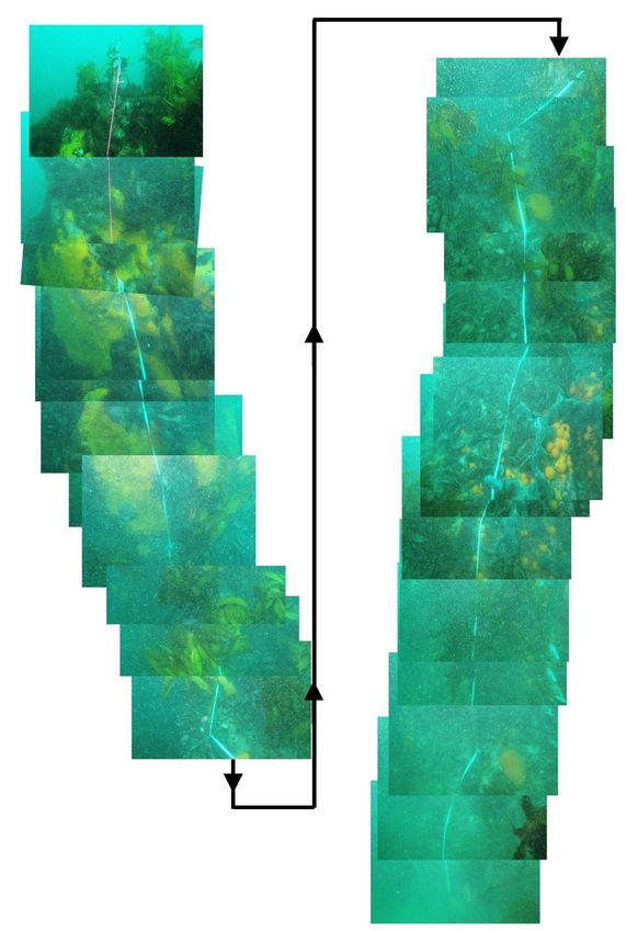
Prepared for the Port of Tauranga Ltd by

Phil Ross
Environmental Research Institute
Faculty of Science and Engineering
University of Waikato, Private Bag 3105
Hamilton 3240, New Zealand

Cover image:
Construction diver Glen Ladkin installing survey marker pins at Motuotau in 2014

Cite report as:
Ross, P.M. 2018. Monitoring of subtidal reef biota off Motuotau Island in relation to dredge
spoil dumping by the Port of Tauranga Ltd, 2014-2018. Environmental Research Institute
Report No. 118. Client report prepared for the Port of Tauranga Limited. Environmental
Research Institute, Faculty of Science and Engineering, The University of Waikato, Hamilton.
28pp.

Reviewed by:                                              Approved for release by

Kaeden Leonard                                            John Tyrrell
Research Fellow                                           Acting Director
Coastal Marine Field Station                              Environmental Research Institute
University of Waikato                                     University of Waikato

                                                                                          2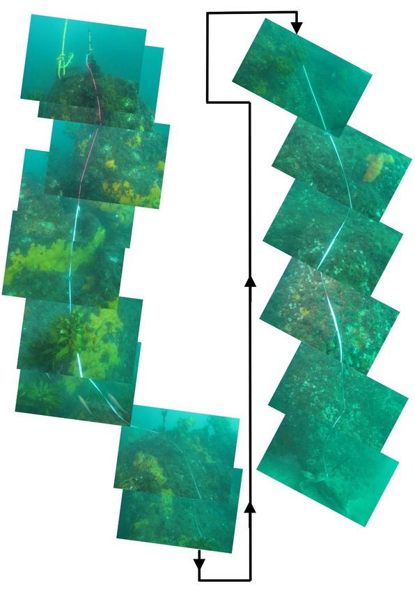
Executive Summary
Background
Dredge spoils generated from the development and maintenance of the Port of Tauranga
is disposed of on the inner shelf off Mt Maunganui.
Major channel deepening and widening programmes were undertaken in 1992 and
2015/16. Maintenance dredging is undertaken more regularly.
Since 1990, monitoring has been conducted to determine if the dumping of dredge spoils
was affecting subtidal reef communities around Motuotau Island, as island off Mt
Maunganui beach and inshore of the dredge spoils disposal area.
Three sites at Motuotau have been monitored since 1990. A site to the east of Motuotau
has been monitored as a control site and two sites to the north-east and north-west of
Motuotau have been monitored as impact sites.
Monitoring has consisted of photographic monitoring of permanent transects close to
the reef-sand boundary to record (a) changes in the elevation of the seabed relative to
the rocky reef, and (b) changes in the biological community over time.
Monitoring has taken place in 1990, 1991, 1993, 1995, 1998, 2001, 2006, 2009 and 2012.
One of the difficulties of the monitoring programs was that the marker pins, which are
cemented onto the reef, would often be dislodged between surveys and would need to
be reinstated prior to each new survey taking place. This made it difficult to be sure that
the same section of reef was monitored on each occasion and that the measurement of
changes in seabed height was accurate.
In 2013, a decision was made to reinstate marker pins for the permanent transects. In
January 2014, holes were drilled into the reef and stainless steel rods were secured in
these holes using epoxy cement. It is unlikely that these marker pins will ever be
dislodged from the reef.
At the same time, the monitoring methodology was reviewed and a number of changes
recommended. Most significantly, it was decided that the reef being monitored as a
control site did not really constitute a control against the effects of dredge spoil dumping
and subsequently all three sites would be considered as impact sites.
Monitoring took place in January and May 2014, November 2015 and April 2018 and is
reported on here.
Findings
Marker pins were reinstated in January 2014 and four and a half years later remain solidly
in place.
In general terms, the reefs around Motuotau appear to be healthy and in a state that is
comparable to other reefs of similar depth, aspect and exposure along the Bay of Plenty
coastline.
The 2014, 2015 and 2018 surveys did not record any major changes in the biological
communities of the reefs around Motuotau.
Measurements of the distance between the bottom marker pin at each site and the reef-
sand boundary indicate that the reefs are not being inundated by dredge spoils. Seabed
3
heights have fluctuated by as much as 30 cm since 2014 and this is not thought to be
outside the scale of fluctuations that would naturally occur given the aspect and energy
environment of the surveyed reefs.
Photographic surveys continue to prove useful in capturing information about the
diversity of subtidal reef communities. Although there is some evidence of minor changes
in these communities over time this is to be expected. There is also evidence of stability
in these communities with a number of sponges on these transects having been present
for several decades.
4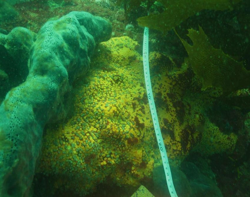
Introduction
(For full introduction see Grace 1997)
In order to maintain usable and safe shipping channels to the Port of Tauranga, it is necessary
to periodically dredge several million tonnes of estuarine seafloor sediment from the
entrance and main shipping channel of Tauranga Harbour. The dredged material is deposited
on the inner continental shelf, offshore of Mt Maunganui, in accordance with conditions
outlined in the Port of Tauranga’s resource consents. Major dredging programmes were
undertaken in 1992 and most recently in 2015/2016. Dredging is conducted periodically to
maintain the depth of the shipping channel.
In 1990 a monitoring programme was established to identify any possible impacts of dredge
spoil dumping on nearby subtidal rocky reef communities. Three monitoring sites were
established around Motuotau Island. A site to the east of Motuotau has been monitored as a
control site and two sites to the north-east and north-west of Motuotau have been monitored
as impact sites. Surveys conducted in 1990 and 1991 were undertaken prior to the large scale
dredging programme of 1992. Subsequent surveys were conducted in 1993, 1995, 1998,
2001, 2003, 2006, 2009 and 2012. Monitoring has consisted of photographic monitoring of
permanent transects close to the reef-sand boundary to record (a) changes in the elevation
of the seabed relative to the rocky reef, and (b) changes in the biological assemblages
(invertebrates and algae) over time. Seabed elevation was considered a good indication of
whether dredge spoils were being transported inshore and smothering coastal reefs.
Biological communities at these site were considered to provide an indication of ecological
health of reef communities. This was based on the premise that for an organism to exist in an
area all its ecological requirements must be met. If a change in the environment occurs, a
subsequent shift in the biological community should result. Because sessile benthic organisms
(plants and animals attached to the sea floor) cannot migrate to more favourable areas, the
density and composition of this group is considered a good measure of recent environmental
conditions.
One of the weaknesses of the monitoring programs was that the marker pins, which up until
now have been cemented into shallow crevices in the reef, would often be dislodged and be
missing from the reef. Typically, at least four or five marker pins would need to be reinstated
each survey. This was time consuming and made it difficult to ensure that the exact same
section of reef was being monitored on each occasion. It also made it impossible to accurately
measure changes in seabed elevation over time. In 2013, the decision was made to more
securely reinstate the survey marker pins. In January 2014, holes were drilled into the reef
surface and stainless steel rods were cemented into these holes. Given the methods used it
is unlikely that these marker pins will ever be dislodged from the reef. At the same time, the
monitoring methodology was reviewed and a number of changes recommended. Most
significantly, it was decided that the reef to the east of Motuotau that was being monitored
as a control site did not constitute a control site and subsequently all three sites would be
considered as impact sites.
This report presents the results of surveys conducted in 2014 during and after the
reinstatement of the survey pins, in 2015 at the beginning of the 2015/2016 capital dredging
programme, and in 2018, almost two years after the completion of this major dredging
operation. It serves as an addition to and comparison with previous reports (Grace 1997,
Keeley and Pilditch 1998, Keeley and Pilditch 2001, Ross and Pilditch 2006, Ross and Pillditch

                                                                                             5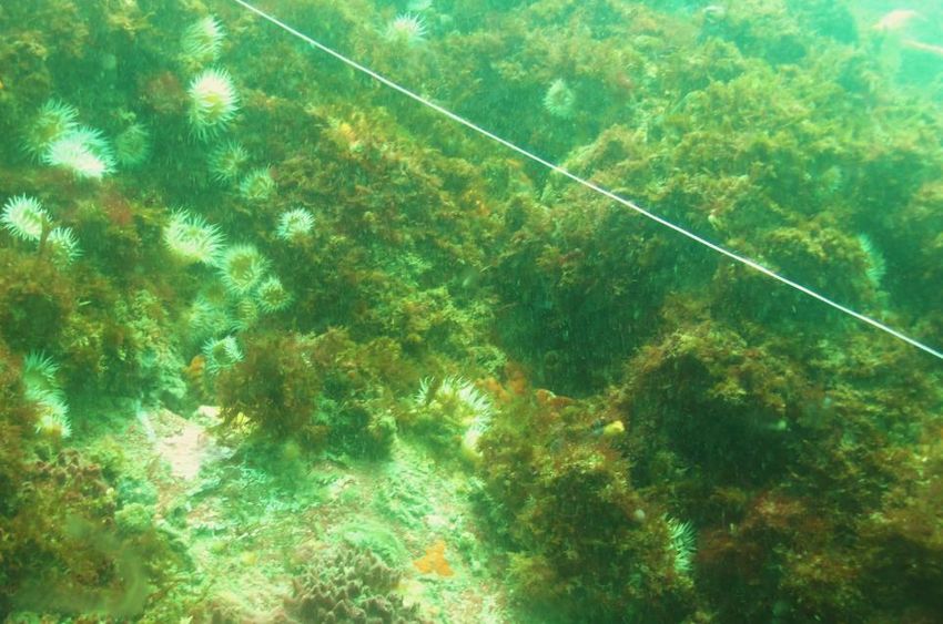
2009). The survey provides a quantitative assessment of seabed elevation at survey sites and
a qualitative assessment of changes in biological communities at these sites over time.
Methods
Establishment of sites
(For details on initial establishment of sites please refer to Grace (1997)).
Site location and reinstatement of marker pins
The three sites (figure 1) were located by GPS (see site information below for GPS positions).
At each site a shot line was dropped from the dive vessel when the distance to the site
waypoint was less than 3 m. Using this method we were always able to drop our shot weight
within 5 m of the top pin of each transect.
In January 2014, all marker pins were replaced. University of Waikato (UoW) divers familiar
with the sites and pin locations were able to identify a number of existing marker pins and
these were replaced. Where old pins were not relocated, UoW divers determined the
positioning of replacement pins. Commercial divers working on surface air supply from the
Port Vessel “the Edward G” used a pneumatic drill to bore holes into the reef surface to a
depth of 15 cm. Stainless steel rods were then secured in these holes using epoxy cement.
Approximately 30 cm of stainless rod was left protruding from each hole. Each transect was
photographed and surveys were subsequently conducted in May 2014, November 2015 and
April 2018.
Photographic surveys
At each site, a survey tape was run from the shallowest to deepest marker pin and then
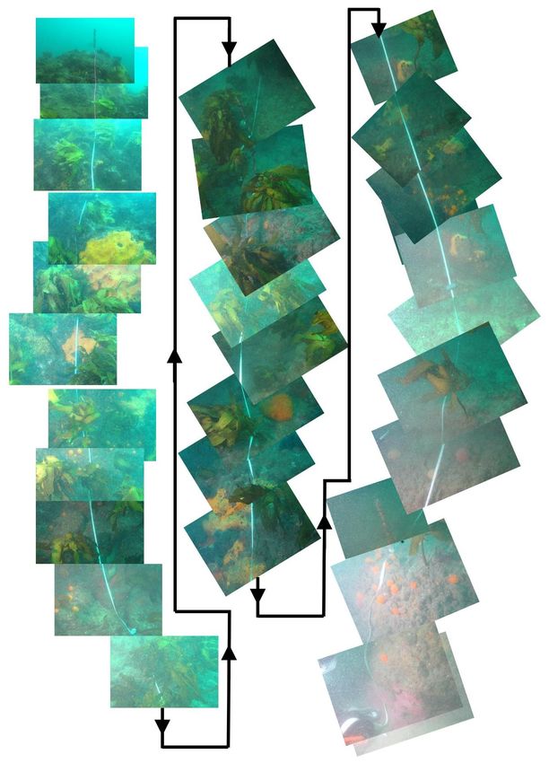
down to the reef-sand interface. Video or still images were then recorded across the entire
length of each transect. In 2018, still images were stitched together in a photo mosaic to
provide an image of the entire length of the transect.
Measurement of seabed elevation relative to reef
The distance from the bottom (deepest) pin to the reef-sand boundary was recorded at
each site. This measurement was taken to be the shortest distance between the marker pin
and the reef-sand boundary.
6
Figure 1. Chart showing Motuotau and the locations of the three survey reefs (red circles)

                                                                                             7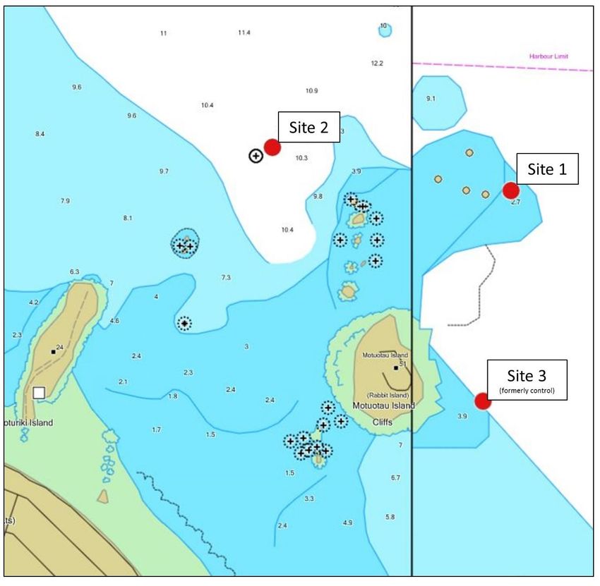
Site 1
One of a group of submerged high rocks seaward of a prominent shallow submerged reef to
the southeast of the reef northeast of Motuotau island.
Coordinates
 Maketu F coordinates:       714654N              276266E
 WGS-83 Lat. Long.:          37° 37’ 37.681S      176° 11’ 51.129E
 Chart Lat. Long.:           37° 37.74S           176° 11.87E
 Metric grid:                6392224N             2792464E
 NZMS 260 U14:               925922

Site 2
On the seaward edge of a patch of rock, locally known as Charlie's Reef, outcropping on the
sandy seafloor, northeast of Wedding Cake Rock.

Coordinates
 Maketu F coordinates:     714760N                 275690E
 WGS-83 Lat. Long.:        37° 37 34.189S          176° 11’ 27.652E
 Chart Lat. Long.:         37° 37.68S              176° 11.49E
 Metric grid:              6392355N                2791909E
 NZMS 260 U14:             919924

Site 3 (formerly called Control site)
Outer edge of a small submerged patch reef southeast of Motuotau island.

Coordinates
 Maketu F coordinates:        714130N             276200E
 WGS- 1983 Lat. Long.:        37° 37’ 54.671S     176° 11’ 48.376E
 Chart Lat. Long.:            37° 37.93S          176° 11.70E
 Metric grid:                 6391881N            2792202E
 NZMS 260 U14:                922919

                                                                                              8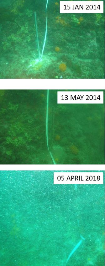
Results
Seabed elevation
Variations in seabed elevation are presented in table 1 and in figure 2. At site 1, the distance
to the reef-sand boundary varied between 0.2 m and 0.09 m with no trend of either
increasing or decreasing seabed elevation at this site. At site 2, the distance to the reef-sand
boundary varied between 1.2 m and 1.0 m. Again, there was no trend of either increasing or
decreasing seabed elevation at this site. At site 3, formerly the control site, distance to the
reef-sand boundary varied between 1.1 and 0.8 m. Since May 2014 the pin to boundary
distance has decreased by 0.3m indicating a small increase in seabed elevation at this site.
The increase in seabed elevation recorded at site 3 and the variation recorded at sites 1 and
2 are within the scale of fluctuations that would naturally occur given the reef aspect and
energy environment. Images showing the positions of the bottom pins at the three sites are
shown in figures 3-5.

             Table 1. Tape distance (m) from the bottom marker pin to the reef-
             sand boundary for four survey conducted between 2014 and 2018.
             For site locations refer to figure 1.

                        Survey date        Site 1          Site 2          Site 3
                          15-Jan-14         0.15              1.1               1
                         13-May-14          0.11                1             1.1
                         11-Nov-15          0.09              1.2               1
                           5-Apr-18           0.2           1.05              0.8

      Figure 2. Tape distance (m) from the bottom marker pin to the reef-sand boundary
      over time. For site locations refer to figure 1.

                                                                                              9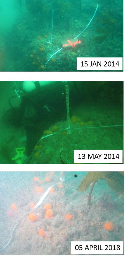
Figure 3. Images of the bottom pin at site 1 in January and May 2014 and April 2018. Visibility
during the 2018 survey was very limited and only close up photos were able to be taken.

                                                                                            10
Figure 4. Images of the bottom pin at site 2 in January and May 2014 and April 2018. Visibility
during the 2018 survey was very limited and only close up photos were able to be taken.
11Figure 5. Images of the bottom pin at site 2 in January and May 2014 and April 2018. Visibility
during the 2018 survey was very limited and only close up photos were able to be taken.
12Biological diversity
Biodiversity was high at all sites (figures 7-9) and is similar to that described in previous
monitoring reports. Although there is evidence of minor changes in the composition of the
reef benthic communities over time this level of variation is to be expected (Shears and
Babcock 2003; Shears and Ross 2010). The most striking change in reef biology was
recorded at site 3 which was previously monitored as a control site. In 2018 an abundance
of mussels (Perna canaliculus, figures 6 and 9) was recorded through the middle and upper
sections of this transect. This observation coincides with reports of greater than usual
mussel spat recruitment to aquaculture farms offshore of Opotiki. Another change to occur
between 2015 and 2018 surveys was the disappearance of a large finger sponge at site 2
adjacent to the bottom marker pin (figure 4). A piece of nylon sack was found wound
around the base of this site marker pin and it is possible that under heavy swell conditions
that this piece of debris may have swept the reef clear of nearby biota projecting far above
the reef surface. Alternatively, it is possible that seabed height may have risen and then
fallen in such a way that sponges on the lower section of reef perished. Lastly, at site 2, the
abundance of sea anemones has been lower since 2015 than in previous years (figure 10).
Figure 6. Mussels (Perna canaliculus) were recorded in high numbers at site 3
in 2018 and are shown here attached to the reef around the base of the
uppermost marker pin.
13Figure 7. Photo mosaic of the permanent transect at site 1 in April 2018.
14Figure 8. Photo mosaic of the permanent transect at site 2 in April 2018.
15Figure 9. Photo mosaic of the permanent transect at site 3 in April 2018.
16Top pin, site 2 - 2001
Top pin, site 2 - 2014
Figure 10. The top marker pins at site 2 in 2001 and 2014. Image comparison
shows the decrease in abundance of Actinothoe anemones that has been
observed at this site.
17Site 1 – photo comparisons
Site 1 - 2001
Site 1 - 2014
18Site 1 - 2014
Site 1 - 1993
19Site 1 - 1998
Site 1 - 2014
20Site 2 – photo comparisons
Site 2 - 2001
Site 2 - 2014
21Site 2 - 1991
Site 2 - 2014
22Site 2 - 2014
Site 2 - 1991
23Site 3 – photo comparisons
Site 3 - 2001
Site 3 - 2014
24Site 3 - 1991
Site 3 - 2014
25Site 3 - 1991
Site 3 - 2014
26Discussion
Measurements of the distance between the bottom marker pin at each site and the reef-sand
boundary indicate some fluctuation in the elevation of the seabed at all sites. At sites 1 and 2
measurements since 2014 indicate both the rise and fall of the reef-sand boundary. At site 3,
formerly monitored as a control site, the seabed has risen over two successive surveys, but
only by 30 cm. The levels of fluctuation observed for the 2014-2018 period are similar or less
than the changes previously reported for the Motuotau reefs (Ross and Pilditch 2009).
Greater fluctuations in seabed elevation are known to occur in this area (P. Ross pers. obs.)
but may not captured by this approximately bi-annual monitoring programme. The data
presented here indicate that the reefs around Motuotau are not being inundated by the
dredge spoils dumped offshore of Mt Maunganui.
Photographic surveys continue to prove useful in capturing information about the diversity
of subtidal reef communities. Surveys between 2014 and 2018 have provided no evidence
of environmental degradation at any of the monitoring sites. There have been some minor
changes to the biological assemblages of the surveyed reefs, including an increase in the
abundance of mussels at site 3 and a decrease in abundance on anemones at site 1. This
level of temporal variation in biological diversity can occur naturally as a function of variable
recruitment, competition and oceanographic conditions and is no cause for concern
(Bertness et al. 2001; Shears and Babcock 2003; Nybakken and Bertness 2004; Shears and
Ross 2010; Rilov and Schiel 2011; South 2016). There is also evidence of considerable
stability in these communities with a number of sponges on these transects having been
present for several decades (refer to site photo comparisons section of report). The ability
to track individual organisms as far back as 1991 provides some confidence that significant
changes in the biology of these reefs would be detectable using the current survey
methodology.
In general terms, the reefs around Motuotau appear to be healthy and in a state that is
comparable to other reefs of similar depth, aspect and exposure along the Bay of Plenty
coastline. It is worth noting that the biological communities of this region have been modified
by the removal of top predator species through fishing. No crayfish (Jasus edwardsii) or
snapper (Pagrus auratus) of legal size were observed while conducting these surveys.
Consequently, the benthic communities surveyed here may not be what would be expected
under entirely natural circumstances. This is not a response of the Port of Tauranga’s dredging
activities but a consequence of the management of fisheries in New Zealand.
27References
Bertness MD, Gaines SD and Hay ME (2001) Processes influencing patterns in marine
communities. In Marine Community Ecology. Sinauer Associates Inc, Massachusetts. 1-
220.
Grace R (1997) ) Monitoring of submerged reef biota off Motuotau Island in relation to dredge
spoil dumping by Port of Tauranga Ltd. Prepared for Port of Tauranga Ltd.
Keeley and Pilditch (1998) Monitoring of submerged reef biota off Motuotau Island in relation
to dredge spoil dumping by Port of Tauranga Ltd. Prepared for Port of Tauranga Ltd.
Keeley and Pilditch (2001) Monitoring of submerged reef biota off Motuotau Island in relation
to dredge spoil dumping by Port of Tauranga Ltd. Prepared for Port of Tauranga Ltd.
Nybakken JW and Bertness MD (2005) Shallow-water subtidal benthic associations. In Marine Biology:
an ecological approach, 6th edition. Pearson Education, San Fransisco. 196-265.
Rilov G and Schiel DR (2011) Community Regulation: The Relative Importance of Recruitment
and Predation Intensity of an Intertidal Community Dominant in a Seascape Context.
Plos ONE. 6: 10.1371/journal.pone.0023958.
Ross PM and Pilditch CA (2009) Monitoring of submerged reef biota off Motuotau Island in
relation to dredge spoil dumping by Port of Tauranga Ltd. Prepared for Port of Tauranga
Ltd.
Ross PM and Pilditch CA (2006) Monitoring of submerged reef biota off Motuotau Island in
relation to dredge spoil dumping by Port of Tauranga Ltd. Prepared for Port of Tauranga
Ltd.
Shears NT and Babcock RC (2003) Continuing trophic cascade effects after 25 years of no-take
marine reserve protection. Marine Ecology Progress Series. 246: 1-16.
Shears NT and Ross PM (2010) Toxic cascades: multiple anthropogenic stressors have complex and
unanticipated interactive effects on temperate reefs. Ecology Letters 13: 1149-1159.
South PM (2016) An experimental assessment of measures of mussel settlement: Effects of
temporal, procedural and spatial variations. Journal of Experimental Marine Biology
and Ecology. 482: 64-74.
28You can also read