PUBLIC TRANSPORTATION MANAGEMENT SYSTEM BASED ON GPS/WIFI AND OPEN STREET MAPS
←
→
Page content transcription
If your browser does not render page correctly, please read the page content below
(IJACSA) International Journal of Advanced Computer Science and Applications,
                                                                                                                    Vol. 6, No. 1, 2015

Public Transportation Management System based on
         GPS/WiFi and Open Street Maps

                                  Saed Tarapiah                                            Shadi Atalla
                       Telecommunication Engineering Dept.                             Lavoro Autonomo (LA)
                           An-Najah National University                                        Torino
                                Nablus,Palestine                                                Italy

    Abstract—Information technology (IT) has transformed many         Although most of GPS-based application depend on real time
industries, from education to health care to government, and is       information collection, the historic GPS collected data intrin-
now in the early stages of transforming transportation systems.       sically has great potential for further offline based application
Transportation faces many issues like high accidents rate in          such as compute the journey speed, congestion monitoring,
general, and much more rate in developing countries due to the        accidents deep analysis such as accidents reason and driver’s
lack of proper infrastructure for roads, is one of the reasons for
                                                                      behavior. Preliminary results of our study are reported in [1]
these crashes. In this project we focus on public transportation
vehicles - such as buses, and mini-buses -, where the goal of the     This project aims to build an open framework that focuses on
project is to design and deploy a smart/intelligent unit attached     traffic and vehicular data for enhancing Public Transportation
to public vehicles by using embedded microcontroller and sensors      Management System (PTMS) efficiency in terms of analysis
and empowering them to communicate with each other through            and planning. The proposed framework consists of four main
wireless technologies. The proposed Offline Intelligent Public        phases namely user data collection, transmission, data analysis
Transportation Management System will play a major role in            and decision making.
reducing risks and high accidents rate, whereas it can increase
the traveler satisfactions and convenience. Here, we propose a             The first phase, data collection, uses off-the-shelf hardware
method, software as well as a framework as enabling technologies      components in order to build Smart on-Board Unit (SBU) that
to for evaluation, planning and future improvement the public         is fitted in to the public Transport Vehicles such as buses and
transportation system. Our system even though can be as whole         mini-buses. SBU endowed with limited processing capabilities,
or parts can be applied all over the world we mostly target           temporary and persistent memory such as EPROM, GPS sensor
developing countries. This limitation mostly appear by consider       and WiFi module to transfer the collected information to
off-shelf technologies such as WiFi, GPS and Open Street Maps
                                                                      database storage. GPS tracking devices collect information
(OSM).
                                                                      regarding the vehicle such as the vehicles geographical location
   Keywords— ITS; GPS; WiFi; Transportation; OSM                      (i.e. longitude and latitude), speed and the driving direction at
                                                                      regular intervals of time [1]. The design of this phase relies
                      I.   I NTRODUCTION                              on integrating multi-sensor capabilities together, in order to
                                                                      increase of the range of possible application that may serve the
    Intelligent Transportation Systems (ITS) have received            public transportation system such as collecting the pollution
much attention in recent years in academia, industry and              level along the road segments.
standardization entities due to their wide impact on people’s
life as their scope to provide vital applications and services            In the second phase, transmission, since we are storing the
to improve transportation safety and mobility and to optimize         data from the earlier phase onto SBU, here we are interested
the usage of available transportation resources and time. ITS         to transfer the information to a back-end server. We are using
applications and services rely on advanced technologies to be         a WiFi-based throwbox to the access point located in the main
deployed and distributed among the intelligent infrastructure         bus station which act as a gateway connected through the
systems and vehicles system. Mainly, these technologies in-           internet to the back-end server. The these data is in central
clude but not limited to physical world perceive technologies         database server based on a trip ID that is unique which is
that able to perform real world measurements and convert them         consist of triplet the vehicle ID, trip start time and end time.
into the digital world, processing and storage capabilities that
                                                                          The third phase, data analyses, the core of this phase is
operate on the digital measurements by storing, analyzing them
                                                                      to inject the bus geographical location at a given timestamp
and communication technologies include wired and wireless
                                                                      along the trip on a digitized map such as open street maps
technologies to exchange the collected data among the vehicles
                                                                      (OSM) each street segment has different attributes such as
them self and also to their infrastructure and vice versa.
                                                                      the street category (pedestrian, highway or motorway) each
    GPS tracking devices stand at the core of the enabling            category has a maximum allowed speed attribute. Here, we
perceive technologies for ITS applications and services. In-          record the number of times a vehicle violates these speed limits
deed, the number of vehicles’ GPS-enabled On-board Unit has           and the corresponding violation time durations. The resulted
sharply increased due to their vital and beneficial rules for both    information is compared to predefined threshold and limits
the vehicles and the drivers. GPS-based services include in-          which allows the system to decide whether the vehicle violated
vehicle satellite navigation, vehicle security system, accident       the traffic regulations or not at a given trip. After running
notification and tracking along with monitoring to name few.          our model for long enough periods, we expect that tracking

                                                                                                                           189 | P a g e
                                                       www.ijacsa.thesai.org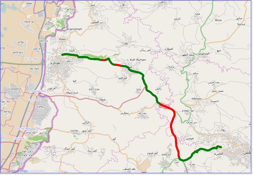
(IJACSA) International Journal of Advanced Computer Science and Applications,
                                                                                                                   Vol. 6, No. 1, 2015

                                                                                       Data Element    Type     Size[Bytes]
and ticketing system can be fed by authorized department
                                                                                        Vehicle ID     String        8
which can be utilized to get clear view about infrastructure                             longitude      float        4
which can be used for developing and planning to improve the                              latitude      float        4
infrastructure on some field or apply some regulations which                               speed        float        4
                                                                                         direction      byte         1
will aim to reduce traffic accidents.                                                   Timestamp     integer        4

    OSM, which provides free geographical information, is                           TABLE II: Single GPS Data Record
sometimes referred to as a map version of Wikipedia. Its data
additions, updates, and corrections are made available by its
participants.
                                                                        3)      Alerting: Send alerts to the driver such as breaking
                                                                                maximum speed on specific road segment while driv-
                    II.   R ELATED W ORK                                        ing.
    This section explores a selected tracking fleet of vehicles         4)      Geo-fencing: Identify geometric shapes over the digi-
solutions appeared on academic and research works so far. This                  tal map where the driver have to avoid while moving.
work considers only solutions span a whole system for tacking           5)      Geo-Casting: Sending Alerting information to spe-
a group of vehicles. In general tracking systems composed of                    cific central office and the vehicles in proximity of
two parts, the first part is on-Board Unit attached to moving                   the vehicle generating accident or alrm situations.
vehicles, whilst the second part is a central application to
collect, to process and to visualize useful reports. This section            III.   S YSTEM M ODEL PHASES AND E NABLING
attempts to classify the considered related work based in                                   T ECHNOLOGIES
different criteria. Each criteria requires intrinsic requirements
to build the system.                                                 A. GPS Data Collection
                                                                          GPS tracker data used in this work is supplied from SBU
   Table I presents and compares selected related works based
                                                                     fitted to public transportation vehicles. This data consist of
on the following criteria.
                                                                     one record for each instance a vehicle reported its position.
    The first criteria (namely Type) differentiates between on-      Each record includes Vehicle ID, vehicle type, position coor-
line and offline tracking systems. While online systems require      dinates(longitude and latitude), speed, date and time, direction.
the on-Board Unit to have permanent (available everytime and            Table II illustrates the GPS data record of interest. The
everywhere) connection with the central application. In the          Data type is described by C programming language notations.
contrary Offline systems aggregate the collected data on a local     SBU stores the while GPS data record but the Vehicle ID.
storage unit and communicates with the central application           The total size of each locally stored GPS recoded equals 17
only when the communication link available such as WiFi.             Bytes. With second-to-second data logging the SBU requires
The Offline systems focus on historical data processing and          17 × 60 × 60 = 61200 Bytes of local storage to accommodate
visualizing the generated reports( such as track a vehicle over      one hour of GPS recording.
a digital map). The offline system data transmission can be
handled manually such as removing the on-Board Unit form                The Vehicle ID is an unique identifier but is anonymous
the vehicle and connected it to a PC and transfer the data.          and does not include information about the driver identity.
Finally, some systems can be considered as online, offline or
                                                                         If the vehicle moves away from the source bus station (the
combined (online and offline) solutions.
                                                                     wireless connection with access point will not be available)
    The second criteria (namely Smart Unit Type) here we             then SBU will perceive and store the GPS recodes data into
differentiate between different types of hardware used for           a local storage for off-line data logging. If the vehicle arrives
build on-Board Unit for the tracking system. Three main units        close to the destination bus station, (the wireless connection
hardware are considered, first Commercial unit available in          reestablished again) the SBU will send the collected trip data
the market, second option could be available smart Phone             to the gateway storage in the bus-station and will delete it is
with GPS and wireless links, the last option is the customized       local copy for the sake on disk space.
unit( where authors provide design and implementations in the            SBU is equipped with motion detection sensory device.
considered work).                                                    Which means that SBU can detect anonymously and automat-
    The third criteria (namely connection Type) which states         ically if it is moving or in stationary state. Through this way
the communication channel used by the on-Board Unit to               the SBU will log GPS data if it is moving and it will go to
transfer the collected data. Such connections could be any           sleep mode and stop collecting GPS data if it detect that it is
cellular connection or combination of them such as GPRS,             in stationary state for the last 5 minutes and when the SBU
SMS and 3G for simplicity we call it cellular connection.            moves again to will resume collecting the GPS data.

    Last criteria (namely Features) this part we make compar-        B. GPS Data Transmission
ison between different tracking systems such as : features:
                                                                          This includes the tools and mechanisms to transfer the
   1)    Visual Vehicles’ Tracking : the ability to project the      perviously collected GPS data to the back-end server for
         vehicle trip onto geographic digital map.                   permanent storage in database system. Furthermore, it also
   2)    Instantaneous Vehicles Speed : Reporting the vehicle        considers the intermediates transfer from one place to another
         speed along the travelling track.                           till arrive it final back-end server.

                                                                                                                              190 | P a g e
                                                      www.ijacsa.thesai.org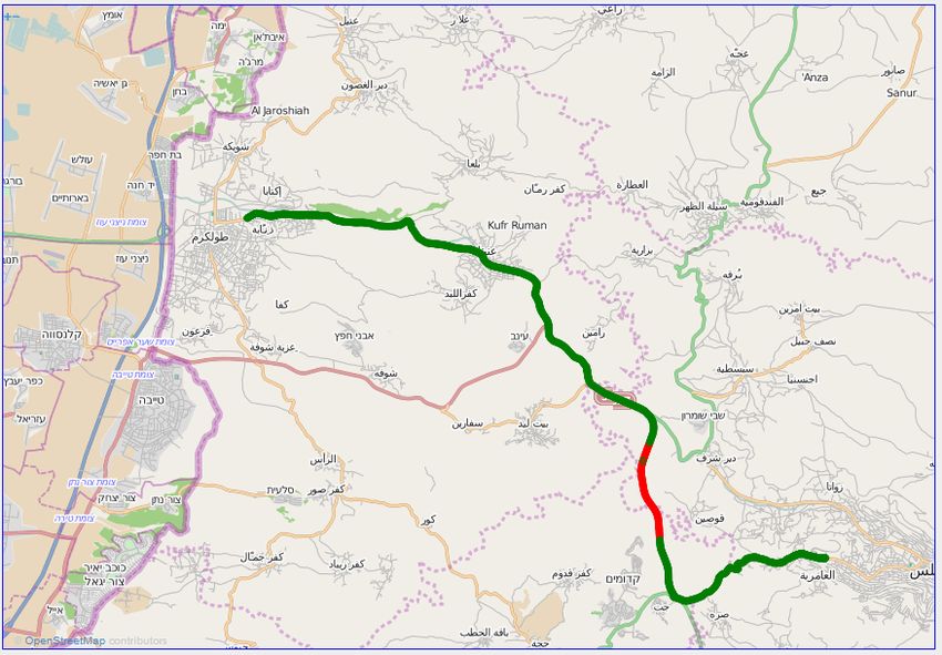
(IJACSA) International Journal of Advanced Computer Science and Applications,
                                                                                                                        Vol. 6, No. 1, 2015

                                                                                                               Features
               Reference(s)     Type     Smart Unit Type    Connection Type
                                                                                 Tracking      Speed      Alerting    Geo-fencing    Geo-Casting
                 [2], [3]      Online     Custom Unit            GPRS              Yes          Yes         Yes           No             No
                    [4]        Online     Custom Unit       GPRS and SMS           Yes          No          Yes           No            Yes
                    [5]        Online     Custom Unit            GPRS              Yes          Yes         No            No             No
                    [6]        Online     Custom Unit            SMS               Yes          Yes         No            No             No
                   [7]        Combined    Custom Unit            GPRS              Yes          Yes         Yes           No             No
                   [8]        Combined    Custom Unit            SMS               Yes          No          No            No             No
                   [9]        Combined   Commercial Unit    GPRS and SMS           Yes          Yes         Yes          Yes             No
                   [10]       Combined    Smart Phone      GPRS, 3G and SMS        Yes          Yes         Yes           No             No
                   [11]        Online     Smart Phone          Cellular            Yes          Yes         No            No             No

                                TABLE I: Features of Others Vehicle Monitoring & Tracking Systems

    The transmission technologies vary among many commu-
nication option depending the intended application for instance
real time tracking application will require an instance and                                                                                             ^ĂƚĞůůŝƚĞ
permanent mobile connection to the back-end server or any
intermediate stage which always have direct connection to the                                 h^
                                                                                                       ^ŵĂƌƚŽŶͲŽĂƌĚ
                                                                                                                              'W^ZĞĐĞŝǀĞƌ
back-end server. Cellular connections (2G, 3G, and LTE) are                                                 hŶŝƚ

the conventional shapes of communication to this purposes.                    WƌŽŐƌĂŵŵŝŶŐΘ
                                                                                ĞďƵŐŐŝŶŐ
Whilst for non real time application, in particular this work,
this ease a lot the communication challenges. Thus, the com-                                            tŝ&ŝDŽĚƵůĞ

munication options include the aforementioned ones plus other
options like vehicle mobility which is well known as Delay
Tolerant Networks (DTN). DTN exploits the vehicle mobility
to transfer the GPS collected data from one point to another.
                                                                                                                                    /ŶƚĞƌŶĞƚ
[12].
                                                                                                                                                     ĂĐŬͲĞŶĚ^ĞƌǀĞƌ

                                                                                              Fig. 1: System High Level Architecture.
C. GPS Data Analysis
    1) Injecting GPS Data into Map: We utilized Open Street
Map [13] to inject the travel path along the trip by using the                A. Smart on-Board Unit (SBU) MAIN COMPONENTS
javascript library Open Layer [14].
                                                                                 Here we provide detailed description about the used hard-
    2) Measurements and Statistics : Different statistics can                 ware modules by the SBU:
be carried out on the collected data with different criteria
it cloud be statistics on a given trip, a give route, a give                      1)        The Arduino Uno (DEV-11021)Figure 2:which is an
time period, or on a given vehicle behaviour. Driver’s Average                              open hardware source controller, which is recently
Speed distribution - String -For each trip we calculate the                                 being used in many applications, due to its high
average speed along the trip after having number of runs/trips                              performance, and easy to deal with. the Arduino
we cloud identify the best fit distribution that describes the                              Microcontroller board is based on the ATmega328,
average along given path per driver/vehicle moreover since we                               which has 14 digital input/output pins (of which
consider a give road followed by every public transportation                                6 can be used as PWM outputs), 6 analog inputs,
vehicle(mandatory) so the total trip distance in kilome ter is                              a 16 MHz ceramic resonator,32k Flash Memory, a
fixed (i.e. 25 km for we consider path Toulkarem/Nablus). But                               USB connection, a power jack, and a reset button. It
the trip traveling duration directly proportional to the average                            contains everything needed to support the microcon-
speed such information cloud be used to estimate the vehicle                                troller; simply connect it to a computer with a USB
arrival at the given bus stop and cloud be used for enhancing                               cable or power it with an AC to DC adapter or battery
the travel scheduling to be more realistic. pathway’s Average                               to get started [15],
Speed distribution - String - For each trip we calculate the                      2)        Arduino GPS Shield (GPS-10710) Figure 3:is a high
average speed along the trip after having number of runs/trips                              accuracy GPS receiver, which is used in our system
we cloud identify the best fit distribution that describes the                              due to its great characteristics and features such as
average along given path per route/pathway.                                                 this module can be easily integrated to the Arduino
                                                                                            board, GPS-10710 is able to give the vehicle location
                                                                                            within a few meters, this GPS module also gives
  IV.   ARCHITECTURE AND IMPLEMENTATIONS                                                    accurate time reading which is an important feature
                                                                                            to provide a good distributed synchronization mech-
    This section depicts the high level architecture( as shown                              anism to our system and all the control messages
in Figure 1) of the proposed system by identifying the main                                 between the GPS receiver and the Arduino micro-
building blocks which consists the SBU which is mounted and                                 controller are performed using the well-known AT
attached to the vehicles. In addition, the Web based application                            commands standard [15],
running on the back-end server is introduced.                                     3)        Arduino Wi-Fi Shield (DEV-11287) Figure 4: this

                                                                                                                                                   191 | P a g e
                                                           www.ijacsa.thesai.org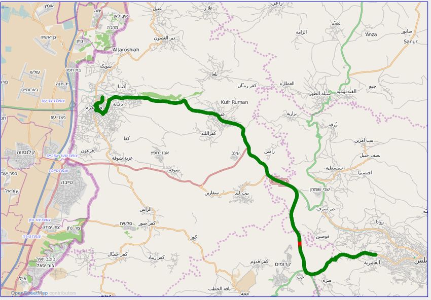
(IJACSA) International Journal of Advanced Computer Science and Applications,
                                                                                                        Vol. 6, No. 1, 2015

                                                          B. Web Based Application
                                                              In order to make our Web Application flexible and extend-
                                                          able, we have adapted the REST (RESTful) architecture. And
                                                          our implemented system has used the three-tier architecture
                                                          [28]:
                                                             1)     A front-end which relate to the client side. The user
                                                                    interface is based on a web-browsers application.
                                                                    It contains a responsive web page developed using
                                                                    Hypertext Transfer Markup Language v.5 HTML5 ,
                                                                    Javascript , JQuery library and Cascading Style Sheet
                                                                    (CSS) whose application is tested on both desktop
                                                                    and smartphone web browsers. This web page uses
Fig. 2: Arduino Uno Microcontroller [15].                           Asynchronous JavaScript AJAX in order to build
                                                                    bidirectional data flow with middle layer.
                                                             2)     A middle layer which includes a dynamic PHP pro-
                                                                    gram running on top of Apache web server. This
                                                                    program exposes its internal functionality through a
                                                                    RESTful interface towards the front-end and it uses
                                                                    the MySQL native driver for PHP for storing and
                                                                    retrieving data.
                                                             3)     A back-end containing MySQL database server used
                                                                    to store all known roads in the region, system users,
                                                                    users profiles and user alerts. This component is a
                                                                    relational database that is used to store and retrieve
                                                                    the data. Note that the positioning and speed data are
                                                                    time-stamped according to the UTC time reference.
                                                               In RESTful vocabulary things are resources. Each resource
                                                          is a uniquely addressable entity by a Universal Unique Iden-
                                                          tifier (URI) attached to it. Moreover, each resource has a
 Fig. 3: GPS-10710 Shield Module [15].
                                                          representation which can be transferred and manipulated by
                                                          means of four verbs. These verbs are create, read, update and
                                                          delete (CRUD).

Shield allows an Arduino board to connect to the              V.    F UNCTIONAL T ESTING AND U SER E XPERIENCE
internet using the 802.11b/g wireless specification
(WiFi).the shield has an Atmega 32UC3 which pro-              In order to test the system prototype, we attached our
vides a network (IP) stack capable of both TCP and        system box to a public transportation vehicle (mini-bus) trav-
UDP. In addition, the shield has an onboard micro-        eling on the same route/path between two cities; namely, from
SD card slot, which is mainly used to locally store       Tulkarem to Nablus.
the user data on SBU along the trip, before being             we have collocated and locally recorded the trips informa-
transferred to the central server via WiFi link. [15].    tion (i.e. long., lat., Speed, and timestamp),based on the system
                                                          model, these information will be transferred via WiFi link to
                                                          the gateway allocated in the final bus station, by turn, such
                                                          data will be inserted in the corresponding DataBase. in order
                                                          to analyze drivers behavior, we are interested in two kind of
                                                          plots, first plot Figure 5 depicts for each trip, the vehicle speed
                                                          along the route, while in the second plot as in Figure 6 we show
                                                          the traveled path along the trip, notice that, the corresponding
                                                          plot was generated using Open Street Maps (OSM) API [13].
                                                          we have considered for analysis Five different trips of the same
                                                          driver with the same vehicle, it is worth to mention that, these
                                                          data are collected almost in the same time during a normal
                                                          working day with almost same weather conditions.
                                                              in order to analyze the speed violation, we know that
                                                          the maximum allowed speed limit on the outside city roads
                                                          in Palestine is configured to be 90 Km/h, while it is 60
                                                          Km/h for inside city road segments. by looking to Figure 5,
    Fig. 4: Wi-Fi Shield Module [15].                     we notice that, the driver in first trip does not exceed the
                                                          maximum allowed speed limit; the dotted horizontal line,

                                                                                                                192 | P a g e
                                            www.ijacsa.thesai.org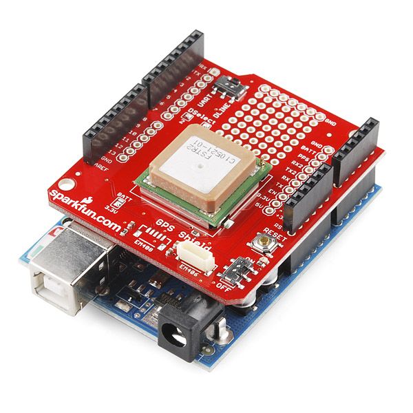
(IJACSA) International Journal of Advanced Computer Science and Applications,
Vol. 6, No. 1, 2015
140 140
Speed Speed
120 Max allowed speed 90Km/h 120 Max allowed speed 90Km/h
100 100
Speed km/h
Speed km/h
80 80
60 60
40 40
20 20
0 0
0 5 10 15 20 25 30 0 5 10 15 20 25 30
Traveled Distance in KM Traveled Distance in KM
(a)Trip 101 (b)Trip 102
(a)Trip 101 (b)Trip 102
140 140
Speed Speed
120 Max allowed speed 90Km/h 120 Max allowed speed 90Km/h
100 100
Speed km/h
Speed km/h
80 80
60 60
40 40
20 20
0
0 5 10 15 20 25 30
0
0 5 10 15 20 25 30
(c)Trip 103 (d)Trip 104
Traveled Distance in KM Traveled Distance in KM
(c)Trip 103 (d)Trip 104 Fig. 6: Traveled Path along the route for Four different trips:
(a) Trip 101; (b) Trip 102; (c) Trip 103; and, (d) Trip 104.
Fig. 5: Driving speed along the route for Four different trips:
(a) Trip 101; (b) Trip 102; (c) Trip 103; and, (d) Trip 104.
ison with the others management systems based on GPRS
and GPS technology, it is greatly reduced the operating price.
indicates the 90Km/h speed limit, while the connected dotted In our system, the Open Street Maps plays a major rule
line is related to 60Km/h speed limit. moreover, we could during monitoring, visualization and identifying the maximum
notice that the driver in the second trip 5(b) violates the allowed speed for each road segment along with the traveled
speed limit frequently in comparison to other trips.on the route. Ongoing work is to enable the system for supporting
contrary, the driver in the third trip 5(c) almost did not violates online tracking and monitoring services, by using mobile data
the maximum allowed speed. for more analysis. some related networks.
statistics are shown in the table III. it shows for each of the four
trips the corresponding, ID, starting date and time, traveled
distance in Kilometers unit, traveling trip duration in minutes, R EFERENCES
average vehicle speed along the whole trip, vehicles maximum [1] S. Tarapiah, S. Atalla, N. Muala, and S. Tarabeh, “Offline public
reached traveling speed, the maximum legal allowed speed transportation management system based on GPS/WiFi and open street
on the outside city road segments, the exceeding max speed maps,” in CICSyN2014, 6th Int Conference on Computational Intelli-
duration in Minutes, this metric accumulates the time duration gence, Communication Systems and Networks (CICSyN2014), Tetovo,
Macedonia, the former Yugoslav Republic of, May 2014.
when driver exceeds the speed limit, while the last metric,
[2] S. Tarapiah, R. AbuHania, and D. J. Islam Hindi, “Applying web
indicates the percentage of violation duration to the total trip based gps/gprs ticketing and tracking mechanism to reduce traffic
duration. from the statistics in the earlier table, it is easy to violation in developing countries,” in The International Conference
notice that the driver violates the speed during the second trip, on Digital Information Processing, E-Business and Cloud Computing
where the violation percentage is almost 20% of the time. (DIPECC2013). The Society of Digital Information and Wireless
Communication, 2013, pp. 102–106.
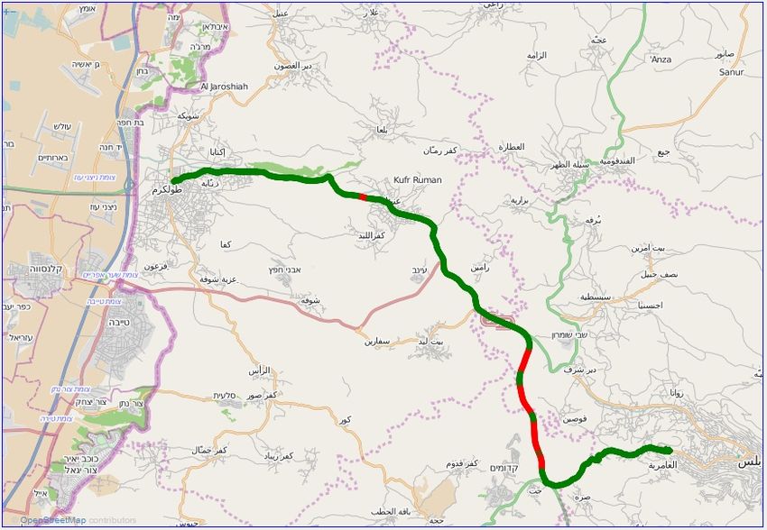
Furthermore, Figure 6 shows the followed path for the [3] S. Tarapiah, S. Atalla, and R. AbuHania, “Smart on-board transportation
first four trips, we found that all trips follow the same path management system using gps/gsm/gprs technologies to reduce traffic
along the route, in addition, we indicates on the track (red violation in developing countries,” International Journal of Digital
points) the segments where the driver violates the maximum Information and Wireless Communications (IJDIWC), vol. 3, no. 4, pp.
96–105, 2013.
speed limit, in fact, by referring to the authorized national
[4] S. Tarapiah, S. Atalla, and B. Alsayid, “Smart On-Board transportation
transportation system, we found that recently, many traffic management system Geo-Casting featured,” in International Conference
accidents happened on that segment. on Computer Information Systems 2014 (ICCIS-2014), Hammamet,
Tunisia, Jan. 2014.
VI. C ONCLUSIONS [5] G. A. Giannopoulos, “The application of information and commu-
nication technologies in transport,” European Journal of Operational
Recently, the demand for developing public transportation Research, vol. 152, no. 2, pp. 302–320, 2004.
management systems(PTMS) using GPS technologies have [6] M. Al-Rousan, A. Al-Ali, and K. Darwish, “Gsm-based mobile tele-
sharply increased due to the fact that, a well designed PTMS monitoring and management system for inter-cities public transporta-
tions,” in Industrial Technology, 2004. IEEE ICIT’04. 2004 IEEE
will save human life by monitoring the driver behaviour which International Conference on, vol. 2. IEEE, 2004, pp. 859–862.
in turn will reduce number of times when the driver violate
[7] M. Popa and B. Suta, “A solution for tracking a fleet of vehicles,” in
traffic regulations. This paper introduces system composition Telecommunications Forum (TELFOR), 2011 19th. IEEE, 2011, pp.
structure and explains the system software and hardware 1558–1561.
design. Experiments show that our system is practicable and [8] C. Koukourlis, S. Spyridakis, and N. Kokkalis, “On the design of a
reliable of data transmissions using WiFi links, with compar- fleet monitoring system with reduced power consumption,” Electrical
193 | P a g e
www.ijacsa.thesai.org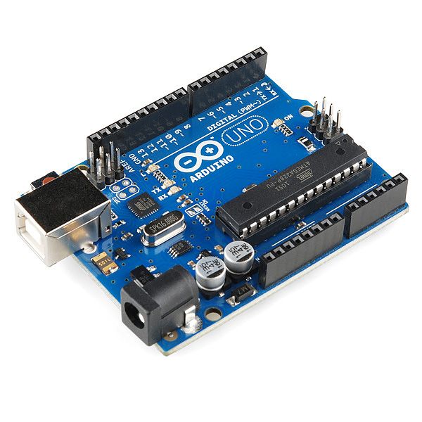
(IJACSA) International Journal of Advanced Computer Science and Applications,
                                                                                                                              Vol. 6, No. 1, 2015

 Trip ID                                         1                   2                  3                  4                  5
 Starting Time                           1 19 2014 9 22am    1 20 2014 8 16am   1 21 2014 9 37am   1 22 2014 8 28am   1 23 2014 9 34am
 Distance (Km)                                27.122               26.65              28.95              26.15              25.03
 Duration (minutes)                            28.62                25.4              34.48              26.36               26.8
 Average Speed (Km/H)                          56.86               62.96              50.37               59.5              56.03
 Maximum Speed                                 101.7               115.2               94.5              100.8              109.8
 Maximum Allowed Speed(km/h)                     90                  90                 90                 90                 90
 Exceeding Max allowed Speed Duration           2.85                4.95               0.37               1.9                3.43
 Violating Speed (%)                           09.69               19.49              01.06              07.20              12.81

                                                         TABLE III: Trips Related Statistics.

       Engineering, vol. 84, no. 4, pp. 203–210, 2002. [Online]. Available:
       http://dx.doi.org/10.1007/s00202-002-0120-z
 [9]   I. M. Almomani, N. Y. Alkhalil, E. M. Ahmad, and R. M. Jodeh,
       “Ubiquitous gps vehicle tracking and management system,” in Applied
       Electrical Engineering and Computing Technologies (AEECT), 2011
       IEEE Jordan Conference on. IEEE, 2011, pp. 1–6.
[10]   I. A. H. Eltoum and M. Bouhorma, “Velocity based tracking and local-
       ization system using smartphones with gps and gprs/3g.” International
       Journal of Computer Applications, vol. 76, 2013.
[11]   J. Biagioni, T. Gerlich, T. Merrifield, and J. Eriksson, “Easytracker:
       automatic transit tracking, mapping, and arrival time prediction using
       smartphones,” in Proceedings of the 9th ACM Conference on Embedded
       Networked Sensor Systems. ACM, 2011, pp. 68–81.
[12]   Y. Lou, C. Zhang, Y. Zheng, X. Xie, W. Wang, and Y. Huang, “Map-
       matching for low-sampling-rate gps trajectories,” in Proceedings of
       the 17th ACM SIGSPATIAL International Conference on Advances in
       Geographic Information Systems. ACM, 2009, pp. 352–361.
[13]   “Open        Street     Map,”      2014.      [Online].     Available:
       http://www.openstreetmap.org/
[14]   “Javascript Library Open Layer,” 2014. [Online]. Available:
       http://openlayers.org/
[15]   “SparkFun Electronics,” 2013. [Online]. Available: www.sparkfun.com

                                                                                                                                         194 | P a g e
                                                                 www.ijacsa.thesai.org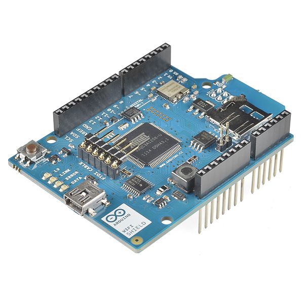
You can also read